
Wake County Unincorporated
City Zoning Code
City Zoning Code
ARTICLE 5
Lot and Building Standards
5-10 - General.
Residential development must comply with the conventional development standards of Section 5-11 or the open space development standards of 5-12.
[Amended on 11/21/2022 by OA-02-22]
5-11 - Conventional Development.
5-11-1
Residential Watershed Districts. The following standards apply in the residential watershed districts unless otherwise expressly stated. Special standards apply, for example, to approved open space developments, attached houses and lot line houses. See Part 3 of this Article for rules governing measurement of and exceptions to these standards.
[1] In some cases, more restrictive standards may apply to lots within the Swift Creek, Little River and Smith Creek Water Supply Watersheds. See Article 11. Part 3.
[2] Lots created after 7/01/2001 are subject to Wake County stormwater management regulations.
[3] Nitrogen export check required and is limited to 3.6 lbs./ac./yr. without best management practices or payments made to the N.C. Ecosystem Enhancement Program. Does not apply to nonresidential development in R-80W and R-40W districts.
[4] Limit may be increased to 24% provided that first ½" of rainfall runoff is retained.
[Amended on 6/4/2012 by OA 02-12]
5-11-2
Non-Watershed Residential Districts. The following standards apply in the non-watershed residential watershed districts unless otherwise expressly stated. Special standards apply, for example, to approved open space developments, attached houses and lot line houses. See Part 3 of this Article for rules governing measurement of and exceptions to these standards.
[1] In some cases, more restrictive standards may apply to lots within the Swift Creek, Little River and Smith Creek Water Supply Watersheds. See Article 11, Part 3.
[2] Lots created after 7/01/2001 are subject to Wake County stormwater management regulations.
[3] Nitrogen export check required and is limited to 3.6 lbs./ac./yr. without best management practices or payments made to the N.C. Ecosystem Enhancement Program. Does not apply to nonresidential development in R-80W and R-40W districts.
[4] Maximum height in R-5 = 35 feet or one foot of building height for each three feet that the building is set back from front, side and rear property lines, whichever allows the greater height.
[5] Nonresidential Development in HD may exceed 30 percent maximum impervious. See 3-23-5(A)(2).
Commentary: At the time of subdivision plat review, Wake County's Department of Environmental Services will review subdivisions for compliance with impervious surface coverage limitation. This review will be based on the total impervious surface coverage of the subdivision as a whole, as opposed to the impervious cover on individual lots. Stormwater management devices will be required if the subdivision as a whole exceeds 15 percent impervious cover.
[Amended on 1/22/2008 by OA 04-07; Amended on 1/3/2022 by OA-03-21; Amended on 11/21/2022 by OA-02-22]
5-12 - Open Space Development.
5-12-1
Purpose. The regulations of this section are intended to encourage subdivision design that is more efficient and provides greater protection of open space and natural resources than conventional subdivision designs. Open space subdivision design allows more compact and less costly networks of roads and utilities. They also help reduce stormwater run-off and non-point source pollutant loading rates and may help to preserve an area's rural character. Open space subdivisions are intended to encourage the provision of needed open space and recreational amenities for residents, while also helping to retain an area's character and preserve natural, environmentally sensitive, agricultural, and historic resources.
[Amended on 11/21/2022 by OA-02-22]
5-12-2
General Description.
(A)
The open space development standards of this section require that a specified portion of each subdivision be set aside and permanently preserved as open space.
(B)
The required open space area within open space developments can be used to provide recreational opportunities for the subdivision's residents, to conserve and protect significant natural resources, or to conserve productive farming and forestry uses.
[Amended on 11/21/2022 by OA-02-22]
5-12-3
Minimum Subdivision Site Size.
(A)
Open Space Development. The minimum required land area for an open space development is ten acres.
[Amended on 11/21/2022 by OA-02-22]
5-12-4
Minimum Open Space
(A)
Open Space Development.
(1)
At least ten percent of the land area within an open space development must be set aside and permanently preserved as open space if the development is located outside of a Water Supply Watershed.
(2)
Open space developments located within a Water Supply Watershed must set aside and permanently preserve at least 25 percent of the subdivision's total land area as open space.
[Amended on 8/1/2011 by OA 02-11; amended on 11/21/2022 by OA-02-22]
5-12-5
Density and Lot Size.
(A)
Open Space Development. The following density and lot size standards apply to all open space developments without community wastewater. (See Part 3 of this Article for rules governing measurement of and exceptions to these standards):
[1] More restrictive standards may apply to lots within the Swift Creek, Little River and Smith Creek Water Supply Watersheds. See Article 11, Part 3
[2] Minimum lot area per dwelling unit. For example, duplex in R-80 district requires minimum lot area of 80,000 square feet.
[3] Residential uses in the GB and O&I districts must comply with the requirements of the R-20 and the R-30 districts, respectively.
(B)
Reserved.
(C)
Open Space Development With Community Water and Wastewater Service. The following density and lot size standards apply to all open space developments that are served by both community water and sewer facilities. (See Part 3 of this Article for rules governing measurement of and exceptions to these standards):
[1] More restrictive standards may apply to lots within the Swift Creek, Little River and Smith Creek Water Supply Watersheds. See Article 11, Part 3.
[2] Minimum lot area per dwelling unit. For example, duplex in R-80 district requires minimum lot area of 40,000 square feet.
[3] Residential uses in the GB and O&I districts must comply with the requirements of the R-20 and the R-30 districts, respectively.
[Amended on 1/22/2008 by OA-04-07; Amended on 1/3/2022 by OA-03-21; Amended on 11/21/2022 by OA-02-22]
5-12-6
Additional Lot and Building Standards. The following additional lot and building standards apply to open space developments. (See Part 3 of this Article for rules governing measurement of and exceptions to these standards):
[1] Minimum perimeter setback applies only around the perimeter of the open space subdivision. Minimum perimeter setback standards apply to principal buildings. No additional perimeter setback is required for cluster or open space subdivisions abutting other cluster or open space subdivisions that have already provided the required perimeter setback.
[2] Minimum required front yard and corner yard setbacks on a corner lot cannot be reduced.
[Amended on 11/21/2022 by OA-02-22]
5-12-7
General Requirements
(A)
Maximum Density.
(1)
The maximum number of dwelling units allowed within an open space development is equal to the site's total land area (developable area + open space) multiplied by the maximum density standard shown in Section 5-12-5.
(2)
If the open space development site (subdivision) is located in more than one zoning district, the maximum number of dwelling units allowed must be determined separately for each portion of the site lying within a different zoning district. Density may be transferred from one portion of the site to another, provided that such transfers do not result in an increase in the number of dwelling units allowed on the overall site.
(B)
Lot Design. Each lot must be regularly shaped and meet or exceed the minimum lot area and lot width standards in this section. Side lot lines extending from a road must be approximately perpendicular or radial to the road's right-of-way boundary.
(C)
Open Space.
(1)
Required Open Space. The amount of open space within an open space development must equal or exceed the minimum open space requirements of Section 5-12-4. Open space provided to meet minimum open space requirements must be in one or more parcels dedicated or otherwise protected as permanent, active or passive open space.
(2)
Use, Location, and Design.
(a)
Open space must be dedicated or reserved for one or more of the following uses:
i.
Conservation of, and avoidance of development in, any readily identifiable natural hazard areas, i.e., areas that potentially pose a significant hazard to people or property (e.g., designated floodways, other perennially wetlands, and lands whose slope and/or soils make them particularly susceptible to erosion when disturbed by development activities);
ii.
Conservation and protection of any identified significant natural areas (e.g., rare plant communities, important wildlife habitat) or other environmentally sensitive areas where development might threaten water quality or ecosystems (e.g., watershed buffers, groundwater recharge areas);
iii.
Conservation and protection of any identified important historic resources (e.g., homesteads, mills, barns, archeological sites);
iv.
Provision of active and/or passive outdoor recreation opportunities (e.g., ballfields, playgrounds, tennis courts, swimming pools, basketball courts, golf courses, bikeways, walking trails, nature trails, and picnic areas), either for the general public or for the subdivision's residents or employees and their guests (Note: this does not preclude a membership requirement or monetary charge for use of recreation facilities such as a golf, swim or tennis club, as long as subdivision residents or employees have an opportunity to join the club or pay to use club facilities; or
v.
Retention of productive farmland or forestland for continued agricultural and/or forestry use or areas adjacent to farmlands designated as a voluntary agricultural district or enhanced voluntary agricultural district.
(b)
Highest priority for the location, design, and use of open space must be given to conserving, and avoiding development in, any natural hazard areas on the subdivision site.
(c)
Open space may contain only such buildings, structures, accessways, and parking facilities as are necessary and accessory to its principal uses (e.g., pedestrian path, recreational club house, utility lines, driveway, small parking area, barns and other farm storage and processing facilities). Open space areas may be utilized for irrigation of reclaimed water meeting the standards set forth in 15A NCAC 02H.0219(k) of the North Carolina Administrative Code. Open space areas may not contain sewage treatment ponds that are utilized as the primary means of wastewater treatment or be utilized for irrigation of wastewater that does not meet reclaimed water standards as specified above.
(d)
Open space may contain individual water supply wells or subsurface sewage disposal fields serving dwelling units on adjacent lots, or community wells, provided they do not conflict with the principal uses of the open space. Open space areas may not contain sewage treatment ponds that are used as the primary means of treatment of wastewater and the spray application of wastewater that does not meet applicable water reuse standards.
(e)
The location, size, character, and shape of required open space must be appropriate to its intended use(s). (e.g., open space proposed to be used for recreation, particularly active recreation, should be located and designed so that it can be accessed conveniently and safely by intended users, and open space to be used for ballfields, playing fields, or other active recreational facilities should be located on land that is relatively flat and dry.)
(D)
Open Space Dedication or Reservation.
(1)
Subdivision occupants must be ensured direct access to and use of an amount of the subdivision's open space equal to a minimum of ten percent of the area of the development site, by conveying that portion of open space to a property owners association or similar legal entity meeting the provisions of Section 8-23, or to a public agency or nonprofit organization that is organized for, capable of, and willing to accept responsibility for managing the open space for its intended purpose, and that will ensure subdivision occupants direct access to and use of the open space. Any other open space provided may be conveyed to such organizations as listed above or to any agency, organization, person, or other legal entity that is organized for, capable of, and willing to accept responsibility for managing the open space for its intended purpose, provided such conveyance is restricted to ensure continued maintenance and preservation of the open space.
(2)
Each dedicated or reserved open space parcel must be shown on all subdivision plans and on a record plat recorded with the Wake County Register of Deeds, with a notation of its area and its intended open space use (subparagraph 5-12-7(C)(2)). The owner of an open space parcel may re-dedicate or re-reserve the parcel for another open space use allowed under this subsection by recording a record plat showing the parcel and its new intended open space use.
(E)
Maintenance.
(1)
The owner of the open space is responsible for maintaining the open space so that it continues to effectively function for its intended use, and any dedication or conveyance of an open space parcel must provide for such responsibility.
(2)
Where the open space development is located within a R-40W, R-80W, WSO-2NC, WSO-3CA, WSO-3NC, or WSO-4P district, retention of undeveloped open space in a vegetated or natural state (as required in subsection 5-12-9) must be ensured by maintenance provisions filed with the Wake County Register of Deeds, either as part of recorded documentation providing for establishment of an appropriate legal entity (e.g. homeowners association, property owners association or land conservation organization) that is to be responsible for maintenance and control of open space (as provided for in Section 8-23), or in a maintenance agreement recorded with the property deeds.
[Amended on 11/21/2022 by OA-02-22]
5-12-8
Potential Future Development Sites.
(A)
When an open space development is located within areas designated as Municipal Transition Area and the maximum allowed density under the site's current zoning is less than the density called for in the Comprehensive Plan, the open space development may contain one or more parcels designated as reserved for potential future development. Such a parcel does not count as part of the development's required open space or in calculating allowed density or impervious surface coverage.
(B)
A parcel reserved for potential future development may not be developed, other than for open space uses or as a community well or septic field site serving the open space development, until the development site, or part thereof, is rezoned to a classification allowing higher densities (so that the parcel's land area is no longer needed to maintain the subdivision's compliance with applicable density standards).
[Amended on 11/21/2022 by OA-02-22]
5-12-9
Water Supply Watersheds. When an open space development is located within an R-40W, R-80W, WSO-2NC, WSO-3CA, WSO-3NC, or WSO-4P district, it must be designed so that:
(A)
Lots and development sites are concentrated in upland areas and to the maximum extent practicable away from surface waters and drainageways, and the remainder of the site, i.e., undeveloped open space dedicated or reserved for one of the natural area conservation purposes authorized in 5-12-7(C)(2), is retained in a vegetated or natural state; and;
(B)
Built-upon (impervious) areas are, to the maximum extent practicable, as approved by Wake County Environmental Services, sited and designed to minimize stormwater runoff impact to the watershed's receiving waters by minimizing concentrated stormwater flow, breaking up or disconnecting large areas of impervious surface into smaller areas, maximizing the use of sheet flow through vegetated areas, and maximizing the flow length through vegetated areas. (See also Section 8-43 and subsection 8-32-18 for standards applicable in Water Supply Watersheds.)
[OA 04/11 January 18, 2005; Amended on 1/22/2008 by OA 04-07; Amended on 6/4/2012 by OA 02-12; Amended on 1/3/2022 by OA-03-21; Amended on 11/21/2022 by OA-02-22]
5-13 - Lot Line (single-family) Houses.
5-13-1
Lot line houses are allowed in accordance with the use table of Section 4-11.
5-13-2
All lot line houses must comply with the lot and building standards that apply to the type of development (conventional or open space) in which such houses are located, except when those standards are expressly modified by the lot line house standards of this section.
[Amended on 11/21/2022 by OA-02-22]
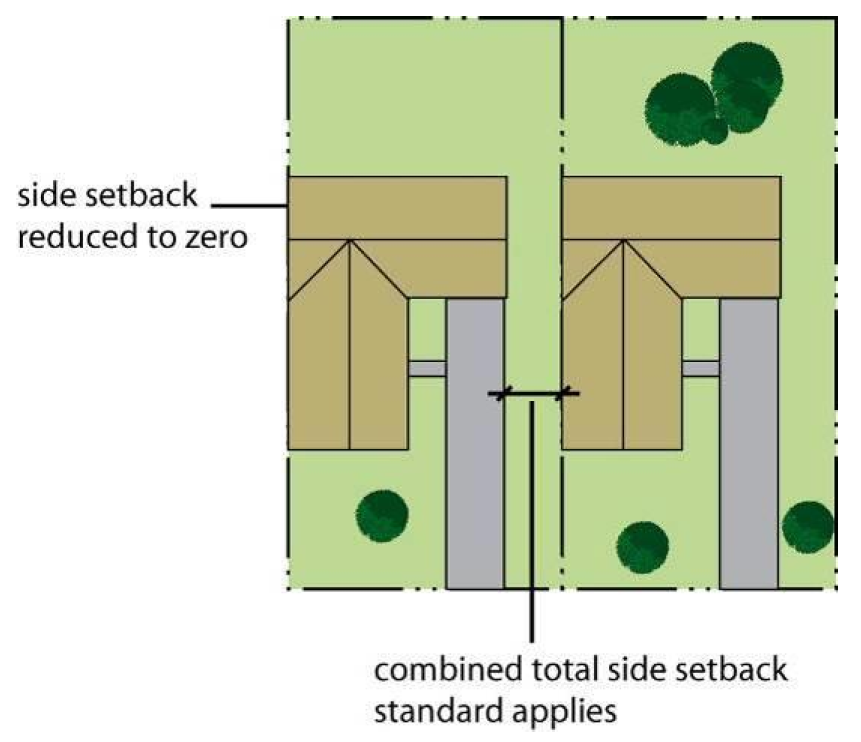
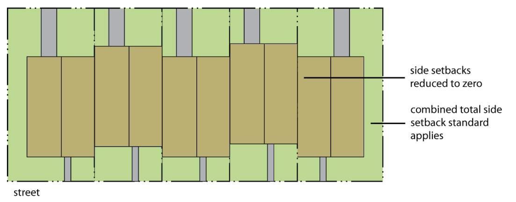
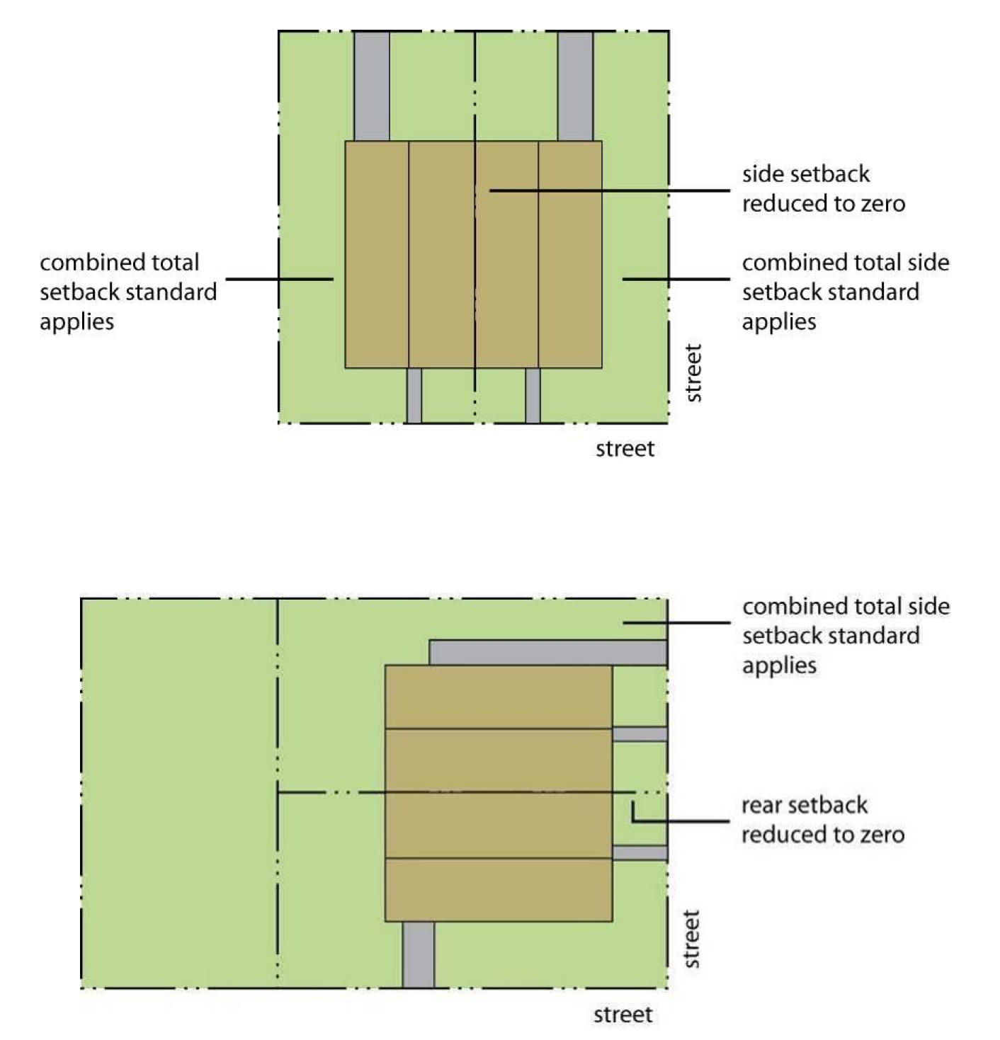
5-13-3
The side setback on one side of a lot line house may be reduced to zero. The minimum setback on the other side of the lot must equal at least two times the side setback standard of Section 5-11.
5-13-4
Eaves and other building projections on the side of a house with a reduced setback may not project over the abutting lot line unless: (a) an easement for the projection is obtained from the abutting owner and recorded with the Wake County Register of Deeds and (b) such projections are located at least nine feet above the ground.
5-13-5
When the exterior wall or eaves are set back less than two feet from the lot line, an easement must be obtained from the abutting owner and recorded with the Wake County Register of Deeds. The easement must ensure at least two feet of unobstructed space between the furthermost projection of the structure (including the eave) and the edge of the easement. This provision is intended to ensure the ability to conduct maintenance and upkeep activities on the lot line house.
5-13-6
Windows or other openings that allow for visibility into the side yard of the adjacent lot are allowed on lot line houses pursuant to compliance with the building code.
5-13-7
Lot line houses must be determined at the time of subdivision.
[Amended on 7/21/2008 by OA 02-08]
5-14 - Attached (single-family) Houses.
5-14-1
General. Attached (single-family) houses are allowed in accordance with the use table of Section 4-11.
(A)
All attached houses must comply with the lot and building standards that apply to the type of development (conventional or open space) in which such houses are located, except when those standards are expressly modified by the attached house standards of this section.
(B)
The common or abutting wall between attached units must be shared for at least 50 percent of the length of each unit.
(C)
No side setback is required for common or abutting walls.
(D)
On corner lots, either the rear setback or side setback may be reduced to zero. However, the remaining side or rear setback must comply with the conventional development lot and building standards of Section 5-11.
(E)
The minimum side setback standard of Section 5-11 applies along the sides of the building that do not have common or abutting walls.
5-14-2
Limitation on Number of Attached Units. When three or more units are attached, common access is required for access to rear-loaded parking area. Such access drives must be at least 12 feet wide if designed for one-way traffic and at least 20 feet wide if designed for two-way traffic.
[Amended on 11/21/2022 by OA-02-22]
5-20 - Conventional Development.
The following standards apply to all lots other than those located in approved open space developments (See Part 3 of this Article for rules governing measurement of and exceptions to these standards):
[1] Development in the RA district that uses one of the Alternative Development Options in accordance with Section 3-51-4, RA District Allowed Uses and Standards-Alternate Development Options, shall comply with the dimensional standards in this table. Development in the RA district that uses the Traditional Development Option in accordance with Section 3-51-3RA District Allowed Uses and Standards-Traditional Development Option shall comply with the standards in Section 3-51-3(B), Lot and Building Standards.
[2] Development that uses one of the Alternative Development Options in the RA district shall have a minimum lot width of 60 feet if the development is utilizing the Mixed Use Node (MUN) option, 25 feet if the development is using the Residential Neighborhood Development (RND) option, 100 feet if the development is using the New Enhanced Corporate Campus (ECC) option, and 150 feet if development is using the Redeveloped Enhance Corporate Campus (ECC) option.
[3] In some cases, more restrictive standards may apply to lots within the Swift Creek, Little River and Smith Creek Water Supply Watersheds. See Article 11, Part 3.
[4] Lots created after 7/01/2001 are subject to Wake County stormwater management regulations.
[5] Nitrogen export check required and is limited to 3.6 lbs./ac./yr. without best management practices or payments made to the N.C. Ecosystem Enhancement Program. Does not apply to nonresidential development in the R-80W and R-40W districts.
[6] Development that uses one of the Alternative Development Options in the RA district shall have a maximum building height of 300 feet if the development is utilizing the Mixed Use Node (MUN) option, 90 feet if the development is using the Residential Neighborhood Development (RND) option, and 160 feet if the development is using the Enhanced Corporate Campus (ECC) option.
[Amended of 1/22/2008 by OA 04-07; Amended on 11/21/2022 by OA-02-22; Amended on 6/16/2025 by OA-03-25]
5-30 - Setbacks.
The following setback standards and exceptions apply in all districts unless otherwise expressly stated.
5-30-1
General. Setbacks must be unobstructed from the ground to the sky except as expressly stated. Parking and driveways are allowed within required setbacks except where they conflict with required bufferyards or tree and vegetation protection zones. For definitions and illustrations of front, rear, side and corner setbacks, see Article 21.
5-30-2
Measurement from Ultimate Right-of-way. The minimum depth of a setback abutting a road must be measured from the edge of the ultimate right-of-way (as recommended in the Transportation Plan).
5-30-3
Features Allowed within Required Setbacks. In nonresidential districts, shelters such as canopies, awnings, and covered walkways, may be permitted in required setbacks up to half the width of the required setback, provided such structures in no way obstruct the line of sight along a thoroughfare. Features allowed within required setbacks are subject to applicable impervious surface limitations.
5-30-4
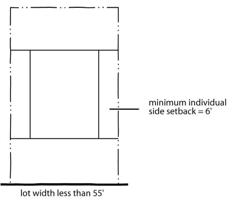
Side Setbacks on Narrow Lots. The following special side setback standards apply in residential districts to lots recorded in a plat or deed under one ownership on January 4, 1960:
(A)
On lots having an average width of less than 100 feet the combined total width of both side setbacks may be reduced to 30 percent of the lot width, and individual side setbacks may be reduced to ten percent of the lot width or eight feet, whichever is greater.
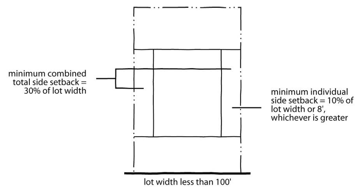
(B)
On lots having an average width of less than 55 feet, individual side setbacks may be reduced to six feet.
5-30-5
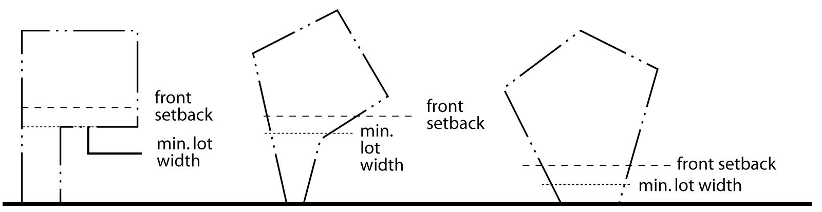
Setbacks on Irregularly Shaped Lots.
(A)
Purpose. Required setback distances are generally based on rectangular lots. Nonrectangular lots, lots with three sides or more than four sides and other irregularly shaped lots require special measurement techniques to ensure proper separation between structures and lot lines.
(B)
Front Setbacks. Front setbacks must be measured from the front property line unless the front property line does not meet the minimum lot width standard (as is the case on a flag lot), in which case the front setback must be measured from a point on the lot, nearest the front line, that complies with the minimum lot width standard of the subject zoning district. The Planning Director is authorized to establish the front property line and/or the front setback line in cases of uncertainty.
(C)
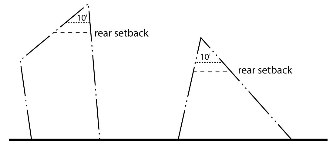
Rear Setbacks.
(1)
On irregularly shaped lots, the rear setback is measured from an imaginary line that:
(a)
Is within the lot;
(b)
Is drawn at a point most distant from the front property line where the lot is ten feet in width;
(c)
Is parallel to the front property line; and
(d)
Extends across the entire width of the lot.
(2)
The Planning Director is authorized to establish the rear setback line in cases of uncertainty.
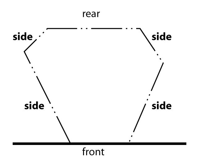
(D)
Side Setbacks. All property lines that are not front or rear property lines will be considered side property lines for purposes of measuring setbacks. The Planning Director is authorized to establish the rear setback line in cases of uncertainty.
5-40 - Thoroughfare Density Credits.
5-40-1
Intent. It is the intent of this section to encourage applicants for development approval to reserve or dedicate those undeveloped areas needed for proposed major thoroughfares by providing them density credits on those portions of their land or other properties that will not be needed for major thoroughfare construction.
5-40-2
Standards for Provision of Density Credits.
(A)
Scope. This section may apply to any parcel of land abutting or intersected by a proposed major thoroughfare which has been resolved by the Wake County Board of Commissioners as having county- or region-wide impact because of its traffic-carrying capacity and effect on the major thoroughfare system. Density credits may be provided for any residential use in any residential district.
(B)
Calculation of Density Credits.
(1)
To the extent that an applicant for a density credit dedicates or reserves undeveloped land for a proposed major thoroughfare as designated by the Wake County Board of Commissioners, an applicant may apply for density credits. Density credits are to be determined by calculating twice the maximum number of residential units that could have been constructed in the reserved or dedicated area under the zoning regulations then in effect.
(2)
In cases where the specific alignment of the major thoroughfare has not been determined, County staff must request such a determination from North Carolina Department of Transportation (NCDOT). Should NCDOT fail to make a determination in a timely manner, the Wake County Administration may determine the alignment.
(C)
Reservation or Dedication. As a condition to applying for density credits, the owner of land must:
(1)
Reserve land for the corridor which abuts or intersects the subject property and record in the office of the Wake County Register of Deeds sufficient legal documentation in the chain of title of the reserved land to evidence permanent alienation of development rights in that land; or
(2)
Dedicate land for the corridor that abuts or intersects the subject property to Wake County or the State of North Carolina, without any restrictions on its use.
5-40-3
Application of Density Credits. This density credit may be applied to increase the allowed density of any other land as provided herein.
(A)
Density credits may be applied to any tract of land located within the county's zoning jurisdiction, regardless of ownership, except land located within a water supply watershed.
(B)
In order to apply density credits to the same or different tracts, the application must be approved as a special use in accordance with the special use procedures Section 19-23.
(C)
By applying a density credit to a particular parcel, the owner or developer may increase the allowable density of uses by decreasing the size of the lot below that required in the district; however, in no case may density for the entire tract exceed 10,000 square feet per dwelling unit in all planning areas to which this subsection applies.
(D)
The owner of the density credits must apply for a special exception within five years of the date the land is reserved or dedicated. After this period, density credits become null and void.
5-40-4
Required Yards. The depth and width of all required yards and minimum lot widths may be reduced to correspond with those requirements for the zoning district with which the reduced lot size most closely complies. Should the development have lots sized between the minimum lot sizes of two districts, the requirements of the higher density district apply.
5-40-5
Maximum Lot Coverage Allowed. The maximum amount of a lot which may be covered with impervious surfaces after application of density credits may not exceed 50 percent.
5-41 - School Density Credits.
5-41-1
Intent. It is the intent of this section to encourage applicants for development approval to dedicate those undeveloped areas needed for proposed public school sites by providing them density credits on those portions of their land or other properties that will not be needed for major public school site construction.
5-41-2
Standards for Provision of Density Credits.
(A)
Scope. This section may apply to any parcel of land which is the proposed site of a school within the Wake County Public School System, as resolved by the Wake County Board of Education with the concurrence of the Wake County Board of Commissioners. Density credits may be provided for any residential use in any residential district.
(B)
Calculation of Density Credits. To the extent that an applicant for a density credit dedicates undeveloped land for a proposed public school site as designated by the Wake County Board of Education, with the concurrence of the Wake County Board of Commissioners, an applicant may apply for density credits. Density credits are to be determined by calculating twice the maximum number of residential units that could have been constructed in the dedicated area under the zoning regulations then in effect.
(C)
Reservation or Dedication. As a condition to applying for density credits, the owner of land must dedicate land for the school site to the Wake County Board of Education, without any restriction on its use.
5-41-3
Application of Density Credits. This density credit may be applied to increase the allowed density of any other land as provided herein.
(A)
Density credits may be applied to any tract of land located within the County's zoning jurisdiction regardless of ownership, except land located within a water supply watershed.
(B)
In order to apply density credits to the same or different tracts, the application must be approved in accordance with the special use procedures of Section 19-23.
(C)
By applying density credits to a particular parcel, the owner or developer may increase the allowable density of uses by decreasing the size of the lot below that required in the district; however, in no case may density for the entire tract exceed 12,000 square feet per dwelling unit in all planning areas to which this section applies.
(D)
The owner of the density credits must apply for a special use within five years of the date the land is dedicated. After this period, density credits become null and void.
5-41-4
Required Yards. The depth and width of all required yards and minimum lot widths may be reduced to correspond with those requirements for the zoning district with which the reduced lot size most closely complies. Should the development have lots sized between the minimum lot sizes of two districts, the requirements of the higher density district shall apply.
5-41-5
Maximum Lot Coverage Allowed. The maximum amount of a lot which may be covered with impervious surfaces after application of density credits shall not exceed 50 percent.
[Amended 6/7/2021 by OA-01-21].