
Wake County Unincorporated
City Zoning Code
City Zoning Code
ARTICLE 3
- Zoning Districts
3-10 - Districts Established.
The following zoning districts are established in this ordinance:
[Amended 1/22/2008 by OA 04-07; Amended 6/7/2021 by OA-01-21; Amended on 1/3/2022 by OA-03-21]
3-11 - Zoning Map.
3-11-1
The location and boundaries of zoning districts are as shown on a geographic coverage layer entitled "Zoning" that is maintained as part of the county's geographic information system (GIS) under the direction of the Planning Director. This "Zoning" geographic coverage layer, as amended in accordance with the provisions of Sec. 19-21, constitutes the official Wake County zoning map, and is as much a part of this ordinance as if depicted within the pages of this ordinance. The Planning Director must revise the official zoning map to reflect its amendment as soon as possible after the effective date of the amendment. No unauthorized person may alter or modify the official zoning map. The Planning Director may authorize printed copies of the official zoning map to be produced, and must maintain digital or printed copies of superseded versions of the official zoning map for historical reference.
3-11-2
Where the ordinance establishing a zoning boundary identifies the boundary as following a particular feature, or reflects a clear intent that the boundary follows the feature, the boundary will be construed as following that feature as it actually exists. The Planning Director must note any such relationship between a zoning boundary and other mapped feature on the zoning map when entering the zoning boundary.
3-11-3
Where any uncertainty exists about a zoning boundary, the actual location of the boundary will be determined using the following rules of interpretation:
(A)
A boundary shown on the zoning map as approximately following a river, stream, lake or other watercourse will be construed as following the actual centerline of the watercourse. If, subsequent to the establishment of the boundary, the centerline of the watercourse should move as a result of natural processes (flooding, erosion, sedimentation, etc.), the boundary will be construed as moving with the centerline of the watercourse.
(B)
A boundary shown on the zoning map as approximately following a ridge line or topographic contour line will be construed as following the actual ridge line or contour line. If, subsequent to the establishment of the boundary, the ridge line or contour line should move as a result of natural processes (erosion, slippage, subsidence, etc.), the boundary will be construed as moving with the ridge line or contour line.
(C)
A boundary shown on the zoning map as approximately following a lot line or parcel boundary will be construed as following the lot line or parcel boundary as it actually existed at the time the zoning boundary was established. If, subsequent to the establishment of the zoning boundary, the lot line or parcel boundary should be moved as a result of a minor property line adjustment (such as from settlement of a boundary dispute), the zoning boundary will be construed with moving with the lot line or parcel boundary only if the lot line or parcel boundary is moved no more than ten feet.
(D)
A boundary shown on the zoning map as approximately following a street or railroad line will be construed as following the centerline of the street or railroad right-of-way. If, subsequent to the establishment of the boundary, the centerline of the street or railroad right-of-way should be moved as a result of its widening or a minor realignment (such as at an intersection), the boundary will be construed with moving with the centerline only if the centerline is moved no more than 25 feet.
(E)
A boundary shown on the zoning map as approximately following the zoning jurisdiction boundary of an adjacent municipality will be construed as following that boundary as described in the ordinance or resolution establishing or extending the municipality's zoning jurisdiction (e.g., an annexation ordinance adopted by the municipality or a resolution adopted by the County Board of Commissioners granting the municipality extraterritorial jurisdiction).
(F)
A boundary shown on the zoning map as approximately parallel to, or as an apparent extension of, a feature described above will be construed as being actually parallel to, or an extension of, the feature.
(G)
If the specific location of the boundary cannot be determined from application of the above rules to the zoning map, it will be determined by scaling the mapped boundary's distance from other features shown on the map.
3-11-4
Where a certified field survey of one or more of the features described in Sec. 3-11-3 shows that a boundary is not accurately shown on the official zoning map, the Planning Director may authorize revisions to the zoning map necessary to make it accurate.
3-20 - Residential Watershed Districts.
3-20-1
Description.
(A)
The R-80W and R-40W zoning districts are known as residential watershed districts. These districts allow very-low-density residential development in the form of single-family detached dwellings and duplexes. A limited number of nonresidential uses are also allowed, but generally only if the Board of Adjustment first reviews and approves a site plan and Special Use Permit for such use.
(B)
Those proposing residential development in the residential watershed districts may elect to comply with the conventional development standards of Sec. 5-11 or the open space standards of Sec. 5-12.
[Amended on 11/21/2022 by OA-02-22]
3-20-2
Application. The residential watershed districts are intended to be applied to lands within the critical area of water supply watersheds (generally within ½ mile plus 300 feet of the water supply source's flood elevation). The district standards are intended to ensure that development occurs at intensities low enough to minimize pollution of the water supply source from stormwater runoff.
3-20-3
Allowed Uses. Principal uses are allowed in the residential watershed districts in accordance with the use table of Sec. 4-11.
3-20-4
Lot and Building Standards. Development in the residential watershed districts must comply with the lot and building standards of Article 5.
3-20-5
Other Watershed District-Related Regulations.
(A)
General. All development in residential watershed districts must, to the maximum extent practicable, minimize impervious surface coverage, direct stormwater away from surface waters, incorporate Best Management Practices (BMPs) to minimize water quality impacts, and transport stormwater runoff from the development by vegetated conveyances.
(B)
Water Supply Watershed Buffers. Any development in water supply watershed buffer areas is subject to the requirements of Article 11, Part 2 (Water Supply Watershed Buffers)
(C)
Stormwater Management.
(1)
For nonresidential development in R-80W districts, impervious surface coverage may not exceed six percent of the total area of the site, as designated on the site plan.
(2)
For nonresidential development in R-40W districts, on-site control of the first one-half inch of rainfall runoff from all impervious surfaces is required whenever impervious surface coverage exceeds 12 percent of the total area of the site, as designated on the site plan. Impervious surface coverage is limited to 24 percent of the total area of the site, as designated in the site plan, except in the Little River Water Supply Watershed, where impervious surface coverage may not exceed 12 percent of the total area of the site in accordance with the rules of the North Carolina Environmental Management Commission. Means of control must include, in order of preference, on-site infiltration, retention, or detention. Detailed written plans must be included in the project plans
(3)
Engineered stormwater control structures must meet design guidelines of the State Division of Water Quality, or its successor agency. Responsibility for maintenance of all permanent infiltration, retention, and detention control measures and facilities, after site development is completed, must lie with the owner of the use. When designed in accordance with the guidelines of the State Division of Water Quality, or its successor agency, lakes and ponds used singularly or in a system for stormwater runoff control may be included as a pervious surface for the purpose of calculating the impervious surface coverage of a site.
(4)
Other applicable state or county regulations may further restrict the development potential of a particular site (see, for example, Article 9).
(D)
Hazardous Materials.
(1)
Nonresidential Development.
(a)
In R-80W Districts, the use and storage of hazardous materials shall be prohibited.
(b)
In R-40W the use and storage of hazardous materials is permitted in accord with local, state, and federal legislation regulating the use and storage of hazardous materials.
(c)
In designated Water Supply Watershed Overlay districts, the use and storage of hazardous materials is permitted in accord with local, state, and federal legislation regulating the use and storage of hazardous materials.
(2)
Residential Development. The use and storage of hazardous materials is permitted in accord with local, state, and federal legislation regulating the use and storage of hazardous materials.
(E)
Requirements for Forestry Activities. Silvicultural activities in residential watershed districts are subject to the provisions of the Forest Practices Guidelines Related to Water Quality (15 NCAC 1I .0101-.0209), implemented by the State Division of Forest Resources, or its successor agency.
(F)
Prohibited Land Applications. Land application of residuals or petroleum-contaminated soils and the sale/storage of gasoline, kerosene and diesel fuel are prohibited in residential watershed districts.
3-20-6
Other Provisions of General Applicability. Development in the residential watershed districts is subject to all other applicable regulations of this ordinance, including the following:
(A)
Parking, Loading and Traffic. See Article 15 (Parking, Loading and Traffic).
(B)
Landscaping and Tree Protection. See Article 16 (Landscaping and Tree Protection).
(C)
General Site Design and Performance Standards. See Article 17 (General Site Design and Performance Standards).
(D)
Signs. See Article 18 (Signs).
[Amended on 7/21/2008 by OA 03-08]
3-21 - Non-Watershed Residential Districts.
3-21-1
Description. The R-80, R-40, R-30, R-20, R-15, R-10, and R-5 districts are known as non-watershed residential districts. These districts allow a range of very-low to moderate-density residential development and various building forms, depending on the specific district. A limited number of nonresidential uses are also allowed. Some nonresidential uses are permitted by-right; others are allowed only within designated multi-use districts and then only if the Board of Adjustment first reviews and approves a site plan and Special Use Permit for such use.
[Amended on 11/21/2022 by OA-02-22]
3-21-2
Application.
(A)
The R-80 districts are intended to be applied outside of water supply watersheds in areas designated in the Comprehensive Plan for residential development at densities of less than one dwelling unit per acre.
(B)
The R-40, R-30, R-20 and R-15 districts are intended to be applied outside of water supply watersheds in areas designated in the Comprehensive Plan for residential development at densities of one—four units per acre.
(C)
The R-10 district is intended to be applied outside of water supply watersheds in areas designated in the Comprehensive Plan for residential development at densities of four—eight units per acre.
(D)
The R-5 district is intended to be applied outside of water supply watersheds in areas designated in the Comprehensive Plan for residential development at densities of more than eight units per acre.
[Amended on 11/21/2022 by OA-02-22]
3-21-3
Allowed Uses. Principal uses are allowed in non-watershed residential districts in accordance with the use table of Sec. 4-11.
3-21-4
Lot and Building Standards. Development in non-watershed residential districts must comply with the lot and building standards of Article 5.
3-21-5
Other Provisions of General Applicability. Development in the non-watershed residential districts is subject to all other applicable regulations of this ordinance, including the following:
(A)
Parking, Loading and Traffic. See Article 15 (Parking, Loading and Traffic).
(B)
Landscaping and Tree Protection. See Article 16 (Landscaping and Tree Protection).
(C)
General Site Design and Performance Standards. See Article 17 (General Site Design and Performance Standards).
(D)
Signs. See Article 18 (Signs).
3-22 - Reserved for future use.
Editor's note— OA-03-21, adopted January 3, 2022, repealed § 3-22 which pertained to the RHC, Residential Highway Commercial District.
3-23 - HD, Highway District.
3-23-1
Description. The HD, Highway District is primarily intended to accommodate residential development, although it also allows several types of nonresidential development if the Board of Adjustment first reviews and approves a site plan and Special Use Permit for the use.
3-23-2
Purpose.
(A)
The interest of the public in its highways and major thoroughfares and the interests of the owners of adjacent lands are generally interdependent, but often in conflict. The efficiency, permanency, safety, and convenience, and enjoyment of such highways and major thoroughfares depend to a great extent upon the way such adjacent lands are utilized. On the other hand, the value of the adjacent lands, and the uses which can be made of them, depend to a great extent upon the continuation of the highway or thoroughfare and the amount and nature of the traffic upon it:
(1)
This District is adopted for the purposes of:
(a)
Protecting the public investment in and lengthening the time during which highways and major thoroughfares can continue to serve their functions of moving people and goods without expansion or relocation, by expediting the free flow of traffic and reducing the hazards arising from unnecessary points of ingress and egress and cluttered roadside development;
(b)
Requiring that buildings and structures be sufficiently set back from the right-of-way to provide adequate storage for vehicles until they can safely enter the flow of traffic;
(c)
Enhancing the value of adjacent lands by preserving and extending the useful life of the highway and thoroughfare systems, avoiding land uses that conflict with the roadside and the surrounding area, and reducing the risks of creating blighted areas as the result of future highway or thoroughfare relocations;
(d)
Ensuring the attractiveness of roadside uses, which will in turn contribute to and enhance trade, tourism, capital investment, and the general welfare; and
(e)
Reserving adequate roadside space through which neighborhood traffic may be admitted to and from the highway and thoroughfare system in a manner that avoids undue traffic concentrations, sudden turnings and stoppings, and other hazards.
(2)
The Highway District accomplishes the above purposes by:
(a)
Establishing more stringent regulation along major thoroughfares over the minimum width of building lots and depth of minimum front yards than are imposed along lesser roads and streets;
(b)
Prohibiting uses which involve a high number of traffic movements unless they are developed according to an approved site plan and certain standards which, together with certain incentives, are intended to encourage the clustering of such uses on one or more lots developed under one site plan and served by a common system of ingress and egress;
(c)
Requiring all yards to be landscaped, and limiting the uses which can be made of them;
(d)
Generally decreasing the number of points of ingress to, and egress from, such highway and thoroughfares, while increasing the separation between such points.
(B)
District Regulations.
(1)
Locational Criteria for Highway District. The County should utilize this District on lands adjacent to principal and minor arterials and selected portions of major collectors, as identified by the State Department of Transportation functional classification system, and interchanges with fully controlled access roads as determined appropriate for the types of uses which are allowed within it, and where there is or will be a need to exercise the types of regulations which are herein established in order to protect the public investment in such highways and the safety and convenience of the traveling public.
(2)
Recorded Lots. All lots recorded in the office of the Register of Deeds prior to the effective date of this Section are entitled to a permit for any General Use permitted in this District pursuant to receiving other necessary permits. Where the lot does not contain a minimum of 20,000 square feet, exclusive of required yards, the yard standards shall be modified in the following prescribed order so as to increase the lot coverage to a minimum of 20,000 square feet, exclusive of required yards:
(a)
Reduce the required rear yard up to a maximum of 40 percent and/or reduce the required side yard up to a maximum of 30 percent.
(b)
Reduce the required front yard up to a maximum of 30 percent.
3-23-3
Allowed Uses. Principal uses are allowed in the HD district in accordance with the use table of Section 4-11 (Use Table).
3-23-4
Lot and Building Standards. Development in the HD district must comply with the following lot and building standards.
(A)
Lot Width and Frontage Requirements for Special Uses. A lot on which a special use is to be located must have a width and road frontage width meeting the following standards:
(1)
Where direct access is to be provided from a thoroughfare, both the lot width and frontage width along the thoroughfare must each be at least 400 feet;
(2)
Where direct access is to be provided from an access road serving only two lots, both the lot width and frontage width along the access road must be at least 200 feet;
(3)
Where direct access is to be provided from an access road serving three or more lots, the lot width and frontage width along the access road must be at least 150 feet;
(4)
Where the lot fronts on a cul-de-sac road and is not a corner lot, the lot width along the cul-de-sac road must be at least 100 feet; and
(5)
Where the lot fronts on a rear access road but direct access is to be provided from a more minor thoroughfare, the lot width along the rear access road must be at least 100 feet.
(B)
Front and Corner Setbacks.
(1)
Special Uses. The minimum front/corner setback for special uses is 50 feet. Provided that the minimum depth of a yard abutting a major thoroughfare shall be measured from the edge of the thoroughfare's ultimate planned right-of-way (as determined from the Wake County Thoroughfare Plan).
(2)
Permitted Uses. The minimum front/corner setback for permitted uses is 30 feet.
(3)
Reductions for Special Uses. The Board of Adjustment, in considering an application for a special use, may reduce the building setback lines and minimum front yard requirements upon making a finding that the proposed reduction of those requirements:
(a)
Will not substantially defeat the purposes for which those requirements were established, as set forth in Article 19 (Review and Approval Procedures) of this Unified Development Ordinance;
(b)
Will not adversely affect traffic conditions in the vicinity by, for example, impeding sight lines at street intersections and curb cuts; and
(c)
Is necessitated by the configuration of the land, which makes it impossible to comply with the standard setback and front yard requirements.
(C)
Side Setbacks.
(1)
Special Uses.
(a)
Minimum width of side yard of corner lot: Fifty feet, provided that the minimum depth of a yard abutting a major thoroughfare shall be measured from the edge of the thoroughfare's ultimate planned right-of-way (as determined from the Wake County Thoroughfare Plan).
(b)
Minimum width of one side yard: Thirty feet; but 50 feet when adjacent to a Residential District.
(c)
Minimum aggregate width of side yards: Eighty feet; but 50 feet when one side yard abuts a railroad track.
(d)
A minimum side or rear yard is not required when a railroad siding located on or along a lot line serves two adjacent lots.
(2)
Permitted Uses. The minimum side setback for permitted uses is ten feet.
(3)
Abutting Railroad Rights-of-Way. A minimum side setback is not required when a railroad line is located on or along a lot line.
(4)
Reductions for Special Uses. The Board of Adjustment, in considering an application for a special use, may reduce the building setback lines and minimum side yard requirements upon making a finding that the proposed reduction of those requirements:
(a)
Will not substantially defeat the purposes for which those requirements were established, as set forth in Article 19 (Review and Approval Procedures) of this Unified Development Ordinance;
(b)
Will not adversely affect traffic conditions in the vicinity by, for example, impeding sight lines at street intersections and curb cuts; and
(c)
Is necessitated by the configuration of the land, which makes it impossible to comply with the standard setback and front yard requirements.
(D)
Rear Setbacks.
(1)
Special Uses. Minimum depth of rear yard: Forty feet; but 50 feet when adjacent to a public right-of-way or residential district, provided that the minimum depth of a yard abutting a major thoroughfare shall be measured from the edge of the thoroughfare's ultimate planned right-of-way (as determined from the Wake County Thoroughfare Plan).
(2)
Permitted Uses. The minimum rear setback for permitted uses is 30 feet.
(3)
Abutting Railroad Rights-of-Way. A minimum rear setback is not required when a railroad line is located on or along a lot line.
(4)
Reductions for Special Uses. The Board of Adjustment, in considering an application for a special use, may reduce the building setback lines and minimum rear yard requirements upon making a finding that the proposed reduction of those requirements:
(a)
Will not substantially defeat the purposes for which those requirements were established, as set forth in Article 19 (Review and Approval Procedures) of this Unified Development Ordinance;
(b)
Will not adversely affect traffic conditions in the vicinity by, for example, impeding sight lines at street intersections and curb cuts; and
(c)
Is necessitated by the configuration of the land, which makes it impossible to comply with the standard setback and front yard requirements.
(E)
Setback Usage.
(1)
For General and Special Uses.
(a)
Sediment impoundments, boundary fences, gates, and security stations may be located in any required yard.
(b)
Accessory buildings are only permitted in a maximum of 50 percent of the required side and rear yards provided that:
i.
No accessory building shall be located in front of the front building line; and
ii.
No accessory building shall be located closer than 50 feet to a corner side yard lot line, or 20 feet to a side or rear yard lot line.
(c)
Parking and loading shall not be permitted in any required front yard or corner side yard, nor within 20 feet of any lot line in any other required yard area.
(2)
For Special Uses Only.
(a)
Accessory uses—other than necessary driveway and railroad crossings—the outdoor storage, display, and dispensing of goods and services are prohibited within any required side or rear yard abutting a public right-of-way, residential district, or major thoroughfare, but are permitted within any other required side or rear yard, provided they are located at least 20 feet from the side or rear lot line.
(b)
Those portions of the front, rear, side, or corner side yards that are not devoted to the uses, buildings, and structures that are permitted within this Section shall be landscaped in accordance with the regulations as set forth in Article 16 of this Unified Development Ordinance.
(c)
Screening and fencing: The Board of Adjustment may require a screen or fence to be provided in all or any part of those yards where there is outdoor storage or display of materials, outdoor recreation; accessory building(s), or parking. In order to require a screen or fence, the Board of Adjustment must make a finding that such yard usage would not be essential to the operation of the proposed use, or that such usage would be unsightly when viewed from an adjacent zoning district or public thoroughfare.
(F)
Points of Ingress and Egress for Permitted and Special Uses.
(1)
To and From Adjacent Highway or Thoroughfare. Each building lot is limited to one point of ingress to, and one point of egress from, the adjacent highway or thoroughfare. Points of ingress and egress may be combined into one two-way driveway with appropriate separation of lanes. Additional points of ingress to and egress from a highway or thoroughfare are not allowed unless necessary to improve traffic movement or safety, increase sight distances, or for similar reasons.
(2)
Corner Lots. Ingress to and egress from a corner lot or lots may be limited to the more minor thoroughfare and are prohibited within 200 feet of the intersection along the thoroughfare unless no other alternative exists. Ingress to and egress from reverse frontage lots are limited to the more minor thoroughfare.
(3)
To and From Access or Reverse Frontage Roads. No restrictions are placed upon the number of points of ingress and egress between a lot or lots and a private access or reverse frontage road. If such roads are dedicated to the public, the number of points of ingress and egress that are allowed must be determined by the governmental agency or body having the authority to accept the road.
(4)
Standards. All points of ingress and egress and access roads and reverse frontage roads must be designed, constructed, and maintained according to sound engineering principles and any applicable standards of the North Carolina Department of Transportation.
(5)
Joint Ingress and Egress. If the owners of two or more lots jointly provide a direct point of both ingress and egress, or an access or reverse frontage road, to serve their lots, adequate provisions must be made by dedication, covenants, restrictions, or legal instruments for ensuring that such points of ingress and egress on such roads are provided and maintained consistent with the regulations and intent of this section.
(6)
Spacing Standards.
(a)
Purpose. The spacing standards of this section are intended to improve the compatibility of roadside uses with adjacent thoroughfares by ensuring the separation and proper location of points of ingress and egress.
(b)
Thoroughfares. The spacing requirements for lots with direct points of ingress and egress to thoroughfares:
i.
For lots with permitted uses, a minimum of 100 feet; and
ii.
For lots with special uses, a minimum of 200 feet.
(c)
Measurement. The spacing requirements of this section must be measured from the centerlines of the nearest points of ingress and egress; and the spacing of direct points of ingress and egress for different lots must be spaced as evenly as possible.
(d)
Reductions due to hardship. Where topography, line of sight distances, vegetation, geological formations, or other site characteristics are such that strict adherence to spacing dimensions would impose unnecessary hardship upon the permit applicant or undue hazard to the motoring public, the Planning Director or Board of Adjustment may authorize a decrease in the spacing dimensions of up to 20 percent, provided that a record of why such a decrease is necessary is made a part of the permit.
(7)
Paving of Entrance for Special Uses. All points of ingress and egress and all access roads which serve lots for special uses must be paved for at least the first 50 feet nearest to the thoroughfare to which it connects.
3-23-5
Other District-Specific Regulations.
(A)
Impervious Surface Coverage.
(1)
For residential uses, the total impervious surface coverage of any lot or parcel may not exceed 30 percent of the area of that lot or parcel except for lots within open space subdivisions, where this impervious surface coverage limit must be increased by a percentage equal to the percentage of the subdivision site dedicated or reserved as permanent open space. NOTE: other state and/or county regulations may impose stricter limits.
(2)
For nonresidential uses, the total impervious surface coverage of any lot or parcel may exceed 30 percent of the area of that lot or parcel only if on-site detention of storm water is provided for the runoff in excess of that which would occur with 30 percent impervious surface coverage. NOTE: other state and/or county regulations may impose stricter limits.
(B)
Additional Special Use Standards. No use requiring a discharge permit, or engaged in the manufacture, processing, or storage of chemicals, toxic materials, or petroleum products in solid or liquid form, are permitted within a water supply watershed.
(C)
Operational Performance Standards. All permitted and special uses must comply with the operational performance standards of Section 17-11 (Operational Performance Standards).
(D)
Multiple Uses of Buildings and Lots.
(1)
If both permitted and special uses are located on the same lot, the lot must comply with the minimum lot width and other regulations for special uses.
(2)
Unless this ordinance expressly provides otherwise, only one principal building or structure may be located on a building lot, but each building or structure may contain more than one dwelling unit or principal use, subject to compliance with all other applicable standards.
(3)
If ingress to and egress from a lot or lots is provided by an access road or reverse frontage road, one or more principal buildings or structures may be located on the lot or lots as provided in an approved site plan and Special Use Permit; and each building or structure may contain one or more dwelling units or principal uses as provided in subparagraph (D)2. However, no permit will be issued unless the applicant submits evidence showing sufficient control over the lot or lots to ensure compliance with the approved site plan.
(E)
Off-Street Parking. Each lot must provide off-street parking in accordance with Article 15 (Parking, Loading and Traffic).
(F)
Bufferyards. Bufferyards must be established and maintained in accordance with the standards of Article 16 (Landscaping and Tree Protection). Where width of the bufferyard required by Article 16 (Landscaping and Tree Protection) exceeds the setback depth required by Article 5 (Lot and Building Standards), the bufferyard standards of Article 16 (Landscaping and Tree Protection) govern.
[Amended on 11/21/2022 by OA-02-22]
3-23-6
Other Provisions of General Applicability. Development in the HD district is subject to all other applicable regulations of this ordinance, including the following:
(A)
Parking, Loading and Traffic. See Article 15 (Parking, Loading and Traffic).
(B)
Landscaping and Tree Protection. See Article 16 (Landscaping and Tree Protection).
(C)
General Site Design and Performance Standards. See Article 17 (General Site Design and Performance Standards).
(D)
Signs. See Article 18 (Signs).
[Amended on 1/22/2008 by OA 04-07]
3-24 - RMH, Residential Mobile Homes District.
3-24-1
Purpose.
(A)
The RMH, Residential Mobile Homes district is intended to provide the public with an opportunity to utilize mobile home housing in a prescribed environment conducive to public health, safety, welfare, and convenience.
(B)
The RMH district is intended to be applied in a manner that is compatible with the character of existing development of surrounding properties, thus ensuring the continued conservation of building values and encouraging the most appropriate use of land in the county.
3-24-2
Allowed Uses. Principal uses are allowed in the RMH district in accordance with the use table of Section 4-11 (Use Table).
3-24-3
Lot and Building Standards. Development in the RMH district must comply with the following lot and building standards.
3-24-4
Other District-Specific Regulations.
(A)
Impervious Surface. The maximum lot coverage by total impervious surfaces will be determined as follows:
(1)
Any additional runoff resulting from lot coverage in excess of 30 percent must be detained in on-site detention or retention facilities. The minimum capacity of these facilities must be such that the stormwater discharge may not exceed that expected before development from the impervious portion in excess of 30 percent for the following frequency storms:
(2)
Runoff estimates must be calculated by the method described in USDA Soil Conservation Technical Release Number 55, Urban Hydrology for Small Watersheds, or by methods utilized and recommended by the Director of Environmental Services.
(B)
Site Plan Requirements. No use permit or building permit will be issued until a detailed site plan, written and illustrated, has been submitted to and approved by the Planning Director. The site plan and associated documentation must clearly describe or illustrate means of compliance with all applicable standards of this ordinance.
(C)
One Mobile Home per Space. Only one mobile home may be parked on any mobile home space at one time. Recreational vehicles, or other similar vehicles that are not intended for permanent habitation are not considered mobile home units.
(D)
Mobile Home Space Surfacing. The surface of each mobile home stand or pad must be graded for proper drainage and must be covered by a paved slab or by compacted earth, gravel, or stone.
(E)
Ground Cover. In order to control erosion, all disturbed land areas must be protected by a vegetative ground cover.
(F)
Streets; Access.
(1)
All streets within a mobile home park must be paved. Through streets connecting two public thoroughfares or extending to adjacent properties must be built to the minimum construction standards required by the State Department of Transportation for acceptance to the State Highway System. All streets must be identified by names approved by the Planning Director.
(2)
In addition, the following regulations apply to every mobile home park:
(a)
Each mobile home space must abut upon an improved street or driveway which must have unobstructed access to a public thoroughfare.
(b)
With the exception of through streets described in subparagraph 1 above, every street must comply with the "Class A" private road standards of Sec. 8-32-5.
(G)
Off-Street Parking. Each mobile home space must have off-street parking facilities for two vehicles.
(H)
No Direct Access to Thoroughfare Outside Park. No mobile home space may have direct vehicular access to any thoroughfare other than those thoroughfares located within the mobile home park.
(I)
Maximum Cul-de-sac Length. The cul-de-sac length standards of Sec. 8-32-17 apply to mobile home parks.
(J)
State Approval of Ingress and Egress. Plans for ingress to and egress from each mobile home park must be approved by the State Department of Transportation.
(K)
Bufferyards.
(1)
Bufferyards must be established and maintained in accordance with the standards of Sec. 16-10-2. Where width of the bufferyard required by Sec. 16-10-2 exceeds the setback depth required by Sec. 3-24-3, the bufferyard standards of Sec. 16-10-2 govern.
(2)
In order to eliminate visual distractions to passing motorists, reduce levels of noise, dust, or glare, preserve the character of existing neighborhoods, and in other ways serve the purposes of zoning as set forth in Section 160D-701 of the General Statutes, mobile home parks must be screened from adjacent highways and from existing adjoining conventional residential developments in accordance with Sec. 16-10.
(L)
Recreation Areas and Facilities.
(1)
Adequate and suitable recreation and open space areas must be provided to serve the anticipated population and must consist of at least 10,000 square feet per 25 mobile homes. In addition, when the anticipated population includes children, suitable facilities must be provided as shown in the following table:
(2)
For mobile home parks with less than 25 homes, the minimum size facilities shown in the preceding table is required. No recreation facilities may be placed in an area utilized for septic tank filter fields.
(M)
Accessory Uses in Mobile Home Parks.
(1)
Service buildings and areas necessary to provide laundry, sanitation, storage, vending machines, and other similar services provided by the facility operator for the use and convenience of mobile home tenants.
(2)
Recreation buildings and areas serving only the mobile home park in which they are located.
(3)
Customary accessory buildings and facilities necessary for operation of the mobile home park in which they are located.
(4)
Storage buildings (no larger than 12 feet by 12 feet in base, and ten feet in height) for individual mobile home spaces.
(5)
Fenced communal storage areas provided by the park operator for boats, campers, and other accessory vehicles belonging to park residents.
(6)
Child care centers as shown on the approved park plan, and child care homes, as an accessory use to a mobile home park and intended to principally serve the child care needs of mobile home park residents.
(N)
Sanitary Facilities, Water Supply, Garbage Collection, and Utilities. In every mobile home park, all utility installations must comply with applicable building and health codes of the county and the state, and the requirements of the State Utilities Commission.
(1)
Utilities; Mobile Home Stand. Each mobile home stand must be equipped with water and wastewater connections.
(2)
Mobile Home Equipment. Each mobile home must be connected to utilities provided at each mobile home space.
(3)
Road Lights. A lighting system must be installed within each mobile home park.
(4)
Water Supply. Each mobile home park must obtain water from either a public water supply or a source approved by the Department of Health and Human Services, the State Department of Environmental Quality, or successor agencies. The water supply and pressure must be adequate for the park requirements.
(5)
Sewage and Refuse Disposal. Each mobile home park must be provided with an adequate sewage disposal system, either by connection to a public wastewater system or to a system constructed in compliance with the regulations of the Department of Health and Human Services, the State Department of Health and Human Services, or successor agencies.
(6)
Garbage Disposal. All garbage and refuse in each mobile home park must be stored in suitable waterproof and rodent-proof receptacles, which must be kept covered with tightly fitting lids. All garbage and refuse must be regularly disposed of in a sanitary manner acceptable to the Department of Environmental Services, Department of Health and Human Services or successor agency.
3-24-5
Other Provisions of General Applicability. Development in the RMH district is subject to all other applicable regulations of this ordinance, including the following:
(A)
Parking, Loading and Traffic. See Article 15 (Parking, Loading and Traffic).
(B)
Landscaping and Tree Protection. See Article 16 (Landscaping and Tree Protection).
(C)
General Site Design and Performance Standards. See Article 17 (General Site Design and Performance Standards).
(D)
Signs. See Article 18 (Signs).
[Amended on 1/22/2008 by OA 04-07; Amended 6/7/2021 by OA-01-21; Amended on 11/18/2024 by OA-01-24]
3-30 - O&I, Office and Institutional District.
3-30-1
Description. The O&I, Office and Institutional district is intended to accommodate institutional, office and limited commercial activities that are less intensive than other commercial districts. In addition, the O&I district may serve as an appropriate transitional zoning district between residential districts and other (non-O&I) commercial districts.
3-30-2
Allowed Uses. Principal uses are allowed in the O&I district in accordance with the use table of Sec. 4-11.
3-30-3
Lot and Building Standards. Development in the O&I district must comply with the lot and building standards of Article 5.
3-30-4
Other District-Specific Regulations.
(A)
Parking. Parking is not permitted in any required side setback.
(B)
Utilities. Approval of water supply and sewage disposal plants by the County or State agencies having jurisdiction of such facilities over the land to be developed will be required before the issuance of use or building permits.
(C)
Operational Performance Standards. All business uses must be carried on in such a manner as to produce no offensive noise, dirt, odor, glare, heat, or vibration perceptible or measurable outside the subject property lines.
3-30-5
Other Provisions of General Applicability. Development in the O&I district is subject to all other applicable regulations of this ordinance, including the following:
(A)
Parking, Loading and Traffic. See Article 15 (Parking, Loading and Traffic).
(B)
Landscaping and Tree Protection. See Article 16 (Landscaping and Tree Protection).
(C)
General Site Design and Performance Standards. See Article 17 (General Site Design and Performance Standards).
(D)
Signs. See Article 18 (Signs).
3-31 - GB, General Business District.
3-31-1
Description. The GB, General Business district is established to provide for a wide variety of (primarily indoor) neighborhood- and community-oriented commercial activities. Allowable uses within the General Business district include, but are not limited to, educational, cultural, daycare, religious, animal care, restaurant, financial, lodging, office, general retail, vehicular sales and service uses.
3-31-2
Allowed Uses. Principal uses are allowed in the GB district in accordance with the use table of Sec. 4-11.
3-31-3
Lot and Building Standards. Development in the GB district must comply with the lot and building standards of Article 5.
3-31-4
Other District-Specific Regulations.
(A)
Operational Performance Standards. All business uses must be carried on in such a manner as to produce no offensive noise, dirt, odor, glare, heat, or vibration perceptible or measurable outside the subject property lines.
3-31-5
Other Provisions of General Applicability. Development in the GB district is subject to all other applicable regulations of this ordinance, including the following:
(A)
Parking, Loading and Traffic. See Article 15 (Parking, Loading and Traffic).
(B)
Landscaping and Tree Protection. See Article 16 (Landscaping and Tree Protection).
(C)
General Site Design and Performance Standards. See Article 17 (General Site Design and Performance Standards).
(D)
Signs. See Article 18 (Signs).
3-32 - HC, Heavy Commercial District.
3-32-1
Description. The HC, Heavy Commercial district is established to provide for a wide variety of (indoor and outdoor) commercial activities of varying scales that are designed to be served by major thoroughfares. It is the intent of this district to provide sufficient size and depth of property to meet business needs, yet maintain safe traffic flows. Allowable uses within the HC district include, but are not limited to, educational, cultural, daycare, religious, animal care, restaurant, financial, lodging, office, general and specialized retail, vehicular sales and service, limited/light manufacturing, wholesale, warehouse uses.
3-32-2
Allowed Uses. Principal uses are allowed in the HC district in accordance with the use table of Sec. 4-11.
3-32-3
Lot and Building Standards. Development in the HC district must comply with the lot and building standards of Article 5.
3-32-4
Other District-Specific Regulations.
(A)
Operational Performance Standards. All business uses must be carried on in such a manner as to produce no offensive noise, dirt, odor, glare, heat, or vibration perceptible or measurable outside the subject property lines.
3-32-5
Other Provisions of General Applicability. Development in the HC district is subject to all other applicable regulations of this ordinance, including the following:
(A)
Parking, Loading and Traffic. See Article 15 (Parking, Loading and Traffic).
(B)
Landscaping and Tree Protection. See Article 16 (Landscaping and Tree Protection).
(C)
General Site Design and Performance Standards. See Article 17 (General Site Design and Performance Standards).
(D)
Signs. See Article 18 (Signs).
3-40 - I-1, Industrial-1 District.
3-40-1
Description. The I-1 district is established to provide for a wide range of manufacturing, warehousing, and wholesaling activities as well as offices and some commercial support services. Standards of this district are designed to minimize impacts on the environment and to help ensure visual compatibility with the surrounding area. The district is intended to accommodate uses whose operations, exposure, location and traffic have minimal impacts on adjacent properties. These uses include, but are not limited to, correctional, animal care, restaurant, office, vehicle sales and service, all levels of manufacturing, mining, warehouse, wholesale, freight handling, and waste related uses. Use- related outdoor storage is allowed only if it is screened by a solid fence, or by an opaque vegetative screen, of at least six feet in height.
3-40-2
Allowed Uses. Principal uses are allowed in the I-1 district in accordance with the use table of Sec. 4-11.
3-40-3
Lot and Building Standards. Development in the I-1 district must comply with the lot and building standards of Article 5.
3-40-4
Other District-Specific Regulations.
(A)
Operational Performance Standards. All uses developed within Industrial districts must comply with the operational performance standards of Sec. 17-11.
3-40-5
Other Provisions of General Applicability. Development in the I-1 district is subject to all other applicable regulations of this ordinance, including the following:
(A)
Parking, Loading and Traffic. See Article 15 (Parking, Loading and Traffic).
(B)
Landscaping and Tree Protection. See Article 16 (Landscaping and Tree Protection).
(C)
General Site Design and Performance Standards. See Article 17 (General Site Design and Performance Standards).
(D)
Signs. See Article 18 (Signs).
[Amended on 1/3/2022 by OA-03-21]
3-41 - I-2, Industrial-2 District.
3-41-1
Description. The I-2 district is established in order to provide sites for manufacturing, warehousing, and wholesaling activities (including outdoor storage of material) that have a greater impact on the surrounding area than uses found in the I-1 district. It is the intent of this district to protect high-intensity manufacturing uses from nearby residential development and vice-versa. It is also the intent to provide a zoning classification for uses with high potential for adverse visual impacts. These uses include, but are not limited to, correctional, animal care, restaurant, office, vehicle sales and service, all levels of manufacturing, mining, warehouse, wholesale, freight handling, and waste related uses.
3-41-2
Allowed Uses. Principal uses are allowed in the I-2 district in accordance with the use table of Sec. 4-11.
3-41-3
Lot and Building Standards. Development in the I-2 district must comply with the lot and building standards of Article 5.
3-41-4
Other District-Specific Regulations.
(A)
Operational Performance Standards. All uses developed within Industrial districts must comply with the operational performance standards of Sec. 17-11.
3-41-5
Other Provisions of General Applicability. Development in the I-2 district is subject to all other applicable regulations of this ordinance, including the following:
(A)
Parking, Loading and Traffic. See Article 15 (Parking, Loading and Traffic).
(B)
Landscaping and Tree Protection. See Article 16 (Landscaping and Tree Protection).
(C)
General Site Design and Performance Standards. See Article 17 (General Site Design and Performance Standards).
(D)
Signs. See Article 18 (Signs).
[Amended on 1/3/2022 by OA-03-21]
3-50 - AD-1 and AD-2, Airport Districts.
3-50-1
Purpose; Locational Criteria.
(A)
The AD-1, Airport 1 district is intended to:
(1)
Incorporate the intent of Airport 2 district (AD-2) regulations listed in paragraph (F), below;
(2)
Ensure the attractiveness of roadside uses, which will, in turn, contribute to and enhance trade, tourism, capital investment, and the general welfare; and
(3)
Enhance the efficiency, safety, convenience, and enjoyment of thoroughfares within Airport districts by controlling the type and design of land uses allowed thereon.
(B)
The AD-2, Airport 2 district is intended to:
(1)
Limit land uses in Airport districts to nonresidential uses;
(2)
Confine, to the extent possible, land in these districts to industrial, commercial, agricultural, or recreational uses which are not subject to high population concentrations;
(3)
Ensure that such uses are located, designed, constructed, and maintained in a manner compatible with Airport district uses;
(4)
Protect the public from annoyance by aircraft noise, especially jet noises;
(5)
Protect the public from danger of falling aircraft; and
(6)
Provide for those uses that are not appropriate for thoroughfares, but which are otherwise suitable Airport district uses.
(C)
AD-1 and AD-2 districts should encompass land subjected to specified and measurable amounts of aircraft noise associated with runway configurations.
(D)
The AD-1 district is intended for those lands subjected to specified airport noise levels that are adjacent to selected interstate highways, principal and minor arterial roads, and designated portions of collector roads, as defined by the State Department of Transportation functional classification system. Accordingly, the AD-1 district will also include those lands adjacent to U.S. 70, Interstate 40, S.R. 1839, S.R. 1002 between U.S. 70 and Interstate 40, and S.R. 3015 between S.R. 1002 and Interstate 40, within the Airport districts.
(E)
These regulations do not apply to bona fide farms, but any use of farm property for non-farm purposes is subject to the regulations.
(F)
The following regulations apply in both Airport districts. Wherever the Zoning Regulations of Raleigh-Durham Airport Authority impose more stringent standards than are required by the regulations made under authority of this ordinance, the provisions of the Zoning Regulations for Raleigh-Durham Airport Authority will govern.
Commentary: Under authority granted by state statutes, the Raleigh-Durham Airport Authority exercises exclusive zoning authority over all lands within the Raleigh-Durham International Airport.
3-50-2
Allowed Uses. Principal uses are allowed in the AD-1 and AD-2 districts in accordance with the use table of Sec. 4-11.
3-50-3
Special Uses.
(A)
Municipal solid waste landfills, subject to the provisions of subsection Sec. 4-49;
(B)
Mining operations, subject to the provisions of subsection Sec. 4-48.
3-50-4
Lot and Building Standards. Unless otherwise indicated, the provisions of this section apply to uses in both Airport districts.
(A)
Lot Design Standards. The following standards apply in A-I and A-II districts:
(1)
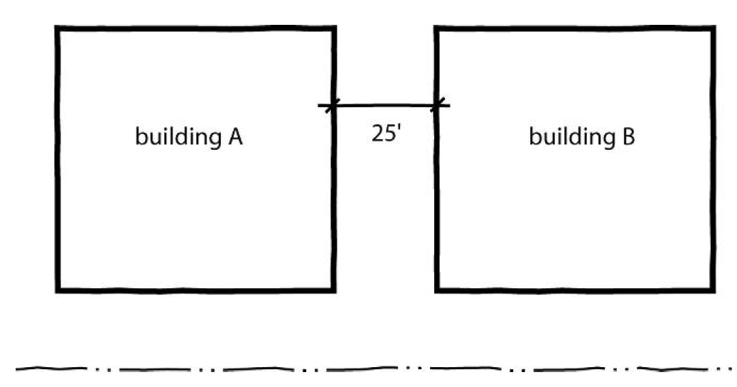
Minimum Building Separation: Twenty-five feet
(2)
Minimum Front and Corner Setbacks: Fifty feet
(3)
Minimum Side Setback: none when abutting railroad; Fifty feet when abutting public right-of-way; none in all other cases
(4)
Minimum Rear Setback: none when abutting railroad; Fifty feet when abutting public right-of-way; none in all other cases
3-50-5
Other District-Specific Regulations.
(A)
Parking.
(1)
Parking areas for customers or employees, sidewalks, and shelters (such as canopies, awnings, or covered walkways) are permitted within required setbacks, and may occupy up to half of the depth or width of the required setback, provided such structures in no way obstruct the line of sight along a thoroughfare.
(2)
Off-street parking and loading spaces of sufficient number to provide for vehicles customarily parked or used in conjunction with each building or use must be provided on each lot, pursuant to Article 15. All parking areas must be so located and designed that ingress and egress is by forward motion of the vehicle.
(3)
Within Airport district I only, overnight parking areas for heavy equipment, mobile homes, or trailers must be located at least 50 feet from the right-of-way boundary of any thoroughfare.
(B)
Utility Requirements. Approval of water supply and sewage disposal plans by the Department of Health and Human Services or State agency having jurisdiction over the site is required prior to the issuance of any Land Use Permit.
(C)
Accessory Buildings and Uses. Within both Airport districts, buildings and uses of land customarily accessory to the principal land uses are permitted, pursuant to Article 4, Part 7. However, within the AD-1 district, accessory buildings or structures must be located at least 50 feet from the right-of-way boundary of any thoroughfare.
(D)
Bufferyards. Bufferyards must be established and maintained in accordance with the standards of Sec. 16-10-2. Where width of the bufferyard required by Sec. 16-10-2 exceeds the setback depth required by Sec. 3-50-4, the bufferyard standards of Sec. 16-10-2 govern.
(E)
Lighting Requirements. All outdoor lighting must be shielded in such a manner that no direct glare from the light source can be seen from above. This restriction does not apply to warning lights such as those installed in towers, tall buildings, etc., to mark obstructions to aircraft. A lighting plan must be approved by the Planning Director.
(F)
Bulk Storage of Flammable Substances and Hazardous Materials.
(1)
The bulk storage of a flammable liquid or gas, or hazardous material whose release could pose a threat to the public health, is allowed only as an accessory use to a permitted principal use, and only where such substance is necessary to the normal operations of the principal use. "Tank farms," gasoline or fuel distribution centers, warehousing of explosives, and similar facilities for bulk storage of such substances as a principal use are prohibited.
(2)
Any aboveground storage facility for such substances must:
(a)
Be located outside of an airport's runway protection zone, as defined by the Federal Aviation Administration (FAA) for the category of airport;
(b)
Be located to conform to FAA standards for the setback of structures from the sides of airport runways;
(c)
Be in a location that has been found acceptable from an aeronautics standpoint by an Obstruction Evaluation Study performed by the FAA; and
(d)
Be located, designed, and operated to conform to all applicable State Building Codes and all fire codes.
(G)
Regulation of Outside Activities in Airport District I.
(1)
When located within 500 feet of a right-of-way boundary of any thoroughfare in the AD-1 district, the following activities must be entirely enclosed by a building:
(a)
Bulk material or machinery storage;
(b)
Salvage of used materials or junk; and
(c)
Asphalt or concrete mixing plants.
(2)
In addition, within the AD-1 district, yard areas used for the sale or storage of building materials must be enclosed or must be covered by canopies, where such yards are located within 500 feet of any right-of-way boundary of any thoroughfare.
[Amended on 6/4/2012 by OA 02-12; Amended on 11/18/2024 by OA-01-24]
3-51 - RA, Research Applications District.[1]
3-51-1
Purpose.
(A)
The purpose of the RA, Research Applications district is to accommodate new development and redevelopment in the Research Triangle Park (RTP) that supports the RTP's mission of business and scientific research and development, training, and production of prototype products.
(B)
This is accomplished through the establishment of several development options that allow a broad range of uses and varied densities and intensities of development that support the RTP's mission.
3-51-2
Overview of RA District Regulations. The RA district regulations allow development as follows.
(A)
In accordance with the RA district regulations in Section 3-51-3, RA District Allowed Uses and Standards—Traditional Development Option; or
(B)
As one of three Alternate Development Options in accordance with Section 3-51-4, RA District Allowed Uses and Standards—Alternate Development Options.
3-51-3
RA District Allowed Uses and Standards—Traditional Development Option. The allowed uses and district standards that apply to the Traditional Development Option in the RA district are as follows.
(A)
Allowed Uses.
(1)
Principal Uses. The principal uses permitted in the RA district are those uses listed in Section 4-11, Use Table.
(2)
Accessory Uses.
(a)
If designated as being considered part of an abutting lot for purposes of applying certain provisions of the Traditional Development Option, a natural area preserve must also be considered part of the abutting lot for purposes of permitting the following uses as accessory to the lot's principal use: driveways; walkways; service utility facilities; outdoor recreation facilities; signs and lighting devices; landscaping; and gates or security stations.
(b)
The Traditional Development Option may include natural area preserves - that is, a parcel of land primarily intended to function as permanent open space providing environmental, scenic, or recreational benefits to adjacent development, and which has been designated as such on a recorded plat. If the recorded plat designates any portion of the natural area preserve as providing permanent open space to the benefit of an abutting lot, that portion of the natural area preserve must be considered as part of the abutting lot for purposes of applying the maximum lot coverage and minimum setback provisions in subsection (B) below, and the sign regulations in Article 18 to development of the abutting lot.
(B)
Lot and Building Standards. The following lot and building standards apply under the Traditional Development Option:
(1)
Minimum Lot Width: 300 feet
(2)
Maximum Lot Coverage: No more than 30 percent of the total area of a lot may be covered by buildings, driveways, parking areas and loading areas.
(3)
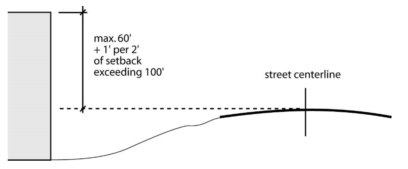
Maximum Building Height: One hundred twenty feet, can go up to 145 feet with Special Use approval, except when the building site is located in a Special Highway Overlay District, in which case the height limit is 60 feet above the centerline elevation of the adjacent road plus one foot of additional height for each two feet of building setback exceeding 100 feet. These height limits do not apply if the effect would be to limit the building's height to less than 60 feet above the highest finished grade at the building's foundation.
(4)
Minimum Required Setbacks:
(a)
One hundred feet abutting right-of-way.
(b)
One hundred feet setback for side and rear yards.
(c)
If so designated, an abutting natural preserve area may be counted as part of the lot for purposes of applying these minimum setback requirements, provided that all structures are set back at least 30 feet from the natural preserve area.
(C)
Other District—Specific Regulations
(1)
Storage. Outside storage of any materials, supplies or products is not permitted within any required setback area, and further, outside storage areas must be located, constructed, or landscaped to not be visible from any other lot or public street right-of-way.
(2)
Environmental Standards. All development must comply with applicable federal and State requirements and regulations with regard to dust, smoke, odors, noise, air and water pollutant emissions, hazardous waste, solid wastes, radioactive wastes, ionizing radiation, radioactivity, and sewage and industrial wastes.
(3)
Glare. Glare, whether direct or reflected, such as from floodlights or high temperature processes, and as differentiated from general illumination, may not be visible at any property line.
(4)
Exterior Lighting. Any lights used for exterior illumination must direct light away from adjoining properties, and must be designed or sited so that the lighting source is not visible from adjoining properties. A lighting plan may be required by the Planning Director.
(5)
Radio Frequencies. Any radio frequency may not adversely affect any operations or any equipment other than those of the emitter of the frequency. Avoidance of adverse effects from radio frequency generation by appropriate single or mutual scheduling of operations is permitted.
(6)
Waste. All sewage and industrial wastes must be treated and disposed of in such manner to comply with the wastewater ordinances and requirements of the Town of Cary and the State of North Carolina.
(D)
Parking and Loading.
(1)
The minimum off-street parking schedule in Section 15-10-4 shall not apply to development in the RA district.
(2)
Notwithstanding any other provisions or standards contained in this section, parking areas of sufficient size to provide parking for patrons, customers, suppliers, visitors, and employees shall be provided on the premises of each use. Parking areas shall be paved with an all-weather surface, and shall provide for stormwater drainage. Surface parking lots designed primarily for use by employees shall be located, constructed, or landscaped so as to be minimally visible from any other lot or public street right-of-way.
(3)
Loading areas for supplies and services shall be sufficient to meet the requirements of each use. Loading areas, except railroad loading areas, shall be located, constructed, or landscaped so as to be minimally visible from any other lot or public street right-of-way.
(E)
Exceptions to Minimum Setback Requirements
(1)
Abutting Railroads. Notwithstanding the provisions in this section, no minimum setback is required abutting the right-of-way of a railroad track or siding.
(2)
Structures Allowed within Required Setbacks. The following structures are allowed within required setbacks to the extent indicated:
(a)
Structures below and covered by the ground;
(b)
Steps and walkways;
(c)
Driveways;
(d)
Signs and lighting devices;
(e)
Planters, retaining walls, fences, fountains, park tables and seating, hedges, and other landscaping structures;
(f)
Gate or security stations;
(g)
Roof overhangs; and
(h)
Utility lines located underground and minor structures accessory to utility lines (such as hydrants, manholes, and transformers and other cabinet structures).
(3)
If a natural area preserve is considered part of the lot for purposes of applying the minimum setback requirements in subsection (B) above, these exclusions also apply to that portion of the preserve located within the required setback area.
(4)
Use of Required Setbacks. Except for structures allowed within required setbacks by subsection (B) above, the area of required setbacks must be either retained and maintained in a natural state or landscaped and maintained as attractive natural areas that include lawns, wooded areas, decorative planting, outdoor recreation areas, and/or water surfaces.
(5)
Natural Area Preserves. The district may include natural area preserves, that is, a parcel of land primarily intended to function as permanent open space providing environmental, scenic, or recreational benefits to adjacent development, and which has been designated as such on a recorded plat. If the recorded plat designates any portion of the natural area preserve as providing permanent open space to the benefit of an abutting lot, that portion of the natural area preserve must be considered as part of the abutting lot for purposes of applying the maximum lot coverage and minimum setback provisions in subsection (B) above, and the sign regulations in Section 18-12-1, Research Applications Districts, to development of the abutting lot.
3-51-4
RA District Allowed Uses and Standards—Alternate Development Options. There are three Alternate Development Options in the RA district.
(A)
Mixed-Use Node (MUN) Option.
(1)
Accommodates high density/intensity development that embodies key elements of walkable urbanism, including, but not limited to, walkable and bikeable areas that are well-connected to the regional transportation network through a range of transit options.
(2)
Accommodates a mix of uses including research and development, offices, retail, entertainment, public and quasi-public uses, and limited moderate and higher density residential uses.
(3)
Promotes the establishment of a strong public realm of sidewalks, pedestrian ways, trails, streets, and open spaces that support a pedestrian-friendly environment with focal points for engagement.
(4)
Encourages the vertical mixing of uses. The horizontal mixing of stand-alone uses is also allowed, provided the development is well-integrated in terms of complementary uses, access and circulation, and compatible design.
(B)
Residential Neighborhood Development (RND) Option.
(1)
Accommodates traditional neighborhood development, in limited instances and at appropriate locations, in a compact form and with a neighborhood center (and potentially sub-centers).
(2)
Includes primarily residential development (with a range of housing options), and a mix of additional uses (including neighborhood supporting retail uses and civic uses).
(3)
Ensures the establishment of a strong public realm that is human-scale and pedestrian-oriented, with integrated open space and recreational opportunities.
(C)
Enhanced Corporate Campus (ECC) Option.
(1)
Accommodates the expansion and redevelopment of the existing corporate campuses in the RTP, or the development of new corporate campuses, in a form that allows for a broader mix of uses and greater densities/intensities than is allowed under the RA district regulations for the Traditional Development Option.
(2)
The allowed uses include research and development, offices, retail, eating and drinking establishments, and recreational uses.
(3)
Encourages horizontal and vertical mixed-use development.
(4)
Requires the redeveloped or new ECC include improved pedestrian and street connections between existing and new buildings, enhanced walkability and pedestrian-friendliness, support the RTP's multimodal transportation plan, improve street connections both internal and external to the campus, and maintain a reasonable amount of open space.
(5)
Requires redevelopment to infill the existing development site.
(D)
Approval Procedures. Development plans in RA district zoning shall be submitted in accordance with Section 19-42. Submittals must include: 1) a letter from the Research Triangle Foundation (RTF) indicating which development option is selected and that all development standards subject to review and approval by RTF have been satisfied; and 2) documentation from the water and sewer utility provider indicating intent to provide service to the development.
(E)
Allowed Uses. The uses permitted in the RA district for development of one of the Alternate Development Options are those uses listed as permitted in the RA district in Section 4-11, Use Table, except that:
(1)
The use standards that apply to principal uses in Section 4-30 through 4-69 do not apply to the Alternate Development Options.
(2)
The use standards that apply to accessory uses in Sections 4-70 through 4-79, and temporary uses in Sections 4-80 through 4-88, do not apply to the Alternate Development Options.
(F)
Development Standards.
(1)
General Development Standards Applicable to All Alternate Development Options. All development in the RA district that develops as either a MUN, RND, or ECC Alternate Development Option shall comply with the following standards.
(a)
Streets.
(i)
All streets shall be reviewed and approved by the RTF for consistency with the classifications and standards within the covenants, conditions, and restrictions managed by RTF that encumber land in the RA district.
(ii)
Streets that are publicly dedicated shall be reviewed and approved by the NC Department of Transportation.
(b)
Parking and Loading.
(i)
Minimum and Maximum Off-Street Vehicular Parking. There is no minimum or maximum amount of off-street vehicular parking required for an Alternate Development Option.
(ii)
Parking Lot Design Standards. When included as part of an Alternate Development Option, parking lots and spaces shall comply with the standards in Section 15-10-10, Design Standards, and Section 16-10-1, Off-street Parking Lot Landscaping.
(iii)
Traffic Impact Analyses. Development in an Alternate Development Option shall comply with the traffic impact analyses requirements of Section 15-12, Traffic Impact Analyses.
(iv)
Vehicular Stacking. An Alternate Development Option shall comply with the vehicular stacking requirements of Section 15-10-4, Off-street Parking Schedule.
(v)
Loading Areas. Loading areas shall comply with Section 15-11, Off-Street Loading.
(c)
Landscaping and Buffering.
(i)
General. An Alternate Development Option shall comply with the following sections in Article 16, Landscaping and Tree Protection, but are exempt from all other sections in Article 16:
(a)
Section 16-10-1, Off-Street Parking Area Landscaping.
(b)
Section 16-10-2, Bufferyards, but only on parcels within 150 feet of the perimeter of the RA district adjacent to parcels in Wake County.
(c)
Section 16-10-3, Plant Material, Installation and Maintenance.
(d)
Section 16-11, Trash Storage Area Screening.
(e)
Section 16-12-8, Tree Protection During Construction.
(d)
Exterior Lighting.
(i)
All exterior lighting shall be shielded or directed away from any adjacent use or lot or adjacent public street.
(ii)
No exterior lighting shall cause illumination in excess of one foot candle at the lot line of any use at the perimeter of the RA district adjacent to parcels within Wake County.
(e)
Signage. The signage regulations in Article 18, Signs, only apply to development that utilizes one of the Alternate Development Options if the sign is within 150 feet of the perimeter of the RA district.
(f)
Subdivision Design and Improvements. Each Alternate Development Option shall comply with Article 8, Subdivision Design and Improvements.
(g)
Stormwater Management. Each Alternate Development Option shall comply with Article 9, Stormwater Management.
(h)
Other Environmental and Erosion Control Standards. Each Alternate Development Option shall comply with the following:
(i)
Article 10, Erosion and Sedimentation Control.
(ii)
Article 11, Environmental Standards.
(iii)
Article 12, Water and Wastewater System.
(iv)
Article 14, Flood Hazard Areas.
(i)
General Site Design and Performance Standards. Each Alternate Development Option shall comply with Article 17, General Site Design and Performance Standards, except for Section 17-12, Trash Storage Area Requirements and Section 17-11-7, Exterior Lighting.
(2)
Additional Standards Applicable to Mixed-Use Nodes (MUN). Development that uses the MUN Alternate Development Option shall comply with the applicable standards in Section 5-20, Conventional Development.
(3)
Additional Standards Applicable to Residential Neighborhood Development (RND). Development that uses the RND Alternate Development Option shall comply with the applicable standards in Section 5-20, Conventional Development.
(4)
Additional Standards that Apply to a Redeveloped ECC Alternate Development Option. Development that uses the Redeveloped ECC Alternate Development Option shall comply with the applicable standards in Section 5-20, Conventional Development.
(5)
Additional Standards that Apply to the New ECC Alternate Development Option. Development that uses the New ECC Alternate Development Option shall comply with the applicable standards in Section 5-20, Conventional Development.
[Adopted 6/16/2025 by OA-03-25]
Editor's note—Res. No. OA-03-25, adopted June 16, 2025, repealed § 3-51 and enacted a new § 3-51 as set out herein. Former § 3-51 pertained to similar subject matter.
3-52 - PD, Planned Development District.
3-52-1
Purpose. The PD, Planned Development district is intended to permit the establishment of areas in which diverse uses may be combined and integrated through careful planning to provide a unified and compatible development which is consistent with the general comprehensive plan, and which may reasonably be expected to result in a quality of living environment which is more closely in keeping with the purposes of zoning than would otherwise likely be obtained. It is not the intent of the Board of Commissioners that the PD district become a "loophole" designed to permit otherwise illegal contract, conditional or spot zoning, or the clandestine institution of the unlawful use variance. Rather, the PD district is intended to permit further refinement and more detailed expression of the general comprehensive plan in situations where the owners of the property present a development plan which is found to be in the public interest and consistent with the general comprehensive plan.
3-52-2
Approval Procedure. Planned developments require review and approval in accordance with the procedures of Sec. 19-24.
3-52-3
Allowed Uses. The uses allowed in a PD district must be established at the time of plan approval.
3-52-4
Lot and Building Standards. The lot and building standards that apply in a PD district must be established at the time of plan approval.
3-52-5
Other Provisions of General Applicability. Development in the PD district is subject to all other applicable regulations of this ordinance, including the following, unless otherwise expressly approved in accordance with the PD approval procedures of Sec. 19-24:
(A)
Parking, Loading and Traffic. See Article 15 (Parking, Loading and Traffic).
(B)
Landscaping and Tree Protection. See Article 16 (Landscaping and Tree Protection).
(C)
General Site Design and Performance Standards. See Article 17 (General Site Design and Performance Standards).
(D)
Signs. See Article 18 (Signs).
3-53 - CMU and RMU, Mixed-Use Districts.
3-53-1
Purpose.
(A)
There are two types of Mixed-Use zoning districts—the Classic Mixed-Use district, which must be located within a multi-use district as designated on the Wake County Comprehensive Plan and the Residential Mixed-Use district, which is not required to be within a designated multi-use district. The Classic Mixed-Use Development zoning district is intended to help implement the Wake County Comprehensive Plan in Municipal Transition Areas by encouraging a mixture of residential and commercial uses in a single development, while the Residential Mixed-Use district is intended to encourage residential developments with a mix of housing types and unit sizes.
(B)
Classic Mixed-Use districts (CMU) are intended to provide a rich mix of residential, shopping, employment and recreational uses and be surrounded by residential areas adequate in size and population to help support the nonresidential uses within designated multi-use districts. A design feature that helps ensure multi-use districts and residential support areas are compatible in terms of land use type and density is transitional development. Design guidelines for multi-use districts place an emphasis on achieving safe and efficient access to thoroughfares, highly connected roads and paths, and visual compatibility of development within the multi-use districts with surrounding residential areas.
(C)
Residential Mixed-Use districts (RMU) are intended to encourage unified residential developments that offer a mix of housing types such as apartments, condominiums, townhouses and/or single-family detached homes. This will provide a range of housing opportunities to a diversified economic group while creating a sense of a unified neighborhood.
[Amended on 11/21/2022 by OA-02-22]
3-53-2
Approval Procedure.

(A)
Process Generally. Requests to establish a Classic Mixed-Use district (CMU) or a Residential Mixed-use district (RMU) must first be determined to be consistent with the Wake County Comprehensive Plan. Once a consistency determination has been made, the application to establish a Mixed-Use district or a Residential Mixed-Use district must include the following:
(1)
An application for rezoning to the CMU or RMU district; and
(2)
A Concept Plan for the subject property, which must be processed concurrently with the rezoning application.
(B)
Pre-Application Meeting. Before filing an application for CMU or RMU zoning, applicants must schedule and attend a pre-application conference with Planning Department staff.
(C)
Required Contents of a Concept Plan. Concept Plans must address the general density, mix of uses (or housing types), and the development patterns within the proposed development. The intent is to provide sufficient information to determine consistency with the spirit and intent of the multi-use district objectives, policies and design guidelines in the Wake County Comprehensive Plan. Minimum requirements for Concept Plans include:
(1)
Location and size of the property proposed for development;
(2)
Proposed gross density of the mixed-use development, including the maximum number of dwelling units and gross floor area of nonresidential uses;
(3)
A general concept plan showing major and minor transportation corridors and pedestrian linkages throughout the area proposed for development, including appropriate linkages within the project and between the proposed project and adjacent areas;
(4)
Generalized categories of land uses proposed including approximate total percentages of land area and general locations devoted to residential, office, commercial, and institutional uses;
(5)
Specifications for the buffering/screening around the perimeter of the mixed-use development, as well as between internal components of the mixed-use development;
(6)
A written report on how the plan complies with the Comprehensive Plan's design guidelines;
(7)
Plans for providing centralized water and wastewater service, or public water and sewer service, to the property; and
(8)
A traffic impact analysis, if required pursuant to Sec. 15-12.
(D)
Approval Criteria for Concept Plans. Proposed Concept Plans must be reviewed for compliance with the following approval criteria:
(1)
CMUs and RMUs must be consistent with the requirements of this section;
(2)
CMUs must include an appropriate mix of land uses for the overall multi-use district, based on the multi-use district polices of the Comprehensive Plan;
(3)
CMUs must be consistent with multi-use district design guidelines of the Comprehensive Plan;
(4)
RMUs are encouraged to include a mix of housing types, including moderate- or higher-density housing;
(5)
RMUs must comply with the allowable densities as defined in the relevant Area Land Use Plans.
(6)
CMUs and RMUs must provide some outdoor open space for public use, such as a park, village green, or plaza.
(7)
CMUs and RMUs must be compatible with the use and value of adjoining properties.
(E)
Effect of Approval.
(1)
Once CMU (or RMU) zoning and the accompanying Concept Plan have been approved by the Board of County Commissioners, all subsequent site and/or subdivision plans submitted within the boundaries of the subject mixed-use district must be consistent with the terms of the approved Concept Plan for that district.
(2)
Except as expressly approved as part of the Concept Plan, all development within the CMU (or RMU) district is subject to compliance with all applicable standards of this ordinance.
(3)
The approval of a Concept Plan will not become effective until the applicant has submitted a copy of the final Concept Plan incorporating all changes that were required as conditions of the Board of County Commissioners' approval.
(4)
Upon receipt of the revised Concept Plan, the Planning Director must verify the incorporation of the changes, sign the plan "approved" and provide a signed copy of the plan to the applicant. The original must be retained for the records of the Planning Department. The County may require additional copies of the approved Concept Plan to aid other County Departments or outside agencies in their review of the subsequent site and/or subdivision plans.
(F)
Concurrent Processing of Plans. An application for Concept Plan approval and any application for site and/or subdivision plan approval may be filed and processed simultaneously, provided that review and decision-making bodies must render separate recommendations and decisions on each application.
(G)
Changes to Approved CMU or RMU Districts. The boundaries of a CMU or RMU district may be amended by following the same procedure required for establishment of CMU or RMU zoning. Major modifications of approved Concept Plans will also be processed in the same manner as new applications for CMU or RMU zoning. Minor technical modifications that pose no potential for adverse impacts on surrounding properties or developed portions of a CMU or RMU district may be approved at the time of site plan or subdivision plan review.
(H)
Duration of Approved CMU or RMU Districts. There is no expiration date for CMU or RMU districts once the rezoning has been approved by the Board of Commissioners, however, any subsequent site and/or subdivision approvals are subject to the time limitations established elsewhere in this ordinance.
[Amended on 11/21/2022 by OA-02-22]
3-53-3
Minimum Land Area. The minimum land area for a CMU or a RMU district is 25 acres, or 25 percent of the land area of the multi-use district, whichever is less.
[Amended on 11/21/2022 by OA-02-22]
3-53-4
Allowed Uses.
(A)
The uses allowed in a CMU district must be established at the time of Concept Plan approval.
(B)
Allowed uses must be consistent with the multi-use district policies of the Wake County Comprehensive Plan.
(C)
A CMU district must include a mix of residential and nonresidential uses. Residential uses must occupy at least 25 percent of the gross floor area or gross acreage of the project. Higher density residential development is encouraged, such as multi-family, traditional neighborhood development, or dwellings over shops. Building permits may not be issued for more than 50 percent of the commercial floor area until Certificates of Occupancy have been issued for at least 25 percent of the residential units, unless the entire development is comprised of one building.
(D)
The residential mix of housing types, general size ranges of residential units, and overall density and its dispersal pattern throughout the development must be established at the time of Concept Plan approval in an RMU district.
(E)
An RMU district, that is located outside of a multi-use district, may contain up to 20,000 square feet of nonresidential building space that will be used for neighborhood supporting functions such as, but not limited to, a convenience store, restaurant, or other low-impact uses. To help ensure that these facilities serve only the immediate neighborhood, they must comply with the following criteria:
(1)
Be located at least one-quarter of a mile (1,320 feet) from the thoroughfare(s) adjacent to the perimeter of the mixed-use development;
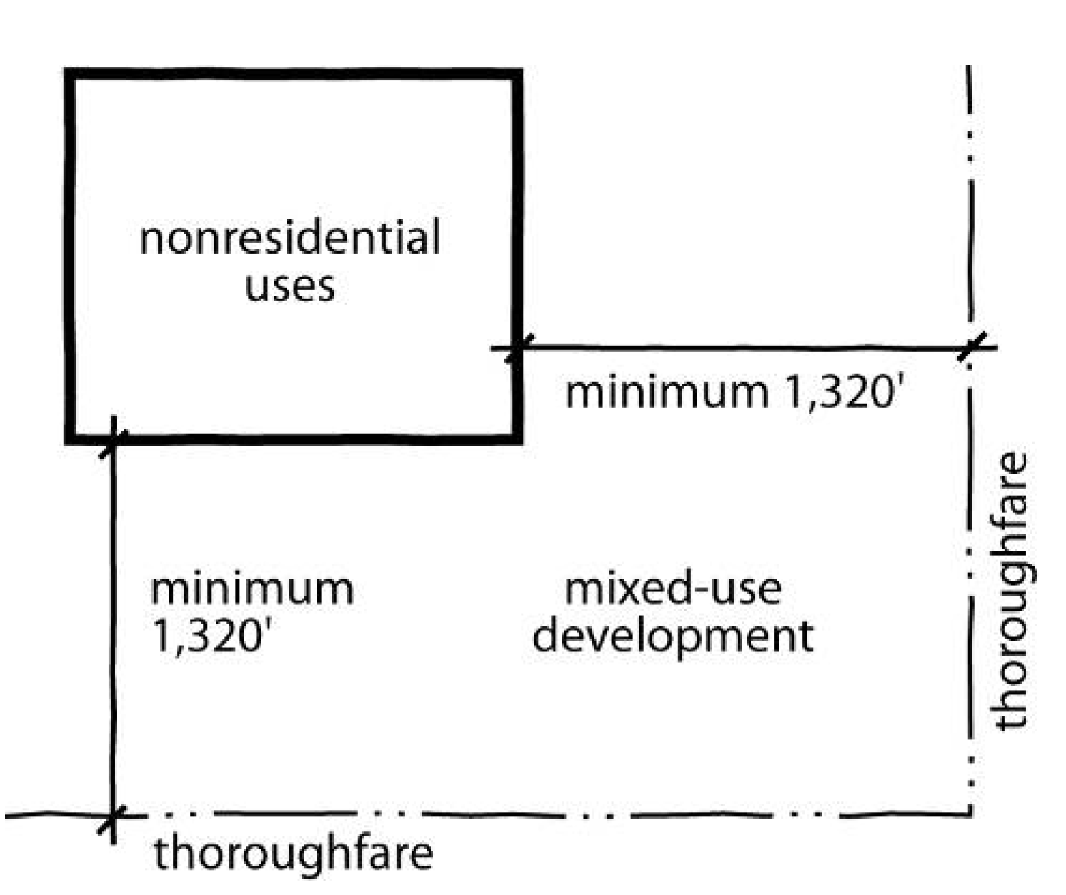
(2)
Prohibit the posting of any signage along the thoroughfare(s) adjacent to the perimeter of the mixed-use development;
(3)
Provide only one-half of the number of parking spaces that would normally be required for the specific use(s) in an effort to encourage pedestrian or bicycle usage.
[Amended on 11/21/2022 by OA-02-22]
3-53-5
Lot and Building Standards. The following lot and building standards apply in CMU and RMU districts:
(A)
Urban Areas. Within areas of the county designated as Municipal Transition Areas by the Wake County Comprehensive Plan Development Framework Map, residential development within a CMU or an RMU district may be approved at densities not to exceed the density levels allowed in the Residential-5 (R-5) zoning classification. The lot and building standards applicable to the Heavy Commercial (HC) district apply in such areas unless otherwise specified at the time of Concept Plan approval. Furthermore, the Concept Plan must specify, at a minimum, the following regulatory standards:
(1)
The maximum height, number of stories, and size of buildings and other structures;
(2)
The maximum percentage of individual lots and the site as a whole that may be covered with impervious surfaces (as determined by all state and local-watershed and stormwater regulations);
(3)
The minimum size and dimensions of yards and open spaces;
(4)
The maximum density allowed/proposed;
(5)
The location and use of all buildings, structures, and land;
(6)
The proposed number and location of parking spaces;
(7)
The proposed internal screening between uses (external screening must comply with the applicable general ordinance provisions); and
(8)
Any additional information deemed appropriate by the Planning Director, Planning Board and/or the Board of Commissioners.
[Amended on 11/21/2022 by OA-02-22]
3-53-6
Design Guidelines. The design guidelines of this section are to be used in evaluating Concept Plans:
(A)
Access to Thoroughfares.
(1)
Access points onto thoroughfares should have sight distances that are adequate to permit safe stopping of vehicles. Minimum sight-distances are as established by the American Association of State Highway Traffic Officials (AASHTO), or as otherwise approved by the North Carolina Department of Transportation:
(2)
Access points should be located adequate distances (at least 400 feet) from thoroughfare intersections and from other access points to permit safe and efficient traffic flows. Where this separation is unachievable due to parcel dimensions or natural constraints, access points should be as far away as practicable from intersections and other access points. Vehicular full access turning motions will be considered on a case-by-case basis.
(3)
Each lot should be limited to one point of access to an adjacent thoroughfare, for each 400 feet of lot frontage. Access points should be combined to serve multiple lots or uses whenever practicable.
(4)
Turning lanes or deceleration lanes to NCDOT standards should be installed along abutting thoroughfares.
(5)
All thoroughfare improvements must conform to the requirements of the Transportation Plan, any required Traffic Impact Analysis, and/or NCDOT.
(B)
Connectivity.
(1)
The site design should, to the maximum extent practicable, conform to the following activity center design criteria:
(a)
Provide parking areas to the side or rear of buildings out of view of roadways and residential areas;
(b)
Maximize the connection of interior access drives or streets within the project with surrounding streets, projects, or subdivisions;
(c)
Encourage the use of alleys;
(d)
Include pedestrian access that connects the project with residential areas within, or adjacent to, the project; and
(e)
Provide connections to any existing or planned greenway within or adjacent to the project.
(C)
Building Architecture and Materials.
(1)
Buildings should include windows or doors for each story (upper story windows may be real or faux) visible from a residential district or public right-of-way.
(2)
A residential scale and proportion is encouraged in neighborhood multi-use districts. The mass of buildings may be de-emphasized in a variety of ways including varied facades or projecting or recessed sections to reduce apparent bulk. Such breaks in facades should occur at least every 50 feet of building length.
(3)
There should be solid screening for all mechanical equipment, electrical equipment, plumbing vents, ducts or other utility structures that will be visible from a public road or residential district.
(4)
The county's historic preservation ordinance and guidelines supersede these guidelines where applicable.
(D)
Landscaping.
(1)
Existing trees and vegetation should be saved whenever practicable. Isolated stands of trees should be preserved and incorporated into the site design.
(2)
Foundation landscaping, including grass and trees or shrubs/hedge plants, should be provided along building fronts and sides.
(E)
Signs.
(1)
A unified sign plan must be developed and approved by the Planning Department that identifies the locations, common or coordinated themes, colors, and materials for all proposed signage.
(2)
Lighting impacts of signs should be minimized. Signs legible from residential districts or public roads should not include flashing lights, strings of lights, or beacons. Signs cannot be internally illuminated.
(3)
Freestanding ground signs should not exceed eight feet in height and 32 square feet in area per side. Smaller signs (four feet in height and eight square feet in area per side) are preferred where they can accommodate the sign's message. No pole signs are allowed. Only one sign is allowed per road frontage of the development.
(4)
Building signs (including wall and projection signs) should be no taller than the lower eave line or roofline, and should project from the building no more than four feet. Their surface area should not exceed five percent of the total area of the building facade(s) on which the signs are located.
[Amended on 11/21/2022 by OA-02-22]
3-53-7
Other Provisions of General Applicability. Development in the CMU and RMU districts is subject to all other applicable regulations of this ordinance, including the following:
(A)
Parking, Loading and Traffic. See Article 15 (Parking, Loading and Traffic).
(B)
Landscaping and Tree Protection. See Article 16 (Landscaping and Tree Protection).
(C)
General Site Design and Performance Standards. See Article 17 (General Site Design and Performance Standards).
(D)
Signs. See Article 18 (Signs).
[OA 05/07 November 7, 2005]
3-60 - Description.
Each conditional zoning district bears a "CZ" prefix and corresponds to a general use district. General use districts include all residential, commercial, and industrial districts without a "CZ" prefix. All zoning regulations that apply in the general use district are minimum requirements within the corresponding conditional zoning district. Conditional zoning will be considered only upon request of the applicant.
[Amended 6/7/2021 by OA-01-21].
3-70 - General.
3-70-1
Overlay districts are overlaid on general zoning district classifications to alter some or all of the underlying district regulations in order to address special situations or accomplish specific planning or zoning goals.
3-70-2
Overlay district regulations apply in combination with underlying general zoning district regulations and all other applicable standards of this ordinance.
3-70-3
When overlay district standards conflict with standards that otherwise apply in the underlying district, the regulations of the overlay district always govern.
3-70-4
Unless otherwise expressly stated, all applicable regulations of the underlying district apply to property in an overlay district.
3-71 - SHOD, Special Highway Overlay District.
3-71-1
Purpose and Intent.
(A)
The SHOD, Special Highway Overlay district is intended to ensure that lands adjacent to Special Highways are developed in a manner that maintains or enhances the natural scenic beauty and wooded character viewed by travelers on the Special Highway. Further, it is intended to mitigate potential adverse impacts of the Special Highway on adjacent land uses.
(B)
Reserved.
(C)
Where applied, the SHOD overlay district will include the existing or proposed right-of-way of the Special Highway plus adjacent lands where development may affect the natural scenic beauty viewed by travelers on the Special Highway. In general, district boundaries must follow property lines and identifiable geographic features located between 1,250 and 1,500 feet from the Special Highway, as measured from the outer boundary of the highway right-of-way.
(D)
District boundaries may be located closer to the Special Highway where:
(1)
Intervening topography or other permanent natural features preclude adjacent development from being visible from the Special Highway; or
(2)
The adjacent underlying zoning is Residential and existing or approved residential development has already defined or substantially altered the natural character of adjacent land.
[Amended on 11/21/2022 by OA-02-22]
3-71-2
Allowed Uses. Principal uses are allowed in the SHOD overlay district in accordance with the use regulations of the underlying base zoning district.
3-71-3
Lot and Building Standards. The use and development of land or structures within the SHOD overlay district must comply with use and development regulations applicable to the underlying zoning district, except that the following regulations apply wherever they are more restrictive than those of the underlying zoning district.
(A)
Signs. Signs are regulated by those Article 18 regulations applicable to SHOD overlay districts.
(B)
Maximum Building Height. The height of any building is limited to 60 feet above the centerline elevation of the Special Highway's travel lanes nearest the building; provided, however, that this height limit may be increased by one foot for each two feet of distance between the building and the Special Highway bufferyard, up to a maximum height limit of 150 feet; and provided further that this height limit does not apply where it would limit a building's height to less than 60 feet above the highest finished grade at the building's foundation. For the purpose of measuring this height limit adjacent to a proposed Special Highway, the centerline elevation of Special Highway travel lanes is determined from the best design information available from the North Carolina Department of Transportation.
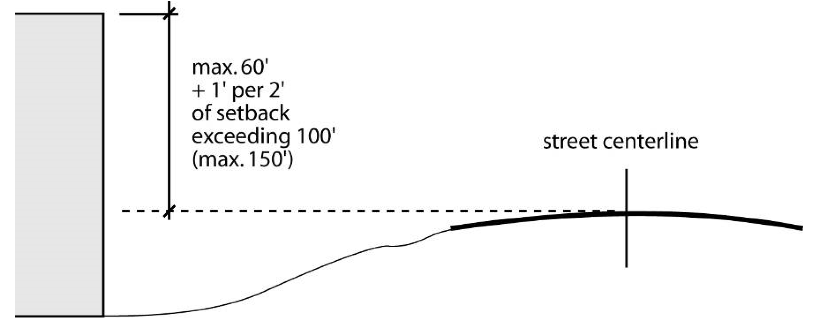
(C)
Special Highway Bufferyards.
(1)
Bufferyard Required.
(a)
A Special Highway bufferyard must be provided and maintained immediately adjacent to and along each side of the Special Highway right-of-way, including the full length of controlled access right-of-way associated with the Special Highway that extends away from the Special Highway at intersections.
(b)
Where the underlying zoning is a Residential district and the principal use, either existing or proposed, is a one-family or two-family dwelling, the minimum width of the Special Highway bufferyard is 30 feet. In all other cases, the minimum width of the Special Highway bufferyard is 50 feet.
(c)
Where public necessity requires the location of major public utility lines adjacent to a Special Highway and the easement or right-of-way for a line precludes provision of a Special Highway bufferyard immediately adjacent to the highway right-of-way, the required bufferyard must be provided adjacent to the outer edge of the utility easement or right-of-way. The public utility line easement or right-of-way must be screened in accordance with the requirements of (C)(2) below.
(2)
Bufferyard Screening and Vegetation.
(a)
Along that part of the Special Highway bufferyard closest to the Special Highway, existing vegetation must be retained or supplemented with additional planting as necessary to provide Type A Screening. Within the remainder of the bufferyard existing vegetation must be left undisturbed except as necessary to allow the construction or installation of structures permitted in the bufferyard (see (c) below). The provisions of subsections 16-10-3, 16-10-3(B), 16-10-3(C) and 16-10-3(D), applicable to bufferyards, also apply to Special Highway bufferyards.
(b)
Where public necessity requires the location of major public utility lines adjacent to a Special Highway, sufficient vegetation and/or other screening must be retained or provided within the Special Highway right-of-way (with approval from NCDOT) or the public utility line easement or right-of-way to minimize any dominating linear view of the cleared utility line easement or right-of-way seen by travelers on the Special Highway.
(c)
The following minor structures are allowed in a Special Highway bufferyard:
i.
Pedestrian or bicycle paths, including steps;
ii.
Planters, retaining walls, fences, park tables and seating, hedges, and other landscaping structures; and
iii.
Utility lines (above or below the ground), their support structures, and minor structures accessory to utility lines, provided that they generally cross rather than run along the length of the bufferyard.
(D)
Exterior Lighting. All exterior lighting must be constructed or located so that the light source is not directly visible from a vehicle traveling on the Special Highway.
3-72 - RCOD-1, Resource Conservation Overlay District.
3-72-1
Purpose; Locational Criteria.
(A)
The RCOD-1, Resource Conservation overlay district is intended to:
(1)
Protect and preserve the water quality of designated special water impoundments while allowing the orderly development of land in the watersheds of these sensitive areas;
(2)
Protect the water quality in these impoundments by requiring vegetated buffer areas around them as well as along drainageways leading to them; and
(3)
Be applied within special watersheds and such other significant physical and biological areas and habitats as the Wake County Board of Commissioners deems appropriate.
(B)
Special water impoundments provide significant wildlife or plant life habitats, possess characteristics unique to Wake County, public recreation, or offer potentials for future public recreation.
3-72-2
Allowed Uses. Principal uses are allowed in the RCOD-1 overlay district in accordance with the use regulations of the underlying base zoning district, except that location of such uses are restricted as required by the requirements of this section.
3-72-3
Other District-Specific Regulations. The standards of both the RCOD-1 overlay district and the underlying district apply. Where the standards of the overlay district and the underlying district differ, the more restrictive standards control. All limits of disturbance within watershed buffers apply to each side of the water body.
(A)
One hundred-foot-wide special water impoundment buffers must be maintained around special water impoundments. Special water impoundment buffers must be measured perpendicular to the normal pool shoreline of the special water impoundment, and must extend 100 feet from the normal pool shoreline of the special water impoundment, inside the watershed draining into that impoundment.
(B)
Fifty-foot-wide drainageway buffers must be maintained along each side of a stream, and 25-foot wide drainageway buffers must be maintained along each side of an upper watershed drainageway, up to a point where less than five acres are drained by such upper watershed drainageway. In order to determine the amount of land drained by an upper watershed drainageway or a stream, USGS or Wake County topographic maps may be used.
(C)
Fifty-foot-wide water impoundment buffers must be maintained around water impoundments located on a stream, and 25-foot-wide water impoundment buffers must be maintained around water impoundments located on an upper watershed drainageway.
(D)
Drainageway buffers, water impoundment buffers, and special water impoundment buffers must be designated on lots created after November 19, 1986. Vegetation within such buffers must remain undisturbed except as may be necessary to accommodate any of the following uses:
(1)
Boat docks, ramps, piers, or similar structures;
(2)
Greenways, pedestrian paths, path shelters and benches, and related recreational uses;
(3)
Reconstruction, rehabilitation, or restoration of structures listed on the National Register of Historic Places;
(4)
Drainage facilities or utilities;
(5)
Roads, provided they cross the buffer at a horizontal angle of at least 60 degrees;
(6)
Forestry and husbandry activities that eliminate diseased, infected or damaged timber or nuisance vegetation;
(7)
Sedimentation and erosion control measures and devices as approved by the Department of Environmental Services;
(8)
Grassed yards; and
(9)
Construction of new lakes or ponds, provided that applicable buffers are designated around such new lakes or ponds.
(E)
All buildings must be set back at least 20 feet from the edge of any drainageway buffer, special water impoundment buffer, or water impoundment buffer.
(F)
In the event of conflict with other applicable regulations, the more restrictive regulation will govern.
(G)
Some streams may require both special watershed buffers and Neuse River riparian buffers.
3-73 - RCOD-2, Resource Conservation Overlay District 2.
3-73-1
Purpose and Intent.
(A)
The RCOD-2 overlay district is intended to protect and preserve the water quality of special watersheds while allowing the orderly development of land in the watersheds of these sensitive areas. The purpose of these regulations is consistent with the Wake County Comprehensive Plan and otherwise advance the public health, safety, and general welfare.
(B)
Special watersheds provide significant wildlife, aquatic and other organisms, or plant life habitats; possess characteristics unique to Wake County. It is the intent of these regulations to protect the water quality in these watersheds by requiring vegetated buffer areas along perennial streams and stormwater runoff controls.
(C)
As is the case with any regulation or provision of this ordinance, when practical difficulties or unnecessary hardships would result from carrying out the strict letter of the regulation, the Board of Adjustment may vary or modify said regulation after making findings of fact supporting its conclusions in accordance with Sec. 19-26.
[Amended on 11/21/2022 by OA-02-22]
3-73-2
District Boundary. RCOD-2 overlays districts must be appropriately located within special watersheds and such other significant physical and biological areas and habitats, as the Wake County Board of Commissioners deems appropriate.
3-73-3
Regulation Of Uses. The uses permitted or prohibited in the RCOD-2 district will be those uses permitted or prohibited in the underlying zoning district.
3-73-4
Existing Development, Redevelopment, and Expansions.
(A)
Existing development is not subject to the requirements of this section; existing development will be considered to be any impervious surfaces created, or for which a vested right has been established, as of May 31, 2005.
(B)
Redevelopment and expansions of any existing nonresidential development will be subject to the requirements of this section; however, the impervious surface coverage of the existing development is not required to be included when applying the impervious surface coverage limits of this section.
3-73-5
Uses Exempted. Bona fide farms, including land held for forestry practices, are exempt from the provisions of this section, provided that farming constitutes the primary use of the property. Any use of farm property for non-farm purposes is subject to these regulations.
3-73-6
Development Standards. The following standards apply in RCOD-2 district. The standards of both the RCOD-2 district and the underlying district will apply. Where the standards of the Overlay District and the underlying district differ, the more restrictive standards will control on lots created after May 31, 2005.
(A)
Stormwater Runoff Control.
(1)
Peak stormwater runoff leaving any site for the one-year storm may be no greater for post development conditions than pre-development conditions. The same methodologies used to calculate stormwater runoff must be used for both pre-development and post-development conditions.
(2)
In addition to those activities exempted above, the stormwater runoff control requirements of this section will not apply to one or more of the following:
(a)
The increase in peak stormwater runoff between pre-development and post development conditions for the one-year storm is ten percent or less.
(b)
The maximum impervious surface coverage of the lot is no more than 15 percent and the remaining pervious portions of the lot are utilized to convey and control the stormwater runoff of the lot to the maximum extent practical. In determining a subdivision lot's eligibility for this exemption, the amount of impervious surface coverage in a lot will be increased by the lot's proportional share of impervious surface coverage devoted to roadways and improvements in the subdivision and will be decreased by the lot's proportional share of subdivision parcels devoted to open space, had they been created as building lots. Any lot which is exempted from the runoff control requirements by this subsection, must comply with all the requirements of this section whenever:
i.
The exempted lot is subdivided; or
ii.
The exempted lot size is reduced by recombination; or
iii.
Impervious surfaces on the exempted lot equal or exceed the maximum allowable as determined in Section 3-73-6(A)(2)(b).
(c)
Compliance with the runoff limitations in Section 3-73-6(A) would result in greater adverse downstream impact, such as local flooding, as determined by County approved engineering studies.
(d)
The County reserves the right to require stormwater runoff control measures for projects without any measures, and the County reserves the right to require additional stormwater runoff control measures for projects which are complying with this section if stormwater runoff from the site will cause adverse effects on other properties including without limitation public streets, greenway, and utility easements.
(B)
Location and Width of Special Watershed Buffers. The location and width of the special watershed buffer must be maintained as shown below:
(1)
General.
(a)
In the event of conflict with other applicable regulations, the more restrictive regulation will govern.
(b)
Some streams may require both special watershed buffers and Neuse River riparian buffers.
(2)
Perennial Streams.
(a)
A special watershed buffer with a minimum width of 100 feet must be provided along each side of a stream shown as a perennial stream from the 1999 Wake County Surface Water Survey Mapping Project—1:1,200 scale map.
(b)
The buffer width is to be measured perpendicular to the river or stream bank starting at the river or stream bank.
(c)
There is no minimum building setback from the required buffer.
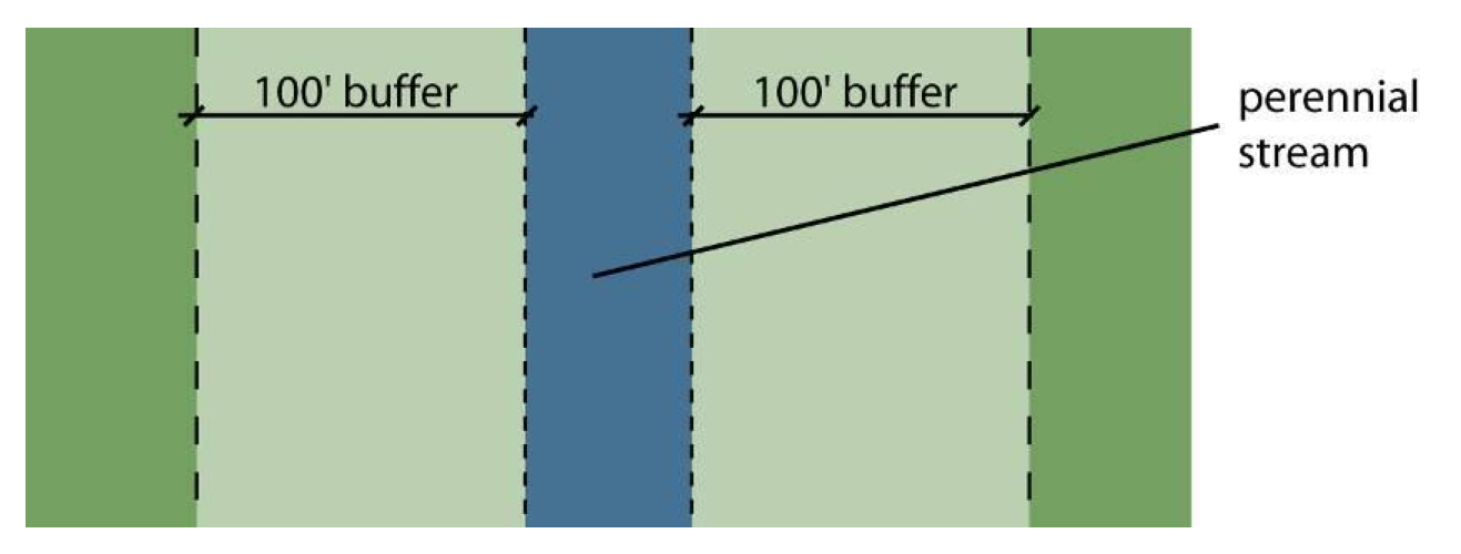
3-73-7
Activities Allowed Within Special Watershed Buffers.
(A)
General. The required 100-foot buffer along a perennial stream must consist of a vegetated area that is undisturbed except for the activities expressly allowed to occur within special watershed buffers pursuant to Section 3-73-7(B). All limits of disturbance within watershed buffers apply to each side of the water body.
(B)
Activities Allowed within Required Special Watershed Buffers. Only the activities listed below are allowed within required special watershed buffer areas:
(1)
Archeological activities, provided any vegetation removed is restored with vegetation of a comparable assimilative capacity.
(2)
Bridges, provided no reasonable alternative to their location in the buffer exists.
(3)
Dam maintenance activities.
(4)
Vegetated swales, provided:
(a)
No reasonable alternative to their location in the buffer exists; and
(b)
A stormwater management facility is installed to control nitrogen and attenuate flow before the conveyance discharges through the buffer
(5)
Drainage of a pond, provided a new vegetated special watershed buffer meeting the purpose and requirements of this Section is established along the new drainageway
(6)
Driveway crossings that access single-family dwellings, provided:
(a)
No reasonable alternative to their location in the buffer (including opportunity for shared driveways) exists;
(b)
Buffer disturbance is no more than 60 feet wide [1];
(c)
Buffer disturbance is no more than 6,000 square feet in area;
(d)
The driveway crosses the buffer at an angle as close to 90 degrees as possible (and not less than 60 degrees);
(e)
Side slopes do not exceed a 2:1 (horizontal to vertical) ratio (bridging and/or retaining walls may be used to meet this and the disturbance width standard); and
(f)
All culverts are designed and constructed for the 25-year storm event or as otherwise required by Wake County Environmental Services.
(7)
Utility lines, provided:
(a)
No reasonable alternative to their location in the buffer exists;
(b)
A line crossing the buffer is combined with other permitted buffer crossings where practicable;
(c)
Buffer disturbance is not more than 40 feet wide;
(d)
Woody vegetation is removed by hand (no land grubbing or grading);
(e)
Vegetative root systems and stumps from cut trees are retained;
(f)
No rip rap is used unless necessary to stabilize a pole or tower;
(g)
Active measures are taken after construction and during routine maintenance to ensure diffuse flow of stormwater through the buffer;
(h)
Mats are used to minimize soil disturbance (in wetlands);
(i)
Poles or towers are not installed within ten feet of the lake, pond, river, stream, or drainageway;
(j)
The area within ten feet of the lake, pond, river, stream, or drainageway is managed so that only vegetation posing a hazard or with a potential to grow tall enough to interfere with the line is removed;
(k)
Construction activities minimize removal of woody vegetation, the extent of disturbed area, and the time during which areas remain in a disturbed state;
(l)
Cables are installed by vibratory plow or trenching; and
(m)
Trenches are backfilled with the excavated material immediately following line installation.
(8)
Wells, subject to applicable local, state, and federal regulations.
(9)
Sewage disposal systems, on-site (including, but not limited to, septic tanks, pumps, and ground absorption areas), provided that this is a replacement of an existing sewage disposal system, approved by the Director of Health and Human Services.
(10)
Recreation trails (public or private), provided:
(a)
no reasonable alternative to their location in the buffers exists
(b)
A trail crossing the buffer is combined with other permitted buffer crossings where practicable;
(c)
Buffer disturbance is no more than 20 feet wide (unless otherwise approved by Wake County Environmental Services);
(d)
The trail is no more than 12 feet wide;
(e)
A trail crossing the buffer does so at an angle as close to 90 degrees as possible (and not less than 60 degrees); and
(f)
Trail running linearly within the buffer must be located in the outer 20 feet of the buffer
(g)
[Use of pervious surfacing materials is encouraged]
(11)
Railroad crossings, provided:
(a)
No reasonable alternative to their location in the buffer exists;
(b)
Buffer disturbance is not more than 60 feet wide; and
(c)
Buffer disturbance is no more than 6,000 square feet in area
(12)
Removal of fill deemed harmful to the stream's water quality, provided:
(a)
No excavation below the prior natural elevation;
(b)
Diffuse flow is maintained; and
(c)
Any vegetation removed is restored with woody native species of equivalent or better quality
(13)
Road crossings (public or private roads), provided:
(a)
No reasonable alternative to their location in the buffer exists;
(b)
Buffer disturbance does not extend beyond the required right-of-way or easement width, or in no case is more than 90 feet wide;
(c)
Buffer disturbance is no more than 9,000 square feet in area;
(d)
The road crosses the buffer at an angle as close to 90 degrees as possible (and not less than 60 degrees);
(e)
Side slopes do not exceed a 2:1 horizontal: vertical ratio (bridging and/or retaining walls may be used to meet this and the disturbance width standard); and
(f)
All culverts are designed and constructed for the 25-year storm event or as otherwise required by Wake County Environmental Services.
(14)
Scientific studies and stream gauging
(15)
Stormwater management ponds, provided
(a)
No reasonable alternative to their location in the buffer exists; and
(b)
A new vegetated buffer is established around the new pond
(16)
Stream restoration and bank stabilization for mitigation purposes only
(17)
Temporary in-stream sediment and erosion control measures for work within a stream channel
(18)
Manual vegetation management is permitted but no grubbing or excavation; manual vegetation management may include:
(a)
Emergency fire control measures, provided topography is restored;
(b)
Planting vegetation to enhance the buffer's function;
(c)
Pruning forest vegetation, provided the health and function of the vegetation is not compromised;
(d)
Removing individual trees that are in danger of causing damage to dwellings, other structures, or human life; and
(e)
Removing poison ivy; and other noxious growth
(19)
Water dependent structures (See definition, Section 21-11)
(20)
Wetland restoration
3-73-8
Design, Construction, and Maintenance of Disturbances Within Special Watershed Buffers. Any allowed disturbance that occurs as a result of the activities expressly permitted in Section 3-73-7(B) must be designed, constructed, and maintained so as to:
(A)
Minimize impervious or partially impervious surface coverage;
Commentary: The use of pervious surfacing materials and/or dual ribbon design is encouraged.
(B)
Diffuse the flow of stormwater runoff, encourage sheet flow and avoid concentrated discharge of stormwater into surface waters;
(C)
Maximize the use of Best Management Practices (BMPs) to minimize adverse water quality impacts; and comply with all applicable standards and conditions of Section 3-73-7(B).
[OA 05/02 May 16, 2005; Amended on 11/18/2024 by OA-01-24]
3-74 - WSO, Water Supply Watershed Overlay District.
3-74-1
Purpose. The WSO, Water Supply Watershed Overlay district is intended to ensure that the quality of public water supplies is protected while allowing limited orderly development. The regulations of the WSO overlay district protect water quality by requiring vegetated watershed buffers around surface water bodies and streams and by limiting the area of impervious coverage. The subdistricts and their accompanying development standards are consistent with the classifications used by North Carolina Department of Environment and Natural Resources and recognize the varying function and sensitivity of different watershed areas.
3-74-2
Subdistricts Established. The WSO overlay district includes the following subdistricts:
(A)
WSO-2NC, Water Supply Watershed II (Non-Critical Area). The WSO-2NC overlay district is intended to be applied to the area outside of the designated critical area of all WS-II watersheds outside of the watershed's critical area, as classified by the North Carolina Department of Environment and Natural Resources.
(B)
WSO-3NC, Water Supply Watershed III (Non-Critical Area). The WSO-3NC overlay district is intended to be applied to the area outside of the designated critical area of all WS-III watersheds, as classified by the North Carolina Department of Environment and Natural Resources.
(C)
WSO-3CA, Water Supply Watershed III (Critical Area). The WSO-3CA overlay district is intended to be applied to the designated critical area of all WS-III watersheds, as classified by the North Carolina Department of Environment and Natural Resources.
(D)
WSO-4P, Water Supply Watershed IV (Protected Area). The WSO-4P overlay district is intended to be applied to the designated protected area of all WS-IV watersheds, as classified by the North Carolina Department of Environment and Natural Resources. The overlay contains two subdistricts: WSO-4P-1 and WSO-4P-2.
3-74-3
Applicability.
(A)
WSO-2NC Designated Area. Land in a water supply watershed classified WS-II (e.g., the Little River watershed) that is outside of the watershed's critical area and that:
(1)
Is already located in an underlying district that does not apply appropriate watershed protection standards; or
(2)
Is located within a Municipal Transition Area/Water Supply Watershed and is being rezoned, in accordance with an adopted joint land use plan, to an underlying district that does not apply appropriate watershed protection standards.
(B)
WSO-3NC, Designated Area. Land in a water supply watershed classified WS-III (e.g., the Swift Creek watershed) that is outside of the watershed's critical area and that:
(1)
Is already located in an underlying district that does not apply appropriate watershed protection standards; or
(2)
Is located within a Municipal Transition Area/Water Supply Watershed and is being rezoned, in accordance with an adopted joint land use plan, to an underlying district that does not apply appropriate watershed protection standards.
(C)
WSO-3CA, Designated Area. Land in the critical area of a water supply watershed classified WS-III (e.g., the Swift Creek watershed) that:
(1)
Is already located in an underlying district that does not apply appropriate watershed protection standards; or
(2)
Is located within a Municipal Transition Area/Water Supply Watershed and is being rezoned, in accordance with an adopted joint land use plan, to an underlying district that does not apply appropriate watershed protection standards.
(D)
WSO-4P, Designated Area.
(1)
WSO-4P-1. The WSO-4P-1 subdistrict includes land in the protected area of a water supply watershed classified WS-IV—other than the Falls Lake watershed (e.g., the Jordan Lake, Cape Fear (Lillington), Cape Fear (Sanford) and Upper Neuse River/Richland Creek watersheds)—that:
(a)
Is located in an underlying district that does not apply appropriate watershed protection standards; or
(b)
Is located within a Municipal Transition Area/Water Supply Watershed and is being rezoned, in accordance with an adopted joint land use plan, to an underlying district that does not apply appropriate watershed protection standards.
(2)
WSO-4P-2. The WSO-4P-2 subdistrict includes land in the protected area of a water supply watershed classified WS-IV—other than the Falls Lake watershed (e.g., the Jordan Lake, Cape Fear (Lillington), Cape Fear (Sanford) and Upper Neuse River/Richland Creek watersheds)—that:
(a)
Has been, or is committed to being, developed with basin-wide or other large-area stormwater management systems with lakes and detention facilities that provide protection of water quality beyond that provided by limiting the impervious surface coverage of individual developments; and
(b)
Makes up no more than ten percent of the total land area of that portion of the watershed outside of its critical area and within the county's zoning jurisdiction as of July 1, 1995.
[Amended on 11/21/2022 by OA-02-22]
3-74-4
Exemptions. Existing development is not subject to the requirements of Sec. 3-74; existing development must be considered to be any impervious surfaces created, or for which a vested right has been established, as of December 31, 1993. Redevelopment and expansions of any existing development are subject to the requirements of this section; however, the impervious surface coverage of the existing development is not required to be included when applying the impervious surface coverage limits of this section. The land area to which this section's impervious surface coverage limits are applied is the total area of a parcel minus the area of impervious surfaces existing or vested as of December 31, 1993.
3-74-5
General Standards. All development within WSO overlay districts must, to the maximum extent practicable, minimize impervious or partially pervious surface coverage, direct stormwater away from surface waters, incorporate Best Management Practices (BMPs) to minimize water quality impacts, and transport stormwater runoff from the development by vegetated conveyances.
3-74-6
Allowed Uses. Principal uses are allowed in all WSO overlay districts in accordance with the use regulations of the underlying base zoning district.
3-74-7
Lot and Building Standards.
(A)
General. The use and development of land or structures within all WSO overlay districts must comply with the use and development regulations applicable to the underlying zoning district, except that the standards of this subsection apply whenever they are more restrictive than those of the underlying zoning district.
(B)
WSO-2NC, WSO-3CA and WSO-3NC Districts. Development within WSO-2NC, WSO-3CA and WSO-3NC overlay districts must comply with the following standards whenever they are more restrictive than those of the underlying zoning district.
[1] In WSO-2NC and WSO-3CA districts, residential lots of at least 40,000 square feet
in area and residential lots in an open space subdivision or existing Cluster and
Consolidated Open Space Developments with an overall lot density no more than one
lot per acre are not subject to impervious surface coverage limits except as required
by the underlying zoning. For all other residential lots and for nonresidential developments
in those districts, impervious surface coverage may not exceed 12 percent of the total
area of the site, as designated on the site plan.
[2] ;hg;In WSO-3NC districts, residential lots of at least 20,000 square feet in area
and residential lots in an open space subdivision or existing Cluster and Consolidated
Open Space Developments with an overall lot density of no more than two lots per acre
are not subject to impervious surface coverage limits except as required by the underlying
zoning. For all other residential lots and for nonresidential developments in those
districts, impervious surface coverage may not exceed 24 percent of the total area
of the site, as designated on the site plan.
(C)
WSO-4P Districts. Development within WSO-4P districts must comply with the following standards whenever they are more restrictive than those of the underlying zoning district.
(1)
With Curb and Gutter. In a development served by a curb and gutter system, residential lots of at least 20,000 square feet in area and residential lots in an open space development or existing cluster and consolidated open space developments with an overall lot density no more than two lots per acre, are not subject to impervious surface coverage limits except as required by the underlying zoning. For all other residential lots and for nonresidential developments, the following standards apply:
(a)
WSO-4P1. In the WSO-4P1 district, impervious surface coverage may not exceed 24 percent of the total area of the site, as designated on the site plan.
(b)
WSO-4P2. In the WSO-4P2 district, impervious surface coverage may not exceed 30 percent of the total area of the site, as designated on the site plan.
Commentary: Curb and gutter are limited in water supply watersheds. See Sec. 8-32-18.
(2)
Without Curb and Gutter. In a development not served by a curb and gutter system, residential lots of at least 15,000 square feet in area and residential lots in an open space development or existing cluster and consolidated open space developments with an overall lot density no more than two lots per acre, are not subject to impervious surface coverage limits except as required by the underlying zoning. For all other residential lots and for nonresidential developments, impervious surface coverage may not exceed 30 percent of the total area of the site, as designated on the site plan.
(3)
Engineered Stormwater Control Structures. Engineered stormwater control structures must meet design guidelines of the State Division of Water Quality, or its successor agency. Responsibility for maintenance of all permanent infiltration, retention, and detention control measures and facilities, after site development is completed, rests with the owner of the use. When designed in accord with the guidelines of the State Division of Water Quality, or its successor agency, lakes and ponds used singularly or in a system for stormwater runoff control may be included as a pervious surface for the purpose of calculating the impervious surface coverage of a site.
[Amended on 11/21/2022 by OA-02-22]
3-74-8
Other District-Specific Regulations.
(A)
Watershed Buffers. Any development in water supply watershed buffer areas is subject to the requirements of Article 11, Part 2 (Water Supply Watershed Buffers)
(B)
Limitations on Use and Storage of Hazardous Materials in Nonresidential Developments. In designated Water Supply Watershed Overlay districts, the use and storage of hazardous materials is permitted in accord with local, state, and federal legislation regulating the use and storage of hazardous materials.
(C)
Requirements for Forestry Activities. Silvicultural activities are subject to the provisions of the Forest Practices Guidelines Related to Water Quality (15 NCAC 1I .0101-.0209), implemented by the State Division of Forest Resources.
(D)
Prohibited Land Applications. Land application of sludge residuals or petroleum-contaminated soils is prohibited.
(E)
Gasoline Sales Prohibited. The sale of gasoline is prohibited.
[Amended on 7/21/2008 by OA 03-08]
3-75 - Airport Overlay District.
3-75-1
Purpose.
(A)
The Airport Overlay District (AO) is established as an overlay district of all general zoning districts located within Wake County's jurisdiction that are in the general vicinity of the Franklin County Airport. The purpose of the AO district is to protect the airport environs from encroachment of incompatible land uses that would present hazards to users of the airport or to persons residing or working in the airport vicinity. The supplemental regulations imposed in the AO district are designed to place a height restrictions of 1,050 feet on buildings and structures, as well as some limitations on uses and lighting within this area.
(B)
It is the intent of this section:
(1)
To prevent creation of conditions hazardous to aircraft operation,
(2)
To prevent conflict with land development which may result in a loss of life and property, and
(3)
To encourage development this is compatible with airport use characteristics within the intent and purpose of zoning.
(C)
To this end, the AO designation, when applied to a base zoning district classification, is intended to coordinate the purpose and intent of this section with other regulations duly established by the Wake County Unified Development Ordinance whose primary intent is to further the purposes set out above.
3-75-2
Definitions. For purposes and intent of this section, the following definitions and terms are to be considered:
Airport within this section, shall refer to the Franklin County Airport.
Hazard to Navigation means an obstruction determined to have a substantial adverse effect on the safe and efficient use of the navigable airspace.
Height, for the purpose of determining the height limits in the AO district, the datum shall be mean sea level elevation unless otherwise specified.
MSL means Mean Sea Level.
Obstruction means any structure or other object, including a mobile object, which exceeds a height of 1,050 feet within the portion of Wake County where this Airport Overlay district applies.
Runway means a defined area at an airport prepared for landing and takeoff of aircraft along its length.
Structure means an object, including a mobile object, constructed or installed by man, including but not limited to buildings, towers, cranes, smokestacks, earth formation, and overhead transmission lines.
3-75-3
Height Limitations. Except as otherwise provided in this section, no structure shall be erected, altered or maintained in the AO district created by this section at an elevation in excess of 1,050 feet above mean sea level.
3-75-4
Use Restrictions.
(A)
Notwithstanding any other provisions of this section, no use may be made of land or water within the AO district in such a manner as to:
(1)
Create electrical interference with navigational signals or radio communications between the airport and aircraft,
(2)
Make it difficult for pilots to distinguish between airport lights and others,
(3)
Result in glare in the eyes of pilots using the airport,
(4)
Impair visibility in the vicinity of the airport,
(5)
Create bird strike hazards, or
(6)
Otherwise in any way endanger or interfere with the landing, takeoff, or maneuvering of aircraft intending to use the airport.
(B)
Amateur radio operators must comply with Part 97 of the Federal Communications Commission (FCC) regulations.
(C)
All outdoor lighting must be shielded in such a manner that no direct glare from the light source can be seen from above. This restriction does not apply to warning lights such as those installed on towers, tall buildings, etc., to mark obstructions to aircraft.
3-75-5
Nonconforming Uses.
(A)
Regulations Not Retroactive. The regulations prescribed by this section shall not be construed to require the removal, lowering or alteration of any structure not conforming to the AO district regulations as of the effective date of this section, or to otherwise interfere with the continuance of a nonconforming use. Nothing contained herein shall require any change in the construction, alteration or intended use of any structure, the construction or alteration of which was begun prior to the effective date of this section.
(B)
Markings and Lighting. Notwithstanding the preceding provision of this section, the owner of any existing nonconforming structure may be required to permit the installation, operation and maintenance thereon of such markers and lights as shall be deemed necessary by the Franklin County Airport Commission to indicate to the operators of aircraft in the vicinity of the airport the presence of such airport obstruction. Such markers and lights shall be installed, operated and maintained at the expense of Franklin County Airport Commission.
(C)
Existing Uses. No permit shall be granted that would allow the establishment or creation of an obstruction, or permit a nonconforming use or structure to become a greater hazard to air navigation than it was on the effective date of this section.
(D)
Nonconforming Uses Abandoned or Destroyed. Whenever the Planning Director determines that a nonconforming structure has been abandoned, or more than 80 percent destroyed, physically deteriorated or decayed, no permit shall be granted that would allow such structure to be repaired, replaced or to continue to exist at a height that would exceed the AO height limit of 1,050 feet above mean sea level.
3-75-6
Issuance of Permits. The Planning Director shall not issue any permit for development within the AO district until it has been determined that the proposal is in compliance with the regulations contained in this section.
Except as specifically provided herein, no change shall be made in the use of land, nor shall any structure be erected or otherwise established unless an appropriate permit, which includes a confirmation of compliance with the AO regulations, has been applied for and granted. Each application for a permit shall indicate the purpose for which the permit is desired, with sufficient information to determine whether the resulting use or structure would conform to the regulations herein prescribed. No permit for a use inconsistent with the provisions of this section shall be granted unless a variance has been approved in accordance with subsection 3-75-7 below.
Any permit or variance granted may be conditioned to require the owner of the structure, or proposed structure, to install, operate or maintain, at the owner's expense, such markings and lights as may be deemed necessary to ensure aircraft safety as determined by the FAA, the Franklin County Airport manager, and/or the Franklin County Airport Commission. If deemed proper by the Board of Adjustment, this condition may require the owner to permit the Franklin County Airport Commission, at its own expense, to install, operate and maintain the necessary markings and lights.
3-75-7
Variances. Any person desiring to erect a structure, or increase the height of an existing structure, or use property not in compliance with the regulations prescribed in this section may apply to the Board of Adjustment for a variance in accordance with the provisions of Section 19-26, Variances.
The application for a variance shall be accompanied by a determination from the Federal Aviation Administration (FAA) as to the effect of the proposal on the operation of air navigation facilities or the safe and efficient use of navigable airspace. Such variances shall be allowed where the Board of Adjustment reaches positive findings of facts as outlined in Section 19-26-7 and a determination is made that the variance will not create a hazard to air navigation.
Additionally, no application for a variance to the requirements of this section may be considered by the Board of Adjustment unless a copy of this application has been furnished to the Franklin County Airport manager and/or the Franklin County Airport Commission for advice as to the aeronautical effects of the variance. If the airport manager and/or the airport commission do not respond to the application within 30 days after receipt, the Board of Adjustment may act on its own to grant or deny the variance request.
[Section 3-75 added 5/21/2007 by OA 01-07]