Whittier City Zoning Code
CHAPTER 18
14 - H-R HILLSIDE RESIDENTIAL ZONE
18.14.010 - Purpose.
The purpose of the city council in enacting the provisions of this chapter is to provide for a safe method of limited development of hillside areas within the city, as described in this chapter, in a manner which will preserve, to the greatest extent possible, existing environment of the area, including natural terrain features consistent with the general plan. The primary purpose of this chapter is to preserve for future generations the unique heritage of open space, and a natural environment in hillside areas within the city and its sphere of influence. Further, in that regard, should any conflict arise in the application of various provisions of the city's zoning regulations for any hillside area or areas, the planning commission and city council shall give preference to the need to vigorously protect the natural environment of the hillside against change.
(Prior code § 9165)
18.14.020 - Applicability.
The provisions of this chapter shall apply to those properties designated in this chapter as being included within a "hillside area." For the purposes of this chapter, the phrase "hillside area" means and refers to all real property as is shown on those certain maps attached to the ordinance codified in this section, incorporated herein by reference and entitled, "Hillside and Biological Sensitivity Areas — city of Whittier Zoning Regulations, Division G, Part 4, Chapter 1, Article IX, Whittier Municipal Code, October 23, 1979." The zoning map shall be amended to show the properties which have been classified in the hillside area by adding the zoning designation, on each such property, of "HR."
(Prior code § 9166)
18.14.030 - Permitted uses.
No person shall use, nor shall any property owner permit, the use of any lot classified in zone H-R for any use other than the following:
A.
Principal Uses.
1.
One single-family dwelling;
2.
Recreational facilities for the exclusive use of the residents of a development, designated as such on an approved plan;
3.
Those uses allowed in zone R-E for which a conditional use permit is required, pursuant to Section 18.52.030; and
4.
Residential care facilities, as defined in Section 18.06.369 of this code, serving six or fewer persons.
B.
Accessory Uses. Those accessory uses expressly permitted pursuant to the provisions of Chapter 18.10 of this code.
C.
Accessory dwelling units and junior accessory dwelling units in compliance with the requirements of Section 18.10.020(I), Accessory Dwelling Units.
(Ord. 2897 § 10, 2008)
(Ord. No. 3116, § 12, 5-26-20)
18.14.040 - Development plan—Required.
No building permit shall be issued for any building or structure proposed to be located on any real property classified in the H-R zone unless and until a hillside development plan (in this chapter, "plan"), therefor is first approved in the time and manner set forth in this chapter.
(Prior code § 9168)
18.14.050 - Development plan—Compliance.
Where a plan is approved, no building or structure shall be constructed, erected, located or maintained upon any lot to which such plan applies, unless such building or structure is in compliance with the approved plan. No building permit shall be issued for any building or structure to be located upon any lot as to which such plan applies unless and until the director finds the same to be consistent and compatible with the applicable approved plan.
(Prior code § 9169)
18.14.060 - Development plan—Application.
Where a plan is required pursuant to this chapter, an application for approval of such a plan shall contain the following:
A.
A map or maps showing the following:
1.
All known public and private easements adjacent to or on the property which is the subject of the plan; and
2.
Location of all dumps, fills, sumps, oil, gas and water wells; and
3.
Proposed size of each lot, including all lot lines as proposed; and
4.
Approximate size and location of proposed building pads and driveways, including approximate grades of driveways; and
5.
Cut-and-fill slopes, banks and terraces, and topographic detail to include whole ridges and whole canyons, even if on adjacent properties, including approximate finished elevations of building pads, driveways, property lines and slopes; and
6.
All existing and proposed drainage systems; and
7.
Existing landmarks and natural terrain features, and those existing landmarks and natural terrain features which are proposed to be retained; and
8.
A schematic landscaping plan, including location, type and size of street trees, terraces, parking areas and public areas; and
9.
All existing and proposed roadways, public or private; and
10.
All proposed retaining walls and protective fences, including location, height and proposed material; and
11.
Sight distances (horizontal and vertical) at all streets and driveways; and
12.
Location of known fault lines; and
13.
Topographic maps, at a scale of one inch equals one hundred feet or less, shall include contour intervals of not more than five feet, and any trees in excess of three inches in diameter, measured three feet above natural grade. The maps shall show topography before and after proposed grading; the maps shall include, when so required by the director, natural contours in existence before any grading was accomplished. The maps required under this chapter shall be prepared and certified to by a person properly licensed to do land surveying. The maps required by this section, after review and approval by the city, shall be used to determine the density permitted pursuant to subsection C of Section 18.14.080. Such maps shall also be utilized for the purpose of applying the provisions of subsection D of Section 18.14.080;
B.
A statement containing the following data:
1.
The type of house for which pads are designed (split-level, slab or cantilever); and
2.
Dwelling-unit density proposed; and
3.
Proposed covenants, conditions and restrictions; and
4.
Available utilities; and
5.
Architectural style of houses; and
6.
With the approval of the director, compliance with subdivisions 1 and 2 of this subsection may be deferred until applications for a building permit are made;
C.
A soils and geologic report prepared by a registered soils engineer and/or registered geologist in the state including any known groundwater conditions (dump site, oil-well site, natural ground, etc.;
D.
Scale models, showing existing and proposed contours, together with representative buildings.
(Prior code § 9169.1)
18.14.070 - Development standards—Applicability.
The provisions of this title shall apply to all uses, buildings and structures located or constructed in any H-R zone, except as expressly provided to the contrary in this chapter.
(Prior code § 9169.2)
18.14.080 - Development standards—Compliance.
All uses of property within the H-R zone shall comply with the following development standards:
A.
Compliance with Plan. Each use, building and/or structure shall be constructed, located and thereafter maintained in compliance with the approved plan; and
B.
Compliance with Regulations. Each use, building and/or structure shall be constructed, located and thereafter maintained in compliance with the regulations set forth in this title, including but not limited to Chapter 18.10; and
C.
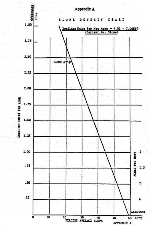
Density Regulations. Property classified in zone H-R may have and maintain not to exceed the number of dwelling units permitted by the following formula. However, under no circumstances may the yield per net acre exceed three units:
Yield per Net Acre (see also Appendix A of this chapter, "Slope Density Chart").
Y = 4.03 − 0.06857 × S)
"Y" is the maximum number of residential dwelling units per net acre.
"S" is the average slope of the parcel in percent as established in Section 18.14.080D7.
"4.03" is where Line A intersects the ordinate line in Appendix A.
".06857" is the slope of Line A in Appendix A.
The above formula is based on the natural average percentage of slope for the various parcels as shown on the map referenced in Section 18.14.020.
D.
Grading. No person shall permit or allow any grading, as that phrase is defined in subdivision 1 of this subsection, upon any property classified in zone H-R, except in compliance with the following:
1.
For the purposes of this chapter, "grading" means any excavating or filling or combination thereof involving the removal, movement or relocation of dirt by hydraulic or mechanical means, except for that necessary for landscaping or maintenance of yards, unless such work changes the finished contours in a manner which would cause surface water to flow onto adjacent public or private properties. A grading plan therefor has been lawfully issued pursuant to Section 18.14.150 of this chapter; and
2.
All graded slopes are contoured and blended to harmonize with natural slopes; and
3.
Each building and structure is designed to fit, as closely as possible, the natural landform, through the use of split-level house designs and other similar techniques; and
4.
The maximum vertical height of cuts or fills, exposed or retained by walls, from toe to top, shall not exceed twenty feet, except this provision shall not apply to slopes created by grading for streets, as specifically approved on a plan. However, the intent of minimizing manmade slopes shall be the guiding factor in creating streets; and
5.
The maximum steepness of cuts and fills shall not exceed 2:1; and
6.
Building sites shall not be pregraded until specific house-site plans and elevations have been approved for each individual site; and
7.
Average Slope.
a.
If the "average slope" of a property, as defined in this chapter, is between one percent and fifty percent, the following schedule shall be utilized to determine the maximum percentages of the ground surfaces of the site that may be graded as approved as part of the plan. All sloping areas of the site which are fifty percent or greater shall not be graded except to correct previous grading, landslide or unstable soil areas, and therefore shall not be included for the purpose of applying the following slope averaging formula to establish which areas may be graded. In no event may the area of a slope which was fifty percent or greater, on the date the application was submitted, be built upon even if these areas have had corrective grading which results in slopes less than fifty percent, except that the city council may allow grading for streets in such an area, but only if it finds that such streets are necessary for primary access to a developable area.
Slope Average Formula
b.
The "average slope" of a parcel of land or any portion thereof shall be computed by applying the following formula to the natural slope of the land, before any grading is commenced. For the purpose of establishing density yield for any given parcel as referenced in subsection C of this section, the formula comprising Appendix A, entitled Slope Density Chart, shall be applied to the entire parcel being considered for development. For the purpose of determining which areas of the site may be graded, the following formula shall be applied only to those portions of the site with less than a fifty-percent slope.
S = 0.00229 IL
A
c.
"Natural slope" means areas which have not been previously significantly graded, or where there is no landslide activity.
E.
Potential Hazard Areas. No building or structure shall be located on property which is within any area described on the map referred to in Section 18.14.020 as a "potential hazard area," unless a competent geologic report unequivocally shows that the proposed placement of the specific buildings and/or structures can be safely accomplished.
F.
Natural Features. Each applicant submitting the plan shall specifically describe thereon all of the property proposed for development which is included within a "major ridge line," or within a "major flora and fauna area." The delineation shall be based upon the designation of such "major ridge lines" and/or "major flora and fauna areas," as referred to in the map referenced in Section 18.14.020. No building or structure shall be located, constructed or maintained on any property designated as the site of a "major ridge line," or a "major flora and fauna area" on an approved plan, except that streets, ways and emergency vehicular access routes may, if necessary for primary access to developable areas, be located thereon so long as the city council finds that the location of any such facilities will not cause biological damage to those areas, or any other area necessary to the continued survival of plant and animal population in those areas.
1.
Those areas shown as "moderate sensitivity" on the map referred to in Section 18.14.020, labeled as "biological sensitivity," shall be given special consideration so as to retain these areas to the maximum extent possible. Consideration shall be given and findings made as to the relationship between all biological and wildlife corridor areas, major ridge lines, and the proposed development during approval of a plan.
2.
Since it is required that even ridge lines not specified as major ridge lines in this subsection may be aesthetically important and warrant protection, specific development guidelines for all such ridge lines shall be formulated at the hillside-plan level of development based upon the specific ridge line and the type and extent of individual development.
3.
With respect to hillside areas proposed for development in the future, and for which major ridge lines and major flora and fauna areas have not yet been designated, the planning commission and city council shall utilize criteria for making such designations which afford environmental protection to at least the same extent as that now provided in areas for which such designations are made in this subsection.
G.
Fire Protection. Because all of the properties classified within the H-R zone are in areas designated as high fire-risk areas, the following fire protection measures shall be observed and maintained for each dwelling unit:
1.
Each habitable structure shall be provided with fire-retardant roof covering consistent with the provisions of the city's building regulations; and
2.
Around each habitable structure, there shall be an area cleared of native brush to a minimum twenty-foot radius from the structure. Such area shall be replanted with perennial grasses or other fire-resistant plants or ground cover and continually maintained, and shall be provided with automatic sprinkler systems; and
3.
As determined by the fire chief, all brush shall be removed and cleared within twenty feet of each side of every roadway. This includes all flammable vegetation or other combustible growth. This provision shall not apply, however, to single specimen trees, ornamental shrubbery, and cultivated ground cover, such as grass, ivy, succulents, or other similar plants used as ground cover, provided they do not form a means of readily transmitting fire.
H.
Erosion Control. To prevent damage by reason of erosion of land, the following standards shall be observed in all H-R zones:
1.
All manufactured slopes shall be planted or otherwise protected from the effects of storm- runoff erosion, in a manner approved by the director of parks, within thirty days of the completion of the grading. Planting shall be designed to blend the slope in with the surrounding terrain and development; and
2.
Permanent irrigation systems shall be provided to insure the proper maintenance of the planted areas; and
3.
Each plan shall provide a suitable method for insuring compliance with landscaping and irrigation plans, which shall be approved as a part of such plan for all manufactured slopes and recreation areas.
I.
Off-Street Parking. Each residential unit located within the H-R zone shall be provided, permanently, with two off-street parking spaces, constructed and maintained in accordance with the parking development standards set forth in Chapter 18.48. In addition, there shall be provided one additional off-street parking space per dwelling unit located within a minimum of one hundred fifty feet from the unit served thereby.
(Prior code § 9169.3)
18.14.090 - Application—Fees.
Applications for plans shall be filed with the director, and shall consist of the following:
A.
The material required pursuant to Section 18.14.060; and
B.
Proof of ownership of property, or the written authorization from the owner permitting such filing; and
C.
Such other matter as the applicant or director may deem appropriate and material to the proposal. A filing and processing fee shall be paid at the time of the filing of the application, in an amount as set by resolution of the council.
(Prior code § 9169.4)
18.14.100 - Application—Processing.
Applications, when filed with the director, shall be submitted to the engineering, police, water, fire and building departments, and any other affected city, county or state departments for comments and recommendations. All such staff reports, including the planning department report, shall be submitted to the commission and city council for their consideration.
(Prior code § 9169.5)
18.14.110 - Application—Hearing—Approval or denial.
A.
At least ten days in advance of the time set for consideration by the commission, the director shall give written notice of the time and place of such hearing to the applicant, and to all persons owning property within three hundred feet of the exterior boundaries of the property involved in the proposed plan. If the commission finds that the plan as submitted:
1.
Is in compliance with the provisions of this chapter; and
2.
Is consistent with the subdivision and zoning regulations and the general plan; and
3.
Is compatible with present and future development of the property within the immediate vicinity; it shall recommend to the city council approval of the plan. The commission may also recommend conditions to be imposed upon such approval, if it deems the same appropriate. If the commission finds, as a result of its consideration of the plan, that the same does not comply with subdivisions A1, A2 or A3 of this section, it shall deny the plan.
B.
In cases of denial, the commission's action shall be final and conclusive, unless the applicant appeals the same to the city council by filing a written letter of appeal with the city clerk, together with a filing and processing fee in an amount set by council resolution, appealing such decision to the city council. Such an appeal shall be filed in the time and manner provided in Section 18.14.120.
(Prior code § 9169.6; Ord. No. 3112, § 4, 2-25-20)
18.14.120 - Appeal procedures—Conditions.
A.
Upon the receipt by the city clerk of an appeal in the case of a denial, or a copy of the commission's resolution recommending approval of a plan, the city clerk shall set the same for consideration by the council at its next most convenient meeting. The city clerk shall give notice in accordance with Section 18.14.110 of the time and place set for hearing thereof by the council. At such time and place the council shall consider the commission's files and all applicable staff reports, and any relevant evidence offered by any person, and determine whether the commission's action should be approved, modified or disapproved. The action of the council shall be based upon Section 18.14.110.
B.
The council may, in the case of approval of a plan, condition the same in such manner as it deems necessary to insure compliance with the purpose and intent of Chapters 18.10 through 18.22.
(Prior code § 9169.7; Ord. No. 3112, § 4, 2-25-20)
18.14.130 - Hearings—Participation by interested persons.
Hearings on plans before the commission and council shall be conducted so that all interested persons are given a reasonable opportunity to be heard in connection therewith.
(Prior code § 9169.8)
18.14.140 - Approved plan—Validity period.
A.
Duration. A plan approved pursuant to the provisions of Chapters 18.10 through 18.22 shall be valid and in effect for a period of eighteen months after approval thereof of the council. Within said period of time, the proposed development shall be commenced in accordance with said period of time.
B.
Extension by Director. The director, for good cause, may extend the period of time pursuant to this section, for a reasonable time not to exceed an additional eighteen-month period.
(Prior code § 9169.9(1))
18.14.150 - Lot, yard and open-space requirements.
A.
Lot and Yard Areas. Each approved plan, as to each lot included therein, shall:
1.
Establish a specific lot area; and
2.
Establish a specific building site; and
3.
Establish a specific building height for each building and structure.
B.
Approved Plans. Each approved plan, as to each lot included therein, may establish such required side, front and/or rear yard areas as may be reasonably required.
C.
Open Space Ownership and Maintenance. The use and maintenance of those areas covered by a plan which are to remain as undeveloped open spaces, or which are to be used for recreational purposes, shall be governed by appropriate provisions of covenants, conditions and restrictions approved by the city.
(Prior code § 9169(2)(3))
18.14.160 - Phased developments.
As a part of plan approval, the applicant may request that the property be planned and/or developed in increments of not less than one hundred acres. If the council finds that the public interest so requires, it may approve such phased planning and/or development, provided that the plan shall show, as to the entire ownership, a conceptual urban design plan showing proposed major arterial and secondary streets, storm drains, sewer trunklines and such other features as may be required by the director.
(Prior code § 9169.9(4))
18.14.170 - Repeal and amendment conditions.
There shall be no modification of, amendment to, or repeal of any provision or provisions contained in this chapter, except by a vote of the people of the city.
(Prior code § 9169.10)