
Beaufort City Zoning Code
8
ENVIRONMENTAL AND RESOURCE PROTECTION
8.1.1 - PURPOSE AND APPLICABILITY
A.
Purpose: To protect and maintain the city's community character and natural resources, this section establishes standards to protect natural systems, wildlife habitat, species diversity, and water quality.
B.
Applicability: These resource protection standards apply to all development in the city, unless expressly stated otherwise in this article.
8.1.2 - REVIEW FOR COMPLIANCE
Review for compliance with the standards of this article shall occur during:
A.
Special Exception (Section 9.13);
B.
Development Design Review (Section 9.8);
C.
Certificate of Appropriateness (Section 9.10); or
D.
Subdivision Review (Section 9.9), whichever occurs first.
8.2.1 - PURPOSE
The purpose of a Critical Area Buffer is to preserve or restore the native landscape along the marsh edge. This serves to mitigate the impact of tropical storms and hurricanes, provide a natural filtration system for runoff from adjoining development, minimize erosion and help stabilize the stream bank, protect sensitive visual and ecological resources and preserve or restore the native condition of the shoreline, and mitigate the impact of tropical storms and hurricanes.
8.2.2 - APPLICABILITY AND SIZE
A Critical Area Buffer shall be established on all property located adjacent to a Critical Line. The buffer shall be measured inward from the critical line, as defined and established by South Carolina Office of Coastal and Resource Management (OCRM), in the following increments:
A.
Transect-based districts: 30 feet minimum.
B.
Conventional districts: 50 feet minimum.
8.2.3 - DEVELOPMENT AND REMOVAL OF VEGETATION PROHIBITED
The entire buffer shall be undisturbed. Indigenous vegetation removal in the tidal area buffer is limited to that necessary to provide for a structure/activity permitted by this subsection and to provide for reasonable sight lines, with the following exceptions:
A.
Paths, steps, decks, open-air structures (up to 80 square feet), yard sculpture and furniture, docks, playground equipment, paths and streets and sidewalks accessible to the public, erosion control devices (not stormwater ponds), and any other elements linked to the critical area that are permitted by OCRM are permitted in the Critical Area Buffer.
B.
Lots in a Transect-based zoning district, with bulkheads existing at the time of adoption of the ordinance from which this chapter is derived, are exempt from the provisions of this section.
8.3.1 - PURPOSE
The purpose of these standards is to control the adverse effects of post-development stormwater runoff, and non-point and point source pollution associated with new development and redevelopment by fulfilling the following objectives:
A.
Calibrate these controls based on the context of the site to ensure that walkable, urban patterns of development are favored as the primary Best Management Practices (BMPs).
B.
Design BMPs to be shared between multiple parcels and considered at a block or regional level where possible.
C.
Minimize increases in stormwater runoff from new development or redevelopment to the maximum extent practical for the applicable design storms in order to reduce flooding, siltation, and erosion, and to maintain the integrity of stream channels, marshes and aquatic habitats.
D.
Minimize increases in non-point and point source pollution caused by stormwater runoff from development that would otherwise degrade local water quality.
E.
Minimize the total volume of surface water runoff that flows from any specific site during and following development in order to replicate pre development hydrology to the maximum extent practicable through the use of structural and nonstructural stormwater management BMPs.
F.
Establish minimum post-development stormwater management standards and design criteria for the regulation and control of stormwater runoff quantity and quality so as to meet local, state and federal water quality standards in affected watershed areas.
8.3.2 - APPLICABILITY
A.
Table of Applicability:
B.
Exemptions: The standards established in this section shall apply to all new development within the city, except for the following:
1.
Any maintenance, alteration, or improvement to an existing drainage structure that does not create adverse environmental or water quality impacts, does not impact adjacent and/or downstream properties, and does not increase the rate, or volume of stormwater runoff discharge.
2.
Development of 3 or fewer residential dwelling units, where adequate drainage exists, and that does not involve a main drainage canal. When community-wide solutions are present, on-lot retention is not required.
3.
Site work, infill development, or redevelopment on existing sites less than four acres, where impervious area is increased by less than 2% and there is no known history of water quality or quantity issues.
4.
Any site work that does not increase runoff, eliminate detention/retention facilities and/or stormwater storage, increase or alter stormwater volume, flow rates, direction or discharge location(s), or alter the natural topography.
5.
Agricultural and Silviculture activity.
6.
Work by agencies or property owners required to mitigate emergency flooding conditions — if possible, emergency work should be approved by the duly appointed officials in charge of emergency preparedness or emergency relief. Property owners performing emergency work will be responsible for any damage or injury to persons or property caused by their unauthorized actions. Property owners will restore the site of the emergency work to its approximate pre-emergency condition as soon as practicable following the end of the emergency period.
C.
Specific to Golf Courses: New golf courses are required to comply with the latest version of the county's "Manual for Stormwater BMPs," or the current version of the city's "Stormwater Manual", and all site runoff volume and water quality control and drainage planning and design requirements. However, both golf courses and private lagoons shall be exempt from the flood control requirements of BMP manual concerning control design, subject to clear demonstration by the design engineer that no damaging flooding will occur during the 100-year/24-hour storm.
D.
Private Drainage Systems Not City Responsibility: Where private drainage systems and easements have been previously approved as private facilities, prior to the adoption of this Code, as well as all new development and redevelopment, and have not been accepted by the City, such facilities shall not become the city's responsibility. Such systems shall be denoted as "private" on any subdivision plat or land development plan, as well as in the respective covenants and agreements that control or follow the property.
E.
Irrigation: Irrigation, as required per Section 5.6.1 B., should use rainwater to irrigate when possible.
8.3.3 - STANDARDS
A.
Applicable Stormwater Manual: Where required, all development shall provide adequate drainage, peak rate, volume and stormwater pollution control in accordance with Sections 2 and 5 of the version of the county's BMPs manual in effect at the adoption of this Code, or the current version of the city's "Stormwater Manual" which is incorporated herein by reference. When adopted, the city's "Stormwater Manual" will replace the County's BMPs manual. If an standard is specified in Section 8.3 of this Code, this Code takes precedence over the applicable Stormwater Manual.
B.
Stormwater Quality and Volume Control: In an effort to achieve compliance with the percentages listed in the table below, all development will control Volume by retention and other methods to the maximum extent technically feasible (METF) so that post-development stormwater runoff levels will not exceed pre-development runoff levels for the 95th percentile storm event, which is currently 1.95 inches. Standards for volume and runoff pollution load control are based on anti-degradation requirements tied to the "effective impervious area" values as noted in the table below:
C.
Stormwater Quantity Control: The design storm criteria to be used in calculations for the sizing of peak attenuation and volume control BMPs is to limit the post-development runoff for multiple storm events including the 2-, 10-, and 25-year/24-hour storms to the pre-development rates.
D.
All development and redevelopment shall utilize and integrate stormwater BMPs that are appropriate to the site context and contribute to the overall character of a proposal. BMPs implemented at the development scale shall be integrated into civic and open space networks to the maximum extent possible.
1.
Stormwater BMPs shall be selected in keeping with the applicable district as established in Article 2 of this Code.
2.
Stormwater BMPs shall be selected to respond to the soil conditions - soil type and infiltration rate - found on site.
3.
Where possible, stormwater BMPs should be shared between multiple parcels and considered at a block or regional level.
8.3.4 - BMP PLANNING AND SELECTION
A.
Planning: Review of stormwater management for development and redevelopment is a vital portion of the overall site design, therefore planning for stormwater management, in accordance with this section shall commence at the time of initial project inception and presentation to the Technical Review Committee (TRC). Review of stormwater management will continue to be undertaken during all phases of the development review process.
B.
BMP Selection: Stormwater BMPs shall be selected in keeping with the applicable district, as indicated in the table below. Additionally, stormwater BMPs shall be selected to respond to the site's location within a volume-sensitive watershed, according to the worksheets provided in the applicable stormwater manual.
C.
Rainwater Cisterns Standards: When utilized, rainwater cisterns shall comply with the following standards:
1.
Location: Rainwater cisterns shall be located directly adjacent to the principal structure on a lot. Rainwater cisterns shall not be located within front, side, or rear setbacks, unless the cistern is below 5 feet in height.
2.
Capture Water from Principal or Accessory Structure: Rainwater cisterns shall be affixed to capture rainwater from the principal structure or an accessory structure's gutter system.
3.
Not Signage: Rainwater cisterns shall not serve as signage.
4.
Comply with Other City Policies: Water collected from rainwater cisterns shall be used in a manner that complies with city policies and regulations on rainwater harvesting.
8.4.1 - ARCHEOLOGICAL IMPACT ASSESSMENT
A.
Intent of District: It is the intent of this section to protect the many significant archeological resources of the City of Beaufort.
B.
General Requirements: The following requirements shall be adhered to:
1.
All proposed developments, other than single-family and 2-3 family units, along with major subdivisions, shall be required to have a determination from the Administrator indicating whether or not the location of the proposed development contains any archeological resources. These resources shall be identified — by the city through existing surveys, historic maps and papers, and other information available from the South Carolina Department of Archives and History and the South Carolina Institute of Archeology and Anthropology — as being listed in, or having been determined eligible, or potentially eligible, for listing in the National Register of Historic Places, as well as those areas identified in the document entitled "Cartographic Survey of Historic Sites in Beaufort County, South Carolina", dated June 30, 1992 (and amended from time to time) as having the potential to yield significant archeological information.
2.
If the Administrator determines that the proposed development contains, or is likely to contain archeological resources, then a professional archeological survey shall be completed by qualified personnel to determine the existence of the resource and to evaluate the significance of the resource. The survey shall then be submitted to the Administrator for review.
3.
If the area of the proposed development has been previously surveyed for archeological resources, and the survey report is available and meets the standards set out in this section, the applicant will not be required to perform another survey, but merely submit or reference that report to the Administrator.
4.
If the Administrator determines that the proposed development parcel contains a potential resource, a professional archaeologist approved by the South Carolina State Historic Preservation Office (SC SHPO), shall complete and submit to the Administrator the documentation as outlined in this section. Identified resources shall be preserved and/or the effects of the proposed project mitigated in accordance with the applicable federal and state laws and guidelines. Further, for any contemplated construction that would significantly affect the setting or vista of any archeological resource in a manner that would compromise the resource's eligibility to the National Register of Historic Places, the Historic Review Board shall review the project and may require that the development plans be altered to mitigate or avoid such effects.
5.
All requests to the applicant by the Administrator for surveys, documentation, and mitigation shall include a letter outlining the justification for such requests.
C.
Prohibited Acts: No person may excavate, remove, damage, or otherwise alter or deface, or attempt to excavate, remove, damage, or otherwise alter or deface any archeological or historic resource located in the City of Beaufort unless such activity is pursuant to a permit issued by the Administrator. Any person violating the article shall be subject to penalties prescribed in this Code and additional penalties prescribed by the South Carolina Code of Laws.
D.
Accidental Findings: If, during the course of a construction project, any historic artifacts or structures are encountered, work must stop immediately and the Administrator must be notified.
E.
Intensive Level Archeological Survey:
1.
The Administrator will officially notify, in writing, the applicant of the need for an Intensive Level Survey. This survey must meet the criteria set forth by the SC SHPO's "Guidelines and Standards for Archeological Investigation."
2.
The applicant will notify the Administrator who will be authorized to undertake the survey. The survey will be executed by qualified personnel, as required by the SC SHPO's Standards.
3.
The findings of the intensive level survey will be submitted to the Administrator.
4.
Upon receipt of the intensive level survey final report, and any necessary visual records, the Administrator will either issue a permit of approval for the proposed development project or deny approval of the project until the development plans can be altered to mitigate or avoid any negative impact.
F.
Mitigation:
1.
Determination of Adverse Effects: Upon receipt of an Intensive Level Archeological Survey final report, documenting archeological resources, and/or the South Carolina statewide survey forms documenting historic resources, the Administrator will determine whether the proposed project will have an adverse effect on archeological resources listed in, or eligible for listing in, the National Register of Historic Places. The Administrator may choose to bring the project to the Historic Review Board to make the determination as to whether or not adverse effects exists.
a.
There is No Adverse Effect: If the Administrator determines that the project will not have an adverse effect on archeological resources listed in, or eligible for listing in, the National Register of Historic Places, he/she will issue a permit of approval for the proposed project.
b.
There is an Adverse Effect: If the Administrator determines that the project will have an adverse effect on archeological resources, listed in, or eligible for listing in, the National Register of Historic Places, he/she will deny a permit of approval for the proposed project until the development plans can be altered to mitigate or avoid adverse effects.
2.
Mitigation of Adverse Effects: The applicant shall enter into a Memorandum of Agreement with the City of Beaufort that describes mitigation measures that will be required prior to the issuance of a permit of approval. The Administrator shall stress to the applicant that preservation-in-place of a significant resource is the preferred mitigation method. Mitigation may include:
a.
Preservation-In-Place: Preservation-in-place of an archeological resource means avoiding the resource, which protects it from drainage, destruction, vandalism, or deterioration and may include measures such as covenants and easements, the rehabilitation/maintenance of historic buildings and structures, and others.
b.
Data Recovery: Data recovery of an archeological site shall be conducted if the site cannot be preserved. Provisions for the ownership and curation of the excavated artifacts, field notes, records, maps, photographs, and materials shall be detailed in the archeological data recovery mitigation plan. A final report on the archeological data recovery shall be produced.
c.
Reporting: All identified archeological sites shall be reported to the South Carolina Institute of Archeology and Anthropology.
8.5.1 - SMALL WIND ENERGY SYSTEMS
| WIND ENERGY TYPES | DIAGRAM | SPECIFICS | ZONING
DISTRICT |
|---|---|---|---|
| 1. Wind Farm: A series of wind turbines that are ground mounted. This is considered an accessory use. Care should be taken installing wind turbines near inhabited areas, as they tend to generate a steady white noise. | Setbacks: Turbines must be set back a minimum of 50 feet from any T3, T4 or T5 zoning district. They must be located behind the site's primary structure. | T1, LI | |
| 2. Horizontal Access Wind Turbine: A wind turbine with its rotor on the horizontal axis, similar to an airplane propeller. These turbines are suited for the more rural T-zones because they generally require a large (20-foot) radius for the rotating blades. In addition, the head must rotate in order to receive wind from any direction. | 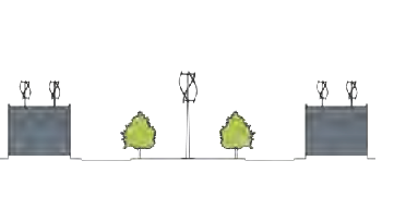 | Quantity: 1 per 4,000 square feet of lot area
T3-S: Power output limited to 10kw All other zones: Power output limited to 100kw | T1, T3-S, RMX, IC, LI |
| 3. Vertical Access Wind Turbine: A wind turbine with its rotor on the vertical axis. Blades are usually helical and the device is usually more compact than the horizontal axis wind turbine. It does not have to rotate to face the prevailing wind. It is suited for the more urban T-zones because it is significantly smaller than the horizontal axis type — sometimes only 4—5 feet in diameter — and less noisy. These are designed to operate with non-directional wind current, which makes them easier to accommodate and more attractive in urban areas when in proximity to buildings. For further information, see www.quietrevolution.com. | | Quantity: 1 per 1,000 square feet of roof area
T3: Power output limited to 10kw All other zones: Power output limited to 100kw | T3, T4, T5, RMX, IC,, LI |
| 4. Public Furniture: Applications where wind turbines may be located within a public right-of-way. | Location: Must be incorporated into approved street section (see Appendix C). | T4, T5, RMX, IC |
A.
Applicability: Wind turbines are considered accessory uses and are permitted in the zoning districts stated in the above chart. Any structure in the historic district that is visible from the street must be approved by the Historic District Review Board (Section 10.7).
B.
Location and Setback:
1.
No small wind energy facilities shall be located between a principal building and any adjacent streets.
2.
Setbacks shall be the same as the primary structure unless noted otherwise in the chart above. This includes setbacks for guy wires and other support devices if needed.
3.
Wind Farms shall not be permitted in T1 districts adjacent to the historic district.
C.
Height: The system shall comply with the maximum height standards for the zone in which it is located. Units may be angled but shall not be elevated above the roofline of the structure on which it is mounted.
D.
Sound: Sound produced by the wind turbine under normal operating conditions, as measured at a lot line, shall not exceed 55 dBA. The 55 dBA sound level, however, may be exceeded during short-term events that occur beyond the property owner's control, such as utility outages and/or severe wind storms.
E.
Appearance: The wind turbine and tower shall be painted or finished in the color originally applied by the manufacturer, or a matte neutral color (e.g., gray, white, or galvanized steel).
F.
Blade Clearance: The blade tip or vane of any small wind energy facility shall have a minimum ground clearance of 15 feet above grade, as measured at the lowest point of the arc of the blades.
G.
Lighting: No illumination of the turbine or tower shall be allowed, unless required by the FAA.
H.
Access to Tower: Any climbing rungs shall be removed to a height of 12 feet above grade.
I.
Signage Prohibited: Signage visible from any public street is prohibited, except for manufacturer's or installer's identification, appropriate warning signs, or owner identification not to exceed 40 square feet.
J.
Abandonment: On determining that a small wind energy facility has been inoperable for 180 days or more, the Administrator shall send the property owner notice requiring restoration of the system to operating order within 180 days after receiving the notice. If the owner fails to restore the system to operating condition within the authorized time frame, the owner shall be required, at the owner's expense, to remove the wind turbine from the tower for safety reasons. If the owner fails to remove the wind turbine from the tower, the city may pursue legal action to have the wind turbine removed at the owner's expense.
8.5.2 - SOLAR ENERGY SYSTEMS
| SOLAR ENERGY TYPES | DIAGRAM | ZONING
DISTRICT |
|---|---|---|
| 1. Solar Farm: A series of solar panels that may be either ground-mounted or roof-mounted. | 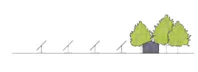 | T1, LI, RMX |
| 2. Roof Mounted Solar Panels: Panels that are either mounted on a sloped roof or flat roof. | 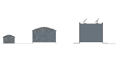 | all zones |
| 3. Public Furniture: Applications where solar panels may be located within a public right-of-way. | 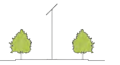 | all zones |
A.
Applicability: Solar energy systems are considered accessory uses and are permitted in the Zoning Districts stated in the above chart. Any structure in the Historic District that is visible from the street must be approved by the Historic District Review Board (Section 10.7).
B.
Height: The system shall comply with the maximum height standards for the zone in which it is located. Units may be angled but shall not be elevated above the roofline of the structure on which it is mounted.
C.
Nonconforming Structure-Height: Where an existing structure exceeds the applicable height limit, a solar energy collection system may be located on its roof, irrespective of applicable height standards, provided the system extends no more than 5 feet above the roof surface.
D.
Easements: The property owner shall be responsible for negotiating with other landowners in the vicinity to establish any solar easement designed to protect solar access for the solar energy collection system.
8.5.3 - FOOD PRODUCTION
| FOOD PRODUCTION TYPES | DIAGRAM | SPECIFICS | ZONING
DISTRICT |
|---|---|---|---|
| 1. Farm: A primary or secondary use for a property. See Section 3.2 for primary use applications. Typically, a farm is a parcel of land where the majority of the acreage is devoted to crop production. | 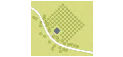 | T1, T3, LI, IC | |
| 2. Vegetable Garden: Small portion of a residential parcel devoted to growing food. | 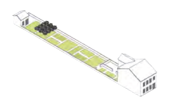 | Location: These are typically situated behind the primary structure. In T3 zones, they may also be in the front, provided that they are well-maintained. | T3, T4, IC |
| 3. Community Garden (a.k.a. Allotment Garden): A mid-block area, typically divided into plots for the surrounding residents to grow food. These gardens provide a locus of recreation and sociability greater than that of the private yard, being one of the so-called third places. | 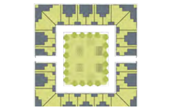 | Management: These are not privately owned, and are typically managed by a municipality, non-profit, or association. | T3, T4, T5, RMX, IC |
| 4. Urban Farm: An area fronted by houses used for growing crops. It may be leased to one farmer, or split into plots for use by the residents. These may be temporarily created on vacant lots, or planned as part of block redevelopments or new neighborhoods. | 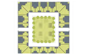 | Management: These are not privately owned, and are typically managed by a municipality, non-profit, or association. | T4, T5, RMX, IC |
| 5. Green Roofs & Container Gardens: Areas within and on a building/parking area, utilized for growing spaces. Green roofs consist of areas on tops of flat roofs that are used for gardens. They also mitigate carbon emissions and reduce storm water runoff. Container gardens, such as window boxes or balcony gardens, create small places for food production while enhancing the urban realm. | 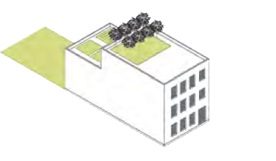 | T4, T5, RMX, IC, LI |
This table shows ways of incorporating types of local food production in different zoning districts. Cities are increasingly allowing urban agriculture for household use, to encourage lower-cost food supplies and reduction in the energy consumption for food transport.
A.
Applicability: Food production is considered an accessory uses, except as noted above in "Farms," and is permitted in the zoning districts stated in the above chart.
B.
Open Space Requirement: These food production areas may be counted toward the Civic/Open Space allocation if they are open to the neighborhood at predictable hours or are visible from an adjacent Civic/Open Space in a way that contributes to the enjoyment of that Civic/Open Space (Section 7.4.3).
C.
Location and Setback: These may encroach into any side and rear setbacks. They may encroach into front setbacks in T3 districts, and in other districts, at the discretion of the Administrator. Associated structures must meet the setback requirements for accessory structures per the zoning district (Sections 2.4.1 C. and 2.4.2 D.).
D.
Animals: Rules on animals related to food production are located in the city's Code of Ordinances, Chapter 4.