
Beaufort City Zoning Code
7
LAND DEVELOPMENT This content was modified in this version of the code. modified
7.6: - APPEALS
See Chapter 9.17 for overall specifications regarding appeals.
(Ord. No. 2025/14, Exh. A, 8-19-2025)
7.1.1 - PURPOSE
The purpose of these land development requirements is to:
A.
Encourage economically sound and environmentally sensitive development.
B.
Assure the timely provision of required streets, utilities, and other facilities and services to new land developments.
C.
Assure the adequate provision of safe and convenient vehicular and pedestrian traffic access and circulation in and through new land developments.
D.
Assure the provision of needed open spaces and building sites in new land developments through the dedication or reservation of land for recreational, educational, and other public purposes.
E.
Assure, in general, the wise and timely development of new areas, in harmony with the Comprehensive Plan of the city.
F.
Encourage new subdivision developments that complement the City's historic development pattern.
G.
Promote compact, well-defined, sustainable neighborhoods that enhance the City's character.
H.
Create livable neighborhoods that foster a sense of community and reduce dependency on vehicles.
I.
Encourage the proper arrangement of new streets in relation to existing or planned streets and ensure streets facilitate safe, efficient, and pleasant walking, biking and driving.
(Ord. No. 2025/14, Exh. A, 8-19-2025)
7.1.2 - APPLICABILITY
A.
Unless noted otherwise in this section, all new development projects shall be required to have public sewer and underground wiring, and shall comply with Section 7.2.3 (Lot Access Standards).
B.
Installation or construction of the improvements specified in the Table of Required Improvements (Section 7.1.3) is required for all development projects, except those which (1) are subject to the Minor Development Design Review or Minor Subdivision provisions of this Code or are located in the Historic District and (2) affect less than one whole Block Face.
C.
The Applicant, developer, and real property owner shall be responsible for the installation and construction of required improvements according to the provisions of this Code, except as may otherwise be specifically provided herein or by agreement.
D.
A Final Subdivision Plat shall not be approved unless the improvements required by this Chapter have been installed or constructed or the Applicant has made improvement guarantees, pursuant to Section 7.1.5, to the satisfaction of the City, for the installation of said improvements.
(Ord. No. 2025/14, Exh. A, 8-19-2025)
7.1.3 - TABLE OF REQUIRED IMPROVEMENTS
A.
Street Improvements: Land designated for public streets shall be cleared and filled in accordance with the latest edition of the "Standard Specifications for Highway Construction" issued by the South Carolina State Department of Transportation, or as determined appropriate by the Administrator. No land may be disturbed until a Building Permit has been issued (Section 9.5). See Section 5.4 for Tree Removal Standards. See Section 7.2 for more standards on street location. See Appendix C for Street Regulating Plan and Design Standards.
B.
Water and Sewer Facilities: Water and sewer facilities shall be provided in accordance with the standard procedures and policies of the water and sewer provider and the South Carolina Department of Environmental Services (SCDES) and shall be approved by the water and sewer provider.
C.
Utility lines: All utility lines within a development site shall be installed underground. The Planning Commission may approve an exception only in cases where there are existing above-ground lines that serve the property.
(Ord. No. 2025/14, Exh. A, 8-19-2025)
7.1.4 - SURVEY AND ENGINEERING
A.
Installation of Permanent Reference Points: Permanent reference points shall be placed in accordance with the following requirements:
1.
General Standards: Boundary surveys shall be performed, in accordance with the state minimum standards published by the State Board of Registration for Professional Engineers and Land Surveyors, unless more stringent requirements are specified. A minimum of two points in any survey must be tied to the state plane coordinate system. The survey may be done on the horizontal ground distance and tied back to the state plane coordinates.
2.
Control Monuments: Vertical control monuments shall be placed in or near the centerline of pavement of subdivision streets at a minimum of 1 per 4 acres. Where practical, control monuments shall be placed at points of curvature and points of tangency of curves. The control monument may be poured on the job or be a concrete marker of the type commonly used in the area: at least 3 feet long and tapered with a 12-inch long, ¼-inch diameter brass or bronze rod embedded in the top. Control monuments shall be placed in a cast iron water main valve type box with a cover flush with the pavement.
3.
Property Marker: A steel or wrought iron pipe, rebar, or the equivalent, not less than 0.5 inches in diameter and at least 24 inches in length shall be set at all property corners and points of curves, except those located by monuments. They shall be flush with the ground.
4.
Accuracy: Land surveys within the city limits shall be Class A surveys, set at an accuracy of at least 1:10000.
(Ord. No. 2025/14, Exh. A, 8-19-2025)
7.1.5 - IMPROVEMENT GUARANTEES
A.
Types Allowed: Prior to approval of a Final Subdivision Plat (Section 7.5.5) the Applicant shall provide a performance guarantee to ensure the completion of required improvements within a period of time as agreed upon by the Administrator and the Applicant, and expressed in the guarantee. Such guarantee may be in the form of a performance bond, a surety bond, a cash deposit, or a letter of credit. A performance guarantee shall be posted in the amount of 125 percent of the total cost of improvements.
1.
Performance/Surety Bonds and Letters of Credit: The performance or surety bond, or letter of credit, shall be in a form acceptable to the City. It shall include a pledge by the bank, insurance company or other bonding/lending institution that the funds necessary to carry out the terms of the agreement are guaranteed for payment and will be released only upon receipt of written instruction from the city.
2.
Cash Deposits: If the surety is in the form of a cash deposit with the City, proportional parts thereof shall be refundable in relation to progress payments less retainage, subject to approval of the City and subject to a minimum deposit balance of 25 percent of the project cost.
3.
Maintenance Guarantees: If the Applicant completes all required improvements and complies with all conditions of the subdivision agreement as determined by the City, the remainder of monies retained by a financial institution or by the City may be released to the Applicant or his successor in title. Prior to release, the Applicant shall provide the City, prior to the issuance of any building permit, a performance bond, a surety bond, or a cash deposit equal to the amount determined by the City to be necessary to ensure the repair of any damage to the existing improvements during the course of any construction, but in no case will the amount of the security be less than $1,000.00 for each individual building lot. Prior to the issuance of any certificate of occupancy, the city shall determine whether or not any breakage or damage has occurred. If no damage to any off-site improvements has occurred, then the city may release the security to the Applicant or his successor in title. If damages have occurred, they shall be repaired, or the city may draw on the security before it is released.
(Ord. No. 2025/14, Exh. A, 8-19-2025)
7.1.6 - EASEMENT AND UTILITY STANDARDS
A.
Multiple installations within easements: Easements shall be designed so as to provide efficient installation of utilities. Public utility installations shall be located as to permit multiple installations within the easements. The developer will establish final utility grades prior to utility installations. Public utility easement dedication shall be required with any minor or major subdivision action.
B.
Underground utilities: Telephone lines, electric lines, cable television lines and other like utility services shall be placed underground. The Applicant and developer shall be responsible for complying with the requirements of this Section and shall make the necessary arrangements including any construction or installation charges with each utility provider for the installation of such underground facilities. Transformers, switching boxes, meter cabinets, pedestals, ducts and other facilities necessarily appurtenant to such underground utilities shall be placed underground or on the surface but not on utility poles. Screening or fencing is required and subject to approval of the City. Electric transmission and distribution feeder lines and necessary appurtenances thereto may not be placed above ground unless they are carrying greater than 115 kV. Upon approval of the City, such facilities shall be placed within easements or rights-of-way provided for particular facilities.
(Ord. No. 2025/14, Exh. A, 8-19-2025)
7.2.1 - STREET INFRASTRUCTURE PLANS
A.
Purpose and Intent: The Street Infrastructure Plans in Appendix C provide diagrams of the City's street network and establish the ideal alignment, hierarchy and design characteristics - including total right-of-way width, sidewalk and streetscape amenities, parking lanes, travel lanes and other geometric and urban design details - for all existing streets, proposed streets that have been adopted as part of an Official Map, and new potential streets in the City.
B.
Official Street Network Plan: Pursuant to S.C. Code § 6-7-1210 et seq. (1976), as amended, the City has previously adopted several Official Maps. An Official Street Network Plan is incorporated into this Code in Appendix C.2 to represent a composite of these previously-adopted Official Maps.
1.
Purpose: This plan represents a composite of all Official Maps, to date, in the City. The map designates existing or proposed streets or ways within the City that are targeted for creation, expansion or other improvements. The Official Street Network Plan shall initially consist of a series of four (4) separate maps, included in Appendix C, which shall be deemed a part of this Code.
2.
Modification: The Official Street Network Plan may be modified or supplemented pursuant to the procedure for Text & Map Amendments (Section 9.16). In addition, the maps will be automatically updated as additional Official Maps are approved pursuant to the appropriate process required by state law.
C.
Street Frontage Requirements: The provisions regarding street sections in Appendix C show specific street designs for the purpose of identifying future improvements by both the City and fronting property owners. These sections depict the ideal arrangement and design of street elements.
1.
Applicability: For any project that is considered part of a Major Subdivision Site Plan, requires a Certificate of Appropriateness as a Major project type (Section 9.10.2.A.2), and/or which affects one whole Block Face, the fronting property owner shall install all prescribed streetscape improvements as part of the development project. The installation of street frontage improvements shall be a condition of Final Plat approval for Major Subdivisions and Certificates of Occupancy for Site Plans, including, as necessary, improvement guarantees under the authority of Section 7.1.5.
Exception: If similar elements as prescribed in the street section exist — e.g. on-street parking, sidewalk, tree plantings — the requirement to install the streetscape element(s) shall be waived if those items meet the intent of the prescribed street section, even if the existing items do not meet the exact requirements of that street section. Example Scenarios: If a street section prescribes a 5-foot sidewalk, but a 4-foot sidewalk already exists, the existing sidewalk will satisfy the sidewalk requirement. However, if the street section requires a 5-foot planting strip between the curb and the sidewalk, and the 4-foot sidewalk is directly adjacent to the curb, this would not satisfy the intent of the street section and would need to be reconstructed per the prescribed standards.
2.
Scope of Improvements: Street frontage improvements shall be installed along the entire frontage of the property to the centerline of the street or, if a multi-lane street, the affected lane, at the sole cost of the Applicant as directed by the Administrator.
a.
Street frontage improvements may include the following: curb, gutter, sidewalk, storm drainage, street lighting, traffic signal equipment, utility installation, extension, or relocation, landscaping strip, street trees and landscaping, irrigation, street widening, pavement overlay or reconstruction, and channelization.
b.
In addition to required frontage improvements, the Applicant shall provide ramps from the new sidewalk or walkway to the existing shoulder, across streets and pavement and channelization tapering back to the existing pavement and channelization as required to address safety concerns.
D.
Dedication of Right-of-Way: In the case of a street section adopted as part of an Official Map, where the width of the existing right-of-way is insufficient to install the prescribed street section, the fronting property owner shall be required to reserve the appropriate amount of right-of-way (as measured from the centerline of the existing street). The future right-of-way shall conform to all of the street network requirements of Section 7.2.2. Where a new right-of-way that is not shown in the Street Regulating Plan is required as part of a new development, it shall be designed with appropriate elements based on its proposed location and zoning district. (See Appendix C).
1.
In the case of a street section that is not part of an Official Map, where the width of the existing right-of-way is insufficient to install the prescribed street section, the property owner shall reserve the appropriate amount of right-of-way to complete the desired street section. If the owner dedicates and installs the complete right-of-way, the cost of the improvements may be borne by the City (see Section 7.2.1.E).
2.
Where an area is designated as a future right-of-way and identified on an Official Map, new development shall reserve this area for the new street in the future. If access is needed to the site in that location, the street shall be constructed in the general location shown.
a.
Exceptions and Alternatives: Where the available rights-of-way — do not functionally permit the full section to be constructed due to existing structures or topographic conditions limited to wetlands, specimen and landmark trees, the Administrator may adjust the requirements for the street section.
E.
Compensation: When a project is required to make off-site improvements within the existing right-of-way, dedicate and/or improve a street with insufficient right-of-way, or install a new street (be it public or private) per the requirements in Section 7.2.1.C, above, compensation of the developer for the costs associated with such improvements may be available at the City's discretion. To the extent that the City has the authority and the ability to do so, the Traffic Impact fee for the project shall be reduced by the assessed value of the dedicated land and/or construction cost of the right-of-way improvement. This may be done either as a direct reduction, rebate, or reimbursement of fees.
(Ord. No. 2025/14, Exh. A, 8-19-2025)
7.2.2 - STREET NETWORK REQUIREMENTS
A.
Continuation of Adjoining Street System: The proposed street layout shall be coordinated with the street system of the surrounding area to form an interconnected street pattern, formalized by a platted public access easement. The adequacy of street connectivity shall be assessed by the Technical Review Committee ("TRC") based on the ability of the proposed alignments to:
1.
Permit multiple routes between origin and destination points;
2.
Diffuse traffic; and
3.
Shorten walking distances.
B.
Block Sizes: Blocks shall be compact so that they are comfortably walkable and appropriate for their context.
1.
In T3-S zones, block sizes are flexible, but the perimeter shall not exceed 2,640 linear feet (½ mile). An average block perimeter of less than 2,000 feet is preferred.
2.
In T3-N zones, block sizes are flexible, but the perimeter shall not exceed 1,700 linear feet. An average block perimeter of less than 1,500 feet is preferred.
3.
In T4, T5 and RMX zones, blocks shall be no more than 400 feet on any side. An average block length of 250 to 300 feet is preferred. The block perimeter shall not exceed 1,320 linear feet (¼ mile).
4.
Exceptions may be made for natural elements such as wetlands, trees, topography, and cultural resources, to be incorporated into the site design.
C.
Street Stubs: New developments shall connect to any existing street stubs from adjacent properties and stub to all adjacent properties.
1.
Exemptions: Street stubs shall not be required where the Planning Commission finds the conditions listed below would prevent connections:
a.
Topographical conditions: pre-development slopes of 18% or greater.
b.
Environmental conditions: marshes, floodplains, specimen and landmark trees, etc.
c.
Property shape that would not allow for street stubs.
d.
Property accessibility: existing platted subdivision with no stubs.
e.
Incompatible adjacent land uses.
2.
Location: Where multiple connection opportunities exist, street stub connections shall be prioritized in the site design as follows:
a.
Adjacent parcels 20 acres or greater in size.
b.
Adjacent parcels that abut or are traversed by existing or proposed streets.
c.
The Street Network Diagram recommends a street connection (indicated as a proposed street).
3.
Design:
a.
Stub streets and streets intended for extension during future phases shall be constructed to extend to the property line for constructability to adjoining property.
b.
Stub streets shall not exceed 150 feet in length without a paved turnaround (permanent or temporary).
c.
Disclosure: The Final Subdivision Plat shall be recorded depicting that future connection is required at any stub streets and streets intended for extension during future phases. A clearly visible street sign shall be erected at the end of the stub street stating that the street is planned to connect to a future street.
D.
Cul-de-sacs and Dead-end Streets: Dead-end streets and cul-de-sacs are prohibited, except in T-3 and LI zoning districts, where cul-de-sacs or other turn-arounds may be approved by the Planning Commission. Compliance with the following standards must be met in all circumstances:
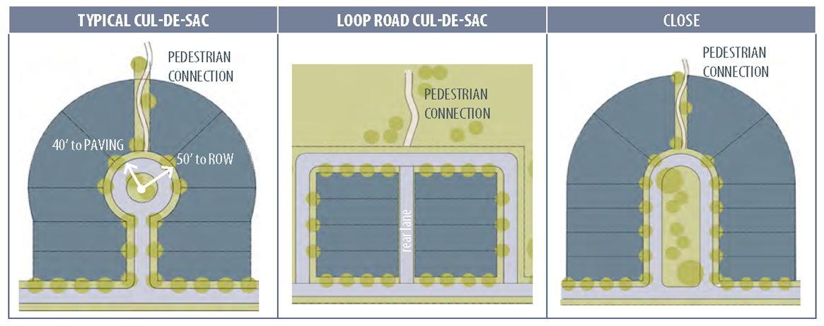
1.
Permanent dead-end streets shall be no longer than 300 feet and shall be provided with a turn-around such as a cul-de-sac or close.
2.
Temporary dead-end streets shall be provided with a temporary turnaround area which shall be designed considering traffic usage, maintenance, and removal.
3.
Alternative design solutions, such as a close (first preference), or a loop road cul-de-sac (second preference) are preferable to a typical cul-de-sac.
4.
Cul-de-sacs shall have a minimum right-of-way radius of 50 feet and minimum paved radius of 40 feet. When ample radii space exists, cul-de-sacs shall contain a central planted median.
5.
Whenever cul-de-sac roads are created, at least one pedestrian access easement shall be provided, to the extent practicable, between each cul-de-sac head or road turnaround and the sidewalk system of the closest adjacent road or pedestrian pathway. The access easement shall be direct with a minimum width of 12 feet.
E.
Gated Streets: New gated streets for new subdivisions are prohibited with the following exceptions:
1.
At the discretion of the Planning Commission, in T3-S zoning districts where connection to the existing street grid is not practicable due to topography or existing surrounding conditions.
2.
At the discretion of the Planning Commission when the access proposed to be gated is an alley or rear lane and is not the primary building frontage.
3.
At the discretion of the Planning Commission, where existing communities own their own streets and have no existing or future street connectivity.
F.
Street Naming and Renaming: New street names and street renaming are subject to the requirements of S.C. Code § 6-29-1200. Proposed Street names and number systems shall be reviewed by and subject to the approval of the Administrator and the Beaufort County Emergency Management Department. No duplicate/similar names are allowed, as determined by these agencies.
G.
Reserved Strips Prohibited: Reserved strips at the terminus of a new street shall be prohibited.
(Ord. No. 2025/14, Exh. A, 8-19-2025)
7.2.3 - LOT ACCESS STANDARDS
A.
Applicability: Any development that requires one or more access points for purposes of ingress and/or egress shall be subject to the provisions of this section. All new access points must be approved by the appropriate permitting authority. Access points may not be installed on undeveloped property less than 2 acres.
B.
Maximum Number: For single-family and two- and three-family dwellings, only one driveway shall be permitted per lot. In T3-S, circular driveways may be permitted on lots greater than 100 feet in width, where no sidewalk exists. Driveways may only be installed when rear access is not possible or required. For double frontage lots, one curb cut per street may be permitted. For all other building types, the maximum number of driveways allowed for any property is outlined in the table below.
C.
Location and Spacing:
1.
Street Intersection: No curb cut or other access point shall be located closer than:
a.
20 feet from the intersecting point of the 2 street right-of-way property lines involved (or such lines extended in case of a rounded corner);
b.
25 feet from the intersection of the 2 curb lines involved (or such lines extended in case of a rounded corner), whichever is the least restrictive.
2.
Spacing: All access points shall have a minimum separation from certain features as follows:
3.
Corner Lots: Access points on corner lots shall be from the side (or secondary) street, unless a shared curb cut on the main thoroughfare is existing or proposed.
4.
Access to Lots from Major Thoroughfares: Driveways serving individual residential lots shall not have direct access onto streets identified as Major Thoroughfares — as identified on the second row of the chart in Section 7.2.3.C.2. — unless no alternative means of access, such as alleys or parallel access roads, exist, and it is unreasonable or impractical to require an alternative means of access.
5.
Shared Access: See Section 5.7.7.C.
6.
Rear Access Required/No Front Access: For lots developed in the transect zones of T3-N, T-4, and T5-UC, all new access points shall be from a rear alley and/or road, except for lots within the historic district. Exemptions to allow front loaded access points where connection to the existing street grid is not practicable due to topography or existing surrounding conditions shall be at the discretion of the Planning Commission with approval of major subdivisions, and the Codes Administrator for individual lots.
D.
Size:
1.
Alleys: Alley pavement width may be a maximum of 24 feet wide for two-way traffic and 16 feet wide for one-way traffic. For more design standards, see Appendix C.
2.
Driveways:
a.
Driveways for single-family and 2- and 3-family uses may not exceed 12 feet wide, except in T3-S district, where they may be a maximum of 20 feet wide.
b.
Tandem Parking: Tandem parking is allowed in all zones for all residential uses if:
i.
Both tandem parking spaces satisfy the parking requirement of one residential unit; and
ii.
Neither of the tandem parking spaces shall be for required accessible parking spaces.
c.
Driveways to other uses and parking areas shall not exceed 24 feet in width for 2-way drives or 12 feet in width for one-way drives, except those with turn lanes required by the City or SCDOT.
E.
Access to Lots from Alleys/Rear Lanes:
1.
Specific to T3-N, T4, and T5 districts: Alleys/rear lanes shall be provided along the rear property lines of lots as follows:
a.
In new subdivisions greater than 1 acre, alleys shall be provided for newly created lots that meet any of the following criteria:
i.
The lots are part of a Block Face with an average lot width of 60 feet or less at the building setback line (excluding lots on cul-de-sacs).
ii.
The lots are arranged around a Common Open Space.
iii.
The lots front a collector or arterial road, regardless of the average lot width.
iv.
The lots are intended for multi-family dwellings and/or mixed-use buildings.
b.
For Infill developments, the same standards apply as specified in the immediately preceding subsection, but only for developments that include 4 or more contiguous lots, where one lot is a corner lot. In the Historic District, the standards apply only to the Beaufort Conservation District; the requirement may be waived at the discretion of the Historic Review Board.
F.
Specific to Commercial Developments and Subdivisions:
1.
Out-parcels: Out-parcels for shopping, office, or industrial centers shall be limited to internal access to the center, unless otherwise approved as part of a master development plan. All driveways shall be paved from the road to the property line.
2.
Abandoned Driveways: Abandoned driveways (i.e., curb cuts that are no longer used for vehicular access and are physically blocked by structures) shall be closed, and the area shall be restored to the typical cross section of the right-of-way.
(Ord. No. 2025/14, Exh. A, 8-19-2025)
7.2.4 - STREET DESIGN STANDARDS
A.
Street Section Design: The elements and widths of all proposed streets shall be in conformity with the appropriate street section designated in the Street Infrastructure Plans (Section 7.2.1 and Appendix C).
B.
Traffic Control and Signs: The type and location of traffic control devices used on City streets must be approved by the Administrator or the Administrator's designee, and traffic control on private streets shall be included and approved as part of the major subdivision or site plan. Traffic signals should be used where warranted, but alternative means of traffic control such as roundabouts should be considered first. When it can be shown that a particular zoning action, master plan, or development plan impacts the street system to a point that a traffic signal is warranted according to the latest version of the United States Department of Transportation's Manual on Uniform Traffic Control Devices ("MUTCD") and approved by the Administrator or the Administrator's designee, the developer shall be responsible for all or a portion of the signal installation.
C.
Sidewalks/Multi-use Paths: Where required by the provisions of Appendix C, all sidewalks or multi-use paths must be constructed concurrently with the street or, if the street is already constructed, prior to acceptance of any improvements. Exceptions to the requirement to install a sidewalk may be granted by the Planning Commission if:
1.
Alternative pedestrian paths/bikeways have been or will be provided outside of the normal right-of-way.
2.
There are unusual topographic, vegetative, or other natural conditions that would render strict adherence to the requirements of this section unreasonable and not consistent with the purposes and goals of this Code.
D.
Utility Easements: Utility easements which require a width of 8 feet or more shall be located in rear alleys or adjacent to rear lot lines. Special permission to install utility easements in other locations may be requested by the utility companies and is subject to approval by the appropriate design review body.
E.
Special Consideration for Protected Resources and other Natural Features: Street layout and design shall give additional consideration to preserving protected resources and enabling natural areas to be protected or minimally disturbed. Where streets are built in areas that have protected resources or natural features, all utilities shall be placed within the street right-of-way and under the street to avoid additional destruction of the natural features.
(Ord. No. 2025/14, Exh. A, 8-19-2025)
7.2.5 - STREET TREE PLANTING REQUIREMENTS
A.
Planting Areas: Planting strips and tree wells shall be established in accordance with the width and plantings designated in the appropriate Street Section of the Street Infrastructure Plans (7.2.1 and Appendix C).
B.
Location and Number: Street trees shall be planted in the location and per the spacing specified for the corresponding street classification in Appendix C. However, in specific cases, where due to the location of utilities or other site constraints, the Planning Commission may allow street trees to be planted on private property adjacent to the right-of-way.
C.
Tree Species: The species of overstory and understory trees listed in Appendix A.2 may be used for street tree planting.
D.
Minimum Tree Size: At the time of planting, young trees should be 2.5 inch caliper, with the lower side of the crown a minimum of 6 feet above grade.
(Ord. No. 2025/14, Exh. A, 8-19-2025)
7.3.1 - STREET DESIGN, CERTIFICATION, AND CONSTRUCTION SPECIFICATIONS
A.
Design Drawings and Certification: Professional engineers, registered in the State of South Carolina, shall prepare plans, profiles, cross sections, and specifications for all subdivision roads and streets. The engineers shall certify that the roads/streets are built to comply with the approved plans and specifications. Cross sections shall be developed every 100 feet at intersections and break points in grade. Cross sections shall show the complete rights-of-way including travel lanes, shoulders, ditches, curb and gutter, and sidewalks and utility locations, as applicable.
B.
Construction Specifications for Paved Streets: Street construction specifications for paved streets shall comply with the South Carolina Department of Transportation Standards.
(Ord. No. 2025/14, Exh. A, 8-19-2025)
7.3.2 - TRAFFIC IMPACT ANALYSIS
A.
Applicability: A Traffic Impact Analysis ("TIA") shall be required for any development that is shown to generate more than 50 trips during the peak hour on the adjacent street(s) in the most recent Institute of Transportation Engineers ("ITE") Trip Generation Manual or any alternative, approved at the discretion of the Planning Commission or the TRC, or by the engineering department.
1.
A second phase, second subdivision, or addition that generates traffic beyond this threshold, when taken as a whole, shall also require a TIA, even though that development may not qualify on its own.
2.
A use shall not be changed without conducting a new TIA if the new use would generate traffic beyond the 50 trips during peak hour threshold referenced above. The Planning Commission may waive this requirement.
B.
Traffic Access Management Analysis: As part of the TIA process, the proposed development shall have an "access analysis" undertaken by the administrator to ensure that sufficient access to all proposed developments and subdivisions is achieved.
1.
The standards in the South Carolina Department of Transportation's "Access and Roadside Management Standards Manual" ("ARMS Manual") shall serve as a guide for this analysis, which shall include identification of the following:
a.
Access improvements, such as deceleration lanes, that the Applicant must install at the Applicant's own expense;
b.
The location of any curb cuts based on, but not limited to, sight distances, existing roadway infrastructure, opposing driveways locations, and shared access;
c.
Requirements for adequate driveway design, including, but not limited to, turning radius and stacking distance.
2.
The access requirements approved by the Planning Commission or the TRC shall be incorporated on development or subdivision plans prior to their approval.
3.
If an Applicant is required to provide site-related traffic improvements, the cost of implementing such improvements shall be borne by the Applicant, and no such costs shall be eligible for a credit or offset from any transportation impact fees unless specifically permitted by the Development Fee Procedures as stated in the Beaufort County Code of Ordinances, Chapter 82, Article II or most recent version.
C.
Traffic Impact Analysis Plan Preparation:
1.
The TIA shall be conducted by an engineer registered in South Carolina who is experienced in the conduct of traffic analysis.
2.
Prior to beginning the TIA, the Applicant shall supply the City with the following:
a.
A written narrative describing the proposed land use(s), size, and projected opening date of the project and all subsequent phases.
b.
A site location map showing surrounding development within a one mile radius of the property under development consideration.
c.
A proposed site plan or preliminary subdivision plat illustrating access to public or private roads and connectivity to other contiguous developments.
3.
Prior to beginning the TIA, the Applicant shall receive, in writing, the parameters to be followed in the study, including the directional split of driveway traffic, trip distribution, background traffic growth rate, previously approved but not completed projects, and the intersections to be analyzed, along with any associated turning movement counts that are available or discussed and approved by the TRC.
4.
To review the TIA, the Planning Commission and TRC will require current trip generation information, available information on land use, travel patterns, and traffic conditions, and shall consult with the SCDOT.
D.
Plan Contents:
1.
Phased Developments: All phases of a development are subject to review, and all traffic plans for the entire development shall be integrated with the overall traffic analysis. A TIA for a specific phase of development shall be applicable to the phase of development under immediate review. However, each phase of development shall expand and provide detailed analysis at the development plan stage beyond the estimates provided for at the concept plan or master plan stage.
2.
Infrastructure Analysis: The adequacy of the roads that the development will be accessed from shall be assessed in the TIA. Recommendations for improvements to these roads shall be made. The relative share of the capacity created shall be broken down as follows: development share, other developments' share, any existing overcapacity, and capacity available for future growth.
3.
Required Elements of the TIA:
a.
A site plan or subdivision plat identifying access points to and from existing or proposed streets and intersections, along with all opposing intersections across adjacent streets.
b.
Description of the proposed development, including the type and intensity of proposed land use(s) including, but not limited to: the number of residential units by type, the number of existing and proposed lots, the type of proposed nonresidential development and the amount of such development measured by gross floor area or other appropriate unit of measurement, the general size and type of accessory development or facilities, and, for nonresidential development, adequate information to identify the appropriate land use category for trip generation.
c.
Projected vehicular trips to and from the completed development during a.m. and p.m. peak hour — trip rates shall be taken from ITE Manual or alternatively, an Applicant may elect to perform, at his own expense, a trip generation study which may be submitted as part of the TIA plan. The trip generation study shall be subject to the review and verification of the TRC and engineer. For proposed uses not specifically listed in the ITE Manual, and for which a trip generation study has not been performed, the designated engineer(s) shall determine the most appropriate trip generation rate. The TRC shall make the determination of the appropriate trip generation rate, from whatever the source. The percentage of pass-by trips, if used in the plan, shall be included, as well as the source of this information.
d.
A written narrative setting forth the assumptions upon which any projection was made in developing the TIA plan shall be included in the analysis. If the assumptions are derived from the ITE Manual, the materials shall be referenced and properly cited. If the assumptions are not from the ITE Manual, appropriate excerpts from other reliable transportation planning resources shall be included in the study, and reasons underlying the assumptions shall be stated in the narrative.
e.
The TIA shall review access to the site. The adequacy of the entrance design shall be evaluated, and recommendations made on acceleration and deceleration lanes, left-turn lanes, or signalizations shall be part of the TIA. Educational facilities shall include pick-up and drop-off plans and analysis of the impact on the surrounding streets and intersections.
f.
The TIA shall review the number and types of curb cuts that are permitted. In particular, the TIA shall assess the connection of the property to adjoining properties. Where the use, scale of development, or size of adjoining properties is such that trips would be anticipated between the proposed use and the other properties, the TIA shall make recommendation on interconnections. The TIA shall recommend interconnections to provide a smooth flow of traffic between uses along arterials and collector roads to ensure that as much traffic as possible uses secondary roads, rather than major roads, for short trips.
g.
The TIA shall be based on intersection analysis procedures for signalized intersections as identified in the most current edition of the Transportation Research Board's Highway Capacity Manual, and/or the last update that analyzes and emulates these procedures by means of computer software, if available. The results of any required analysis/computer analysis shall, at a minimum, indicate compliance or variance from the Traffic Service Level Goals (Section 7.3.2.M).
h.
The intersections that must be analyzed in the study are identified as:
i.
Any intersection that serves as a development's point of access. This will include intersections of public and/or private roads with major arterials, and driveways offering direct access.
ii.
The first major intersection as identified by the Code Administrator on both sides of the development's point of access.
iii.
Other intersections on major arterials if development generates more than 50 a.m. or p.m. peak hour trips to that intersection, or if the intersection's level of service or demand is significantly impacted by site related traffic.
iv.
Unsignalized intersections and access drives — these shall be considered if development impacts are anticipated. The plan must include the results of an analysis of the operating conditions of critical intersections and/or all intersections identified in the concept plan. The analysis shall reflect the projected condition of these intersections and movements, based on the scheduled opening date of the development. Other phases of the development, if they can be reasonably determined, shall be considered as well.
E.
Mitigation Plan Required: If the initial analysis indicates that the city's adopted Traffic Service Level Goals (Section 7.3.2.M) will not be met, a mitigation plan must be prepared, based on additional analysis. The mitigation plan must show how the city's Traffic Service Level Goals are addressed as mitigated. Applicants will be responsible for mitigating the traffic impacts at any intersection affected by a proposed development.
1.
If a traffic signal is recommended, the TIA shall provide information that:
a.
Clearly indicates the need for a traffic signal.
b.
Assesses the ability of other existing, planned, or proposed public roads to accommodate the new traffic at a location other than the main highway in the vicinity of the proposed development.
c.
Describes in detail how a specific development will affect the study area transportation system.
d.
Provides documentation of appropriate South Carolina Manual of Uniform Traffic Control Devices signal warrant satisfaction.
e.
Gives design geometry of the private road that is consistent with that of public road intersections, including curbs, appropriate lane widths, pavement markings, and vertical alignment. Other roadway factors to be considered include, but are not limited to, speed, type of highway, grades, sight distance, existing level of service, conflicting accesses, and the effect of future traffic signal systems.
f.
Provides an approach-throat length for the road to ensure the movement of vehicles entering the site will not be impeded by conditions within the development and ensure that all signal-spacing requirements are adequately met.
2.
The desirable spacing of signalized intersections on principal arterials is the SCDOT, county, or City standards. The TRC may recommend to SCDOT the installation of a traffic signal at locations where, using SCDOT standards, spacing is inappropriate due to topography, existing or proposed road layout, documented accident history, unique physical constraints, existing or proposed land use patterns, or requirements to achieve specific objectives for highway segment designations, as shown in any locally adopted land use or transportation plan, approved City or county transportation plan, or approved transportation policy.
3.
Signal spacing concerns may be ameliorated in the following ways:
a.
A proposed private road that may otherwise be considered for the installation of a traffic signal may be replaced by an on-site route or a frontage road that directs traffic to or from a nearby public road.
b.
A private road that is being considered for traffic signal installation may be required to connect to the existing or planned local road system to allow uses of surrounding properties.
c.
An existing or proposed intersection may be relocated.
d.
A shared private road may be required to serve the needs of the multiple properties.
4.
A traffic signal progression analysis is required if the proposed location is closer than the SCDOT standards, given the presence of existing signals or the possible existence of identified future signals proposed as part of a highway signal system. A traffic signal progression analysis for all new, revised, or planned traffic signal systems on state highways shall be performed using methods, models, computer software, data sources, roadway segment length, and assumptions approved by the TRC. The roadway segment, analyzed to the extent possible, shall include all traffic signals in the existing or future traffic signal system. The progression analysis shall:
a.
Demonstrate acceptable existing and future traffic signal systems operation that may include the morning peak, evening peak, midday period, and other appropriate time period during any day of the week, adjusted for peak season, for cycle lengths and travel speeds approved by the TRC.
b.
Provide for a progressed traffic band speed no more than 5 mph (8 km/h) below the existing posted speed for both directions of travel during the off-peak periods, nor more than 10 mph (16 km/h) below the existing posted speed during peak periods. Approval by the TRC is required where speeds deviate more than the above.
c.
Demonstrate that sufficient vehicle storage is available at all locations within the traffic signal system without encroaching on the functional boundaries of adjacent lanes and signalized intersections. The functional boundary of an intersection shall be determined in discussion with the TRC, based on existing or projected conditions.
d.
Provide a common cycle length with adequate pedestrian crossing times at all signalized intersections.
e.
Provide a progression bandwidth as large as that required, or as presently exists, for through traffic on the federal or state highway at the most critical intersection within the roadway segment. The most critical intersection is the intersection carrying the highest through volume per lane.
5.
The traffic signal progression analysis shall be supplemented by a traffic engineering report that also considers highway capacity and safety of the roadway segment under consideration. Traffic volumes, intersection geometry, and lane balance, considered at all locations, shall be appropriate for the present and identified future conditions, which are usually considered to include the year of completion, and 5 years into the future.
F.
Summary: A clear and concise summary of recommended improvements that can serve as an executive summary is required.
G.
TIA Review: The TRC shall review all TIAs as part of the applicable Design Review phase. Final TIAs shall be approved prior to the Applicant submitting a Project Permit application (Section 9.5).
H.
Application: A TIA shall be submitted to the TRC. Coordination with other entities in the county government or South Carolina Department of Transportation (SCDOT) shall be the responsibility of the City.
I.
Completeness: The Planning Commission or TRC shall determine whether a TIA is complete. Thorough and complete TIAs are the responsibility of the Applicant. Failure by the Applicant to provide a complete TIA may result in review delays for its plat or plan.
J.
Action on TIA: The TRC must first approve the TIA in regard to completeness and accuracy. Following review of the required impact analysis plan, TRC shall recommend to the Planning Commission for its Final Approval action as follows:
1.
Approval of the TIA as submitted;
2.
Approval of the TIA with conditions or modifications as part of the development review and approval process. An acceptable TIA with traffic mitigation measures may include the reduction of the density or intensity of the proposed development, phasing of the proposed development to coincide with state and/or county-programmed transportation improvements, Applicant-provided transportation improvements, fees in lieu of construction, or any other reasonable measures to ensure that the adopted traffic service-level goals are met. If mitigation is required, it shall be required as a condition of any approval from the city.
K.
Timing of Implementation: If a traffic mitigation program is part of an approved TIA, the developer may be required to place a performance bond on all traffic mitigation improvements required as a result of the project. This requirement may arise if the timing of the improvements needs to be synchronized with other scheduled improvements anticipated for the area.
L.
Responsibility for Costs of Improvements: The costs of implementation of an approved mitigation program shall be the responsibility of the Applicant. No certificates of zoning compliance or building permits shall be issued unless provisions of the TIA are met.
M.
Traffic Service Level Goals: The average stop time delay in seconds per vehicle for each intersection determined to be critical to the TIA for the proposed development shall be compared to the City's traffic service level goal of "D" for the average delay for all vehicles at any signalized intersection during the a.m. and p.m. peak hours.
(Ord. No. 2025/14, Exh. A, 8-19-2025)
7.4.1 - PURPOSE AND INTENT
A.
Intent: Community Green Space and Community Open Space are intended for the use and enjoyment of a development's residents, employees, or users. These spaces serve to preserve natural areas, ensure access to open areas and recreation, reduce the heat island effect, enhance stormwater quality, and provide community health benefits. Community Green Space and Community Open Spaces are not, by definition, required to be deeded or to be granted via easement to any public entity or municipality. See Section 7.4.5 for ownership information.
B.
Purpose: The purpose of this section is to provide a set of Community Green Space and Community Open Space types and their associated standards to use within all districts. Community Green Space and Community Open Space types in this section are distinct from those areas that are environmentally sensitive and must be otherwise protected as regulated through Chapter 8 (Environmental Protection).
C.
Applicability: See Section 7.1.2.
D.
Community Green Space Definition: An area of grass, trees, parks, trails or multi-use pathways, or other vegetation set apart for recreational or aesthetic purposes within a development. It can be privately or publicly owned.
E.
Community Open Space Definition: Open space is land or water that is undeveloped and not used for residential, commercial, industrial, or institutional purposes. It can be privately or publicly owned, and can include areas like forests, farms, parks, and coastal lands.
(Ord. No. 2025/14, Exh. A, 8-19-2025)
7.4.2 - COMMUNITY GREEN SPACE AND COMMUNITY OPEN SPACE REQUIREMENT
A.
Minimum Requirements: Development in all districts shall preserve the minimum amounts of Community Green Space and Open Space as identified below (see following page):
B.
Areas to be Included in Community Green Space and Community Open Space Calculations: The features and areas identified in Section 7.4.3 shall be credited towards the open space requirements for the purposes of complying with this Chapter.
C.
Areas not to be Included in Community Green Space and Community Open Space Calculations: The following areas shall not be counted toward open space requirements:
1.
Private yards which are not subject to an open space or conservation easement.
2.
Public road rights-of-way or private street easements, including sidewalks located within those rights-of-way or easements.
3.
Open parking areas and driveways for dwellings.
4.
Land covered by structures not designated for active recreational uses.
5.
Designated outdoor storage areas.
(Ord. No. 2025/14, Exh. A, 8-19-2025)
7.4.3 - COMMUNITY GREEN SPACE AND COMMUNITY OPEN SPACE TYPES
The majority of Community Green Space and Community Open Space shall conform to one of the 8 types in the table below. If 75% or more of the types listed below are utilized for required open space, a 20% increase in number of dwelling units is permitted.
| CIVIC/
OPEN SPACE TYPE | DIAGRAM | DESCRIPTION | PERMITTED
DISTRICTS | SERVICE AREA | CHARACTER | TYPICAL FACILITIES |
|---|---|---|---|---|---|---|
| Regional Park/Natural Preserve |  | A natural preserve that is available for unstructured recreation. It may contain small civic buildings and areas of structured activity, but is primarily left natural. These areas may include forests as well as wetlands and regional retention areas if they are treated as amenities (e.g. Port Royal's Cypress Wetlands). | T1 | Regional |
Frontage: Independent
Disposition: Natural, formal or informal | Passive and active recreation, drinking fountains, Community facility < 7,500 gross square feet, paths and trails |
| Sport Complex |  | An open space that consolidates heavily programmed athletic fields and associated facilities. | T1, IC, RMX | Regional |
Frontage: Independent
Disposition: Formal or informal | Passive and active recreation, drinking fountains, community facility < 7,500 gross square feet, paths and trails |
| Community Park |  | An open space that is available for unstructured recreation and a limited amount of structured recreation. It may contain a limited amount of athletic fields. | T3, T4, T5, RMX, IC | Multiple Neighborhoods |
Frontage: Independent
Disposition: Informal | Passive and active recreation, drinking fountains, community facility < 5,000 gross square feet, paths and trails |
| Greenway |  | A linear open space that may follow natural corridors, a greenway provides unstructured and limited amounts of structured recreation. | T1, T3, T4, T5, RMX, IC | Multiple Neighborhoods |
Frontage: Independent or building
Disposition: Natural or informal | Passive and active recreation, drinking fountains, community facility < 5,000 gross square feet, paths and trails |
| Square/Green |  | An open space that is available for civic purposes, unstructured, and limited amounts of structured recreation. It can be located along waterfronts. | T3, T4, T5, RMX, IC | Neighborhood |
Frontage: Building
Disposition: Formal | Passive and active (unstructured or structured) recreation, accessory structure, drinking fountains, community facility < 5,000 gross square feet, paths and trails |
| Plaza |  | A formal open space available for civic purposes and commercial activities, a plaza is typically hardscaped and can be located along waterfronts. | T4, T5, RMX, IC | Neighborhood |
Frontage: Building
Disposition: Formal | Passive recreation, accessory structure, drinking fountains, paths and trails |
| Pocket Park/Pocket Plaza |  | An open space that is available for informal activities in close proximity to neighborhood residences. Pocket plazas are usually paved. | T3, T4, T5, IC, RMX | Neighborhood |
Frontage: Building
Disposition: Formal or informal | Passive recreation, accessory structure, drinking fountains, paths and trails |
| Playground |  | An open space designed and equipped for the recreation of children. A playground may be fenced and may include an open shelter. Playgrounds may be included within other civic spaces. | T3, T4, T5, IC, RMX | Neighborhood |
Frontage: Independent or building
Disposition: Formal or informal | Accessory structure, drinking fountains, paths and trails |
| Notes: 1. The illustration and description of each civic space type is illustrative in nature and not regulatory. 2. The Permitted Districts may be modified per a plan if the project is utilizing the Traditional Neighborhood Development Floating Overlay District (Section 2.8.3). | ||||||
The following provisions apply to the eight (8) Community Green Space and Community Open Space Types listed in the table:
A.
Playgrounds and Community Gardens: These may be incorporated into any of the other Community Green Space and Community Open Space types - except Natural Preserve - or may stand alone.
B.
Waterfront: When Community Green Space and Community Open Space is required, per Section 7.4.2, developments that contain waterfront access should include some type of common access to at least 25 percent of the waterfront. This counts towards the Community Green Space and Community Open Space requirement. When open space is required, for every 10 percent of the waterfront that is allocated for public access, a 5 percent increase in number of dwelling units shall be permitted, up to a maximum of a 20 percent increase.
C.
Illustrative Standards: The columns titled "Diagram," "Description," and "Typical Facilities" of the table of Community Green Space and Community Open Space Types are illustrative only.
D.
Regulatory Standards: The following elements shall be regulatory:
1.
Service Area: Describes how the space relates to the city as a whole and the area that will be served by the Community Green Space and Community Open Space.
2.
Size: The permitted size for each Community Green Space and Community Open Space.
3.
Frontage: The relationship along property lines of a Community Green Space and Community Open Space to adjacent buildings or lots.
a.
Building: Community Green Space and Community Open Spaces that are listed as having a "building" frontage shall have the fronts of buildings, either attached to the park or across a street, facing onto the space for a minimum of 75% of the perimeter.
b.
Independent: Community Green Space and Community Open Spaces that are listed as having an "independent" frontage shall have the fronts of buildings, either attached to the park or across a street, facing onto the space to the maximum extent possible, but may have the side or rear of a building or lot front onto the space. The side or rear of a building or lot fronting onto the Community Green Space and Community Open Space shall be designed with a secondary frontage and entrance along the space.
4.
Disposition: The character of the design of the Community Green Space and Community Open Space.
a.
Natural: Civic spaces with natural character are designed in a natural manner with no formal arrangement of elements.
b.
Formal: Civic spaces with a formal character have a more rigid layout that follows geometric forms and have trees and other elements arranged in formal patterns.
c.
Informal: Civic spaces with an informal character have a mix of formal and natural characteristics.
5.
Food Production: Community Gardens and other Community Green Space and Community Open Spaces may be used to grow food. See Section 8.5.3 for specifications and requirements.
(Ord. No. 2025/14, Exh. A, 8-19-2025)
7.4.4 - DESIGN OF COMMUNITY GREEN SPACE AND COMMUNITY OPEN SPACES
A.
Design Standards for Community Green Space and Community Open Space: Land used as Community Green Space and Open Space shall meet the following design standards:
1.
Location:
a.
Where relevant and appropriate, the land shall be located so as to be readily accessible and usable by residents and users of the development. To the maximum extent practicable, a portion of the open space shall provide focal points for the development.
b.
Common space set aside for children's play areas and other recreational activities shall be clearly visible from the dwelling units on the site.
c.
The land shall, to the maximum extent practicable, be located to adjoin, extend, and enlarge any open areas, trails, parks, or other open space resources that exist or are planned within or adjacent to the development.
2.
Provision in Multi-Phase Developments: In multi-phase developments, open space Manuals may be calculated either by phases, or by collectively looking at the developments as a whole.
B.
Accessory Structure Standards: All accessory structures within parks and open spaces — including, but not limited to, restrooms, open-air pavilions, gazebos, picnic shelters, and outdoor theaters — shall not be subject to the physical requirements of the building form or siting standards in Chapter 2 (Map and Districts). They shall be designed to be consistent with the character of the district in which they are located. Such consistency may require accessory structures to maintain building setbacks, frontage, massing, disposition, and character similar to adjacent development as determined by the administrator.
(Ord. No. 2025/14, Exh. A, 8-19-2025)
7.4.5 - OWNERSHIP AND MAINTENANCE OF COMMUNITY GREEN SPACE AND COMMUNITY OPEN SPACE
A.
Open space areas or other community facilities shall be preserved and maintained in accordance with the approved:
1.
Development Design, in accordance with Section 9.8;
2.
ZBOA Special Exception, in accordance with Section 9.13; or
3.
Subdivision, in accordance with Section 9.9, whichever is appropriate.
B.
Provision must be made by the property owner to ensure preservation and long-term maintenance and management of Community Green Space and Community Open Spaces through one of the following mechanisms:
1.
Conveyance of the land to a property owners' or homeowners' association that holds the land in common ownership and will be responsible for managing and maintaining it for its intended purposes.
2.
Conveyance of the land to a third-party beneficiary, such as a nonprofit environmental or civic organization, that is organized for, capable of, and willing to accept responsibility for managing and maintaining the land for its intended purpose.
3.
Dedication of the land to the city or other appropriate public agency that is organized for, capable of, and willing to accept responsibility for managing and maintaining the land for its intended purposes.
C.
All methods utilizing private ownership shall require deed restrictions, covenants, or other legal instruments that ensure continued use of the land and facilities for their intended uses, and provide for the continued and effective management, operation, and maintenance of the land and facilities.
D.
Failure to maintain Community Green Space and Community Open Space areas or other community facilities shall be a violation of this Code subject to the remedies and penalties in Chapter 12 (Violations and Enforcement).
E.
If the owner of a Community Green Space and/or Community Open Space fails to maintain it in reasonable condition, and in accordance with approved plans, and fails to correct deficiencies cited by the City, the City shall have the authority to correct the deficiencies at the owner's expense.
(Ord. No. 2025/14, Exh. A, 8-19-2025)
7.5.1 - GENERAL PROVISIONS
The provisions of this Section shall apply to any and all subdivision of land, or site plan within the municipal boundaries of the City, unless expressly and specifically exempted or provided otherwise in this Code. No development shall be undertaken without prior approval or authorization pursuant to the terms of this Code. All development shall comply with the applicable terms, conditions, requirements, standards and procedures established in this Section and the Code. The submittal of an application for approval pursuant to the provisions of these Subdivision standards constitutes consent to, and agreement to comply with, all of its applicable provisions.
This Section establishes procedural and substantive rules for obtaining the necessary approval to develop land and construct buildings and structures. Development applications will be reviewed for compliance with the City's Comprehensive Plan, Civic Master Plan, Beaufort Preservation Manual, and this Code.
Scheduling of the review of development applications before Staff, TRC, the Planning Commission or City Council is at the discretion of the City. Any change to a development application by an Applicant after formal submittal of that application to the City constitutes a decision by the Applicant that may result in the City deciding to vacate a decision reached during or following a hearing and/or void the pending application. The City may then reschedule or cancel the review of the development application at its discretion.
Prior to formal submittal of any subdivision application identified in this Section, the Planning Department will provide to an Applicant an individualized submittal checklist indicating the documents and information needed, quantities of those documents to be submitted, and the referral agencies that will be involved in the review process. The Applicants are responsible for being fully familiar with all applicable provisions of these Subdivision Regulations. Upon determination by staff that a submittal constitutes a complete development application, the City will forward the packets to each referral agency.
(Ord. No. 2025/14, Exh. A, 8-19-2025)
7.5.2 - SUBDIVISION TYPES AND PROCESS OUTLINES
Methods of land subdivision. There are two ways to subdivide land based on the magnitude of scale: Minor Subdivision and Major Subdivision.
A.
Minor Subdivisions:
Definition. A Minor Subdivision is a subdivision, or amendment to a subdivision which has been previously platted, which includes no additional public right-of-way dedication, and includes one or more of the following:
1.
The boundaries of five or fewer lots are created from one parent tract or lot, cumulatively and not more than 3 acres;
2.
Any lot line adjustment; or
3.
A consolidation of multiple lots into one when a new street or street change is not involved.
B.
Major Subdivisions:
Definition. A Major Subdivision is a subdivision which includes one or more of the following:
1.
Dedication of public right-of-way, public infrastructure or other public tracts, or a private road;
2.
The subdivision consists of six or more lots or tracts; or
3.
The creation of lots on property which have never previously been platted.
(Ord. No. 2025/14, Exh. A, 8-19-2025)
7.5.3 - SKETCH PLAN
A.
Purpose: The Sketch Plan is a conceptual design of the development submitted with a Major Subdivision application, that depicts what the Applicant envisions for the overall development, including zoning, transportation, pedestrian network, parks, tree canopy, community open space, and other amenities. The purpose is to allow the Applicant, the Planning Commission, and the community the opportunity to discuss the conceptual subdivision before it goes through the major subdivision platting process.
B.
Requirements: A Sketch Plan shall be submitted and provided to staff in advance of any public and/or community meeting for all Major Subdivisions. Major proposed changes to any approved preliminary plat(s) may require a new Sketch Plan review if the Code Administrator determines the changes are significantly different from the Sketch Plan discussed at the public meeting.
The Sketch Plan shall consist of the following elements:
1.
Street plan: The Applicant shall provide a preliminary traffic plan that addresses the following elements:
a.
The proposed street network and connectivity to the existing Street network, including all proposed access points.
b.
The location and layout of all arterial and collector roads within the development.
c.
The scope of a traffic impact study prepared by a S.C. licensed traffic engineer which evaluates proposed access points, the existing street system, and any need for any road improvements (including off-site improvements) created by the proposed development.
2.
Community Open space plan: The Applicant shall provide a preliminary open space plan that depicts compliance with Section 7.4 of this Code, with the following elements:
a.
Proposed Community open space distribution and location, including percentage of open space.
b.
Compliance with Section 7.4.2, Community Green Space and Community Open Space Requirement.
c.
Required buffer areas in accordance with Section 5.5.1.
d.
Wetland areas and setbacks as determined by SCDES-BCM, if applicable.
e.
Proposed park locations, acreage, and types of parks in accordance with Section 7.4.
3.
Pedestrian network:
a.
Location of all trails within development, and connection to existing trail network.
b.
Connectivity of sidewalks to the existing pedestrian system, including any off-site sidewalk improvements. This includes planning for a one-quarter mile pedestrian distance.
c.
Depiction of any bike lanes or any other multi-modal features.
4.
Zoning/Design:
a.
The location of zoning boundaries shall be provided with the application and depicted on the Sketch Plan.
b.
The Sketch Plan should show how the development is consistent with the surrounding area, and within the property itself.
c.
Conceptual building design and massing.
5.
Overall utility plan:
a.
A letter from the appropriate utility, confirming the existing capacity of the surrounding utility system, and the future capacity of the utility system for the proposal. Utility plans for the interior of the development (such as water and sewer service lines) are not required as part of this process.
b.
Proposed connections to the existing utility system.
C.
Sketch Plan application submittal: The application package shall include the following items:
1.
Development application form and fee.
2.
Name of project.
3.
North arrow, scale (not greater than one inch equals 200 feet), and date of preparation.
4.
Vicinity map.
5.
Legal description.
6.
Acreage of property; acreage in each zoning district; acreage in parks; and acreage in open space.
7.
USGS topographic contours.
8.
Location and approximate acreage of proposed land uses.
9.
Existing easements and rights-of-way on or adjacent to the property.
10.
Existing streets on or adjacent to the property (show and label street names).
11.
Table providing the following information for each proposed land use area: total acreage; proposed density; and proposed number of dwelling units and/or commercial buildings.
12.
Location and acreage of proposed open space and parks as per Section 7.4., trails, regional trail connections, playgrounds, and schools or other public uses.
13.
Proposed street system depicting the location and layout of all arterial and collector roads within the development.
14.
The scope of a traffic impact study prepared by a S.C. licensed traffic engineer which evaluates proposed access points, the existing street system, and any need for any road improvements (including off-site improvements) created by the proposed development.
15.
Floodplain boundary with a note regarding the source of information.
16.
Zoning on adjoining properties.
17.
A letter from the appropriate utility, confirming the existing capacity of the surrounding utility system, and the future capacity of the utility system for the development.
18.
Proposed connections to the existing utility system.
19.
The location of any proposed or required lift stations.
20.
Design rationale — description of how the development is integrated with surrounding area, how it responds to site features/constraints and how it is consistent with this Code.
21.
General description of plan for drainage and storm water management, including any regional drainage solutions.
22.
Description of how the proposed development complies with the City's Comprehensive Plan.
23.
Concept of structure location, massing and design.
D.
Application certification of completion: Within 30 days, staff shall either certify the application is complete and in compliance with all submittal requirements or reject it as incomplete and notify the Applicant of any deficiencies. Applicant shall then correct any deficiencies in the application package and re-submit the application to the City.
E.
Sketch Plan Process:
1.
Planning Commission Meeting: The Planning Commission shall hold a public meeting to review and provide comments on the Sketch Plan.
2.
Notice to neighboring property owners: The City shall send advance notice of the Planning Commission meeting by regular mail to neighboring property owners within 1,000 feet of the property per this Code.
F.
Sketch Plan review criteria: The Planning Commission shall use the following criteria in addition to other applicable provisions of this Code to evaluate the Applicant's application:
1.
The land use mix within the project conforms to Beaufort's Zoning District Map and Comprehensive Plan Preferred Land Use Map and furthers the goals and policies of the Comprehensive Plan.
2.
The Sketch Plan is consistent with the rationale and criteria set forth in this Chapter, the City's Comprehensive Plan, and the Civic Master Plan as amended.
3.
The preliminary traffic, open space, park, utility, and pedestrian design is adequate and functional given the existing and planned capacities of each system, and meets the standards found in this Code.
4.
The conceptual design and massing proposed is consistent with the requirements of the Development Code.
G.
Timeframe related to approval of Sketch Plan: After a period of 12 months has passed without submittal of a Preliminary Plat application, the Administrator may require an Applicant to submit a new Sketch Plan application for Planning Commission review.
H.
Minor amendments: A minor amendment to the Sketch Plan may be reviewed administratively if it:
1.
Does not change any land use, or location of any land use.
2.
Does not change the number of lots or density by more than ten percent cumulatively.
3.
Does not contain significant changes in arterial or collector street alignment and/or access points, or other major public elements such as drainage improvements, utility lines or facilities.
4.
Does not change any measurable standard (other than above), such as open space or park area, by more than ten percent cumulatively.
(Ord. No. 2025/14, Exh. A, 8-19-2025)
7.5.4 - PRELIMINARY PLAT
A.
Purpose: The purpose of the preliminary plat is to provide the City with an overall plat and the associated preliminary engineering for the proposed development.
B.
Application process:
1.
Pre-application conference: A pre-application conference with the City is required before the Applicant may submit a preliminary plat application. Topics to be discussed will include:
a.
The provisions of this Code and the applicable requirements;
b.
The application and review process;
c.
Submittal requirements; and
d.
Changes or modifications based on direction from the Planning Commission at Sketch Plan approval.
2.
Application submittal: Following review of the Sketch Plan, the Applicant may submit the complete preliminary plat application to the City. The preliminary plat application package shall be formatted and packaged per the application submittal checklist provided by the City and include the following items in both printed and electronic formats:
a.
Development application form;
b.
Application fee;
c.
Title commitment. The title commitment must be current and dated no more than 120 days from the date of preliminary plat application submittal; and
d.
The preliminary plat that shall provide the following information:
i.
Title of project.
ii.
North arrow, scale (not greater than one inch equals 100 feet) and date of preparation.
iii.
Vicinity map.
iv.
Names and addresses of owners, Applicant, engineers, and surveyors.
v.
Legal description.
vi.
Total acreage of property.
vii.
Existing contours at two-foot intervals (based on USGS datum).
viii.
Name and location of abutting subdivisions or owners of abutting property (if land is not platted).
ix.
Lots, blocks, and street layout (with cross-sections), dimensions and square footage for each lot. Dimensions and square footages may be rounded to the nearest whole number.
x.
Consecutive numbering of all lots and blocks.
xi.
Existing and proposed easements (including rights-of-way) on and adjacent to the property.
xii.
Existing and proposed zoning on and adjacent to property.
xiii.
Approximate location and size of existing sewer lines, water lines and fire hydrants. Approximate location of proposed sewer lines, water lines, and fire hydrants with a letter from BJWSA and the Fire Marshall.
xiv.
Location by field survey or aerial photography of existing and proposed water courses and bodies of water such as irrigation ditches and lakes. Water courses shall include direction of flow.
xv.
Tree Survey with Existing Tree Canopy Survey.
xvi.
Floodplain boundary with a note regarding source of information (if a floodplain does not exist on the property, state this on the plan).
xvii.
The boundaries of proposed phases of the subdivision if the final plat is intended to be submitted in multiple phases.
xviii.
General location of existing surface improvements such as buildings, fences, or other structures which will remain on the property as part of the subdivision.
xix.
Location and acreage of proposed parks, trails, playgrounds, schools or other public uses.
xx.
Location, function, ownership and manner of maintenance of any private open space.
xxi.
Land use table including land uses, approximate acreage of each land use type, percentage of each land use type density (net and gross) and how public dedication requirement will be met.
xxii.
Total number of lots.
xxiii.
Number of each type of dwelling unit proposed.
xxiv.
An AutoCad drawing file of the Preliminary Plat in a format specified by the Codes Administrator.
xxv.
Surveyor's certificate.
3.
Drawing standards: The preliminary plat drawing shall comply with the following standards:
a.
The preliminary plat shall be prepared by or under the direct supervision of a registered land surveyor, architect and/or engineer, shall be signed and stamped by said surveyor, architect and/or engineer, and shall meet applicable State of South Carolina requirements.
b.
Contiguous parcels separated by easements (including public rights-of-way), public tracts, or railroads, parcels not contiguous with each other shall not be included in one plat, nor shall more than one plat be made on the same sheet. Contiguous parcels owned by different parties may be included on one plat, provided that all owners join in the application and acknowledgment.
c.
Lengths on the preliminary plat boundary shall be shown to the nearest hundredth of a foot and bearings shall be shown in degrees, minutes, and seconds.
d.
Bearings, distances and curve data of all perimeter boundary lines shall be indicated outside the boundary line, not inside, with the lot dimensions.
e.
Names and signatures of all owners with any interest in the property shall be on the preliminary plat and shall be made in black drawing ink.
4.
Explanation of how the plat is consistent with this Code, the Comprehensive Plan, the Civic Master Plan, and the Sketch Plan.
5.
Preliminary grading and drainage plan and report: This plan and report must be certified by a South Carolina registered professional engineer or Land Surveyor and include approximate earthwork quantities (how earthwork on the site is "balanced"), storm drainage concepts such as locations of pipe and other conveyance facilities, locations for on-site detention or downstream structural improvements, and soil erosion and sedimentation control plans and specifications. It must also discuss the impacts on and to any existing floodways and/or floodplains both on and adjacent to the site as well as any FEMA applications or approvals that may be required.
6.
Preliminary water and sewer plan and study: This plan shall be prepared by a registered professional engineer. It is necessary that the engineer consult with the appropriate utility service providers regarding the design of all utilities through the subdivision.
7.
Preliminary landscape and open space plan: The landscape plan must address the treatment of all exterior spaces. Landscape plans are to be designed to meet the requirements of this Code and show approximate locations of trees, shrubs, groundcovers, turf, buffering, fences, walls and other site amenities that will be included in the plan.
8.
Traffic study: A TIA with requirements consistent with Section 7.3.2. This study must be prepared by a S.C. licensed professional traffic engineer and identify the projected impacts to the local and regional traffic system. The direct roadway impacts and proposed share in the cost of regional improvements and intersections must be identified for the project.
9.
Archaeological Impact Assessment: As determined by the Codes Administrator, an Applicant may be required to provide the City, pursuant to Section 8.4, with records listing historically or archaeologically significant findings on the property being subdivided at the Applicant's expense.
10.
General ecological resource survey: Prepared by an environmental expert, a survey identifying the potential/absence/habitat of a threatened or endangered species and wetlands or other ecologically sensitive area. Said survey shall make practical recommendations regarding treatment or mitigation of the findings.
11.
Conceptual Design: Applicant should provide conceptual design and massing examples (i.e. typical building elevations, but not required for each individual lot), consistent with the requirements of this Code.
C.
Planning Commission Hearing: The Planning Commission shall hold a public hearing to approve, approve with conditions, or deny the Preliminary Plat.
1.
Notice to neighboring property owners: The City shall send advance notice of the Planning Commission hearing by regular mail to neighboring property owners within 1,000 feet of the property per this Code.
2.
Approval: The Planning Commission shall review and act on the Preliminary Plat. The Planning Commission shall approve, approve with conditions, or deny the Preliminary Plat based on the review criteria below.
D.
Review criteria: In addition to all provisions of this Code, the Planning Commission shall use the following criteria to evaluate the Preliminary Plat:
1.
The Preliminary Plat is consistent with the rationale and criteria set forth in this Code.
2.
The land use mix within the project conforms to the City's Development Code and complies with the Comprehensive Plan and Civic Master Plan.
3.
The utility and transportation design are adequate, given existing and planned capacities of those systems.
4.
Lot layout, including structure, location, and design of each lot.
E.
Phasing: The Preliminary Plat shall designate the boundaries of phases for which separate Final Plats will be presented for approval. Each phase, either alone or in conjunction with previously approved and recorded phases, must meet all of the requirements of this Code.
F.
Early grading: After approval of a Preliminary Plat, Applicant may proceed with preliminary grading of the project area if a construction plan set for grading and drainage is approved and a memorandum authorizing grading work is issued by the Codes Administrator. Early grading and storage of construction related equipment is at the risk of the Applicant and no Final Plat approval by the Planning Commission is expressed or implied by any authorization of early grading.
G.
Timeframe related to approval of Preliminary Plat: A Preliminary Plat approval is in full force and effect for a period of two years from the date of approval. Approval will automatically expire at the end of two years unless an Applicant requests in writing a 12 month extension from the Planning Commission prior to termination or submits a completed Final Plat application for all or a portion of the property.
H.
Post approval actions: Prior to issuance of a grading permit, the Applicant shall submit the following documentation to the City:
1.
List of contractors: List of all contractors that will be performing the improvements.
2.
Proof of insurance/business license: Proof of workman's comprehensive insurance and liability insurance for each contractor and business license.
3.
Open space deed restriction: Areas designated as open space shall be protected by a deed restriction or other appropriate method to ensure that they cannot be subdivided or developed in the future and will remain as open space until unless the use is modified by the City.
4.
Construction traffic control plan: Applicant will develop a plan for Codes Administrator or appointee, review that addresses construction traffic, construction water, temporary road closures, street repairs, dust, noise and other construction-related concerns.
(Ord. No. 2025/14, Exh. A, 8-19-2025)
7.5.5 - FINAL PLAT
A.
Purpose: The purpose of the Final Plat is to complete the subdivision of land consistent with this Code.
B.
Application process:
1.
Application submittal: The Final Plat application shall substantially conform to the Preliminary Plat as approved at the public hearing and shall meet all conditions of approval. The Applicant shall submit the completed Final Plat application package to the City. The Final Plat application shall be formatted and packaged per the application submittal checklist provided by the City and include:
a.
Development application form.
b.
Application fee.
2.
Standards: The Final Plat shall comply with the following standards:
a.
All requirements of Section 7.5.4.
b.
The plat shall be prepared by or under the direct supervision of a registered land surveyor, shall be signed and stamped by said surveyor, and shall meet applicable State of South Carolina requirements.
c.
Existing and proposed easements (including rights-of-way) in and adjacent to property (labeled and dimensioned).
d.
Existing and proposed street names for all streets on and adjacent to the property.
e.
Final Traffic Impact Analysis (if applicable) as per the requirements found in this Code.
f.
If applicable, prior to commencement of construction, a State Highway utility permit from SCDOT.
g.
If applicable, prior to commencement of construction, a State Highway access permit from SCDOT.
h.
If applicable, prior to commencement of construction, a construction dewatering permit from SCDES.
i.
If applicable, prior to commencement of construction, a 404 Permit from the Army Corps of Engineers.
j.
Prior to commencement of construction, acceptable collateral in the amount and form stipulated in Section 7.1.5.
3.
Original plats: The Applicant shall submit to the City five original, signed copies of the Final Plat, ready to record, and final executed copies of all agreements.
4.
Complete engineering plans and specifications: As a condition of Final Plat approval the Applicant shall prepare and submit the following:
a.
Construction plans and profiles: The plans and profiles shall be prepared by a registered professional engineer licensed in the State of South Carolina. Plans shall be 24 inches high by 36 inches wide and provide the following information:
b.
The horizontal to vertical scales shall be chosen to best depict the aspects of the design.
c.
Minimum horizontal scale: One inch equals 100 feet.
d.
Minimum vertical scale: One inch equals ten feet.
e.
The typical road geometric and structural cross-section is to be shown on each plan sheet.
f.
The plan must show right-of-way lines and widths, road names, lot lines, tangent lengths and bearings, curve radii, delta angles, curve lengths, chord lengths and bearings, stationing at all beginning of curves and end of curves, intersections, structures, angles, curb lines, cross pans, traffic control devices (islands, striping, signs, etc.), drive cuts, curb returns and radii, and all other features to enable construction in accordance with approved standards and standard engineering practice. Stationing may be centerline if approved by the Codes Administrator. Construction plans shall include water lines and appurtenances, sewer lines and appurtenances, and storm water lines and appurtenances and any other wet utilities.
g.
The profiles shall include existing and proposed grade at curb and gutter or centerline of street elevation at point of intersection of vertical curves, intersections, grade breaks, point of curb return (PCR), point of reverse curve (PRC), and other critical points, structures, and all other features.
h.
Structure details: Sufficient data shall be given regarding construction of major structures and road appurtenances such as bridges, culverts, gutters, drives, walks, cross pans, etc.; detail shall include orientation line and grade, cross-sections, dimensions, reinforcement schedules, materials, quality specification, etc., or as the Codes Administrator may approve.
i.
Final Water Report: A final water report including hydraulic analysis and pipe sizing calculations. Note, this report can be verified by BJWSA and does not need to be submitted to the City.
j.
Final Sanitary Sewer Report: A sanitary sewer report including hydraulic analysis and pipe sizing calculations. Note, this report can be verified by BJWSA and does not need to be submitted to the City.
k.
Sewage collection and water supply distribution plans, profiles and specifications. The plans, profiles and specifications shall be prepared by a registered professional engineer and shall be accompanied by written approvals from BJWSA.
l.
Final drainage plans and reports: Based upon the approved preliminary drainage plan, a final report is to be submitted in accordance with SOLOCO Drainage and Design Criteria, as amended or as the Codes Administrator may approve. The plan and report must provide:
m.
Erosion control plans, when required.
n.
Sizing of all pipes, inlets, conveyance ways, and other appurtenances.
o.
Final grading plan: The final grading plan shall be 24 inches high by 36 inches wide and illustrate existing and proposed contours and lot and block grading details.
p.
Soils report: The soils report shall detail pavement design and construction requirements and shall be submitted after overlot grading is complete.
q.
Final landscape and open space plan: The landscape plan must address the treatment of all exterior spaces. Landscape plans are to be designed to meet the requirements of this Code and show trees, shrubs, groundcovers, turf, buffering, fences, walls and other site amenities that will be included in the plan. All plant materials must be adapted to the physical limitations of the local climate and specific conditions of the landscape plan. All plant materials must meet specifications of the American Association of Nurseryman for number one grade. All street trees must be selected from the City of Beaufort recommended tree list.
r.
Landscape Plan drawn to scale (not greater than one inch equals 50 feet) on 24 by 36-inch sheets which includes:
i.
Project name.
ii.
Scale, north arrow and date of preparation.
iii.
Existing and proposed streets and street names.
iv.
Lot lines, easements and public rights-of-way as shown on the subdivision plat, including gross and net area of all parcels.
v.
Location of proposed building footprints and parking areas.
vi.
Location of storage, loading, and service areas.
vii.
Existing and proposed two-foot contours (based on USGS datum).
viii.
Natural features, wetlands, wildlife corridors, floodplains, streams, ditches, and other (ix) waterways.
ix.
The location of existing and proposed utilities. Utility lines can be 'ghosted' in on the landscape plan to vary the line types for cleaner drawings.
x.
All existing trees within the proposed site and adjacent to the site must be accurately identified on the plan. Existing trees must be labeled as to their size, species and if they are intended to remain, be removed or transplanted. All replacement mitigation trees will need to be shown separately on the plan. Tree protection standards for existing trees to remain shall be included on the plan.
xi.
The extent and location of proposed trees, shrubs and perennials and quantities of each species. Plant materials are to be drawn at two-thirds of their mature size.
xii.
Landscape schedule including the represented plant symbol, Latin name, common name, planting size and number of individual plants. All plant materials are to meet the minimum size requirements as provided in this Code.
xiii.
Proposed treatment of all ground surfaces must be clearly indicated, including turf, paving, mulch, native grass, seeded grass, etc. Grass areas are to be specified as seed or sod, and a seed mix/rate specified.
xiv.
Sight distance triangles must be shown at street intersections pursuant to this Code.
xv.
Project specific landscape notes and details to ensure the proper planting, establishment and survival of plant materials. Additional notes detailing the warranty for plant materials and continued maintenance shall be included.
xvi.
Open space and pedestrian circulation system.
xvii.
Proposed grading of the project site, including drainage swales, detention basins, retaining walls and any off-site infrastructure improvements.
xviii.
Notes for conservation and retention of topsoil and landscape soil preparation.
xix.
Restoration, revegetation or enhancement of disturbed natural areas or open space feature.
xx.
Park structures, signage, play equipment, and other landscape or park amenities and appurtenances.
xxi.
A PDF file and an AutoCad drawing file of the Final Plat in an electronic format specified by the Codes Administrator.
xxii.
Design standards as required in Site Plan section 7.5.7.B.4.
5.
Post approval actions: Prior to issuance of a building or grading permit, the Applicant shall submit the following documentation to the City:
a.
List of contractors: List of all contractors that will be performing the improvements.
b.
Proof of insurance/business license: Proof of workman's comprehensive insurance and liability insurance for each contractor and business license.
c.
Open space deed restriction: Areas designated as open space shall be protected by a deed restriction or other appropriate method to ensure that they cannot be subdivided or developed in the future and will remain as open space unless the use is modified by the City.
d.
Construction traffic control plan: Applicant will develop a plan for Codes Administrator or appointee, review that addresses construction traffic, construction water, temporary road closures, street repairs, dust, noise and other construction-related concerns.
C.
Approval: The Administrator shall review and act on the Final Plat. The Administrator may choose to approve, approve with conditions, or deny the Final Plat based on the criteria below.
1.
Final Plat review criteria: In addition to all provisions of this Code, the Administrator evaluates the Applicant's Final Plat application based on whether the Final Plat is in substantial conformance with the approved Preliminary Plat. For the purposes of this Code, "substantial conformance" includes design adjustments made to meet any conditions of Preliminary Plat approval, and is determined as follows:
a.
Does not change any land use;
b.
Does not contain changes which would render the final plat in nonconformance with requirements of this Code;
c.
Does not contain significant changes in street alignment and/or access points, or other public elements such as drainage improvements, utility lines or facilities; and
d.
Does not increase density.
D.
Timeframe related to approval of Final Plat: A Final Plat is in full force and effect for a period of two years from the date of recordation unless a longer timeframe is specifically allowed by the City in an approved Development Agreement or unless improvements are completed and accepted on all or a portion of the development. Applicants may formally request one 12 month extension from the Administrator prior to termination of Final Plat approval. Prior to the expiration of the original two year timeframe or the extension timeframe, an Applicant may formally request an additional extension if substantial progress has been made on installation of improvements.
(Ord. No. 2025/14, Exh. A, 8-19-2025)
7.5.6 - MINOR SUBDIVISION PLAT
A.
Purpose:
1.
The purpose of the Minor Subdivision Plat is a subdivision or amendment to a subdivision which has been previously platted, which includes no additional public right-of-way dedication, and includes one or more of the following:
a.
The boundaries of five or fewer lots are created from one parent tract or lot, cumulatively and not more than 3 acres (e.g., any portion of a tract that is subdivided counts toward the five total, and does not itself become a new parent tract to subdivide an additional five lots from);
b.
Any lot line adjustment, consolidation of multiple lots into one; and
c.
A consolidation of multiple lots into one when a new street or street change is not involved.
B.
Application submittal: The Applicant shall submit the complete Minor Subdivision plat application package to the City. The application shall be formatted and packaged per the application submittal checklist provided by the City and include:
1.
Development application form.
2.
Application fee.
3.
Title commitment. A current title commitment, dated no more than 30 days from the date of minor subdivision plat application submittal
C.
Plat standards: The plat drawing shall comply with the following standards:
1.
The plat shall be prepared by or under the direct supervision of a registered land surveyor and meet applicable State of South Carolina requirements.
2.
Except for parcels separated by public rights-of-way, public tracts, or railroads, parcels not contiguous shall not be included in one plat, nor shall more than one plat be made on the same sheet. Contiguous parcels owned by different parties may be included on one plat, provided that all owners join in the dedication and acknowledgment.
3.
Lengths shall be shown to the nearest hundredth of a foot and bearings shall be shown in degrees, minutes and seconds.
4.
Bearings, distances and curve data of all perimeter boundary lines shall be indicated outside the boundary line, not inside, with the lot dimensions.
5.
All signatures shall be made in black drawing ink.
6.
Title of project.
7.
North arrow, scale (not greater than one inch equals 100 feet) and date of preparation.
8.
Vicinity map.
9.
Legal description.
10.
Basis for establishing bearing.
11.
Names and addresses of owners, Applicant, designers, engineers, and surveyors.
12.
Total acreage of subdivision.
13.
Bearings, distances, chords, radii, central angles, and tangent lines for the perimeter and all lots, blocks, rights-of-way, and easements.
14.
Lot and block numbers, numbered in consecutive order, and square footage or acreage to two decimal places of each lot or tract.
15.
Parcels excepted from inclusion noted as "not included in this subdivision" and the boundary completely indicated by bearings and distances.
16.
Existing rights-of-way in and adjacent to subject property (labeled and dimensioned).
17.
Existing and proposed street names for all streets on and adjacent to the property.
18.
Existing easements and their type in and adjacent to subject property (labeled and dimensioned).
19.
Location and description of monuments;
20.
Floodplain boundary with a note regarding source of information (if a floodplain does not exist on the property, please state this on the plat).
21.
Blocks for signatures of owner, surveyor, and City approval, as applicable.
D.
Recordation of Minor Subdivision Plat. Five signed copies of the Minor Subdivision plat shall be delivered to the City. The Applicant will be responsible for recording the minor subdivision plat with Beaufort County.
(Ord. No. 2025/14, Exh. A, 8-19-2025)
7.5.7 - SITE PLAN
A.
Purpose: The Site Plan is a prerequisite to a building permit for all multi-family (excluding duplexes), commercial, and industrial developments. The site plan shows how the lot will be developed so that the City can ensure that the site design will be in compliance with the Development Code, Comprehensive Plan, and Civic Master Plan.
B.
Application: A Site Plan Application shall include the following:
1.
Land use application form.
2.
Application fee and fee agreement.
3.
Site Plan plat — The Site Plan shall be a minimum of 18 inches by 24 inches and shall provide the following information:
a.
Title of project.
b.
North arrow, scale (no greater than one inch equals 50 feet) and date of preparation.
c.
Vicinity map.
d.
Address of project.
e.
Legal description of property.
f.
Name, address, and phone number of property owner.
g.
Name, address, and phone number of person or firm responsible for plan.
h.
Lot size (square footage).
i.
Bearings and distances of all lot lines.
j.
Existing and proposed easements and rights-of-way.
k.
Existing and proposed paved areas and sidewalks on the site and in the adjacent rights-of-way, all dimensioned, showing how pedestrians will have access to the site and buildings.
l.
Existing and proposed curb cuts on the site and in the adjacent rights-of-way (on both sides of perimeter streets), all dimensioned.
m.
Existing and proposed two-foot contours.
n.
Existing waterways on or adjacent to the site.
o.
Finished floor elevations for all structures.
p.
Footprint (including roof overhangs and eaves, decks, balconies, and outside stairs and landings) of all proposed structures and their use with their dimensions and locations noted with respect to the property lines.
q.
Existing structures and their use.
r.
Square footage of the proposed building(s) and the footprint of the proposed building(s).
s.
Proposed structure height.
t.
For multi-family residential, the number of residential units and bedrooms per unit.
u.
Location of proposed signs and lighting.
v.
Specifications for the signs and lights, including type, height and general conformance to the Code. For commercial and industrial uses, a photometric plan prepared by a qualified electrical or lighting engineer shall be submitted that depicts all lighting fixtures and the light spread (in footcandles) of these fixtures across the site to all property boundaries.
w.
Proposed traffic controls and striping for parking areas (all lanes, driveways, and parking spaces must be dimensioned).
x.
Trash disposal areas and enclosures including specifications for enclosures.
y.
Location and size of existing and proposed water and sewer service connections and tap sizes.
z.
Location and size of water and sewer lines to which the service connections will be or are made.
aa.
Location and size of water meter(s).
bb.
Location and size of backflow-prevention devices.
cc.
Indication of how and where perimeter drain will drain (if one exists).
dd.
Location of existing electrical lines and poles on or adjacent to the site.
ee.
Location of proposed electrical service connection and meter location.
ff.
Location of electric transformer.
gg.
Location of all fire hydrants. If none exist on site, note distance and direction of the closest hydrant adjacent to the site within 500 feet.
hh.
Location of detention/retention areas and storm sewer infrastructure with the required drainage easements.
ii.
The distance from the proposed building(s) or structure(s) to adjacent lot lines, easements, and adjacent structures.
jj.
A land use chart (table).
kk.
Certificate blocks for signatures of owner, surveyor and City approval.
4.
Design standards — Demonstrate in written or graphic form how the proposed structure(s) is consistent with the design requirements of this Code. Provide elevations of proposed structures/graphic visual aids. Provide complete building elevations, drawn to scale, with illustrations of all colors and identifying major materials and cut sheets to be used in the structure(s). In addition, Staff may require building floor plans, sectional drawings, perspective drawings, models, and/or computer visualizations when the impacts of a proposal warrant such information.
5.
Drainage report — A drainage report, prepared by a S.C. licensed professional, including an erosion control study and plan, as applicable, must be reviewed and approved by the appropriate sanitation district (if applicable) prior to submittal of the report to the City as part of the site plan application.
6.
Final landscape and open space plan — Provide an existing and proposed landscape plan with tree protection zones and a tree survey, and open space plan consistent with Chapters 5 and 7 of this Code.
7.
Traffic Impact Analysis — Provide TIA as per requirements of Section 7.3.2.
C.
TRC and Staff Review: Staff and TRC shall review the application and prepare comments. Staff and TRC will review the site plan map to ensure it is consistent with the site plan review criteria. Following the review, Staff will prepare a written report outlining any changes that the Applicant must make before the site plan can be recommended for public hearing with the Planning Commission. This report will be forwarded to the Applicant and the Applicant shall make all necessary changes to the site plan and resubmit a revised copy to the City.
D.
Planning Commission Hearing:
1.
Notice to neighboring property owners. The City shall send advance notice of the Planning Commission meeting by regular mail to neighboring property owners within 1,000 feet of the property per this Code.
2.
The Planning Commission shall hold a public hearing on the proposal.
3.
At the conclusion of the public hearing, the Planning Commission may approve, deny, or approve with conditions the application for a Major Development. No Major Development shall be approved unless the following findings of fact are made:
a.
The plan is consistent with the City of Beaufort Comprehensive Plan and Civic Master Plan.
b.
The plan complies with all applicable requirements of this Code.
c.
There exists adequate infrastructure (transportation and utilities) to support the plan as proposed.
d.
The plan conforms to the character of the neighborhood, considering the location, type and height of buildings or structures and the type and extent of landscaping on the site.
E.
Post approval actions:
1.
Building Permit: A building permit shall be issued only if a site plan has been approved. However, with the approval of the City, an Applicant may submit a building permit application concurrent with the site plan application. Building permits shall not be issued for any development that is not in conformance with the approved site plan.
2.
Phasing and expiration of approval: The site plan shall be effective for a period of two years with the option of a one-time 12 month extension if the applicant applies for an extension at least one month before the expiration date. Building permits shall not be issued based on site plans that have an approval date more than three years old. For multi-phased plans, building permits shall not be issued based on an approval date more than three years from the date of Phase I approval.
F.
Appeals: See Sections 7.6 and 9.17
G.
Permit Validity: Upon the approval of a Major Development Design application, the Applicant shall have 2 years to obtain a Project Permit. Failure to secure a permit for the permitted work within this time shall render the approval void. Any change to the approved plans that has not been authorized by the Planning Commission shall invalidate the Site Plan approval and any subsequent Project Permits.
H.
Permit Extension: The Planning Commission may grant a one year extension of this time period upon submittal by the Applicant of sufficient justification for the extension. Extensions shall be submitted at least 1 month prior to the expiration date.
I.
Amendments to approved Site Plans:
1.
Minor variations in the location of structures, improvements, or open space areas caused by engineering or other unforeseen difficulties may be reviewed and approved by the City Staff. Such changes shall not exceed ten percent of any measurable standard or modify the use, character, or density of an approved site plan. All plans so modified shall be revised to show the authorized changes and shall become a part of the permanent records of the City.
2.
Changes to approved site plans that exceed the ten percent threshold, or other major modifications (such as changes in building size or footprint, relocation of access points, changes to required parking, etc.), shall be considered as a new site plan application. Such amendments shall require Planning Commission review and approval to become effective. A complete site plan application shall be prepared and submitted in compliance with the requirements set forth in this Section.
(Ord. No. 2025/14, Exh. A, 8-19-2025)