Beaufort City Zoning Code
APPENDIX B
REDEVELOPMENT DISTRICTS
B.1: - GENERAL
This appendix contains additional background information on Redevelopment Districts in the City.
B.1.1 - RESOURCES FROM PLANNING LITERATURE
•
"Civic Art," by Hegemann and Peetes
•
"Great Streets," by Allan B. Jacobs
•
"The Charter of the New Urbanism," by the Congress for the New Urbanism
•
"AIA Graphic Standards," 9th Edition, by the American Institute of Architects
•
"Traditional Construction Patterns," by Stephen A. Mouzon
•
"The Lexicon of the New Urbanism," by Duany et al., Congress for the New Urbanism
•
"Shared Parking," by Barton-Aschman Associates, The Urbani Land Institute
•
"The American Vignola: A Guide to the making of Classical Architecture," by William R. Ware
B.1.2 - HOW TO USE THE REDEVELOPMENT DISTRICT OVERLAY CODE
•
Determine the zoning from the regulating plan (Zoning Map).
•
Consult Article 4 for specific design guidelines and building regulations.
•
Review the use table in Section 3.2 to confirm permitted uses.
•
Consult the Street Regulating Plan in Appendix C to determine if a new street, or streetscape improvements, is required.
•
Consult the applicable section in Article 2.7.3 for any specific provisions for the district.
•
Submit an application per the standards in Section 9.8.
B.2.1 - HISTORY AND PURPOSE
In 2001, the city created a master plan for the Bladen Street Redevelopment District through a design charrette process involving the community and a team of design professionals. Thee regulations are form-based and reflect the existing character of Beaufort and the surrounding region. The code enables a mixed-use physical environment to further enhance the economic and cultural success of Bladen Street and contiguous areas. Traditional urban design conventions have been applied to set design parameters for how buildings and other elements relate to those streets. Applications for development in the Bladen Street Redevelopment District do not have to comply with the design specifics of the recommended texts as listed in Appendix D.1; the texts are for reference and guidance only and are not to be seen as regulatory. Where approvals, interpretations, and judgments are subject to reasonable application by city officials, these officials should use this section for guidance as to best practices.
B.2.2 - BLADEN STREET IMPORTANCE
The street serves as a central roadway in the regional transportation network, extending downtown Beaufort. While serving the important function of moving motor vehicles in and out of town, Bladen Street is also multi-modal and is envisioned as a pedestrian friendly street. Buildings along the street should be mixed-use and have doors and windows facing the street.
B.2.3 - MASTER PLAN
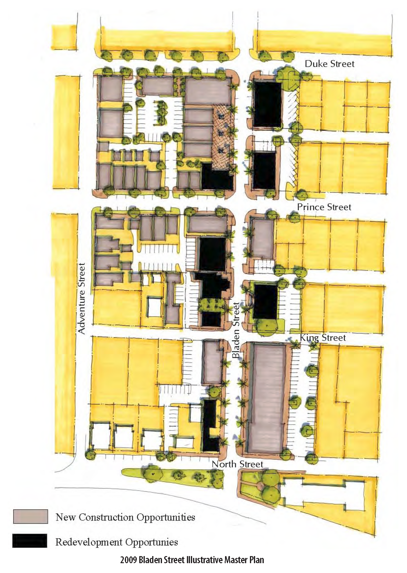
The Bladen Street master plan was created during a community design charrette that took place in 2001 and involved input from major stakeholders, consultants, city staff, and the general public. A $1.2 million public investment into streetscape improvements was completed in 2013. The plan synthesizes community ideas and depicts the idealized build-out for the Bladen Street Redevelopment District. The Bladen Street master plan identifies key opportunity parcels for potential development, redevelopment, parking locations, and preservation.
B.3.1 - HISTORY AND PURPOSE
In September 2005, the city created a master plan for the Boundary Street Redevelopment District through a design charrette process involving the community and a team of design professionals. These regulations are form-based and reflect the existing character of Beaufort and the surrounding region. The code enables a mixed-use physical environment to further enhance the economic and cultural success of Boundary Street and contiguous areas. Traditional urban design conventions have been applied to create a palette of street types that form the framework for the Boundary Street Redevelopment District by setting design parameters for how buildings and other elements relate to those streets. These street standards are found in Appendix C. Applications for development in the Boundary Street Redevelopment District do not have to comply with the design specifics of the recommended texts as listed in Appendix D.1; the texts are for reference and guidance only and are not to be seen as regulatory. Where approvals, interpretations, and judgments are subject to reasonable application by city officials, these officials shall use the applicable sections for guidance as to best practices.
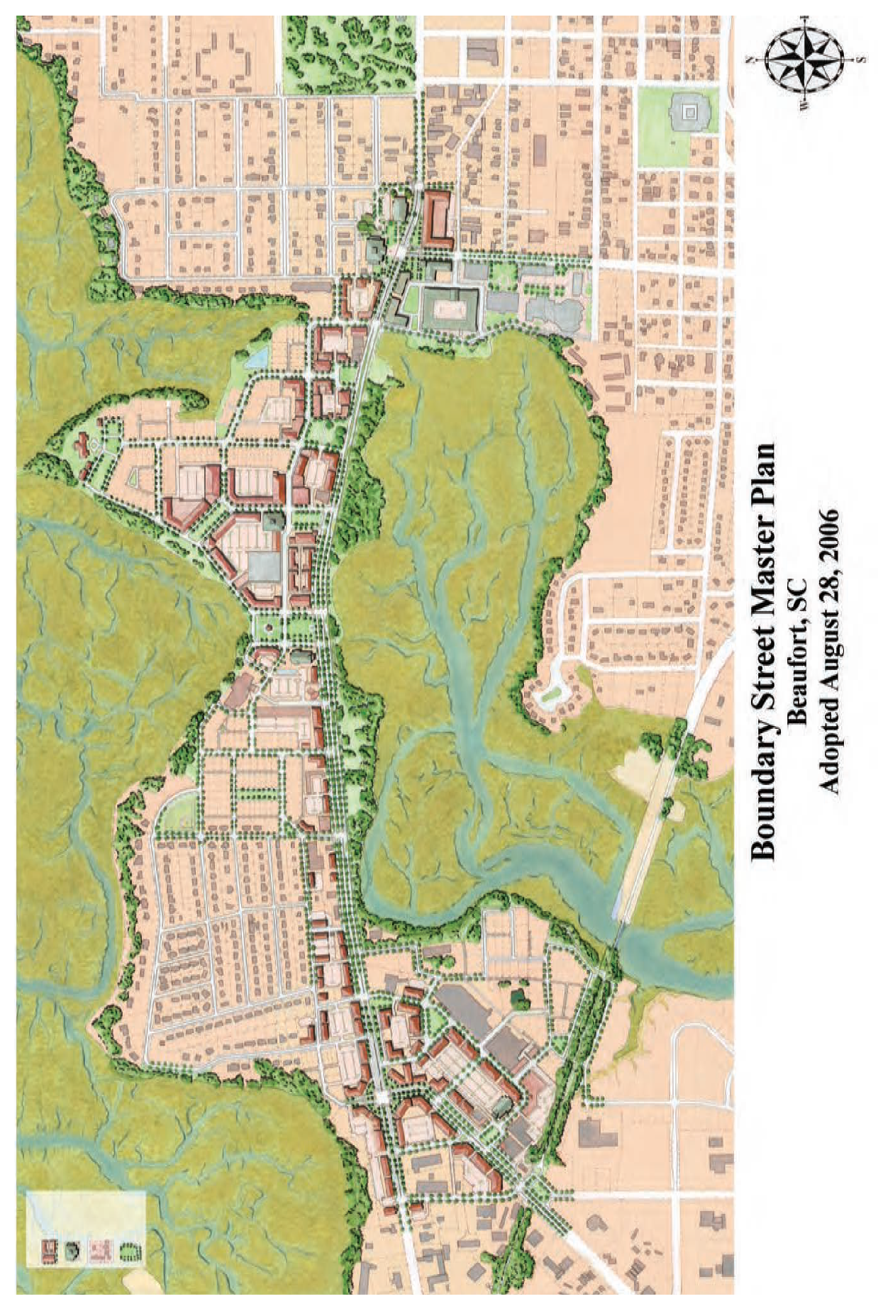
B.3.2 - MASTER PLAN
The Boundary Street master plan was created during a community design charrette which took place September 23-29, 2005 and involved input from major stakeholders, consultants, city staff, and the general public. The plan synthesizes community ideas and depicts the idealized build-out for the Boundary Street Redevelopment District. The Boundary Street master plan identifies key opportunity parcels for potential development, redevelopment, parking locations, and preservation. A large version of the Boundary Street master plan is available at the Department of Planning and Development Services. The illustrative master plan in this section, and the Street Sections in Appendix C, shall serve as guidance to the city architect with respect to the city's intent for land development in the Boundary Street Redevelopment District. The illustrative master plan is meant to demonstrate the character intended for the Redevelopment District, but is for illustrative purposes only. The accompanying text and numbers are rules that govern permitted development.