
Beaufort City Zoning Code
APPENDIX C
STREET INFRASTRUCTURE PLANS
C.1: - GENERAL
The primary goal of the Street Infrastructure Plans is to create a connected street network which offers safe and convenient access for all users (pedestrians, bicyclists, drivers and transit riders) of all ages and abilities.
The following pages outline street standards that promote a complete street system by tailoring street design to its intended users and development context. This is done via the following diagrams:
C.5: - STREET SECTIONS
| C.5.1 | Major Thoroughfare (MT: 78 ft +) | 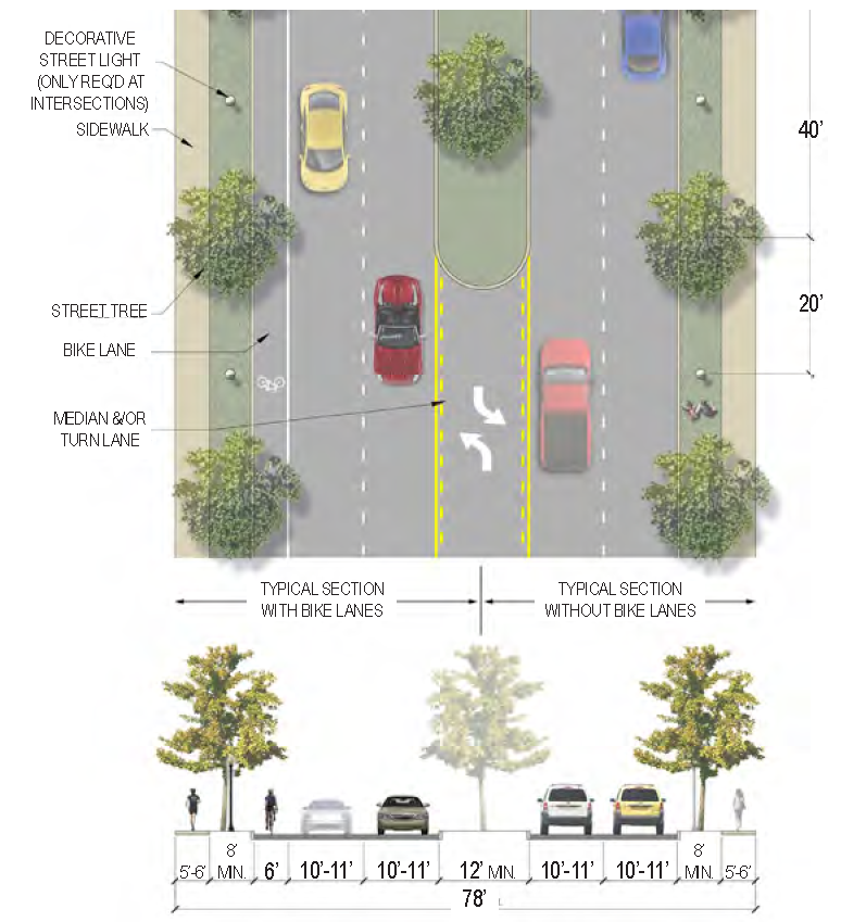 |
| Description | The primary purpose of this street type is to facilitate the movement of cars between regional destinations. As such, the application of this street type is limited to a few major corridors in the rural areas of Beaufort. | |
| Curb Type | Curb or open swale | |
| Right-of-Way Width | 78 feet minimum | |
|
Traffic Lanes
(Pavement Width) | 4 lanes (10 to 11 feet each) & Center turn lane and/or median (12 feet min.) | |
|
Movement
(Design Speed) | Limited Access (45 MPH) | |
|
Parking Lanes
(Width) | N/A | |
| Bike Facilities | Bike lanes (6 feet each) as needed | |
| Sidewalk (Width) | 2 sides (5 to 6 feet each) | |
| Planter Type (Width) | Planting strip (8 feet minimum) & Planted median (12 feet minimum) | |
| Street Trees | 40 feet on-center average | |
|
Specific
Applicability | See Street Regulating Plan | |
| C.5.2 | Boulevard (BV: 54 ft—74 ft) | 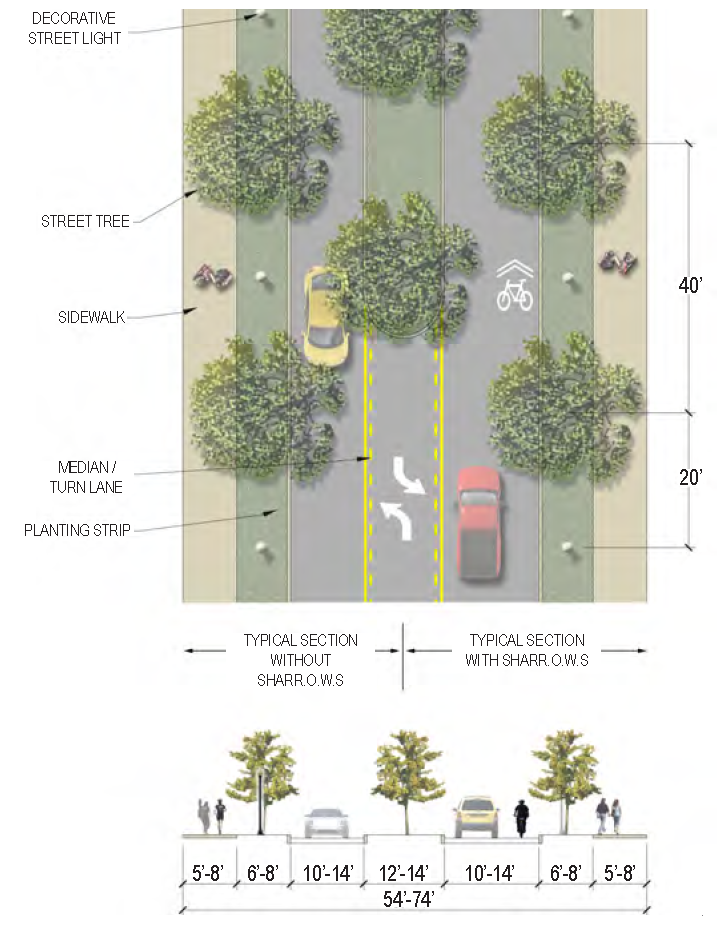 |
| Description | This street type is most commonly applied to neighborhood connectors where on-street parking is not necessary and at entrances to residential neighborhoods. It can be adapted to both urban and suburban conditions depending on the access needs of fronting properties. This street type is also appropriate for use in industrial areas and is applied throughout the Commerce Park area of Beaufort. | |
| Curb Type | Curb | |
| Right-of-Way Width | 54 to 74 feet | |
|
Traffic Lanes
(Pavement Width) | 2 lanes (10 feet each OR 14 feet each w/sharrows) | |
|
Movement
(Design Speed) | Moderate (30 MPH) | |
|
Parking Lanes
(Width) | N/A | |
| Bike Facilities |
Sharrows as needed
(14 feet shared lanes) | |
| Sidewalk (Width) | 2 sides (5 to 8 feet each) | |
| Planter Type (Width) | Planting strip (6 to 8 feet) & Planted median (12 to 14 feet) | |
| Street Trees | 40 feet on-center average in planting strips and median | |
|
Specific
Applicability | For Hermitage Road, the only proposed improvements are the installation of sharrow markings. For other usage of this section, please refer to the Street Regulating Plan. | |
| C.5.3 | Main Street 1—Primary (MS1: 60 ft—76 ft) | 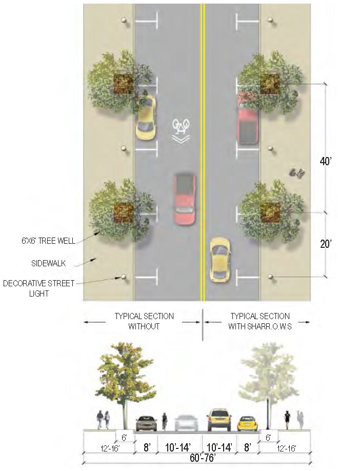 |
| Description | This street type is intended to serve Beaufort's Main Street corridors. These streets are designed to accommodate the highest density of residential and commercial use and the greatest concentration of pedestrian activity. | |
| Curb Type | Curb | |
| Right-of-Way Width | 60 to 76 feet | |
|
Traffic Lanes
(Pavement Width) | 2 lanes (10 feet each OR 14 feet each w/sharrows) | |
|
Movement
(Design Speed) | Slow (25 MPH) | |
|
Parking Lanes
(Width) | 2 sides parallel parking (8 feet each); angled parking may be permitted if sufficient R.O.W. exists | |
| Bike Facilities |
Sharrows as needed
(14 feet shared lanes) | |
| Sidewalk (Width) | 2 sides (12 to 16 feet each)* | |
| Planter Type (Width) | Tree wells (6 feet by 6 feet)* | |
| Street Trees | 40 feet on-center max., overstory; 24 feet on-center max., understory or palms | |
|
Specific
Applicability | See Street Regulating Plan | |
| * In the Historic District the sidewalks should be as wide as possible within the existing right-of-way. In some instances, 5- to 10-foot sidewalks may be the maximum possible within the existing right-of-way. Where the maximum possible sidewalk width is 10 feet or less, street trees in tree wells should not be required. | ||
| C.5.4 | Main Street 2—Limited (MS2: 50 ft—68 ft) | 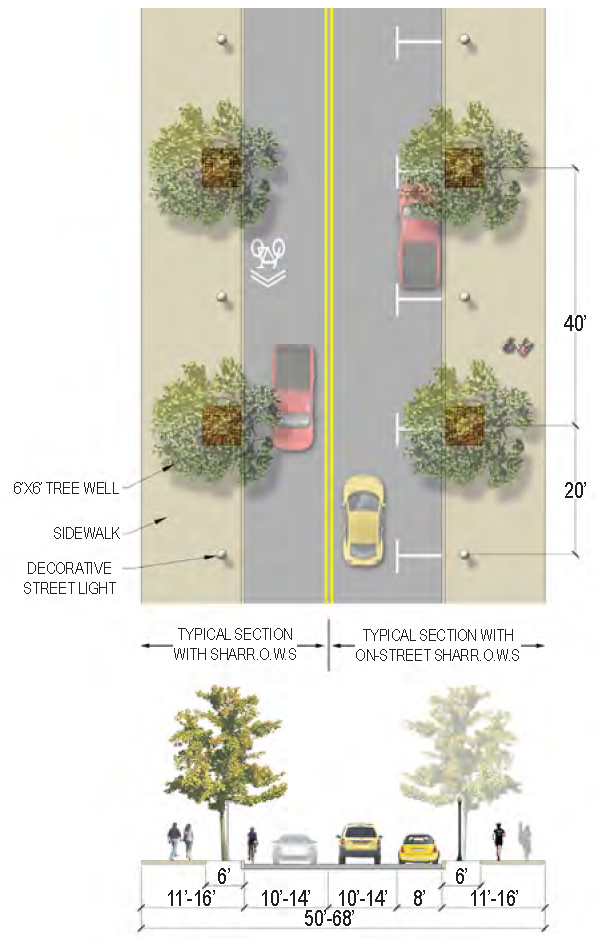 |
| Description | This street type is designed for situations where adjacent development calls for a commercial street typology, but the right-of-way is not wide enough to accommodate a Type I Main Street. This street type is also appropriate for the blocks between residential neighborhoods and mixed-use corridors/districts, as they can quickly transition to another street type within the span of a block or less. | |
| Curb Type | Curb | |
| Right-of-Way Width | 50 to 68 feet | |
|
Traffic Lanes
(Pavement Width) | 2 lanes (10 feet each OR 14 feet each w/sharrows) | |
|
Movement
(Design Speed) | Slow (25 MPH) | |
|
Parking Lanes
(Width) | 1 side parallel parking (8 feet); angled parking may be permitted if sufficient R.O.W. exists | |
| Bike Facilities |
Sharrows as needed
(14 feet shared lanes) | |
| Sidewalk (Width) | 2 sides (12 to 16 feet each)* | |
| Planter Type (Width) | Tree wells (6 feet by 6 feet)* | |
| Street Trees | 40 feet on-center max., overstory; 24 feet on-center max., understory or palms | |
|
Specific
Applicability | See Street Regulating Plan | |
| * In the historic district the sidewalks should be as wide as possible within the existing right-of-way. In some instances, 5- to 10-foot sidewalks may be the maximum possible within the existing right-of-way. Where the maximum possible sidewalk width is 10 feet or less, street trees in tree wells should not be required. | ||
| C.5.5 | Avenue (AV: 54 ft—74 ft) | 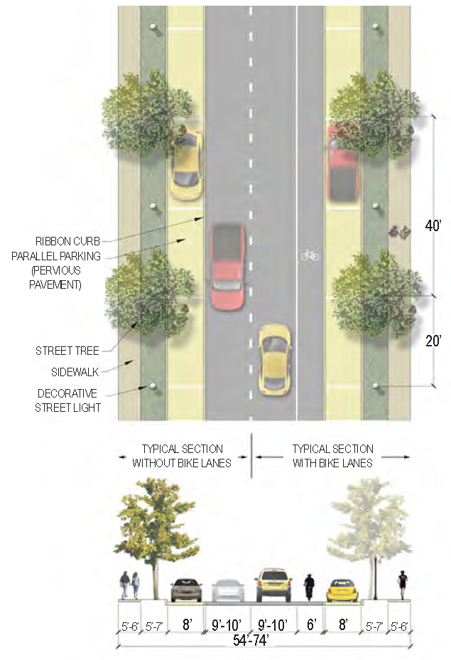 |
| Description | Appropriate in both residential and commercial contexts, avenues serve as a primary connectors between residential and mixed-use areas, often terminating at prominent buildings or plazas. The on-street parking they provide helps to support activity in neighborhood and employment centers. | |
| Curb Type | Curb | |
| Right-of-Way Width | 54 to 74 feet | |
|
Traffic Lanes
(Pavement Width) | 2 lanes (9 to 10 feet each) | |
|
Movement
(Design Speed) | Slow (25 MPH) | |
|
Parking Lanes
(Width) | 2 sides parallel parking (8 feet each) - Pervious pavement preferred; angled parking may be permitted if sufficient R.O.W. exists | |
| Bike Facilities | Bike lanes (6 feet each) as needed | |
| Sidewalk (Width) | 2 sides (5 to 6 feet each) | |
| Planter Type (Width) | Planting strip (5 to 7 feet) | |
| Street Trees | 40 feet on-center max., overstory; 24 feet on-center max., understory or palms | |
|
Specific
Applicability | See Street Regulating Plan | |
| C.5.6 | Parkway (PW: 52 ft—68ft) | 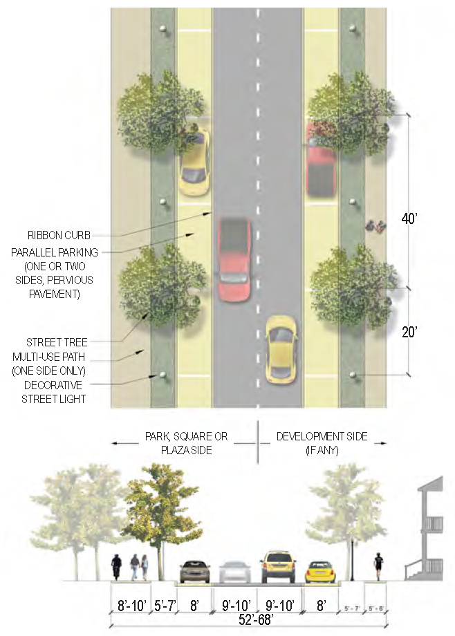 |
| Description | Parkways are intended to be fronted on at least one side by a park, square, plaza, river or marsh. If such park/natural spaces front only one side of the street. Parkways are suitable to support a broad range of development types on the opposite side, including residential, commercial, mixed-use and civic buildings. Parkways accommodate pedestrians and bicyclists through a multi-use path located on any one side of the street which is fronted by a park/natural space. Where right-of-way is sufficient, Parkways provide parallel parking on both sides of the street. If the right-of-way is constrained, parallel parking is required on one side of the street only, preferably on the side of the street with fronting development. A sidewalk/multi-use path may not be required on the park side. | |
| Curb Type | Curb | |
| Right-of-Way Width | 52 to 68 feet | |
|
Traffic Lanes
(Pavement Width) | 2 lanes (9 to 10 feet each) | |
|
Movement
(Design Speed) | Slow (25 MPH) | |
|
Parking Lanes
(Width) | 2 sides parallel parking (8 feet each) where R.O.W is sufficient, OR 1 side parallel parking (8 feet, preferably on development side). Pervious pavement preferred for all parallel parking; angled parking may be permitted if sufficient R.O.W. exists. | |
| Bike Facilities | Multi-use path | |
| Sidewalk (Width) | 1 side (5 to 8 feet, or 8 to 10 feet multi-use path) | |
| Planter Type (Width) | Planting strip (5 to 7 feet each) | |
| Street Trees | 40 feet on-center max., overstory; 24 feet on-center max., understory or palms | |
|
Specific
Applicability | See Street Regulating Plan | |
| C.5.7 | Neighborhood St. 1—General (NS1: 50 ft—62 ft) | 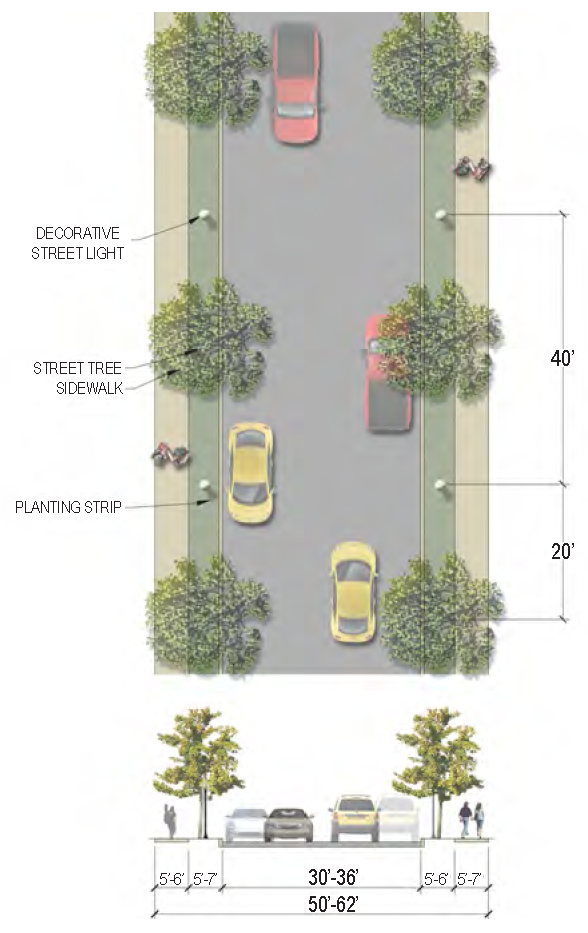 |
| Description | Type 1 Neighborhood Streets are the most common urban street type in Beaufort. These versatile streets are typically unmarked in residential neighborhoods to allow for informal parking, but can be striped with bike lanes and/or a lane of on-street parking as necessary in more urban situations. As Beaufort's neighborhoods begin to fill in and intensify over time, this street type with its formal curbs and sidewalks may be applied as the logical next step in urbanization from Low Impact Development roads with their open swale drainage. | |
| Curb Type | Curb | |
| Right-of-Way Width | 50 to 62 feet | |
|
Traffic Lanes
(Pavement Width) | 2 lanes (30 to 36 feet total) - Marked or Unmarked | |
|
Movement
(Design Speed) | Slow (25 MPH) | |
|
Parking Lanes
(Width) | Informal - 1 side only if bike lane is included; angled parking may be permitted if sufficient R.O.W exists | |
| Bike Facilities | Signed route or bike lane (5 feet) as needed | |
| Sidewalk (Width) | 2 sides (5 to 6 feet each) | |
| Planter Type (Width) | Planting strip (5 to 7 feet) | |
| Street Trees | 40 feet on-center max., overstory; 24 feet on-center max., understory or palms | |
|
Specific
Applicability | See Street Regulating Plan | |
| C.5.8 | Neighborhood St. 2—Yield (NS2: 40 ft—50 ft) | 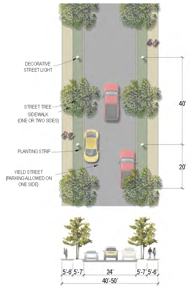 |
| Description | Type 2 Neighborhood Streets are primarily intended to serve single-family structures in residential neighborhoods. The traveled way for cars is slightly narrower than a Type 1 Neighborhood Street, calming traffic and allowing for a yield flow of cars between vehicles parked on the street. | |
| Curb Type | None | |
| Right-of-Way Width | 40 to 50 feet | |
|
Traffic Lanes
(Pavement Width) | 2 lanes (24 feet total) - Unmarked | |
|
Movement
(Design Speed) | Yield Flow (25 MPH) | |
|
Parking Lanes
(Width) | Informal - parking allowed on one side | |
| Bike Facilities | Signed route as needed | |
| Sidewalk (Width) | 1 or 2 sides (5 to 6 feet each)* | |
| Planter Type (Width) | Planting strip (5 to 7 feet) | |
| Street Trees | 40 feet on-center typical but can vary to accommodate existing trees where possible | |
|
Specific
Applicability | See Street Regulating Plan | |
| * In the Historic District sidewalks should only be constructed as needed. | ||
| C.5.9 | Neighborhood St. 3—Lane (NS3: 38 ft—46 ft) | 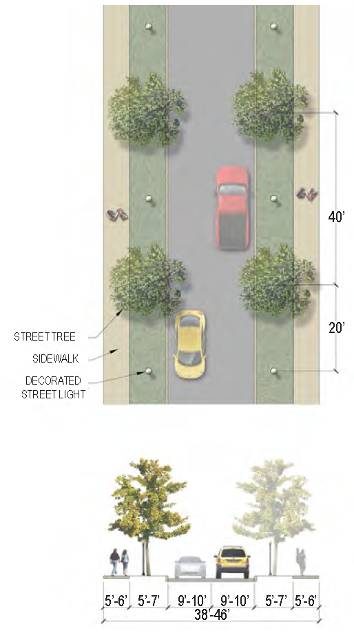 |
| Description | Type 3 Neighborhood Streets are small residential lanes intended to provide direct access to the front of a limited number of single-family structures. This street type should be used in situations where the right-of-way is too constrained for other typical street types, and is ideally paired with a Rear Lane that provides off-street parking access to the rear of lots. | |
| Curb Type | Curb | |
| Right-of-Way Width | 38 to 46 feet | |
|
Traffic Lanes
(Pavement Width) | 2 lanes (9 to 10 feet each) - Unmarked | |
|
Movement
(Design Speed) | Slow (25 MPH) | |
|
Parking Lanes
(Width) | N/A | |
| Bike Facilities | Signed route as needed | |
| Sidewalk (Width) | 1 or 2 sides (5 to 6 feet each) | |
| Planter Type (Width) | Planting strip (5 to 7 feet) - May be waived if R.O.W. is not sufficient | |
| Street Trees | 40 feet on-center max., overstory; 24 feet on-center max., understory or palms | |
|
Specific
Applicability | See Street Regulating Plan | |
| C.5.10 | Low Impact Development Rd. (LID: 38 ft +) | 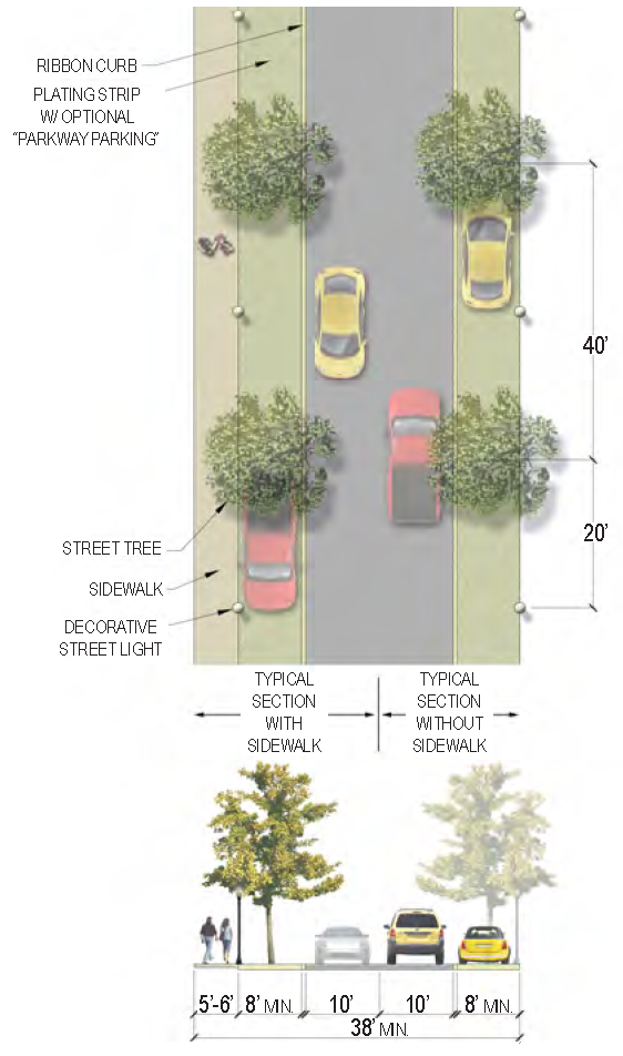 |
| > Description | In areas where a formal curb and sidewalk treatment is not needed to support adjacent development, this street type provides adequate infrastructure while allowing for the passive infiltration of stormwater at the street edge. In addition to providing drainage, the planting strip area may be reinforced to allow for on-street "parkway parking" between required street trees. Sidewalks should be provided as necessary where the right-of-way is wide enough to accommodate them. | |
| Curb Type | None Required | |
| Right-of-Way Width | 38 feet minimum* | |
|
Traffic Lanes
(Pavement Width) | 2 lanes (10 feet each) | |
|
Movement
(Design Speed) | Slow (25 MPH) | |
|
Parking Lanes
(Width) | Optional "parkway parking" w/in planting strip area (8 feet each side) | |
| Bike Facilities | Signed route as needed | |
| Sidewalk (Width) | Optional (5 to 6 feet each) | |
| Planter Type (Width) | Planting strip (8 feet minimum - may be used for "parkway parking")* | |
| Street Trees | 40 feet on-center max., overstory; 24 feet on-center max., understory or palms | |
|
Specific
Applicability | See Street Regulating Plan | |
| * In the Historic District the minimum permitted right-of-way width should be decreased as necessary, by eliminating a planting strip from one side of the street, to accommodate existing corridors that are particularly narrow. (Example: King Street) | ||
| C.5.11 | Rural Road (RR: 45 ft +) | 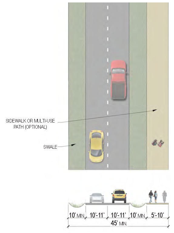 |
| Description | This street type is widely applied throughout Beaufort's rural areas in instances where adjacent development does not require the support of substantial infrastructure. As such, the Rural Roads street type includes only limited pedestrian accommodation and open swale drainage. | |
| Curb Type | Open swale or Curb | |
| Right-of-Way Width | 45 feet minimum | |
|
Traffic Lanes
(Pavement Width) | 2 lanes (10 to 11 feet each) - May include center turn lane | |
|
Movement
(Design Speed) | Moderate (35 MPH) | |
|
Parking Lanes
(Width) | N/A | |
| Bike Facilities | Multi-use path - Optional | |
| Sidewalk (Width) | 1 side (5 feet or 10 feet with multi-use path) | |
| Planter Type (Width) | Planting strip (10 feet minimum) | |
| Street Trees | N/A | |
|
Specific
Applicability | See Street Regulating Plan | |
| C.5.12 | Commercial Alley (CA: 24 ft) | 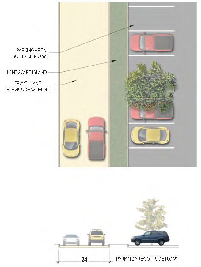 |
| Description | This street type is intended to be privately maintained and is used most frequently as an access lane for off-street parking and loading areas. Although primary building entrances should always be located along the major fronting street and any large off-street parking areas, in certain situations adjacent structures may include secondary/service entrances that allow direct access from rear commercial alleys. | |
| Curb Type | None | |
| Right-of-Way Width | 24 feet | |
|
Traffic Lanes
(Pavement Width) | 2 lanes (24 feet) - Pervious pavement preferred | |
|
Movement
(Design Speed) | Slow (25 MPH) | |
|
Parking Lanes
(Width) | N/A | |
| Bike Facilities | N/A | |
| Sidewalk (Width) | N/A | |
| Planter Type (Width) | Parking area landscape islands (varied width) | |
| Street Trees | Located within parking area landscape islands | |
|
Specific
Applicability | See Street Regulating Plan | |
| C.5.13 | Rear Lane (RL: 16 ft) | 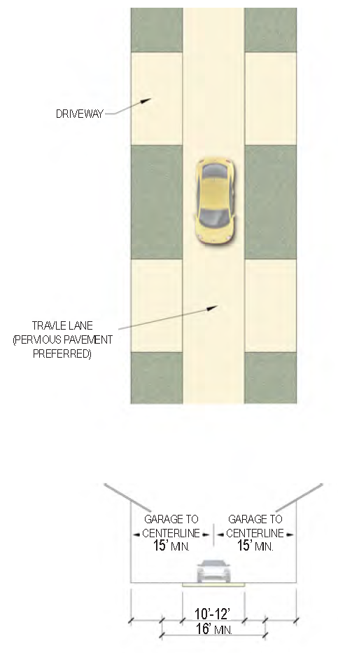 |
| Description | This street type is intended to be privately maintained and provide indirect, limited access to the rear of residential properties. It is not intended to accommodate through traffic but may accommodate city services such as garbage and recycling collection. Utilities, either above ground or underground, may be located in Rear Lanes to provide service connections to adjacent properties. | |
| Curb Type | None | |
| Right-of-Way Width | 20 feet minimum | |
|
Traffic Lanes
(Pavement Width) | 1 lane (10 to 12 feet) - Pervious Pavement Preferred | |
|
Movement
(Design Speed) | Slow (25 MPH) | |
|
Parking Lanes
(Width) | N/A | |
| Bike Facilities | N/A | |
| Sidewalk (Width) | N/A | |
| Planter Type (Width) | N/A | |
| Street Trees | N/A | |
|
Specific
Applicability | See Street Regulating Plan | |
C.6: - SPECIFIC STREET SECTIONS
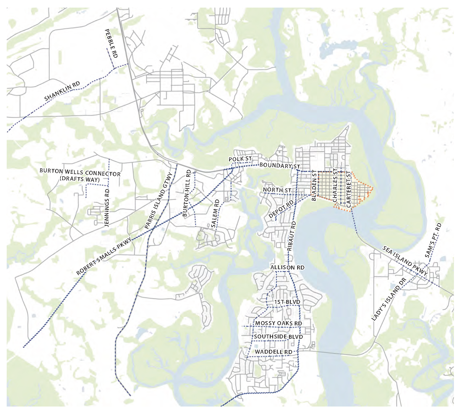
Street Regulating Plan—Other Streets with Specific Street Sections. All of the street segments marked as "Other" in the Street Regulating Plan (illustrated in the map above) have been assigned one of the specific street sections on the following pages. These street sections were carefully designed during the Civic Master Plan process to address unique site-specific considerations. As such, these street sections are specifically tailored to a unique development context and deviate from the standards enumerated in the typical street sections. In some cases, a specific street section may apply only to a portion of a single street. In other cases, a specific street section may apply to multiple streets. The applicability of each specific street section is enumerated in its corresponding table.
| C.6.1 | Allison Rd. (ST: 47-49 ft) | 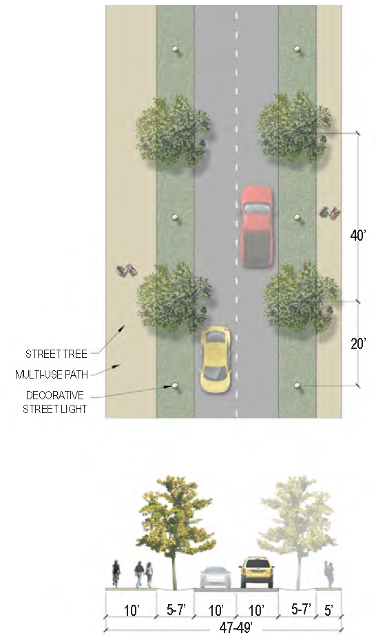 |
|
Specific
Applicability | • Allison Road - entire length | |
| Curb Type | Curb | |
| Right-of-Way Width | 47—49 feet | |
|
Traffic Lanes
(Pavement Width) | 2 lanes (10 feet each) | |
|
Movement
(Design Speed) | Slow (25 MPH) | |
|
Parking Lanes
(Width) | N/A | |
| Bike Facilities | Multi-use path primarily on south side | |
| Sidewalk (Width) | 2 sides (5 feet on north side, 10 feet multi-use path primarily on south side) | |
| Planter Type (Width) | Planting strip (5—7 feet) | |
| Street Trees | 40 feet on-center max., overstory; 24 feet on-center max., understory or palms | |
| Phasing | Phase 1: South side of travel-way Phase 2: North side of travel-way | |
| C.6.2 | Battery Creek Rd. A (RD: 50 ft) | 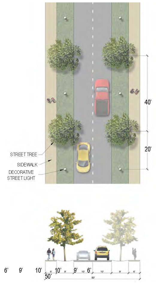 |
|
Specific
Applicability | • Battery Creek Road from Allison Road to First Boulevard | |
| Curb Type | Open swale | |
| Right-of-Way Width | 50 feet | |
|
Traffic Lanes
(Pavement Width) | 2 lanes (10 feet each) | |
|
Movement
(Design Speed) | Slow (25 MPH) | |
|
Parking Lanes
(Width) | N/A | |
| Bike Facilities | N/A | |
| Sidewalk (Width) | 2 sides (6 feet each) | |
| Planter Type (Width) | Planting strip (9 feet) | |
| Street Trees | 40 feet on-center average, opportunistic | |
| C.6.3 | Battery Creek Rd. B (RD: 56 ft) | 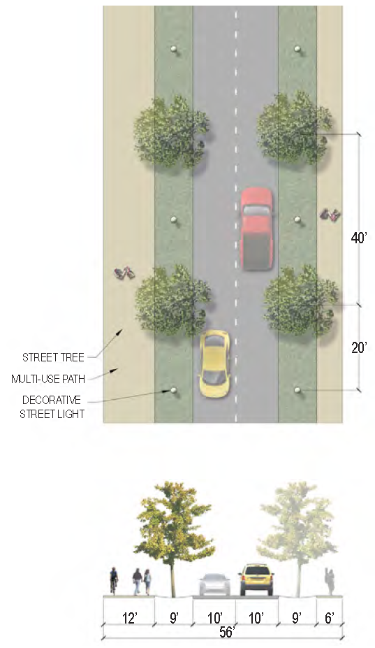 |
|
Specific
Applicability | • Battery Creek Road from First Boulevard to Waddell Road | |
| Curb Type | Curb | |
| Right-of-Way Width | 56 feet | |
|
Traffic Lanes
(Pavement Width) | 2 lanes (10 feet each) | |
|
Movement
(Design Speed) | Slow (25 MPH) | |
|
Parking Lanes
(Width) | N/A | |
| Bike Facilities | Multi-use path, West side only | |
| Sidewalk (Width) | 2 sides (6 feet on East side, 12 feet multi-use path on West side) | |
| Planter Type (Width) | Planting strip (9 feet) | |
| Street Trees | 40 feet on-center average | |
| C.6.4 | Bladen St. & Charles St. B (ST: 55 ft) | 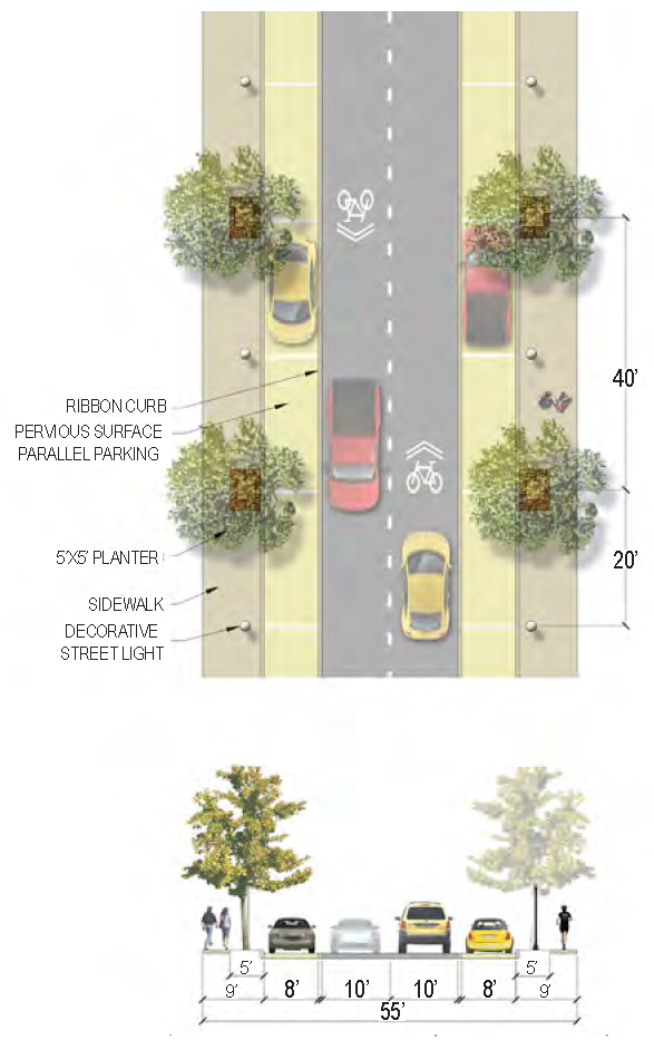 |
|
Specific
Applicability |
• Bladen Street - entire length
• Charles Street from Duke Street to Calhoun Street | |
| Curb Type | Curb | |
| Right-of-Way Width | 55 feet | |
|
Traffic Lanes
(Pavement Width) | 2 lanes (10 feet each) | |
|
Movement
(Design Speed) | Slow (25 MPH) | |
|
Parking Lanes
(Width) | 2 sides parallel parking (8 feet each) - Pervious pavement | |
| Bike Facilities | Sharrows | |
| Sidewalk (Width) | 2 sides (9 feet each) | |
| Planter Type (Width) | Planters (5 feet by 5 feet) | |
| Street Trees | 40 feet on-center max., overstory; 24 feet on-center max., understory or palms | |
| C.6.5 | Boundary St. 1 - West of Ribaut Rd. (BLVD: 90 ft—130 ft) | 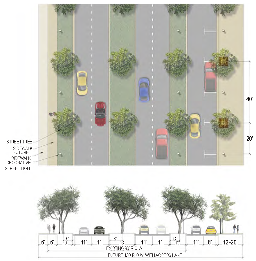 |
|
Specific
Applicability | Boundary Street Context Zone 1 (West of Ribaut Road) | |
| Curb Type | Curb | |
| Right-of-Way Width | 90 feet for current improvements, 130 feet for future improvements | |
|
Traffic Lanes
(Pavement Width) | 4 lanes (11 feet each) and 1 future access lane (11 feet) | |
|
Movement
(Design Speed) | Moderate (35 MPH) | |
|
Parking Lanes
(Width) | 1 side future parallel parking (8 feet) | |
| Bike Facilities | N/A | |
| Sidewalk (Width) | 1 side (6 feet) for current improvements 2 sides (12 to 20 feet) for future improvements | |
| Planter Type (Width) | Planting strip (10 feet) & Planted median (16 feet) | |
| Street Trees | 40 feet on-center average | |
| C.6.6 | Boundary St. 2A— East of Ribaut Road (ST: 60 ft) | 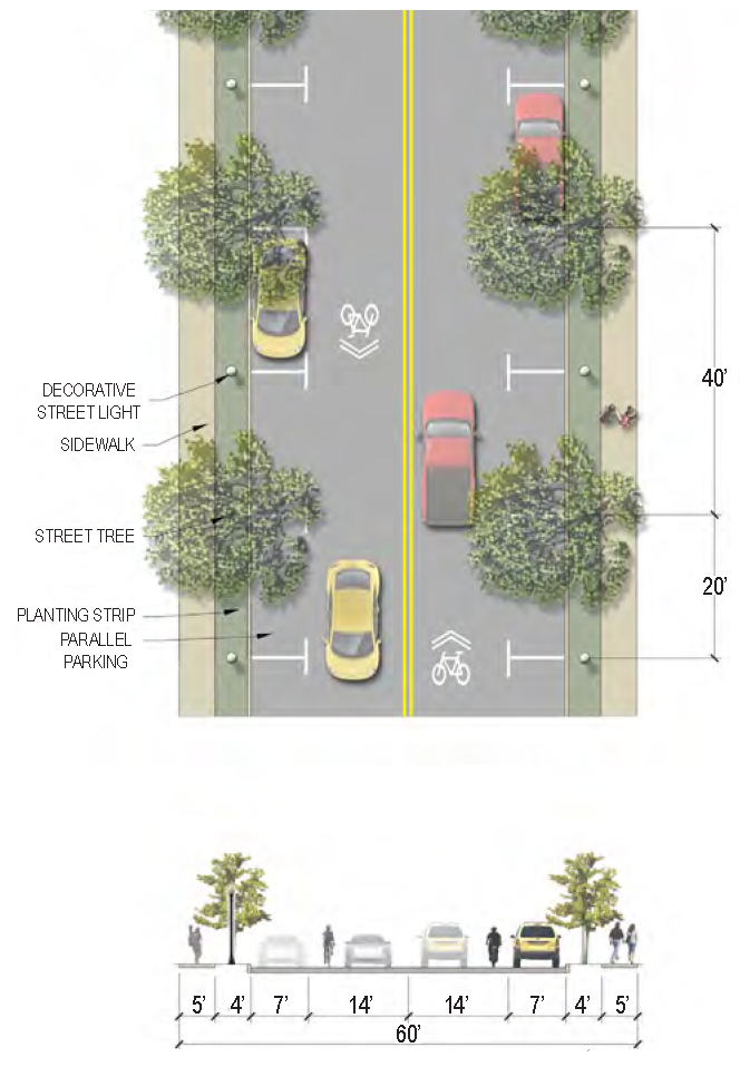 |
|
Specific
Applicability | • Boundary Street (from Ribaut Road east to Carteret Street) - intended to be applied as a preliminary Phase 1 condition in the redevelopment of the Boundary Street corridor. The final phase condition is illustrated in "Boundary St. A2" below. | |
| Curb Type | Curb | |
| Right-of-Way Width | 60 feet | |
|
Traffic Lanes
(Pavement Width) | 2 lanes (14 feet each) | |
|
Movement
(Design Speed) | Slow (25 MPH) | |
|
Parking Lanes
(Width) | 2 sides parallel parking (7 feet each) | |
| Bike Facilities | Sharrows (14 feet shared lanes) | |
| Sidewalk (Width) | 2 sides (5 feet each) | |
| Planter Type (Width) | Planting strip (4 feet) | |
| Street Trees | 40 feet on-center max., overstory; 24 feet on-center max., understory or palms | |
| C.6.7 | Boundary St. 2B— East of Ribaut Road (ST: 66 ft—76 ft) | 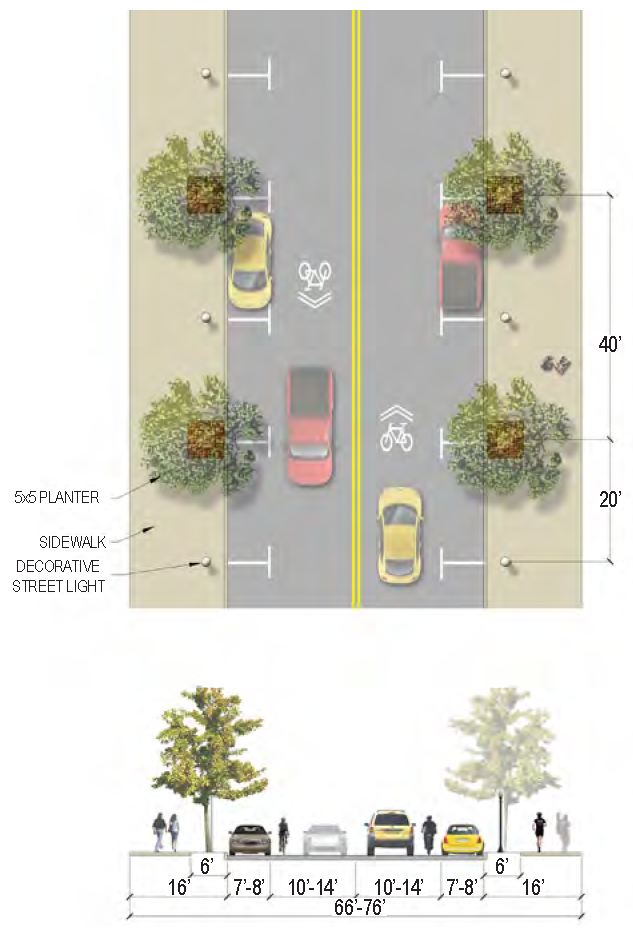 |
|
Specific
Applicability | • Boundary Street (from Ribaut Road to Carteret Street) - intended to be applied as a final Phase 2 condition in the redevelopment of the Boundary Street corridor. The preliminary phase condition is illustrated in "Boundary St. 2A" above. | |
| Curb Type | Curb | |
| Right-of-Way Width | 66 to 76 feet | |
|
Traffic Lanes
(Pavement Width) | 2 lanes (10 to 14 feet each) | |
|
Movement
(Design Speed) | Slow (25 MPH) | |
|
Parking Lanes
(Width) | 2 sides parallel parking (7 to 8 feet each) | |
| Bike Facilities | Sharrows (10 to 14 feet shared lanes) | |
| Sidewalk (Width) | 2 sides (16 feet each) | |
| Planter Type (Width) | Tree wells (5 feet by 5 feet) | |
| Street Trees | 40 feet on-center max., overstory; 24 feet on-center max., understory or palms | |
| C.6.8 | Burton Hill Rd. (BLVD: 100 ft) | 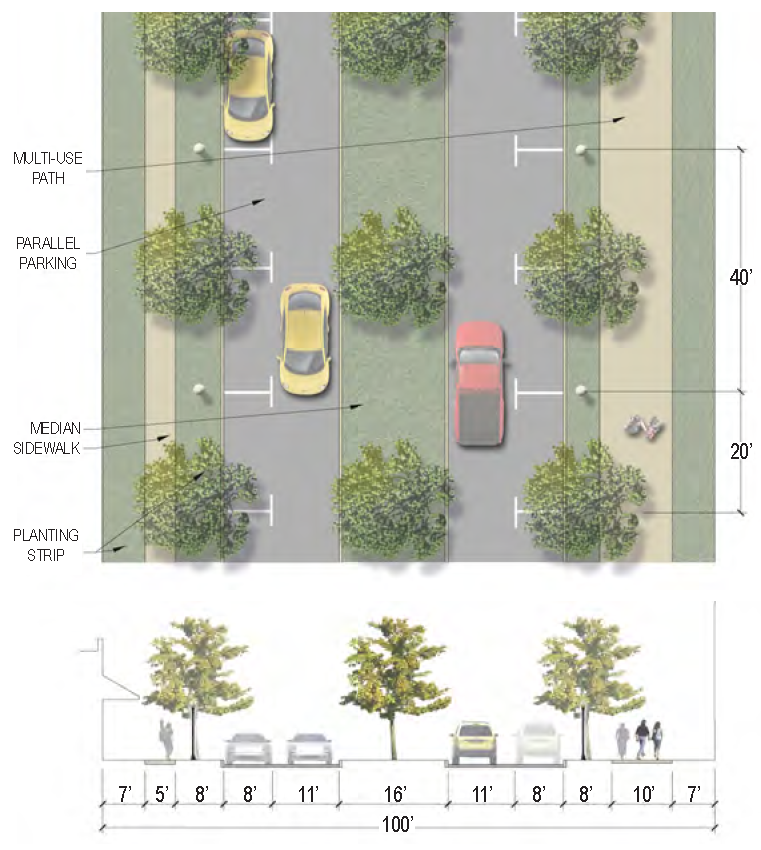 |
|
Specific
Applicability | • Burton Hill Road - entire length. This ambitious street section was designed due to the purpose this road serves. It links residential neighborhoods to higher intensity commercial and industrial development. A private developer will be required to install the entire street section only if developing a whole block - bound by perpendicular streets on both the north and south edge of the development - along Burton Hill Road. If developing less than one block, the only portion required to be installed, per table 7.1.3, are the portions of the street section behind the curb, on whichever side of the road the development is located on. | |
| Curb Type | Curb | |
| Right-of-Way Width | 100 feet | |
|
Traffic Lanes
(Pavement Width) | 2 lanes (11 feet each) | |
|
Movement
(Design Speed) | Slow (25 MPH) | |
|
Parking Lanes
(Width) | 2 sides parallel parking (8 feet) | |
| Bike Facilities | Multi-use path (one side only) | |
| Sidewalk (Width) | Sidewalk on west side (5 feet), Multi-use path on east side (10 feet) | |
| Planter Type (Width) | Planting strip (8 feet) & Planted median (16 feet) | |
| Street Trees | 40 feet on-center average | |
| C.6.9 | Burton Wells Connector (BLVD: 75 ft +) | 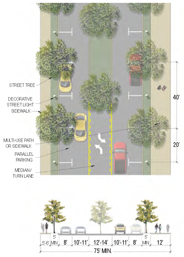 |
|
Specific
Applicability | • Future Burton Wells connector from Burton Wells Park (extending from Burton Wells Drive) to Boundary Street | |
| Curb Type | Curb | |
| Right-of-Way Width | 75 feet minimum | |
|
Traffic Lanes
(Pavement Width) | 2 lanes (10 to 11 feet each) | |
|
Movement
(Design Speed) | Slow (25 MPH) | |
|
Parking Lanes
(Width) | 2 sides parallel parking (8 feet) | |
| Bike Facilities | Multi-use path | |
| Sidewalk (Width) | Sidewalk on south side (5 to 6 feet), Multi-use path on north side (12 feet) | |
| Planter Type (Width) | Planting strip (5 feet minimum) & Planted median (12 to 14 feet) | |
| Street Trees | 40 feet on-center average | |
| C.6.10 | Charles St. A (ST: 45 ft) | 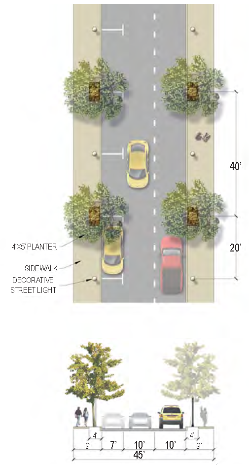 |
|
Specific
Applicability | • Charles Street from Bay Street to Duke Street (See also: Bladen St./Charles St. B) | |
| Curb Type | None | |
| Right-of-Way Width | 45 feet | |
|
Traffic Lanes
(Pavement Width) | 2 lanes (10 feet each) | |
|
Movement
(Design Speed) | Slow (25 MPH) | |
|
Parking Lanes
(Width) | 1 side parallel parking (8 feet) | |
| Bike Facilities | N/A | |
| Sidewalk (Width) | 2 sides (9 feet each) | |
| Planter Type (Width) | Planters (4 feet by 5 feet) | |
| Street Trees | 40 feet on-center average | |
| C.6.11 | Deanne Dr. A (ST: 36 ft—46 ft) | 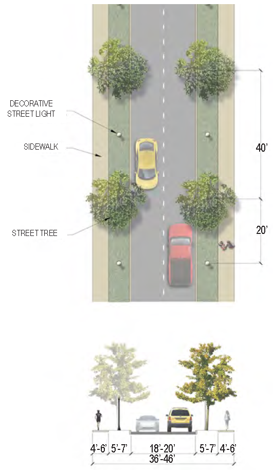 |
|
Specific
Applicability | • Deanne Drive - existing street & future connection to Beaufort Plaza across the Spanish Moss Trail | |
| Curb Type | Curb | |
| Right-of-Way Width | 36 to 46 feet | |
|
Traffic Lanes
(Pavement Width) | 2 lanes (9 to 10 feet each) | |
|
Movement
(Design Speed) | Slow (25 MPH) | |
|
Parking Lanes
(Width) | N/A | |
| Bike Facilities | N/A | |
| Sidewalk (Width) | 2 sides (4 to 6 feet each) | |
| Planter Type (Width) | Planting strip (5 to 7 feet) | |
| Street Trees | 40 feet on-center average | |
| C.6.12 | Deanne Dr. B (ST: 50 ft) | 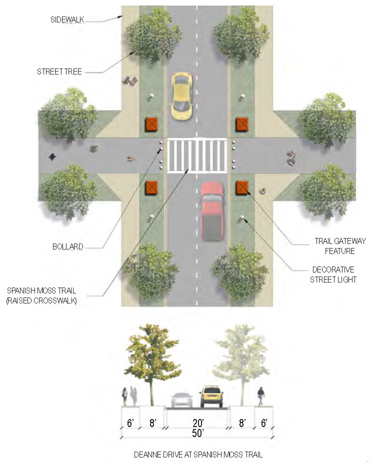 |
|
Specific
Applicability | • Deanne Drive - at future intersection with Spanish Moss Trail | |
| Curb Type | Curb | |
| Right-of-Way Width | 50 feet | |
|
Traffic Lanes
(Pavement Width) | 2 lanes (10 feet each) | |
|
Movement
(Design Speed) | Slow (25 MPH) | |
|
Parking Lanes
(Width) | N/A | |
| Bike Facilities | N/A | |
| Sidewalk (Width) | 2 sides (6 feet each) | |
| Planter Type (Width) | Planting strip (8 feet) | |
| Street Trees | 40 feet on-center average | |
| C.6.13 | Depot Rd. B (ST: 60 ft) | 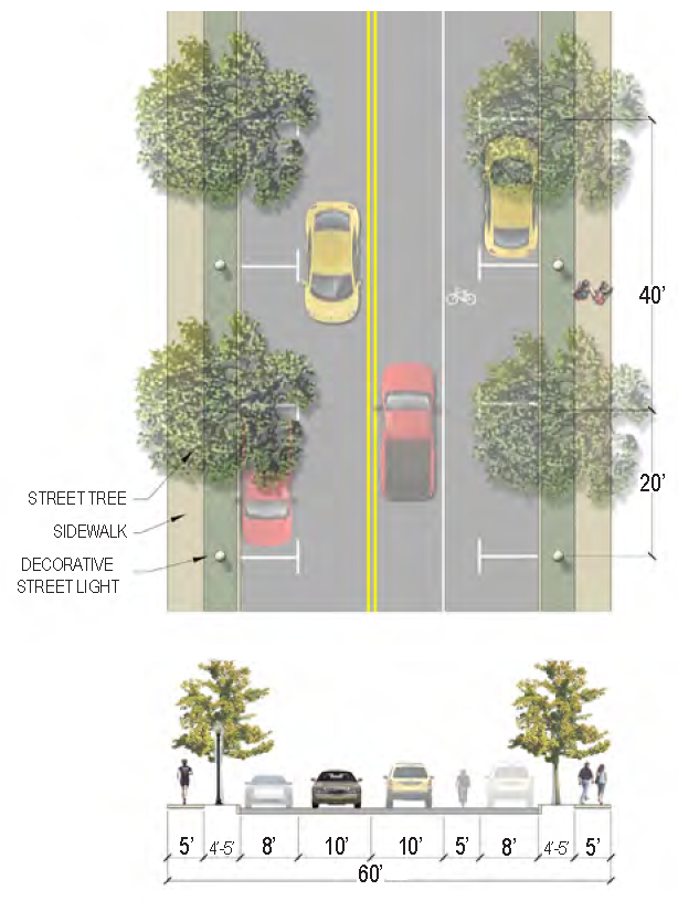 |
|
Specific
Applicability | • Depot Road from Burroughs Avenue to Depot Road redevelopment area (See also: North St./Depot Rd. A) | |
| Curb Type | Curb | |
| Right-of-Way Width | 60 feet | |
|
Traffic Lanes
(Pavement Width) | 2 lanes (10 feet each) | |
|
Movement
(Design Speed) | Slow (25 MPH) | |
|
Parking Lanes
(Width) | 2 sides parallel parking (8 feet each) | |
| Bike Facilities | 1 side (5 feet) - South side | |
| Sidewalk (Width) | 2 sides (5 feet each) | |
| Planter Type (Width) | Planting strip (4 to 5 feet) | |
| Street Trees | 40 feet on-center average | |
| C.6.14 | Depot Rd. C (ST: 90 ft—150 ft) | 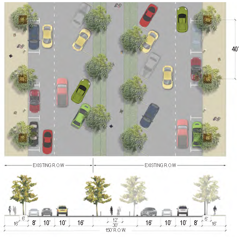 |
|
Specific
Applicability | • Depot Road redevelopment area (Hay Street to Middleton Street) - intended to be built in phases begininning with the existing 90-foot right-of-way and eventually replicating on the west side of the Spanish Moss Trail within an expanded 150-foot right-of-way (See also: North St./Depot Rd. A). | |
| Curb Type | Normal curb on development side, flush curb on trail side* | |
| Right-of-Way Width | 90 feet, expanding to 150 feet | |
|
Traffic Lanes
(Pavement Width) | 2 lanes, expanding to 4 lanes (10 feet each) | |
|
Movement
(Design Speed) | Slow (25 MPH) | |
|
Parking Lanes
(Width) | Parallel parking (7 feet) on development side, 30 degree diagonal parking (16 feet) on trail side | |
| Bike Facilities | Spanish Moss Trail | |
| Sidewalk (Width) | Development side (16 feet each), Spanish Moss Trail (12 feet) | |
| Planter Type (Width) | Tree wells (6 feet by 6 feet) | |
| Street Trees | 40 feet on-center average | |
| C.6.15 | First St. A (ST: 40 ft) | 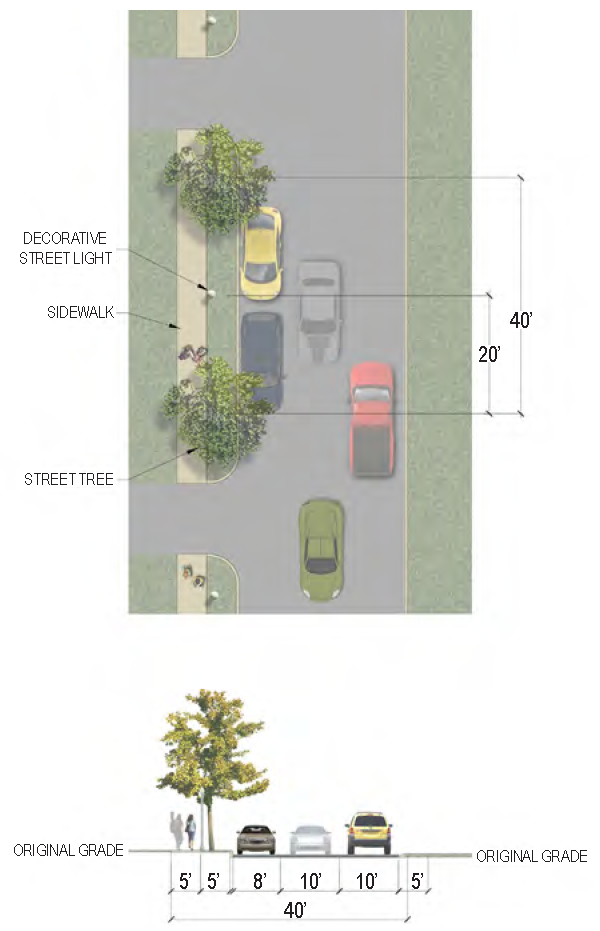 |
|
Specific
Applicability | • First Street from Westview Avenue to Hogarth Street | |
| Curb Type | Normal curb on North side, Roll curb on South side | |
| Right-of-Way Width | 40 feet | |
|
Traffic Lanes
(Pavement Width) | 2 lanes (10 feet each) | |
|
Movement
(Design Speed) | Slow (25 MPH) | |
|
Parking Lanes
(Width) | North side only parallel parking (8 feet) | |
| Bike Facilities | N/A | |
| Sidewalk (Width) | North side only (5 feet) | |
| Planter Type (Width) | Planting strip (5 feet) | |
| Street Trees | North side only, 40 feet on-center average | |
| C.6.16 | First St. B (ST: 50 ft) | 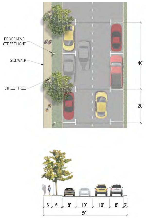 |
|
Specific
Applicability | • First Street future extension from Boundary Street to Westview Avenue | |
| Curb Type | Curb | |
| Right-of-Way Width | 50 feet | |
|
Traffic Lanes
(Pavement Width) | 2 lanes (10 feet each) | |
|
Movement
(Design Speed) | Slow (25 MPH) | |
|
Parking Lanes
(Width) | 2 sides parallel parking (8 feet each) | |
| Bike Facilities | N/A | |
| Sidewalk (Width) | North side only (5 feet) | |
| Planter Type (Width) | Planting strip (6 feet on North side, 2 feet on South side) | |
| Street Trees | North side only, 40 feet on-center average | |
| C.6.17 | Jennings Rd. B (ST: 56 ft) | 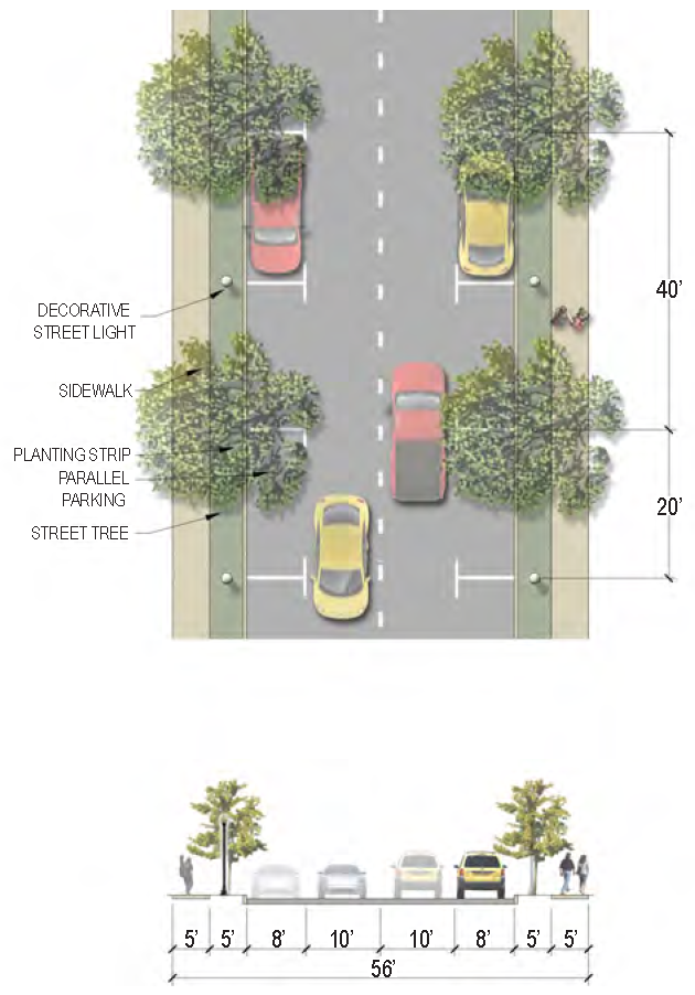 |
|
Specific
Applicability | • Jennings Road - intended to be used in the proposed Jennings Road neighborhood center near Battery Creek High School | |
| Curb Type | Curb | |
| Right-of-Way Width | 56 feet | |
|
Traffic Lanes
(Pavement Width) | 2 lanes (10 feet each) | |
|
Movement
(Design Speed) | Slow (25 MPH) | |
|
Parking Lanes
(Width) | 2 sides parallel parking (8 feet each) | |
| Bike Facilities | N/A | |
| Sidewalk (Width) | 2 sides (5 feet each) | |
| Planter Type (Width) | Planting strip (5 feet) | |
| Street Trees | 40 feet on-center average | |
| C.6.18 | Mossy Oaks Rd. (BLVD: 66 ft—78 ft) | 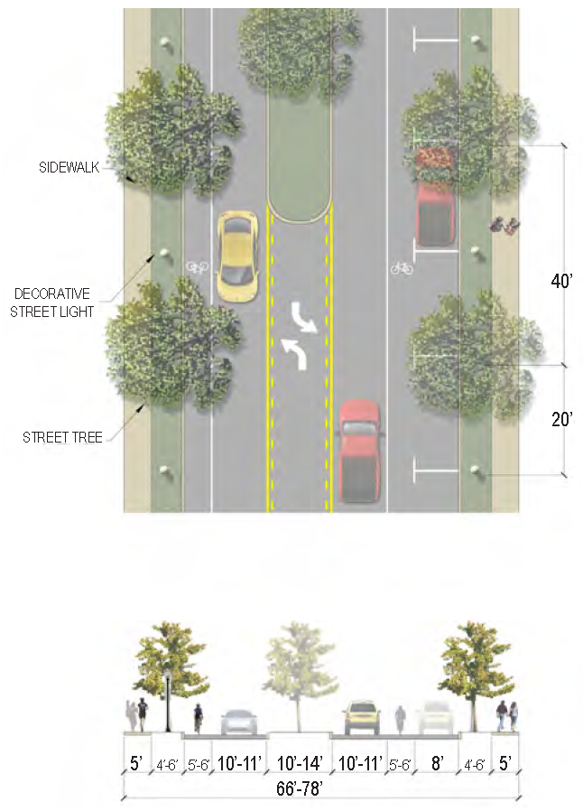 |
|
Specific
Applicability | • Mossy Oaks Road from Ribaut Road to Battery Creek Road | |
| Curb Type | Curb | |
| Right-of-Way Width | 66 to 78 feet | |
|
Traffic Lanes
(Pavement Width) | 2 lanes (10 to 11 feet each) | |
|
Movement
(Design Speed) | Slow (25 MPH) | |
|
Parking Lanes
(Width) | 1 sides parallel parking (8 feet) | |
| Bike Facilities | Bike lanes | |
| Sidewalk (Width) | 2 sides (5 feet each) | |
| Planter Type (Width) | Planting strip (4 to 6 feet) | |
| Street Trees | 40 feet on-center average | |
| C.6.19 | North St. & Depot Rd. A (ST: 44 ft—46 ft) | 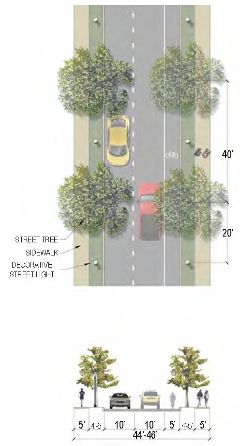 |
|
Specific
Applicability |
• North Street - entire length
• Depot Street from Ribaut Road to Burroughs Avenue | |
| Curb Type | Curb | |
| Right-of-Way Width | 44 to 46 feet | |
|
Traffic Lanes
(Pavement Width) | 2 lanes (10 feet each) | |
|
Movement
(Design Speed) | Slow (25 MPH) | |
|
Parking Lanes
(Width) | N/A | |
| Bike Facilities | 1 side (5 feet) - South side of Depot Rd. and North side of North St. | |
| Sidewalk (Width) | 2 sides (5 feet each) | |
| Planter Type (Width) | Planting strip (4 to 5 feet) | |
| Street Trees | 40 feet on-center average | |
| C.6.20 | Polk St. Extension (a.k.a. First Street) (ST: 40 ft) | 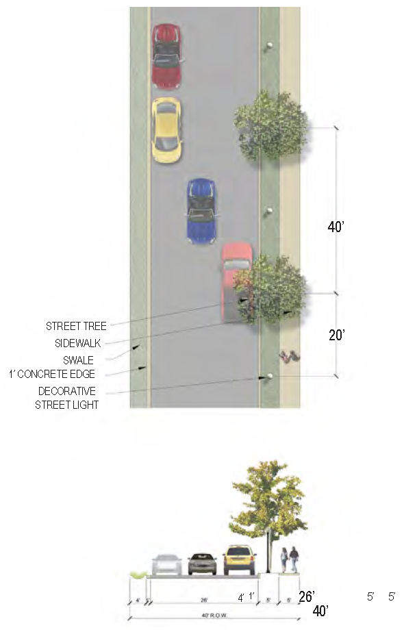 |
|
Specific
Applicability | • Polk Street Extension connecting to Robert Smalls Parkway across Boundary Street | |
| Curb Type | Curb/1' Concrete edge with small swale | |
| Right-of-Way Width | 40 feet; when wider, a planted median is used | |
|
Traffic Lanes
(Pavement Width) | 2 lanes (9 feet each) | |
|
Movement
(Design Speed) | Slow (25 MPH) | |
|
Parking Lanes
(Width) | 1 side parallel parking (8 feet) | |
| Bike Facilities | N/A | |
| Sidewalk (Width) | 1 sides (5 feet) | |
| Planter Type (Width) | Planting Strip (5 feet) | |
| Street Trees | 40 feet on-center average | |
| C.6.21 | Port Republic St. (ST: 45 ft) | 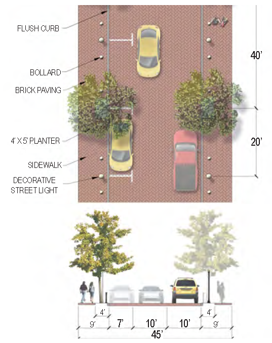 |
|
Specific
Applicability | • Port Republic Street from Charles Street to Carteret Street; this street section is for City streetscape purposes and is not required to be installed, per table 7.3.1, by any private development unless a developer chooses to do so. | |
| Curb Type | Flush curb | |
| Right-of-Way Width | 45 feet | |
|
Traffic Lanes
(Pavement Width) | 2 lanes (10 feet each) - brick pavers | |
|
Movement
(Design Speed) | Slow (25 MPH) | |
|
Parking Lanes
(Width) | 1 side parallel parking (7 feet) | |
| Bike Facilities | N/A | |
| Sidewalk (Width) | 2 sides (9 feet each) - brick pavers | |
| Planter Type (Width) | Tree wells (4 feet by 5 feet) | |
| Street Trees | 40 feet on-center average | |
| C.6.26 | Robert Smalls Pkwy. (BLVD: 84 ft +) | 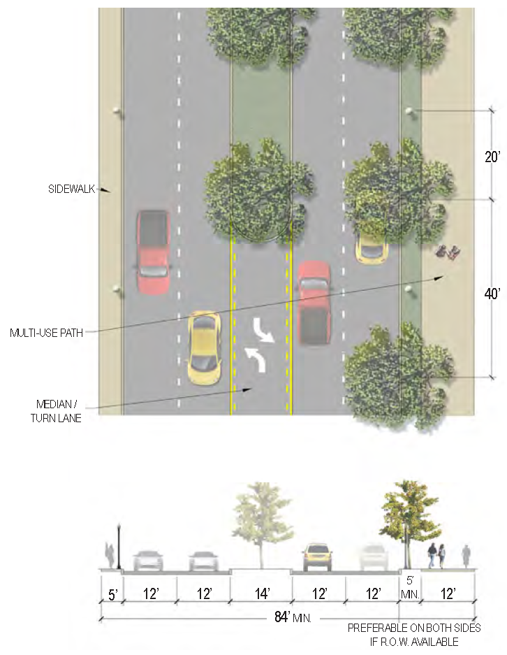 |
|
Specific
Applicability | • Robert Smalls Parkway - entire length | |
| Curb Type | Curb | |
| Right-of-Way Width | 84 feet minimum | |
|
Traffic Lanes
(Pavement Width) | 4 lanes (12 feet each) | |
|
Movement
(Design Speed) | Limited Access (45 MPH) | |
|
Parking Lanes
(Width) | N/A | |
| Bike Facilities | Multi-use path | |
| Sidewalk (Width) | 2 sides (5 feet and 12 feet multi-use path) | |
| Planter Type (Width) | Planting strip (5 feet minimum) & Planted median (14 feet) | |
| Street Trees | 40 feet on-center average | |
| C.6.27 | Sams Point Rd. (BLVD: 100 ft) |  |
|
Specific
Applicability | • Sams Point Road from Sea Island Parkway to Miller Drive | |
| Curb Type | Curb | |
| Right-of-Way Width | 100 feet | |
|
Traffic Lanes
(Pavement Width) | 4 lanes (12 feet each) | |
|
Movement
(Design Speed) | Moderate (35 MPH) | |
|
Parking Lanes
(Width) | N/A | |
| Bike Facilities | Raised cycle track (6 feet each) | |
| Sidewalk (Width) | 2 sides (13 feet each) | |
| Planter Type (Width) | Tree wells (6 feet by 6 feet) & Planted median (14 feet) | |
| Street Trees | 40 feet on-center average | |
| C.6.28 | Sea Island Pkwy. & Lady's Island Dr. (BLVD: 100 ft) |  |
|
Specific
Applicability |
• Sea Island Parkway from Youmans Drive to Cougar Drive
• Lady's Island Drive from Sea Island Parkway to Rue Du Bois | |
| Curb Type | Curb | |
| Right-of-Way Width | 100 feet | |
|
Traffic Lanes
(Pavement Width) | 4 lanes (12 feet each) | |
|
Movement
(Design Speed) | Moderate (35 MPH) | |
|
Parking Lanes
(Width) | N/A | |
| Bike Facilities | Raised cycle track (6.5 feet width each) | |
| Sidewalk (Width) | 2 sides (16 feet each) | |
| Planter Type (Width) | Tree wells (6 feet by 6 feet) | |
| Street Trees | 40 feet on-center average | |
| C.6.29 | Shanklin Rd. & Salem Rd. (RD: 60 ft) |  |
|
Specific
Applicability |
• Shanklin Road - entire length
• Salem Road - intended to be used along undevelopable land South of Moss Street | |
| Curb Type | Open swale | |
| Right-of-Way Width | 60 feet | |
|
Traffic Lanes
(Pavement Width) | 2 lanes (10 feet each) | |
|
Movement
(Design Speed) | Moderate (35 MPH) | |
|
Parking Lanes
(Width) | N/A | |
| Bike Facilities | Multi-use path, East side only | |
| Sidewalk (Width) | 1 side (10 feet multi-use path on East side) | |
| Planter Type (Width) | Planting strip (varied width) | |
| Street Trees | N/A | |
| C.6.30 | Southside Blvd. & First Blvd. (ST: 66 ft—70 ft) |  |
|
Specific
Applicability |
• Southside Boulevard - entire length
• First Boulevard - entire length | |
| Curb Type | Open swale | |
| Right-of-Way Width | 66 to 70 feet | |
|
Traffic Lanes
(Pavement Width) | 2 lanes (9 to 10 feet each) | |
|
Movement
(Design Speed) | Moderate (35 MPH) | |
|
Parking Lanes
(Width) | N/A | |
| Bike Facilities | N/A | |
| Sidewalk (Width) | 2 sides (5 feet each) | |
| Planter Type (Width) | Planting strip (varied width) | |
| Street Trees | 40 feet on-center average | |
| C.6.31 | Waddell Rd. & Jennings Rd. A (RD: 60 ft—68 ft) | 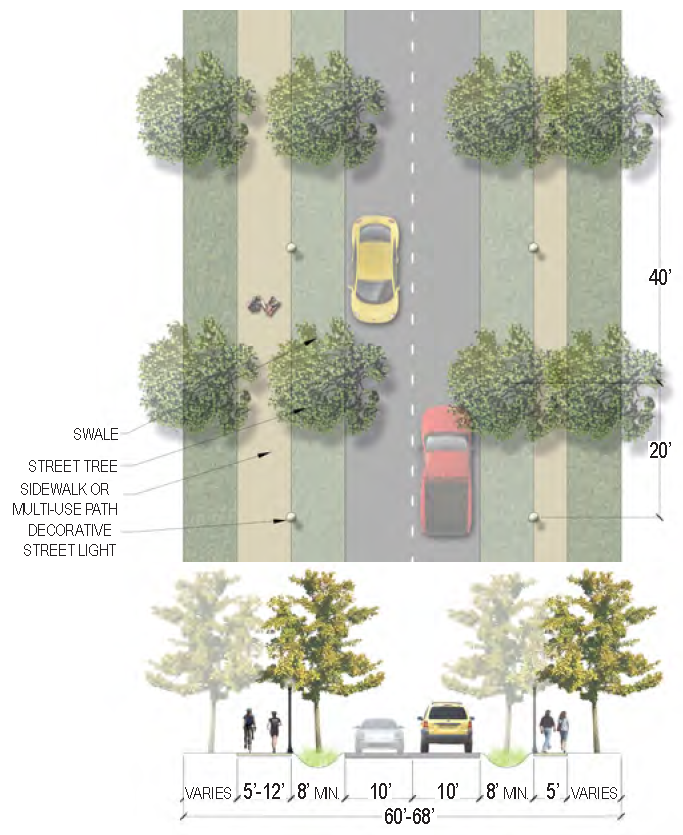 |
|
Specific
Applicability |
• Waddell Road - entire length
• Jennings Road - intended to be used along the portions of Jennings Road NOT located in the Jennings Road neighborhood center near Battery Creek High School | |
| Curb Type | Open swale | |
| Right-of-Way Width | 60 to 68 feet | |
|
Traffic Lanes
(Pavement Width) | 2 lanes (10 feet each) | |
|
Movement
(Design Speed) | Moderate (35 MPH) | |
|
Parking Lanes
(Width) | N/A | |
| Bike Facilities | Multi-use path, North side of Waddell Road only | |
| Sidewalk (Width) | 2 sides (5 feet and 12 feet multi-use path on Waddell Road, 5 feet each on Jennings Road) | |
| Planter Type (Width) | Planting strip (8 feet minimum) | |
| Street Trees | N/A | |
C.1.1 - OFFICIAL STREET NETWORK PLAN—EXISTING, ADOPTED AND PROPOSED
The Official Street Network Plan, divided into different segments of the city, depicts the existing street network in the city, proposed streets that have been adopted as part of an existing Official Map [hereby referred to as "new adopted streets"], and new streets that are proposed as part of the Civic Master Plan process. New proposed streets that are not part of an existing Official Map, as indicated in blue on the diagrams, are non-binding and for recommendation only. See Section 7.2.1 B. for establishment and implementation details.
C.1.2 - STREET HIERARCHY DIAGRAM
This diagram, showing both existing streets and new adopted streets, indicates the most significant streets and intersections in the city. The code refers to Primary and Secondary streets and Significant Intersections particularly in the District Standards (Article 2), Land Use Provisions (Article 3) and Building Design Standards (Article 4). For further definitions and applicability of Primary Streets, see the definition in Article 13.
C.1.3 - STREET REGULATING PLAN
This diagram, showing both existing streets and new adopted streets, indicates the prescribed street section for each street, based on existing conditions, future development potential and existing right-of-way dimension. New proposed streets that are not part of an existing Official Map are indicated on the second page of the diagrams for each area of the city. These are included as a guide for how development could potentially occur; they are non-binding and for recommendation only. See Section 7.2.1 for information on applicability and implementation.
C.1.4 - TYPICAL STREET SECTIONS
Beaufort has a number of typical street designs that capture the unique vernacular of of the area. The Street Regulating Plan applies specific expectations for streetscape characteristics to every street segment in the city. Each street type identified on the Street Regulating Plan maps corresponds to a street section diagram on the following pages that establishes the specific standards for that street.
C.1.5 - SPECIFIC STREET SECTIONS
In certain instances, portions of streets have been marked as "Other" on the Street Regulating Plan diagrams. These street segments have been specifically designed with details that deviate from the typical street sections to respond to the context: specific environmental, neighborhood, or development opportunities. Each of these specific street sections are included in this chapter following the typical street sections that apply to most streets throughout Beaufort.
In some cases, a specific street section may apply only to a portion of a single street. In other cases, a specific street section may apply to multiple streets. The applicability of each specific street section is detailed in a corresponding table.
A.
Military Roads: Some streets have been identified as "Military Roads" in the Street Infrastructure Plan. These streets have been left to the discretion of their associated military authority.
B.
Overhead Utilities: It is the intention of this plan to continue the city's pursuit of the burying of overhead utilities as a part of each street improvement project where funding permits. Where lines cannot be buried, the city will continue to work with the utility providers to replace or eliminate dead lines, unused equipment, and aging poles to improve the overall aesthetics of the entire city.
C.1.6 - TREE PLANTING STANDARDS
The following standards shall be used in conjunction with the appropriate street section.
A.
Minimum Quantities: Street trees shall be installed according to the the street sections in C.4 and C.5.
B.
Minimum Spacing: Arrangement of and distance between hardwood trees should correspond to the expected mature spread of the trees and shall in no instance be less than:
1.
Forty feet between overstory trees.
2.
Twenty-five feet between overstory trees and understory trees.
3.
Fifteen feet between understory trees and palms.
C.
Conflict with Street Lighting: Street trees shall be located and planted so as not to diminish the effectiveness of required street lighting, and in no instance shall street lights be located closer than:
1.
Fifteen feet to overstory trees.
2.
Eight feet to understory trees.
D.
Tree Wells:
1.
In commercial areas where there is no planting strip, trees shall be provided with grates, hard surface tree wells, or other approved methods of root protection.
2.
Tree wells for overstory trees shall be as specified per street section. The ideal tree well size is 5 feet by 10 feet; however tree wells may be reduced to 5 feet by 5 feet if structural soils or silva cells are provided. Root barrier fabric is required.
3.
Tree wells for understory or palm trees shall be a minimum of 5 feet by 5 feet.