
Beaufort City Zoning Code
5
LANDSCAPING, PARKING AND LIGHTING This content was modified in this version of the code. modified
5.4: - PERIMETER BUFFERS, LANDSCAPING AND SCREENING
Perimeter buffers are intended to provide spatial separation between uses of differing intensities. Buffers that are required for protection of environmentally sensitive areas are prescribed by Section 8 (Environmental and Resource Protection).
5.8: - FENCING
The purpose and intent of this section is to establish minimum standards to regulate the location, height, and appearance of fences and walls to maintain visual harmony within neighborhoods and zoning districts throughout the City, protect adjacent properties from the indiscriminate placement and unsightliness of fences and walls, and ensure the safety, security, and privacy of properties.
(Ord. No. 2025/18, Exh. A, 8-19-2025)
5.1.1 - PURPOSE AND INTENT
The purpose and intent of this Code chapter is to regulate and protect a sustainable and healthy tree canopy throughout the City of Beaufort while promoting the benefits and advantages of retaining mature trees in our landscapes, parks, and streets. There are many benefits directly attributable to trees, and the regulation of tree preservation is necessary for the preservation of public health, safety, general welfare, environment and aesthetics in the City of Beaufort. Great care should be taken to integrate new development into the existing landscape, and to preserve natural vegetation where possible.
Specifically, the standards in this section are meant to:
•
Maintain the current and increase for future, the total tree canopy within the City limits;
•
Preserve healthy trees that might otherwise be removed through the required use of arborist reports and tree risk assessments;
•
Lessen air pollution and promote clean air quality by increasing dust filtration;
•
Prevent soil erosion;
•
Improve surface drainage, minimize flooding, and minimize the cost of constructing and maintaining drainage systems necessitated by the increased flow and diversion of surface waters;
•
Conserve energy by reducing heating and cooling costs;
•
Reduce noise, heat, dust, and glare;
•
Preserve biodiversity, wildlife habitat, and habitat corridors;
•
Educate the public as to the importance of trees and the inherent risks that they pose and that most tree risks can be mitigated for;
•
Beautify and enhance land and views from the City's entryways, public lands, and streets;
•
Preserve residents' quality of life and the natural heritage of the City; and
•
Maintain the ambience of the City of Beaufort and enhance property values.
(Ord. No. 2025/18, Exh. A, 8-19-2025)
5.1.2 - DEFINITIONS
1.
Arborist Report. A report compiled by an ISA Certified Arborist containing pertinent information about the physical and structural health of the trees on a site.
2.
Caliper. The diameter of the trunk measured six (6) inches above the ground for trees up to and including four-inch diameter and measured twelve (12) inches above the ground for larger trees. This measurement is used for proposed or nursery-grown trees.
3.
Certified Arborist. A person who has met the criteria for certification from the International Society of Arboriculture (ISA), maintains his or her credentials, and is a employee of the company submitting the request for pruning or removal.
4.
Commercial Use. Any use of property for a principal use of operating a "business," as defined in Section 3.6 and 13.1 of the Beaufort Code, that may be operated for the object of gain or benefit.
5.
Developed Land. Land on which manmade structures exist or land modifications (clearing, grading, etc.) have occurred.
6.
Diameter at Breast Height (DBH). The diameter in inches of the trunk of a tree, or, for multiple trunk trees, the aggregate diameters of multiple trunks, measured four and one-half (4½) feet from the existing grade at the base of the tree. This measurement is used for existing trees.
7.
Diseased tree. A severe disease or pest that is known to cause or is causing the death of a tree.
8.
Drip Line. An imaginary vertical line extending downward from the outermost tips of a tree's branches to the ground.
9.
Hazard. A likely source of harm. In relation to trees, a hazard is the tree part or parts identified as a likely source of harm.
10.
Hazardous tree. A tree is considered hazardous when it has been assessed and found to be likely to fail and cause an unacceptable degree of injury, damage, or disruption - that is, it poses an elevated risk.
11.
Elevated Risk. A tree, or any part of a tree, that poses a risk of harm to person or property due to damage, deterioration, or numerous hazards, and where such risk cannot be mitigated by any arboricultural procedures.
12.
Healthy Tree. A tree that is not dead, dying, or diseased; is not at an elevated risk for failure; or is not an invasive tree.
13.
Impervious Surface. Solid surface that prevents aeration, infiltration, and water penetration, resulting in several harmful side effects.
14.
Invasive Species. Are non-native organisms that are detrimental to our natural areas or native flora and fauna. Managing these pests often costs landowners, land managers, and taxpayers millions of dollars each year. Invasive species contribute to the loss of habitat for native species and contribute to their declines.
15.
Live Crown Ration (LCR). Is the percentage of a tree's total height that supports live foliage, serving as an indicator of tree vigor and health. LCR is calculated by dividing the length of the live crown (the part of the tree with foliage) by the total height of the tree and then multiplying by 100 to express it as a percentage.
16.
Mitigation Pruning. Pruning methods prescribed by a certified arborist that will result in the reduction of the risk of tree or tree limb failure, usually associated with a tree risk assessment report.
17.
Native species. Native species of flora and fauna are organisms that developed naturally in a specific area over time. They evolved alongside other local plants (flora) and animals (fauna), creating balanced relationships within their habitat. Native species form communities and biological interactions with other specific flora, fauna, fungi, and other organisms.
18.
Official. A member of City staff designated by the City Manager.
19.
Overmature Tree. See Senescent Tree.
20.
Overstory Tree. A tree that, when mature, reaches a height of at least thirty-five (35) feet.
21.
Pervious Surface. A surface that allows water to percolate through to the area underneath rather than becoming runoff.
22.
Replacement Planting. Tree planting that is proposed as a replacement for a tree which has been cut down.
23.
Residential Lot of Record. A lot where single, two-, or three-family development is permitted.
24.
Risk. Is the combination of the likelihood of an event and severity of the potential consequences. In the context of trees, risk is the likelihood of a conflict or tree failure occurring and affecting a target and the severity of the associated consequences-personal injury, property damage, or disruption of activities.
25.
Senescent Tree. A tree that has reached a stage where its growth, vigor, and health are declining, often nearing the end of its natural lifespan. It includes both natural age-related decline and stress-induced deterioration. Different tree species react differently to this senescent life stage; some will respond to mitigation pruning.
26.
Specimen and Landmark Trees. see Section 5.3.1.
27.
Tree Protection Zone. The area reserved around a tree or group of trees in which no grading, access, stockpiling, or other construction activity shall occur, the extent of which will be determined by the proposed site design and existing site conditions. See Section 5.3.3 for specific requirements.
28.
Tree Risk Assessment. The systematic process to identify, analyze, and evaluate tree risk, and to recommend mitigation procedures.
29.
Undeveloped Land. Raw land on which manmade structures or land modifications (clearing, grading, etc.) do not exist.
30.
Understory Tree. A tree that, when mature, reaches a height of twelve (12) to thirty-five (35) feet and whose natural habitat is growing under larger, higher canopied trees.
31.
Willful Violation. A violation in which the landowner, developer, and/or operator knowingly failed to comply with the requirements of this section.
(Ord. No. 2025/18, Exh. A, 8-19-2025)
5.1.3 - CERTIFIED ARBORIST REPORT
A.
Requirements: The purpose of a Certified Arborist Report is to perform a visual ground assessment of all trees including Specimen and Landmark trees using the most current copy of certified Tree and Topo created by a Registered Surveyor.
Each tree will have a detailed visual ground inspection of its surrounding site, buttress roots, trunk and branches and an assessment of the tree's general health. The information will be used to determine physical and structural health of the trees, as well as the likelihood of potential failures in each tree. This assessment protocol is based on a modified Level 2, Basic Tree Risk Assessment as outlined in ANSI A300 - Part 9: Tree, Shrub and Other Woody Plant Management - Standard Practices.
The Level 2 Basic Tree Risk Assessment is not the highest level of assessment available to arborists. Any trees that are required to be preserved on site which may need a higher level of assessment shall also be identified and any additional necessary recommendations given.
Recommendations will be given for performance and timing of maintenance procedures, such as crown pruning, root pruning and root fertilization, if deemed needed after soil testing; measures that should be performed on trees that are to be preserved on site.
This report also verifies a positive identification of all trees listed on the Tree and Topo.
B.
Mitigation Pruning: Mitigation pruning is an important component of this report. All of the trees in each of the groupings, except for Category D, will have the potential to improve their standing on the site with the application of mitigation pruning.
This can generally consist of some combination of limb end weight reduction, deadwood and vine removal, the culling of understory plants, or other creative arboricultural methods to reduce some of the risks that trees present and allow more trees to be preserved on site.
C.
Arborist Duty of Care: Arborists have a Duty of Care to the trees that they are assessing, not to the entity who might be financing the report. This Duty of Care takes into consideration hazards that may be found in the trees, potential targets, a tree inherent stability under normal weather conditions, static and dynamic loads and most importantly, what arboricultural procedures can be applied to reduce any of the risks or hazards that may be uncovered. The ultimate site goals and future intentions for these trees by the owner are never a component of the assessment.
D.
Assessment Format: Each of the Specimen and Landmark trees on a site plan will be categorized into four different groups, designating each tree's individual condition based on both structural and physical health factors. In order to make the report more diverse and the tree cover more sustainable, any of the more valuable smaller trees are also suggested to be assessed and highlighted so that there will be more information on their status and thus may be able to remain in the landscape. Each condition grouping will be highlighted with a specific color on the site plan. These designating letters and grouping categories are as follows:
Category A): Highlighted in Green: A tree with no or slight defects and a low risk of failure. This tree is thriving for its species and location. It has little or no obvious faults or defects that would warrant a more detailed inspection. Some minor pruning may be needed including light reduction of end-weight growth and removal of deadwood. Tree longevity is open-ended and unrestricted. There is an improbable likelihood of limb or lead of total trunk failures occurring under normal weather conditions over the next 5 to 10 years. There may be no specific mitigation pruning recommended at this time.
Category B): Highlighted in Orange: A tree with moderate defects having a reasonable risk of failure. This tree is growing well for its species and location. It may have some minor, obvious faults and defects which would need to be aerially inspected. There may be a possible likelihood of limb or lead failures under normal weather conditions over the next 5 to 10 years. There is an improbable likelihood of total trunk failure over the next 5 to 10 years. These possible failures can, in most cases, be mitigated by prescription reduction or heading pruning procedures. These procedures can reduce the risk of failures to a level of risk that can be considered acceptable by most tree managers. There may be some other specific pruning needs such as crown raising, crown reduction, invasive vine severing, deadwood removal and Spanish moss reduction if present in large amounts, over and above the mitigation pruning recommendations.
Category C): Highlighted in Blue: A tree with severe defects and a high risk of failure. This tree is failing to thrive and may be in decline. It has obvious faults, defects, and hazards present that have a probable likelihood of causing limb, lead or trunk failures. Timely prescribed and above normal mitigation pruning may in some cases reduce these hazards and risks of failures to a level that could be acceptable by some tree managers. If mitigation pruning is chosen, monthly inspections by the tree manager and annual inspections by a certified arborist are recommended.
Category D): Highlighted in Red: A tree with critical defects and an imminent risk of failure. This tree may already be dead or, if still alive, has severe critical defects and hazards with an imminent likelihood of limb, lead and total trunk failure. No amount of mitigation pruning could reduce any of the risks present to an acceptable level. Depending on occupancy rates of the areas adjacent to these trees, immediate or timely attention is called for.
E.
Hazard vs. Risk: In the wording of this report, please consider the correct use of the terms hazard and risk in accordance with ANSI A300 Part 9: Tree Shrub, and Other Woody Plant Management - Standard Practices (Tree Risk Assessment and Tree Structure Assessment). A tree is considered hazardous when it has been assessed and found to be likely to fail and cause an unacceptable degree of injury, damage, or disruptions - that is, it poses a high or extreme risk.
Risk is the combination of the likelihood of an event and the severity of the potential consequences.
A hazard is a likely source of harm. In relation to trees, a hazard is the tree part or parts identified as a likely source of harm.
(Ord. No. 2025/18, Exh. A, 8-19-2025)
5.1.4 - RECOMMENDED TREES AND SHRUBS
The following commonly found species of trees and evergreen shrubs are listed by category. The lists are not exhaustive, and applicants are not required to select species found on these lists.
(Ord. No. 2025/18, Exh. A, 8-19-2025)
5.1.5 - SPECIFIC BEST PRACTICES
When pruning trees less than 6-inches in caliper, the operator shall retain a 60 percent or greater live crown ratio (LCR). For example, a 10-foot-tall tree shall have a minimum of 6-feet of total crown foliage after pruning and 4 feet of exposed trunk from the ground to the lowest branch. There shall never be more than 7 feet of exposed trunk from the ground to the lowest branch.
For trees 6-inch caliper and larger, the live crown ratio - ratio of tree canopy height to trunk height - shall be no less than 2:1. (Example: A 30-foot tall tree should have a canopy no less than 20 feet tall and an exposed trunk no greater than 10 feet tall.)
(Ord. No. 2025/18, Exh. A, 8-19-2025)
5.1.6 - SAMPLE TREE MITIGATION SCHEDULE
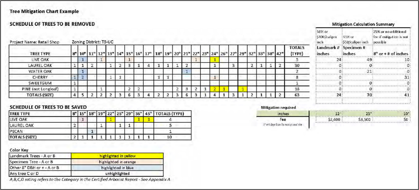
This is for illustrative purposes only and may be changed from time to time. An excel template for this planting schedule, along with typical tree planting details, can be found on the Planning Department's website.
(Ord. No. 2025/18, Exh. A, 8-19-2025)
5.2.1 - APPLICABILITY
A.
General:
1.
Tree Preservation: Consistent with the purpose of this section, priority shall be placed on retention of existing trees. All persons shall make all reasonable efforts to preserve and retain any existing Specimen and Landmark trees and established stands or groves of trees.
2.
Permit required for removal: Except as exempted in 5.2.1.B. below, a Tree Permit shall be required to remove or relocate any tree of 8" DBH or more, or a Specimen or Landmark tree, in the City. See Section 5.2.2.A for specific requirements.
a.
For single family and 2- and 3-family buildings on existing lots of record, a permit is only required for the removal of Specimen or Landmark trees.
3.
Permit required for pruning: A Tree Permit is required to prune any landmark tree as described in Table 5.3.1.A. Pruning must be done by, or under the guidance of, a certified arborist and shall meet ANSI A300 Standards for pruning.
4.
Trees Designated for Retention: A Tree Permit shall be required for the removal or relocation of any tree previously designated to be retained on an approved development plan.
5.
Enforcement: Failure to comply with the standards of this section shall be a violation of this ordinance and subject to the remedies and penalties specified in Section 12 of the Beaufort Code.
B.
Exemptions:
1.
The following activities are exempt from the standards in this ordinance and the requirements for a Tree Permit:
a.
Removal of severely damaged trees that have an imminent likelihood of failure or pose an immediate risk to person or property following a natural disaster such as a hurricane, tornado, ice or windstorm, flood, wildfire or any other such act of nature.
b.
Tree removal associated with forestry activities shielded from local development regulation in accordance with S.C. Code Ann. § 48-23-205, subject to the limitations on subsequent development in Section 5.2.2.C below. Forestry activities shall be regulated by a Forestry Management Plan approved by a certified South Carolina Forester.
c.
Removal of plant species designated as invasive by the South Carolina Forestry Commission, including, but not limited to, the following:
i.
Chinese Tallow (Triadica sebifera), Chinaberry Tree (Melia azedarach), Callery Pear (Pyrus calleryana), Camphor Tree (Cinnamomum camphora), Princesstree (Paulownia tomentosa).
2.
No Tree Permit is required where the proposed tree removal or alteration is reviewed and authorized in accordance with an approved Site Development Permit or Building Permit, though compliance with the standards in this section is required.
3.
Residential Lots of Record, as defined in Section 5.1.2, are exempt from the replacement planting and mitigation requirements of Section 5.5.2.C. Replacement planting and mitigation for tree removals in conjunction with development of these properties shall be regulated by Section 5.5.2.F below. All other requirements of this ordinance shall apply to such uses.
(Ord. No. 2025/18, Exh. A, 8-19-2025)
5.2.2 - ADMINISTRATION
Application Procedure: No Project Permit shall be issued, nor any development be commenced, for any site subject to the requirements of this article without an approved plan for all site elements including landscaping, lighting, and parking, as part of a greater development design review process as outlined in Article 9 (Development Review Procedures).
A.
Tree Protection Information in Applications:
1.
New Development:
a.
Applications for a Major Subdivision, Site Plan, Zoning and Building Permit or Certificate of Occupancy shall include at least the following information:
i.
A Tree Survey verified by a certified arborist, as described in subsection 5.2.2.A.3 below;
ii.
A brief written narrative of proposed plans for tree protection and justification for proposed removals and replacements, verified by a certified arborist;
iii.
A complete tree tally sheet listing exact species and diameter of trees on site;
iv.
For a Major Subdivision/Site Plan, a site plan showing utility lines, grading activities as well as building and pavement footprints (pervious and impervious surfaces) in relation to existing trees and denoting trees to be removed with an "X"; and
v.
A replacement tree replanting schedule, if required by Sections 5.3.2.G and 5.5.2 below.
b.
Applications for a Residential Building (Project) Permit shall include at least the following:
i.
A Tree Survey;
ii.
A certified arborist report including all Specimen and Landmark trees; and
iii.
A site plan showing utility lines as well as building and pavement footprints (pervious and impervious surfaces) in relation to existing trees and denoting trees to be removed with an "X."
2.
Existing Development. Applications for pruning or removal of trees on individual developed lots shall include a tree survey and a report from a certified arborist. An exception is granted on developed single-, two-, and three-family lots wherein a scope of work from a certified arborist is only required for removal of a Specimen or Landmark tree and pruning of a landmark tree. A tree survey shall never be required on developed single-, two-, and three-family lots.
3.
Tree Survey. The tree survey shall be in the form of a map or site plan, prepared and sealed by a registered land surveyor within two years of the date of application. The tree survey shall be at the same scale as the required site development plan and shall include the species and DBH of all trees 8-inch DBH or greater.
i.
All palmetto trees over eight (8) feet tall shall be measured in height, from the ground to the base of the frond initiation point.
B.
Authorization for Tree Removal:
1.
Permit Required: No person shall cause, suffer, permit or allow the following:
a.
The removal of a tree 8-inch DBH or greater or Specimen or Landmark Tree without first obtaining written authorization, to include all necessary permit(s), from the City to conduct the removal.
b.
Any encroachments, excavations, or change of the natural grade within the critical root zone (CRZ) of a protected tree, unless approved by the Codes Administrator, prior to the commencement of said activity, that the activity will not negatively impact the tree. The critical root zone area shall be defined as the greater of either:
i.
The area extending from the trunk of the tree to the outer-most point of the canopy or drip line; or,
ii.
All of the area starting at the trunk and extending to a distance of one (1) foot for each inch in diameter the trunk measures at four and one-half (4½) feet above ground level.
2.
Criteria: No authorization for the removal of any tree 8-inch DBH or greater or any Specimen or Landmark Tree shall be granted unless the applicant for removal of the tree demonstrates one or more of the following conditions in writing:
a.
Health: Whether or not the tree is dead, dying, or diseased according to a certified arborist report and verified by the City Official or designee.
b.
Elevated Risk: Whether or not the tree presents hazards that cannot be mitigated by any arboricultural procedures due to its deteriorated or damaged state.
c.
Developability: Whether or not the tree constrains reasonable development of the specific site, considering lot size, applicable setbacks, context, building type and use, stormwater requirements, and other relevant site development considerations.
3.
Permit Decision: Upon review of a completed application, the Codes Administrator shall approve, approve with conditions, or deny the permit.
a.
The applicant shall be notified of approval or denial, and if denied, informed of the reasons for denial.
b.
Permits may be issued conditionally, provided that the conditions are stated in writing and are appropriately referenced on the permit. Among such conditions may be stipulations that the developer of a site provide legal mechanisms which ensure the protection of Specimen and Landmark Trees after construction has occurred on the development. such mechanisms may include, but not be limited to, conservation easements, common open space requirements, vegetation or tree protection easements or buffers, deed restrictions and restrictions in homeowners' or condominium association documents.
c.
In the event questions or disputes arise concerning tree conditions, the City may call upon and consult with a certified arborist or other qualified professional to reach a decision. All appeals of staff decisions, and other form of administrative relief sought as a result of the application of these standards, shall be the purview of the Zoning Board of Appeals.
4.
Timing: The official shall be notified within five (5) business days prior to tree removal approved as part of a Site Plan.
5.
Permit posting: A copy of the approved tree permit shall be clearly posted on the job site during all phases of clearing and construction activities.
C.
Pre-Development Standards: Trees shall be marked with color ribbons, using blue ribbons to mark trees to be preserved, red ribbons for trees to be removed, and orange ribbons for elevated risk trees that are proposed to be removed (elevated risk trees will not count towards the overall required tree replacement). In heavily wooded areas, the official may allow large groups of trees to be preserved or removed to be marked with the appropriately colored ribbon extending around the perimeter of the group of trees.
D.
Tree removal without permit prior to Development: Nothing in this section shall be construed as to prevent the practice of forestry, as exempted from local development regulation by S.C. Code Ann. § 48-23-205. Forestry practiced in the City shall be accompanied by a Forestry Management Plan that has been approved by a certified South Carolina Forester.
1.
In addition to other provisions in accordance with [Article 12] of this Code, no application for subdivision plan (meaning sketch or preliminary plat), site plan, certificate of appropriateness or conditional use permit shall be accepted if, within twenty-four (24) months prior to said application, any trees on any property the subject of such application have been removed without legal authorization under this Code, whether by the present owner of the subject property of by a party who previously owned the subject property.
This twenty-four (24) month period shall be extended to sixty (60) months if said property is part of a development site on which more than 10 percent of the total trees have been cut.
2.
In addition, no such tree removal shall occur in the time between acceptance of such application and final approval without such application being subject to denial or revocation and the same penalties as above.
3.
An affidavit signed by the owner of the property at time of application submittal shall be submitted with all such applications testifying to the fact that no trees have been removed without legal authorization under this Code during these specified periods of time.
E.
Tree Protection and Restoration Plan (TPRP):
1.
A TPRP shall be submitted along with all other materials required at the time of application for Preliminary Plat review of a Major Subdivision, Site Plan or when submitting for a Zoning and Building Permit or Certificate of Occupancy. The TPRP shall comply with the requirements of Section 5.3 and include the following:
a.
A tree survey, performed by an engineer, certified arborist, or registered landscape architect, licensed by the State of South Carolina, identifying both the existing areas of canopy coverage, and all mature canopy trees located on the proposed development site prior to any disturbance;
b.
A graphic representation of the location of all mature canopy trees (noting the type and size) within fifty (50) feet of any area to be disturbed, indicating whether each is to be preserved or removed, and showing all protective measures such as fencing;
c.
Notes specifying that: 1) no disturbance is to occur within fifty (50) feet of mature canopy trees until all required protective measures are installed, inspected and approved; and, 2) all landscaping work occurring in the critical root zone area subsequent to the removal of protective measures is restricted to hand tools and machinery appropriately configured to limit negative impacts on existing root systems; and
d.
Mitigation/replanting. A description of the efforts proposed to be taken to offset or mitigate any impacts to the canopy, such as transplanting or planting replacement trees.
e.
Maintenance plan. All Specimen and Landmark Trees shall be maintained in conformance with the following:
i.
Required maintenance activities shall, for no less than a five (5) year period after completion of development, be set out in a plan approved by the City.
ii.
During the required maintenance period, the City Codes Administrator, or designee, shall have the right to conduct periodic inspections to ensure continuing compliance with the maintenance plan, and to confirm the health and viability of all required trees and plant material. In the event an inspection reveals a Specimen or Landmark tree to be missing, dead, or otherwise unhealthy and/or a threat to safety, notice of the situation, along with recommended actions for mitigation, shall be provided to the property owner, who shall either comply with the recommended actions, or, if appropriate, plant an approved replacement tree, within thirty (30) days.
2.
All trees and features required by an approved TPRP shall be installed prior to the issuance of a Certificate of Occupancy. The Code Administrator may approve a reasonable delay in installation, provided the developer provides a bond of an amount sufficient to provide for the installation of all required items.
F.
Landscaping Installation and Maintenance:
1.
Time for Installation of Required Landscaping:
a.
Time Limit: All required landscaping shall be installed in accordance with the required planting standards set forth in this Section before issuance of a Certificate of Occupancy unless the Code Administrator grants an extension to this time limit in accordance with Subsection 2, below.
2.
Extension:
a.
The Code Administrator may, for good cause shown, grant an extension to the above time limit, allowing a developer/owner to delay the installation of required landscaping. Circumstances that may warrant an extension include, but are not limited to, the following:
i.
Unusual environmental conditions, such as drought, cold weather, hurricanes, or over-saturated soil (deep mud);
ii.
The inappropriateness of the current season for planting the approved plant species;
iii.
Evidence that the approved plant species or required plant sizes are not commercially available and cannot be substituted within a reasonable time despite an applicant's diligent effort to secure the required materials; or
iv.
Completion of utility work occurring in a proposed landscaped area that is incomplete or delayed.
3.
Maintenance of Landscaping Materials: The owner shall be responsible for the maintenance of all landscape areas not in the public right-of-way. Such areas shall be maintained in accordance with the approved landscape plan or alternative landscape plan and shall present a healthy and orderly appearance free from refuse and debris. All plant life shown on an approved landscape plan or alternative landscape plan shall be replaced if it dies, is seriously damaged, or is removed.
a.
Damage Due to Natural Occurrence: If any vegetation or physical element functioning to meet the standards of this Section is severely damaged due to an unusual weather occurrence, natural catastrophe, or other natural occurrence such as damage by wild or domestic animals, the owner or developer may be required to replant or replace the vegetation or element if the landscaping standards are not being met. The owner shall have one growing season to replace or replant. In determining the extent of replanting or replacement required, the Code Administrator shall consider the type and location of the landscape buffer or required vegetation area as well as the propensity for natural re-vegetation.
b.
Protection during Operations: The owner or developer shall take actions to protect trees and landscaping from unnecessary damage during all facility and site maintenance operations. Plants shall be maintained in a way that does not obstruct sight distances at roadway and driveway intersections, obstruct traffic signs or devices, or interfere with the use of bikeways, sidewalks, or pedestrian trails.
c.
Natural Death: The natural death of existing vegetation within any required landscape area does not necessarily constitute a violation and does not require re-vegetation to replace the plant material unless the required landscape area no longer complies with the required standards of this Section. In no instance shall this provision be construed to prevent re-planting if, in the opinion of the Code Administrator, the required performance standard of the landscaping is not being met.
d.
Irrigation: Temporary spray irrigation systems may be used to establish seeded and/or planted areas.
4.
Monitoring of Compliance with Landscaping Standards:
a.
Inspections before Certificate of Occupancy: The Code Administrator shall inspect a development site before issuance of a Certificate of Occupancy for the development and such certificate shall not be issued if the landscaping required under this Section is not living or healthy or is not installed in accordance with the approved landscape plan.
b.
Additional Inspections: The Code Administrator or designee may inspect a development site during the second growing season following the installation of required landscaping to ensure compliance with the approved landscape plan or alternative landscape plan, and to ensure that the landscaping is properly maintained. Failure to maintain required landscaping (trees and shrubs) in accordance with the standards of this Section shall constitute a violation of this Development Code.
G.
Enforcement: Enforcement of this Section shall follow the requirements of Article 12 of this Code.
(Ord. No. 2025/18, Exh. A, 8-19-2025)
5.3.1 - SPECIMEN AND LANDMARK TREES
A.
Preservation of Specimen and Landmark Trees: Priority shall be placed on tree preservation and all persons shall make all reasonable efforts to preserve and retain existing Specimen and Landmark trees.
B.
Designation of Specimen and Landmark Trees: Certain trees, because of their species and size, are an asset to both the City and individual property owners and are hereby designated as "Specimen" and "Landmark" trees. Such trees shall be defined as those trees with a DBH equal to or greater than that indicated in the following table:
(Ord. No. 2025/18, Exh. A, 8-19-2025)
5.3.2 - TREE COVERAGE REQUIREMENTS
A.
Applicability and Canopy Standards: In addition to the standards laid out in Section 7.2.5 (Street Tree Planting Requirements), land or property subject to be developed, shall maintain a minimum baseline canopy coverage area as detailed in this Section.
All development proposed subsequent to the adoption of this section to require canopy coverage, with the exception of those activities specifically listed herein, shall be subject to the following standards.
Exemptions: The following development and activities shall be exempt from the requirements of this section:
a.
Removal and/or pruning of any tree not identified by these standards as a Landmark or Specimen Tree located on any residential lots of record by the owner.
b.
Mitigation efforts associated with clean-up activities following a natural disaster or other significant Acts of God; typically, the City will issue a period of waiver of the strict application of these standards for a specified period of time.
c.
Licensed plant and tree nurseries, and other duly permitted commercial tree growers, provided trees are planted or growing on the premises for sale to the general public in the ordinary course of business.
d.
Tree pruning and removal by duly constituted communication, water, sewer, electrical or other utility companies; or federal, state, or local government agencies; or engineers or surveyors working under a contract with said utility companies or agencies, provided removal is limited to those areas necessary for maintenance of existing lines or facilities, or for construction of new lines or facilities in furtherance of providing utility service to its customers. Additionally, all such activity must be conducted to avoid any unnecessary removal and, in the case of aerial electrical utility lines, shall not be greater than that specified by the National Electrical Code, or other appropriately adopted industry standard, for safe electrical clearances.
1.
Required Canopy Coverage for new development: All proposed non-residential, multi-family residential, and mixed-use development anticipated to have a land disturbance area greater than five thousand (5,000) square feet shall be subject to the minimum canopy coverage area requirements listed in the Minimum Canopy Coverage Requirements table below. Any single-family residential development consisting of two or less lots (existing single-family lots of record are exempt), or existing single family or duplex lots of record, are exempt from the required canopy coverage for development requirements.
a.
Encroachments: The appropriate approval body may authorize encroachments into any setback for the protection of any Specimen or Landmark tree, or the tree protection zone of any such tree.
b.
Parking Reduction: The appropriate approval body may authorize up to a 10 percent total parking reduction for development for the protection of any land landmark or specimen tree, or the tree protection zone of any such tree. Should the development protect over 30 percent of the existing tree canopy, a parking reduction of 20 percent on all standards may be authorized by the appropriate approval body. The appropriate approval body may reduce the required parking landscaping requirements of [Section] 5.7.8., including reduction or removal of parking lot islands, should they conflict with the preservation or protection of a Specimen or Landmark tree.
2.
Canopy Coverage for Development Calculation: For the purposes of this section, the canopy coverage area of a tree shall be defined as the area contained within the boundary established by a vertical projection along the outermost limit of the tree's crown at maturity. The canopy area cannot include any wetland or required drainage area within its calculation. The canopy coverage area of a parcel or development site shall be defined as the total of all non-conifer tree canopy areas, retained and/or planted, proposed to exist post - development. The following methods may be used to determine the tree canopy area:
a.
To Establish Existing Tree Canopy Area: For each mature tree proposed to be retained post - development, the radius (r) of the canopy area shall equal the distance from the center of the trunk to the outermost point of the tree's crown. Calculate the total canopy area (CA) with the following formula: CA = πr 2 . In the event existing site conditions are accurately reflected on aerial photography, the radius (r) may be determined through scaled measurements.
b.
To Establish Tree Canopy Area for Trees Proposed to be Planted: To determine the canopy area proposed to be planted, the radius (r) of each species of tree to be utilized, at twenty (20) years maturity, shall be determined based on accepted industry standards, and the total canopy area (CA) calculated (CA = πr 2 ).
c.
Alternative Methods: The Codes Administrator may approve other methods of calculation or sources of information, provided such alternatives are based on accepted industry practices, and utilize the best available information.
B.
Tree Protection in conjunction with Development: Developers shall avoid any activity during all phases of construction that may result in:
1.
Mechanical injuries to roots, trunk, and branches.
2.
Injuries by chemical poisoning.
3.
Injuries by grade changes.
4.
Injuries by excavations.
5.
Injuries by paving.
6.
Any willful action determined to be inconsistent with this standard, and which results in the injury of a Specimen or Landmark tree, shall constitute a violation of these regulations.
7.
Upon completion of construction, or as otherwise approved, fencing and other measures may be removed to allow for landscaping and final site work, provided all work is either conducted with hand tools, or with machinery utilized in a manner appropriate to protect against soil compaction and other damage to root systems.
C.
Protective Fencing: The owner shall be responsible for the erection of required protection fencing, and any other specified measures necessary to protect any existing or installed vegetation prior to the commencement of disturbance activity. At a minimum, all trees proposed to be preserved during development shall be protected with a sturdy and visible fence before clearing and grading begins. The following standards shall apply:
1.
The location of tree protection fencing and method of construction shall be noted on the landscape plan.
2.
Tree protection fencing shall be installed and remain in place and in good condition until all development activities are completed.
3.
The tree protection fence shall be located one (1) foot from the tree trunk for each one (1) inch in Tree Diameter Breast Height (DBH) with a minimum distance of ten (10) feet required from the edge of the trunk
4.
Tree protection fencing shall be constructed from any material substantial enough to prohibit and keep out vehicles, people, and all other activities associated with the development process.
5.
No soil disturbance or compaction, stock piling of soil or other construction materials, vehicular traffic, or storage of heavy equipment is allowed in the tree and root protection area(s) of trees to be retained.
D.
Tree Replacement: The following standards shall apply to all required tree replacements:
1.
Replacement species shall be the same species as each tree removed, provided the removed tree was a native species; all other replacement trees must be listed on the City's approved tree list.
2.
Replacement formula: one (1) square foot of replacement canopy (measured at maturity) for one (1) square foot of canopy removed.
3.
Single trees may be replaced with two (2) or more trees provided the caliper inch requirements measured at DBH are met.
4.
Replacement trees shall be planted within any part of the development site or on City property with staff consultation and approval.
5.
If it is determined that a site cannot sustainably support all or a portion of the required tree replacement pursuant to Section 5.5.2.B, then a fee based on the mitigation schedules in Sections 5.5.2.B or 5.5.2.C shall be paid to the City for the purposes of tree planting and maintenance.
E.
Utilities and Agencies: Utility companies, governmental agencies, and city agencies in the course of constructing or maintaining easements or rights-of-way for water, sewage, electricity, gas, drainage, telephone, or television, shall execute an agreement with the city that:
1.
Recognizes the need to minimize trimming of hardwood overstory trees that do not significantly interfere with the intended purpose of construction or maintenance.
2.
Establishes, to the extent practicable, design guidelines for construction and maintenance that identify the saving of hardwood overstory trees as a factor to be considered in the design process.
3.
Establishes guidelines to avoid limbing, topping, or severe pruning of trees whenever reasonably practicable, and where it is unavoidable, according to ANSI A300 Standards, which may include tree removal.
4.
Provides for a consultation process with the city prior to the commencement of major construction or maintenance or the removal of any Specimen or Landmark tree.
F.
Waiver for Emergency: In the event that a tree poses a threat to public safety due to death, disease, or damage resulting from events including, but not limited to fires, floods, hurricanes, other natural disasters, intentional harm, or negligence, the Codes Administrator may waive the requirements of Section 5.4.1. As soon as it is feasible after the waiver, the administrator shall issue written findings outlining the threat to public safety that prompted the waiver. The administrator may require that the owner of the site replace the tree when the findings conclude that the removal was necessitated by intentional harm or negligence.
G.
Normal Tree Maintenance: Nothing in this Code shall restrict normal tree maintenance by a property owner (including removal of dead wood and branches or limbs that endanger life or property) for any tree except for Landmark trees upon which any pruning must be done according to Section 5.4.4.A.
(Ord. No. 2025/18, Exh. A, 8-19-2025)
5.3.3 - TREE ROOT PROTECTION ZONE (TPZ) REQUIREMENTS
A.
Applicability: A permanent "tree protection zone" (TPZ) surrounding preserved trees shall be established to protect the underground root system. This area shall not be disturbed at any time before, during, or after construction.
B.
Size and Shape: The minimum TPZ shall be as follows:
1.
A circle with a radius of one (1) foot per 1 inch of DBH, ideally measured from the leading edge of the root flare.
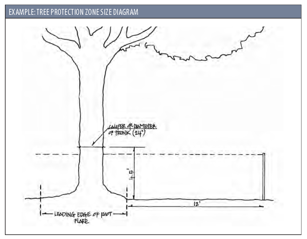
2.
The TPZ shall be indicated on both site and landscape plans for all trees shown to remain.
C.
Adjustments and Exceptions:
1.
The size and shape of the TPZ may be adjusted where any of the following occur: root pruning, root invigoration, restoring the natural grade of the soil, W.A.N.E. feeder, porous paving materials, and/or a tree well.
2.
The size and shape of the TPZ may be adjusted as needed to accommodate construction practices. The reduction of minimum radius of TPZ may require additional remediation measures as recommended and performed by a certified arborist prior to site disturbance.
D.
Tree Wells: In general, tree wells are discouraged, unless approved by the city arborist. If they are used, a tree well shall encompass at least half the area beneath the canopy of the tree and extend in every direction, no less than halfway from the trunk to the tree's dripline. A tree root aeration system shall be installed that shall extend from 2 feet inside the tree well wall to the dripline of the canopy.
E.
Pre-Construction Treatment: Based on the certified arborist report, the following may be required to retain trees and facilitate their health during and after the construction process: root pruning, fertilization, and root invigoration. These practices, as applicable, shall be performed for a minimum of 3 months prior to site disturbance.
F.
Prohibited Activities: The following are prohibited within all TPZs:
1.
Placement of building materials, dirt, debris, oils, paints, or any other materials, equipment, or vehicles.
2.
Irrigation pipe installation.
3.
Grading, with the exception of a 2-inch cut or 2-inch fill of topsoil, sod, or mulch.
4.
Paving for roadways, driveways, or sidewalks.
5.
Cutting of roots for installation of utilities or drainpipe of any kind.
6.
Exception: If excavation work for water line installation within a TPZ is deemed necessary during construction operations, such excavation shall be accomplished utilizing hand excavation methods that remove soil around tree roots without severing them.
G.
Damages and Reparations: When encroachment or construction activity within a TPZ has damaged or destroyed a tree or tree growing site, the city, at the discretion of the Codes Administrator, may seek mitigation for the value of any damaged trees within a TPZ, per the Mitigation Schedule in Section 5.5.2, and/or may require treatments or additional plantings. Such mitigation shall occur prior to the issuance of a Certificate of Occupancy.
(Ord. No. 2025/18, Exh. A, 8-19-2025)
5.3.4 - STREET TREE PLANTING REQUIREMENTS
Street tree planting requirements are established in Section 7.2.5.
(Ord. No. 2025/18, Exh. A, 8-19-2025)
5.4.1 - BUFFER TYPES
Below table describes five (5) different Buffer Types in terms of their function, opacity, width, and planting requirements. The planting requirements should be used as a guide to achieve an aesthetically pleasing landscaped buffer. Either of the options under a specific buffer type may be used at the discretion of the developer/applicant. If the square footage of an existing building on a site is being increased by more than 50 percent then the buffers must be brought into compliance with the standards in this table.
Following provisions shall be applied, if necessary:
A.
Required overstory trees shall be distributed and spaced to maximize their future health and effectiveness as buffers. Other required vegetation shall be distributed within the buffer as appropriate to the function of the buffer.
B.
Where an adjacent use is designed for solar access, understory trees may be substituted for overstory trees.
C.
Fences or walls within an adjacent street or use buffer shall comply with the standards of Section 5.8.
D.
A berm may be provided in conjunction with the provision of a hedge, fence, or wall to achieve height requirements, provided its side slopes do not exceed a ratio of three horizontal feet to one vertical foot and the width of its top is at least one-half its height.
E.
If a buffer length is greater or less than 100 linear feet, the planting requirements shall be applied on a proportional basis, rounding up for a requirement that is 0.5 or greater, and down for a requirement that is less than 0.5. For example, if the buffer length is 150 linear feet, and there is a requirement that 5 overstory trees be planted every 100 linear feet, 8 overstory trees are required to be planted in the buffer (1.5 x 5 = 7.5, rounded up to 8).
TYPE A BUFFER This buffer includes low-density screening designed to partially block visual contact and create spatial separation between adjacent uses or between development and adjacent streets with low traffic volumes. | |
Option 1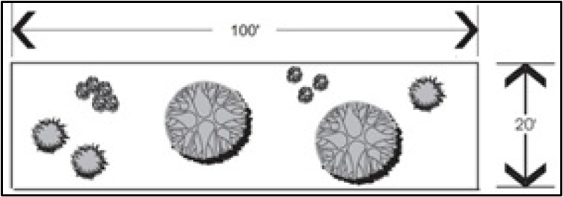 |
• Depth: 20 feet
• Overstory trees: 2 every 100 linear feet • Understory trees: 3 every 100 linear feet • Evergreen shrubs: 8 every 100 linear feet |
Option 2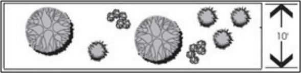 |
• Depth: 10 feet
• Overstory trees: 2 every 100 linear feet • Understory trees: 4 every 100 linear feet • Evergreen shrubs: 10 every 100 linear feet |
TYPE B BUFFER This buffer includes low- to medium-density screening designed to create the impression of spatial separation without significantly interfering with visual contact between adjacent uses or between development and adjacent minor roadways. | |
Option 1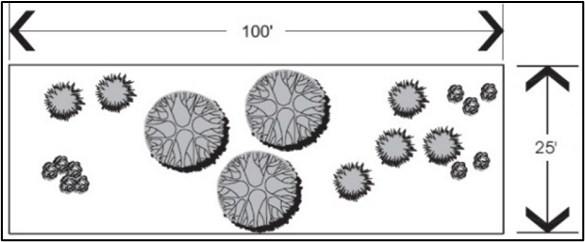 |
• Depth: 25 feet
• Overstory trees: 3 every 100 linear feet • Understory trees: 6 every 100 linear feet • Evergreen shrubs: 10 every 100 linear feet |
Option 2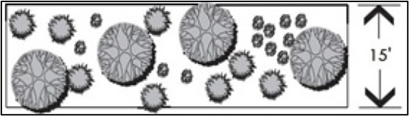 |
• Depth: 15 feet
• Overstory trees: 4 every 100 linear feet • Understory trees: 8 every 100 linear feet • Evergreen shrubs: 12 every 100 linear feet |
TYPE C BUFFER This buffer includes medium-density screening designed to eliminate visual contact at lower levels and create spatial separation between adjacent uses. | |
Option 1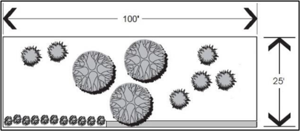 |
• Depth: 25 feet
• Overstory trees: 3 every 100 linear feet • Understory trees: 5 every 100 linear feet • A solid wall or fence at least 3 feet high or a solid evergreen hedge at least 3 feet high and 3 feet wide |
Option 2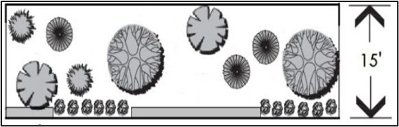 |
• Depth: 15 feet
• Overstory trees: 4 every 100 linear feet • Understory trees: 6 every 100 linear feet • A solid wall or fence at least 3 feet high or a solid evergreen hedge at least 3 feet high and 3 feet wide • At least 50% of all trees must be evergreen |
TYPE D BUFFER The buffer includes high-density screening designed to eliminate visual contact up to a height of six (6) feet and create a strong spatial separation between adjacent uses. | |
Option 1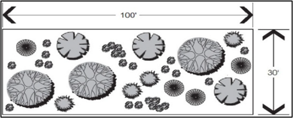 |
• Depth: 30 feet
• Overstory trees: 5 every 100 linear feet • Understory trees: 6 every 100 linear feet • Evergreen shrubs: 35 every 100 linear feet and at least 6 feet high at maturity • At least 50% of all trees must be evergreen |
Option 2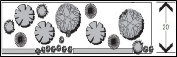 |
• Depth 20 feet
• Overstory trees: 6 every 100 linear feet • Understory trees: 8 every 100 linear feet • A solid wall or fence at least 4 feet high or a solid evergreen hedge at least 4 feet high and 3 feet wide. • At least 50% of all trees must be evergreen |
TYPE E BUFFER This buffer provides greater spacing and high-density screening designed to define "green" corridors along major roadways. | |
Option 1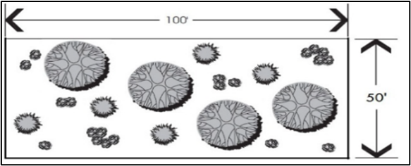 |
• Depth: 50 feet
• Overstory trees: 4 every 100 linear feet • Understory trees: 5 every 100 linear feet • Evergreen shrubs: 30 every 100 linear feet and at least 6 feet high at maturity |
Option 2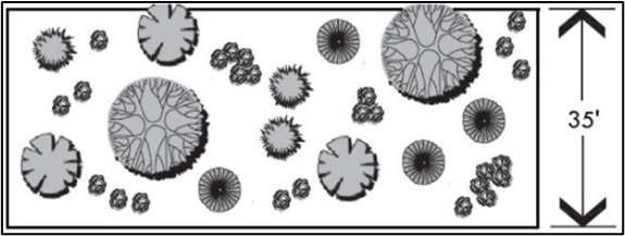 |
• Depth: 35 feet
• Overstory trees: 5 every 100 linear feet • Understory trees: 7 every 100 linear feet • Evergreen shrubs: 35 every 100 linear feet and at least 6 feet high at maturity • At least 50% of all trees must be evergreen |
(Ord. No. 2025/18, Exh. A, 8-19-2025)
5.4.2 - FRONT BUFFER REQUIREMENTS ALONG MAJOR CORRIDORS
In addition to the buffer requirements above, buffers shall be provided along all parcel boundaries that abut these roads established in the following table.
* Requirements based on the design of the building and how it addresses the street may be waived or altered by the applicable approval body.
A.
Maintenance of Required Plantings: Trees and shrubs shall not be pruned in any manner that would significantly diminish the desired softening character of the front buffer, except in accordance with standard horticultural practice, or as required at driveway sight triangles. See Appendix A for more information on best practices for pruning.
B.
Existing Vegetation:
1.
If a buffer area has existing trees, they shall be preserved and be used as part of the buffer to comply with the buffer standards of this Ordinance. Where groupings of native shrubs are present, their preservation with minimum disturbance is required. Any clearing or other work in buffers must have the prior approval of the Code Administrator.
2.
In order to preserve existing vegetation and to restrict activities within a buffer, protective fencing shall be installed during development activity.
3.
Existing vegetation that is preserved shall not be limbed up from the ground more than five feet to the lowest branches, except:
a.
Vegetation at intersections may be limbed up to a greater height to ensure compliance with Sight Triangles; and
b.
If understory planting is proposed, the Code Administrator may allow existing vegetation to be limbed up to a height that will provide adequate sunlight to plants.
4.
The removal of invasive species shall be allowed with an approved replanting plan, if needed.
C.
Buffer Materials: At the time of planting, overstory and understory trees included as part of required buffers shall be no less than 2.5 caliper inches; evergreen shrubs shall be at least three feet in height above ground level. All buffer plantings must be native species of plants.
D.
Development Within Required Buffers: Development is prohibited within required buffers except in accordance with this subsection. The following activities may occur in required buffers, unless expressly prohibited elsewhere in this Ordinance, or by the Planning Commission as part of an approved Site Plan:
1.
Street or driveway access, provided it runs approximately perpendicular to/from the adjacent street right-of-way or common property line.
2.
Walkways, pathways, trails, benches, bike racks, and other elements associated with passive recreation or the provision of continuous pedestrian and bicycle connections between adjoining properties, provided all landscaping as required by this Section is provided and the Codes Administrator determines that installation or maintenance of such elements will minimize impacts on to required vegetation to the maximum extent.
3.
Lighting fixtures.
4.
Stormwater Management: Stormwater and drainage facilities that permit vegetation may encroach into the buffers if the planting requirements are fulfilled.
5.
Signage, lighting fixtures, and street furniture.
6.
Fountains, plazas, sculptures, and similar features that are part of publicly owned facilities, where approved by the Codes Administrator.
7.
Service and utility lines and minor facilities (e.g. water, sanitary sewer, electrical, telephone, natural gas, cable, storm drainage lines, utility boxes and pedestals), subject to the following standards:
a.
Such lines generally shall run approximately perpendicular to/from the adjacent street right-of-way or common property line. If they must be installed approximately parallel to the street right-of-way or property line, the easement for the lines may be included as part of a required buffer if the easement allows the vegetation or structures necessary to meet buffer screening requirements and provides the requisite visual separation in a manner that is aesthetically acceptable; otherwise, additional buffer width shall be required to provide the space needed for the required buffer screening.
b.
Permission for easement and right-of-way disturbance and clearings for such utility and service lines and facilities shall be more favorably considered when such activity is consolidated with vehicular access routes.
(Ord. No. 2025/18, Exh. A, 8-19-2025)
5.4.3 - SIDE AND REAR BUFFER REQUIREMENTS
Landscaped perimeter buffers shall be preserved or established along the front of the sites located within Conventional Districts, and along the side and rear boundary lines along all districts. The buffers are based upon a specific parcel's underlying zoning designation and that of the parcel it abuts. Where the buffer requirements in this table are in conflict with the corridor buffer requirements, the greater buffer width and/or plantings shall apply.
All residential developments shall have a Type D rear and side yard buffer where an adjoining use is other than that same residential type, unless a different buffer requirement is imposed by the Planning Commission.
All non-residential or mixed-use developments adjoining a residential use shall have a Type D rear and side yard buffer, unless a different buffer requirement is imposed by the PC.
(Ord. No. 2025/18, Exh. A, 8-19-2025)
5.4.4 - PARKING LOT SCREENING AND LANDSCAPING
A.
Screening: All parking areas shall be screened from the public right-of-way or primary vehicular access point(s) — if the parking area does not front a public right-of-way — with evergreen shrubs, walls, fences, or some combination thereof. Screening is not required at areas designated for signage, or pedestrian or vehicle access points. Screening devices shall be installed at the height and opacity specified in the table below:
B.
Landscaping:
1.
Applicability: This applies in all Districts. The Planning Commission may grant a reduction of 30 percent of these requirements.
2.
Priority: In parking lot design, priority should be given to working around existing trees, and then secondarily creating areas where new plantings would be required.
3.
Landscaped Peninsulas and Medians Shall be Established as Follows:
a.
Size: Landscaped peninsulas with a plantable area of at least 12 feet wide by 18 feet long area shall be established parallel to parking spaces and at the end of the parking aisle in order to separate the last space from any adjacent driveways.
b.
Planting: At least one (1) broad-leaved overstory tree shall be provided within each landscaped peninsula. All landscaped peninsulas and medians shall be landscaped with mulch, sod, shrubs, or ground cover vegetation. See Appendix A for recommended plantings list.
c.
Specific to Transect Zones: No more than 12 continuous parking spaces shall be permitted in a row without an interrupting landscaped peninsula, except in the following circumstances:
i.
The parking lot is gravel, or covered with other soft pervious pavement materials, and spaces are not striped; or
ii.
There is a landscaped median.
d.
Specific to Conventional Zones:
i.
No more than 10 continuous parking spaces shall be permitted in a row without an interrupting landscaped peninsula.
ii.
On the interior of parking lots, landscaped medians between all head-to-head" rows of parking are required.
iii.
Where wheel stops are to be used for the protection of landscaped medians, the minimum median width shall be 6 feet. Plantings in such medians shall be limited to a combination of turfgrass or groundcover, palms, and shrubs that have a mature height and spread of 4 feet or less.
iv.
Where wheel stops are not used for the protection of landscaped medians the minimum median width shall be 9 feet. Plantings in such medians shall be limited to a combination of turfgrass or groundcover, palms, understory trees and/or shrubs which have a mature height and spread of 5 feet or less.
v.
Shrub coverage in the medians and peninsulas shall be at least 50 percent.
(Ord. No. 2025/18, Exh. A, 8-19-2025)
5.5.1 - GENERAL REQUIREMENTS
A.
Trees planted shall be botanically compatible with local conditions, healthy, and disease-and pest-free. Plant materials shall conform to the standards established by the American Association of Nurserymen in the "American Standard for Nursery Stock" (ASNS).
B.
Irrigation shall be required in all new developments unless the Code Administrator specifically waives this requirement, based on the unique character of the development and/or the nature of the proposed plant material.
1.
Exception: New construction in T3 zones, and single-family residential construction in T4 zones on new or existing lots, is not required to have irrigation.
C.
Landscaping shall be maintained in good condition and shall be kept free from refuse and debris.
D.
Installed trees must adhere to the grades and standards outlined in the ASNS. The minimum size at installation of all trees and shrubs planted pursuant to the requirements of this Code is as follows:
1.
Overstory trees: 2.5 caliper inches (measured at 6 inches above grade).
2.
Understory trees: 8 feet high.
3.
Shrubs: Shrubs must be reasonably projected to grow to maturity (i.e., to meet specific size or coverage requirements) within 3 years, unless otherwise specified herein.
E.
Existing healthy shrubs and trees may be used to satisfy any requirements of this Code, provided they meet the minimum size requirements outlined in Section 5.5.1.D.
F.
Use of existing vegetation, native plants, drought-tolerant plants, and water conserving irrigation techniques, such as use of a rain sensor, and re-use of rainwater, is encouraged. Preservation of groupings of trees (e.g., tree save areas) is encouraged and generally favored over preservation of scattered individual trees.
G.
Where understory trees are specified, preserved, or planted, broad-leaved overstory trees may be substituted on a one-to-one basis to satisfy the requirement.
H.
In conjunction with any development, grass or ground cover shall be planted, or mulch installed to a depth of 3 inches, on all portions of exposed bare ground not otherwise developed or landscaped. This shall include planting strips and other areas within rights-of-way that are contiguous to the development site. Grass and/or ground covers shall provide 75 percent coverage within 1 calendar year from the time of planting. Gravel or crushed shell may be approved as an acceptable ground cover if it is coordinated with the overall site and landscape design; however they shall not be used as a substitute for organic mulch in plant beds. The use of dyed hardwood or synthetic material is prohibited.
I.
All earthen drainage structures with a maximum gradient of 3:1 may be hydroseeded or sodded. Ditch and pond banks with slopes greater than 3:1 shall be treated with erosion control fabric or matting and/or receive erosion resistant landscaping materials such as ground covers or wetland plant species.
J.
Landscaping shall not obstruct the view of motorists using any road or driveway.
K.
Where site conditions are inappropriate for an overstory tree, due to existing utilities, building design, or other conflicts either above or below ground, up to 2 understory trees may be substituted for 1 overstory tree.
L.
Severe trimming, pruning, or other maintenance that results in significant alteration of the natural shape of a tree or modification of the central leader (including "lollipopping," "heading," or similar techniques) is prohibited, except in conjunction with public utility maintenance.
(Ord. No. 2025/18, Exh. A, 8-19-2025)
5.5.2 - REPLACEMENT PLANTING AND MITIGATION
A.
Applicability:
1.
Where the Codes Administrator approves removal of trees for new development.
2.
Where any vegetation, existing or proposed, used to comply with the requirements of this section, does not survive in a healthy condition.
3.
When a tree protected under this ordinance is removed from a property without permission from the Codes Administrator, is significantly damaged during construction, or significantly declines and is recommended for removal by a certified arborist at the end of the two-year maintenance guarantee period.
B.
Replacement Planting and Mitigation: The tree mitigation fee is established to allow tree planting elsewhere in the City in cases where the requirements for retention of existing trees cannot be achieved. Where a certified arborist determines that a site cannot sustainably support all, or a portion of, the required replacement, due to the size and shape and/or structures and/or viable site constraints, a fee based on the mitigation schedules in subsections 5.5.2.C or 5.5.2.F below shall be paid to the City for the purposes of tree planting and maintenance.
C.
Replacement and Mitigation Schedule: With the exception of Residential Lots of Record, replacement plantings and mitigation shall be according to the following chart:
1.
Timing of Fee Payment: All required tree mitigation fees shall be paid prior to issuance of a Site Development Permit or Building Permit.
2.
Tree Replacement Fund: The City shall establish and maintain a separate accounting fund for the deposit of tree mitigation fees paid in lieu of providing required replacement trees. Such funds need not be segregated from other City monies for banking purposes. Any yield on such accounting fund shall accrue to that fund and shall only be spent on trees on publicly owned and maintained property. Qualifying debits include the cost of trees, installation of trees, and maintenance of trees.
D.
The provisions of this section shall apply to all projects, regardless of the date the Site Development Permit or development approval was issued.
E.
Exemption. Any Specimen or Landmark tree that fails due to a natural catastrophe shall be exempt from the requirements of this section.
(Ord. No. 2025/18, Exh. A, 8-19-2025)
5.6.1 - PURPOSE
The purpose of this section is to regulate and ensure the provision of adequate parking and access for bicycles and motor vehicles. The section also provides options for adjusting parking requirements and providing parking alternatives. These standards ensure that the parking needs of new land uses and development are met, while being designed and located in a manner consistent with the desired character and development patterns of the community.
(Ord. No. 2025/18, Exh. A, 8-19-2025)
5.6.2 - APPLICABILITY
The parking standards of this section shall apply to new developments and when a structural alteration in an existing building produces an increase in dwelling units, guest rooms, floor area, seating or bed capacity.
(Ord. No. 2025/18, Exh. A, 8-19-2025)
5.6.3 - BICYCLE PARKING
A.
Applicability: Bicycle parking is required everywhere except in the T3 zoning district, in T4 districts in detached single-family residential developments, and in the LI district. In the T5 district, the Codes Administrator has the authority to waive the bicycle parking requirement if it is not appropriate or feasible.
B.
Location and Configuration: Bicycle parking shall be placed in a usable and accessible location. The rack(s) shall be placed so that neither the rack nor the bike within it blocks pedestrian or vehicular access ways and shall be maintained and kept clean and in proper working order at all times.
C.
Size: Developments shall provide either racks for 5% of the number of required off-street vehicular parking spaces or 2 bicycle parking spaces, whichever is greater. Spaces shall be a minimum of 2 feet by 6 feet.
(Ord. No. 2025/18, Exh. A, 8-19-2025)
5.6.4 - PARKING SPACE REQUIREMENTS
A.
Minimum Number of Parking Spaces: The number of motor vehicle parking spaces required shall be determined by the table below. Uses not listed in the following chart shall use the parking requirement for the most similar use, as determined by the Code Administrator.
1.
Except at the discretion of the Planning Commission, when shown by the applicant that a departure from the standards is necessary, such as through a parking study.
B.
Credits for On-Street Parking:
1.
On-street parking spaces along the lot frontage may count toward the minimum number of required parking spaces if needed.
2.
For multi-family dwellings over 3 units, and for commercial buildings over 4,000 square feet, adjacent existing on-street parking within 400 feet from the property line may be used to count toward the on-site parking requirement if needed.
3.
Where on-street parking does not exist, additional on-street parking spaces meeting City standards (see Appendix C) may be constructed to fulfill all or part of the on-site parking requirement. This must be approved by the Technical Review Committee and any outside agencies, as appropriate.
4.
On a block face where formalized on-street parking is available, single-family and 2-family dwellings, and nonresidential uses with less than 4,000 square feet of space, and any structure listed as "Contributing" on the "1997 Beaufort County Above Ground Historic Resources Survey," or most recent historic survey, shall be exempt from these off-street parking requirements.
C.
Maximum Number of Parking Spaces: The maximum number of off-street parking spaces shall be as follows:
1.
For buildings with a footprint less than or equal to 60,000 gross square feet, no more than 140 percent of the required minimum number of parking spaces are permitted, except at the discretion of the Planning Commission, shown by the applicant that a departure from the standards is necessary, such as through a parking study
2.
For buildings with a footprint greater than 60,000 gross square feet, no more than 125 percent of the required minimum number of parking spaces are permitted, except at the discretion of the Planning Commission, shown by the applicant that a departure from the standards is necessary, such as through a parking study.
3.
Exceptions:
a.
Group Housing or Multi-Family buildings built specifically to accommodate student housing are permitted a maximum of 1 parking space per bedroom, plus an additional 125 percent for guest parking.
b.
Uses within the IC district.
D.
Off Site Parking: Required parking may be provided off site if the following standards are met:
1.
Required parking may be provided in off-street parking facilities on another property within 250 feet of the site proposed for development, as measured along street rights-of-way. Parking further than 400 feet may be approved by the Codes Administrator if it is in conjunction with a plan to provide access to the lot (e.g., shuttle service).
2.
In any transect-based district, required parking may not be located along a major thoroughfare without being screened from the street by buildings.
3.
Unless an exception is granted by the Planning Commission, pedestrian access between the use or the site and the off-premise parking area shall be via a continuous sidewalk or walkway, not separated by a street.
4.
The owner shall provide a written parking agreement reflecting the arrangement with the other site.
(Ord. No. 2025/18, Exh. A, 8-19-2025)
5.6.5 - PARKING EXCEPTIONS
A.
In the T5-DC District, all non-residential uses, except for motels/hotels/extended stay guest accommodations, shall be exempt from the off-street parking requirements of this section. Where such uses elect to provide off-street parking, it shall meet the design requirements of this section.
B.
Any structure being reoccupied that is listed on the city's "Vacant and Abandoned Structures" list shall be exempt from these off-street parking requirements if on-site parking cannot be accommodated.
C.
In the Boundary Street Redevelopment District, see Section 2.7.3.E for parking requirements.
(Ord. No. 2025/18, Exh. A, 8-19-2025)
5.6.6 - SHARED PARKING AND PARKING REDUCTIONS
A.
Shared Parking—Two Uses: When 2 use types share common parking facilities, the minimum amount of required parking may be reduced. The minimum amount of required parking shall be calculated as the sum of the required parking for the 2 uses separately, divided by the factor listed in the table below.
EXAMPLE: A mixed-use building that typically requires 10 residential spots and 20 retail spots may be reduced as follows: (10+20) / 1.2 = 25 spots. This is a 5-spot reduction due to the shared parking factor.
B.
Shared Parking—Three or More Uses: When 3 or more use types share common parking facilities, or if a use type is not listed in Table 5.6.4., the amount of required parking may be reduced as appropriate in accordance with Section 5.6.6.C below.
C.
Parking Reductions:
1.
The Code Administrator may grant a reduction in the parking requirements set forth in this section in the following cases:
a.
Where uses in the same or adjoining development, having different peak hour demand, seek to share parking, the applicant must submit to the Codes Administrator an analysis and substantiated projections of peak parking demand — based on historic data from other locations or a similar use — for the entire development to justify the shared use of parking spaces for separate uses.
b.
Where the special nature of a certain development (e.g., special types of housing projects inhabited by persons with low or no automobile ownership) does not require the amount of parking listed in Section 5.6.4.
c.
Where fewer parking spaces are needed due to location and use — e.g., if there is a high concentration of residential units adjacent to a neighborhood-serving use, a parking reduction may be warranted.
2.
The Codes Administrator shall consider the following in determining whether a reduction is warranted:
a.
The likelihood that the reduced number of parking spaces can satisfy demand.
b.
The amount of time during the year when the number of spaces provided may be insufficient and the amount of resulting parking overflow.
c.
The impact of periodic overflows upon the public streets and other parking facilities.
d.
The nature of surrounding land uses, character of surrounding road system, and nearby circulation pattern.
3.
In all cases, the burden to demonstrate that a reduction in parking requirements is warranted shall rest with the applicant.
(Ord. No. 2025/18, Exh. A, 8-19-2025)
5.6.7 - PARKING LOT DESIGN
A.
General Design Standards:
1.
Design: Parking stalls shall be located in areas that will not require backing into access driveways or streets, except where allowed for residences, or when no other practical alternative exists, as determined by the Codes Administrator.
a.
Parking Stall Dimensions: Unless an exception is granted by the Planning Commission, off-street parking spaces shall be at least 9 feet wide by 18 feet long, exclusive of access or maneuvering spaces.
b.
Travel Lane Dimensions: Travel lanes shall not exceed 24 feet wide for 2-way traffic, except in specific areas that may require additional room for truck access. A minimum of 20 feet clear between parking spaces shall be provided for 2-way traffic. One-way traffic may be permitted to have travel lanes width reduced to 16 feet if approved by the fire marshal.
2.
No Storage: Minimum parking areas shall be kept free of material storage, including portable containers, and outdoor display/sales, except on a temporary basis as part of an approved Temporary Use (see Section 3.13).
3.
Maintenance: Parking areas shall be maintained to provide for vehicle access and shall be kept free of litter, debris, and potholes.
4.
Identified as to Purpose and Location: Off-street parking areas with 4 or more spaces, and off-street loading areas, shall include painted lines, wheel stops, or other methods of identifying individual parking spaces and loading areas and distinguishing such spaces from aisle and other circulation features.
5.
Parking Space Marking: The individual parking spaces in a lot shall be delineated in all parking lots except those utilizing road bond, gravel, grass, or other vegetative surfacing. Such parking lots shall delineate parking spaces with a wheel stop or vegetative buffer.
6.
Front Yard Parking: Where Section 7.2.3 (Lot Access Standards) permits driveways, they may be used for front yard parking areas, but the width of such front yard parking areas shall be limited to the driveway width specified in that section.
B.
Pedestrian Corridors in Parking Lots: Parking lots with 40 spaces or greater shall be designed to separate pedestrian travel from vehicles. They shall include designated pedestrian walkways to provide safe access to building entries for pedestrians.
1.
Perimeter sidewalks — typically located on public rights-of-way— and/or interior parking lot pedestrian corridors may be utilized to provide the required pedestrian access.
2.
Pedestrian pathways (if provided) shall be a minimum 5 feet in width.
3.
Where parking is located between a public entrance and the fronting sidewalk, a pedestrian pathway shall be provided, following the shortest practical route across the parking lot between at least 1 such entrance on each side of the building facing a public street.
4.
Pedestrian pathways shall be clearly delineated with striping. This may also be accomplished with the use of paving materials that differ from that of vehicular areas, striping or other similar methods.
C.
Connectivity:
1.
Wherever feasible, adjoining parking lots (except those serving residential buildings of less than 4 units) shall be interconnected, or designed to interconnect in the future.
2.
Where a parking lot connection is provided, an easement for ingress and egress to adjacent lots shall be recorded by the property owner with the Beaufort County Register of Deeds.
3.
When parking lots are connected, one or more of the following incentives may be utilized, at the discretion of the applicant:
a.
The side or rear setback adjacent to the connection may be reduced to 5 feet.
b.
An additional 10 percent of parking spaces exceeding the 140% maximum may be provided.
c.
Impervious surface may be increased by 5 percent.
D.
Materials:
1.
Parking spaces and driveways shall be paved with a material that supports the anticipated load and context. Pervious or semi-pervious paving materials are encouraged. Where possible, such materials shall be used in combination with on-site stormwater control devices.
2.
Parking provided above the minimum required parking spaces shall be with a pervious material.
E.
Accessible Parking: All parking facilities that require accessible parking spaces shall ensure that a portion of the total number of required parking spaces shall be specifically designated, located, and reserved for use by persons with physical disabilities, in accordance with the standards in the federal American with Disabilities Act (ADA).
F.
Tandem Parking and Residential Driveways: See Section 7.2.3.D.2.b.
(Ord. No. 2025/18, Exh. A, 8-19-2025)
5.6.8 - STRUCTURED PARKING
See Section 4.5.11.
(Ord. No. 2025/18, Exh. A, 8-19-2025)
5.6.9 - PARKING OF SPECIFIC VEHICLES
A.
Parking, Storage or Use of Campers or Other Major Recreation Equipment:
1.
No major recreational equipment shall be parked or stored in any T3 or T4 district in a manner which poses a nuisance or constitutes a hazard. When parked in a permanent location, such equipment shall observe all setbacks, yard, and other requirements set forth within the districts in which they are located.
2.
Parking or storage of recreational equipment shall not be permitted in any district between the street and the building face. No such equipment shall be used for living, sleeping, or housekeeping purposes when parked or stored in any location not approved for such uses.
B.
Vehicles Without License Plates: Any vehicle or trailer of any kind requiring licenses, but without current plates, shall not be parked other than in completely enclosed buildings.
C.
Commercial Vehicles:
1.
Trucks, tractors, or tractor-trailers having a capacity of more than a 8,000 pound load, front- and rear-end loaders, or any kind of commercial, industrial, agricultural and transportation vehicles/equipment used primarily for business purposes, shall not be parked or stored on or adjacent to any parcel in a T3 or T4-HN district for purposes other than unloading, loading, or delivery services.
2.
Automobiles, small trucks, vans, vehicle trailers permitted in conjunction with an approved home occupation (1 per home occupation), and recreational vehicles, utilized for personal or business use, are excluded from the provisions of this section.
(Ord. No. 2025/18, Exh. A, 8-19-2025)
5.7.1 - PURPOSE
The standards set forth in this section are designed to:
1.
Ensure that all site lighting is designed and installed to maintain adequate lighting levels on-site;
2.
Prevent excessive light spillage and glare directed at adjacent properties, neighboring areas, and motorists; and
3.
Provide security for people and land.
(Ord. No. 2025/18, Exh. A, 8-19-2025)
5.7.2 - APPLICABILITY
The provisions of this article shall apply to all development with the following exemptions:
A.
All temporary emergency lighting needed by the police or fire departments or other emergency services, as well as all vehicular luminaires, shall be exempt from the requirements of this Code.
B.
All hazard warning luminaires required by federal regulatory agencies are exempt from the requirements of this article, except that all luminaires used must be red and must be shown to be as close as possible to the federally required minimum lumen output requirement for the specific task.
C.
Individual residential lighting that is not part of a site plan, street section, or outdoor lighting plan for any other common or public area, provided that it does not extend past the boundaries of that property. Security lighting on residential property must comply with Section 5.7.6.
D.
Lighting associated with landscape/holiday/festive/temporary uses.
E.
Lighting of public art that has been permitted or otherwise approved by the city.
F.
Other Municipal or State lighting installed for the benefit of public health, safety, and welfare.
G.
All fixtures installed or temporarily used by public agencies, their agents, or contractors for the purpose of illuminating public streets.
H.
Lighting of U.S. Flags provided the flag standard does not exceed the maximum permitted building height for that district.
(Ord. No. 2025/18, Exh. A, 8-19-2025)
5.7.3 - GENERAL STANDARDS FOR EXTERIOR LIGHTING
A.
Hours of Illumination: Public and institutional uses, commercial uses, and industrial uses (heavy and light) that are adjacent to existing residential development or vacant land in the RMX, T1, T3-S, and T3-N Districts shall turn off all exterior lighting by 10:00 p.m. or within 1 hour of closing, whichever occurs first, with the following exception:
1.
Lighting that is necessary for security or emergency purposes - meaning the minimum amount of exterior lighting necessary to illuminate possible points of entry or exit into a structure, to illuminate exterior walkways, or to illuminate outdoor storage areas-may be turned on at all times. Additional standards for security lighting are in Section 5.7.6 (Security Lighting).
B.
Illumination Direction: In all districts, lighting shall be directed downward. In addition, upwardly directed lighting shall not be used to illuminate structures, except for low-wattage architectural lighting.
(Ord. No. 2025/18, Exh. A, 8-19-2025)
5.7.4 - DESIGN STANDARDS FOR EXTERIOR LIGHTING
A.
Maximum Lighting Height: For purposes of these regulations, the mounting height of a lighting fixture shall be defined as the vertical distance from the grade elevation of the surface being illuminated to the top of the light post, not including the fixture.
1.
In pedestrian oriented areas, the height of the light post shall not exceed 20 feet above grade.
2.
In auto-centric areas, such as parking lots which support shopping centers, large retailers, or manufacturing sites, etc., the height of the light post shall not exceed 30 feet above grade.
3.
Wherever possible, outdoor seating areas, building entrances, and walkways shall be illuminated using ground mounted fixtures not more than 4 feet tall.
4.
In historic districts, light poles exceeding 15 feet above grade must be approved by the Historic Review Board.
B.
Shielding: Light fixtures in excess of 1,800 lumens shall use full cut-off lenses or hoods to prevent glare or spillover from the project site onto adjacent lands and streets.
C.
Maximum Illuminance Levels: Requirements in the following table shall apply only to light trespass into parcels in T3 and T4 zoning districts at the property line.
(Ord. No. 2025/18, Exh. A, 8-19-2025)
5.7.6 - SECURITY LIGHTING
A.
Motion-activated security lights, unshielded flood and spotlights with 45 watts or less, installed for security and activated by motion sensor, are permitted. These unshielded lights must be mounted and aimed in a manner that minimizes up-lighting and light trespass.
B.
All floodlights shall be installed such that the fixture shall be aimed down at least 45 degrees from vertical. Flood lights shall be positioned such that any such fixture located within 50 feet of a public street right-of-way is mounted and aimed perpendicular to the right-of-way.
C.
All flood or spot lamps emitting 1,000 or more lumens shall be aimed at least 60 degrees down from horizontal, or shielded such that the main beam from the light source is not visible from adjacent properties or the public street right-of-way.
D.
Landscape and decorative lighting using incandescent lighting of 40 watts or less is permitted, provided that the light is installed and aimed to prevent lighting build-up and light trespass and is shielded to prevent view from the public right-of-way.
E.
Area "dusk to dawn" open-bottom lights, with photosensors that automatically turn the light on and off at certain levels of ambient illumination, are permitted. These lights must be full cutoff.
(Ord. No. 2025/18, Exh. A, 8-19-2025)
5.7.7 - ILLUMINATION OF OUTDOOR SPORTS FIELDS AND PERFORMANCE AREAS
Lighting of outdoor sports fields and performance areas shall comply with the following standards:
A.
Glare Control Package: All lighting fixtures shall be equipped with a glare control package (e.g. louvers, shields, or similar devices) and aimed so that their beams are directed and fall within the primary playing or performance area.
B.
Hours of Illumination: The hours of operation for the lighting system for any game or event shall not continue more than 1 hour after the end of the game or event.
(Ord. No. 2025/18, Exh. A, 8-19-2025)
5.7.8 - PROHIBITED LIGHTING TYPES
A.
Laser Source Light: The use of laser source light or any similar high intensity light for outdoor advertising or entertainment is prohibited.
B.
Searchlights: The operation of searchlights for advertising purposes is prohibited.
C.
Flashing Lights: With the exception of motion-activated security lighting, lights that flash, move, revolve, rotate, scintillate, blink, flicker, vary in intensity or color, or use intermittent electrical pulsation are prohibited.
D.
Awning and Canopy Back-Lighting: Awnings and canopies used for building accents over doors, windows, etc. shall not be uplit. Lighting that illuminates the sidewalk, or downlights onto the architectural features of a building, may be installed under canopies.
(Ord. No. 2025/18, Exh. A, 8-19-2025)
5.8.1 - APPLICABILITY
This section applies to the construction, substantial reconstruction, or replacement of fences or walls not required for support of a principal or accessory structure, and to any other linear barrier intended to delineate different portions of a lot, within the City. Temporary fences for construction sites, sand fencing in beachfront areas, and tree protection fencing are exempt from the standards and requirements of this section.
(Ord. No. 2025/18, Exh. A, 8-19-2025)
5.8.2 - HEIGHT
Fences and walls shall be subject to the following height limits:
A.
Front or Street Side Setback: Four feet in height, with the following exceptions:
1.
On T3 lots that front Ribaut Road, fences may be permitted to be 7 feet in height on the condition that such fences are set back from the front property line 1 foot for every 1 foot increase in height above 4 feet.
2.
In the LI District, parcels fronting Primary Streets may have fences or walls up to 6 feet in height. Parcels fronting all other streets may be up to 10 feet in height.
3.
All above ground electric fences are not permitted.
B.
Interior Side or Rear Setback (if side yard is not facing a street or a double frontage lot):
1.
Transect-Based District: 6 feet in heigh if not facing a street.
2.
Interior Side or Rear Setback of a Conventional District: 8 feet in height.
3.
Interior Side or Rear Setback of LI District: 10 feet in height.
C.
Historic District: All fences shall be 4 feet in height or less along all setbacks. Exceptions may be approved by the Historic District Review Board (HDRB).
D.
Materials:
1.
The support structures for fences, such as posts, shall be located on the inside of the fence.
2.
The gates, posts, columns, and associated details of entry gates are allowed within the required setbacks along streets if they do not exceed six feet in height and are approved by the Code Administrator in accordance with the requirements of this Ordinance.
3.
All fences in the historic district shall be picket, cast iron, or wire fencing with vegetation.
4.
All above ground electric fences are not permitted.
E.
Appearance: Fences and walls visible from a street right-of-way shall be composed of a design, materials, and colors that are compatible with those of buildings and other elements of development on the site.
(Ord. No. 2025/18, Exh. A, 8-19-2025)