
Beaufort City Zoning Code
2
MAP AND DISTRICTS
2.1: - PURPOSE AND INTENT
For the purposes of this Code, the various districts have been categorized as Transect-based districts (as explained in Section 2.3.1) and conventional districts. In general, standards and provisions for Transect-based districts are designed to create walkable, mixed-use environments, whereas the conventional districts are more reflective of the existing, primarily automobile-dependent, configuration.
2.6: - HEIGHT
Building heights by district, as specified in Section 2.4.1, shall be determined according to the provisions below.
2.7: - OVERLAY DISTRICT STANDARDS
Certain areas of the City may fall into one or more of the following overlay districts. When a property is newly assigned, reassigned, or annexed into one of these districts, the owner shall be required to formally acknowledge that they are within such district by signing a notification form, provided by the City and recorded at the Beaufort County Register of Deeds Office.
2.2.1 - ESTABLISHMENT AND MAINTENANCE
A.
Zoning Map: The City Council hereby adopts the City of Beaufort Zoning District Map (hereafter referred to as the "Zoning Map"), which is on file with the Administrator. The Zoning Map is hereby incorporated into this Code by reference as though it were fully included here. The Zoning Map shall be the final authority as to the status of the current zone classification of land in the City, except in the case of proven errors.
B.
Districts Established: The City of Beaufort shall be divided into Transect-based, conventional, and overlay districts that implement the Comprehensive Plan. The location and boundaries of the districts in this Article are hereby established, and shall be shown on the Zoning Map.
C.
Interpretation of District Boundaries: The Administrator shall be initially responsible for interpretations of the official Zoning Map. Where uncertainty exists as to the boundaries of any of the districts shown on the Zoning Map or maps, the Zoning Board of Appeals, upon written application or upon its own motion, shall determine the location of such boundaries on said Zoning Map or maps. The following rules shall govern the interpretation of District Boundaries:
1.
Boundaries indicated as approximately following the centerlines or right-of-way lines of streets, highways, alleys, railways, or public utility easements shall be construed to follow such lines.
2.
Boundaries indicated as approximately following plotted lot or tract lines shall be construed as following such lines, whether public or private.
3.
Boundaries indicated as approximately following the City limit line shall be construed to follow such City limit line.
4.
Boundaries indicated as approximately following the center, mean high water mark, or shoreline of streams, rivers, canals, lakes, marsh areas, or other bodies of water, lowland, or tidal areas, shall be construed to follow such boundaries.
5.
For those distances not specifically indicated on the Zoning Map, or in other circumstances not covered by Sections 1. through 4. above, the Zoning Board of Appeals shall interpret the district boundaries.
D.
Record Keeping: The original and all revised versions of the Zoning Map shall be certified as such by the signature of the Administrator, and shall be kept on file, in either hardcopy or digital form, in the office of the Department of Planning and Development Services.
E.
Public Access: Copies of the Zoning Map shall be made available for public inspection in the office of the Department of Planning and Development Services during normal business hours.
2.2.2 - CHANGES
A.
Changes made to zone boundaries or other matters portrayed on the Zoning Map shall be made in accordance with Section 9.16 (Amendments and Rezonings).
B.
The Administrator shall enter changes onto the Zoning Map within a reasonable period of time after a map amendment is approved by the City Council. Where the ordinance enacting a zone boundary change contains wording explaining or clarifying the location of the new boundary, the Administrator may enter notations on the Zoning Map reflecting the ordinance wording.
C.
No changes of any nature shall be made to the Zoning Map or matter shown thereon except in conformity with the procedures set forth in this Code. Any unauthorized change of whatever kind by any person or persons shall be considered a violation of this Code and punishable as provided by law.
D.
Regardless of the existence of purported copies of the Zoning Map that may from time to time be made or published, the Zoning Map which shall be located in the Department of Planning and Development Services, shall be the final authority as to the current zoning status of land and water areas, buildings, and other structures in the City, except in the case of proven errors.
E.
The Administrator shall maintain copies of superseded versions of the Zoning Map for historical reference.
F.
Where City limit boundaries change by virtue of annexation or some other means, the following provisions shall apply:
1.
Areas to be annexed into the incorporated limits of Beaufort shall be assigned zoning classifications by the City Council.
2.
In all cases where additions to the City's total area require adjustments in the zoning district boundaries, the adjustment shall be made to the Zoning Map.
3.
When reductions are made in the City's total incorporated area the provisions of this Code shall no longer apply to that area.
2.3.1 - PURPOSE AND INTENT OF THE TRANSECT APPROACH
Most of the zoning districts for the City of Beaufort are ordered and classified according to the "rural-to-urban" Transect (see diagram below). The Transect is a method of classifying the natural and built environments as a continuum of conditions, ranging from natural and rural lands to urban centers. The value of the Transect is that it groups compatible buildings, public spaces, and infrastructure by scale and intensity of use, while still allowing the development of neighborhoods where residents and workers can walk to work, school, and daily errands.
For example, a public space at the edge of the city may be a large regional park with hiking trails, while a public space in the City center may be a more intimate square where markets and events take place. Similarly, a residence near the edge of the City may be on a large lot set back from the street, while a residence in the downtown area may be a condominium in a three- or four-story building.
The Transect approach is implemented in Beaufort through different levels of development intensity that range from the T1-Natural Preserve at the low end to the T5-Downtown Core and Urban Center districts at the high end. These Transect zones are also referred to as "form-based districts" because each has detailed provisions for the mix of uses, building design, density, height, street design, the design of parks and open space, parking, and other aspects that make up the City. The Transect zones that guide Beaufort's form-based districts are as follows:
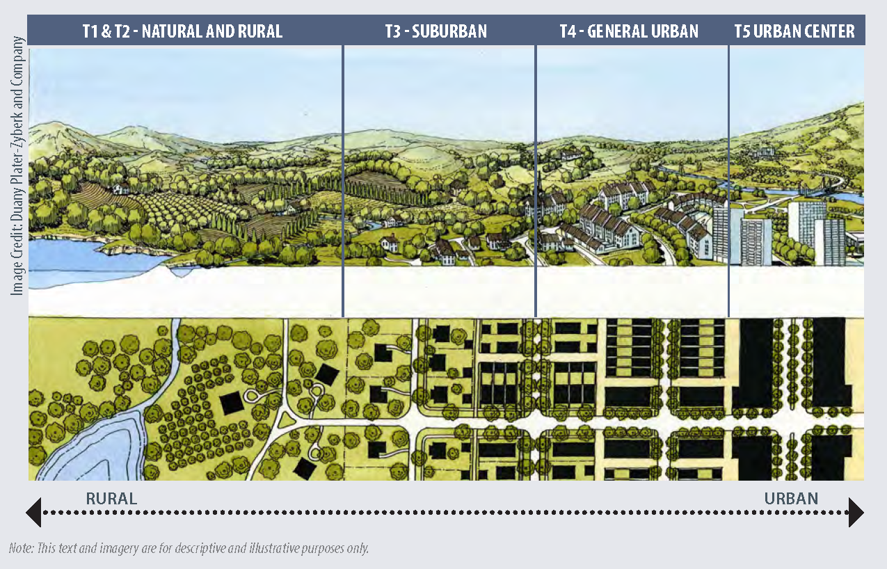
2.3.2 - SUMMARY OF TRANSECT-BASED DISTRICTS
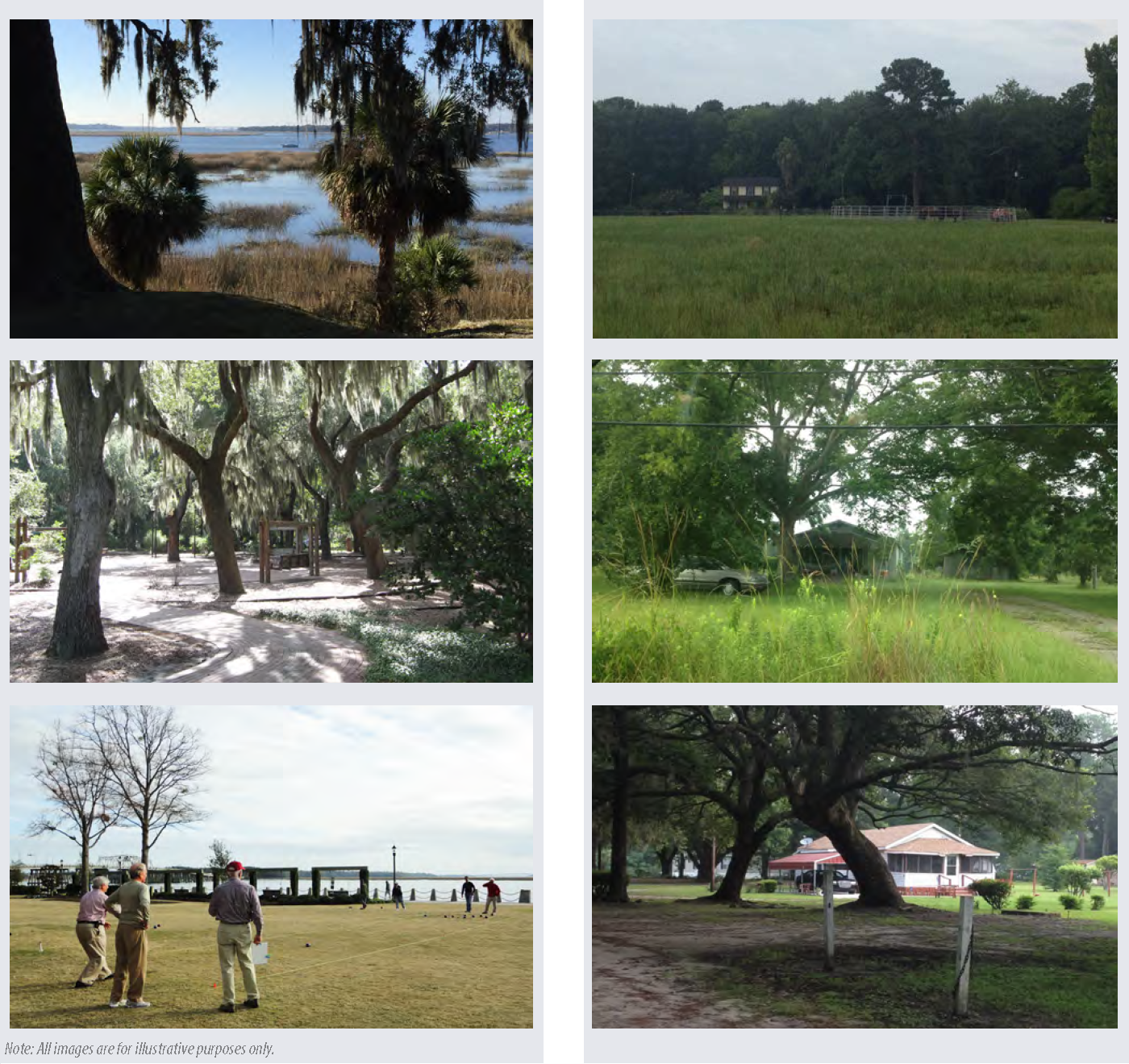
T1-NATURAL PRESERVE DISTRICT (T1)
The T1-Natural Preserve district is intended to preserve areas that contain sensitive
habitats, active or passive open spaces and urban parks, cemeteries, and limited agricultural
uses. This district typically does not contain buildings, with the exception of small
civic buildings, interpretive centers, or supportive recreation facilities. There
are no specific development standards listed for this district.
T2-RURAL DISTRICT (T2)
The T2-Rural district is made up of lands in an open, cultivated, or sparsely settled
state. Planning for future development within the City of Beaufort does not include
rural areas, and inclusion of the T2-Rural district here is for illustrative purposes
only. There are no development standards listed for this district.
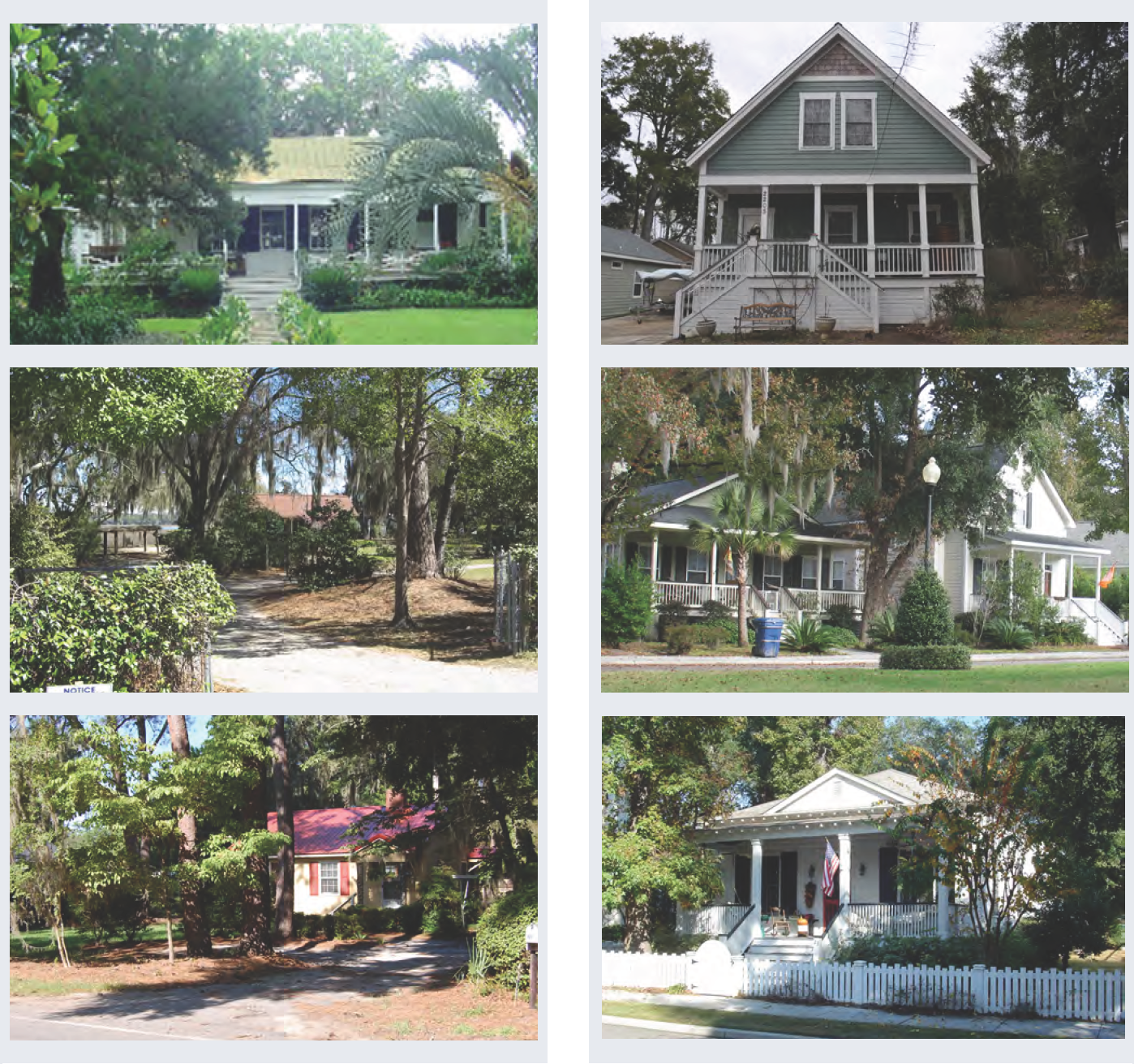
T3-SUBURBAN DISTRICT (T3-S)
T3-Suburban district is single-family residential in character, with less development
than other Transect-based districts within the city. While almost exclusively residential,
civic and park functions are also complementary to the character within this district.
T3-NEIGHBORHOOD DISTRICT (T3-N)
The T3-Neighborhood district is residential in character, and includes a mixture of
residential and civic uses. Residential units are an assortment of sizes and types
including cottages, small houses, two- and three-family dwellings, village houses,
and cottage courts. Carriage houses, located behind single family homes, and on the
interior of lots, may contain studios or other small businesses.
T4-HISTORIC NEIGHBORHOOD DISTRICT (T4-HN)
The T4-Historic Neighborhood district is a primarily residential district that encompasses
the entire historic district with the exception of a few north-south commercial corridors.
It contains houses and residential buildings that are characterized by generous front
porches, southern orientation, and historic architectural detailing. A limited number
of corner retail buildings historically existed, and continue to exist, in this district.
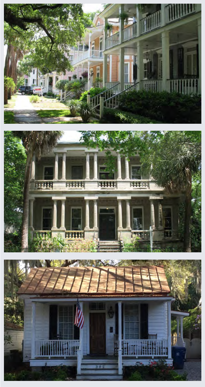
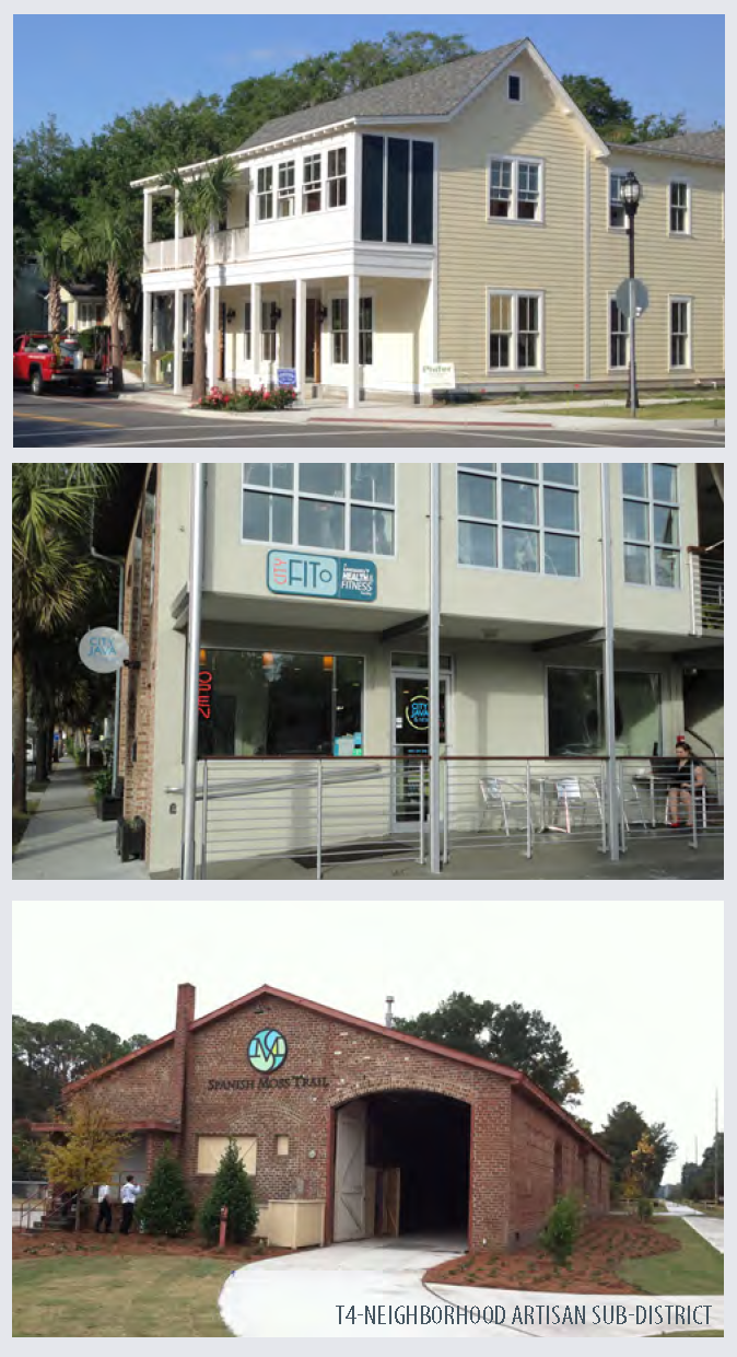
T4-NEIGHBORHOOD (T4-N)
The T4-Neighborhood district is a mixed-use zone of urban residential units and limited
commercial development. A wide range of building types exist in the T4-Neighborhood
district, including, but not limited to, apartment buildings, mixed-use buildings,
rowhomes, duplexes, corner stores, and both attached and detached single-family housing.
A sub-district of this is the T4-Neighborhood Artisan (T4-NA) district. It incorporates
more industrial uses, as well, and is applicable in the Depot Road area where industrial
uses abut residential areas.
T5-DOWNTOWN CORE DISTRICT (T5-DC)
The T5-Downtown Core district consists of higher density, mixed-use buildings that
accommodate retail, rowhomes, offices, and apartments. A tight network of streets,
including those in Beaufort's historic commercial downtown, allows this district to
be a highly walkable area. Buildings are set very close to the street in order to
define the public realm and allow for visible activity along the streetscape.
T5-URBAN CORRIDOR DISTRICT (T5-UC)
The T5-Urban Corridor district consists of higher density, mixed-use buildings that
accommodate retail, rowhomes, offices, and apartments located along primary thoroughfares.
A tight network of streets allows this district to be a highly walkable area. Buildings
are set very close to the street in order to define the public realm and allow for
visible activity along the streetscape.
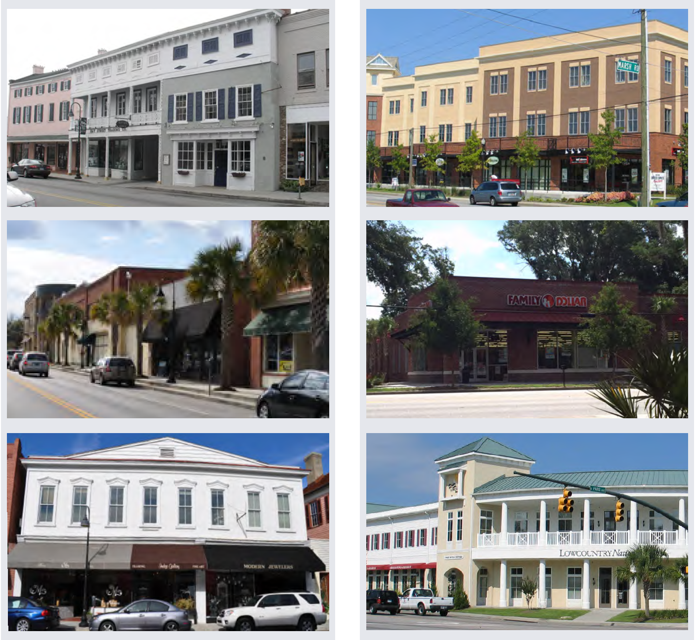
2.3.3 - SUMMARY OF CONVENTIONAL DISTRICTS
| REGIONAL MIXED-USE (RMX) The RMX district's intensity accommodates region- and community-serving commercial and business uses, as well as highway-oriented businesses. Development form supports a high-quality commercial character coordinated with a uniform streetscape that enables pedestrian and transit access. | 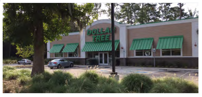 |
| LIGHT INDUSTRIAL DISTRICT (LI) The LI district permits office, manufacturing, industrial, and warehousing uses, as well as their supporting uses. Moderate to high intensities are permitted to achieve maximum land utilization that will also accommodate small businesses and start-up or incubator businesses. It also allows for larger industrial parks where appropriate. | 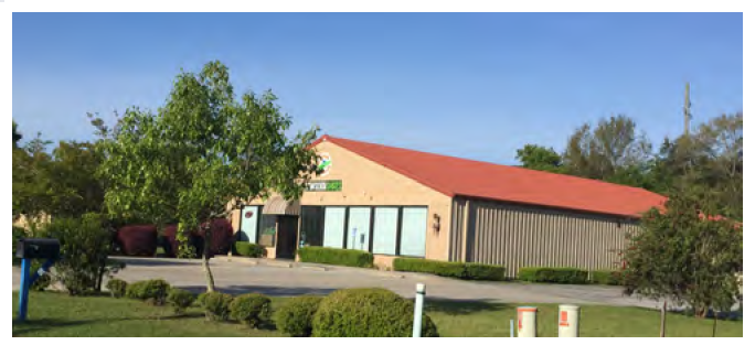 |
| INSTITUTIONAL & CAMPUS DISTRICT (IC) The IC district supports generally non-residential institutions and employment areas that are designed in a campus-like setting, such as hospitals, universities, research facilities, and offices. It is intended to ensure that these unique institutions are designed to be compatible with their surroundings and the rest of the city. |  |
| MANUFACTURED HOME PARK DISTRICT (MHP) The MHP district provides a sound and healthy residential environment that is sufficient to meet the needs of inhabitants living in manufactured homes, to protect manufactured home parks from encroachment by incompatible uses, and to encourage the consolidation of manufactured homes into manufactured home parks. | 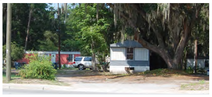 |
| MILITARY RESERVATION DISTRICT (MR) The MR district is applied to existing military bases and Department of Defense lands, and provides for military facilities and all supporting activities, such as housing, offices, and services that are on base land, even though they would otherwise be considered separate uses. Military property is under jurisdiction of the federal government. Recommendations and standards for this district are not included since these lands are federally owned, and are typically not subject to city regulations. | 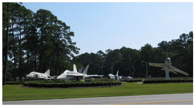 |
2.4.1 - TRANSECT-BASED DISTRICT STANDARDS
2.4.2 - CONVENTIONAL DISTRICT STANDARDS
General standards for development in the Regional Mixed-Use (RMX), Light Industrial (LI), Institutional & Campus (IC), and Manufactured Home Park (MH) districts are outlined in the table below. Land designated as Military Reservation (MR) district is under the jurisdiction of the federal government; the City has no development standards for these lands.
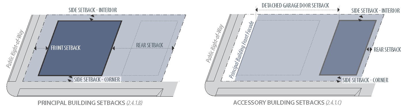
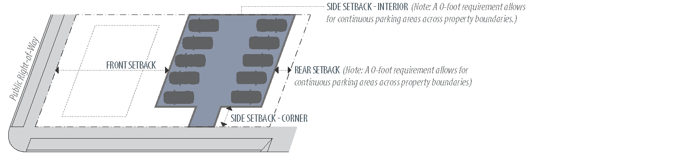
2.5.1 - BUILDING PLACEMENT AND ORIENTATION
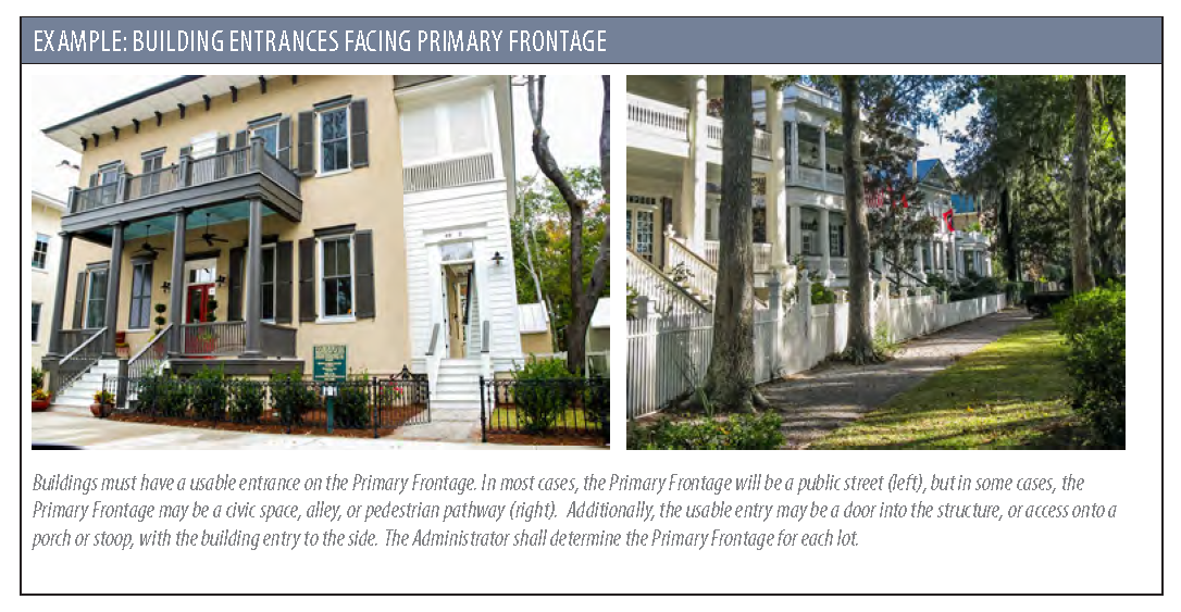
A.
Frontage and Orientation on Street: All buildings shall front a street right-of-way, and have a usable entrance on the Primary Frontage with the following conditions and exceptions:
1.
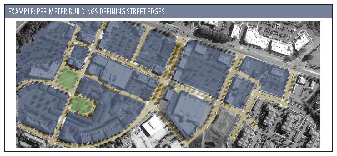
Multi-Building Sites:
a.
Buildings shall be located to break up the site into a series of smaller blocks defined by streets and pedestrian walkways, and to frame and enclose parking areas, outdoor dining areas, and/or gathering spaces for pedestrians between buildings.
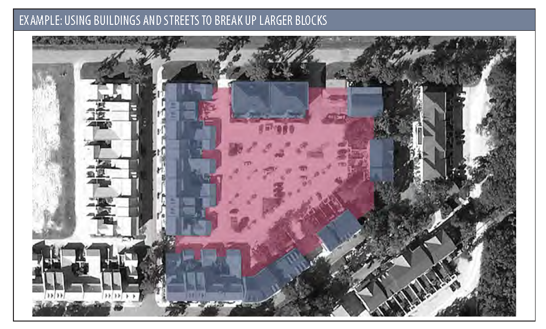
b.
Perimeter buildings and outparcels shall be configured and located to define street edges, development entry points, and spaces for gathering between buildings.
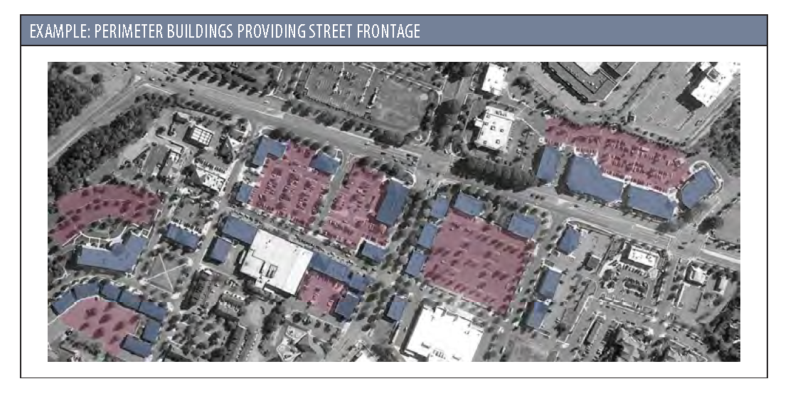
c.
Perimeter buildings shall be oriented so that the primary facade(s) faces a public street and has a usable entry on that street. Buildings that are interior to a lot that has buildings that otherwise meet the frontage requirement may have entrances that do not face the Primary Frontage.
2.
Live/Work Buildings: Where such buildings are permitted, the entrance to the commercial space shall face the Primary Frontage. However, the entrance to the residential space may be located on the side or rear.
3.
Utility and Conservation Lots: Lots platted for the sole purposes of being sites for public utilities (e.g., water, sewer, electric, stormwater) or as conservation areas shall not be required to abut a dedicated public street. Adequate access by easement shall be provided. Buildings associated with utilities shall meet the building standards and guidelines of the zoning district.
4.
Lots May Front on Civic or Open Space: Lots shall be permitted to front on a civic or open space as defined in Section 7.4.3.
B.
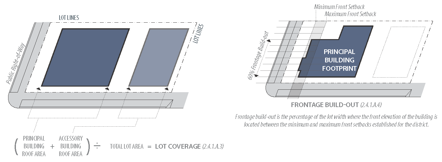
Frontage Build-Out:
1.
Facades shall be built parallel to the principal frontage line or to the tangent of a curved principal frontage line, and along a minimum percentage of the frontage width at the setback, as specified in Sections 2.4.1 A.4. and Section 4.4 (Private Frontage Type).
a.
Exceptions:
i.
Exceptions may be granted by the Administrator where the parcel has an irregular configuration, utility easements or legal constraints which prevent compliance, or if building is sited to take advantage of specific topographical and natural characteristics.
ii.
This provision does not apply in T3-S, IC or LI zoning districts.
2.
Front facades shall front public streets or rights-of-way. In the case where buildings front multiple streets, or desire to have entrances facing the parking lot, multiple front facades may be designed.
3.
For parcels that may contain multiple structures in different phases, an overall Illustrative Sketch, showing proposed building locations and site circulation, shall be prepared to ensure that the frontage build-out is being met as closely as possible. These parcels will not be required to be built out all at once, and may be phased over time. The Illustrative Sketch is subject to future modifications as long as the intent of this standard continues to be met—this will be evaluated by the Design Review Authority as each individual project phases are designed.
4.
Pedestrian-use areas (such as plazas, courtyards, and sidewalk cafes) within the minimum and maximum front setbacks are exempt from the frontage build-out when all of the following conditions are met:
a.
The existing sidewalk is less than 8' wide.
b.
The primary facade is within 10' of the build-to line.
c.
One of the appropriate frontage types (see Section 4.4) is utilized.
5.
Where rear access is not possible, driveways are also exempt from this requirement, and their width may be subtracted from the total lot width to determine the build-out percentage.
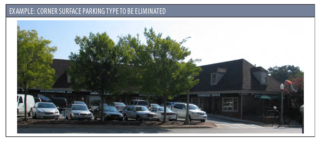
C.
Corner Lots:
1.
Buildings located at street intersections shall place the primary building, or part of the building, at the corner; however, gathering spaces may be appropriate at corners of larger developments.
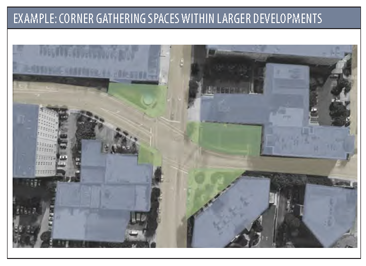
2.
Parking shall not be located between the building and the Primary Street(s).
D.
Pedestrian Entries from Frontage Line:
1.
Buildings shall have their principal pedestrian entrances on a frontage line.
2.
All buildings with shared entrances shall be oriented so that the primary entrance(s) face(s) the street.
3.
In the case of corner lots, the primary entrance(s) shall face the street from which the building derives its street address.
4.
In the T4 and T5 zones, blank facades are not permitted. Multiple pedestrian entrances for public access shall be provided every 50 feet, or more frequently. The Design Review Authority may modify the spacing of the entrances based on the amount of glazing, interior layout, and general design of the structure.
E.
Frontage Types: The private frontage of the building shall comply with the standards laid out in Section 4.4 (Private Frontage Type).
F.
Building Types: More specific standards may apply based on a specific building type (Section 4.5).
2.5.2 - INFILL LOT STANDARDS
A.
The minimum setbacks required may be reduced for infill lots where existing development on the block does not match the current standards in Section 2.4.1. Setbacks for such lots shall either match an existing adjacent setback or use the calculated average setback of the adjacent lots.
B.
Special Conditions:
1.
Islands of Beaufort neighborhood: Side Setback for T3-S is reduced to 10 feet.
2.
Battery Shores neighborhood: Side Setback for T3-S is reduced to 10 feet.
3.
Battery Point neighborhood: Rear Setback for T3-N is reduced to 10 feet.
4.
T3-N parcels between Fuller Parkway and Ribaut Road, bound by Stuart Street on the North and Barnwell Avenue on the south:
a.
For lots with frontage onto both Fuller Parkway and Ribaut Road, subdivision shall not add new driveways onto Ribaut Road. No new lot may be created without either:
i.
A new rear lane created to provide rear access to parcels fronting Ribaut Road; or
ii.
An access easement from Fuller Street.
2.5.3 - WATER-ORIENTED FACILITIES
Water-oriented facilities such as docks, marinas, boat houses, etc., shall be allowed to encroach into required setback areas along shorelines and into rivers, lakes, streams and other waterways. See Section 3.7.1 F. and 8.2 for more details on these structures and facilities.
2.5.4 - WATERFRONT LOTS
A.
Attached Garages: Notwithstanding the requirements for Attached Garages in Section 2.4.1 CB.6., such structures associated with residential dwellings may be placed in front of the principal building elevation, if all of the following conditions are met:
1.
The upper level(s) shall contain habitable space.
2.
The frontage requirement in Section 4.4 is met.
B.
Accessory Structures: Notwithstanding the requirements for Accessory Structures in Section 2.4.1 C.6., such structures associated with residential dwellings may be placed in front of the principal building elevation, if all of the following conditions are met:
1.
Structures shall meet the typical front and/or side setback requirements.
2.
Garage doors shall be oriented perpendicular to the public right-of-way to minimize visibility.
3.
Structures shall be compatible with the primary dwelling unit in architectural details including color, siding, roof pitch, window detailing, siding materials, roof materials and foundation.
C.
Critical Area Buffer: As required by Section 8.2.
D.
Special Lot Requirements:
1.
Specific to T3-S - Lot Width, Depth, and Area:
a.
The minimum lot width at the setback line for waterfront lots shall be 100 feet.
b.
The minimum lot depth for waterfront lots shall be 125 feet.
2.
Specific to T3-N: The front setback requirement for waterfront lots may be met with an accessory structure.
3.
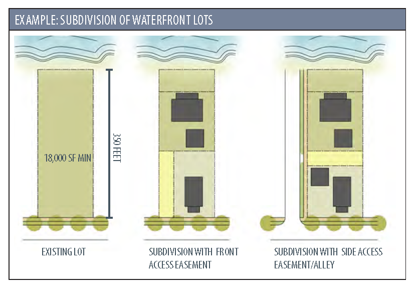
Subdivision of Waterfront Lots: Waterfront lots that exceed the minimum lot depth requirements, and are larger than 350 feet deep and 18,000 square feet, may be subdivided into two lots - one fronting the water and one fronting the right-of-way provided both lots conform with the applicable requirements of this Code. In such instances, the following standards apply:
a.
Lot Access: Access to the water-fronting lot shall be maintained through a minimum 20-foot access easement or right-of-way across the street-fronting lot. Alternatively, access may be provided via a side street, or an alley through the entire block. Access shall meet the minimum fire apparatus access road requirements as outlined in the International Fire Code.
b.
Lot Dimensions: The new lot(s) fronting the street shall meet the standards for T3-N.
2.5.5 - IRREGULAR LOT CONDITIONS
A.
Irregular Lot Lines: Generally, side lot lines shall be perpendicular or radial to the street right-of-way, and rear lines should be approximately parallel to fronting right-of-way lines. Irregularly shaped lots shall be permitted at the discretion of the Administrator when unique site conditions exist.
B.
Irregular Lot Setbacks: The location of required front, side, and rear yards (or setbacks) on irregularly shaped lots shall be determined by the Administrator, based on the prevailing spacing of buildings on the adjacent parcels. Where questions arise as to appropriateness, the applicant may be requested to provide additional design information.
C.
Double- and Triple-Frontage Lots: On lots with two street frontages, not located at a corner, or with three frontages and located at a corner, the front setback will apply to both the street that the building derives its address from, in addition to the opposite, parallel street. The setbacks for accessory structures will be reduced to half the front setback, however the provisions for garage doors in 2.4.1.C.6 still apply. This does not apply to lots located on a corner with a rear alley.
D.
Flag Lots:
1.
The front setback on flag lots shall be measured from the front property line within the main building site as opposed to the property line adjoining the public right-of-way.
2.
Flag lots may be permitted by the Metropolitan Planning Commission in major subdivisions as part of the subdivision review process, if the lot has an access strip with a minimum width of 20' serving the main building site of the property.
3.
Flag lots shall be permitted, using the process for Administrative Adjustment (Section 9.12), if all of the following conditions apply:
a.
Connectivity and circulation via a network of streets, alleys, pathways, etc. will be maintained.
b.
There is no reasonable alternative, due to extreme topographic conditions or other physical condition.
c.
The lot has an access strip with a minimum width of 20 feet serving the main building site of the property. The front setback on flag lots shall be measured from the front property line within the main building site, as opposed to the property line adjoining the public right-of-way.
d.
For waterfront lots, standards from Section 2.5.4 shall also be met.
4.
Flag lot access shall meet the minimum fire apparatus access road requirements as outlined in the International Fire Code.
2.5.6 - ENCROACHMENTS
The features listed below shall be permitted to encroach into a required yard or right-of-way, as applicable.
A.
Encroachments over Sidewalks: With approval of the City, county or SCDOT (whichever has authority over a street), awnings, arcades, canopies, and galleries (See Section 4.4), may encroach over the sidewalk to within 2 feet of the curb, but they shall provide a vertical clearance of at least 8 feet from any sidewalk.
B.
Upper Story Encroachments: Bay windows, balconies, and similar features projecting from the principal building may encroach up to 50% of the depth of the front and street side setback. With approval of the City, county or SCDOT (whichever has authority over a street), upper-story balconies or bay windows may encroach over the right-of-way a maximum of 3 feet, but they shall provide a vertical clearance of at least 8 feet from any sidewalk.
C.
Lower Story Encroachments: Cornices, eave overhangs, chimneys, flues, bay windows, and similar projections (including gutters) may encroach up to 2 feet into any required yard.
D.
Covered Porches: Covered porches may encroach a maximum of 8 feet into any required front yard or street side yard setback and to within 5 feet of any interior side or rear yard property line.
E.
Uncovered Porches, Decks, Patios, Steps and Stairs: Uncovered and unenclosed porches, decks, patios, steps and stairs, and other similar features may encroach to within 5 feet of any interior side and rear property line. Steps and stairs may encroach up to 100% of the depth of any required street yard setback, but may not encroach upon any public sidewalk.
F.
Walkways, and Driveways: Uncovered and unenclosed walkways, and driveways may encroach up to 100% of the depth of any required setback, unless a buffer, per Section 5.5.1, is required.
G.
Handicapped Ramps: Ramps for handicap accessibility and fire escapes that are required by the "Accessibility Code" may encroach into any required yard but may not be closer to any property line than 5 feet. Such features shall not be located in a front yard if it is possible to accommodate them in a side or rear yard.
H.
Fences and Garden Walls: Fences and garden/yard walls may encroach into required setbacks. The support structures for fences shall be located on the inside of the fence, and no fence, wall or hedge shall exceed the following dimensions:
1.
Front or Street Side Setback: Four feet in height, with the following exceptions:
a.
On T3 lots that front Ribaut Road, fences may be permitted to be 7 feet in height on the condition that such fences are set back from the front property line 1 foot for every 1 foot increase in height above 4 feet.
b.
In the LI District, parcels fronting a Primary Street may have fences or walls up to 6 feet in height. Parcels fronting all other streets may be up to 10 feet in height.
c.
Electric fences are not permitted to encroach into any front or street side setbacks.
2.
Interior Side or Rear Setback of a Transect-Based District: 6 feet in height.
3.
Interior Side or Rear Setback of a Conventional District: 8 feet in height.
4.
Interior Side or Rear Setback of LI District: 10 feet in height.
I.
Mailboxes: Mailboxes may encroach into a front setback area. The following standards apply:
1.
In the Historic District, freestanding mailboxes are not permitted. Mailboxes shall be attached to a fence or the structure itself.
2.
When grouped or ganged mailboxes are required as part of a new development, a structure shall be provided to house the individual units. The structure may encroach into a typical front or side setback. The structure shall be included in the site plan and the design shall be approved by the appropriate Design Review Body.
2.5.7 - STREET ACCESS STANDARDS
A.
Access to Lots from Alleys/Rear Lanes:
1.
Lots served by alleys shall access garages and/or off-street parking areas from the alley, and shall not have driveways in front or corner side yard areas.
2.
Requirements for alley locations can be found in Section 7.2.3.
B.
Avoid Double-Frontage and Reverse-Frontage Lots:
1.
New double-frontage and/or reverse-frontage lots (lots with street frontage on opposite sides of the lot) are prohibited. The Design Review Authority may permit them on a case-by-cases basis if they are unavoidable due to existing topographical or environmental conditions.
2.
To encourage the subdivision of existing double-frontage residential lots into two single-frontage residential lots, the minimum lot size for such lots may be reduced to 75% of the minimum lot size for the district, as established in Section 2.4.
2.5.8 - EXCEPTIONS TO SECTION 2.4.1 E.—PARKING LOCATION
A.
The provisions shall not apply to cars parked on front-loaded driveways.
B.
Where lot depth is less than 60' deep, the Administrator shall evaluate this requirement on a case-by-case basis. In no case shall parking be located in front of a building in T4 and T5 zoning districts.
C.
Where lots have frontage on more than one Primary Street and build-out on one of the streets is planned to be phased, per Section 2.5.1 B.3., parking may be permitted within the parking setback, provided it doesn't prevent or preclude future build-out of the overall master plan for the parcel. Screening is still required per Section 5.7.8.
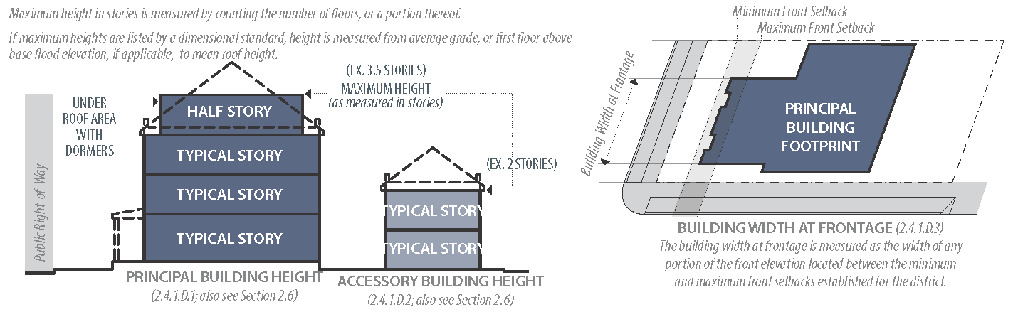
2.6.1 - MEASUREMENT OF BUILDING HEIGHT
A.
Building height is measured as the number of stories (syn. floors) in a building. A story is a habitable level in a building of no more than 15 feet in height from finished floor to finished ceiling.
B.
Where a maximum height is also provided in feet, that height shall be taken from the average sidewalk or site grade at the front facade of the building to the mean roof height or top of the parapet. Where the building is located in a flood zone, the height shall be taken from the first finished floor above the base flood elevation.
C.
Under-roof areas with dormers shall be counted as half-stories.
D.
Mezzanines shall be counted as stories, unless they are within a floor-to-ceiling volume that is no more than 15 feet in height.
E.
Unoccupied attics less than 7 feet in height to the ridge beam or collar tie (whichever is lower) and raised basements less than 6 feet above the adjacent grade shall not be calculated as stories.
F.
Certain buildings (such as gymnasiums, religious institutions, theatres, etc.) may require finished floor-to-ceiling heights greater than 15 feet. In such instances, the number of stories shall be calculated as the finished floor-to-ceiling height (in feet) divided by 15. Any fractions of a story shall be rounded up to the next whole number, with the following exception:
1.
Specific to T5-UC: The maximum first floor height for such buildings shall be 24'.
G.
Specific to T5-DC: The maximum height at the property line shall be 3 stories, and the maximum height 15 feet behind the property line, or front line of the building, shall be 4 stories.
2.6.2 - BUILDING HEIGHT ABOVE GRADE
A.
General to All Zones:
1.
Freeboard: In addition to the standards listed below, where a parcel is located in a flood-hazard zone, the minimum elevation above grade is 1 foot above base flood elevation.
2.
Exception: Commercial buildings that have been floodproofed, per ASCE Section 24 or most recent version, do not have to be elevated above grade.
B.
Specific to T3 Zones:
1.
If the finished floor of new single-family residential construction will be lower than the average grade along any property line, the finished floor must be elevated a minimum of 18" above finished grade adjacent to the building exterior.
2.
The finished ground floor elevation for 2- and 3-unit buildings shall be elevated a minimum of 2 feet above the average adjacent sidewalk, or adjacent street grade where no sidewalk is present.
3.
If a single-family residence in a T3 zone is developed as part of an Alternative Development Pattern (Section 2.8), it shall be elevated a minimum of 18" above the average adjacent sidewalk grade or adjacent street grade where no sidewalk is present.
C.
Specific to T4 Zones:
1.
The finished ground floor height for residential structures shall be elevated a minimum of 2 feet above the average adjacent sidewalk grade or adjacent street grade where no sidewalk is present. Apartment Houses are permitted to be a minimum of 18" above grade, per Section 4.5.7.
2.
The ground floor height of single-family residential structures shall be a minimum of 9 feet from finished floor to ceiling.
3.
The ground floor height of multi-family residential structures shall be a minimum of 10 feet from finished floor to ceiling.
4.
The ground floor height of commercial buildings shall be a minimum of 11 feet from finished floor to ceiling.
5.
Each full story above the ground floor shall be a minimum of 8 feet from floor to ceiling.
D.
Specific to T5 Zones:
1.
The finished ground floor height for residential structures shall be elevated a minimum of 3 feet above the average adjacent sidewalk grade. Apartment Houses are permitted to be a minimum of 18" above grade, per Section 4.5.7.
2.
The ground floor height of residential structures shall be a minimum of 10 feet from finished floor to ceiling.
3.
The ground floor height of single-story commercial buildings shall be a minimum of 14 feet from finished floor to ceiling.
4.
The ground floor height of multi-story commercial buildings shall be a minimum of 12 feet from finished floor to ceiling.
5.
In T5-DC, the Historic Review Board may permit deviations from the minimum height requirements listed above if doing so would allow a structure to be more compatible with the surrounding context.
6.
Each full story above the ground floor shall be a minimum of 8 feet from floor to ceiling.
2.6.3 - TWO-STORY HEIGHT REQUIREMENTS
Specific to Zones T4-N and T5-UC: Two-story buildings are required within 250 feet of any Significant Intersection (see Street Hierarchy Diagram in Appendix C.3) as measured from the centerline of the intersection. Any parcel that is partially within the 250-foot radius will be required to comply with the two-story height requirements.
Where a two-story minimum building height is required, the following configurations are permitted in addition to a typical two-story building with habitable space on each level:
A.
Two-Story Mass: This can be an open, double-height structure with a minimum building height of 24 feet. The second floor does not need to be built out or habitable.
B.
Mezzanine: The intent of mezzanines is to provide upper-level activity along street facades. Mezzanines shall meet the following conditions:
1.
All buildings shall include a minimum massing of two stories extending fully along all street-fronting facades and any facade that is visible from a corner. If a building cannot meet this standard through the use of a mezzanine, then the mezzanine will not be permitted to fulfill the two-story requirement.
2.
Mezzanines shall be located on the Primary Facade(s) of a building.
3.
A mezzanine shall be designed as usable primary interior floor space, not storage or other secondary, mechanical, or service functions.
4.
All mezzanine floor space shall be located in direct contact with street-fronting second-floor windows and is required to meet all of the window transparency requirements of a second floor.
5.
When being used to satisfy a two-story building height requirement, a mezzanine level shall meet all ceiling height standards of a second floor.
2.6.4 - DIMENSIONAL HEIGHT STANDARDS
Height requirements for signs, lighting, landscape screens, and all other structures or objects for which a dimensional height requirement is established by this Code shall be measured as the vertical distance from the average sidewalk or site grade at the structure or object's foundation to its highest point.
2.6.5 - ITEMS NOT INCLUDED IN HEIGHT CALCULATIONS
The height limitations of this Code shall not apply to church spires, belfries, cupolas and domes not intended for human occupancy, monuments, water towers, mechanical penthouses (provided they are set back 20 feet from the front elevation), observation towers, transmission towers, chimneys, smokestacks, conveyors, flagpoles, masts and antennas (provided evidence from appropriate authorities is submitted to the effect that such building or buildings will not interfere with any airport zones or flight patterns). The Design Review Authority may adjust the 20-foot setback on a case-by-case basis.
2.7.1 - BEAUFORT HISTORIC DISTRICT (HD) OVERLAY
A.
Purpose: The purpose of the Beaufort Historic District is to promote the educational, cultural, and general welfare of the public through the preservation, protection, and enhancement of the old, historic or architecturally significant structures and areas of the City and to maintain such structures and areas as visible reminders of the history and cultural heritage of the City, the state, and the nation. The Historic District is a pedestrian-oriented area.
B.
Applicability: Properties within the Beaufort Historic District are subject to specific standards found in this section, and to the review procedures of the Historic District Review Board as described in Section 10.7.
C.
Beaufort Historic District Designated: For the purpose of this section, the Beaufort Historic District is hereby established. The boundaries of this district shall be designated on the official Zoning Map of the City of Beaufort. The boundaries of the Beaufort Historic District and the Beaufort National Historic Landmark District are the same with the following clarifications/exceptions:
1.
Where boundaries are designated at specific roads, the centerlines of the rights-of-way of those roads shall be deemed said boundaries.
2.
The east and south boundaries of the district are established at the Beaufort River. These boundaries are established at the parcel lines, seawalls, or at mean high water mark, whichever extends further from the high ground.
3.
Structures attached to the high ground are deemed to lie within the district and shall be reviewed in entirety in accordance with the provisions of this section.
D.
Subdistricts Established: The Beaufort Historic District shall be composed of 2 subdistricts identified as the Beaufort Preservation Neighborhood (BPN) and the Beaufort Conservation Neighborhood (BCN). There may be established one or more of each subdistrict within the Beaufort Historic District, provided that all such districts shall consist of at least five acres of contiguous land. The boundaries of these subdistricts shall be designated on the official Zoning Map of the City of Beaufort. Where the term Beaufort Historic District (or a similar reference, such as "historic district") is used in this section or in any supplementary materials, it shall apply to both subdistricts. However, where there is a specific reference to a subdistrict, that specific reference shall apply and supersede any reference to the Beaufort Historic District.
E.
Trash and Recycling Screening: All private trash and recycling receptacles shall be hidden or screened from view. Unscreened facilities shall come into compliance with the provisions of this section within 18 months of adoption of this Code.
F.
Exemptions:
1.
The Bladen Street Redevelopment District overlay zone is exempted from Historic District Overlay standards (See Section 2.7.3 F.).
2.
Routine maintenance and repair of any of the existing features of a structure that does not involve a change in design, type of materials, or outward appearance shall be exempt from the review and approval requirements of this section.
2.7.2 - RETAIL FRONTAGE OVERLAY
A.
Purpose and Intent: In certain districts, it is desirable to maintain a residential character while permitting mixed uses to occur in buildings that front designated streets.
B.
Certain Commercial Permitted: Where a block face is designated on the Zoning Map as a retail frontage overlay, the building with direct access to the designated fronting street is permitted to be occupied by certain additional commercial uses, as indicated in the Table of Permitted Uses in Section 3.2.
C.
Designation: Retail frontage overlays are designated on the Zoning Map by a dashed line, as indicated in the map key.
2.7.3 - REDEVELOPMENT DISTRICT OVERLAYS
A.
Purpose and Intent: The City hereby finds that it is necessary to create certain districts to encourage redevelopment in specific areas. These districts are based upon traditional standards for City buildings, derived from the existing conditions in the City and from a number of sources in planning literature - See Appendix B.1.1.
B.
Applicability: All parcels designated "redevelopment district" as indicated on the Zoning Map shall be subject to these provisions.
C.
Application of Standards: The majority of standards for the existing Redevelopment Districts - Boundary Street and Bladen Street - have been incorporated into the body of the Code. However, where special standards apply for the district, they are listed in this section. In the case of conflict between the standards set forth in the redevelopment districts and any other local land development regulation, these standards shall apply.
D.
Administration: Interpretation of all standards in the redevelopment districts - both architectural and streetscape standards - shall be the responsibility of the Administrator (syn. City Architect). See Section 9.8.2 5.b. for the approval and appeal processes.
E.
Parking Requirements:
1.
Parcels ½ acre and smaller: There are no parking requirements.
2.
Parcels greater than ½ acre: one parking space for every 1,000 square feet of leasable or saleable building area is required.
3.
Location: These parking spaces may be located either on-site, on-street (along property frontage and/or directly across the street), in shared parking situations, or in any public parking facility, the closest outside edge of which facility is located no more than 500 feet from the entry to the proposed building. Documentation establishing the legal right for the applicant to use or share parking spaces shall be provided.
4.
Parking Stall Sizes: Head-in or diagonal spaces shall be a minimum of 9 feet x 18 feet. Parallel parking spaces shall be a minimum of 7 feet x 20 feet.
5.
Drive Aisle Widths: Drive aisles in parking lots shall be 22 feet wide for two-way circulation and to provide adequate backup space for 90-degree head-in parking. Diagonal parking and parallel parking spaces may be accessed with one-way, 10 foot wide drive aisles. All parking lot dimensions are at the discretion of the Fire Marshal, based on evaluation of adequate fire apparatus access and industry-approved standard.
F.
Specific to the Bladen Street Redevelopment District:
1.
Application of Standards:
a.
Redevelopment District is Exempted from Historic Overlay Standards: Construction of new structures and renovation or expansion of existing non-contributing structures not listed on the most recent "Above-Ground Survey of Historic Resources" within a designated redevelopment district shall be exempt from the standards of the historic overlay.
b.
Historic Structures: Demolition, renovation, or expansion of structures that are listed as "contributing" on the most recent "Above-Ground Survey of Historic Resources" shall be subject to approval by the HRB in accordance with Section 9.10.
2.
Exceptions to Section 3.2 Table of Permitted Uses: Inns and Hotels are permitted by-right in this redevelopment district, and are not subject to the conditions in 3.6.2.C.3.
3.
Street Hierarchy: The hierarchy of streets in this district is as follows, from highest to lowest: Bladen Street, North Street, Duke Street, Prince Street, Adventure Street. Bladen Street is the most important street in the redevelopment district.
4.
Master Plan: See Appendix B.2.3 for the original Bladen Street Master Plan.
G.
Specific to the Boundary Street Redevelopment District:
1.
Existing Planned Unit Developments: For existing City-approved planned unit developments (PUD) in the district, the PUD shall apply through February 6, 2032, a period of up to 25 years from the date of adoption of the Boundary Street Redevelopment District. Once 25 years pass, said PUDs are no longer applicable and shall then fall under the regulations of the Boundary Street Redevelopment District and underlying zoning.
2.
Existing Buildings: With respect to existing buildings within the Redevelopment District, their use may be maintained despite changes made to allowable uses. In the event the building undergoes either structural or cosmetic modifications, if the cost of improvements exceeds 50% of the Fair Market Value of the building, it will be subject to the standards set forth by this code. This does not include repairs to a building, provided that the configuration is not modified or altered during the repairs. The Administrator (syn. City Architect) will have final jurisdiction over this matter. Signs not conforming to the requirements of this section shall be altered, removed, or otherwise brought into compliance with the requirements of this section at the time that the required building improvements are made.
3.
Specific Standards:
a.
Exceptions to Section 3.2 Table of Permitted Uses: Single-family detached uses are permitted regardless of the zoning district, except along Boundary Street and Robert Smalls Parkway. They are subject to all development standards laid out in this Code.
b.
Streets: All applications for development in the Boundary Street Redevelopment District shall include the design of street elements adjacent to the applicant's property. These designs shall be according to the street type adjacent to the property, as identified in the Street Regulating Plan (Appendix C). The street type and the appropriate thoroughfare sections inform the applicant regarding how parking, sidewalk, tree plantings and other elements are to be sized and arranged. Contact with the City architect will provide clarification about the required design for each street. All streets and alleys shall connect to other streets. Cul-de-sacs and T-turnarounds are not permitted.
i.
Street Hierarchy: The hierarchy of streets/street types in this district is as follows, from highest to lowest: Boundary Street (US 21), Ribaut Road, Robert Smalls Parkway (SC 170), Parallel Street, Edge Drive, Main Street, Park Street, Neighborhood Street, House Street. This hierarchy serves as an informal phasing and prioritization plan.
ii.
Construction of New Streets: See Section 7.2.1 D.
c.
Alleys: Alleys are required in the Boundary Street Redevelopment District to minimize curb cuts and to provide access to parking and service areas behind buildings. Alley requirements may be waived by the City architect for access to detached single-family residential lots greater than 45 feet in width in situations in which proper street front orientation, pedestrian circulation, and parking can still be accomplished. Alley locations and dimensions are not fixed but shall be designed to accommodate the alley's purpose. Alleys may be incorporated into parking lots as drive aisles and fire lanes. Recommended sections for alleys are included in Appendix C.
4.
Master Plan: See Appendix B.3.2 for the Boundary Street Illustrative Master Plan.
2.7.4 - AIR INSTALLATION COMPATIBILITY USE ZONE (AICUZ) OVERLAY DISTRICT STANDARDS
A.
Purpose: The Air Installation Compatibility Use Zone (AICUZ) District shall overlay other zoning districts. The AICUZ District includes all lands within an established footprint affected by airport operations at the Marine Corps Air Station Beaufort (MCAS Beaufort). The footprint includes all lands underlying the noise zones of 65 DNL (day-night average sound level) and greater, and accident potential zones shown on the 2013 AICUZ Accident Potential Zones and/or Noise Zones Map associated with the F-35B, on file at the City of Beaufort Department of Planning and Development Services. Properties within Noise Zone 1 are exempt from the requirements of this section. In order to increase public awareness, and to ensure the general safety and welfare of persons affected by adverse impacts common to military aircraft operations, Section E. of this ordinance requires that property owners within the AICUZ District be properly notified of their location. In addition, Section 2.7.4 K. sets forth limitations and restrictions that shall apply to certain land uses that have been determined to be incompatible according to federal standards.
B.
Obstruction Height Zones: There are hereby created and established certain zones that include all of the land lying beneath the primary, clear zone, approach clearance, inner horizontal, conical, outer horizontal, and transitional surfaces as they apply to MCAS Beaufort. An area located in more than one of the described zones is considered to be only in the zone with the more restrictive height limitation. The various zones are hereby established and defined as follows:
(1)
Outside of the zones established in Section 2.7.4 B., no object or structure will be permitted within the City whose height would:
(a)
Exceed 500 feet above ground level at its site.
(b)
cause an existing MDA, MOCA, MVA, or a decision height to be raised. (Note: minimum descent altitude (MDA) is the lowest AMSL altitude to which descent is authorized on final approach or during circling-to land maneuvering in execution of a standard instrument approach procedure (SIAP) where electronic glide slope is not provided. Minimum obstruction clearance altitude (MOCA) is the lowest published altitude between radio fixes on federal VOR airways, off-airway routes, or route segments that meets obstruction clearance requirements for the entire route segment and assures acceptable navigational signal coverage only within 22 miles of a VOR. Minimum vectoring altitude (MVA) is the lowest AMSL altitude at which aircraft operating on Instrument Flight Rules (IFR) will be vectored by a radar controller, except when otherwise authorized for radar approaches, departures, or missed approaches).
(c)
impose either the establishment of restrictive minimum climb gradients or nonstandard take-off weather minimums for any runway at MCAS Beaufort.
C.
Accident Potential Zones (APZ): APZs are divided into three types along primary flight paths:
•
The "clear zone" (CZ) is an area at either end of a runway that possesses a high potential for accidents.
•
APZ-1 is the area normally beyond the CZ, which possesses a significant potential for accidents.
•
APZ-2 is an area normally beyond APZ-1, which has a measurable potential for accidents. APZs are shown on the 2013 AICUZ Accident Potential Zones and/or Noise Zones Map associated with the F-35B, on file at the City of Beaufort Department of Planning and Development Services.
D.
Noise Zones:
1.
Definition: The noise exposure from aircraft operations is measured using the day-night average sound level noise metric (DNL). The DNL averages aircraft sound levels over a 24-hour period with an adjustment for increased sensitivity to nighttime noise. The DNL visually is depicted as a noise contour that connects points of equal value. The area between two noise contours is known as a "noise zone". Noise zones are hereby established as follows:
Noise zones are shown on the 2013 AICUZ Accident Potential Zones and/or Noise Zones Map associated with the F-35B, on file at the City of Beaufort Department of Planning and Development Services. Noise Zone 1 covers that portion of the City that lies outside of the Air Installation Compatible Use Zone. As indicated in Section 2.7.4 A., properties within Noise Zone 1 are exempt from the requirements of this section.
2.
Residential Construction Restrictions: Aside from the residential construction restrictions imposed by this overlay, more stringent requirements of the base zoning district may also apply. For the purposes of this section, "gross density" means the total number of dwelling units (which include any building or portion thereof used as a place of residence, such as single-family dwellings, multi-family dwellings, commercial apartments, live/work units, garage apartments, accessory dwelling units, etc.) on a site divided by the entire site area.
a.
Residential development is not permitted in a Clear Zone.
b.
Single-family residential development within Accident Potential Zone (APZ 1 and APZ 2) and/or within Noise Zone 3 (DNL 75 and above) may not exceed a gross density of one (1) dwelling unit per three (3) acres.
c.
Residential development within Noise Zone 2b (DNL 70 to 75) may not exceed a gross density of one (1) dwelling unit per acre.
d.
Residential development within Noise Zone 2a (DNL 65 to 70) may not exceed a gross density of two (2) dwelling units per acre. 2.7.4
E.
Notification:
1.
At all real estate closings involving a property in an APZ or noise zone as depicted on the 2013 AICUZ Accident Potential Zones and/or Noise Zones Map associated with the F-35B, on file at the City of Beaufort Department of Planning and Development Services, the buyer, seller, and witnesses shall sign the following AICUZ disclosure form which shall be filed with the deed and/or plat at the Beaufort County Register of Deeds Office. Property owners may contact the City of Beaufort Department of Planning and Development Services to obtain information concerning a property's designation on the AICUZ Maps.
Air Installation Compatible Use Zone Disclosure Form
The property at _______ (address/location) is located in proximity to the Marine Corps Air Station Beaufort. The City of Beaufort has determined that persons on the premises will be exposed to accident potentials and/or significant noise levels as a result of the airport operations. The City has established certain noise zones and accident potential zones (APZs).
Pursuant to the 2013 AICUZ Accident Potential Zones and/or Noise Zones Map associated with the F-35B, the above property is located in:
Noise Zone (2a, 2b, or 3) _______ and
Accident Potential Zone (CZ, APZ-1, or APZ-2) _______.
The City has placed certain restrictions on the development and use of property within these areas. Before purchasing the above property, you should consult the Administrator to determine the restrictions that have been placed on the subject property.
CERTIFICATION
As the owner of the subject property, I hereby certify that I have informed _______, as a prospective purchaser, that the subject property is located in an Air Installation Compatibility Use Zone District.
Dated this _______ day of _______, _______.
Witness_______Owner_______
As a prospective purchaser of the subject property, I hereby certify that I have been informed that the subject property is in an Air Installation Compatible Use Zone District, and I have consulted the Administrator to determine the restrictions which have been placed on the subject property.
Dated this _______ day of _______, _______.
Witness_______Purchaser_______
2.
All prospective renters signing a commercial or residential lease shall be notified by the property owner through a written provision contained in the lease agreement if the leased property is located within the AICUZ District.
3.
All subdivision plats, planned unit development plats, rowhome plats and /or condominium documents in the AICUZ District shall contain the following Acknowledgement:
Air Installation Compatible Use Zone Disclosure Statement
This property lies in an Air Installation Compatible Use Zone District, which applies to property in proximity to the Marine Corps Air Station Beaufort. The City of Beaufort has determined that persons on the premises will be exposed to accident potentials and/or significant noise levels as a result of the military operations. Future purchasers and lessors of this property or portions thereof will be required to sign a disclosure form per the City of Beaufort Planning Department and file the form with the deed and/or plat at the Beaufort County Register of Deeds Office (RMC Office). All or a portion of this property lies within:
Pursuant to the 2013 AICUZ Accident Potential Zones and/or Noise Zones Map associated with the F-35B, all or a portion of this property lies within:
Noise Zone (2a, 2b, or 3): _______, which has an associated DNL (Day-Night Average Sound Level) of: _______
Accident Potential Zone (CZ, APZ-1, or APZ-2): _______
In the case of new construction, a signed AICUZ Acknowledgement shall accompany the building permit application.
1 A definition of each listed use type is in Article 13 (Definitions).
2 Similar uses, and any other retail business or service establishment permitted or conditionally permitted as determined by the Administrator, shall be of the same general character as the listed uses.
3 See Section 2.7.4 D.2. for complete information on Residential Construction Restrictions based on specific Noise Zones.
F.
Notice to Military Installations:
1.
S.C. Code 1976 § 6-29-1610, as amended, sets forth notice requirements pertaining to federal military installations. The provisions of this subsection shall apply to the following types of land use and zoning decisions when such decisions involve land located within an Accident Potential Zone or Noise Zone, pursuant to the 2013 AICUZ Accident Potential Zones and/or Noise Zones Map associated with the F-35B:
a.
Adoption of or amendment to the City of Beaufort Comprehensive Plan;
b.
An appeal to the City of Beaufort Zoning Board of Appeals (ZBOA);
c.
A request to the ZBOA for a variance from the provisions of City of Beaufort Unified Development Ordinance; or
d.
A request to the ZBOA for approval of a Special Exception Use.
(Ord. No. O-19-17, (Att.), 7-25-2017)
2.7.5 - BEAUFORT COUNTY AIRPORT OVERLAY DISTRICT STANDARDS
A.
Description: The Airport has one runway designated as Runway 7/25. The runway accommodates aircraft over 12,500 pounds and is therefore classified as "other than utility runway." Since aircraft can land in either direction, non-precision-instrument approaches with visibility minimums greater than three-fourths of a statute mile have been approved and published by the FAA for both ends of Runway 7/25 at the Airport. These classifications are current as of October 2006. The following prescribes the airport height zones and limitations for Beaufort County Airport as dictated by Title 14 Code of Federal Regulations Part 77. A property located in more than one of the described zones is considered to be in only one zone with the more restrictive height limitation.
B.
Airport Overlay Zones:
1.
Primary Zone: This is an area longitudinally centered on a runway, extending 200 feet beyond each end of that runway with the width so specified for each runway for the most precise approach existing or planned for either end of the runway. The width of the primary zone is as follows: 500 feet for non-precision instrument runways having visibility minimum greater than three-fourths of a statute mile.
2.
Horizontal Zone: This is the area around a civil airport with an outer boundary perimeter of which is constructed by swinging arcs of specified radii from the center of each end of the primary zone of each airport's runway and connecting the adjacent arcs by line tangent to the arcs. The radius of the arc specified for each end of a runway will have the same arithmetical value. That value will be the highest composite value determined for either end of the runway. The radius of each arc is:
a.
Runway 7 End: Ten thousand feet for non-precision instrument runways having visibility minimum greater than three-fourths of a statute mile.
b.
Runway 25 End: Ten thousand feet for non-precision-instrument runways having visibility minimum greater than three-fourths of a statute mile.
3.
Conical Zone: This is the area extending outward from the periphery of the horizontal zone for a distance of 4,000 feet.
4.
Approach Zone: This is an area longitudinally centered on the extended runway centerline and extending outward from each end of the primary surface. An approach zone is designed for each runway end based upon the type of approach available or planned for that runway end.
a.
The inner edge of the approach zone is the same width as the primary zone (i.e., 500 feet) and it expands uniformly to a width of:
i.
Runway 7 End: Three thousand five hundred feet for non-precision instrument runways having visibility minimum greater than three-fourths of a statute mile.
ii.
Runway 25 End: Three thousand five hundred feet for non-precision instrument runways having visibility minimum greater than three-fourths of a statute mile.
b.
The outer width of an approach zone to an end of a runway will be that width prescribed in this Subsection for the most precise approach existing or planned for that runway end.
c.
The approach surface extends for a horizontal distance of:
i.
Runway 7 End: Ten thousand feet for all non-precision-instrument runways other than utility.
ii.
Runway 25 End: Ten thousand feet for all non-precision-instrument runways other than utility.
5.
Transitional Zone: This is the area extending outward from the sides of the primary zones and approach zones connecting them to the horizontal zone. Height limits within the transitional zone are the same as the primary zone or approach zone at the boundary line where it adjoins and increases at a rate of one foot vertically for every seven feet horizontally, with the horizontal distance measured at right angles to the runway centerline and extended centerline, until the height matches the height of the horizontal zone or conical zone or for a horizontal distance of 2,000 feet from the side of the part of a precision approach zone that extends beyond the conical zone.
C.
Use Limitations: The following special requirements shall apply to uses within the Airport Overlay that are allowed in the base zone:
1.
Lights or illumination used in conjunction with streets, parking, signs or use of land and structures shall be arranged and operated in such a manner that is not misleading or dangerous to aircraft operating from the airport or in the vicinity thereof as determined by the airport operator.
2.
No operations of any type shall produce smoke, glare or other visual hazards within three miles of a usable runway.
3.
No operations of any type shall produce electronic interference with navigation signals or radio communication between the airport and the aircraft.
4.
No use of land shall be permitted which encourages large concentrations of birds, waterfowl or other wildlife within the vicinity of the airport.
D.
Official Map: The airport height zones defined in Section A. are shown on the map entitled "Beaufort County Airport Overlay District" which is incorporated herein by reference.
E.
Notification: At all real estate closings involving a property in the approach zone or transitional zone, the buyer, seller and witnesses shall sign the following form, which shall be filed with the deed and/or plat at the Beaufort County Register of Deeds Office.
Airport Overlay Disclosure Form
(For Properties within the Approach Zone or Transitional Zone of the Beaufort County Airport Overlay District)
The property at _______ (address/location) is located within the _______ Zone of the Airport Overlay District for the Beaufort County Airport (73J). Beaufort County has determined that persons on the premises may be exposed to noise and accident potentials from aircraft over flight as a result of airport operations.
The County has placed certain height restrictions on this property for both man-made and natural obstructions based on its location within this airport height zone. Before purchasing the above property, you should consult with the Beaufort County Zoning and Development Administrator to determine the restrictions that have been placed on the subject property.
CERTIFICATION
As the owner of the subject property, I hereby certify that I have informed _______, as a prospective purchaser, that the subject property is located in the _______ Zone of the Beaufort County Airport Overlay District.
Dated this _______ day of _______/_______/_______, _______.
Witness_______ Owner_______
As a prospective purchaser of the subject property, I hereby certify that I have been informed that the subject property is in the _______ Zone of the Beaufort County Airport Overlay District, and I have consulted with the Beaufort County Zoning and Development Administrator to determine the restrictions which have been placed on the subject property.
Dated this _______ day of _______/ _______/ _______, _______.
Witness_______ Purchaser_______
Division 3.4: Overlay Zones
Beaufort County Airport Overlay (BC-AO) District
3-76 Beaufort County Community Development Code
2. All subdivision plats, planned unit development plats, townhouse plats and/or condominium documents shall contain the following disclosure statement:
Airport Overlay Disclosure Statement
(For Properties within the Beaufort County Airport Overlay District)
This property lies within an Airport Overlay District for the Beaufort County Airport. There are structure height restrictions imposed on this property based on its location within an airport height zone. Purchasers should contact the Beaufort County Community Development Department for information regarding these restrictions.
All or a portion of this property lies within:
Airport Height Zone: _______
F.
Non-Conforming Uses and Structures: See Article 11 for all non-conformities.
G.
Variances: The Zoning Board of Appeals (ZBOA - See Section 10.3) shall not act upon a request for a variance from this section affecting lands within the AO Zone until they have received an advisory opinion from the Beaufort County Aviation Advisory Board. If an advisory opinion is not received within 30 days of notification, the ZBOA may proceed to act on the request without the opinion.
2.8.1 - SMALL-SCALE PLANNED INFILL DEVELOPMENT
A.
Purpose: The alternative development options of this section allow for variety in development standards while maintaining the overall character of a neighborhood. These options have several public benefits:
•
They allow for development that is more sensitive to the environment, especially in areas with water features, natural drainage-ways, and significant trees;
•
They allow for the preservation of open and natural areas;
•
They promote better site layout and opportunities for private recreational areas;
•
They promote opportunities for affordable housing by allowing for a mixture of lot and building sizes; and
•
They promote energy-efficient development.
B.
Definition: A small-scale planned infill development is a residential subdivision in which the lots are allowed to be smaller (in area and width), have reduced setbacks, and/or are oriented in a different manner than otherwise required for the underlying base zoning district, but in which the overall density cannot exceed the maximum density limit for the underlying zoning district.
C.
Applicability: Subdivisions that comprise a minimum size of 1/2 acre (in T3 or T4 districts only) or an entire block face may utilize these standards.
D.
Conflict with Other Regulations: If there is a conflict between the small-scale planned infill standards of this section and any other requirement of this Code, the standards of this section take precedence. Otherwise, a small-scale planned infill is subject to all other applicable requirements of this Code.
E.
Approval Procedures: Small-scale planned infill developments are subject to the subdivision review procedures set forth in Section 9.9 with the following exceptions:
1.
In the Historic District, these developments are also subject to review by the Historic Review Board (Section 9.10).
2.
In T3-S these developments are permitted by Special Exception and are subject to review by the Zoning Board of Appeals (Section 10.3).
F.
Lot Size: There is no set minimum lot size (area or width) requirement within a small-scale planned infill development. Individual lot sizes shall be adequate to meet all required density and development standards. Minimum lot sizes may be established by the Planning Commission during the subdivision process.
G.
Setbacks and Building Separation: The minimum setback and frontage standards of the base zoning district apply along the perimeter of a small-scale planned infill development. All detached structures within a small-scale planned infill development shall be separated by a minimum distance of 10 feet. This distance may be reduced subject to the building code.
H.
Open Space Requirement: A portion of the gross area of the development shall be reserved for some type of usable, common open space. See Section 7.4.2 and 3 for required amounts and appropriate types of open space. See Section 7.4.5 for ownership and maintenance requirements.
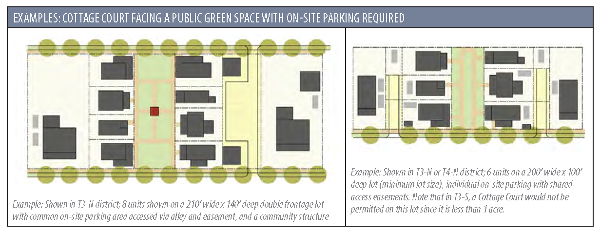
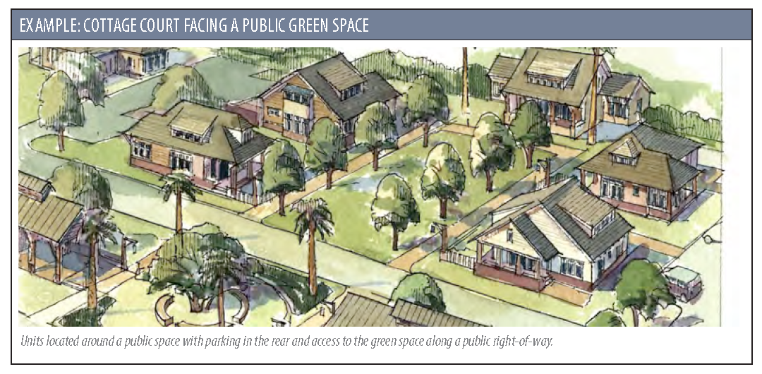
2.8.2 - COTTAGE COURTS (A.K.A. BUNGALOW COURTS, POCKET NEIGHBORHOODS, COURTYARD HOMES)
A.
Purpose: The alternative development options of this section allow for development of smaller dwelling units, organized around a common outdoor space, that are appropriate to the character of the surrounding neighborhood. They provide a space-efficient and economical alternative to traditional single dwelling unit development. The ownership model may be either fee-simple or condominium-style, and can achieve the same benefits as those listed in Section 2.8.1 A.
B.
Definition: A Cottage Court development is a residential development in which small buildings are oriented around a central green or open space that is accessible by all residents.
C.
Density: Additional density is permitted, as follows, in exchange for the buildings having a limited footprint, size, and height:
1.
In T3-S the overall density is permitted to be up to 1.25 times the maximum density limit.
2.
In T3-N the overall density is permitted to be up to 2 times the maximum density limit.
D.
Applicability: Cottage Courts are permitted in T3 and T4 districts only. They are not permitted in the Historic District.
E.
Lot Size: Prior to development, lots or combinations of lots shall meet the following dimensional standards:
1.
160 feet wide by 100 feet deep where formalized parking on-street exists on adjacent streets and no on-site parking is required.
2.
180 feet wide by 100 feet deep if on-site parking is required.
3.
Exception: In T3-S, Cottage Courts are limited to lots greater than 1 acre.
F.
Conflict with Other Regulations: If there is a conflict between the cottage courts standards of this section and any other requirement of this Code, the standards of this section control. Otherwise, cottage courts are subject to all other applicable requirements of this Code.
G.
Approval Procedure: Cottage courts are subject to the subdivision review procedures set forth in Section 9.9.
H.
Number of Buildings: Cottage courts shall contain a minimum of 4 residential buildings. For courts that have 8 or more buildings, a community structure shall be provided. Examples of these include garden sheds, pavilions, community houses, etc.
I.
Building Size and Details:
1.
Buildings may have a maximum 800 square foot footprint (not including porches), and may be no more than 1.5 stories tall.
2.
Front porches shall be provided facing the common space, and they shall be a minimum of 8 feet deep.
3.
Where a building is located on both a public street and a public space, it shall address the street with either a porch or stoop, and shall provide entries onto both spaces.
4.
The public spaces of the home shall be located facing the common space. These include living, dining, and kitchen areas. First-floor bedrooms should not be located fronting the civic space. An exception to this shall be made on corner lots, where public spaces may face the street.
J.
Setbacks and Building Separation: The minimum setback and frontage standards of the base zoning district apply along the perimeter of a cottage court development. Buildings may be attached or detached. All detached structures within a cottage court development shall be separated by a minimum distance of 10 feet. This distance may be reduced, subject to the building code.
K.
Parking Requirements and Configuration: One space per unit is required. Adjacent on-street parking spaces may count towards this requirement. Parking shall be screened from the public right-of-way by buildings. A common parking area, accessed via an alley, is recommended. If this is not possible, access easement(s) shall be provided as part of the final plat. Parking shall be screened from neighboring properties per the requirements of Section 5.7.8 A.
L.
Open Space Requirement: A minimum of 400 square feet of common open space is required per unit. The open space shall be connected to the public right-of-way either by opening up to the street, or via a paved path no less than 8 feet wide. Ownership and maintenance requirements shall be in accordance with Section 7.4.5.
2.8.3 - TRADITIONAL NEIGHBORHOOD DEVELOPMENT FLOATING OVERLAY DISTRICT
A.
Purpose and Intent: The Traditional Neighborhood Development (TND) overlay District is established to:
•
Support the development of fully integrated, mixed-use, pedestrian-oriented neighborhoods with a variety of housing choices.
•
Prevent the development of large, single-use, homogenous subdivisions.
•
Minimize traffic congestion, suburban sprawl, infrastructure costs and environmental degradation.
•
Create a streamlined way to transition the City's zoning to the Transect-zones.
B.
Process and Applicability: The application of the TND overlay district shall depend upon the size of the site in accordance with the provisions below. The TND overlay district shall not be applied to any site with a T1 (Natural Preserve District) base district designation.
1.
General Process:
a.
Master Plan: Applicants shall first develop and present a master plan, complying with the Sketch Plan requirements in 9.3.1.B, for the entire parcel which shall include land allocations by Transect zone, proposed subdivisions of property, required open space, street regulating plan, neighborhood structure(s) and other information required to indicate compliance with this section. Upon approval by the MPC - and subsequent rezoning approval as applicable - the master plan is vested.
b.
Preliminary Plat: Upon approval of the Master Plan, the applicant shall proceed towards approval of a Preliminary Plat (Section 9.9.3).
2.
Applicability:
a.
15—40 acres: Sites having at least 15 acres but less than 40 acres may be developed under a TND overlay district. Development sites with a base zoning of T3 shall be subject to the rezoning process consistent with Section 9.16. Development sites with a base zoning of T4 or T5 shall follow the procedures for Major Subdivisions found in Sections 9.9.3 and 9.9.4.
b.
40—100 acres: The TND overlay District designation shall automatically apply by-right to all development sites of at least 40 acres but less than 100 acres. Applicants shall have the option of developing such sites using the standards of the TND overlay district or the standards of the underlying base zoning district. The approval of TND master plans on such properties shall follow the procedures for major subdivisions found in Sections 9.9.3 and 9.9.4.
c.
100+ acres: The TND overlay District designation shall automatically apply by-right to all development sites of at least 100 acres. Development sites of this size are required to follow the standards of the TND overlay district. The approval of TND master plans on such properties shall follow the procedures for major subdivisions found in Sections 9.9.3 and 9.9.4.
d.
Exceptions: Land designated as LI and IC districts are not subject to these provisions and may be developed as more conventional, single-purpose developments.
C.
Land Allocation by Transect Zones: When composing the TND master plan, the Transect-based districts in Section 2.3.2 shall be used as sub-districts within the ranges noted in the following chart. The allocation of land by Transect zone shall be made a part of all applications and approvals for TND master plans. All development shall conform to the standards of the designated form-based sub-district in which it is located, unless otherwise noted in this section.
* Listed as % of gross land area.
Note: T4-NA sub-district may be incorporated as no more than 1/3 of the permitted T4 allocation.
D.
Land Uses:
1.
The TND master plan shall include a regulating plan designating each Transect zone (T-zone) by parcel.
2.
Land uses shall be limited to those permitted in the designated T-zone.
3.
Similar T-zones shall generally front across streets. Dissimilar categories shall abut at rear lot lines or transition mid-block.
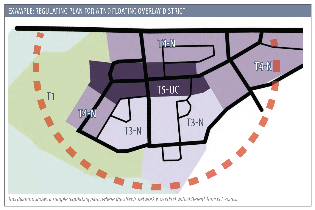
E.
Civic/Open Space:
1.
Development shall be required to reserve usable, common open space in accordance with the standards for the underlying base district(s), as specified in Sections 7.4.2 and 3.
2.
No portion of the TND shall be further than ¼ mile from a Community Green Space, as defined in Section 7.4.3. Existing common open spaces outside of the TND boundaries may be used to satisfy this requirement.
3.
On parcels 40 acres and larger, a minimum of 2% of the gross land area shall be reserved for the construction of community structures, (schools, community buildings, religious institutions, etc.) and their support facilities (parking areas, etc.). These sites shall be counted towards the open space requirement. Such sites shall be easily accessible within the neighborhood — and to the greater community where appropriate — and shall help to visually anchor important vistas. See Section 4.5.13 for building design standards for civic buildings. If after 5 years, the community facilities are not constructed, the land may be converted to common open space.
F.
Neighborhood Structure:
1.
TNDs shall be organized by individual pedestrian sheds (or walking areas) with a ¼-mile radius (1,320 linear feet).
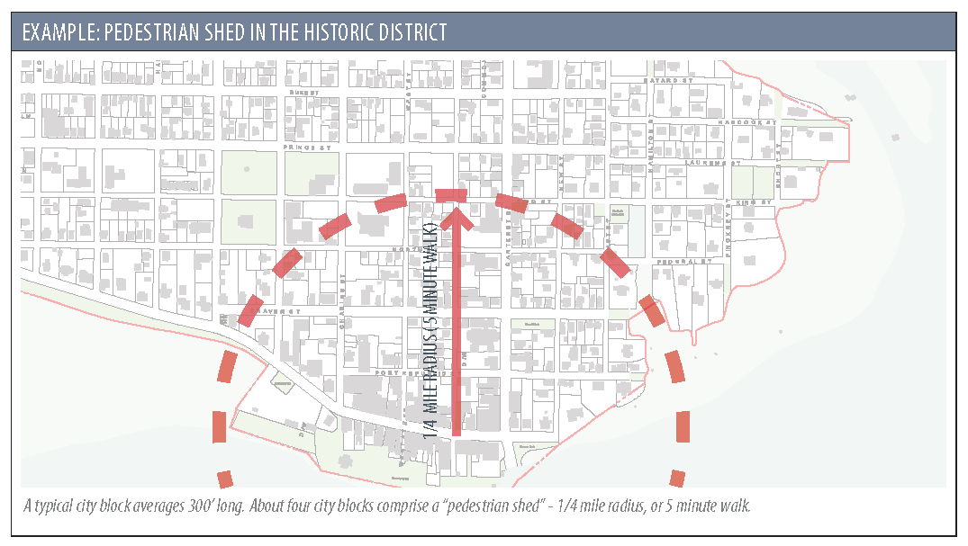
2.
Neighborhood centers/main streets shall be located at or near the center of all pedestrian sheds, and shall include:
a.
The area of the TND with the greatest intensity of development,
b.
One or more civic buildings and/or uses, and
c.
One or more Community Green Spaces.
3.
Each pedestrian shed is encouraged to include a variety of uses, building types, and housing types, so that the majority of lots within the TND are within walking distance (no more than ½ mile) of a neighborhood center, and at least 2 types of housing are provided (e.g., single-family detached, rowhomes, duplexes, apartments) per pedestrian shed.
4.
Street networks shall be interconnected using a grid or modified grid. Exceptions and special designs can be considered due to geography and special site conditions.
5.
Block Size: Blocks shall be compact so that they are comfortably walkable and appropriate for their context.
a.
In T3-S zones, block sizes are flexible, but the perimeter shall not exceed 2,640 linear feet (½ mile). An average block perimeter less than 2,000 feet is preferred.
b.
In T3-N zones, block sizes are flexible, but the perimeter shall not exceed 1,700 linear feet (½ mile). An average block perimeter less than 1,500 feet is preferred.
c.
In T4, and T5 zones, blocks shall be no more than 400 feet on any side. An average block length of 250-300 feet is preferred. The block perimeter shall not exceed 1,320 linear feet (¼-mile).
d.
Exceptions may be made for natural elements such as wetlands, trees, topography, to be incorporated into the site design.
6.
Within 200 feet of all parcels outside the TND, lot widths, depths, and building types shall provide a graduated transition to adjacent development, particularly any such areas that are of a lower intensity/density.
G.
Relief: Modifications to these standards may be reviewed and permitted by the MPC if the plan is found to still be in compliance with the intent of this Code.
2.8.4 - PLANNED UNIT DEVELOPMENT DISTRICT (PUD)
A.
Purpose and Intent: The PUD is intended to encourage innovative land planning and site design concepts that cannot be achieved by other mechanisms provided by this Code. PUDs should achieve a high level of environmental sensitivity, aesthetics, high quality development and other community goals by:
1.
Allowing greater freedom in selecting the means to provide access, open space and design amenities.
2.
Promoting quality urban design and environmentally sensitive development by allowing development to take advantage of special and unique site characteristics, locations, building types and land uses.
B.
Process and Applicability:
1.
General Process: PUDs are considered a two step process. First, there is a Rezoning which follow the general procedures of Section 9.16. Second, a Final Plat approval, per Section 9.9.4 shall occur. A complete master plan and written report shall be developed and submitted for approval as part of the rezoning process in order to determine the desired standards and design of the project. Those documents shall be submitted in accordance with the following standards:
a.
Master Plan: Applicants shall first develop and present a master plan, complying with the Sketch Plan requirements in 9.3.1.B, for the entire parcel which includes, but is not limited to:
i.
Size: Size, in acres, shall be listed on the master plan. For redevelopment sites, as defined in Section 8.3.2 A., PUDs shall have a minimum of 4 acres. For all other developments PUDs shall have a minimum of 10 acres. If the project is intended to be developed in phases, the master plan shall include all phases.
ii.
Districts: Land allocations by zoning district, including specific modifications to the Code requirements of those districts clearly highlighted.
iii.
Street Layout and Regulating Plan: the design and location of the streets shall be provided. Streets shall conform with the street sections in Appendix C of this Code. Additional bicycle and pedestrian circulation shall also be indicated.
iv.
Lot Layout: Proposed subdivisions of property, required open space, street regulating plan, neighborhood structure(s). The PUD shall have provisions to allow for a systematic methodology to provide a variety of lot sizes.
v.
Open Space: Open space requirements are 1.5 times the standards set in Section 7.4.2 with the exception that a minimum of 10% open space is required for all PUDs, regardless of size or zoning district. These should be clearly indicated on the master plan.
vi.
Community Space: the requirements of 2.8.3.C.3 shall be met.
vii.
Stormwater Requirements: Stormwater shall be considered on a PUD-wide basis and the general locations shall be indicated. Floodplain information shall also be included on the master plan.
viii.
Resources: The general location of all historic, cultural, and environmentally sensitive resources shall be depicted on the master plan.
b.
Written Report: A written report shall be submitted to explain the type, nature, intent and characteristics of the proposed development, and shall specifically include:
i.
Site Description: A general description of the proposal, including a detailed description of the site, location, context, and any cultural, environmental and/or historic resources.
ii.
Vision Statement: The goals, tenets, any special initiatives which the development intends to achieve shall be clearly identified for review and discussion.
iii.
Incompatibilities: A detailed description of the provisions of the Code which prevent the development, as desired shall be provided. This shall include analysis showing how the general Land Development standards in Article 7, and the TND Floating Overlay District standards in Section 2.8.3 limit the intended development.
iv.
Modification to Code: A detailed description of exceptions or variations from the requirements of this Code, per the incompatibilities listed above. All items not explicitly listed as modifications will be subject to the requirements of this Code.
v.
Land Allocation: Tables showing the total number of acres in the proposed development and the percentage designated for each proposed type of land use, including open spaces, recreation areas, public facilities, wetlands and wetland impacts. This should be coordinated with the Districts as shown in the master plan. If the development is intended to be phased, the phasing plan shall be indicated on the tables.
vi.
Program: A complete development program, including number of residential units and proposed densities, building types, minimum and maximum lot sizes, and square feet and identification of other nonresidential uses.
vii.
Building Design Standards: Guidelines to achieve aesthetics and high quality development shall be included. These may be further elucidated in the covenants after all City approvals have been secured.
viii.
Compatibility Statement: A statement of how the proposed development is consistent adopted plans and documents, including, but not limited to, the Civic Master Plan, the most recent Comprehensive Plan, applicable stormwater regulations, other model ordinances and/or applicable development standards.
ix.
Other: Additional relevant information as requested by the Administrator.
c.
Performance Guarantee: Before approval of a PUD, the City Council may require a contract with safeguards satisfactory to the City guaranteeing completion of the development plan in a period to be specified by the City, but which period shall not exceed 5 years unless extended by the City for due cause show. Such guarantee may include the submission of a performance bond in an amount set by the City.
d.
Final Plat: Upon approval of the Rezoning (inclusive of the master plan), the applicant shall proceed towards approval of a Final Plat (Section 9.9.4).
C.
Expiration of Approval: The City shall have the right to review a concept plan approved as part of a PUD when no building permits have been issued in the past 5 years, and may choose not to issue further permits within the PUD until a revised concept plan has been approved.
2.8.5 - LEGACY PLANNED UNIT DEVELOPMENT DISTRICT (LPUD)
A.
Purpose: The legacy planned unit development (LPUD) zoning district is intended to be utilized only for the continuation of previously established PUDs.
B.
Minor Plan Amendments Permitted by the Administrator: The amendment of previously approved PUDs shall be approved by the Administrator, if the amendment results in a development intensity that is no greater than the previously approved intensity in terms of total square feet, total number of units, height, and build-upon area. Additionally, a minor plan amendment shall be limited to technical considerations that could not be reasonably anticipated during the approval process, or any other change that has no material effect on the character of the approved PUD development or any of its approved terms or conditions.
C.
Major Plan Amendments Permitted by City Council Approval Only: All major changes not subject to B, above, shall be reviewed by the Planning Commission (PC) and approved by City Council in accordance with the procedures outlined in Section 2.8.4 B.1.
D.
Rezoning a PUD: Any existing LPUD may choose to rezone to a standard City zoning district by going through the rezoning process in accordance with the procedures outlined in Section 9.16.
(Ord. No. O-14-23, 9-26-2023)