
Forsyth County Unincorporated
City Zoning Code
City Zoning Code
CHAPTER 18
- SUBDIVISIONS AND LAND DEVELOPMENT20
Cross reference— Buildings and building regulations, ch. 18; environment, ch. 34; floods, ch. 46; planning, ch. 58; roads and bridges, ch. 62, utilities, ch. 82.
ARTICLE IV. - DESIGN REQUIREMENTS FOR LOTS
This article shall apply to major and minor subdivisions, unless specifically indicated otherwise.
ARTICLE V. - REQUIRED IMPROVEMENTS
This article shall apply to major and minor subdivisions, unless specifically indicated otherwise.
ARTICLE VII. - SUPPLEMENTARY PROVISIONS FOR MINOR SUBDIVISIONS
Notwithstanding other provision of this chapter, minor subdivisions shall be governed by the following:
18-1.1. - Title.
These regulations shall be known and may be referred to as the Subdivision and Land Development Regulations of Forsyth County.
(Amd. of 2-2-2004)
18-1.2. - Purposes.
This chapter is adopted with the following purposes:
(a)
To promote the orderly, planned, efficient, and economic development of the unincorporated portions of Forsyth County and to guide future growth in accordance with the comprehensive plan.
(b)
To ensure that lands subdivided are of such character that they can be used for building purposes without danger to the health or safety of its residents, and to secure safety from fire, flood, or other menace.
(c)
To prevent the pollution of air, streams, and ponds; to encourage the wise use and management of natural resources throughout the unincorporated portions of Forsyth County, and to preserve the topography and beauty of the community and the value of land.
(d)
To ensure the proper provision of improvements such as drainage, water, sewerage, and capital improvements such as schools, parks, playgrounds, recreational facilities, and transportation facilities.
(e)
To provide for open spaces through the most efficient design and layout of the land.
(f)
To establish procedures for the subdivision and re-subdivision of land in order to further the orderly development of land.
(g)
To provide for the proper monumenting of subdivided land and proper legal descriptions.
(h)
To help eliminate the costly maintenance problems which develop when streets and lots are established without proper consideration given to various public purposes.
(i)
To facilitate and inform lot purchasers who generally lack the specialized knowledge needed to evaluate subdivision improvements and design.
(j)
To offer protection of natural resources through required buffers and undisturbed areas that minimize land disturbance and protect existing vegetation while allowing for the removal of non-native, invasive species at the discretion of the county arborist.
(k)
To accommodate low-impact stormwater best management practices, where appropriate, to improve water quality and infiltration.
(Amd. of 2-2-2004; Amd. of 8-12-2021)
18-1.3. - Authority and delegation.
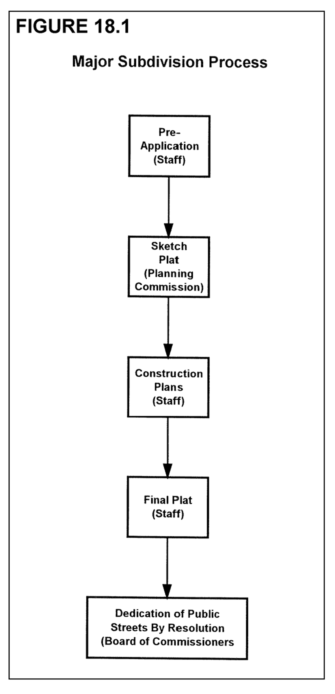
These regulations are adopted pursuant to powers vested in counties by the State of Georgia Constitution and pursuant to state administrative rules for the adoption and implementation of comprehensive plans and the protection of vital areas of the state. The board of commissioners is vested with the authority to review, approve, conditionally approve, and disapprove sketch plats, and to grant variances from the requirements of chapter 18 and chapter 19 of this Code when applications for variance(s) are submitted simultaneously with a sketch plat application and pertain to the same property as the sketch plat application.
The director of planning and community development is vested with the authority to review, approve, conditionally approve or disapprove final plats of minor subdivisions and minor re-subdivisions, lot combination plats, lot line adjustments, dedication plats, construction plans and final plats of major subdivisions when such sketch plat approval of construction plans has been obtained.
The director of planning and community development shall also be authorized to review major subdivisions and major re-subdivisions for conformity to the requirements of this Code, and to make reports and recommendations to the planning commission on major subdivisions and major re-subdivisions, and to administer, interpret, and enforce the provisions of this chapter. The director of planning and community development shall further be authorized to administratively approve variances where expressly authorized in this Code. The director of engineering is vested with the authority to require and approve improvements and improvement guarantees specified in this chapter.
(Amd. F of 5-12-2003; Amd. of 2-2-2004; Amd. of 11-15-2004; Amd. of 12-1-2011; Amd. of 7-18-2013)
18-1.4. - Applicability and prohibitions.
(a)
The subdivision regulations of Forsyth County shall apply to all real property within unincorporated Forsyth County, but specifically excluding the subdivision of property as outlined in section 18-1.5, "Exemptions."
(b)
Effect of prior subdivision regulations. At the subdivider's request, a plat that received preliminary approval under prior subdivision requirements may be processed through the final plat process under such requirements.
(c)
No person shall sell, advertise, or offer to sell, by deed, map, plat or other instrument, any parcel of land not subdivided under the requirements of this chapter.
(d)
No plat of land subdivision shall be entitled to be recorded in the Office of the Clerk of the Superior Court of Forsyth County, and it shall be unlawful to record such a plat of land subdivision, unless and until it shall have been approved in accordance with the requirements of this chapter.
(e)
It shall be unlawful for any person to transfer or sell land by reference to, or by exhibition of, or by other use of, a plat of a land subdivision that has not been approved and recorded in accordance with the requirements of this chapter. The description of such land by metes and bounds in the instrument of transfer shall not exempt the transaction.
(f)
No person shall commence construction of any improvements on any land, prior to the approval of construction plans and engineering plans for said improvements.
(g)
No building permit or certificate of occupancy shall be issued for a building, structure, or use, nor shall any excavation, grading, or land disturbance applications be approved, on any parcel of land created by subdivision after the effective date of this Code that has not been approved in accordance with the provisions of this chapter.
(h)
No land dedicated as a public street or for other public purpose shall be opened, extended, or accepted as a public street or for other purpose unless such improvements are constructed in accordance with the specifications of this chapter and formally approved and accepted as public improvements by the board of commissioners.
(i)
No street or road will be accepted for maintenance by the county unless the property owner(s) first constructs the road to county standards.
(Amd. of 2-2-2004)
18-1.5. - Exemptions from plat approval.
The following types of land divisions, transfers, and sales are specifically exempted from the plat approval requirements of this chapter; provided, however, that such exemptions shall not apply to land development requirements of this chapter, and such exemptions shall not require the county to issue permits should the resulting lots or parcels not meet applicable requirements of this Code.
(a)
The creation and sale of cemetery plots.
(b)
The sale of lots consistent with previously approved and recorded plats or deeds.
(c)
The creation of leaseholds for space within a multiple-occupancy building or the division of property into leaseholds for commercial, industrial, or institutional use.
(d)
The creation of leaseholds for the agricultural use of property where the use does not involve the construction of a building to be used as a residence or for other purpose not directly related to agricultural use of the land or crops or livestock raised thereon.
(e)
Any division of land to heirs through a judicial estate proceeding, or any division of land pursuant to a judicial partition, or any division of land occurring from the foreclosure of a deed of trust.
(f)
Dedication plats prepared for the sole purpose of conveying right-of-way for a public street or highway to Forsyth County, the City of Cumming, or the State of Georgia; provided, however, that such road right-of-way dedication plat shall bear the signature of the director of engineering prior to its recording.
(Amd. of 3-26-2001; Amd. of 2-2-2004)
18-1.6. - Variances.
Repealed 3-26-01.
18-1.7. - Appeals.
Any person aggrieved by an interpretation or decision of the director, director of engineering, or director of water and sewer, or other official responsible for the administration of this chapter may file an appeal to the Forsyth County Zoning Board of Appeals.
(Amd. of 2-2-2004; Amd. of 11-15-2004)
18-1.8. - Enforcement, violations, and penalties.
The director of planning and community development shall enforce the provisions of this chapter. The director is authorized to issue stop-work orders and issue citations for violations of this chapter. If it is discovered that a plat was recorded but was not eligible for recording under the provisions of this chapter, then in such an event the director shall cause to be filed a notice of revocation of approval of said plat in the clerk's office, Forsyth County Superior Court, with cross reference noted on the plat to the filed revocation, in a form to be approved by the county attorney. In addition to remedies associated with violations to this Code, the director may institute proceedings to obtain injunction, abatement, or any other appropriate action or actions, to prevent, enjoin, or abate such unlawful action.
(Amd. of 2-2-2004; Amd. of 12-1-2011)
18-2.1. - Land is one tract until subdivided.
Until property proposed for subdivision has received plat approval and been properly recorded, the land involving the subdivision shall be considered as one tract.
(Amd. of 2-2-2004; Amd. of 11-11-2012)
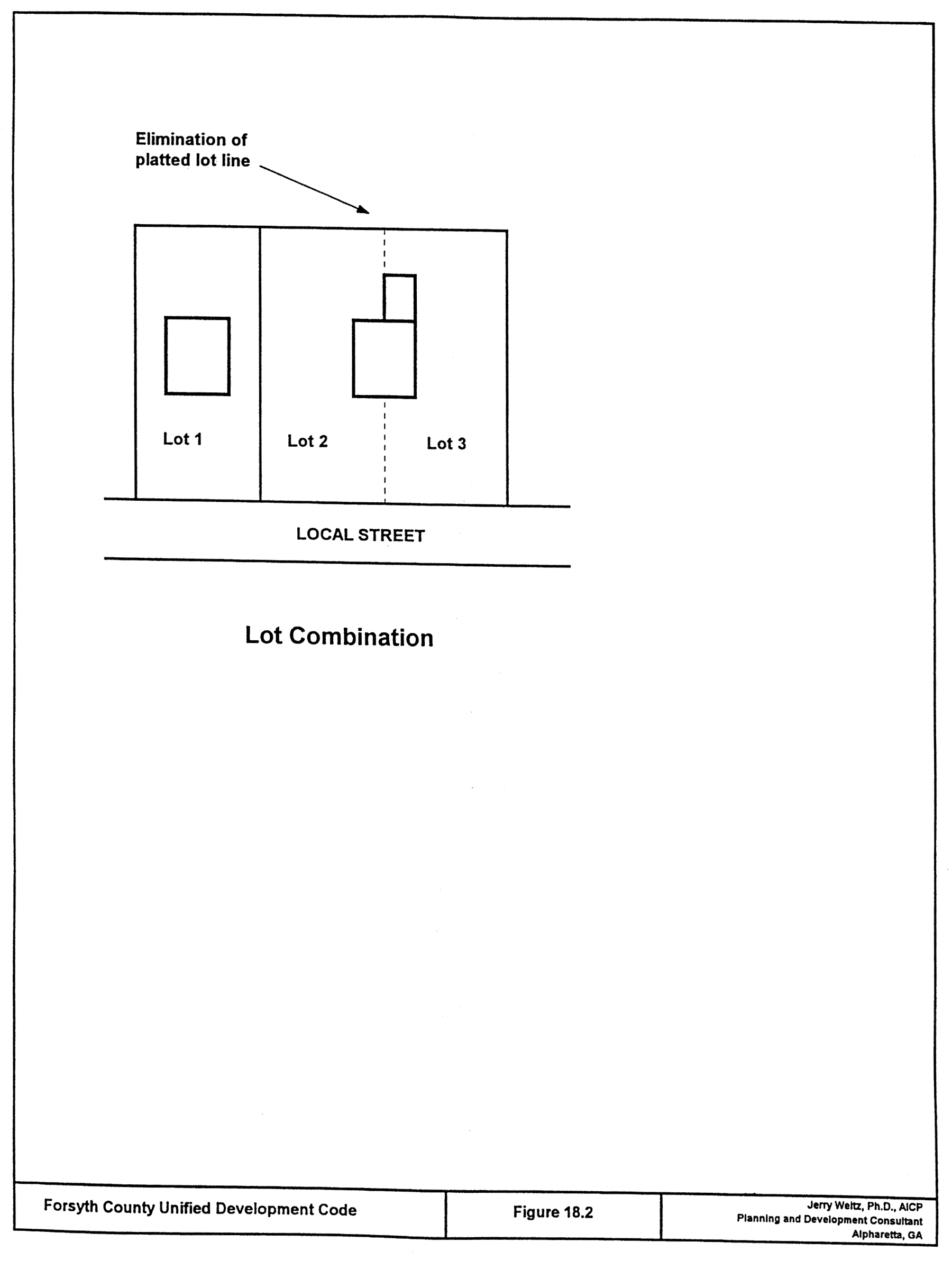
18-2.2. - Lot combinations.
An existing lot line forming the boundary between two lots located within the same subdivision may be removed or eliminated through the plat revision process which conforms to the requirements of this chapter. The combining of lots that are not located in the same subdivision is prohibited, except that lots that were formerly in different subdivisions may be combined where applicable covenants have expired either by their own terms or by application of law, provided that the proposed lot combination between lots in such different subdivisions is approved by the board of commissioners in compliance with the sketch plat approval procedures at UDC 8-5.3(d), irrespective of the acreage involved. In the case no plat applies to the subject lots or parcels, a boundary survey and plat depicting all lots involved in the lot combination shall be required to be approved by the director and recorded. Such combination plat shall be titled with the same name as that of the original subdivision and shall indicate thereon that the replat is for the purpose of removing the lot lines between specific lots. For purposes of this paragraph only, the term subdivision shall have the meaning set forth in chapter 3 but shall also mean lots that are encumbered by effective, valid and enforceable covenants.
(Amd. of 2-2-2004; Amd. of 11-11-2012; Ord. of 10-6-2016(1), § 1)
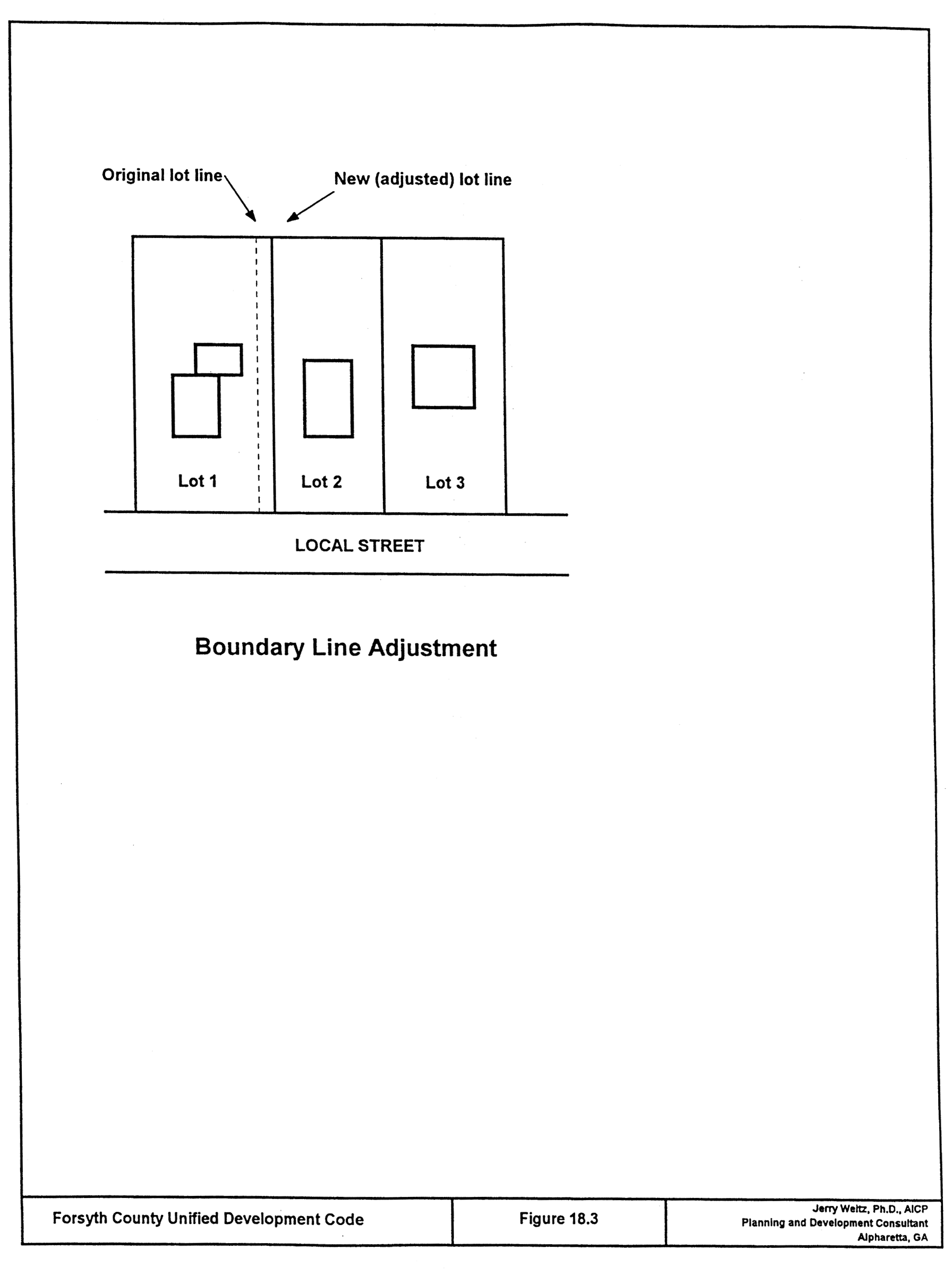
18-2.3. - Boundary line adjustments.
One or more existing lot lines forming boundaries between platted lots located within the same subdivision, or one or more lot lines between abutting lots or parcels may be adjusted through a final plat revision process that requires the approval of the director and recording of a plat meeting the specifications of a final plat. In the case no final plat applies to the subject lots or parcels, a boundary survey and plat of the entire lots involved in the boundary line adjustment shall be required to be approved by the director and recorded. Such plat showing said boundary line adjustment shall be titled with the same name as that of the original subdivision and shall include thereon that the replat is for the purpose of adjusting the lot lines between specific lots.
(Amd. of 2-2-2004; Amd. of 11-11-2012)
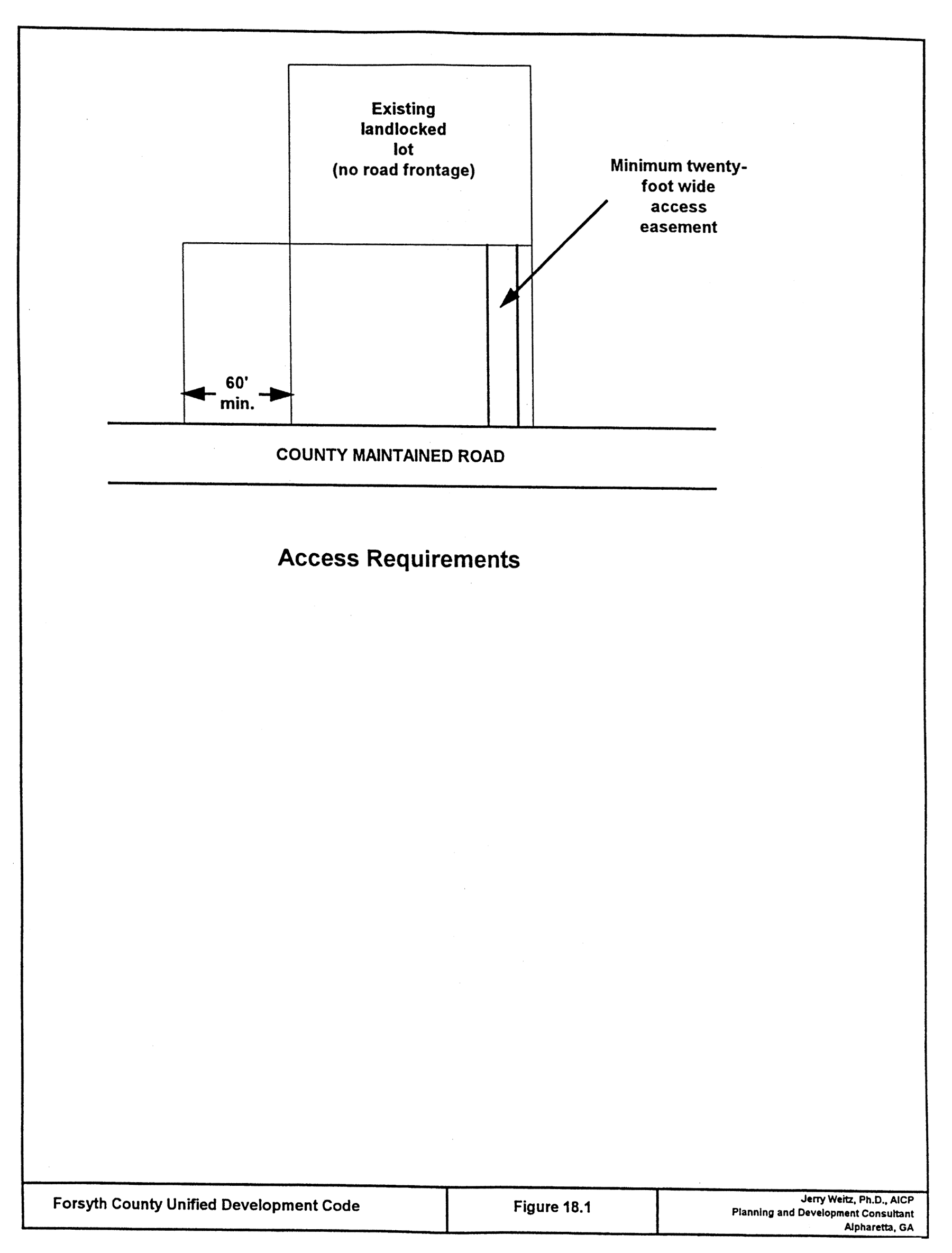
18-2.4. - Access requirements.
(a)
Minimum access standards. All lots and tracts hereafter created must front a minimum of 60 feet on a county, city, or state approved public road, with the exception of cul-de-sac lots, which must front a minimum of 20 feet on a county approved public road. In the event property is a landlocked lot, as of the effective date of this Code, the property owner shall acquire a minimum 20-foot easement to a state, city, or county-maintained road, and said easement shall be duly recorded and made a part of the property deed. No building permit shall be issued for any lot that does not meet the minimum access standards of this section, except as otherwise specifically permitted, until such time as there exists a road or street meeting all county standards.
(b)
Plats straddling jurisdictional boundaries. Whenever access to the subdivision is required across land within the jurisdictional boundaries of another local government, the planning commission may request assurance from the local government authority that access is legally established, and from the local government engineer that the access road is adequately improved, or that a guarantee has been duly executed and is sufficient in amount to assure the construction of the access road. In general, lot lines should be laid out so as not to cross jurisdictional boundary lines.
(c)
Additional rights-of-way. Subdivisions that adjoin existing streets shall dedicate additional right-of-way to meet the minimum street width requirements specified by the county's major transportation plan, and the entire right-of-way shall be provided where any part of the subdivision is on both sides of the street; provided that when the subdivision is located on one side of an existing street, one-half of the required right-of-way, measured from the center line of the existing roadway, shall be provided.
(Amd. of 2-2-2004; Amd. of 11-15-2004)
18-3.1. - Requirements for streets.
(a)
Public streets required. Access to every lot in a major subdivision shall be provided over a public street, whether it is privately maintained or maintained by the county. Construction of a privately maintained road requires prior approval by the board and must be constructed to current county standards. All streets and other features in the major transportation plan of Forsyth County, Georgia, shall be platted by the subdivider in the locations and to the dimensions indicated in the major transportation plan adopted by the board of commissioners.
(b)
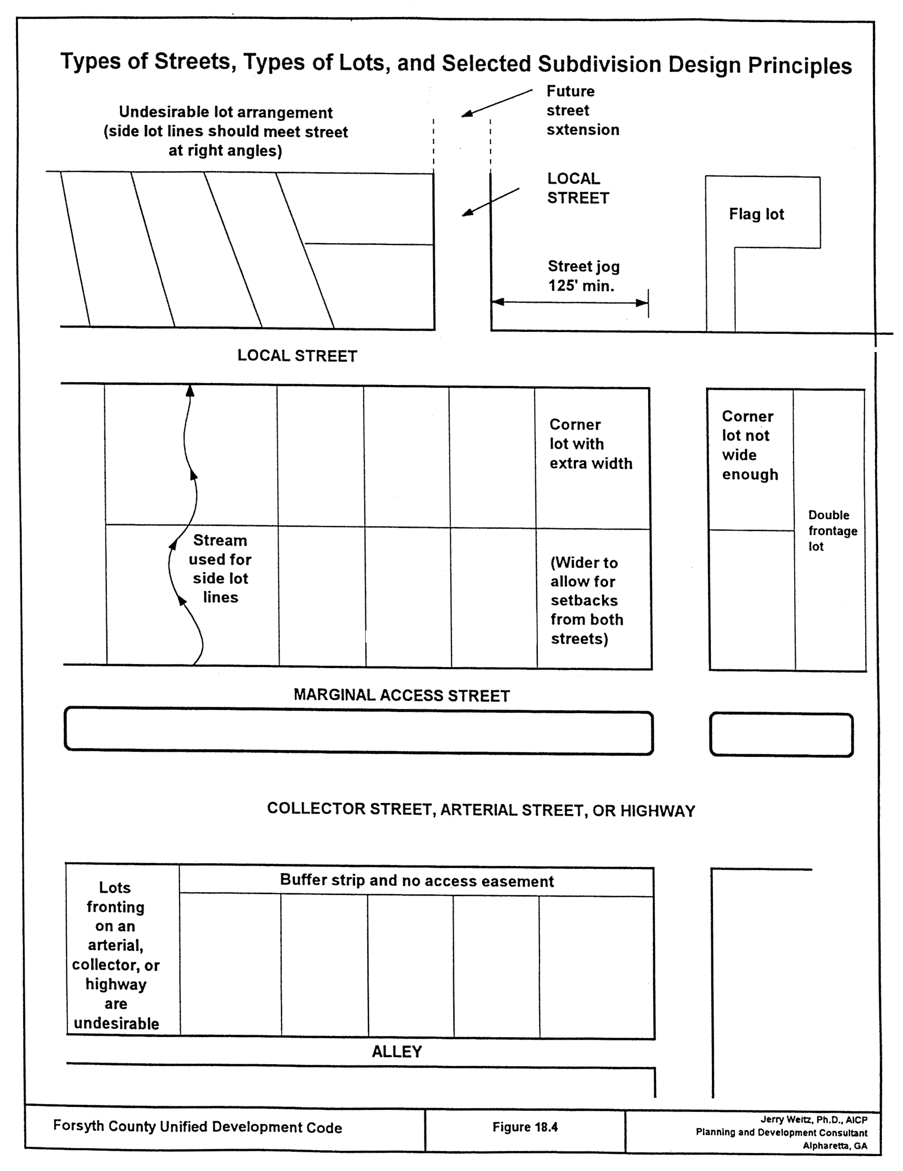
Street alignment, intersections and jogs. Streets shall be aligned to join with planned or existing streets. Under normal conditions, streets shall be laid out so as to intersect as nearly as possible at right angles. Street jogs with center-line offsets of less than 150 feet shall not be permitted.
(c)
Continuation of existing streets and connections. Existing streets shall be continued as the same or greater width, but in no case less than the required width. The planning commission or board of commissioners may require that a major subdivision provide one or more future connections to adjoining subdivisions or unsubdivided tracts.
(d)
Street plans for future phases of the tract. Where the plat proposed to be subdivided includes only part of the tract owned or intended for development by the subdivider, a tentative plan of a future street system for the portion not slated for immediate subdivision consideration shall be prepared and submitted by the subdivider.
(e)
Marginal access streets. Whenever the proposed subdivision contains or is adjacent to the right-of-way of a U.S. or state highway, a marginal access street approximately parallel and adjacent to such right-of-way may be required at a distance suitable for the appropriate use of land between such street and right-of-way.
(f)
Alleys and service access. Alleys may be provided. If they are provided, they must be paved. The pavement width of an alley must be no wider than 20 feet. Dead-end alleys shall be avoided were possible; but if unavoidable, they shall be provided with adequate turn-around facilities. Service access shall be provided in commercial and industrial districts for off-street loading, unloading, and parking consistent with and adequate for the uses proposed.
(g)
Street and subdivision names. Street and subdivision names require prior approval by the county. Street and subdivision names shall not be approved that will duplicate or be confused with names of existing streets and subdivisions in the county.
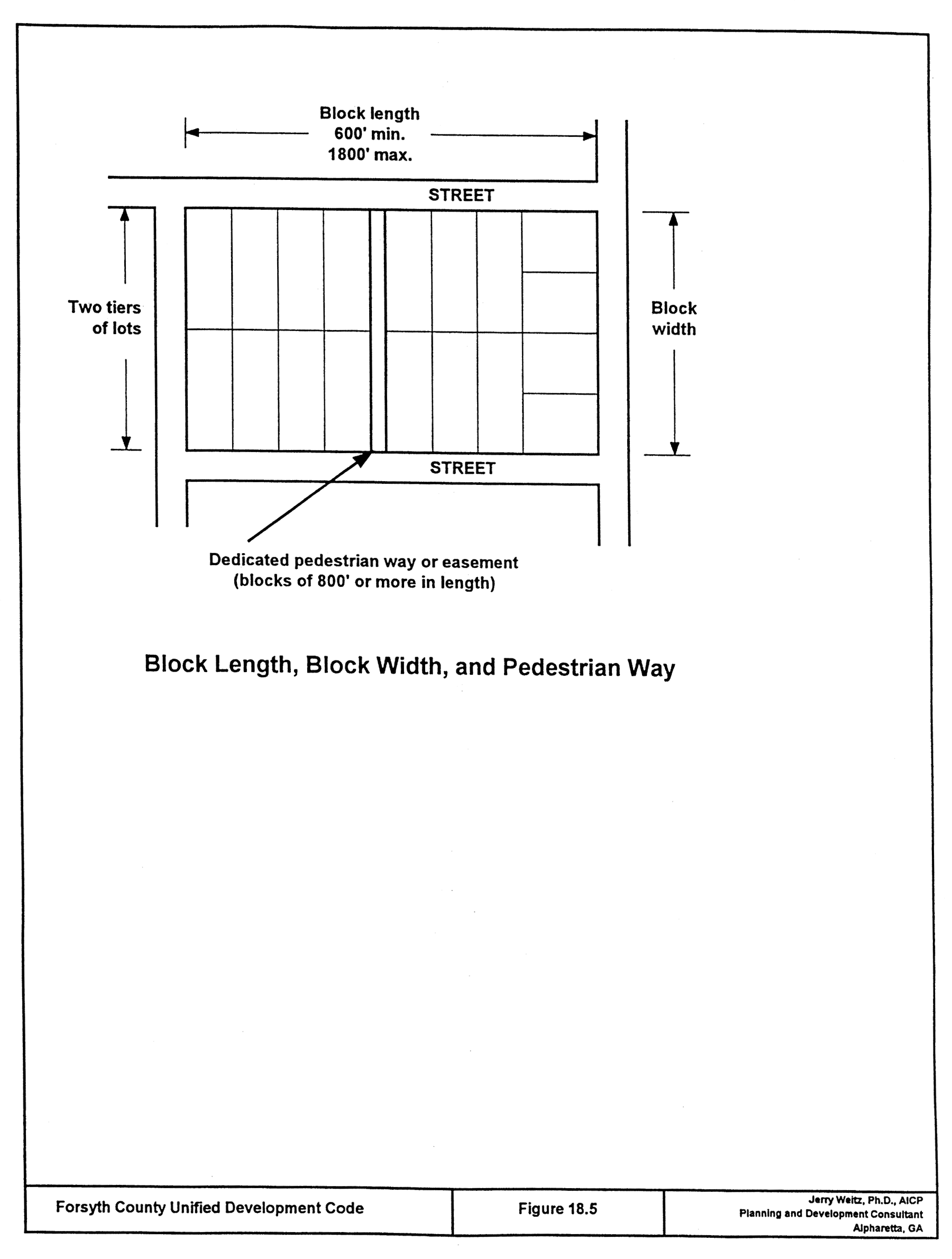
(h)
Block length. Intersecting streets shall be provided at such intervals so as to provide adequate cross traffic. Blocks in residential subdivisions should not exceed 1,800 feet nor be less than 600 feet in length, except where topography or other conditions justify a departure from these standards. In blocks longer than 800 feet, pedestrian ways and/or easements through the block may be required by the planning commission near the center of blocks.
(i)
Block width. The width of the block shall normally be sufficient to allow two tiers of lots of appropriate depth. Blocks intended for business or industrial use shall be of such width as to be considered most suitable for their respective use, including adequate space for off-street parking and deliveries.
(j)
Street entrances. All street entrances to major subdivisions must be landscaped per plans submitted to and approved by the Forsyth County Department of Planning and Community Development. The proposed location of street entrance monuments, if provided, must be shown on the final plat and approved by the county. Street entrance monuments must be setback ten feet from the right-of-way or out of the clear zone for the main road, whichever is greater. Required landscaping must be in place prior to the approval of a final plat; provided, however, that the director may allow the planting of landscaping to be delayed by one season, when there exists adverse seasonal weather conditions, subject to the posting of a landscape bond in a form approved by the director.
(Amd. of 3-26-2001; Amd. of 2-2-2004; Amd. of 11-15-2004; Amd. of 12-1-2011)
18-3.2. - Dedications, generally.
Subdivision streets and rights-of-way and other lands to be dedicated to the public shall be accepted by the county only upon the delivery to the board of commissioners of the general warranty deed conveying fee simple title of such right-of-ways and lands. The warranty deed shall be accompanied by an attorney's certificate of title and a tax transfer form addressed to the Forsyth County Board of Commissioners certifying that the grantor in such deed is vested with marketable fee simple title to the property conveyed thereby, free and clear of all liens and encumbrances, and further that the individual executing such deed has full authority to do so. Acceptance of such dedication shall be accomplished by resolution of the board of commissioners, a certified copy of which resolution shall be attached to both the deed of dedication and the final plat.
(Amd. of 2-2-2004)
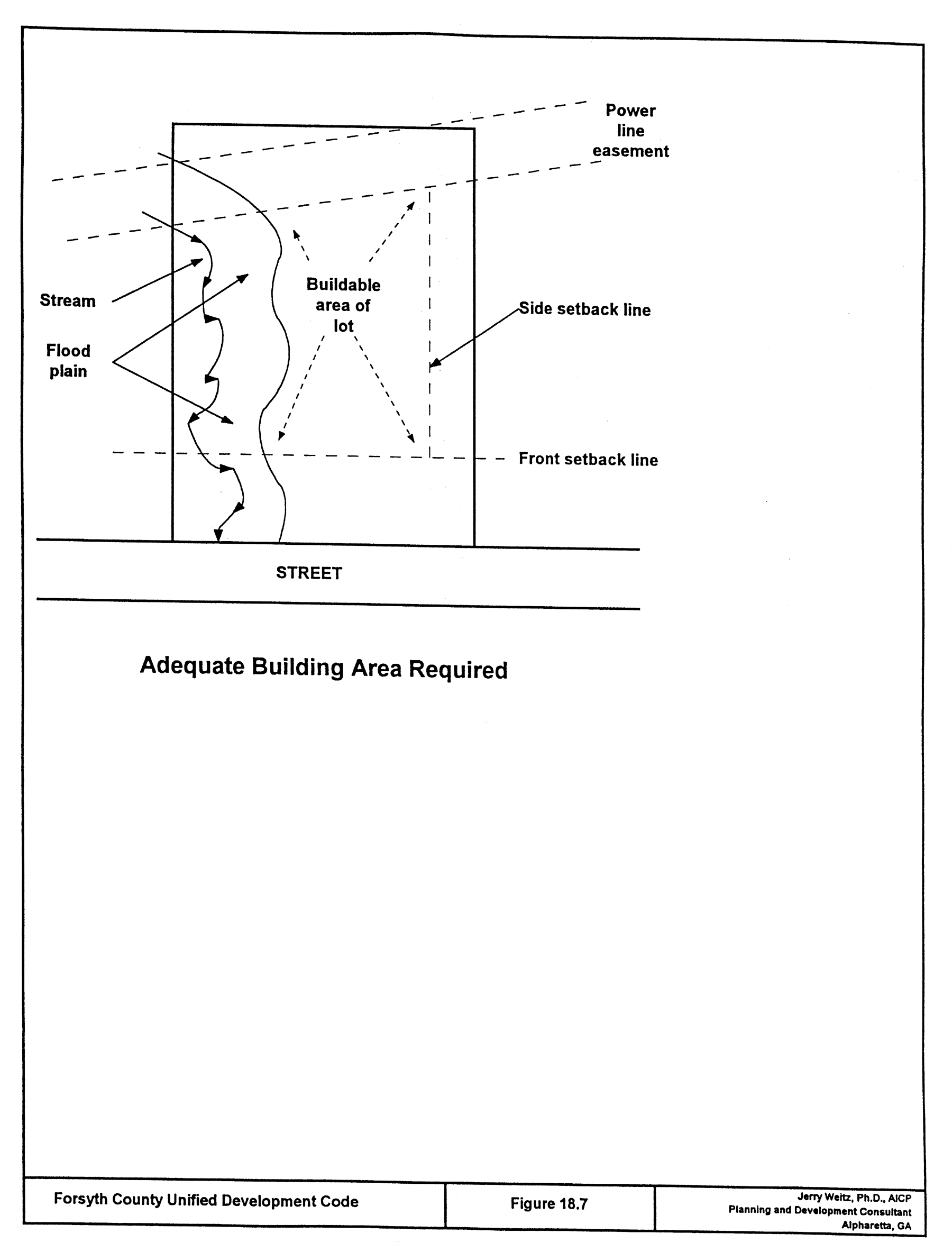
18-4.1. - Adequate buildable area required.
Land subject to flooding, improper drainage or erosion, or that is unsuitable for residential use for topographical or other reasons, shall not be platted for residential use nor for any other use that will continue or increase the danger to health, safety, or of property destruction, unless the hazards can be and are corrected. Each lot shall contain an adequate building site not subject to flooding and outside the limits of any existing easements or setbacks required by this Code.
(Amd. of 2-2-2004; Amd. of 11-11-2012)
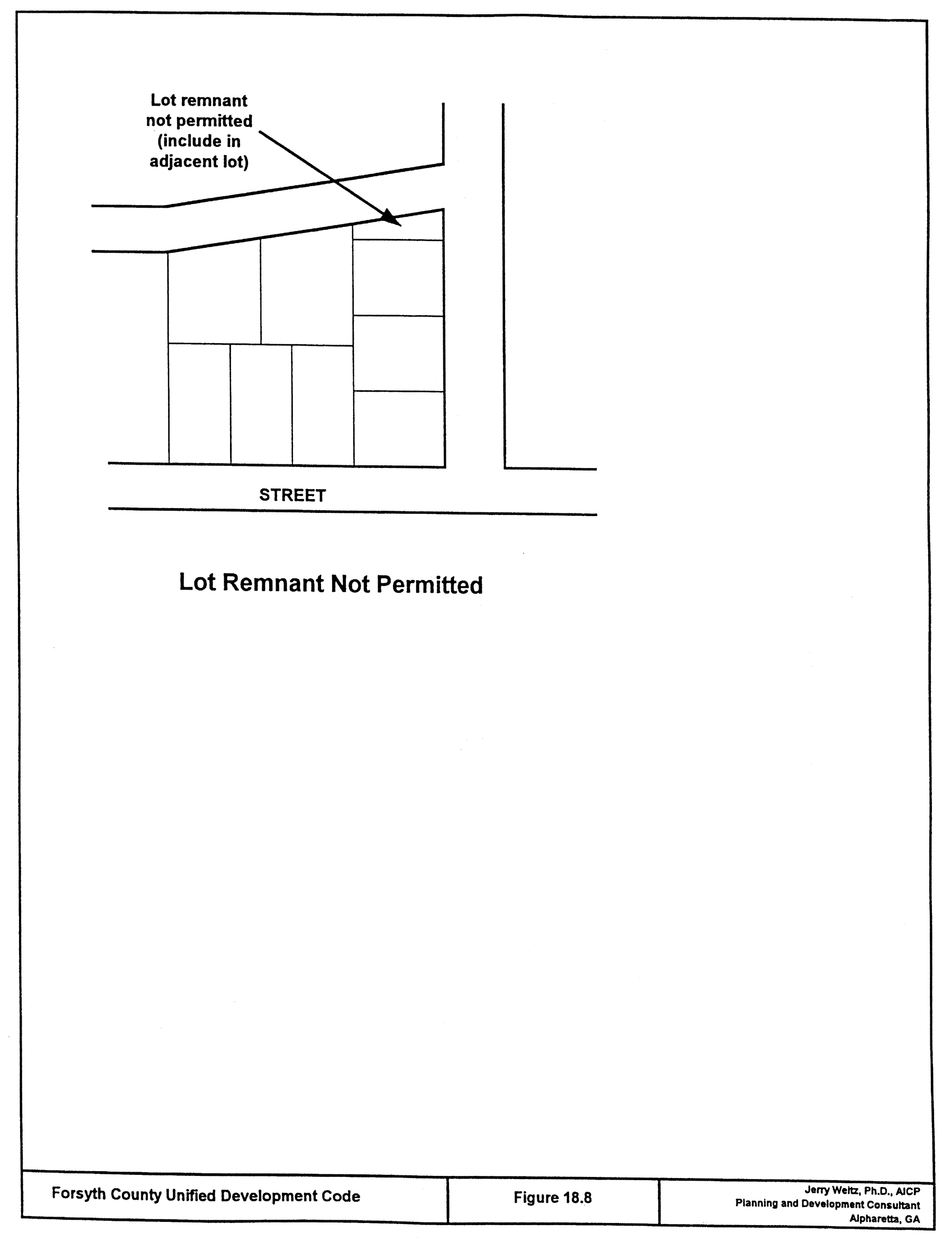
18-4.2. - Lot remnants shall not be permitted.
All remnants of lots below minimum size left over after subdividing of a larger tract must be added to adjacent lots, rather than allowed to remain as unusable parcels. The director of planning and community development may permit a lot remnant for a specific purpose such as a detention pond, provided that access and design is appropriate and the lot remnant is restricted to specific non-building use.
(Amd. of 2-2-2004; Amd. of 12-1-2011)
18-4.3. - Service areas.
Commercial and industrial lots shall be adequate to provide service areas and off-street parking suitable to the use intended.
(Amd. of 2-2-2004)
18-4.4. - Lot area.
The minimum lot area shall not be less than that established by the zoning district in which the subdivision is located.
(Amd. of 2-2-2004)
18-4.5. - Lot width.
No portion of a lot shall be narrower than 60 feet, with the exception of cul-de-sac lots and lots on the inside of curves whose side property lines are perpendicular or radial to the road.
(Amd. of 2-2-2004)
18-4.6. - Side lot lines.
Insofar as practical, side lot lines shall be at right angles to straight street lines or radial to curved street lines.
(Amd. of 2-2-2004)
18-4.7. - Corner lots.
For residential corner lots, the front setback requirements established in Table 11.2(a) and Table 11.2(b) shall be observed along both street frontages. The applicant shall designate the rear lot line.
(Amd. of 2-2-2004; Amd. of 11-1-2007; Amd. of 11-11-2012; Amd. of 4-20-2023)
18-4.8. - Lot depth.
Residential lots shall have a depth of not less than 100 feet, unless circumstances make these limitations impracticable.
(Amd. of 2-2-2004)
18-4.9. - Double frontage lots.
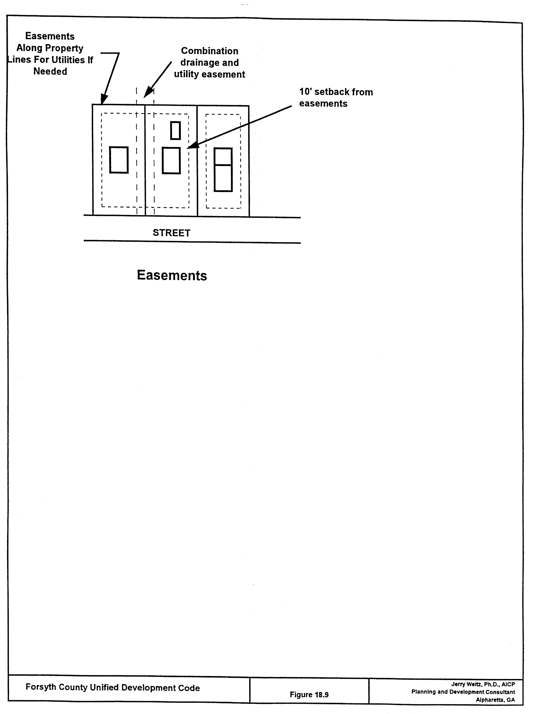
Double frontage and reverse frontage lots should be avoided except where essential to provide separation of residential development from arterials or overcome specific disadvantages of topography or orientation. A ten-foot no access easement shall be required along one of the frontages.
(Amd. of 2-2-2004; Amd. of 11-15-2004)
18-4.10. - Locations adjacent to major street.
Where a subdivision borders a freeway, a major arterial, or any other major source of noise, the subdivision should be designed to reduce noise in residential lots to a reasonable level via a landscaped buffer area or lots with greater depth from the major street to enable increased setbacks from the street. Double frontage lots with frontage on a major arterial shall have additional depth in order to allow space for screen planting along the lot line abutting a major arterial. The director may require a ten-foot no access easement for double frontage lots for the section of a lot abutting the major arterial.
(Amd. of 2-2-2004; Amd. of 11-15-2004; Amd. of 11-11-2012)
18-4.11. - Drainage.
Where the subdivision is traversed by a watercourse, drainage way, channel or stream, there shall be provided a stormwater or drainage easement of adequate width as determined by the director of engineering and as set forth in section 18-5.15. Drainage shall also be designed in accord with Ordinance No. 75 (Stormwater Management Ordinance), the Georgia Stormwater Management Manual and the Forsyth County Addendum that provides the county with the authority to manage drainage. If there exists a conflict between this paragraph and Forsyth County's Stormwater Management Regulations, the stricter stormwater requirement shall control. Parallel streets may be required by the planning commission in connection therewith.
(Amd. of 2-2-2004; Amd. of 11-1-2007)
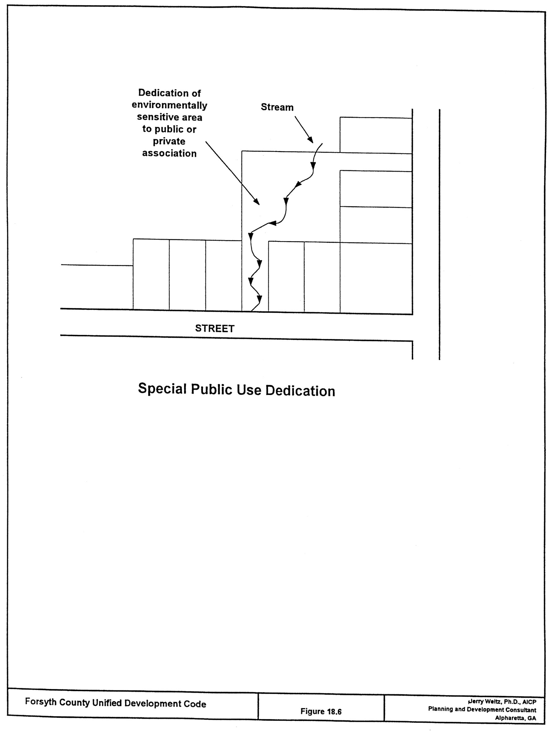
18-4.12. - Natural features and assets.
In the subdividing of land, due regard shall be shown for all natural features, such as tree growth, watercourses, historic sites or similar conditions which, if preserved, will add attractiveness to the proposed development and safety from hazards.
(Amd. of 2-2-2004)
18-4.13. - Flag lots and tracts prohibited.
No lot within a major subdivision plat shall be approved which constitutes a flag lot.
(Amd. of 2-2-2004)
18-5.1. - Required improvements.
Each subdivider, and each developer of a lot that abuts a public street, shall be required to submit plans and make the improvements required by this chapter in accordance with the established rules and procedures in this article and the Forsyth County Engineering Department's Construction Standards and Specifications or as otherwise adopted by the Forsyth County Engineering Department. No subdivision plat shall be granted final approval, and no certificate of occupancy for any building shall be granted, until the improvements required of that subdivision or land development have been installed.
(Amd. of 2-2-2004)
18-5.2. - Improvements mandatory.
Every subdivider/developer shall be required to make the improvements in accordance with the specifications herein and otherwise adopted by Forsyth County.
(Amd. of 2-2-2004)
18-5.3. - Plans required.
No person shall construct or install any public or private utilities or improvements required by this chapter without first obtaining county review and approval of engineering plans, profiles and specifications therefor.
(Amd. of 2-2-2004)
18-5.4. - Engineered drawings.
Engineering drawings for public streets, including cross sections and centerline profiles, and public and private water, sewer, and utility systems, certified by a professional engineer registered in the State of Georgia, or if authorized under state law, a registered land surveyor, or professional landscape architect, shall be required to be submitted for review and approval, and such plans must meet the requirements of the Forsyth County, Georgia, Construction Standards and Specifications and applicable provisions of this Code. Prior to approval and recording of a final plat, a registered land surveyor or professional engineer for the subdivider/developer shall submit one copy of all finished, as-built plans of improvements, demonstrating that said improvements, as installed, meet the requirements of this chapter and certifying that the plans accurately reflect actual construction and installation. The director of engineering shall maintain all as-built street and utility plans for future use by the county.
(Amd. of 2-2-2004)
18-5.5. - Survey monuments for subdivisions.
For all subdivisions, a Georgia registered land surveyor shall install permanent survey monuments at all property corners and land lot lines. Lot corners shall be marked with metal rods not less than one-half inch in diameter and 18 inches in length and driven so as to be stabilized in the ground.
(a)
Permanent survey monuments shall also be installed in accordance with the most recent edition of Section 180-5-.05 Monument Rules of State Board of Registration for Professional Engineers & Land Surveyors and the Georgia Plat Act (O.C.G.A. 15-6-67) as may be amended from time to time.
(b)
A completed monument description along with survey coordinate data will be submitted to the geographic information office (GIO). Station descriptions will be submitted in a digital format compatible with county systems.
(c)
The two primary stations as referenced in Section 180-7-.05 Monument of the Rules of State Board of Registration for Professional Engineers and Land Surveyors will be provided in latitude and longitude and in State Plane Coordinates, DATUM NAD 83, and are to include a Z-value (elevation).
(d)
The two primary stations will be a minimum of 36 inches deep and 12 inches in diameter, placed in poured concrete.
(Amd. of 2-2-2004)
18-5.6. - Streets.
All streets required to be constructed as part of a major subdivision process, or as required to be improved as part of a minor subdivision or land development, shall be constructed and improved, including pavement, in accordance with the standards and specifications for street construction as required by current Forsyth County, Georgia, Construction Standards and Specifications of the department of engineering and as provided by this Code.
(Amd. of 2-2-2004)
18-5.7. - Street signs.
Signs for street names, directions of travel, traffic control, and hazards shall be provided as directed by the director of engineering. Unless otherwise approved by the director of engineering, street signs shall be installed in accordance with current county engineering standards.
(Amd. of 2-2-2004)
18-5.8. - Curbs and gutters.
The director of engineering may require curbs and gutters where in his/her opinion, curbs and gutters are considered essential to adequately handle storm drainage and allow for the placement of underground utilities. Where required, curbs and gutters shall be installed in accordance with Forsyth County Construction Standards and Specifications. All streets and roads not using the curb and gutter design described in the construction standards and specifications must meet all construction and drainage standards for ditches, slopes, and grassing and which shall be guaranteed for a minimum of three years.
(Amd. of 2-2-2004)
18-5.9. - Sidewalks, when required.
Sidewalks shall be provided in accordance with the Forsyth County Comprehensive Plan.
(Amd. of 2-2-2004)
18-5.10. - Sidewalks, location.
Sidewalks shall parallel the street pavement as much as possible, but the director of engineering may permit sidewalks to be designed and constructed so that they meander around permanent obstructions or deviate from a linear pattern for design purposes.
(Amd. of 2-2-2004)
18-5.11. - Improvements on abutting public streets.
Where a major or minor subdivision abuts and accesses a public street, the subdivider shall install curb and gutter, sidewalk, other road improvements, and a deceleration lane according to standards and specifications of the county as required by the director of engineering. Where a land development abuts and accesses a public street, the land developer shall install curb and gutter, sidewalk, other road improvements, and a deceleration lane according to standards and specifications of the county as required by the director of engineering.
(Amd. of 2-2-2004)
18-5.12. - Reserve strips.
Reserve strips controlling access to streets shall be prohibited except under conditions accepted by the county.
(Amd. of 2-2-2004)
18-5.13. - Grading.
All trees, brush, stumps, rocks, or other debris shall be cleared from the street right-of-way, except in cases where trees are required to be preserved by the director in a manner acceptable to the director of engineering. All streets shall be graded to lines and grades as to comply with current county standards.
(Amd. of 2-2-2004)
18-5.14. - Drainage system.
An adequate drainage system, including necessary open ditches, pipes, culverts, intersectional drains, drop inlets, bridges, etc., shall be provided for the proper drainage of all surface water. Cross-drains shall be provided to accommodate all natural water flow, and shall be of sufficient length and no less than 20 feet of the top of the stream bank to permit full-width roadways and the required slopes. Drainage shall also be designed in accord with Ordinance No. 75 (Stormwater Management Ordinance), the Georgia Stormwater Management Manual and the Forsyth County Addendum that provides the county with the authority to manage drainage. If there exists a conflict between this paragraph and Forsyth County's Stormwater Management Regulations, the stricter stormwater requirement shall control.
(Amd. of 2-2-2004; Amd. of 11-1-2007)
18-5.15. - Drainage easements and riparian buffers.
Where an irrigation ditch or channel, natural creek, stream or other drainage way crosses a subdivision or land development, the subdivider or developer shall provide an easement sufficient for drainage and maintenance. Easements shall be provided for all drainage facilities as approved by the director of engineering. When a subdivision or land development is traversed by a watercourse, drainage way, channel, or intermittent stream, a stormwater or drainage easement of at least 20 feet shall be provided.
(Amd. of 2-2-2004; Amd. of 11-15-2004; Amd. of 11-1-2007)
18-5.16. - Water main requirements.
Water mains within major and minor subdivisions must be provided with connections to each lot in the subdivision and each land development, except as otherwise specifically provided. Minimum diameter of water pipes shall normally be eight inches. If road widening is required as part of the project, such as addition of a left turn lane or deceleration lane, any necessary water main relocation (as determined by Forsyth County) will be done at the developer's expense. Where a subdivision or development is planned on a road that does not have existing county water, and county water is extended to serve the property, or when an upsized county water line is extended to serve a development, then the water main shall be extended along the entire frontage of the property where abutting county right-of-way.
(Amd. of 2-2-2004; Amd. of 11-1-2007)
18-5.17. - Water system requirements.
If a county and/or municipal water supply is not available to the subdivision at the time of constructing improvements for a subdivision or land development, then the subdivider or developer shall provide an adequate water source and an adequate water storage facility. Any community (subdivision) water system shall be approved by and constructed in accordance with the most current Forsyth County Water and Sewer Department Standards. The community (subdivision) water system plan shall also be approved by the Forsyth County Health Officer and a Letter of Approval from the Georgia Department of Natural Resources shall accompany the final plat application; provided, however, that in any minor or major subdivision containing not less than one acre, a community water system need not be installed if the final subdivision plat contains thereon a notation that no such community water system is to be installed. This exception applies only to those major or minor subdivisions in which the lots are all greater than one acre, and each lot is to be served by an individual groundwater well. In this situation, a groundwater well must be approved by the Forsyth County Health Department prior to issuance of a building permit for the lot. No building permit shall be issued within a subdivision or for the development of land, if there is not present throughout the subdivision or the land development an adequate water supply served by a county or municipal service system or by a water authority, unless and until the developer installs a proper water supply system and delivers to the department of planning and community development a certificate by the Georgia Department of Natural Resources certifying that the water system meets all applicable standards.
(Amd. of 2-2-2004; Amd. of 12-1-2011; Amd. of 4-5-2012)
18-5.18. - Sewage system.
The sewage disposal options available to each subdivision and land development shall be limited to: (a) public sewer; (b) existing private sewage treatment plant with sufficient capacity; or (c) private on-site sewage disposal systems. In every instance where public sewer is available it shall be the sole sewage disposal option, and each house, building or property used for human occupancy, employment or other purposes shall be required to connect to and utilize public sewer. The availability of public sewer shall be deemed to exist when any portion of the development is within 5,000 feet of a public sewer line and the public sewer line can accommodate the anticipated effluent load. The 5,000 feet requirement applies to development that is within 5,000 feet of an existing sewer line or sewer line under construction when measured along the gravity route from the property line. The 5,000 feet requirement does not apply to existing developments on septic where the existing septic system is adequate for the expanded or remodeled facility or home. The installations necessary for sewage disposal shall be installed by and at the expense of the sub-divider, land developer, or lot purchaser, in conformity with the requirements of the Forsyth County Health Department and existing policies, regulations, standards and ordinances approved by the board of commissioners.
(a)
Exemptions. An exemption to the public sewer connection requirement may be granted if a development meets certain criteria as defined in this section.
(1)
For residential subdivisions composed of 25 lots or less or stand-alone single houses, a variance can be granted by the director of water and sewer when the gravity flow distance exceeds 200 feet per residential lot or unit measured from the property line.
(2)
For all non-residential development, a variance can be granted by the director of water and sewer when the distance exceeds 200 feet per residential equivalent. One residential equivalent is equal to 270 gallons of sewer capacity.
(3)
Additional requirements.
a.
An entire property will be evaluated for potential development needs and shall not be allowed to subdivide into smaller units to avoid extending to sewer.
b.
Any development granted a variance shall note in its' covenants that sewer connection will be required if and when gravity sewer is established within 200 feet of the property per the Forsyth County Health Department's ruling and all costs, including tap fees, to make the connection, will be at the property owner's expense.
c.
Any proposed development consisting of more than one house or business that is granted a variance shall install "dry" sewer within the development to provide future service to each lot or potential customer connection. The "dry" sewer will be installed in the streets, or in other locations approved by the department of water and sewer. Each potential service connection will be served by a six-inch lateral. The sewer will extend to the downstream portion of the development, and terminate at a location and invert elevation to be approved by the director of water and sewer. All sewer infrastructure will be installed and tested in accordance with Forsyth County specifications.
(4)
Who considers variances. Variances under this section shall be reviewed as provided in section 8-3.2 of this Code.
(5)
Criteria to consider for variance applicants. The applicant for any sewer variance shall provide written justification as to why the standard sewer or waste disposal options present a hardship. The zoning board of appeals, planning commission, and/or board of commissioners as the case may be shall make a decision on each sewer variance based on the following criteria.
a.
The feasibility of utilization of private on-site sewage management systems;
b.
The financial feasibility of a public sewer facility at the proposed location;
c.
The proximity to the subdivision or development to existing private sewer treatment plant or public sewer;
d.
The estimated period of time before public sewer will become available to the subdivision or development, in accord with the Forsyth County Master Sewer Plan;
e.
Whether a public sewer facility at the proposed location would be incompatible with Forsyth County's Master Sewer Plan;
f.
The anticipated additional demand and/or burden on existing infrastructure (i.e., roads, schools, fire services, etc.) that will be generated by the proposed subdivision or development;
g.
Whether a public sewer facility at the proposed location would assist Forsyth County in achieving those water reuse and return objectives established by pertinent state and local regulatory authorities;
h.
Whether the sewer variance, if granted, will be detrimental to the public safety, health, or welfare of the public or injurious to other property;
i.
Whether the conditions upon which the sewer variance request is based are unique to the subdivision or development for which the relief is sought and are not applicable generally to other subdivisions or developments; and
j.
Whether, because of the particular location, physical surroundings, environmental considerations, archaeological or historical considerations, shape, size, or topographical conditions of the specific subdivision or development involved, an extraordinary hardship, environmental or health hazard would result, as distinguished from a mere inconvenience, if available sewer options are utilized.
(6)
Variance decision. A variance application submitted as part of a rezoning request shall be considered and decided coterminous with the rezoning application. A variance application not submitted as part of a rezoning request shall have a decision rendered within 180 days from the date the application is submitted. If no decision is forthcoming within 180 days, then the sewer variance shall be deemed granted, per the application.
(7)
Review of variance decisions. Review of variance decisions under this section shall be conducted consistent with chapter 8, article VIII of this Code.
(b)
Granting of a sewer variance. In the event a sewer variance is granted, the applicant and county representatives shall promptly meet and develop plans for a collaborative sewer collection, treatment and disposal system which shall be built in accordance with Forsyth County design specifications, and titled, owned and operated by Forsyth County or its designee. As part of this collaborative effort, the county and the applicant shall meet and formulate a strategy for the (1) financing of the sewer plant, if applicable, (2) remuneration of sewer financing expenses to the applicant, if applicable, (3) capacity allocations, (4) competitive bid criteria, (5) time-line for commencement of construction, (6) permitting issues, and (7) any other matters necessary and pertinent to the construction and financing of the public sewer. Adherence to Forsyth County design specifications with respect to the public sewer facility shall not be a negotiable item.
(1)
Disputed terms. If, after good faith attempts are exhausted, the county and the applicant are unable to reach resolution on any or all of the terms of a collaborative agreement to construct a public sewer facility, a three-member panel shall be assembled to consider and resolve disputed terms. The county and the applicant shall jointly prepare a statement indicating those terms that are agreed upon and those terms that are disputed. This statement shall be provided to the panel. More than one panel may be assembled if the disputed terms encompass multiple subject areas requiring panels with varied expertise.
(2)
Panel membership. One member of the panel shall be a qualified professional chosen by the applicant; one member of the panel shall be a qualified professional chosen by the county. The third member shall be a qualified professional chosen by both the county and applicant-appointed panel members. The panel shall consider the variance application, documentation on file as part of the variance process, and the joint statement by the county and applicant, and shall issue a decision resolving the disputed terms within 30 days of assembly. A majority of the panel must resolve disputed issues. The decision of a panel shall be final.
(3)
Contract formation. Upon receipt of the panel(s)' decision, the county and the applicant shall enter into an agreement for the construction of a public sewer facility incorporating the terms mutually agreed upon and/or as resolved by the panel. This contract shall be subject to approval by the Forsyth County Board of Commissioners, which approval shall not be unreasonably withheld or delayed.
(4)
Withdrawal. At any time prior to execution of the contract identified above, the applicant shall be permitted to withdraw the request for a collaborative public sewer agreement. In the event of withdrawal, no party may make a renewed sewer variance request involving the same property for a period of one year.
(5)
Appeal. In lieu of withdrawal, an applicant may, within 30 days of a panel decision, appeal to the superior court to determine whether the panel decision was the product of (1) corruption, fraud or misconduct, (2) an overstepping by the panel of their authority or such imperfect execution of it that a final and definite award upon the subject matter submitted was not made; or (3) a manifest disregard of the law.
(Amd. of 2-2-2004; Amd. of 12-1-2011; Amd. of 4-5-2012; Amd. of 3-3-2022)
18-5.19. - Water impounding structures.
The minimum design standards and specifications for any proposed dam or water impounding structure within the subdivision shall be the criteria used in the "Georgia Safe Dams Act of 1978" (Ga. Code Ann. Section 12-5-370, et.seq. as may be amended from time to time) and all current standards, as applicable and as required by the director of engineering. Any existing structure within a proposed subdivision shall be brought structurally in line with the standards and specifications stated herein prior to final plat approval. The design, plans and specifications must be prepared by a qualified professional engineer, and be reviewed by the director of engineering. This in no way relieves the developer of any liability for damages directly or indirectly related to any water impounding structure throughout the life of such structure. Water impounding structures shall be installed in accord with Ordinance No. 75 (Stormwater Management Ordinance), the Georgia Stormwater Management Manual and the Forsyth County Addendum that provides the county with the authority to manage water impounding structures. If there exists a conflict between this paragraph and Forsyth County's stormwater management regulations, the stricter water impoundment requirement shall control.
(Amd. of 2-2-2004; Amd. of 11-1-2007)
18-5.20. - Oversizing of improvements and utilities.
The subdivider or land developer shall construct such oversized improvements the director of engineering determines are necessary, provided that the subdivider shall not be obligated for the additional cost of improvements and utilities that are not uniquely required for that development, and provided the subdivider agrees to a proposal by the director of engineering to share in the cost arrangements for over-sizing improvements. A formula may be developed by the county to provide for a sharing of the cost of other improvements needed to serve the subdivision when certain of the improvements are necessary to serve other developments in the vicinity.
(Amd. of 2-2-2004)
18-5.21. - Fire flow and fire access.
Fire hydrants with appropriate water pressure at appropriate intervals throughout the subdivision or to a land development shall be provided by the subdivider or land developer as required by the county fire department. Minimum required fire flows are 750 GPM for residential and 1,500 GPM for commercial/industrial unless otherwise specified by the fire chief or his designee. Residential fire flow shall be no less than 1,000 GPM when the distance between structures is less than 20 feet. Fire lanes shall be provided as required by the county uniform fire code and where necessary to protect the area and provide emergency access.
(Amd. of 2-2-2004)
18-5.22. - Subdivision improvement guarantees.
In order to protect the county and prospective purchasers of and residents in a subdivision, the subdivider/developer shall provide to the county financial security to guarantee the installation of public improvements. The subdivider's or developer's financial guarantee may be any of the following: (1) An escrow of funds with the county; (2) An escrow with a bank or savings and loan association upon which the county can draw; (3) An irrevocable letter of commitment or credit upon which the county can draw; (4) A performance bond for the benefit of the county upon which the county can collect; (5) A certificate of deposit with assignment letter; and (6) Any other form of guarantee approved by the board of commissioners that will satisfy the objectives of this section. The guarantee shall be in an amount to secure the full costs, as determined by the county, of constructing or installing the improvements and utilities required. All drainage facility construction shall be guaranteed for a minimum of three years.
(Amd. of 2-2-2004)
18-5.23. - Common area.
In residential developments, a common area must be provided in any subdivision planned for 50 units or more excluding CR2 subdivisions, which shall require common area regardless of the number of planned units. This area shall be provided at the rate of no less than five percent of the total area of land within the proposed subdivision unless otherwise indicated in the residential performance standard tables. Common area shall be located and designed to ensure it is capable of being used and enjoyed by the residents for active or passive recreation. This area shall be accessible via pedestrian connections and include some combination of walking trails, bikeways, neighborhood pocket parks, community gardens, civic gathering places, and passive and/or active recreation facilities.
(Amd. of 2-2-2004; Amd. of 11-15-2004; Amd. of 4-2-2015)
18-5.24. - Maintenance of common, non-public facilities.
Where the subdivision has an incorporated property owner's association for management, the title of all common areas, drainage easements and amenities areas not accepted for dedication to the public shall be conveyed to the association for management and maintenance, upon the earlier of (1) when management of the subdivision is transitioned from the developer to a property owners' association or like entity, or (2) at the time of final build out of all residential units. This language shall not place an affirmative obligation on the county to monitor the transfer of title of common areas, drainage easements and amenity areas; but shall authorize county action and enforcement in the event of reported failures of compliance. Where a property owners' association is not incorporated, deed restrictions shall be recorded and referenced on the final subdivision plat. Inspection and maintenance of these facilities shall be monitored in accord with the Forsyth County Addendum to the Georgia Stormwater Management Manual, Section 4.2.2. If there exists a conflict between this paragraph and Forsyth County's Stormwater Management Regulations, specifically including Section 4.2.2 of the Addendum, the stricter inspection and maintenance obligations shall control.
(Amd. of 2-2-2004; Amd. of 11-1-2007; Amd. of 1-3-2019)
18-5.25. - Utilities.
Electric power lines, telephone lines, cable telephone line, fiber optic cable, and similar utilities shall be underground.
(Amd. of 11-15-2004)
18-5.26. - Common mailbox facilities.
Common mailbox areas must include a roofed area to provide shelter to the patron from the elements. Such structures are exempt from setback requirements as noted in section 10-1.15(d).
18-6.1. - Application requirements.
The director of planning and community development shall not accept any application for the subdivision or development of land as complete unless and until the application meets all pertinent requirements specified in this chapter. Application requirements for land subdivisions and land developments are summarized in Table 18.1. All plats and construction plans shall be submitted in accordance with the requirements specified in Table 18.2.
TABLE 18.1
APPLICATION REQUIREMENTS
(Amd. of 3-26-2001; Amd. of 2-2-2004; Amd. of 10-1-2015; Amd. of 4-15-2021)
TABLE 18.2
PLAT AND PLAN REQUIREMENTS
(Amd. of 2-2-2004; Amd. of 12-1-2011; Amd. of 10-1-2015; Amd. of 7-9-2020(3))
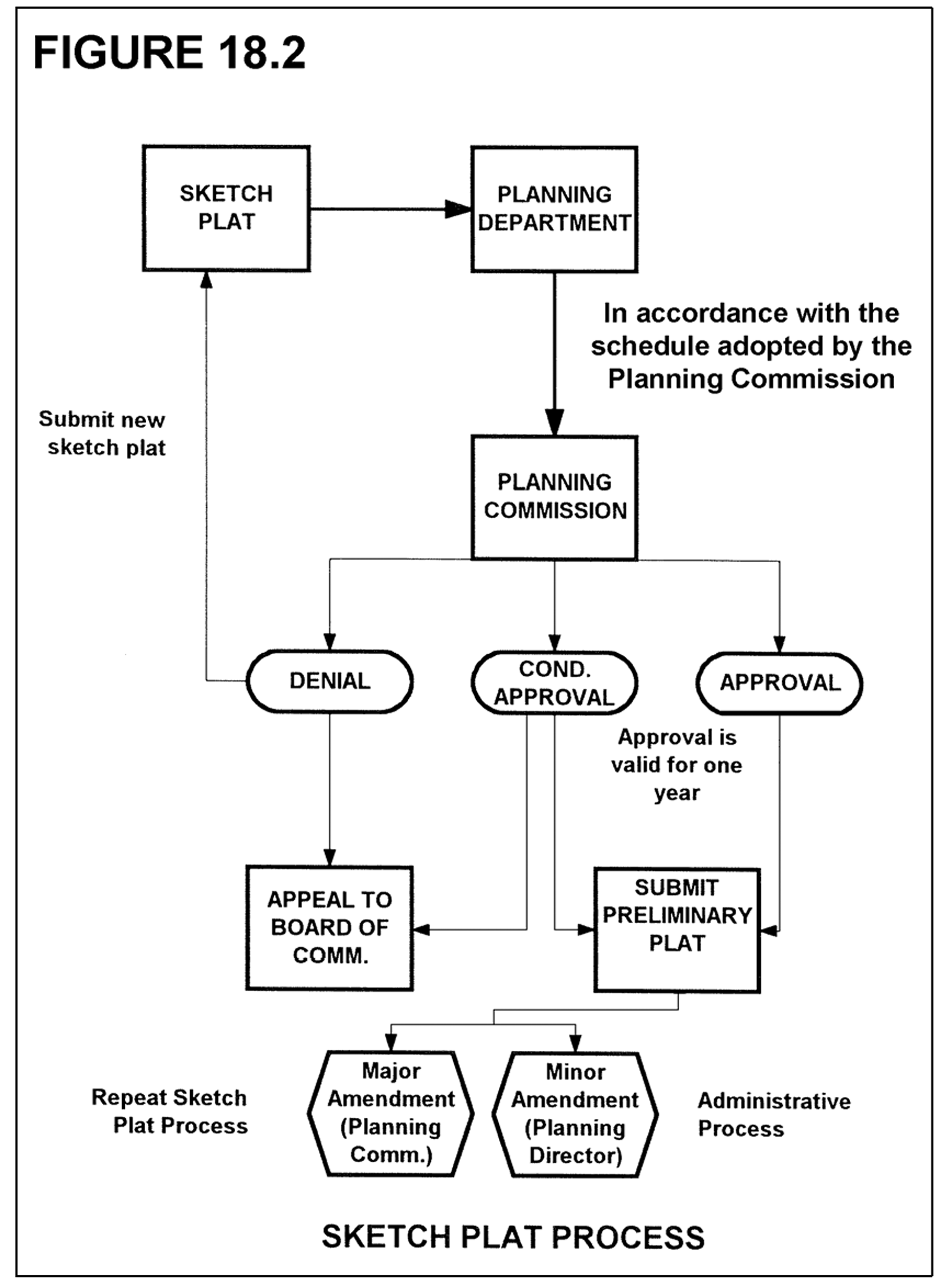
18-6.2. - Sketch plat.
Sketch plat purpose, requirements and procedures are addressed in chapter 8 of this Code.
(Amd. F of 5-12-2003; Amd. of 2-2-2004; Amd. of 11-15-2004; Amd. of 11-1-2007)
18-6.3. - Construction plans.
(a)
Application. Upon approval of a sketch plat, the subdivider or land developer may apply for construction plans approval. In the case of a minor subdivision, or in cases where a sketch plat is not required by this article, the subdivider or land developer may apply for approval of construction plans; provided, however, that in the case of a minor subdivision or land development the applicant for construction plan approval should hold a pre-application conference with the department to ensure that plans meet the intent and specific provisions of this Code. The construction plan approval process is administrative. Applications for construction plan approval shall be made in accordance with requirements shown in Table 18.1 and 18.2. No application for a construction plan shall be accepted for processing or approved by the director until a sketch plat, if required, has been approved and the proposed construction plans are found by the director to substantially conform with said approval and any conditions of such approval.
(b)
Director's decision criteria. The only basis upon which the director may deny a construction plan is the failure of the application to meet the requirements of this Code or any other applicable Forsyth County Ordinance or the failure of the construction plans and application to meet the requirements of sketch plat approval specified by the planning commission.
(c)
Certificate of approval. All copies of the construction plans shall be noted by inscription on the plat as follows:
"Pursuant to the Unified Development Code of Forsyth County, Georgia, and all requirements of approval having been fulfilled, these construction plans have been given approval by all Reviewing Departments, with final approval by the Director, or a designee of the Planning & Community Development Department, the issuing authority for Forsyth County. Construction plan approval does not constitute approval of a final plat, if required, and does not entitle this plat and plans to recordation in the Clerk's Office, Forsyth County Superior Court. The certificate of construction plan approval shall expire and be null and void one year from the date of the Planning & Community Development Department approval stamp as found on the cover sheet of these plans."
(d)
Certificate expiration. The Planning & Community Development Department stamp of approval on construction plans shall certify that the plans are approved, but such stamp shall not constitute approval of a final plat, if required. In the case of a subdivision, it indicates only the layout has been approved as a guide to the preparation of final plat, and that improvements are authorized to be constructed. Construction plan approval shall expire and be null and void one year from the date of Planning & Community Development Department approval stamp as found on the cover sheet of said plans, unless activity toward improvement upon the land has been initiated, or unless an extension of time is approved by the department.
(Amd. of 2-2-2004; Amd. of 11-1-2007; Amd. of 12-1-2011; Amd. of 5-3-2018)
18-6.4. - Final plat.
(a)
When required. All major and minor subdivisions shall require final plat approval. The final plat approval process is administrative. Applications shall be made in accordance with requirements shown in Table 18.1.
(b)
Criteria for approval. The director of planning and community development may grant final plat approval if the following conditions are met:
(1)
A sketch plat of the proposed subdivision has been previously officially approved by the county when required.
(2)
Construction plans have been approved by the director.
(3)
All improvements have been installed and inspected by the director of engineering, or adequate provisions have been made to guarantee such improvements. The Forsyth County and/or City of Cumming Water and Sewer Department must approve utility construction prior to the approval of the final plat.
(4)
The final plat meets all applicable requirements of this Code.
(5)
A complete final plat application has been submitted, including all supporting materials required by this chapter for final plats.
(6)
If a final plat has not been approved within one year of initial submittal, the application for final plat approval is null and void. The final plat must be resubmitted and the applicant must pay a resubmittal fee.
(7)
In residential developments, any amenities area must be permitted and under construction before the issuance of a final plat.
Final plats and applications that meet the above-referenced conditions shall be considered a ministerial action of approval by the director of planning and community development. Denial of a final plat shall be permitted only upon specific findings that one or more of the above-referenced conditions have not been met.
(c)
Approval certificate. Upon approval of the final plat, a certificate, stamped directly on the plat, shall state:
"Pursuant to the Unified Development Code of Forsyth County, Georgia, and all requirements of approval having been fulfilled, this final plat was given approval by all Reviewing Departments, with final approval by the Director, or a designee of the Planning & Development Department, the issuing authority for Forsyth County. This final plat is entitled to recordation in the Clerk's Office, Forsyth County Superior Court, on or after the date as indicated on the Planning & Development Department approval stamp as found on the cover sheet of these plans."
(d)
Additional plat specifications. Per those requirements identified in Table 18.1 and 18.2 to be supplied on a final plat, each major subdivision final plat - and all minor subdivision plats when deemed necessary by the county engineer - shall contain certificates in the following form:
(1)
Surveyor's certificate. A certificate by a surveyor directly on the applicable plat as follows:
"It is hereby certified that all monuments and improvements shown hereon actually exist except as otherwise indicated and that their location, size, type and material are correctly shown.
By: _____
Registered Georgia Land Surveyor No.: _____ "
(2)
Owner's certificate. A certificate by the owner directly on the applicable plat, signed in an appropriate manner as follows:
"The owner certifies that all state and local taxes and other assessments that have been billed for collection by the pertinent taxing authority have been paid. The owner donates and dedicates to the public for use forever the public street right-of-way as shown on this plat.
_____
Owner
Signed, sealed and delivered in the presence of:
_____
Witness
_____
Notary Public"
(Amd. of 2-2-2004; Amd. of 11-15-2004; Amd. of 11-1-2007; Amd. of 12-1-2011; Amd. of 4-2-2015; Amd. of 10-1-2015)
18-7.1. - Flag lots.
Flag lots within minor subdivisions shall be permitted, provided that flag lots within a minor subdivision shall meet the minimum access requirements as specified by this Code. At no point may the staff or "pole" portion of a flag lot be less than 60 feet in width. Minor subdivisions may contain more than one flag lot, however flag lots may not adjoin each other or share common property lines. This provision shall not be construed to prohibit the approval of two contiguous flag lots in separate minor subdivisions under separate ownership. Under no circumstances may two flag staffs or "poles" be contiguous.
(Amd. of 3-26-2001; Amd. of 2-2-2004)
18-7.2. - Access.
A maximum of three lots within a minor subdivision may fail to abut a public road or street only in an instance where the subdivider provides access to said individual lot over and across a valid easement containing a minimum width of 20 feet. The location and dimensions of such access shall be shown upon the minor subdivision plat and clearly identified as an easement and shall only be used for a maximum of three parcels, whether previously platted or newly created under the terms of this chapter. In instances where a minor subdivision contains such lots that do not abut a public road, the final plat of the minor subdivision shall also contain the following owner's certificate:
"I, the undersigned owner hereby dedicate the access easement shown on this plat to the common use of the owner, or owners, of the lot within this subdivision. It is further acknowledged that the accessway and any improvements within such access easement shall not be accepted by Forsyth County, Georgia, but shall remain privately owned and maintained.
_____
Owner
Signed, sealed and delivered in the presence of:
_____
Witness
_____
Notary Public"
(Amd. of 2-2-2004; Amd. of 11-15-2004)
18-7.3. - Limitations on minor subdivisions.
(a)
Purpose. Minor subdivisions provide certain advantages that tend to favor their use over the filing of major subdivision applications. Said advantages include a shorter application period and approval process, less public scrutiny, and less rigorous requirements for access to three of the lots in a minor subdivision. Given these advantages, the prospect exists that subdividers may seek to divide a parcel via consecutive and/or contiguous minor subdivisions instead of filing for a major subdivision. It is the intent of the board of commissioners to prohibit the practice of "chain" subdivisions where the same land owner subdivides land and then files minor subdivision applications on contiguous common parcels, which collectively total seven or more lots. It is also the intent of the board of commissioners to prohibit minor subdivisions adjacent to each other within a three-year time period, in cases where part of an original tract of land is now owned by another person or entity and was transferred or sold to another owner with the apparent intent to circumvent the major subdivision process.
(b)
Contiguous common parcels, as defined by this Code, shall be referenced on all applications for minor subdivisions and contiguous common parcels shall be considered part of any application for minor subdivision, for purposes of determining whether or not the division of land proposed is a major subdivision or a minor subdivision. Contiguous common parcels shall not be counted as lots in the case of a minor subdivision.
(c)
Land within a minor subdivision, including all contiguous parcels owned by the subdivider, shall not be further divided for a period of three years unless a sketch plat application is filed and approved as a major subdivision pursuant to the requirements of this chapter.
(d)
If property proposed to be subdivided was part of an original tract, and if the property proposed to be subdivided abuts land that has been divided as a minor subdivision in the last three years, then minor subdivision of said property shall be prohibited. This provision shall not be construed to prohibit the approval of two contiguous minor subdivisions under separate ownership; however, this provision is intended to be construed liberally so that one property owner does not develop a minor subdivision on part of an original tract and transfer or sell another part of the original tract for the purposes of minor subdivision within a three year period. It is the intent that land abutting a minor subdivision that was owned by the subdivider of the abutting minor subdivision shall not be subdivided as a minor subdivision for a period of three years, regardless of ownership.
(Added 11-1-2007)
18-8.1. - Eligibility.
A land subdivision shall qualify as an intrafamily subdivision plat if it meets the following requirements:
(a)
Each and every conveyance of a tract or parcel of land contained within the subdivision plan shall be an intra-family transfer to the children or the spouse and children of the grantor or surviving heirs of deceased children of the grantor.
(b)
No consideration shall pass from the grantees to the grantors other than love and affection. Transfers for money, tangible or intangible personal property, real property exchanges, or other conveyances for consideration are excluded.
(c)
The provisions of this article shall be available only for minor subdivisions.
(d)
The provisions of this article shall apply only to simultaneous transfers of tracts or parcels of land and all platted parcels shall be immediately transferred with recording of the deeds simultaneously with the final subdivision plat.
(e)
The proposed subdivision must meet all requirements of this Code.
(f)
No grantee shall receive more than one approved parcel.
(Amd. of 2-2-2004)
18-8.2. - Plat and procedural requirements.
To be eligible for approval, the following requirements shall be met:
(a)
The proposed subdivision must contain only lots which are one acre or greater in area, unless a variance is obtained.
(b)
Each subdivided parcel shall be substantially equal in area as topography permits.
(c)
A plat of the proposed subdivision shall be presented for approval to the planning commission.
(d)
An easement for ingress and egress, minimum 60 feet wide at all points, shall be shown on the plat running from a public road maintained by the State of Georgia, the Political Subdivision of Forsyth County or the City of Cumming to each divided tract or parcel. If such easement runs across lands of persons other than those owned by the proposed grantor(s), reference must be given on the subdivision plat to the place of recording of the deed granting the 60-foot easement across the property of such other person(s). The easement shall be owned by the grantees in fee simple as tenants in common.
(e)
The plat must contain thereon a notation as follows:
"The easement shown on this plat is for the exclusive use of the approved lots _______ shown. No other property shall be allowed to use the easement for ingress and egress until the easement meets County standards and is accepted by the governing authority. The approved lots shall not be further subdivided until such acceptance or upon the grant of variance pursuant to regulations. The property owner(s) shall be required to bring said easement and the travel way within the easement up to County standards prior to the dedication of the right-of-way and acceptance of maintenance by the County."
(f)
The name of each grantee shall be shown on each tract created.
(g)
The 60-foot easement shall traverse the tracts or parcels to be conveyed contiguous to the boundaries thereof and shall not divide a single tract or parcel.
(h)
All deeds, affidavits, and costs for recording shall be submitted to the planning and community development department at the same time the final plat is presented for approval.
(i)
The platted easement shall be cleared of trees and brush for safety purposes along the centerline thereof to a minimum width of 30 feet with an installed traveled surface in the center of such 30-foot strip, such installed traveled surface to be graded to a minimum width of 22 feet with adequate drainage provided to prevent flooding of the roadbed. All tracts or parcels shall use this right-of-way for ingress and egress to the publicly maintained road.
(j)
The 60-foot easement shall show two ten-foot wide strips within such right-of-way and contiguous to the boundaries thereof within which all utility installations serving the parcels shall be placed.
(k)
The subdivision plat shall contain thereon, in addition to other notations required by this chapter for final plats, a notation that "no warranty deed, quit-claim deed, executor's or administrator's deed or assent to devise, or other transfer of any interest in the property shall be executed or recorded transferring any tract or parcel, or portions thereof, unless such division has been specifically approved by the planning commission.
(l)
An affidavit, signed by all grantors and grantees in a form approved by the county attorney, stating that no consideration for the transfer of the properties shall pass other than love and affection, shall be filed with the department of planning and community development.
(Amd. of 2-2-2004; Amd. of 12-1-2011)
18-9.1. - Private streets permitted.
Notwithstanding other provisions of this chapter (section 18-2.4(a) and section 18-3.1(a)), private streets may upon application be permitted by the board of commissioners within major subdivisions, subject to the requirements of this article. Applications for approval of private streets shall be considered by the board of commissioners. The board of commissioners may impose conditions on the approval of private streets to ensure the health, safety and welfare of the general public and to mitigate potential problems with private streets.
Notwithstanding other provisions of this chapter (section 18-2.4(a) and section 18-3.1(a)), a private street may be permitted as part of a subdivision containing six or fewer lots on lands zoned A1 and LR, without the specific approval of the board of commissioners, as a major subdivision, subject to the requirements of this article; provided, however, that no more than six lots shall be served by any individual private street pursuant to this provision.
A private streets shall not be permitted or approved pursuant to this article when it is proposed in a location shown on the county's official map as a future public street or on the County's major thoroughfare plan as a public street.
(Amd. F of 5-12-2003; Amd. of 2-2-2004)
18-9.2. - General provisions.
(a)
It shall be unlawful for any person, firm, or corporation to construct a new private street or alter an existing private street or to cause the same to be done without first obtaining a land disturbance permit for such construction or alteration from the department.
(b)
It shall be unlawful for more than six lots to be served by a private street, except as may be specifically approved by the board of commissioners as provided in section 18-9.1.
(c)
All private streets shall be constructed to all standards for public streets as required by this Code, construction specifications of the county engineering department, and the director of engineering. No land disturbance permit for a private street shall be issued unless the proposed street is in conformity with county standards and requirements for public streets and the provisions of this Code.
(d)
No final plat involving a private street shall be approved unless said final plat conforms to the requirements of this chapter.
(e)
All provisions of this chapter regarding public streets, including the design, submittal of plans, required improvements, etc., shall apply to all private streets approved pursuant to this article.
(Amd. of 2-2-2004)
18-9.3. - Street names and easements for private streets.
Private streets shall be named. The subdivider of land involving a public street shall install street signs with content containing the street name and the designation "private," as approved by the director of engineering. Easements for private streets shall be designated on final plats as general purpose public access and utility easements, along with the name of said private street. Said easement shall at minimum be of the same width as that required for the right-of-way of a public street by the major thoroughfare plan and the director of engineering for the type of public street (local, collector, etc.) most closely resembling the proposed private street. Easements for private streets shall not be included in any calculation of minimum lot size or density limitations established by this Code. In the cases of private streets serving six lots or less, the general purpose public access and utility easement for the private street shall be shown in a manner on the final plat such that each lot fronting the private street extends to the centerline of the private street. No lot shall be permitted to be divided by the general purpose public access and utility easement required and established for a private street. In the cases of private streets serving seven or more lots, the general purpose public access and utility easement for a private street shall be drawn as its own discrete parcel to be dedicated to a private homeowners association (i.e., not shown to be a part of any lot).
(Amd. of 3-26-2001; Amd. of 2-2-2004)
18-9.4. - Maintenance.
The county shall not maintain, repair, resurface, rebuild, or otherwise improve streets, signs, drainage improvements or any other appurtenances within general purpose public access and utility easements established for private streets. A private maintenance covenant recorded with the County Clerk of the Superior Court shall be required for any private street and other improvements within general purpose public access and utility easements established for private streets. The covenant shall set out the distribution of expenses, remedies for non-compliance with the terms of the agreement, rights to the use of easements, and other pertinent considerations. The covenant shall specifically include the following terms:
(a)
The covenant shall establish minimum annual assessments in an amount adequate to defray costs of ordinary maintenance and procedures for approval of additional needed assessments. The covenant shall also specify that the funds from such assessments will be held by a homeowners or property owners association in cases of a subdivision fronting on a private street.
(b)
The covenant shall include a periodic maintenance schedule.
(c)
The covenant for maintenance shall be enforceable by any property owner served by the private street.
(d)
The covenant shall establish a formula for assessing maintenance and repair costs equitably to property owners served by the private street.
(e)
The covenant shall run with the land.
(f)
The board of commissioners may, at its discretion, as a condition of approving private streets, require a performance bond and/or maintenance bond be submitted by the subdivider and held by a homeowners or property owners association, or the board may require that the subdivider pay an amount of money as recommended by the director of engineering into an escrow account or other suitable account for the maintenance and repair of private streets and stormwater management improvements, to be drawn from by the homeowners or property owners association as maintenance and repair needs may arise.
(g)
The subdivider/developer shall provide to the county an acceptable form of financial security to guarantee the repair and maintenance of public water and sewerage improvements and utilities, including, but not limited to water lines, sewer lines, pump stations, force mains, and lift stations. The subdivider's or developer's financial guarantee, whichever is applicable, may be any of the following on a form required by or acceptable to the county: (1) An escrow of funds with the county; or (2) A maintenance bond for the benefit of the county upon which the county can collect. The financial guarantee shall be in an amount to secure the full costs, as determined by the director of water and sewer, of maintaining and repairing said improvements and utilities for a period ending upon the later of the county's issuance of a release letter regarding the bond or 18 months after recording of the county approved final plat for the subdivision, or subdivision phase, as the case may be. The previous sentence notwithstanding, in no event will the financial guarantee extend for longer than 36 months. To the extent no release letter has been issued by the county within 36 months of the guarantee being issued, the guarantee shall be deemed to automatically expire at the expiration of the 36-month.
(Amd. of 2-2-2004; Ord. of 3-3-2016(1))
18-9.5. - Specifications for final plats involving private streets.
No final plat involving a private street shall be approved by the department for recording unless and until it shall contain the following on the face of the plat:
(a)
Deed book and page reference to the recorded covenant required in section 18-9.4 above.
(b)
"WARNING, Forsyth County has no responsibility to build, improve, maintain, or otherwise service the private streets, drainage improvements, and other appurtenances contained within the general public purpose access and utility easement or easements for private streets shown on this plat."
(c)
"Grant of Easement. The general purpose public access and utility easement(s) shown on this plat for private street(s) is hereby granted and said grant of rights shall be liberally construed to provide all necessary authority to the County, and to public or private utility companies serving the subdivision, for the installation and maintenance of utilities, including, but not limited to electric lines, gas lines, telephone lines, water lines, sewer lines, cable television lines, and fiber optic cables, together with the right to trim interfering trees and brush, together with a perpetual right of ingress and egress for installation, maintenance, and replacement of such lines.
Signature of Property Owner"
(d)
The following certificate of dedication shall be required, unless the board of commissioners or other authorized representative of Forsyth County waives the dedication requirement.
"Certificate of Dedication. All water and sewer lines installed within the general purpose public access and utility easement(s) shown on this plat for private street(s) are hereby dedicated to Forsyth County.
Signature of Property Owner"
(Amd. of 2-2-2004)
18-9.6. - Requirement for purchaser's acknowledgement of private responsibilities.
Prior to the sale or as a condition of the closing of a real estate transaction involving any lot served by a private street in Forsyth County, the subdivider or seller of said lot shall execute a notarized purchaser's acknowledgement of private street construction and drainage maintenance responsibilities set forth below. A copy of the purchaser's acknowledgement shall be retained by the purchaser and shall be required to be submitted as a condition of a building permit for a principal building on said lot:
"Purchaser's Acknowledgement of Private Street and Drainage Maintenance Responsibility.
(I) (We) have read the Declaration of Covenant which pertains to the lot that is the subject of this real estate transaction _______ (insert address or attach legal description). (I) (We) understand that the Declaration of Covenant applies to the lot that (I am) (we are) purchasing and requires (me) (us) to provide a specified percentage or amount of the financing for the construction and maintenance of any private street and drainage facilities serving the lot which (I am) (we are) purchasing, and that owners of other lots in this plat may sue and recover for those costs which this covenant requires (me) (us) to pay, plus their damages resulting from (my) (our) refusal to contribute, plus reasonable attorneys fees. (I) (we) further understand that the County has no obligation to assist with the maintenance and improvement of the private street, drainage facilities, and other appurtenances within the general purpose public access and utility easement for the private road serving the lot in question. I (we) understand that a copy of this purchaser's acknowledgement shall be required as a condition of the issuance of a building permit for a principal building on the lot (I am) (we are) purchasing.
Purchaser
Purchaser"
(Amd. of 2-2-2004)
18-10.1. - Buffer protection requirements.
All undisturbed buffers (whether exterior buffers or stream buffers or any other designation) shall be identified with orange, four-foot tree-save fencing prior land-disturbance. Tree-save fencing shall remain in place until issuance of certificate of occupancy or certificate of completion.
(Added 11-1-2007)
18-10.2. - Augmentation.
All buffers are required to be undisturbed, except as provided below. Undisturbed buffers shall be augmented, however, with plantings in order to satisfy requirements of the Forsyth County Buffer Standards if sparsely vegetated.
(Added 11-1-2007)
18-10.3. - Prohibited encroachments.
Prohibited buffer encroachments include, but are not limited to, buildings, pavement, parking, service areas, detention ponds, roads, septic tanks, septic drain fields, and walls, unless otherwise specified in section 18-11. A buffer may be disturbed for approved access and utility crossings including, but not limited to, water and sewer lines, drainage pipes, and gas lines provided that it does so via a perpendicular crossing that does not run parallel within the buffer. An exception to a perpendicular crossing restriction may be requested for side and rear buffers. In addition, the removal of non-native, invasive species is allowed within zoning buffers at the discretion of the county arborist. If a required buffer cannot provide a visually impervious screen, it shall be supplemented with additional plantings as specified in the Forsyth County Buffer Standards. Specific buffer types are defined below.
(Added 11-1-2007 Amd. of 11-11-2012; Amd. of 8-12-2021)
18-10.4. - Buffer measurement.
The specified width of a buffer is measured as extending along the entire portion of the common property line and from the common property line extending into the interior of the subject parcel.
(Added 11-1-2007)
18-10.5. - Buffer controls by type.
The following regulations are found in various chapters of this Code, including Chapter 10 General Provisions, Chapter 16 Supplementary Regulations and Chapters 11, 12, 14 regulating Zoning Districts. For convenience, these regulations are itemized here.
(A)
Residential Exterior. The exterior buffer required by Chapter 11 for some residential developments may be disturbed for grading and/or development of a site.
(B)
Georgia Highway 400 - Limited Access (Fulton County to SR 369 right-of-way). The required buffer shall meet the requirements of the Forsyth County Buffer standards to achieve a visual screen.
(C)
Large Scale Retail. The buffer required along property lines abutting residential, agricultural or OR zoning district shall remain undisturbed.
(D)
Stream Buffer. See Section 18-11.
(E)
Side and rear yard zoning district requirements. The buffer required along property lines abutting residential, agricultural or OR zoning districts may disturbed and replanted when site conditions dictate, as documented by the engineer of record and as permitted by the director of planning and/or engineering. Specifically, such disturbance may occur only in instances where erosion control issues, stormwater management methods (excluding structural stormwater control practices), topography, and/or the installation of water and sewer lines require clearing and/or grading. In regards to utility crossings, in instances where the line must run parallel within the buffer, compliance with the Forsyth County Buffer Standards must be met; said easement cannot reduce the minimum planting requirement or width of the required buffer. All disturbed buffers must comprise of one extra row of plantings in addition to the minimum requirements as indicated in the Forsyth County Buffer Standards prior to final site approval.
(Added 11-1-2007; Amd. of 11-11-2012; Amd. of 1-3-2013)
18-11.1. - Applicability.
The provisions of this article shall apply to all land development activity on property containing state waters as defined in chapter 3 of this Unified Development Code. These requirements are in addition to, and do not supersede, any applicable buffer requirements established under state law, and approval under or exemption from the requirements of this article does not constitute approval under or exemption from buffer requirements established under state law or from other applicable local, state or federal regulations.
(a)
The requirements of this article shall not apply to the following activities:
(1)
Work consisting of the repair or maintenance of any lawful use of land that is zoned and approved for such use on or before the effective date of this article.
(2)
Existing agriculture, silviculture, landscaping, gardening and lawn maintenance.
(3)
Any land development activity that is under construction, permitted for development, or has been submitted for approval as of the effective date of this article.
(4)
Multi-phased land-disturbance activities. With respect to the applicability of this article, a grace period shall exist for multi-phased developments (whether for office parks, master-planned communities or otherwise identified multi-phase developments) for which any of the following exist prior to the effective date of this article:
a.
Initial phases have already been permitted; or
b.
A site plan had been approved through the sketch plat process showing an alternate stream buffer; or
c.
An approval for zoning included conditioning the property to a specific site-plan, provided that the approval date preceded November 14, 2004.
For such developments, discrete phases that have not been submitted for permit approval as of the effective date of this article shall be allowed two years to do so and shall be allowed to utilize the previous stream requirements identified on their site plans or zoning condition. Permit applications submitted more than two years after the effective date of this article, however, shall meet the buffer and setback requirements herein.
(b)
Exemptions. The following specific activities are exempt from this article. Exemption of these activities does not constitute an exemption for any other activity proposed on a property.
(1)
Activities for the purpose of building the following:
a.
A stream crossing by a driveway, transportation route or utility line;
b.
Water and sewer utility lines and pumping stations, provided that the director of water and sewer determines that the buffer is the best location for such facilities;
c.
Public water supply intake or public wastewater outfall structures;
d.
Intrusions necessary to provide access to a property;
e.
Public access facilities that must be on the water including boat ramps, docks, foot trails leading directly to the river, fishing platforms and overlooks;
f.
Unpaved foot trails and paths; any paths or trails constructed and maintained by the county, and; any paths that connect to a county trail system, subject to approval by the county engineer.
g.
Activities to restore and enhance stream bank stability, vegetation, water quality and/or aquatic habitat, so long as native vegetation and bioengineering techniques are used.
h.
Water features designed specifically for stormwater best management practices, as determined by the director of engineering.
(2)
Public sewer line easements paralleling the creek, except that all easements (permanent and construction) and land disturbance should be at least 25 feet from the top of the bank. This includes such impervious cover as is necessary for the operation and maintenance of the utility, including but not limited to manholes, vents and valve structures. This exemption shall not be construed as allowing the construction of roads, bike paths or other transportation routes in such easements, regardless of paving material, except for access for the uses specifically cited in (1) above.
(3)
Authorized land development activities within a right-of-way.
(4)
Within an easement of any utility existing at the time this article takes effect or approved under the terms of this Unified Development Code, land disturbance activities and such impervious cover as is necessary for the operation and maintenance of the utility, including but not limited to manholes, vents and valve structures.
(5)
Emergency work necessary to preserve life or property. However, when emergency work is performed under this section, the person performing it shall report such work to the department of engineering on the next business day after commencement of the work. Within five days thereafter, the person shall apply for a permit and perform such work within such time period as may be determined by the department of engineering to be reasonably necessary to correct any impairment such emergency work may have caused to the water conveyance capacity, stability or water quality of the protection area.
(6)
Forestry and silviculture activities on land that is zoned for forestry, silvicultural or agricultural uses and are not incidental to other land development activity. If such activity results in land disturbance in the buffer that would otherwise be prohibited, then no other land disturbing activity other than normal forest management practices will be allowed on the entire property for three years after the end of the activities that intruded on the buffer.
(Added 11-1-2007)
18-11.2. - Stream buffer requirements.
All land development activity subject to this article shall meet the following requirements:
(a)
An undisturbed natural vegetative buffer shall be maintained for 50 feet, measured horizontally, on both banks (as applicable) of state waters as measured from the top of the bank.
(b)
An additional setback shall be maintained for 25 feet, measured horizontally, beyond the undisturbed natural vegetative buffer, wherein all impervious cover shall be prohibited, except for stormwater management facilities. Grading, filling and earthmoving shall be minimized within the setback; allowance for such activity shall consider needs for retaining walls and other topographical requirements as determined by the department of engineering.
(c)
No septic tanks or septic tank drain fields shall be permitted within the buffer.
(d)
Additional permit application requirements for developments on properties that contain state waters. Any permit application for property requiring buffers and setbacks hereunder must include the following:
(1)
A site plan showing:
a.
The location of all state waters on the property;
b.
Limits of required buffers and setbacks on the property;
c.
Buffer zone topography with contour lines at no greater than five-foot contour intervals;
d.
Delineation of forested and open areas in the buffer zone; and
e.
Detailed plans of all proposed land development in the buffer and of all proposed impervious cover within the setback, including documentation establishing a properly approved variance or qualifying exemption that would permit land disturbing activity within a buffer or setback;
(2)
A written description of any proposed land development within the buffer and setback; and
(3)
Any other documentation that the director of planning and community development or director of engineering may reasonably deem necessary for review of the application and to insure that the buffer zone regulation is addressed in the approval process. All buffer and setback areas must be recorded on the plat, final plat, or as-built of the property following plan approval.
(Added 11-1-2007; Amd. of 12-1-2011)
18-11.3. - Administration of stream buffer requirements.
(a)
Variance procedures. Variances from the above buffer and setback requirements may be granted in accordance with the following provisions:
(1)
Who considers variances. Variances under this section shall be reviewed as provided in chapter 8 of this Code and apply to those requested in conjunction with zoning application requests.
(2)
Public hearing. All applications for a stream buffer variance shall require a public hearing and notice as specified in the applicable provisions of chapter 8 of this Code.
(3)
Variances will be considered only in the following cases:
a.
When a property's shape, topography or other physical conditions existing at the time of the adoption of this article prevents land development unless a buffer variance is granted.
b.
Unusual circumstances wherein strict adherence to the minimal buffer requirements in this article would create an extraordinary hardship, as distinguished from a mere inconvenience.
Variances will not be considered when, following adoption of this article, actions of any property owner of a given property have created conditions of a hardship on that property.
(4)
At a minimum, a variance request shall include the following information:
a.
A site plan that includes locations of all streams, wetlands, floodplain boundaries and other natural features, as determined by field survey;
b.
A description of the shape, size, topography, slope, soils, vegetation and other physical characteristics of the property;
c.
A detailed site plan that shows the locations of all existing and proposed structures and other impervious cover, the limits of all existing and proposed land disturbance, both inside and outside the buffer and setback. The exact area of the buffer to be affected shall be accurately and clearly indicated;
d.
Documentation of the extraordinary hardship should the buffer be maintained;
e.
At least one alternative plan, which does not include a buffer or setback intrusion, or an explanation of why such a site plan is not possible;
f.
A calculation of the total area and length of the proposed intrusion;
g.
A stormwater management site plan, if applicable; and
h.
A buffer mitigation plan in accordance with the stream buffer mitigation checklist. Forsyth County acknowledges the beneficial functions of undisturbed stream buffers including: water quality protection, pollutant/runoff infiltration, maintenance of base flow water levels, erosion/sedimentation reduction, increased channel/bank stability, stream shading, support of aquatic and terrestrial wildlife habitats, and recreational/aesthetic value. To compensate for the lost stream buffer functions due to impacts, mitigation should revegetate, protect, and otherwise maintain and improve stream buffer functioning at the same site where the impact will occur.
(5)
Incomplete applications which fail to include the above information shall not be considered.
(6)
The department of engineering shall prepare and submit to the board considering the variance (zoning board of appeals, planning commission and/or board of commissioners) a technical comment on the applicant's mitigation measures, alternative designs and/or explanations of why an alternative plan is not possible.
(7)
The following criteria will be considered in determining whether to issue a variance:
a.
The shape, size, topography, slope, soils, vegetation and other physical characteristics of the property;
b.
The locations of all state waters and on the property, including along property boundaries;
c.
The location and extent of the proposed buffer or setback intrusion;
d.
Whether request is the minimum necessary to accomplish the proposed development and whether alternative designs are possible which require less intrusion or no intrusion;
e.
The long-term and construction water-quality impacts of the proposed variance;
f.
Whether issuance of the variance is at least as protective of natural resources and the environment.
(b)
Responsibility. Neither the issuance of a development permit nor compliance with the conditions thereof, nor with the provisions of this article shall relieve any person from any responsibility otherwise imposed by law for damage to persons or property; nor shall the issuance of any permit hereunder serve to impose any liability upon Forsyth County, its officers or employees, for injury or damage to persons or property.
(c)
Validity. Approvals are valid per section 8-6.4(c) of this Code.
(d)
Review of variance decisions. Applicants may petition the board of commissioners regarding variance decisions per chapter 8, article VIII of this Code.
(e)
Inspection. The director of engineering may cause inspections of the work in the buffer or setback to be made periodically during the course thereof and shall make a final inspection following completion of the work. The permittee shall assist the director of engineering in making such inspections. Forsyth County shall have the authority to conduct such investigations as it may reasonably deem necessary to carry out its duties as prescribed in this article, and for this purpose to enter at reasonable time upon any property, public or private, for the purpose of investigating and inspecting the sites of any land development activities within the protection area. No person shall refuse entry or access to any authorized representative or agent who requests entry for purposes of inspection, and who presents appropriate credentials, nor shall any person obstruct, hamper or interfere with any such representative while in the process of carrying out official duties.
(f)
Violations, enforcement and penalties. Any violation of the provisions of this article or the requirements of an approved site plan or permit may be subject to the enforcement actions detailed in chapter 22 of the UDC or Ordinance No. 73 (Soil and Sedimentation Control Ordinance), section VII, whichever shall result in the greater potential penalty to the offender. Any such action or inaction which is continuous with respect to time is deemed to be a public nuisance and may be abated by injunctive or other equitable relief.
(Added 11-1-2007)
18-12.1. - Applicability.
The provisions of this article shall apply to any land development activity within designated zoning districts as noted below. These requirements are in addition to any applicable buffer requirements established under state and local law.
(a)
Residential developments of at least 25 acres located within residential zoning districts shall adhere to the following:
(1)
An undisturbed area of separation shall exist between each contiguous area of disturbance as regulated by the Forsyth County Soil Sedimentation and Erosion Control Ordinance (Ordinance #73). The square footage of each undisturbed area of separation shall be calculated based on a minimum width of 50 feet as measured from the perimeter of each contiguous area of disturbance. The total square footage may then be designed and located in a manner that replicates a naturalistic shape, but such area shall not fall below a minimum width of 50 feet and the total square footage must adhere, at minimum, to the calculated square footage total and be placed between each contiguous area of disturbance.
(2)
An undisturbed area of separation may only be disturbed for streets, sidewalks, trails and access for utilities including but not limited to water and sewer lines, drainage pipes, and gas lines, via a perpendicular crossing as well as the removal of non-native, invasive species at the discretion of the county arborist.
(Amd. of 8-12-2021)
18-13.1. - Purpose and intent.
The provisions of this article are intended to incentivize aesthetically-enhanced, natural looking stormwater management facilities designed to function as accessible community amenities and runoff reduction measures that incorporate enhanced landscape design for community benefit.
(Amd. of 8-12-2021)
18-3.2. - Applicability.
The provisions of this article shall apply to open space requirements associated with any zoning district, but shall not pertain to conservation subdivisions as regulated by chapter 19.
(Amd. of 8-12-2021)
18-3.3. - Incentive requirements.
(a)
Approved design features noted below may be applied towards minimum open space requirements at two times the amount of square footage for non-residential zoning districts to include the master planned district (MPD) and one and a half times the amount of square footage for residential districts. Square footage calculations shall include those areas serving as a low-impact stormwater control feature and may also include community amenity elements such as pedestrian paths and seating located within and around such features.
(b)
Developments in any zoning district may incorporate the following low-impact stormwater design options within required open space upon county review and approval. Approval shall be granted provided the design satisfies the requirements of this article.
(1)
Stormwater ponds that have a minimum permanent pool of water as long as all of the following elements are incorporated:
(a)
Naturalized landscaping along gentle pond side slopes;
(b)
Fountain for aeration to maintain water quality;
(c)
No physical barriers around the pond perimeter;
(d)
Pedestrian, pervious path with seating is located around pond perimeter. Path system must provide safe and convenient connectivity from pond area to either a residential subdivision amenity area or non-residential, primary building entrance(s) and then to the public street network. Connections to amenity areas and building entrances may be impervious when part of a sidewalk or multi-use trail network within the development.
(2)
Incorporation of grass filter strips subject to the following:
(a)
Turf grass or similar groundcover is provided to filter out sediments and other pollutants from runoff;
(b)
Design shall be in accordance with the Georgia Stormwater Management Manual;
(c)
Routine mowing of filter strip shall be required for proper maintenance;
(d)
Filter strips may be located in required landscape strips.
(3)
Parking lot bioretention applications which may include the following:
(a)
Lot grading that is designed for sheet flow towards linear landscape areas and parking islands;
(b)
Curb-less pavement edges used to convey water into depressed parking islands or other landscape areas;
(c)
Parking lots that are graded so that flows reach a curb-less pavement edge or curb cut before reaching catch basins or storm drain inlets;
(d)
Turf grass at the edge of parking lots to serve as a grass filter strip when the depression for bioretention is located within a pervious area that is adjacent to the parking lot.
(4)
Courtyards utilized for collecting runoff from a storm drain system or roof leaders that may be directed to these areas or other pervious locations on site where bioretention may be installed.
(c)
Planting plans sealed by a registered landscape architect must be submitted for each bioretention area and shall include the following:
(1)
Delineation of planting areas including the size and species of all plant material;
(2)
Plant material shall be based on the goal of simulating a terrestrial, forested community of native species including grass and herbaceous ground covers, shrubs, and trees, which shall achieve surface area coverage of at least 75 percent within two years;
(3)
The proper selection and installation of plant materials is critical to the performance and function of bioretention areas and shall be based on guidelines found in appendix D, Georgia Stormwater Management Manual.
(d)
The engineering director may administratively approve an alternate low impact stormwater design where the proposed design satisfies the intent of this article at least as well as the designs identified in this article and the public health, safety and welfare is protected.
(Amd. of 8-12-2021)