
Forsyth County Unincorporated
City Zoning Code
City Zoning Code
CHAPTER 21
- OVERLAY DISTRICTS
ARTICLE II. - PROTECTED WATER SUPPLY WATERSHED OVERLAY DISTRICT[28]
Cross reference— Utilities, ch. 82.
ARTICLE XI. - BUFORD HIGHWAY OVERLAY DISTRICT[29]
Editor's note— An amendment adopted May 19, 2016, amended article XI in its entirety to read as herein set out. Former article XI, §§ 21-11.1—21-11.10, pertained to similar subject matter. See Code Comparative Table for complete derivation.
21-1.1. - Purpose.
The purpose of overlay districts established by chapter 9, article I of this Code is to conserve natural resources or realize development objectives without unduly disturbing the expectations for development allowed by the existing zoning district provisions applicable to particular properties. The existing zoning district provisions may properly regulate the relevant district, in general, but more specific and targeted provisions contained in an overlay district are needed to accomplish pressing land use objectives.
(Amd. of 11-15-2004)
21-1.2. - Applicability.
The provisions of this chapter are applicable to those parcels within unincorporated Forsyth County that have particular development constraints:
(a)
The protected water supply watershed overlays as designated in chapter 9 of this Code, consist of the land areas that drain to the public water supply intake or water supply reservoir. The boundaries of these overlays are defined by the ridge lines of the respective watersheds and the boundary of a radius of seven miles upstream of the respective public water supply intakes.
(b)
The protected groundwater recharge area overlay district, as designated in chapter 9, consist of all lands within the jurisdiction of Forsyth County, Georgia that are mapped as significant recharge areas by the Georgia Department of Natural Resources in Hydrologic Atlas 18, 1989 edition.
(c)
The Etowah River Corridor Protection District Overlay District, as designated in chapter 9, consist of all areas within 100 feet horizontally on both sides of the Etowah River, in Forsyth County.
(d)
Wetland protection district overlay districts, as designated in chapter 9, consist of all wetlands within the jurisdiction of Forsyth County.
(Res. of 6-21-2004)
21-2.1. - Minimum criteria for the Big Creek Small Water Supply Watershed.
(a)
Permitted uses for perennial stream corridors within a seven mile radius upstream of a governmentally owned public drinking water supply intake. All uses allowed in the underlying zoning districts as established by this Code except for those listed in prohibited uses below are permitted in the water supply watershed protection overlay district, subject to the following conditions and standards:
(1)
A buffer shall be maintained for a distance of 100 feet on both sides of the stream as measured from the stream banks.
(2)
No impervious surface shall be constructed within a 150-foot setback area on both sides of the stream as measured from the stream banks.
(3)
Septic tanks and septic tanks drainfields are prohibited in the setback areas of subsection (b) above.
(b)
Permitted uses for perennial stream corridors outside a seven mile radius upstream of a governmentally owned public drinking water supply intake. All uses allowed in the underlying zoning districts as established by this Code except for those listed in prohibited uses below are permitted in the water supply watershed protection overlay district, subject to the following conditions and standards:
(1)
A buffer shall be maintained for a distance of 50 feet on both sides of the stream as measured from the stream banks.
(2)
No impervious surface shall be constructed within a 75-foot setback area on both sides of the stream as measured from the stream banks.
(3)
Septic tanks and septic tanks drainfields are prohibited in the setback areas of subsection (b) above.
(c)
General criteria for the Big Creek Small Water Supply Watershed. The following criteria apply to all locations in a small water supply watershed:
(1)
New sanitary landfills are allowed only if they have synthetic liners and leachate collection systems.
(2)
New hazardous waste treatment or disposal facilities are prohibited.
(3)
The impervious surface area, including all public and private structures, utilities, or facilities, for that portion of the water supply watershed within unincorporated Forsyth County shall be limited to 25 percent, or existing use, whichever is greater. The impervious surface area requirement shall be calculated based upon that portion of the water supply watershed within unincorporated Forsyth County; discrete parcels or projects will not be required to independently satisfy the impervious surface area limitations set forth above.
a.
Alternative criteria that provides equal or better protection of the water supply watershed shall also be acceptable if approved by Georgia Environmental Protection Division (EPD).
(4)
New facilities which handle hazardous materials of the types listed in Section 312 of the Resource Conservation and Recovery Act of 1976 (excluding underground storage tanks), and amounts of 10,000 pounds on any one day or more, shall perform their operations on impervious surfaces in conformance with any applicable federal spill prevention requirements or the requirements of the standard fire prevention code.
(d)
Exemptions.
(1)
Land uses established prior to the promulgation of the water supply watershed protection plan.
(2)
Mining activities permitted by the department of natural resources under the Surface Mining Act.
(3)
Utilities are exempt from the stream corridor buffer and setback area provisions of the water supply watershed protection plan if the utilities to be located in the buffer or setback areas cannot feasibly be located outside these areas;
a.
The utilities shall be located as far from the stream bank as reasonably possible.
b.
The installation and maintenance of the utilities shall be such to protect the integrity of the buffer and setback areas as best as reasonably possible.
c.
The utilities shall not impair the quality of the drinking water stream.
(4)
Forestry and agricultural activities are exempt from the stream corridor buffer and setback area provisions of water supply watershed protection plans in accordance with the following conditions:
a.
The activity shall be consistent with best management practices established by the Georgia Forestry Commission or the Georgia Department of Agriculture.
b.
The activity shall not impair the quality of the drinking water stream.
(Amd. of 7-1-2010)
21-2.2. - Minimum criteria for the Etowah and Upper Chattahoochee Large Water Supply Watersheds.
(a)
A large water supply watershed has 100 square miles or more of land within the drainage basin upstream of a governmentally owned public drinking water supply intake.
(b)
The corridors of all perennial streams in a large water supply watershed tributary to a water supply reservoir within a seven-mile radius of the reservoir boundary are protected by the following criteria:
(1)
A buffer shall be maintained for a distance of 100 feet on both sides of the stream as measured from the stream banks.
(2)
No impervious surface shall be constructed within a 150-foot setback area on both sides of the stream as measured from the stream banks.
(3)
Septic tanks and septic tank drainfields are prohibited in the setback area of (2) above.
(c)
New facilities, located within seven miles of a water supply intake or water supply reservoir, which handle hazardous materials of the types listed in Section 312 of the Resource Conservation and Recovery Act of 1976 (excluding underground storage tanks) and amounts of 10,000 pounds on any one day or more, shall perform their operations on impervious surfaces and in conformance with any applicable federal spill prevention requirements or the requirements of the Standard Fire Prevention Code.
(d)
New facilities located outside the seven-mile radius that handle hazardous materials shall perform their operations on impermeable surfaces having spill and leak collection systems as prescribed by the department of natural resources.
21-3.1. - Permitted uses.
All uses allowed in the underlying zoning districts as established by this Code except for those listed in prohibited uses below are permitted in a protected groundwater recharge area overlay district subject to the following conditions and standards:
(a)
The department of natural resources shall not issue any permits for new sanitary landfills not having synthetic liners and leachate collection systems.
(b)
The department of natural resources shall not issue any new permits for the land disposal of hazardous wastes.
(c)
The department of natural resources shall require all new facilities permitted or to be permitted to treat, store, or dispose of hazardous waste to perform such operations on an impermeable pad having a spill and leak collection system.
(c)
New above-ground chemical or petroleum storage tanks, having a minimum volume of 660 gallons, shall have secondary containment for 110 percent of the volume of such tanks or 110 percent of the volume of the largest tank in a cluster of tanks. (Note: These figures are consistent with US EPA rules for oil pollution prevention, 40 CFR 112.1.) Such tanks used for agricultural purposes are exempt, provided they comply with all federal requirements.
(e)
New agricultural waste impoundment sites shall be lined if they are within:
(1)
A high pollution susceptibility area;
(2)
A medium pollution susceptibility area and exceed 15 acre-feet;
(3)
A low pollution susceptibility area and exceed 50 acre-feet.
As a minimum, the liner shall be constructed of compacted clay having a thickness of one-foot and a vertical hydraulic conductivity of less than 5 × 10⁻⁷ cm/sec or other criteria established by the U.S. Soil Conservation Service; the Georgia Department of Natural Resources, Environmental Protection Division; and/or Forsyth County. (The average size of existing agricultural waste impoundments in Georgia is about 15 acre-feet; sheeps-foot rollers or pans with heavy rubber tires, which are normal equipment for most Georgia earth moving contractors, should be able to compact clay to the recommended vertical hydraulic conductivity.)
(f)
New homes served by septic tank/drain field systems shall be on lots having the following minimum size limitations as identified on Table MT-1 of the Department of Human Resources' Manual for On-Site Sewage Management Systems (hereinafter "DHR Table MT-1"):
(1)
One hundred fifty percent of the subdivision minimum lot size of DHR Table MT-1 if they are within a high pollution susceptibility area; and
(2)
One hundred twenty-five percent of the subdivision minimum lot size of DHR Table MT-1 if they are within a medium pollution susceptibility area; and
(3)
One hundred ten percent of the subdivision minimum lot size of DHR Table MT-1 if they are within a low pollution susceptibility area.
(g)
New manufactured/mobile home parks served by septic tank/drain field systems shall have lots or spaces having the following size limitation as identified on Table MT-2 of the Department of Human Resources' Manual for On-Site Sewage Management Systems (hereinafter "DHR Table MT-2):
(1)
One hundred fifty percent of the subdivision minimum lot or space size of DHR Table MT-2 if they are within a high pollution susceptibility area; and
(2)
One hundred twenty-five percent of the subdivision minimum lot or space size of DHR Table MT-2 if they are within a medium pollution susceptibility area, and
(3)
One hundred ten percent of the subdivision minimum lot or space size of DHR Table MT-2 if they are within a low pollution susceptibility area.
(h)
If Forsyth County requires a larger lot size than that required by (f) above for homes or by (g) above for manufactured/mobile homes, the larger lot size shall be used.
(i)
No construction may proceed on a building or manufactured/mobile home to be served by a septic tank unless the Forsyth County Health Department first approves the proposed septic tank installation as meeting the requirements of the DHR Manual and (f), (g), and (h) above.
(j)
New facilities which handle hazardous materials of the types listed in Section 312 of the Resource Conservation and Recovery Act of 1976 (excluding underground storage tanks), in amounts of 10,000 pounds on any one day or more, shall perform their operations on impervious surfaces in conformance with any applicable federal spill prevention requirements or the requirements of the standard fire prevention code.
(k)
The department of natural resources shall require conservative design in any new permits for the spray irrigation of waste waters or the land spreading of waste water sludges in areas having high pollution susceptibility. This shall be accomplished by comparing the department's CRITERIA FOR SLOW RATE LAND TREATMENT (February, 1986 or latest edition) with amendments and other technical publications to site specific information submitted by a registered professional engineer for each project.
(l)
Permanent storm water infiltration basins shall not be constructed in areas having high pollution susceptibility.
(m)
Exclusive of mining settling basins, new waste water treatment basins shall have an impermeable liner in areas having high pollution susceptibility.
(Amd. of 2-7-2013)
21-3.2. - Exemptions.
Any lot of record on or before February 14, 2000 is exempt from the lot requirements of section 21-3.1(f) and (g) above.
21-4.1. - Permitted uses.
All uses allowed in the underlying zoning districts as established by this Code except for those listed in prohibited uses below are permitted in the Etowah River Corridor Protection District Overlay, subject to the following conditions and standards:
(a)
Standards and requirements established in the Metropolitan River Protection Act and the Erosion and Sedimentation Act are not superseded by the Etowah River Corridor Protection District standards.
(b)
Protection criteria:
(1)
The Etowah River Corridor Protection District shall provide for the maintenance of a natural vegetative buffer except as otherwise provided herein.
(2)
The Etowah River Corridor Protection District shall not prohibit the building of single family dwellings, including the usual appurtenances, within the buffer area, subject to the following conditions:
a.
The dwelling shall be in compliance with all Forsyth County zoning regulations.
b.
The dwelling shall be located on a tract of land containing at least two acres. For the purpose of these standards, the size of the tract of land shall not include any area that lies within the protected river (that is, for tracts of land that include portions of a protected river, the area between the river banks can not be counted towards the two acre minimum size).
c.
There shall be only one such dwelling on each two-acre or larger tract of land.
d.
A septic tank or tanks serving such a dwelling may be located within the buffer area.
e.
Septic tank drainfields shall not be located within the buffer area.
(c)
Within the Etowah River Corridor Protection District, industrial and commercial land uses existing prior to the promulgation of the Etowah River Corridor Protection District are exempt from these criteria provided that:
(1)
Industrial and commercial uses of river corridors shall not impair the drinking quality of the river; and
(2)
Industrial and commercial activity within the river corridor shall meet all state and federal environmental rules and regulations.
(d)
Except as expressly provided for under section 20A-4.1(b) of these criteria (dealing with single family dwellings within the Etowah River Corridor Protection District), septic tanks and septic tank drainfields are prohibited within river corridors.
(e)
The Etowah River Protection District shall provide for the construction of road crossings and utility crossings of river corridors, provided that construction of such road and utility crossings shall meet all requirements of the Erosion and Sedimentation Control Act of 1975, and the Forsyth County Soil Erosion and Sedimentation Control Ordinance (Ordinance No. 73) and any other applicable local ordinances on soil erosion and sedimentation control.
(f)
The Etowah River Protection District shall provide the following acceptable uses of river corridors, provided that such uses do not impair the long-term functions of the protected river or the river corridor and are consistent with applicable federal, Georgia and Forsyth County regulations:
(1)
Timber production and harvesting, subject to the following conditions:
a.
Forestry activity shall be consistent with best management practices established by the Georgia Forestry Commission, and
b.
Forestry activity shall not impair the drinking quality of the river water as defined by the Federal Clean Water Act, as amended.
(2)
Wildlife and fisheries management activities consistent with the purposes of O.C.G.A. § 12-2.8.
(3)
Wastewater treatment.
(4)
Recreational usage consistent either with the maintenance of a natural vegetative buffer or with river-dependent recreation. For example, a boat ramp would be consistent with this criterion but a hard surface tennis court would not. Parking lots are not consistent with this criterion. Paths and walkways within the river corridor are consistent with this criterion.
(5)
Natural water quality treatment or purification.
(6)
Agricultural production and management, subject to the following conditions:
a.
Agricultural activity shall be consistent with best management practices established by the Georgia Soil and Water Conservation Commission;
b.
Agricultural activity shall not impair the drinking quality of the river water as defined by the Federal Clean Water Act, as amended; and
c.
Agricultural activity shall be consistent with all state and federal laws, and all regulations promulgated by the Georgia Department of Agriculture.
(7)
Other uses permitted by the department of natural resources or under Section 404 of the Clean Water Act.
(g)
Handling areas for the receiving and storage of hazardous waste are prohibited within river corridors.
(h)
Hazardous waste or solid waste landfills are prohibited within river corridors.
(i)
The natural vegetative buffer shall be restored as quickly as possible following any land-disturbing activity within the river corridor.
(j)
Except as noted above, all construction within the buffer area shall be prohibited.
21-4.2. - Exemptions.
(a)
Land uses existing prior to the promulgation of the Etowah River Corridor Protection District.
(b)
Mining activities, if permitted by the Department of Natural Resources pursuant to the Georgia Surface Mining Act of 1968, as amended.
(c)
Utilities, (except as discussed above in section 21-4.1(e)), if such utilities cannot feasibly be located outside the buffer area (feasibility shall be decided conservatively by the local government), provided that:
(1)
The utilities shall be located as far from the river bank as reasonably possible;
(2)
Installation and maintenance of the utilities shall be such as to protect the integrity of the buffer; and
(3)
Utilities shall not impair the drinking quality of the river water.
(d)
Specific forestry and agricultural activities except as discussed above in sections 21-4.1(f)(1) and 21-4.1(f)(6).
21-5.1. - Permitted uses.
All uses allowed in the underlying zoning districts as established by this Code, except for those listed in prohibited uses below, are permitted in the wetland protection overlay district, subject to the following conditions and standards:
(a)
No development permit will issue on a project that appears to contain wetlands until a determination has been made by the Corps of Engineers on whether jurisdictional wetlands exist on the site. If there are jurisdictional wetlands on the site that will be disturbed by the proposed development, the applicant must obtain a wetlands alteration Section 404 Permit from the U.S. Army Corps of Engineers.
(b)
If a project appears to contain wetlands, the following note must be printed in bold-face type on all development plans:
This site contains wetlands. The applicant will first obtain a wetland alteration Section 404 Permit from the Corps of Engineers prior to disturbing any jurisdictional wetlands.
(c)
Prohibited uses of wetland areas include:
(1)
Receiving areas for toxic or hazardous waste or other contaminants;
(2)
Hazardous or sanitary waste landfills.
(d)
Use of wetland areas without long term impairment is permitted. Acceptable uses may include:
(1)
Timber production and harvesting;
(2)
Wildlife and fisheries management;
(3)
Wastewater treatment;
(4)
Recreation;
(5)
Natural water quality treatment or purification;
(6)
Other uses permitted under Section 404 of the Clean Water Act.
21-6.1. - Purpose.
The purpose of this overlay district is to establish minimum standards for development, exterior architectural design, parking, fencing and landscaping that contribute to the district's recruitment and retention of businesses. This is accomplished through the enhancement of business and industrial development and redevelopment through the creation of visual interest and design flexibility. Architectural design standards are intended to promote architectural continuity and consistency, corridor landscaping for aesthetic benefit, and flexible parking design to minimize impediments to development. It is the intent of this overlay to allow for flexibility in responding to unique characteristics and constraints inherent with different businesses, specific parcels, and related neighborhood areas.
(Amd. of 5-3-2012)
21-6.2. - District delineation.
The Atlanta-McFarland Commerce Overlay District shall consist of those parcels within the boundary identified on the Official Overlay District Map of Forsyth County. Regulations apply to parcels or portions of parcels that fall within 1,000 feet of the centerline of Atlanta Highway; and parcels or portions of parcels that fall within 500 feet of the centerline of McFarland Parkway; and parcels or portions of parcels that fall within 500 feet of the centerline of Mullinax Road. Where land is classified as within the overlay district, the regulations governing development in the overlay district shall apply in addition to the regulations governing development in the underlying base zoning district. In the event of an express conflict between the standards governing a base zoning district and those governing an overlay district, the standards governing the overlay district shall control.
(Amd. of 5-3-2012)
21-6.3. - Permitted uses.
All uses allowed in the underlying zoning districts as established by this Code, except for those listed below, are permitted in the Atlanta Highway-McFarland Parkway-Mullinax Road Overlay District.
(a)
Tattoo parlors.
(Amd. of 5-3-2012; Amd. of 5-5-2022)
21-6.4. - Design plan administrative review.
Plan review shall be performed by county staff. Site development plans, architectural elevations, exterior finish plans, and landscape plans must be submitted to the department at the time of application for a land disturbance permit. Lighting plans must be submitted prior to the issuance of a building permit. Submitted plans shall address and conform to all provisions set forth under chapter 21, article VI. Any numerical nonconformance to the standards contained within this article shall require the submittal of a variance application in accordance with section 8-6.4 of this Code. Should a design not meet all of the non-numerical standards contained within this article, then the proposed design must be submitted for public hearing to the Forsyth County Board of Commissioners for review and approval as an alternate design. In considering whether to approve such alternate design, the board of commissioners shall consider the special considerations set forth in section 8-5.5(F)(2)(b) of this Code.
Exemptions. Development shall be exempted from Chapter 12, Article XI, additional requirements for large scale retail establishments 40,000 square feet or greater, also known as the big box ordinance, with the exception of the requirement of a traffic study.
(Amd. of 5-3-2012; Amd. of 4-5-2018)
21-6.5. - Site design standards.
(a)
Landscaping. The following is in addition to the Tree Protection and Replacement Ordinance.
Landscape strips along rights-of-way.
(1)
For all properties, a minimum 20-foot wide landscape strip paralleling the road frontage shall be provided along the proposed future rights of way of Atlanta Highway (State Route 9), McFarland Parkway, and Mullinax Road. Plantings within 20-foot wide landscape areas are required. A minimum of ten feet of the required 20-foot landscape strip shall be located outside of utility easements to accommodate the required trees and shrubs.
(2)
Landscape strips along the side and rear lot or lease lines. In commercial and industrial districts, landscape strips shall be required along all side and rear lot or lease lines. Each required landscape strip shall meet an average width of ten feet with no portion of the landscape strip less than six feet in width.
(3)
Minimum buffer and minimum building setback performance standard, as provided in Table 12.2 for properties along a residential, office residential, or agricultural districts.
(4)
Minimum buffer and minimum building setback performance standard, as provided in Table 14.2, for properties abutting a residential, office residential, or agricultural district.
(5)
All landscape strips and landscape areas are required to contain a variety of overstory trees with an understory of shrubs and herbaceous materials. Trees shall count towards the tree density requirements of the Tree Protection and Replacement Ordinance. All landscape strips shall contain a minimum of one overstory tree and fours shrubs per 40 linear feet of strip length. All proposed shrubs shall be a minimum of three-gallon container size and two feet in height at time of planting. All proposed overstory trees shall be a minimum three-inch caliper at time of planting. Trees and shrubs may be grouped or staggered and need not be evenly spaced within the strips.
(6)
All landscape design shall incorporate a minimum of 40 percent evergreen plantings.
(7)
Creation of a multifunctional landscape, incorporating detention, retention, and infiltration is recommended.
(8)
The required fences shall be incorporated into the design of the frontage landscape strip and shown on the landscape plan.
(b)
Board fences. Board fences shall be installed along Atlanta Highway (State Route 9), McFarland Parkway and Mullinax Road.
(1)
For all properties, four board style black fences shall consist of a minimum of one-inch thick, four-inch wide fence board affixed to four-inch posts spaced a maximum of ten feet apart. The board fences shall be a minimum of four feet and a maximum of six feet in height. Natural stone or brick masonry columns may be used in the fence design.
(2)
Fence materials shall be comprised of treated lumber, fiber cement, vinyl or steel.
(3)
Chain link or coated chain link fencing is prohibited along the road frontage.
(4)
Individual lots of record within residential or agricultural districts are exempt from this requirement.
(c)
Architectural Building Materials. The following design standards are established to create architectural consistency throughout the overlay district.
(1)
Exterior building materials on all commercial and industrial development visible from the right-of-way shall consist of a minimum of 70 percent per vertical wall plane of brick, natural or pre-cast stone, stucco, pre-finished colored architectural masonry with a rough-hewn texture, and glass. If multiple establishments are designed for location within one contiguous structure, the minimum percentage requirements may be satisfied with reference to the entire façade rather than individual façade fronts.
(2)
Accent wall materials on all commercial development shall not exceed 30 percent per vertical wall plane. Accent building materials include, but are not limited to, stucco, thin brick, and durable and painted dimension wood. If multiple establishments are designed for location within one contiguous structure, the percentage pertains to the entire façade rather than individual façade fronts. Smooth faced or painted concrete masonry units, efis, aluminum siding, vinyl siding, and corrugated steel are prohibited.
(3)
Metal coping and metal framing for windows and doors is acceptable.
(4)
Retaining walls must be faced with stone or brick.
(5)
For the Atlanta Highway-McFarland Parkway-Mullinax Road Overlay District Warehouse Facade Zone as identified on Exhibit B: Official Overlay District Map of Forsyth County, the following architectural design requirements shall also apply to non-residential buildings within all commercial zoning districts and restricted industrial district (MI). Exemption to these requirements shall only be permitted for any remodel of or addition to an existing structure. In the event of a conflict between design requirements noted in (a) and (b) below and other architectural regulations noted within this Code, this section shall control:
(a)
All building sides are to be faced with tumbled brick or brick that is installed according to German smear or weep mortar joint construction techniques.
(b)
Metal entry doors, awnings, canopies, gutters, gooseneck exterior lighting and other decorative elements that are non-structural, architectural details attached to a building facade shall be dark in color with a minimum of three such elements incorporated for every building. Metallic tones of silver, gold, light bronze, bright copper and painted effects that result in a non-muted or lightened appearance shall be prohibited.
Table 21.6
PERFORMANCE STANDARDS
Performance standards found in Table 21.6 replace the performance standards contained in UDC chapters 12 and 14 for landscape open space, landscaping and building setbacks.
(d)
Parking area requirements. Parking lot areas shall be designed to ensure a safe flow of traffic in the business, safe travel of pedestrians, bicyclists and delivery vehicles. The landscape design of the parking area shall maximize natural areas to optimize natural infiltration.
(1)
Number of parking spaces. Spaces are to be provided in the following amounts per 1,000 square foot (sf) of gross floor area (GFA):
(2)
Shared parking on adjacent property. Flexible parking design, to include shared parking arrangements, are encouraged. See chapter 17 of this Code.
(3)
Pervious parking. Gravel parking surfaces may be permitted for uses which require parking an average of less than three days per week during a month; places of worship (not schools); and outdoor recreational facilities with low parking demand. Pervious parking pavers are permitted for all uses. The use of pervious pavers must be approved by the County Engineer. Any conversion from pervious parking to impervious parking surfaces requires the approval of the county engineer and may require additional modifications.
(4)
Automobile screening. All parking areas shall be screened from public view with evergreen shrubs. Shrubs shall be no less than three feet in height as measured from the top of curb of the parking area.
(5)
Accessory uses of parking lots and loading areas. Parking and loading areas shall not be used for the sale, storage or repair or dismantling of any equipment, materials or supplies. Semi-tractor trailers may not be used for on-site sales.
(6)
Accessible parking spaces. Accessible parking spaces shall comply with all requirements of the State of Georgia.
(7)
Parking space and aisle specifications. Parking space and aisle specifications shall comply with chapter [section] 17-2.8, with the exception that the percentage of compact auto parking spaces, may equal up to 30 percent of the entire parking area.
(e)
Service, refuse collection and dumpsters. Service areas, storage areas, and refuse enclosures shall be oriented away from view from the right-of-way and screened from public areas. Service areas and loading areas shall be separated from the primary vehicular and pedestrian circulation areas. All refuse enclosures shall be enclosed on three sides by a brick, masonry, or cementious wall. Chain link fencing is prohibited.
(f)
Off-street loading areas. Loading and unloading areas shall be located and designed so that delivery vehicles can maneuver safely to and from the public right-of-way without obstructing or interfering public right-of-way or any parking space or parking lot aisle.
(1)
No area allocated to loading facilities may be utilized to satisfy requirements for off-street parking, nor shall any portion of any off street parking area be used to satisfy the area requirements for loading.
TABLE 21-6.A Loading Area Requirements
(2)
Loading area minimum dimensions shall be 12 feet × 55 feet, with 14 feet of height clearance.
(g)
Bicycle parking facilities. All commercial and public uses shall provide one bicycle parking space for every 50 vehicle parking spaces provided; with a minimum of two stalls (a rack) per business address, where the structure is larger than 5,000 square feet.
(h)
Mechanical systems. HVAC, utility cabinets, and other mechanical systems must be screened in a manner that is architecturally comparable to the building. Parapet heights should remain in proportion to the overall height of the building.
(i)
Architectural and landscape lighting. In addition to Article 16-4.25 Outdoor Lighting, architectural lighting may be used to highlight special features and to enhance ground level pedestrian areas. Lighting an entire building façade or major portion thereof is prohibited.
(j)
Motor vehicle stacking.
(1)
Table 21-6.B Stacking Capacity Requirements.
(2)
Each stacking space shall be a minimum of nine feet in width and 18 feet in length.
(3)
Stacking lanes must be striped and marked.
(4)
All drive-throughs shall be provided with a by-pass lane a minimum width of nine feet.
(5)
Drive-through window(s) are prohibited on the side of a building facing a residential district.
(k)
Screening of open storage yards. All areas devoted to outside storage of vehicles, merchandise or equipment shall be screened from view from the right-of-way. Screening may be accomplished by vegetation, a masonry wall, fence or combination of fencing and vegetation. Fences or walls may not exceed eight feet in height. Chain link fencing is prohibited.
(l)
Outdoor display of vehicles, equipment, and merchandise. Open storage or display of vehicles, equipment, and merchandise to be rented, leased or sold shall not be visible along no more than 50 percent of the frontage of the property abutting the right-of-way, excluding approved driveways.
(m)
Canopies. A variety of business offer patrons the safety and convenience of canopies.
(1)
The overall height of canopies should not exceed 20 feet.
(2)
All elements of canopies that are not operational should be architecturally integrated by use of color, material, and architectural detailing.
(3)
Lighting under canopies shall not exceed 30 foot-candles.
(n)
Setback reduction. The front yard building setback requirements (Table 21.6) may be reduced without requiring a variance in cases where one or more existing building located wholly or partially within 500 feet on either side of the proposed building, fronting on the same street of such block, is less than the minimum required front yard building setback as shown on a survey provided by the applicant. In such cases, the setback on such lots may be less than the required setback, but not less than the average of the existing setbacks on the aforementioned lots, or a distance of 15 feet from the closest edge of the future right-of-way line, whichever is greater.
(o)
Signage.Electronic message boards (EMBs) or changeable copy signs are permitted only for fuel station monument signs, one per road frontage. The total electronic or changeable copy area for each sign shall not exceed 46 square feet.
(p)
Color. The use of muted, subdued, or earth tone colors are required for all buildings and associated structures. Vending and ice machines, lock boxes and other dispensing equipment visible from the public right-of-way shall use only earth tone and/or neutral colors. Fuel dispensing units visible from the public right-of-way shall feature earth tone and/or neutral colors in their overall design. Notwithstanding the foregoing requirement, small functional parts of the fuel dispensing units and reasonable safety features may utilize additional colors for enhanced visibility and safety purposes, subject to the discretion of the director. In addition, any wall or fence shall use only earth tone and/or neutral colors. Earth tone colors refer to browns, umbers, sienna, or terracotta and brick tones. Neutral colors refer to blacks, whites, beiges, or grays.
(Amd. of 5-3-2012; Amd. of 12-1-2016; Amd. of 12-20-2016; Amd. of 2-2-2017(9); Amd. of 9-7-2017(10); Amd. of 10-4-2018; Amd. of 7-11-2019; Amd. of 4-1-2021; Amd. of 4-15-2021; Amd. of 10-7-2021; Amd. of 1-5-2023; Amd. of 11-2-2023; Amd. of 3-6-2025; Amd. of 5-1-2025)
21-7.1. - Purpose.
The purpose of this overlay district is to establish minimum standards for site development, exterior architectural design, landscaping, and signage of buildings that contribute to the district's overall character within a phased development approach to commercial and residential expansion. This is accomplished through the protection and preservation of the district's rural qualities, enhancement of commercial growth through unity of design and quality architecture, and the creation of visual interest through landscape and architectural features scaled for pedestrian use. Design standards are intended to ensure coordinated design of building exteriors in order to promote architectural congruence, positively impact adjacent properties, and produce buildings that augment the character and appearance of the area. It is the goal of this overlay to promote freedom in design while establishing a baseline for design compatibility. This goal is in accordance with the county's objective to encourage landscaping, signage, building design, and other development regulations that enhance the image of the county and create value as stated in the economic development section of the comprehensive plan's implementation program. In addition, the overlay district complies with the respective subarea visions which state that commercial development will take the form of nodes and will adopt appropriate design standards to promote quality development throughout the subarea. The subarea visions also maintain that residential communities will have close proximity to jobs and commercial areas while preserving rural character.
(Amd. of 1-4-2007)
21-7.2. - Delineation of district.
The Castleberry-Bethelview Crossroads Overlay District shall consist of those parcels within the circular boundary identified on the Official Overlay District Map of Forsyth County. Where land is classified as an overlay district, the regulations governing development in the overlay district shall apply in addition to the regulations governing development in the underlying base zoning district. In the event of an express conflict between the standards governing a base zoning district and those governing an overlay district, the standards governing the overlay district shall control.
(Amd. of 1-4-2007)
21-7.3. - Permitted uses.
All uses allowed in the underlying zoning districts as established by this Code, except for those listed below, are permitted in the Castleberry-Bethelview Crossroads Overlay District:
(a)
Theaters.
(b)
Electronic game playing centers.
(c)
Adult entertainment centers.
(d)
Adult novelty stores.
(e)
Pawn shops.
(f)
Pool halls.
(g)
Tattoo parlors.
(Amd. of 1-4-2007)
21-7.4. - Design plan administrative review.
Design review shall be performed by county planning and community development staff. All plans shall address and conform to all provisions set forth under chapter 21, article VII. Any numerical nonconformance to the standards contained within this article shall require the submittal of a variance application in accordance with section 8-6.4 of this Code. Should a design not meet all of the non-numerical standards contained within this article, then the proposed design must be submitted for public hearing to the Forsyth County Board of Commissioners for review and approval as an alternate design. In considering whether to approve such alternate design, the board of commissioners shall consider the special considerations set forth in section 8-5.5(F)(2)(b) of this Code. Architectural elevations, exterior finish schedules, and landscape plans must be submitted to the planning and community development department at the time of application for a land disturbance permit. Lighting plans must be submitted prior to the issuance of a building permit. See chapter 7 and chapter 18 for land disturbance and building permit procedures.
(Amd. of 1-4-2007; Amd. of 6-16-2011; Amd. of 12-1-2011; Amd. of 4-5-2018)
21-7.5. - Site design standards.
(a)
Landscaping. The intent of this section is to require the integration of all landscape improvements with the overall project site requirements. All plant materials shall be used to enhance the existing area, particularly as viewed from an adjacent right-of-way, and to mitigate development impacts. Landscape plans shall be submitted at the time of applica-tion for a land disturbance permit to the planning and community development department for design review. The following is in addition to Ordinance No. 98 (Tree Protection and Replacement Ordinance) and shall be implemented:
(1)
Plant materials shall be selected to blend in form, texture, and scale with the design scheme proposed for the site.
(2)
Plant materials shall be used as accent elements at roadside entryways to provide a definite sense of arrival to both commercial and residential properties. These materials shall be clustered while maintaining adequate sight distance to and from the entryway. Entryway plantings shall be compatible with landscape strip species and provide a cohesive transition between landscape plantings.
(3)
All landscape design shall incorporate a minimum of 40 percent evergreen plantings (trees, shrubs, and groundcovers). All landscape design shall also incorporate a minimum of 50 percent native plant material. Such plant material must be indigenous to the Southeastern U.S. and be approved by the county arborist.
(4)
Landscape strips. Continuous plantings within 15-foot wide landscape strips along the entire property fronting a public street are required.
(5)
Commercial building façades shall be landscaped with trees and tree grate protection devices or other suitable tree protection measures; method of tree protection shall be indicated on plans. Tree placement may be grouped and staggered rather than following a regulated line along the façade. Minimum installation requires 3.0 caliper inches per 50 linear feet for buildings fewer than 40,000 square feet. See section 12-11.5 for installation requirements if structure is 40,000 square feet or greater.
(6)
All landscape strips and landscape areas are required to contain a combination of at least two of the following elements to provide a minimum of three levels of scale: vegetative ground cover, herbaceous ornamentals, and low to mid-level shrubs in addition to large canopy trees. Trees shall count towards the tree density requirements as outlined in Ordinance No. 98 (Tree Protection and Replacement Ordinance).
(7)
All parking areas shall be screened from view with evergreen shrubs. Shrubs shall be no less than three feet in height as measured from the top of curb of the parking areas.
(8)
Retaining walls, if necessary, must be faced with stone or brick.
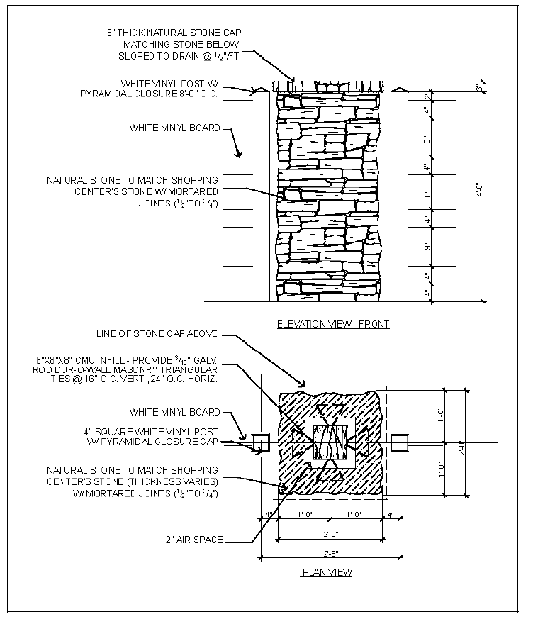
(9)
Equestrian-style fencing composed of vinyl and stone masonry columns shall be installed along Castleberry Road and Bethelview Road. Fence design shall conform to construction detail shown below. Stone masonry columns shall be placed 50 feet on center.
(b)
Pedestrian and bicycle circulation. Pedestrian connections and walkways shall be provided throughout commercial and mixed use developments.
(1)
Commercial buildings shall provide organized circulation for pedestrians with a clear walkway, no less than five feet in width, from the public sidewalk or right-of-way to main entrances of all principal buildings on the site. At a minimum, walkways shall connect focal points of pedestrian activity such as, but not limited to, street crossings, transit stops, building and store entry points.
(2)
All internal pedestrian walkways shall be distinguished from driving surfaces through the use of color and durable, low maintenance surface materials such as pavers, bricks, or scored concrete to enhance pedestrian safety and comfort, as well as the attractiveness of the walkways.
(3)
Sidewalks, no less than five feet in width, shall be provided along the full length of the building along any façade featuring a customer entrance, and along any façade abutting public parking areas. Such sidewalks shall be located at least six feet from the façade of the building to allow for landscaping.
(4)
Commercial establishments shall design drive-throughs to minimize vehicular/pedestrian conflicts.
(5)
Commercial establishments shall provide bike racks, benches and/or other street furniture to encourage alternative transportation use.
(Added 1-4-2007; Amd. of 12-1-2011; Amd. of 1-5-2023)
21-7.6. - Architectural design standards.
The architectural design standards established herein apply to all development requiring a land disturbance permit. They are intended to achieve a base level of quality for architectural and landscape design that is responsive to its context and contributes to the overall character of the overlay district. The architectural criteria listed below establish minimum design standards within the overlay district in order to reduce the impacts of development on adjacent properties. The highest quality of architectural design and innovation is encouraged. These standards are in addition to the design criteria contained in chapters 11 and 12:
(a)
Building materials and architectural treatments. The following design standards, guidelines, and enhancements are established to create a sense of architectural consistency throughout the overlay district, ensure high quality architectural design, and maintain a sense of rural character.
(1)
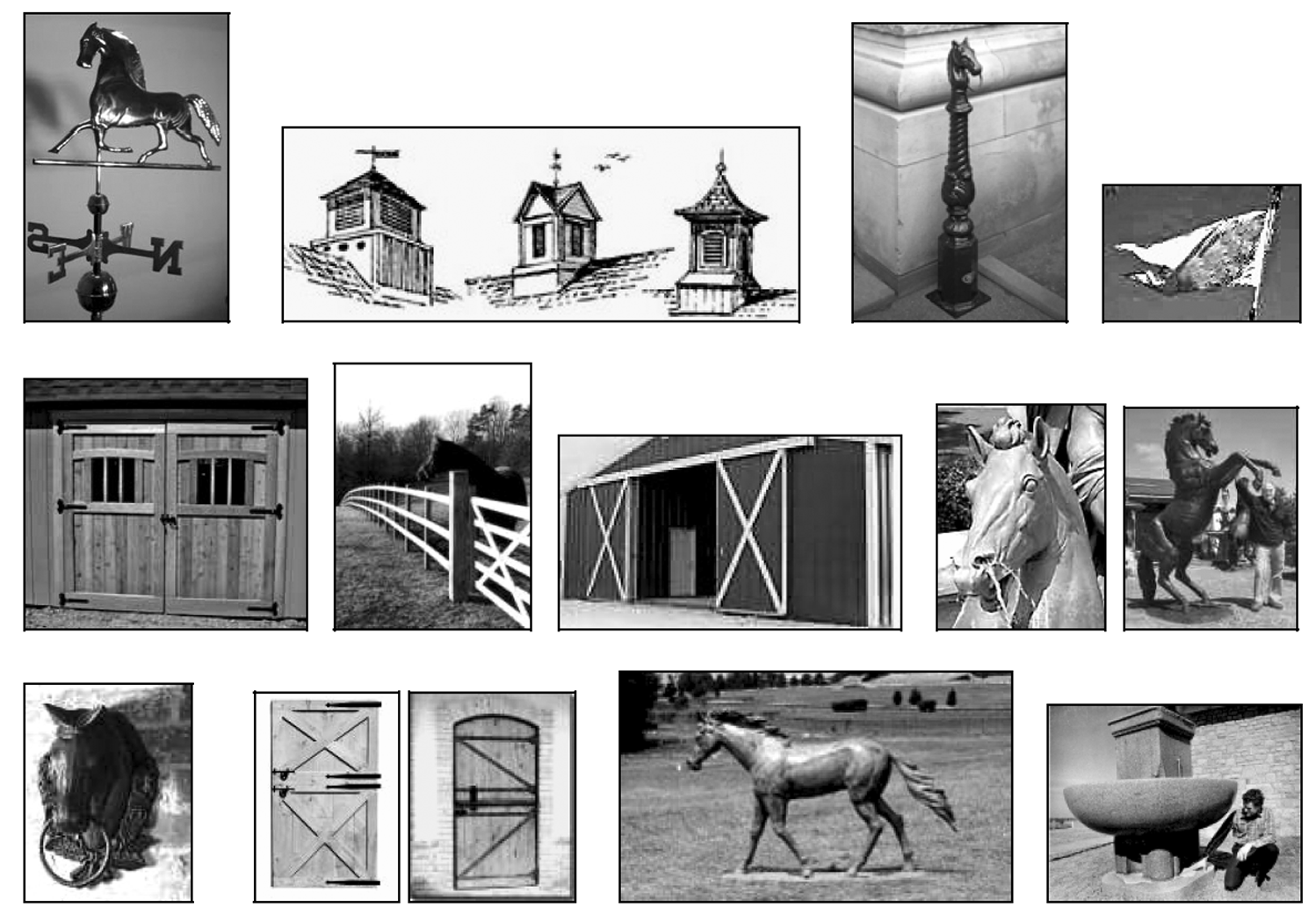
Commercial development shall adhere to an equestrian design theme through the incorporation of at least two of the following design elements: roofline features (gable vents, cupolas, weathervanes, metal pennant flags), façade details (faux or functional barn motif window and door treatments, equestrian designed wall mounts), and landscape (equestrian bollards, water feature, outdoor art installation in addition to required equestrian fencing). Design possibilities include, but are not limited to, those indicated in the photographs below and those listed in Table 21.1.
TABLE 21.1
EXAMPLES OF EQUESTRIAN ARCHITECTURAL AND LANDSCAPE ELEMENTS
(2)
Commercial development shall incorporate design elements of the surrounding architecture, including roof forms, window fenestration patterns, finishes, and materials and colors, thereby maintaining the common equestrian design theme. See Table 21.2 for an approved exterior finish schedule. Alternative schedules require the submission of a materials sample panel which must be approved by planning and community development staff.
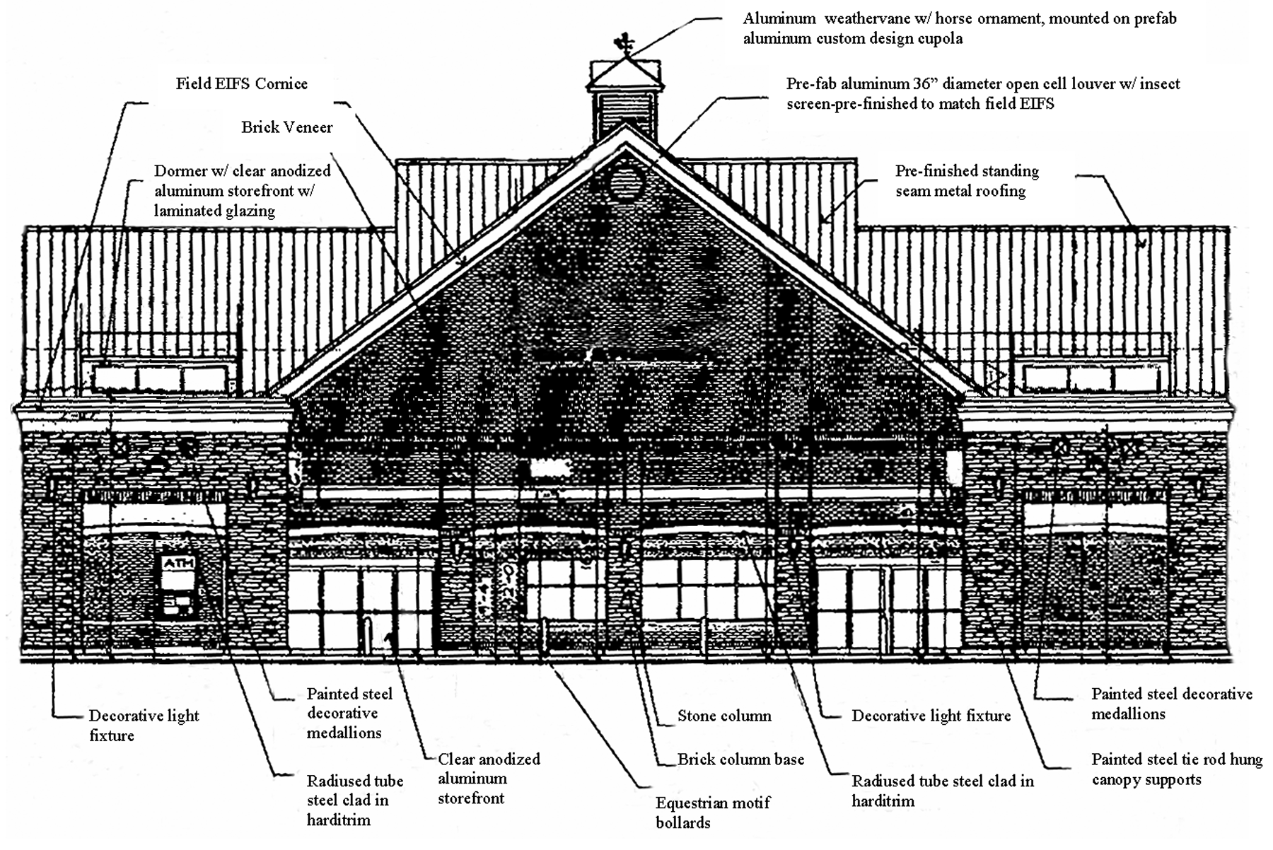
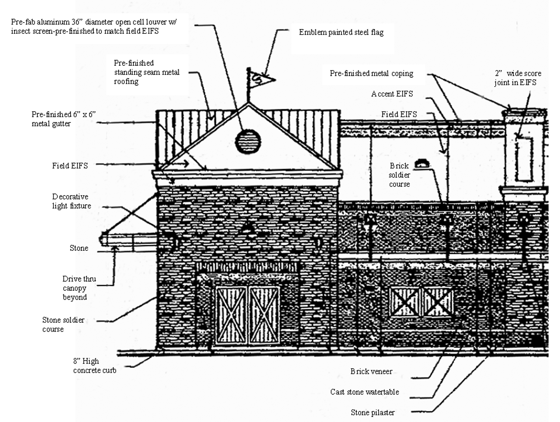
TABLE 21.2
PRE-APPROVED COMMERCIAL EXTERIOR FINISH SCHEDULE
(3)
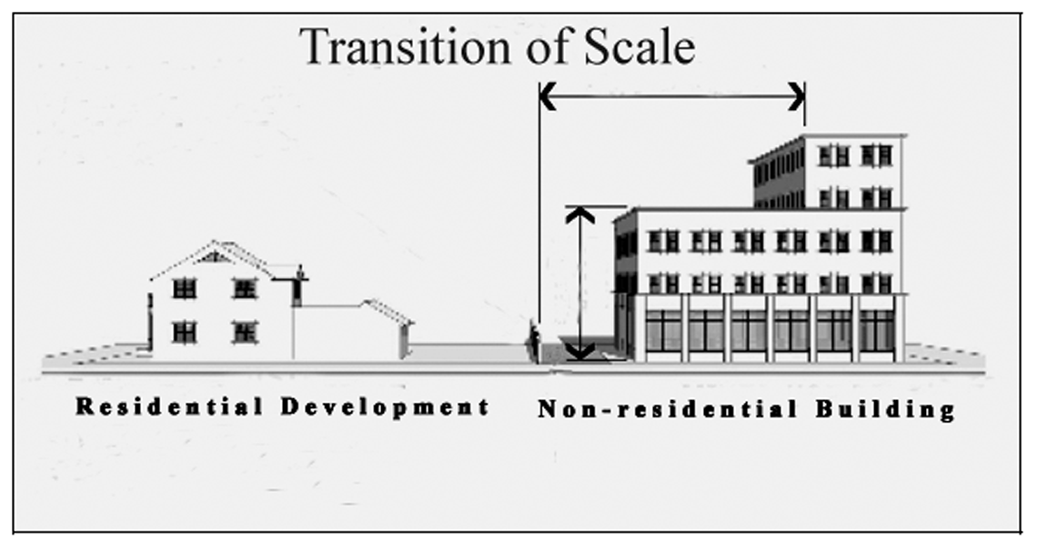
Any new proposed commercial buildings shall achieve an orderly transition in scale to existing buildings on adjacent properties and in the immediate area. Building heights for nonresidential developments, when adjacent to a residential use or along a street, shall have an appropriate transition or step-down of building scale to reduce and mitigate any potential adverse impacts.
(4)
Commercial buildings shall be composed of brick, stone and glass with a maximum of 15 percent of accent material which may include stucco, exterior insulating finish system (EIFS), painted dimensioned wood or cement based material, such as Hardiplank. Exterior building material, except rear façades that do not face a public right-of-way, shall not be of pre-cast concrete, concrete masonry units, aluminum or vinyl siding, job site tilt up panels, or corrugated steel. An exterior finish schedule identifying building materials used for all building faces shall be submitted for approval with building elevations prior to design review. In addition, elevations should clearly show the location and calculate the amount/percentages of all building materials per façade.
(5)
Front façades of commercial buildings shall include pedestrian-scaled architectural elements or details at the first floor level. Examples include, but are not limited to, the following:
a.
First story delineation through change of materials, colors, or fenestration; blank wall areas cannot exceed five vertical feet without delineation.
b.
Canopies/awnings/trellises.
c.
Outdoor dining areas for restaurant establishments.
d.
Outdoor benches/seating area(s) for commercial retail.
e.
Soldier coursing or stonework integrated into the building face.
(6)
Commercial buildings shall include articulation of the primary entry area which shall feature no fewer than two of the following elements:
a.
Overhangs.
b.
Canopies.
c.
Recesses/projections.
d.
Arcades.
e.
Corniced parapets over the door.
f.
Peaked roof forms.
g.
Arches.
h.
Display windows.
i.
Integral planters or wing walls that incorporate landscaped areas and/or places for sitting.
(7)
Exterior façades of a free standing building located on an outparcel of a larger commercial development and/or accessory commercial structures shall be considered primary façades and shall employ architectural, site, and landscaping design elements which are integrated with and common to those used on the primary structure on the site. However, such guidelines do not apply to any façade(s) facing service courts or other areas generally not visible to the public. Common design elements shall include colors, architectural details and materials associated with the main structure or structures on the larger development.
(8)
Roof features. Rooflines on commercial buildings shall incorporate roof features (extensions, and/or projections such as gable, hip, parapet, dormers or others) that achieve visual interest through variation along one third of the entire horizontal length of roofline. These features shall conform to the following specifications where applicable:
a.
Roof features shall not exceed the average height of the supporting walls.
b.
The average height of parapets shall not exceed 15% of the height of the supporting wall and shall not at any point exceed one-third of the height of the supporting wall. Parapets shall feature three dimensional cornice treatments.
c.
The roof pitch of sloped roofs shall be a minimum of 4:12.
d.
Roof styles for multi-building complexes shall be compatible and consistent with roof designs for the entire complex.
e.
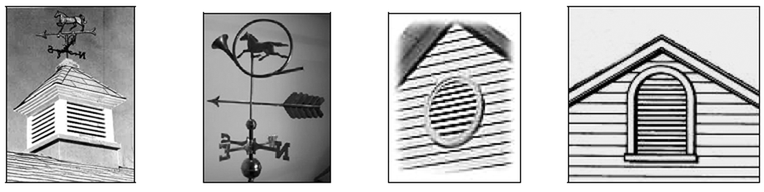
Appropriately sized and designed gable vents, cupolas and/or weathervanes in keeping with an equestrian motif, shall be incorporated into the roofline. Illustrative examples are shown in the following photographs:
(9)
Material and/or color changes on commercial buildings generally shall occur at a change of plane. Piecemeal embellishment and frequent changes in material shall be avoided.
(10)
New residential development shall use a variety of techniques to avoid the monotonous appearance of identical homes. Such techniques may employ among others, the use of differing front elevations, architectural styles, building exteriors or other techniques to provide a more pleasing appearance to the subdivision. No vinyl or aluminum siding shall be allowed.
(11)
New residential development shall respect the scale and character of adjacent residential neighborhoods through attention to views, building scale and orientation, proximity to adjacent uses, location of driveways, noise, lighting and landscape.
(b)
Exterior lighting. All lighting shall be designed to integrate with the overall development character. A lighting plan is required to be submitted at the time of application for a building permit that addresses and conforms to all provisions set forth in this section. The lighting plan shall address fixture design and location. In addition to section 16-4.25, the following shall apply:
(1)
Lighting shall be architecturally integrated with the style, material, and color of on-site structures.
(2)
Mounting heights and shielding shall be utilized to effectively control glare and light trespass. Light fixtures over 14 feet in height shall be full cutoff fixtures. Pedestrian light fixtures 14 feet in height or less may be cutoff or semi-cutoff fixtures. See section 16-4.25 for light spillage and height regulations.
(3)
Lighting shall not blink, flash, or oscillate.
(4)
All outside illumination of any building and/or surrounding landscape, except for security purposes, is prohibited after 11:00 p.m. or when the business closes, whichever is later.
(5)
All lighting fixtures on a project site shall be from the same family of fixtures with respect to design, materials, finish, color, and color of light and shall complement the architectural theme and materials established by the primary buildings. Compatibility of fixture styles shall be approved by planning and community development staff.
(6)
Architectural lighting of building façades: Building illumination and architectural lighting shall be indirect in character and shall respect and reinforce the architectural treatment of the building.
a.
Upward aimed building façade lighting shall not exceed 900 lumens and shall not require shields. All upward aimed lights shall be fully confined from projecting into the sky by eaves, roofs, or overhangs.
b.
Building façade lighting exceeding 900 lumens shall be shielded, aimed downward, and shall be mounted as flush to a wall as possible.
c.
All lighting shall be fully contained within the vertical surface of the wall being illuminated.
d.
Highly polished surfaces such as glass, marble, glazed tile, glazed brick, porcelain enamel, and highly reflective metals shall not be lighted directly to minimize reflective glare.
(7)
Swivel-mounted luminaries and wall packs are prohibited.
(8)
Landscape lighting shall only be utilized to accent landscaping, be pointed away from the property line, and fixtures shall contain extension shields to minimize glare and light source visibility.
(c)
Screening. In addition to regulations set forth in chapter 12, the following standards shall apply to commercial development:
(1)
All ground mounted mechanical, HVAC, electric and communications transformers and like systems shall be screened from view from any public right-of-way and any residential use by one of the following: placement behind the building, 100 percent opaque fencing, an earthen berm, and/or a vegetative screen planted according to county buffer standards.
(2)
Flat roofs, roof mounted equipment and other accessories shall be screened from public view by a parapet, gable roof, roof screen, or architectural feature. Roof equipment and roof screens shall be finished to match the roof or parapet wall.
(3)
Loading areas shall be screened from the public right-of-way and any residential use by placement behind the main building, an earthen berm and/or vegetative screen planted according to county buffer standards.
(4)
Drive-throughs and stacking lanes, when contiguous to any public right-of-way, residential use, or pedestrian gathering area shall be obscured from view by placement behind the building, an earthen berm and/or vegetative screen planted according to county buffer standards.
(5)
All parking areas shall be screened from view with evergreen shrubs. Shrub height shall be no less than three feet as measured from the top of curb of the parking areas.
(6)
Outside storage is prohibited, except for seasonal sales of holiday trees, nursery supplies, and pumpkins. In no instance shall outdoor display obstruct sidewalks or otherwise impede pedestrian movement to the establishment's entrance.
(7)
Storage of shopping carts shall be indoors and/or located adjacent to the building where the carts are utilized. Storage/enclosure shall be made out of masonry to match the exterior building materials. Parking lot corrals are allowed.
(8)
Chain link or coated chain link fence is prohibited along road frontage for Castleberry Road and Bethelview Road. If fences are not located along road frontage, but are visible from the right-of-way, fences must be screened by vegetation for their full length and height.
(d)
Color. Color shades shall be used to unify and integrate the overall development project.
(1)
Vending and ice machines, lock boxes and other dispensing equipment visible from the public right-of-way shall use only earth tone and/or neutral colors. Fuel dispensing units visible from the public right-of-way shall feature earth tone and/or neutral colors in their overall design. Notwithstanding the foregoing requirement, small functional parts of the fuel dispensing units and reasonable safety features may utilize additional colors for enhanced visibility and safety purposes, subject to the discretion of the director. In addition, any wall or fence shall use only earth tone and/or neutral colors. Earth tone colors refer to browns, umbers, sienna, or terracotta and brick tones. Neutral colors refer to blacks, whites, beiges, or grays.
(2)
See Table 21.2 for a pre-approved color patette for commercial buildings. Building trim may feature accent colors satisfying the intent of this subsection, subject to approval by staff. If natural brick is used, it shall not be painted.
(Added 1-4-2007; Amd. of 12-1-2011; Amd. of 2-2-2017(9); Amd. of 4-15-2021; Amd. of 10-7-2021; Amd. of 1-5-2023; Amd. of 11-2-2023; Amd. of 3-6-2025)
21-7.7. - Signage.
This section establishes minimum standards to promote and ensure a cohesive and unified identification program within the overlay district. A detailed signage plan is required to be submitted that addresses and conforms to all provisions set forth in this section. The signage plan shall address sign dimensions, color scheme, lighting, location of each sign on the building and on the ground, materials, and height. In addition to Ordinance No. 74 (Sign Ordinance), the following shall apply:
(a)
All sign designs shall conform to established color guidelines and complement the architecture of the building and site plan in terms of size, shape, color, texture, and lighting.
(b)
The architectural color standards of the district apply only to the sign structure not to the sign face.
(c)
The size and shape of a sign shall be proportionate with the scale of the structure.
(d)
Wall signs shall be flush against the wall, not cover architectural features or details, and not extend beyond the roof line or outer edges of the building.
(e)
Where there is more than one sign on a site, signs shall be complementary to each other in shape and have related components and type of construction materials.
(f)
Monument signs shall match the principal building material(s).
(g)
Any exterior light source shall be completely shielded and directed solely on the sign and not upon any other object or adjacent properties.
(h)
Signage shall not have illuminating devices that have a changing light intensity, brightness, or color.
(i)
Electronic message boards (EMBs) are prohibited.
(Added 1-4-2007; Amd. of 1-5-2023)
21-7.8. - Miscellaneous provisions.
(a)
No commercial use shall be designated or operated so as to expose residents to offensive odors, dust, electrical interference, and/or vibration.
(b)
Outdoor seating areas, play equipment, and perimeter fencing shall be of compatible and attractive design that is integrated with the main building architecture.
(c)
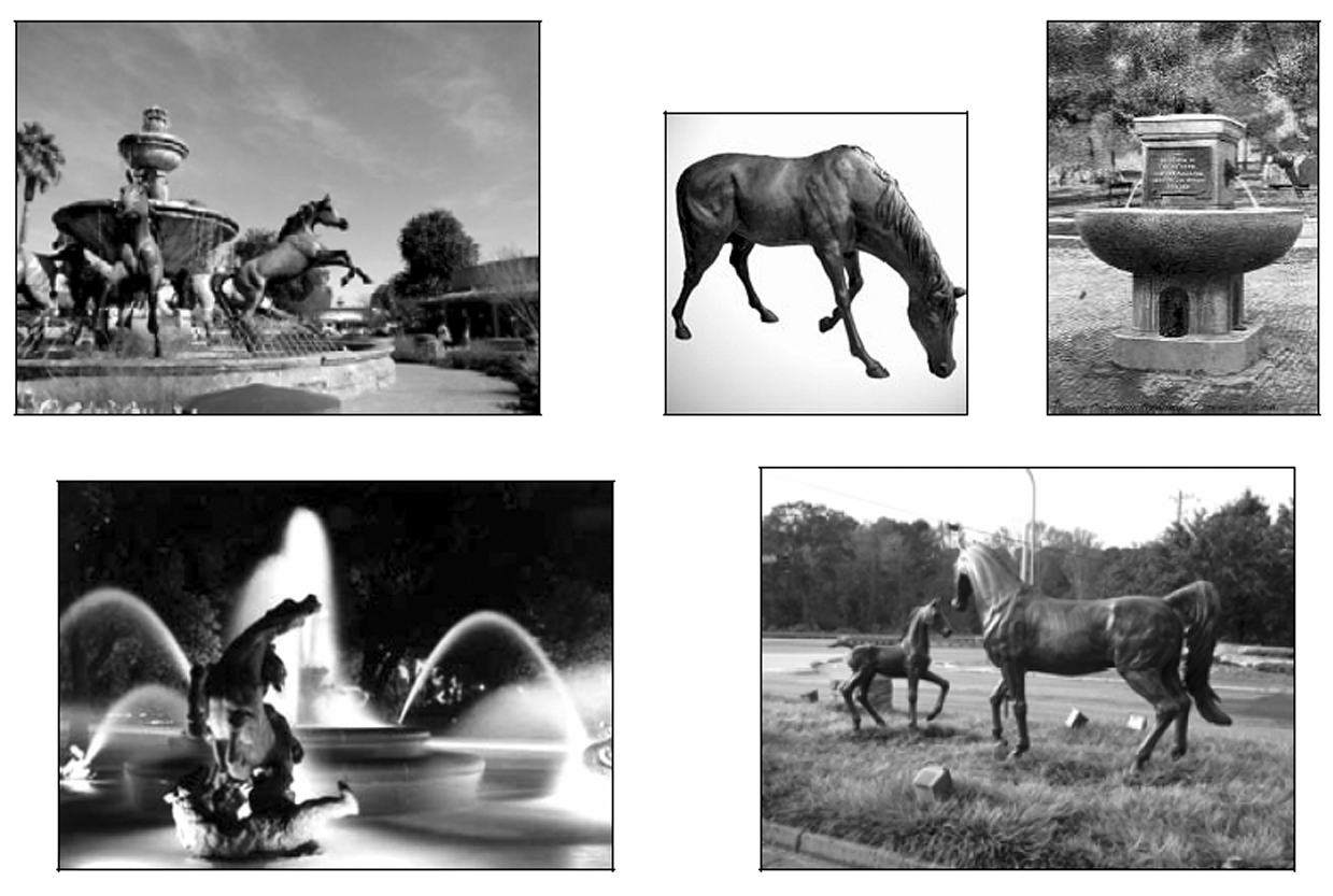
Amenities such as kiosks, water fountains, and public telephones are encouraged. Outdoor art installations may also be provided in the open spaces, plazas, and along streetscapes to provide visual interest and diversity. The following are illustrative examples of equestrian art and fountain installations that could be adapted for the overlay district:
(Added 1-4-2007)
21-8.1. - Purpose.
The purpose of this overlay district is to establish minimum standards for non-residential site development, exterior architectural design, landscaping, lighting and signage that contribute to the district's overall character. This is accomplished through enhancement of commercial growth through unity of design and quality architecture and the creation of visual interest through landscape and architectural features. Design standards are intended to ensure coordinated design of building exteriors in order to promote visual congruence, positively impact adjacent properties, and produce buildings that augment the character and appearance of the area. It is the goal of this ordinance to promote freedom in design while establishing a baseline for design compatibility. This goal is in accordance with the county's objective to encourage landscaping, signage, building design, and other development regulations that enhance the image of the county and create value as stated in the implementation program of the Comprehensive Plan. In addition, the overlay district complies with the respective subarea visions which state that the vicinity will be the site of quality development and business opportunities. The subarea visions also maintain that the area will be known to have grown in a responsible manner, offering residents a high quality of life as well as opportunities for employment, shopping, and recreation.
(Added 2-1-2007; Amd. of 5-3-2012)
21-8.2. - Delineation of district.
The Peachtree Parkway/Bethelview Road Overlay District applies to all properties indicated on the Official Overlay District Map of Forsyth County. Regulations pertain to parcels or portions of parcels that fall within 1,000 feet of the centerline of Peachtree Parkway/Highway 141/Bethelview Road (from Highway 141) to the intersection with Kelly Mill Road with the exception of parcels within the Castleberry-Bethelview Crossroads Overlay District. If a portion of a parcel extends beyond the boundary of the overlay district, overlay regulations may extend to the remaining portion of the parcel(s) at the option of the property owner. Where land is classified as an overlay district, the regulations governing development in the overlay district shall apply in addition to the regulations governing development in the underlying base zoning district. In the event of an express conflict between the standards governing a base zoning district and those governing an overlay district, the standards governing the overlay district shall control.
(Added 2-1-2007; Amd. of 5-3-2012)
21-8.3. - Permitted uses.
All uses allowed in the underlying zoning districts as established by this Code, except for those listed below, are permitted in the Peachtree Parkway/Bethelview Road Overlay District. Commercial zoning districts and uses are strongly encouraged south of Highway 9 based on the designation of Peachtree Parkway as a commercial corridor within the Forsyth County Comprehensive Plan. The designation of this portion of the highway corridor as a commercially focused area shall be considered as rezoning proposals are submitted for properties located within the overlay district boundary.
(a)
Senior housing developments; and
(b)
Tattoo parlors.
(Added 2-1-2007; Amd. of 5-3-2012; Amd. of 12-2-2021; Amd. of 5-5-2022)
21-8.4. - Design plan administrative review.
Design review shall be performed by county planning and community development staff. All plans shall address and conform to all provisions set forth under chapter 21, article VIII. Any numerical nonconformance to the standards contained within this article shall equire the submittal of a variance application in accordance with section 8-6.4 of this Code. Should a design not meet all of the non-numerical standards contained within this article, then the proposed design must be submitted for public hearing to the Forsyth County Board of Commission for review and approval as an alternate design review. In considering whether to approve such alternate design, the board of commissioners shall consider the special considerations set forth in section 8-5.5(F)(2)(b) of this Code. Architectural elevations, exterior finish schedules, landscape, and signage plans must be submitted to the planning and community development department at the time of application for a land disturbance permit. Lighting plans must be submitted prior to the issuance of a building permit. See chapter 7 and chapter 18 for land disturbance and building permit procedures.
(Added 2-1-2007; Amd. of 6-16-2011; Amd. of 12-1-2011; Amd. of 4-5-2018)
21-8.5. - Site design standards.
(a)
Parking for commercial establishments shall be distributed along not less than two sides of the building exterior. Parking that fronts the main building entrance(s) shall not exceed sixty (60) percent of parking total or 300 parking spaces, whichever is less.
(b)
New commercial developments and substantial improvements to existing commercial developments shall provide for pedestrian and automobile access connections between adjacent commercial properties.
(c)
Speed bumps are prohibited within commercial developments. Speed tables are permitted.
(d)
Landscaping. The intent of this section is to require the integration of all landscape improvements with the overall project site requirements. All plant materials shall be used to enhance the existing area, particularly as viewed from an adjacent right-of-way, and to mitigate development impacts. Landscape plans shall be submitted to the planning and community development department for design review. The following is in addition to Ordinance No. 98 (Tree Protection and Replacement Ordinance) and shall be implemented:
(1)
Plant materials shall be used as accent elements at roadside entryways to provide a definite sense of arrival to commercial properties. Plant materials shall consist of ground cover, herbaceous ornamentals, shrubs, understory, and/or overstory trees adjacent to the establishment's monument sign(s). These materials shall be clustered while maintaining adequate sight distance to and from the entryway. Entryway plantings shall be compatible with adjacent landscape areas in species selection and provide a cohesive transition between landscape plantings.
(2)
All landscape areas shall provide a design of appropriate character and shall incorporate a minimum of 40 percent evergreen trees and shrubs. All landscape areas shall also incorporate a minimum of 25 percent native plant material. Such plant material must be indigenous to the Southeastern U.S. and be approved by the county arborist.
(3)
A minimum 25-foot wide landscape strip shall be provided along the proposed future rights-of-way and reservation lines of Georgia Highway 141/Peachtree Parkway/Bethelview Road.
(4)
All landscape strips are required to contain a combination of at least two of the following elements to provide a minimum of three levels of scale: vegetative ground cover, herbaceous ornamentals, and low to mid-level shrubs in addition to a combination of large canopy trees. All proposed shrubs should be a minimum of three-gallon size and two feet high at time of planting spaced every five feet on center. Strips must also include large canopy trees with total caliper measurements equivalent to a minimum of six caliper inches per 50 linear feet with a minimum two-inch caliper and eight-foot height required at time of installation for each tree. Tree placement may be grouped and staggered rather than following a regulated line along the road frontage. Trees shall count towards the tree density requirements as outlined in Ordinance No. 98 (Tree Protection and Replacement Ordinance).
(5)
A minimum of ten feet of the required 25-foot landscape strip shall be located behind utility easements so plant material will not be disturbed after installment.
(6)
All parking areas shall be screened from view with evergreen shrubs. Shrubs shall be no less than three feet in height as measured from the top of curb of the parking areas. Exemption to this requirement may be requested when the site is significantly below road grade level.
(7)
Landscape installment and maintenance. Certification by a registered landscape architect verifying that landscaping meets the standards of this Code and the approved plans must be submitted. In addition, the contractor responsible for landscape installation must certify that all plant material has been installed per the approved plans. These certifications must be submitted prior to the approval of the as-built and/or final plat.
(8)
All dead and damaged plant material within landscaped areas must be replaced with a similar species within one month. If weather conditions are not appropriate for replanting, the property owner may postpone replacement for up to six months. Replacement trees and shrubs shall be of similar size to trees or shrubs being replaced.
(9)
Performance security. When planting stock availability is low or weather conditions are not appropriate for planting new trees, shrubs, and/or perennials, the property owner may postpone planting for up to six months, provided that performance security is posted with Forsyth County in accordance with the following criteria:
a.
Security shall be in an approved form submitted to the department of planning and community development with appropriate documentation of stock availability and weather conditions.
b.
Security shall be in an amount equal to 110 percent of the cost of materials, installation, and guarantee, as demonstrated by a signed contract between the owner and a landscape contractor and approval by department of planning and community development.
An inspection shall be made by the department of planning and community development of all plantings to assure compliance with plan requirements prior to release of performance security. Forsyth County will use the performance security at the time of expiration if the planting requirements have not been fulfilled, or if the owner has not requested an extension. Funds received from the performance security will be used to bring the project into compliance. One six-month extension is permitted with documented justification. Any inspections performed after the final inspection for project release are subject to re-inspection fee schedules, which shall be maintained on file at the department of planning and community development.
(10)
Retaining walls, if necessary, must be faced with brick, stone, cast stone or split face modular block if visible from the right-of-way.
(Added 2-1-2007; Amd. of 12-1-2011; Amd. of 5-3-2012)
21-8.6. - Architectural design standards.
The architectural design standards established herein apply to all commercial development requiring a land disturbance permit. They are intended to achieve a base level of quality for architectural and landscape design that is responsive to its context and contributes to the overall character of the overlay district. The architectural criteria listed below establish minimum design standards within the overlay district in order to reduce the impacts of commercial development on adjacent properties. The highest quality of architectural design and innovation is encouraged. These standards are in addition to the design criteria contained in chapters 11 and 12.
(a)
Building materials and architectural treatments. The following design standards, guidelines, and enhancements are established to create a sense of architectural consistency throughout the overlay district and to ensure high quality architectural design.
(1)
Exterior building materials on all commercial development shall consist of a minimum of 75 percent per vertical wall plane of brick, natural or pre-cast stone, and/or glass. If multiple establishments are contained within one contiguous structure, the percentage pertains to the entire façade rather than individual façade fronts.
(2)
Accent wall materials on all commercial development shall not exceed 25 percent per vertical wall plane. Accent building materials include, but are not limited to, exterior finish insulation systems, stucco, and painted dimension wood. If multiple establishments are contained within one contiguous structure, the percentage pertains to the entire façade rather than individual façade fronts. Smooth, split face and/or rib faced concrete masonry units, aluminum siding, vinyl siding, and corrugated steel are prohibited.
(3)
The principal entry area of a building, or if in a shopping center the largest tenant or a central location of a group of buildings, shall be articulated and should express greater architectural detail than other portions of the building. Entries shall include at least one of the following or similar architectural elements:
a.
Overhangs.
b.
Canopies.
c.
Recesses/projections.
d.
Columns.
e.
Arcades.
f.
Corniced parapets over the door.
g.
Peaked roof forms.
h.
Arches.
i.
Display windows.
j.
Integral planters or wing walls that incorporate landscaped areas and/or places for sitting.
(4)
Freestanding accessory structures shall have architectural detailing and design elements consistent with the primary buildings of the development complex to provide a cohesive design.
(5)
Roof features. Rooflines on commercial buildings shall incorporate roof features (extensions, and/or projections such as gable, hip, parapet, dormers or others) that achieve visual interest through variation along one third of the entire horizontal length of roofline. These features shall conform to the following specifications where applicable:
a.
The roof pitch of sloped roofs shall be a minimum of 4:12.
b.
Roof styles for multi-building complexes shall be compatible and consistent with roof designs for the entire complex.
(6)
Burglar bars, fiberglass awnings, and steel-roll down curtains are prohibited except at the structure's rear. Burglar bars are prohibited on the rear if visible from a public street. Burglar bars are also prohibited on the rear of an outparcel building if visible from the main structure.
(b)
Color. The use of muted, subdued, or earth tone colors are required for all buildings and associated structures. Vending and ice machines, lock boxes and other dispensing equipment visible from the public right-of-way shall use only earth tone and/or neutral colors. Fuel dispensing units visible from the public right-of-way shall feature earth tone and/or neutral colors in their overall design. Notwithstanding the foregoing requirement, small functional parts of the fuel dispensing units and reasonable safety features may utilize additional colors for enhanced visibility and safety purposes, subject to the discretion of the director. In addition, any wall or fence shall use only earth tone and/or neutral colors. Earth tone colors refer to browns, umbers, sienna, or terracotta and brick tones. Neutral colors refer to blacks, whites, beiges, or grays. Fluorescent colors and those bright in intensity are prohibited. Glass, unpainted metal, natural stones, and sign faces are excluded from the color requirements.
(c)
Exterior lighting. All lighting for commercial development shall be designed to integrate with the overall development character.
(1)
Lighting shall be architecturally integrated with the style, material, and color of on-site structures.
(2)
Lighting shall be unobtrusive and refrain from adverse impact of adjacent properties and public rights-of-way. See section 16-4.25 for fixture type, light spillage, and height regulations.
(3)
Exposed neon and fluorescent lighting is not permitted except for open and closed signs.
(4)
For drive-under canopies and fuel dispensing units, the luminaries shall be recessed into the canopy ceiling so that the bottom of the luminaries does not extend below the ceiling.
(5)
Promotional beacons, search lights, laser source lights, strobe lights or any similar light when projected above the horizon, and lighting used for causing sky glow to attract attention in excess of the lighting used to provide safety, security and utility are prohibited. Projects that want to integrate lines or rows of lights within a defined pedestrian plaza may seek administrative approval upon submission of lighting specifications. Such lights shall not be placed permanently on building exteriors.
(6)
Pedestrian street lights, not to exceed 14 feet in height, shall be installed along SR 141/Peachtree Parkway from Majors Road to SR 9/Atlanta Highway per GDOT approved lighting plan.
(7)
Chain link fencing is prohibited on SR 141/Peachtree Parkway/Bethelview Road frontage. Chain link fencing may be allowed along the sides and rear of property fronting SR 141/Peachtree Parkway/Bethelview Road if it is screened with evergreen trees, shrubs, and/or decorative fencing for the full length and height of the fence.
(d)
Screening. In addition to regulations set forth in chapter 12, the following standards shall apply:
(1)
Accessory site features including, but not limited to, meters, meter boxes, electrical transformers, and other equipment located on the ground shall be screened from view from public rights-of-way, residential uses, or any residential or agricultural zoning category by placement behind the main building, 100 percent opaque fencing, berm and/or a vegetative screen planted according to county buffer standards.
(2)
Flat roofs, roof mounted equipment and other accessories shall be screened from view from the public rights-of-way, residential uses or any residential or agricultural zoning category by a parapet, gable roof, roof screen, or other architectural feature. Roof equipment and roof screens shall be finished to match the roof or parapet wall. When the relationship between building roofs and adjoining public streets and/or residential developments make screening of roof equipment impossible (e.g. road higher than roof), a parapet of no less than four feet in height shall be installed.
(3)
Loading areas shall be screened from the public rights-of-way, residential uses, or any residential or agricultural zoning category by placement behind the main building or appropriately scaled wall, the use of earthen berms that are no less than five feet in height and/or a vegetative screen planted according to county buffer standards.
(4)
Drive-thru facilities and stacking lanes, when contiguous to any public right-of-way, residential use, or pedestrian gathering area shall be obscured from view by an earthen berm and/or a vegetative screen planted according to county buffer standards.
(5)
Reserved.
(6)
Storage of shopping carts shall be located adjacent to the building where the carts are utilized. Storage/enclosure shall be made out of masonry to match the exterior building materials. Parking lot corrals are allowed.
(7)
Walls or fences, required or otherwise, when visible from the right-of-way shall complement the exterior materials of the primary structure on site. Tarps and banner signs shall not be attached to fencing material.
(8)
Chain link fencing is prohibited on SR 141/Peachtree Parkway frontage. Chain link fencing may be allowed along the sides and rear of property fronting SR 141/Peachtree Parkway if it is screened with evergreen trees, shrubs, and/or decorative fencing for the full length and height of the fence.
(Added 2-1-2007; Amd. of 5-3-2012; Amd. of 12-20-2016; Amd. of 4-15-2021; Amd. of 10-7-2021; Amd. of 11-2-2023; Amd. of 3-6-2025)
21-8.7. - Signage.
This section establishes minimum standards to promote and ensure a cohesive and unified identification program within the overlay district. A detailed signage plan is required to be submitted that addresses and conforms to all provisions set forth in this section. The signage plan shall address sign dimensions, materials, height, color scheme, lighting, and location of each sign on the building and on the ground. In addition to Ordinance 74 (Sign Ordinance), the following shall apply:
(a)
Freestanding sign structure/base materials shall match the principal building material.
(b)
Wall signs shall not cover architectural features or details, and not extend beyond the roof line or outer edges of the building.
(c)
Where there is more than one sign on a site, signs shall be complementary to each other in shape and related components and type of construction materials.
(d)
Any exterior light source shall be completely shielded and directed solely on the sign and not upon any other object or adjacent properties.
(e)
Wall mounted raceways shall be painted to match the adjoining wall surface.
(Added 2-1-2007)
21-9.1. - Purpose.
The purpose and intent of the Forsyth County Board of Commissioners (the "commission") in establishing this overlay district is as follows:
(a)
To support flexibility and innovation for regional mixed-use developments encompassing more than 150 acres of land through the complementary integration of office, retail, restaurants, commercial, entertainment, hotel, residential and recreational land uses;
(b)
To encourage pedestrian circulation, integrate open space, and create a regional retail and mixed-use development;
(c)
To enhance the long term economic viability of the southern portion of Forsyth County by encouraging regional retail and mixed-use development that increases the tax base and generates a substantial employment base;
(d)
To foster a more balanced relationship between commercial and residential growth to ensure a stable and healthy tax base in Forsyth County; and
(e)
To encourage an efficient and sustainable community development plan.
(Amd. of 4-3-2008; Amd. of 1-9-2025)
21-9.2. - Boundaries and description of area.
The boundaries of the approximate 164-acre Ronald Reagan/Union Hill Overlay District (the "overlay") shall be as shown on the Official Overlay District Map of Forsyth County, as established and adopted pursuant to section 9-1.4 of the Forsyth County Unified Development Code (the "UDC"). All property within Subarea 1 of the overlay shall be developed in phases as set forth in the Memorandum of Understanding between Forsyth County, Georgia and The Gathering at South Forsyth, LLC Related to the Proposed Gathering Arena/Mixed-Use Project dated March 26, 2024. In addition, the County and the developer shall enter into a development agreement (the "development agreement") providing more detail or modifications to the terms of the Memorandum of Understanding. The development agreement must be reviewed and approved by the board of commissioners prior to issuance of a land disturbance permit for any area within Subarea 1 of the overlay. In the event of any conflict between the memorandum of understanding and the development agreement, the provisions of the development agreement shall govern.
Further, all property within the overlay shall adhere to sub-area regulations and all other standards in accordance with this article and generally in accordance with the Master Development Plan (the "plan") for the overlay. The plan is intended to provide a conceptual context in which property within the overlay may be developed in accordance with this article. The reassignment of land uses for buildings depicted on the plan shall not require a formal plan amendment unless such land use reassignment constitutes a major plan amendment, as set forth in section 21-9.10 of this article. Approval of a sketch plat, as set forth in chapter 8, article V of the UDC, or any other similar site plan approval shall not be required for new development within the overlay.
(Amd. of 4-3-2008; Amd. of 1-9-2025)
21-9.3. - Relationship to underlying zoning and other regulations.
The provisions of this article are supplemental to the zoning district in which the property is located. All properties within the boundaries of the overlay shall meet the development requirements of the underlying CBD zoning district, or other zoning district if the CBD zoning district is changed for the property, or zoning conditions specific to the property or as such may be amended, and in addition shall meet all of the provisions of this article. The provisions of this article shall be the only overlay provisions applicable within the boundaries of the overlay. In the event of a conflict or inconsistency between the provisions of this article and any other provision of the UDC, the Forsyth County Tree Protection and Replacement Ordinance (the "tree ordinance"), the Forsyth County Sign Ordinance (the "sign ordinance"), the Forsyth County Noise Ordinance (the "noise ordinance"), or the GA400 Buffer (UDC Section 10-1.10), this article shall govern the development of the property within the boundaries of the overlay. In addition, the provisions of the South Forsyth Commercial Design Standards (UDC chapter 12, article XIII) and the provisions of the Southeast Forsyth Design Standards (UDC section 11-9.7) shall not apply to properties within the overlay.
(Amd. of 4-3-2008; Amd. of 1-9-2025)
21-9.4. - Sub-area 1 (regional mixed-use).
This sub-area is intended to provide a high density, regionally- marketed retail and mixed-use development as identified on the plan.
(a)
Permitted uses.
(1)
Commercial recreation facility, outdoor.
(2)
Commercial recreation facility, indoor.
(3)
Multi-purpose arena (the "arena") having capacity as specified in the development agreement.
(4)
Gathering entertainment district.
(5)
All uses permitted under CBD (commercial business district) zoning, subject to section 21-9.8(n) of this article.
(6)
All conditional uses permitted under CBD (commercial business district) zoning, subject to section 21-9.8(n) of this article.
(7)
Multi-family dwelling units which shall not exceed 1,800 to be developed in phases as set forth in the memorandum of understanding between Forsyth County, Georgia and The Gathering at South Forsyth, LLC Related to the Proposed Gathering Arena/Mixed-Use Project dated March 26, 2024. Multi-family dwelling units are also subject to the following:
(a)
The minimum heated floor space for studio units shall be 450 square feet.
(b)
The minimum heated floor space for one-bedroom units shall be 600 square feet.
(c)
The minimum heated floor space for two-bedroom units shall be 850 square feet.
(d)
The maximum number of bedrooms shall be two.
(8)
Townhome units or detached single-family units, not to exceed 150, with a minimum heated floor space of 1,800 square feet.
(9)
Ground level or second-story retail trade establishments, entertainment, and restaurants in multistory buildings otherwise occupied by residential or office uses.
(b)
Building height limits.
(1)
Buildings containing office, entertainment, recreation, hotel and/or residential uses may also include parking uses and shall be limited to a maximum of 16 stories above grade, not to exceed a maximum height of 200 feet.
(2)
Parking decks shall be limited to a maximum height of eight levels.
(3)
Buildings along Ronald Reagan Boulevard that are located north of the residential portion of Jamestown Subdivision shall not exceed four stories.
(c)
Buffers and setbacks.
(1)
Setback and visual buffer from Georgia Highway 400. A minimum setback of 40 feet from the right-of-way from Georgia Highway 400 must be maintained. No visual buffer along Georgia Highway 400 will be required.
(2)
Minimum landscape strips and frontage planting strips required by the UDC shall not be required along or adjacent to property lines or lease lines. Landscape strips and frontage planting strips shall not be required along any property line or lease line where existing or proposed buildings are, or will be, constructed directly abutting both sides of a common property line or lease line. The purpose of this provision is to allow for a continuous building façade across property lines that would otherwise be interrupted by a landscape strip.
(3)
Minimum setbacks required by the UDC shall not be required along or adjacent to property lines or lease lines. Setbacks shall not be required along any property line or lease line where existing or proposed buildings are, or will be, constructed directly abutting both sides of a common property line or lease line. The purpose of this provision is to allow for a continuous building façade across property lines that would otherwise be interrupted by a setback.
(d)
Gathering Entertainment District. The area identified as the Gathering Entertainment District on the Master Development Plan approved by the Board of Commissioners on January 9, 2025, associated with AZ240041 and AZ240043, which is hereby incorporated by reference, may be subject to development agreements with the board of commissioners, and where there is any conflict with this chapter, the UDC, or any other ordinance of the county with a duly-entered development agreement, the terms of the development agreement shall control.
(Amd. of 4-3-2008; Amd. of 1-9-2025)
21-9.5. - Sub-Area 2 (residential).
This sub-area is intended to provide for residential and recreational land uses as identified on the plan.
(a)
Permitted uses.
(1)
Multi-family dwelling units, not to exceed 269 inclusive of existing units as of January 9, 2025, subject to the following:
a.
The minimum heated floor space for one-bedroom units shall be 600 square feet.
b.
The minimum heated floor space for all other units shall be 900 square feet.
(b)
Building height limits.
(1)
All buildings may include parking facilities and shall be limited to a maximum of six stories, not to exceed a maximum height of 90 feet above the mean elevation of the front facade, exclusive of any integrated parking levels.
(2)
Parking decks shall be limited to a maximum height of four levels.
(Amd. of 4-3-2008; Amd. of 1-9-2025)
21-9.6. - Sub-Area 3 (residential).
This sub-area is intended to maximize the diversity of housing choices within the overlay by providing a more traditional multi-family residential community node with flexibility to allow limited attached and/or detached single-family residential.
(a)
Permitted uses.
(1)
Multi-family dwelling units, not to exceed 370 inclusive of existing units as of January 9, 2025, subject to the following:
a.
The minimum heated floor space for one-bedroom units shall be 600 square feet.
b.
The minimum heated floor space for all other units shall be 900 square feet.
(b)
Building height limits.
(1)
All buildings may include parking facilities and shall be limited to a maximum of six stories, not to exceed a maximum height of 90 feet above the mean elevation of the front facade, exclusive of any integrated parking levels.
(Amd. of 4-3-2008; Amd. of 1-9-2025)
21-9.7. - Architectural design standards.
The developer shall provide an architectural design book (the "Architectural Design Book") to be reviewed and approved by the board of commissioners prior to issuance of building permits for any area within the overlay. The architectural design standards established therein shall apply to all development requiring a land disturbance permit. The standards below shall be incorporated into the architectural design book. They are intended to achieve a base level of quality for architectural and landscape design that is responsive to its context and contributes to the overall character of the overlay district. The architectural criteria listed below establish minimum design standards for buildings within the overlay district in order to reduce the impacts of commercial development on adjacent properties. The highest quality of architectural design and innovation is encouraged. These standards replace the design criteria contained in UDC chapter 12.
(a)
Facades and exterior walls.
(1)
Front facades greater than 100 feet in length, measured horizontally, shall incorporate wall plane projections or recesses having a depth of at least two percent of the length of the facade. No uninterrupted length of any facade shall exceed 200 horizontal feet.
(2)
Minimum wall articulation. Front facade design shall provide varying wall offsets and other architectural features to create horizontal (wall) and vertical building articulation. Along with the wall plane requirements in subsection (1) above, at least one of the following treatments shall be incorporated:
a.
Change in texture or color.
b.
Change in pattern or material.
c.
An equivalent element that subdivides the wall into pedestrian scale proportions.
(b)
Building materials and architectural treatments. The following design standards, guidelines, and enhancements are established to create a sense of architectural consistency throughout the overlay district and to ensure high quality architectural design.
(1)
Exterior building materials on all commercial development shall consist of a minimum of 25 percent per vertical wall plane of brick, natural or a decorative masonry unit pre-cast stone, and/or glass. If multiple establishments are contained within one contiguous structure, the percentage pertains to the entire facade rather than individual facade fronts.
(2)
Accent wall materials on all commercial development shall not exceed 75 percent per vertical wall plane. Accent building materials include, but are not limited to, exterior finish insulation systems (EFIS), stucco, and painted dimension wood. If multiple establishments are contained within one contiguous structure, the percentage pertains to the entire facade rather than individual facade fronts. Vinyl siding is prohibited.
(3)
The principal entry area of a building shall be articulated and should express greater architectural detail than other portions of the building. Entries shall include at least one of the following or similar architectural elements:
a.
Overhangs.
b.
Canopies.
c.
Recesses/projections.
d.
Columns.
e.
Arcades.
f.
Corniced parapets over the door.
g.
Peaked roof forms.
h.
Arches.
i.
Glass entry.
j.
Integral planters or wing walls that incorporate landscaped areas and/or places for sitting.
(4)
Freestanding accessory structures shall have architectural detailing and design elements consistent with the primary buildings of the development complex to provide a cohesive design.
(5)
Burglar bars, fiberglass awnings, and steel-roll down curtains are prohibited except at the structure's rear. Burglar bars are prohibited on the rear if visible from a public street. Burglar bars are also prohibited on the rear of an outparcel building if visible from the main structure.
(c)
Color. All exterior painted surfaces on commercial and vertical mixed-use structures visible from the public right-of-way shall be painted in neutrals and earth tones. Neutrals refer to blacks, whites, beiges or grays while earth tones refer to browns, umbers, sienna, terracotta and brick tones. Fluorescent colors and those bright in intensity are prohibited. Glass, metal, natural stones, architectural accents on commercial and vertical mixed-use structures, surfaces on which logos, murals, and named-corporate Arena sponsors are maintained, and sign faces are excluded from the color requirements.
(d)
Exterior lighting. All lighting fixtures for commercial development shall be designed to integrate with the overall development character.
(1)
With the exception of lighting located within the area designated as the Gathering Entertainment District, lighting shall be architecturally integrated with neutral or earth tone colors.
(2)
Parking lot lighting shall be no more than 35 feet in height.
(3)
Lighting shall be unobtrusive and refrain from adverse impact on adjacent properties outside of the overlay district and public rights-of-way. See UDC section 16-4.25 for fixture type and light spillage.
(4)
Exposed neon and fluorescent lighting are not permitted.
(5)
For drive-under canopies, the luminaries shall be recessed into the canopy ceiling so that the bottom of the luminaries do not extend below the ceiling.
(6)
Promotional beacons, search lights, laser source lights, strobe lights or any similar light when projected above the horizon, and lighting used for causing sky glow to attract attention in excess of the lighting used to provide safety, security and utility are prohibited. Projects that want to integrate lines or rows of lights within a defined pedestrian plaza may seek administrative approval upon submission of lighting specifications. Such lights shall not be placed permanently on building exteriors.
(e)
Screening. The following standards shall apply:
(1)
Unless prohibited by a utility provider, accessory site features including, but not limited to, meters, meter boxes, electrical transformers, and other equipment located on the ground shall be screened from view from public rights-of-way or residential uses by placement behind the main building, 60 percent opaque fencing, berm and/or a vegetative screen planted according to County buffer standards.
(2)
Flat roofs, roof mounted equipment and other accessories shall be screened from view from the public rights-of-way or residential uses by a parapet, gable roof, roof screen, or other architectural feature. Roof equipment and roof screens shall be finished to match the roof or parapet wall. When the relationship between building roofs and adjoining public streets and/or residential developments make screening of roof equipment impossible (e.g. road higher than roof), a parapet of no less than four feet in height shall be installed.
(3)
Walls or fences, required or otherwise, when visible from the public right-of-way, shall complement the exterior materials of the primary structure on site. Tarps and banner signs shall not be attached to fencing material.
(4)
Chain link fencing is prohibited on Ronald Reagan Boulevard and Union Hill Road frontage. Chain link fencing may be allowed along the sides and rear of property fronting Ronald Reagan Boulevard if it is screened with evergreen trees, shrubs, and/or decorative fencing for the full length and height of the fence.
(5)
A minimum 35-foot landscaped area measured from the back of curb shall be installed and maintained along Sub-Area 1's frontage on Ronald Reagan Boulevard. Improvements to facilitate the Big Creek Greenway may be located within this landscaped area. Details of the landscape area plantings shall be specified in the landscaping plan.
(6)
A minimum 75-foot landscaped area measured from the back of curb shall be installed and maintained along Sub-Area 1's frontage on Ronald Reagan Boulevard that is located north of Jamestown Subdivision. Improvements to facilitate the Big Creek Greenway may be located within this landscaped area. This requirement is in lieu of and not in addition to the 35-foot landscape strip required by section 21-9.7(e)(5), above. Details of the landscape area plantings shall be specified in the landscaping plan.
(7)
Dumpsters that are part of the Arena complex shall be housed in a climate-controlled area.
(8)
Dumpsters and dumpster enclosures not part of the Arena complex.
a.
Dumpster enclosures are required, shall be opaque, and shall enclose the dumpster on three sides.
b.
Enclosures shall be constructed of materials and colors that match the building on site and shall be at least one foot taller than the highest point of the dumpster or compactor.
c.
Dumpster enclosures are subject to building setback requirements.
d.
A gate is required and shall be composed of metal or other durable material which shall reach the height of the three-sided enclosure. Gate color shall be coordinated to match the design of the dumpster enclosure and gates shall be oriented towards the interior of the site.
e.
All dumpsters and compactors shall be equipped with lids.
f.
Exemptions. The director may exempt all or parts of the design standards in this section for commissioned buildings by an architect for any portion of the overlay district when the design constitutes a unique, one-of-a-kind building that meets or exceeds the intent of these design standards, as demonstrated by architectural elevations.
(Amd. of 4-3-2008; Amd. of 1-9-2025; Amd. of 3-6-2025)
21-9.8. - General regulations.
(a)
At least 15 percent of the area within the overlay, exclusive of public roads, public rights-of-way, and inter-parcel access easements, shall be set aside as open space.
(b)
The following elements may be included in the calculations of open space within the overlay:
(1)
Conservation areas.
(2)
All buffers, setbacks, and other areas not containing any buildings or pavements.
(3)
Plazas, fountains, squares and other similar pedestrian amenities.
(4)
Wetlands, creeks, streams and tributaries, drainage areas, detention ponds, and floodplain.
(5)
Areas within multi-family residential developments designed and intended for the use and enjoyment of all residents or the use and enjoyment of the public.
(c)
Calculation of minimum parking and loading spaces.
(1)
The Gathering Entertainment District shall be exempt from this subsection.
(2)
All minimum parking and loading requirements for retail uses based on building floor area shall be calculated using gross leasable area, as hereinafter defined.
(3)
One off-street loading space shall be provided for the first 5,000 square feet of gross leasable area or fractional part thereof for retail uses for which a loading space is required. One additional space shall be required for each additional 75,000 square feet of gross leasable area or fractional part thereof for retail uses.
(4)
All minimum parking and loading requirements for office uses based on building floor area shall be calculated using gross building area, as hereinafter defined.
(5)
One off-street loading space shall be provided for the first 5,000 square feet of gross building area or fractional part thereof for office uses for which a loading space is required. One additional space shall be required for each additional 100,000 square feet of gross building area or fractional part thereof for office uses.
(6)
Unless otherwise approved by the director, loading spaces shall be a minimum of ten feet wide, 30 feet long, with 14 feet of height clearance.
(d)
Surface parking standards.
(1)
Any parking area exceeding 25 spaces shall provide a minimum of ten percent of the total parking area as landscape islands. Landscape strips located between a parking area and a private street, driveway or public road shall count toward meeting this requirement.
(2)
At minimum, landscape islands shall be located at the end of every other parking bay and, on average, every 150 linear feet of continuous parking space width.
(3)
Landscape islands for single parking bays shall contain a minimum of 150 square feet. Landscape islands for double parking bays shall require a minimum of 150-square-foot islands on each side or one continuous landscape island of 300 square feet on one side.
(4)
Each parking landscape area shall contain turf grasses, shrubs, trees, or other landscape material in any combination, but must consist of at least two plant types. Landscape islands shall be located to effectively avoid large expanses of paving and contribute to orderly circulation of vehicular and pedestrian traffic.
(5)
All trees planted in landscape islands and landscape areas shall be a minimum of two inches in caliper measured 36 inches above ground, shall be a minimum of six feet in height, and shall be drought tolerant.
(6)
The Gathering Entertainment District is excluded from the requirements of this subsection.
(7)
Shared parking may be provided based upon a shared parking study prepared by a traffic engineering firm that documents parking requirements and supports the use of shared parking. The Gathering Entertainment District may and is anticipated to utilize shared parking. Shared parking may be provided in structured parking and surface parking areas.
(8)
Parallel parking along and within rights-of-way and private driveways is allowed.
(e)
Physical relationships between buildings and uses.
(1)
Buffers shall not be required between non-residential uses (including multi-family residential uses) and single-family or multi-family residential uses internal or external to the overlay.
(2)
Minimum setbacks or other spatial separations required by the UDC shall not be required between buildings within the boundaries of the overlay.
(3)
Minimum setbacks shall be zero feet from a public road.
(4)
Minimum setbacks shall be zero feet from common property lines shared with abutting properties that are zoned for residential development, which are outside of the boundaries of the overlay with the exception of Sub-Area 3 in which the minimum building setbacks shall be 20 feet.
(5)
Setbacks shall not be required from private streets or driveways.
(6)
Condominium developments and townhouse developments may be located on public roads or private streets.
(7)
The developer shall build public and private residential roads, streets, access drives, and alleys to standards specified on the streetscape widths exhibit of the overlay district master development plan. Public and private commercial roads, streets, access drives, and alleys shall be built to standards specified on the streetscape widths exhibit of the overlay district master development plan. Private streets may be dedicated to the public at the developer's election and upon approval of the board of commissioners.
(f)
Residential density.
(1)
Residential density within the overly shall not be calculated on a per acre basis.
(2)
Buildings containing condominiums or apartments may include more than six residential units.
(g)
Landscaping.
(1)
A landscaping plan for each phase of the development shall be submitted and approved by the director prior to issuance of a land disturbance permit for the phase submitted (collectively, each such plan being part of the "landscaping plan").
(2)
Street trees are allowed to be located adjacent to and within rights-of-way within the overlay. No setbacks from curbs, roads, streets, alleys, or utility lines will apply.
(3)
Tree replacement.
a.
Tree replacement shall be governed by the provisions of the overlay district and not by the Forsyth County Tree Ordinance.
b.
Fifteen tree units per acre shall be provided within the overlay.
c.
Developers shall not be required to replace specimen, historic, or landmark trees (as defined in the tree ordinance) that are removed during the initial development of a parcel within the overlay.
d.
Calculations of tree units provided per acre shall include specimen trees, and non-specimen trees with a diameter at breast height of at least 18 inches, that are planted or preserved within the overlay, including those within required buffers or open spaces.
e.
Land disturbance activity is allowed up to any boundary line within the overlay district.
f.
There is no minimum requirement for the retention of tree groupings within the overlay district.
(h)
Stream buffers.
(1)
Unless a stream buffer encroachment is approved by Forsyth County (and if necessary, the State of Georgia Environmental Protection Division), a natural vegetative buffer shall be maintained for 50 feet, measured horizontally, on both banks (as applicable) of state waters as measured from the top of bank. With the exception of new tree plantings, this 50-foot vegetative buffer shall remain undisturbed.
(2)
Unless a stream buffer encroachment is approved by Forsyth County (and if necessary, the State of Georgia Environmental Protection Division), an additional impervious surface setback shall be maintained for an average of 25 feet, measured horizontally, beyond the undisturbed natural vegetative buffer. Land disturbance activities, including but not limited to, grading, drainage, retaining walls, utilities, pervious trails, tree planting, and landscaping shall be allowed within this additional impervious surface setback so long as any disturbed area is stabilized. Stormwater shall not be discharged across any portion of the additional impervious surface buffer setback with a width of less than 25 feet.
(i)
Requirements for individual large-scale retail establishments encompassing 40,000 square feet or greater, or encompassing 75,000 square feet or greater, as set forth in chapter 12 and chapter 18, shall not apply within the overlay.
(j)
Maintenance requirements.
(1)
During any time a retail building exceeding 40,000 square feet is vacant after its initial opening (a "vacant retail building") for a period of at least 90 days ("vacancy period"), the owner of the building shall:
a.
Maintain all on-site parking areas and landscaping in the same condition as they had been maintained prior to the vacancy;
b.
Operate all lighting in the parking lot and other external areas, exclusive of identification signs, in the same manner as they had been prior to the vacancy period;
c.
Remove all outdoor identification signs from the site;
d.
Keep the building free of graffiti and repair all other acts of vandalism; and
e.
Provide security patrols on the site to deter vandalism or other illegal activities.
(2)
The owner of a retail building exceeding 40,000 square feet, regardless of the building's occupancy status, shall be responsible for:
a.
Maintaining cleanliness of the entire site by removing any trash, rubbish, or other debris from the premises;
b.
Maintaining landscaping and replacing dead or damaged plants; and
c.
Repairing or replacing building elements that are damaged, dilapidated, or in disrepair (such as, but not limited to, broken windows).
(3)
Should the owner of a vacant retail building fail to maintain the building and premises during the vacancy period in accordance with the requirements of this article, the owner shall be subject to citation by the appropriate county code compliance office and shall be subject to the maximum fine permitted for ordinance violations for each such violation.
(k)
Adaptive reuse.
(1)
If an individual retail establishment 75,000 square feet or greater ("establishment") is vacated, the owner and/or lessee (the "owner") shall submit a written adaptive reuse and marketing plan (a "reuse plan") to the director no later than the end of the 25th consecutive month of vacancy, unless events or circumstances beyond the owner's control prevents the submittal of the reuse plan.
(2)
The reuse plan shall include the reason(s) for the continued vacancy, potential use types for the vacant establishment, a marketing plan to be executed for the facility and a schedule for the implementation of the marketing plan (a "schedule"). The owner shall execute the reuse plan in accordance with the schedule, unless events or circumstances beyond the owner's control prevent adherence to the schedule.
(3)
If the establishment remains vacant for 12 consecutive months after the reuse plan's submittal date, the owner shall provide the director with annual written status reports regarding its plans to redevelop and/or reuse the property and the reason(s) for the property's continuing vacancy.
(l)
Calculation of area for retail and office uses.
(1)
The area of retail and office uses (specifically excluding the Gathering Entertainment District) within the overlay shall be calculated using gross floor area, which shall mean the sum of the total horizontal areas of the several floors of all buildings on a lot, measured from the interior faces of exterior walls and from the center line of joint partitions and walls separating two or more buildings. The term gross floor area shall exclude all outdoor dining areas, outdoor display areas that are accessory to retail stores, areas designed for permanent accessory uses such as public toilets, utility closets, food courts, management and security offices, mail distribution or delivery facilities, truck tunnels, enclosed parking areas, meter rooms, concourses, corridors not open to the public, rooftop mechanical structures, mechanical and equipment rooms and facilities, public and fire corridors, stairwells, elevators and escalators.
(m)
Signage.
(1)
Signage within Sub-Area 1 shall be governed by the provisions of the overlay district and not by the Forsyth County Sign Ordinance. In this regard, a comprehensive signage plan setting forth details relative to sign types, numbers, materials, construction, lighting, heights, and areas shall be submitted to the director for review and approval prior to the issuance of sign permits for each development within the overlay (or each phase thereof) (collectively, each such plan being part of the "signage plan"). Signage within Sub-Areas 2 & 3 shall be governed by the Forsyth County Sign Ordinance.
(2)
Commercial signs.
a.
Wall signs.
(i)
Retail stores over 80,000 square feet shall be allowed three signs (one per facade) up to ten percent of the overall façade or a maximum of 600 square feet per sign.
(ii)
The retail building connecting the retail store anchors shall be allowed up to eight signs up to 200 square feet per sign.
(iii)
Office and hotel buildings over five stories are allowed four signs (one per façade) up to ten percent of the overall façade area.
b.
Marquee signs. Signs within the overlay are allowed a maximum projection of 12 feet from the building wall.
c.
Eyebrow signage. In addition to wall signs referenced in subsection a. above, signage found above the main entrances to buildings, or at the first through third floor levels of buildings within Sub-Area 1, are allowed four signs (one per façade) up to ten percent of the overall façade area.
d.
Monument signs (fronting freeways and arterial/collector streets). No more than two signs may be located per entrance to a public street. Maximum sign area shall be limited to 300 square feet per side, not including wing walls. Signs shall be limited to a maximum height of 12 feet.
e.
Monument signs (fronting local roads and private streets). No more than 12 signs may be permitted within the overlay. Maximum sign area shall be limited to 72 square feet per side. Signs shall be limited to a maximum height of ten feet.
f.
Pole directional signage. No more than 24 signs may be located within the overlay. Maximum sign area shall be limited to 60 square feet per side. Signs shall be limited to a maximum height of ten feet.
g.
Light pole graphics. Four-sided signs may be located on poles to serve as directional aids. Maximum sign area shall be limited to 15 square feet per side. Signs shall be limited to a maximum height of 12 feet.
h.
Georgia 400 Corridor Signage.
i.
A single LED façade wall display, with static and motion graphic capabilities, may be located along GA400 on a building facing GA400. The wall display may be equal in size to the area of the building façade on which it is located.
ii.
A single pylon sign may be located along GA400. Maximum sign area shall be limited to 400 square feet. The sign shall be limited to a maximum height of 50 feet.
(3)
Arena signage. The Gathering Entertainment District shall be subject to an Arena Signage Design Plan subject to approval by the board of commissioners. Notwithstanding the Arena Signage Design Plan, the Arena shall be allowed to utilize LED signage on any exterior surface of the Arena and named-corporate Arena sponsor logos shall not count toward any sign face allocation. In addition, detached and attached LED marquee signage may be utilized at any location within the Gathering Entertainment District.
(4)
Alternate sign plan. In order to facilitate flexibility and technological advances within the overlay, the board of commissioners may approve a signage plan for any portion of Sub-Area 1 establishing alternative performance standards to any of the signage regulations established by this subsection.
(5)
Residential signs. All residential development within the overlay shall be allowed separate signage as permitted per the residential zoning standards of the sign ordinance.
(n)
Prohibited uses. The following uses shall be prohibited within the overlay:
(1)
Adult entertainment centers.
(2)
Adult novelty stores.
(3)
Apiaries.
(4)
Automobile services establishments.
(5)
Building supply yards.
(6)
Car washes.
(7)
Convenience stores, with or without fuel dispensing units.
(8)
Extended stay hotels.
(9)
Fuel stations.
(10)
Fuel tank lease and sales establishments.
(11)
Funeral homes, mortuaries, and mausoleums.
(12)
Marijuana or THC dispensaries excluding licensed pharmacies.
(13)
Open storage.
(14)
Panhandling.
(15)
Pawn shops.
(16)
Shooting ranges.
(17)
Short-term rentals.
(18)
Smoke shops, vapor cigarette shops, or non-traditional tobacco paraphernalia shops.
(19)
Storage, self-service.
(20)
Tattoo parlors.
(21)
Vehicle rental establishments.
(22)
Vehicle sales dealerships, except as part of a retail outlet within the Gathering Entertainment District.
(Amd. of 4-3-2008; Amd. of 1-9-2025)
21-9.9. - Applicability.
Properties within Sub-Area 2 and Sub-Area 3 of the overlay shall be subject to all requirements of this article and the plan. Sub-Area 1 may be developed in accordance with the article and this plan. The following provisions of this article shall not apply to Sub-Area 1 of the overlay if Sub-Area 1 does not conform to the plan: Sections 21-9.4(a)(2), 21-9.4(b), 21-9.4(c)(2), 21-9.8(c)(6), 21-9.8(d)(1), 21-9.8(d)(2), 21-9.8(d)(3), 21-9.8(d)(4), 21-9.8(e)(1), 21-9.8(e)(3), 21-9.8(e)(4), 21-9.8(e)(5), 21-9.8(e)(6), 21-9.8(f), 21-9.8(n), 21-9.10(a), 21-9.10(b) and 21-9.10(c).
(Amd. of 4-3-2008; Amd. of 1-9-2025)
21-9.10. - Administrative interpretations.
(a)
The director is hereby authorized to administratively grant minor plan amendments for individual parcels within the overlay. A minor plan amendment shall be effective only for the parcel(s) for which the amendment was requested and shall not affect any other parcel within the overlay.
(b)
Minor plan amendments shall include, but are not limited to, adjusting lot lines and lease lines, reducing the size of individual uses, removing approved uses, modifying the layout of internal roads, relocating open space, reconfiguring building footprints and relocating buildings depicted on the plan. Any proposed amendment to the plan that is determined by the director to constitute a public interest that decreases the public open space by ten percent or more, increases the density by ten percent or more, or changes the overlay boundaries shall be deemed a major amendment. The addition of proposed uses or the relocation of active amenities to a location closer to the overlay boundaries than as shown on the plan shall constitute major amendments. For all amendments to the plan that are determined to be major amendments, the board of commissioners shall be required to hold a public hearing, but such hearing shall be limited specifically to testimony regarding whether the proposed amendment should or should not be approved.
(c)
The director may approve requests for minor plan amendments based on the following considerations:
(1)
Whether the amendment conforms to the policy and intent of the Forsyth County Comprehensive Plan;
(2)
Whether the amendment would be suitable in view of the use and development of adjacent and nearby properties;
(3)
Whether the amendment would have an adverse effect on the usability of adjacent and nearby property;
(4)
Whether the amendment would impose an excessive burden on streets, transportation facilities, or utilities;
(5)
Whether there are existing or changing conditions affecting the use and development of the property that support the approval of the amendment.
(d)
In the event of a conflict or inconsistency between this overlay, as interpreted by the director, and any other provision of the UDC, the sign ordinance, or the tree ordinance, this article shall govern the development within the overlay.
(Amd. of 4-3-2008; Amd. of 1-9-2025)
21-10.1. - Purpose.
The purpose of this overlay district is to establish minimum standards for roadway fencing and landscaping that contribute to the district's recruitment and retention of businesses and enhancement of residential communities.
(Amd. of 5-3-2012)
21-10.2. - District delineation.
The overlay district shall consist of those parcels within the boundary identified on the Official Overlay District Map of Forsyth County. Regulations apply to parcels or portions of parcels that fall within 100 feet of the centerline of Campground Road, Castleberry Road, Kelly Mill Road, Post Road, Pittman Road and Shiloh Road.
(Amd. of 5-3-2012)
21-10.3. - Permitted uses.
All uses allowed in the underlying zoning districts as established by this Code, except for those listed below, are permitted in the Campground-Castleberry-Kelly Mill-Pittman-Post-Shiloh Road Overlay District:
(a)
Tattoo parlors.
(Amd. of 5-5-2022)
21-10.4. - Board fences along roadways.
Board fences shall be installed along Post Road, Castleberry Road, Shiloh Road and Pittman Road.
(a)
For all properties, four board style black fences shall consist of a minimum 1-inch thick, four-inch wide fence board affixed to four-inch posts spaced a maximum of ten feet apart. The board fences shall be a minimum of four feet and a maximum of six feet in height. Natural stone or brick masonry columns may be used in the fence design. Fences shall be constructed using high quality materials to ensure low repair and maintenance cost.
(b)
Fence materials shall be comprised of treated lumber, fiber cement, vinyl or steel.
(c)
Chain link or coated chain link fencing is prohibited along the road frontage.
(d)
Individual lots of record within residential or agricultural districts are exempt from this requirement.
(Amd. of 5-3-2012; Amd. of 5-5-2022)
21-10.5. - Landscaping along roadways.
For all properties, a minimum 15-foot wide landscape strip shall be provided along the proposed future right of way of Post Road, Castleberry Road, Shiloh Road and Pittman Road.
(a)
Three rows of plantings, with one of these rows in front of the fencing are required. Three levels of scale shall include herbaceous perennials, shrubs and trees.
(b)
All landscape strips shall contain a minimum of one overstory tree and fours shrubs per 50 linear feet of strip length. All proposed shrubs shall be a minimum of three-gallon container size and two feet in height at time of planting. All proposed overstory trees shall be a minimum three-inch caliper at time of planting. Trees and shrubs may be grouped or staggered and need not be evenly spaced within the strips
(c)
Landscape strips shall be located outside utility easements.
(d)
Required fences shall be incorporated into the design of the frontage landscape strep and shown on the landscape plan.
(Amd. of 5-3-2012; Amd. of 5-5-2022)
21-10.6. - Signage.
Electronic message boards (EMBs) are prohibited.
(Amd. of 1-5-2023)
21-10.7. - Design plan administrative review.
Plan review shall be performed by county staff. Site development plans, and landscape plans must be submitted to the department at the time of application for a land disturbance permit. Submitted plans shall address and conform to all provisions set forth under chapter 21, article X. Any numerical nonconformance to the standards contained within this article shall require the submittal of a variance application in accordance with section 8-6.4 of this Code. Should a design not meet all of the non-numerical standards contained within this article, then the proposed design must be submitted, for public hearing, to the Forsyth County Board of Commissioners for review and approval as an alternate design. In considering whether to approve such alternate design, the board of commissioners shall consider the special considerations set forth in section 8-5.5(f)(2)b. of this Code.
(Amd. of 5-3-2012; Amd. of 5-5-2022; Amd. of 1-5-2023; Amd. of 11-2-2023)
21-11.1. - Purpose.
The purpose of this overlay district is to establish minimum standards for any site development, exterior architectural design, landscaping, lighting and signage that contribute to the district's overall character. This is accomplished through enhancement of commercial growth through unity of design and quality architecture and the creation of visual interest through landscape and architectural features. Design standards are intended to ensure coordinated design of building exteriors in order to promote visual congruence, positively impact adjacent properties, and produce buildings that augment the character and appearance of the area. It is the goal of this ordinance to promote freedom in design while establishing a baseline for design compatibility. This goal is in accordance with the county's objective to encourage landscaping, signage, building design, and other development regulations that enhance the image of the county and create value as stated in the implementation program of the Comprehensive Plan. In addition, this overlay is intended to increase design functionality of vehicle related establishments and to mitigate impacts of commercial uses on residential areas through additional site design considerations. Buford Highway is a major arterial roadway that handles significant volumes of traffic and is therefore highly visible to the traveling public. The enhancement of this well-traveled corridor through a unification of its visual context by way of appropriate design measures offers benefits such as the protection of land values through improved appearance and utility that may foster business attraction.
(Amd. of 5-19-2016)
21-11.2. - Delineation of district.
The Buford Highway Overlay District applies to all properties indicated on the Official Overlay District Map of Forsyth County. Where land is located in the Buford Highway Overlay District, the regulations governing development in the overlay district shall apply in addition to the regulations governing development in the underlying base zoning district. In the event of an express conflict between the standards governing a base zoning district and those governing this overlay district, the standards governing the overlay district shall control. The Overlay regulations apply to any parcel that falls wholly or partially within 1,000 feet of the centerline of Buford Highway/Canton Highway.
(Amd. of 5-19-2016)
21-11.3. - Permitted uses.
All uses allowed in the underlying zoning districts as established by this Code, except for those listed below, are permitted in the Buford Highway Overlay District. Commercial zoning districts and uses are strongly encouraged east of the City of Cumming based on the designation of Buford Highway as a commercial corridor within the Forsyth County Comprehensive Plan. The designation of this portion of the highway corridor as a commercially focused area shall be considered as rezoning proposals are submitted for properties located within the overlay district boundary.
(a)
Theaters, except if otherwise located within a planned commercial or mixed use development.
(b)
Electronic game playing centers.
(c)
Adult entertainment centers.
(d)
Adult novelty stores.
(e)
Pawn shops.
(f)
Pool halls.
(g)
Tattoo parlors.
(h)
Massage parlors, except massage establishments that provide massage services as well as facials, chemical peels, muscle stretch and therapy services, aromatherapy and foot treatments.
(i)
Landfills.
(j)
Transfer stations.
(k)
Trailer parks.
(l)
Temporary buildings except construction trailers in commercial and industrial districts.
(m)
Electronic message boards/changeable copy signs, except as outlined in section 21-11.7, including any upgrades to preexisting signs, regardless of general allowance of such upgrades in the Forsyth County Sign Ordinance and this Code.
(n)
Chemical storage facilities.
(o)
Panhandling.
(p)
Self-service car washes.
(q)
Building supply yards.
(r)
Fuel tank lease and sales establishments.
(s)
Large scale retail on any parcel of less than seven acres between Nuckolls Road and Echols Road, and on parcels of any size between Echols Road and the county line bordering Gwinnett County.
(t)
Vehicle rental establishments, vehicle sales dealerships and parking decks on any parcel of less than seven acres between Nuckolls Road and Echols Road and vehicle rental establishments, vehicle sales dealerships and fuel stations on parcels of any size between Echols Road and the county line bordering Gwinnett County.
(u)
Smoke shops and vape/e-cigarette stores.
(v)
Marijuana or THC dispensaries excluding licensed pharmacies.
(w)
Open storage as a primary use, west of the City of Cumming.
(x)
Senior housing developments.
(Amd. of 5-19-2016; Amd. of 12-1-2016; Amd. of 4-5-2018; Amd. of 12-2-2021; Amd. of 1-5-2023; Amd. of 7-18-2024; Amd. of 3-6-2025)
21-11.4. - Design plan administrative review.
Design review shall be performed by department staff. Architectural elevations, exterior finish schedules, landscape and signage plans must be submitted to the department at the time of application for a land disturbance permit. Lighting plans must be submitted prior to the issuance of a building permit. See chapter 7 and chapter 18 of this Code for land disturbance and building permit procedures. All plans shall address and conform to all provisions set forth under Chapter 21, article XI. Any numerical nonconformance to the standards contained within this article shall require the submittal of a variance application in accordance with section 8-6.4 of this Code. Should a design not meet all of the non-numerical standards contained within this article, then the proposed design must be submitted, for public hearing, to the Forsyth County Board of Commissioners for review and approval as an alternate design. In considering whether to approve such alternate design, the board of commissioners shall consider the special considerations set forth in section 8-5.5(F)(2)(b) of this Code.
(Amd. of 5-19-2016; Amd. of 4-5-2018)
21-11.5. - Site design standards.
(a)
Any new development, building expansion, expansion of open storage, outdoor display, or parking areas will trigger conformance of the entire property to current site design standards, including but not limited to landscape strips, parking islands, and any applicable screening.
(b)
Parking for commercial establishments shall be distributed along not less than two sides of the building exterior. Parking that fronts the main building entrance(s) shall have no more than 60 percent of the total number of parking spaces or 300 parking spaces, whichever is less.
(c)
New commercial developments and substantial improvements to existing commercial developments shall provide for pedestrian and automobile access connections between adjacent properties when feasible.
(d)
Sidwalks shall connect the rights-of-way with all non-residential main building entrance(s). Sidewalks shall be no less than five feet in width. Sidewalks may be permitted within required landscape strips on a case-by-case basis upon thorough review of the landscape plan in order to still meet the intent of this Code and protect the public health, safety, and welfare.
(e)
Where pedestrian crossings cross parking areas and drives, decorative paving material (i.e., pavers, stamped or textured concrete, or color concrete) shall be used to delineate the pedestrian crossing.
(f)
Speed bumps are prohibited within commercial developments. Speed tables are permitted.
(g)
Retaining walls shall be faced with stone and brick when visible from the right-of-way.
(h)
Landscaping. The intent of this section is to require the integration of all landscape improvements with the overall project requirements. All plant materials shall be used to enhance the existing area, particularly as viewed from an adjacent right-of-way, and to mitigate development impacts. Landscape plans shall be submitted to the department for design review. The following is in addition to Ordinance No. 98 (Tree Protection and Replacement Ordinance) and shall be implemented:
(1)
Plant materials shall be used as accent elements at roadside entryways to provide a definite sense of arrival to commercial properties. Plant materials shall consist of ground cover, herbaceous ornamentals, shrubs, understory, and/or overstory trees adjacent to the establishment's monument sign(s). These materials shall be clustered while maintaining adequate sight distance to and from the entryway. Entryway plantings shall be compatible with adjacent landscape areas in species selection and provide a cohesive transition between landscape plantings.
(2)
All landscape areas shall incorporate a minimum of 40 percent evergreen trees and shrubs within each area. All landscape areas shall also incorporate a minimum of 25 percent native plant material. Such plant material must be indigenous to the Southeastern U.S. and be approved by the County arborist.
(3)
A minimum 25-foot wide landscape strip shall be provided along the proposed future rights-of-way and reservation lines of SR 20/Buford Highway from GA Highway 400, extending west to the county line bordering Cherokee County, and east to Twin Branches Road. A minimum 35-foot wide landscape strip shall be provided along the proposed future rights-of-way of Buford Highway from Twin Branches Road to the Chattahoochee River. In addition, fencing consistent with the composition and design criteria set forth below shall be installed within the landscape strip immediately adjacent to the proposed future rights-of-way of SR 20/Buford Highway.
a.
For all properties, fencing shall be four board style black fences consisting of a minimum one inch thick, four-inch wide fence board affixed to four-inch posts spaced a maximum of ten feet apart. The board fences shall be a minimum of four feet and a maximum of six feet in height. Natural stone or brick masonry columns may be used in the fence design. Fences shall be constructed using high quality materials in accordance with section 21-11.5(I) to ensure low repair and maintenance cost.
b.
Individual lots of record within residential or agricultural districts are exempt from this requirements.
(4)
All landscape strips are required to contain a combination of vegetative ground cover, herbaceous ornamentals, and low to mid-level shrubs in addition to large canopy trees. Shrubs shall be a minimum of two feet high every five feet on center at time of planting. A minimum of three canopy trees per 50 linear feet is required. Each tree shall have a minimum two-inch caliper and be at least eight feet high at time of installation. Tree and shrub placement may be grouped and staggered rather than following a regulated line along the road frontage. Trees shall count towards the tree density requirements as outlined in Ordinance 98 (Tree Protection and Replacement Ordinance).
(5)
For all lot corners abutting right-of-way on two sides, extending a minimum of 50 linear feet from the corner point on each side paralleling the rights-of-way, a minimum of four enhanced rows of lant material to include a combination of shrubs and perennials in addition to groundcover other than turf shall be required. Spacing of plant material shall be adequate to provide a dense, full appearance. These understory plantings shall be integrated with the canopy tree requirements.
(6)
If the developer opts to provide an additional five feet to the landscape strip to satisfy section 17-5.7(c) of this Code, then the total width of the front landscape strip shall be 30 feet or 40 feet subject to subsection (h)(3), above. A minimum of ten feet of the required landscape strip, as applicable, shall be located behind utility easements so plant material will not be disturbed after installment.
(7)
Ground mounted equipment, such as power transformers and pole-mounted lights, are prohibited within required landscape parking islands.
(8)
Landscape installation and maintenance. Certification by a registered landscape architect verifying that landscaping meets the standards of this code and the approved plans must be submitted. In addition, the contractor responsible for landscape installation must certify that all plant material has been installed per the approved plans. These certifications must be submitted prior to the approval of the as-built and/or final plat. Property Owner shall be responsible for maintenance of required landscaping.
(9)
All dead and damaged plant material within landscaped areas must be replaced with a similar species within one month. If weather conditions are not appropriate for replanting, the property owner may postpone replacement for up to six months. Replacement trees and shrubs shall be of similar size to the original installation size of the trees or shrubs being replaced.
(10)
Performance security. When planting stock availability is low or weather conditions are not appropriate for planting new trees, shrubs, and/or perennials, the property owner may postpone planting for up to six months, provided that performance security is posted with Forsyth County in accordance with the following criteria:
a.
Security shall be submitted to the department with appropriate documentation showing stock availability and weather conditions necessitating the postponement of planting.
b.
Security shall be in an amount equal to 110 percent of the cost of materials, installation, and guarantee, as demonstrated by a signed contract between the owner and a landscape contractor.
(11)
Notwithstanding any other provision in the UDC, the landscape strip requirements in the Buford Highway Overlay District, as applied to property located west of GA 400, may be administratively varied up to a 25 percent reduction, based upon the following:
a.
Applicant may submit a variance application to the department for administrative approval by the director;
b.
An administrative variance shall be issued if the following conditions are satisfied;
1.
The spirit and intent of the overlay is otherwise achieved by the reduced landscape strip;
2.
That for every linear foot of requested variance, the applicant shall be required to contribute landscaping recompense funds for expenditure on rights-of-way beautification within the Buford Highway Overlay District equivalent to four times the value of the portion of the landscape strip that is eliminated by the administrative variance. The required contribution shall be calculated mutliplying the ratio of the perpendicular distance of the variance over the total required landscape strip depth times either $62.50 (for a 25-foot required landscape strip) or $87.50 (for a required 35-foot landscape strip) and further multiplied by the linear feet of landscape strip to which the administrative variance is applied. As a representative example, the calculation for landscaping recompense shall be based upon the following model. [The required 25-foot landscape strip per the overlay is estimated to cost $62.50 per linear foot and the 35-foot landscape strip per the overlay is estimated to cost $87.50 per linear foot. If an applicant has 100 feet of frontage, then it is estimated that landscaping for the 25-foot landscape strip will cost $6,250.00 to install ($62.50 × 100). If an applicant seeks a six-foot and three-inch variance (6'3") variance along the entire frontage, this would equate to $15.60 in landscaping savings ($62.50 × 0.25). Applying the four times (4× multiplier to $15.60 yields a $62.50 per linear foot recompense contribution for the frontage, thereby requiring the applicant to recompense the county $6,250 ($62.50 × 100 feet), in addition to installing the 18-foot and nine inches (18'9") landscape strip along the frontage. Under this hypothetical scenario, the result would be an estimated cost of $4,687.50 to install the 18-foot and nine inches (18'9") of landscaping along the frontage ($46.785 × 100), as well as a $6,250.00 recompense contribution to the county, resulting in a total expenditure of $10,937.50.]
3.
If a variance is sought that would reduce the landscape strip to less than 18 feet and nine inches (18'9") for a required 25-foot landscape strip or less than 26 feet and three inches (26'3") for a required 35-foot landscape strip, then that additional variance reduction must be pursued in accord with those procedures set forth in section 8-6.3 and 8-6.4 of the UDC, respectively.
(i)
Fencing.
(1)
Fence materials shall be comprised of treated lumber, fiber cement, or steel.
(2)
Chain link fencing is prohibited for all property lines along SR 20/Buford Highway. Black or brown vinyl coated chain link fencing may be allowed along the sides and rear of property fronting SR 20/Buford Highway, but not those proeprty lines bordering or within view of residential property, if the chain link fencing is screened with evergreen trees, shrubs, and/or decorative fencing for the full length and height of the fence.
(3)
For permitted open air businesses, no chain link fence shall be visible from the right-of-way.
(j)
Civic space. The inclusion of civic space in future site development is highly desired. Examples of civic space include, but are not limited to a passive or active park, pocket park, square, plaza, playground, as well as the inclusion of public art installations.
(Amd. of 5-19-2016; Amd. of 4-5-2018; Amd. of 9-6-2018; Amd. of 10-22-2020(1); Amd. of 4-1-2021; Amd. of 4-15-2021; Amd. of 3-6-2025)
21-11.6. - Architectural design standards.
The architectural design standards established herein apply to all commercial development. They are intended to achieve a base level of quality for architectural and landscape design that is responsive to its context and contributes to the overall character of the overlay district. The architectural criteria listed below establish minimum design standards within the overlay district in order to reduce the impacts of commercial development on adjacent properties. The highest quality of architectural design and innovation is encouraged. These standards are in addition to the design criteria contained in chapter 12 of this Code.
(a)
Commercial building materials and architectural treatments. The following design standards, guidelines, and enhancements are established to create a sense of architectural consistency throughout the overlay district and to ensure high quality architectural design.
(1)
Exterior building materials on all commercial development shall consist of a minimum of 75 percent per vertical wall plane of brick, natural or pre-cast stone, and/or glass. If multiple establishments are contained within one contiguous structure, the percentage pertains to the entire façade rather than individual façade fronts. On properties located west of the City of Cumming, cementitious siding including board and batten shall be permitted as a primary exterior building material.
(2)
Accent building materials on all commercial development shall not exceed 25 percent per vertical wall plane. Accent building materials include, but are not limited to, conventional three-coat cement stucco, cementitious and wood siding, and architectural grade metal. If multiple establishments are contained within one contiguous structure, the percentage pertains to the entire façade rather than individual façade fronts. If used, conventional three-coat cement stucco shall be located only within the top 50 percent of any façade. Smooth, split face and/or rib faced concrete masonry units, aluminum siding, vinyl siding, tile, tilt/precast concrete, one-coat stucco, synthetic stucco/EIFS, and corrugated steel are prohibited.
(3)
The principal entry area of a building, or if in a shopping center the largest tenant or a central location of a group of buildings, shall be articulated and should express greater architectural detail than other portions of the building. Entries shall include at least three of the following or similar architectural elements:
(a)
Overhangs,
(b)
Canopies,
(c)
Recesses/projections,
(d)
Columns,
(e)
Arcades,
(f)
Corniced parapets over the door,
(g)
Peaked roof forms,
(h)
Arches,
(i)
Display windows,
(j)
Integral planters or wing walls that incorporate landscaped areas and/or places for sitting.
(4)
Facades over 50 feet in length must incorporate wall projections or recesses a minimum of 12 inches in depth. The combined length of said recesses and projections must constitute at least 20 percent of the total facade length.
(5)
Freestanding accessory structures shall have architectural detailing and design elements consistent with the primary buildings of the development complex to provide a cohesive design.
(6)
Roof features.
(a)
For commercial buildings under 25,000 square feet, roofs shall be gable, pyramidal, or hip style. Shed roofs are permitted over porches, and additions. For buildings 25,000 square feet and above, the requirements in section 12-11.6(C) and (D) of this Code shall apply.
(b)
The roof pitch of sloped roofs shall be a minimum of 4:12.
(c)
Roof materials shall be wood shingles, wood shakes, standing-seam paint grip galvanized metal, salte or asphalt shingles (architectural weathered, or wood), or concrete simulated slat or wood shingles.
(d)
Roof styles for multi-building complexes shall be compatible and consistent with roof designs for the entire complex.
(e)
Vents and stacks shall be painted to match the roof material and hidden from view to the extent possible.
(f)
Overhangs that shed water within five feet of an adjacent lot shall be guttered or piped, and diverted away from adjacent lots.
(g)
Gutters may be ogee or half-round with round downspouts, metal-lined wood, or architecturally formed or molded. Gutter finishes may be copper, unpainted galvanized metal, or color to resemble galvanized metal.
(7)
Burglar bars, fiberglass awnings, and steel-roll down curtains are prohibited except at the structure's rear. Burglar bars are prohibited on the rear if visible from a public street. Burglar bars are also prohibited on the rear of an outparcel building if visible from the main structure.
(8)
At least five percent of the total land ara of a commercial development shall be used as common area. This area shall be located between the primary building entrance and the right-of-way and include some combination of seating, fountains, landscaped focal point, public art installation, or similar features.
(9)
Stormwater detention and retention ponds that require a fence must not be visible from the public right-of-way unless a 20-foot planted buffer is provided outside of the exterior pond fence. Access to the pond shall be not be facing the public right-of-way.
(b)
Color. The use of muted, subdued, or earth tone colors are required for all buildings and associated structures. Vending and ice machines, lock boxes and other dispensing equipment visible from the public right-of-way shall use only earth tone and/or neutral colors. Fuel dispensing units visible from the public right-of-way shall feature earth tone and/or neutral colors in their overall design. Notwithstanding the foregoing requirement, small functional parts of the fuel dispensing units and reasonable safety features may utilize additional colors for enhanced visibility and safety purposes, subject to the discretion of the director. In addition, any wall or fence shall use only earth tone and/or neutral colors. Earth tone colors refer to browns, umbers, sienna, or terracotta and brick tones. Neutral colors refer to blacks, whites, beiges, or grays. Fluorescent colors and those bright in intensity are prohibited. Glass, unpainted metal, natural stones, and sign faces are excluded from the color requirements.
(c)
[Commercial and mixed-use buildings.] Commercial and mixed-use buildings up to four stories are permitted within the Haw Creek Community Node as identified on the Comprehensive Plan's community character map. Commercial and mixed-use buildings outside of the Haw Creek Community Node are limited to three stories.
(d)
Residential architecture. The following design standards pertain to all newly constructed residential development:
(1)
Residential structures along existing public right-of-way shall require any side or rear facade that is visible from the public right-of-way to include the same exterior finish materials and similar landscaping as the front of the structure. In addition, it shall include windows and architectural features similar to the ffront facade, including but not limited to, awnings, cornice work, edge detailing or other decorative finish materials.
(2)
All roof vents, pipes, antennas, satellite dishes, and other roof equipment (except chimneys) shall be located on the rear elevations and, except for satellite dishes, be painted to match the color of the roof or, if technical considerations prevent installing satellite dishes on the rear elevation, then such equipment shall be installed at a location where it will have minimal visual impact as seen from the street.
(3)
Trash enclosures in amenity areas and lots ae to be constructed with a walk-in entrance, solid metal gates, and a decorative cover. Enclosures shall have sufficient size to house both the recycling and refuse bins.
(4)
Utility equipment and service meters are to be located away from high visibility and usage areas and effectively screened from view. The use of enclosed structures or interior access to utility equipment and meters is encouraged. The use of utility closets on exterior walls is prohibited.
(5)
Common mail facilities shall be covered, include a trash receptacle, and provide a minimum of two dedicated parking spaces if not located within an amenity area.
(6)
Multi-family residential buildings shall utilize a mixture of materials including brick, stone, cementitious siding, and/or have the appearance of a commercial storefront. Use of materials should vary and not exceed 50 percent of any one type per building side to provide visual interest.
(7)
Conventional three-coat cement stucco may be used only as an accent material and shall not exceed 25 percent per vertical wall plane. If used, conventional three-coat cement stucco shall be located only within the top 50 percent of any façade.
(8)
One-coat stucco and synthetic stucco/EIFS are prohibited.
(e)
Exterior lighting. All lighting shall be designed to integrate with the overall development character. The following standards are the minimum standards intended to ensure that lighting will avoid adverse impacts on adjacent properties and rights-of-way.
(1)
Lighting shall be architecturally integrated with the style, material, and color of on-site structures.
(2)
For any commercial use, a freestanding pole-mounted light shall not exceed 18 feet in height and shall have a black metal finish.
(3)
For all residential developments, a freestanding pole-mounted light shall not exceed 16 feet in height and have a black metal finish.
(4)
Exposed neon, neon tube lighting, and fluorescent lighting are not permitted.
(5)
The use of LED garland or string lights to outline windows, buildings, signs, and similar features is prohibited.
(6)
Building-mounted lighting shall highlight architectural features and not illuminate the entire building facade.
(7)
All canopy luminaries shall be fully recessed and utilize flat lenses.
(8)
Promotional beacons, search lights, laser source lights, strobe lights or any similar light when projected above the horizon, and lighting used for causing sky glow to attract attention in excess of the lighting used to provide safety, security and utility are prohibited. Projects that want to integrate lines or rows of lights within a defined pedestrian plaza may seek administrative approval upon submission of lighting specifications. Such lights shall not be placed permanently on building exteriors.
(f)
Screening. In addition to regulations set forth in chapter 12 and chapter 14, the following standards shall apply:
(1)
Accessory site features including, but not limited to, meters, meter boxes, electrical transformers, and other equipment located on the ground shall be screened from view from public rights-of-way, residential uses, or any residential or agricultural zoning category by placement behind the main building, 100 percent opaque fencing, a six-foot berm and/or a vegetative screen planted according to County buffer standards.
(2)
Roof mounted equipment and other accessories shall be screened from view from the public rights-of-way, residential uses or any residential or agricultural zoning category by a parapet, gable roof, roof screen, or other architectural feature. Roof equipment and roof screens shall be finished to match the roof or parapet wall. When the relationship between building roofs and adjoining public streets and/or residential developments make screening of roof equipment impossible (e.g. road higher than roof), a parapet of no less than five feet in height shall be installed.
(3)
All dumpsters and compactors shall be enclosed on three sides by materials and architectural elements to match the primary structure and gated on the fourth side.
(a)
The enclosure shall be at least one foot taller than the highest point of the dumpster or compactor.
(b)
The gate shall be composed of decorative metal or other durable materials which shall reach the height of the three-sided enclosure and with colors coordinated with those of the primary structure. Chain link material is prohibited.
(c)
All dumpsters and compactors shall be equipped with lids.
(4)
Loading areas shall be screened from the rights-of-way, residential uses, or any residential or agricultural zoning category by placement behind the main building or appropriately scaled wall, the use of earthen berms that are no less than five feet in height and/or a vegetative screen planted according to county buffer standards.
(5)
Businesses requiring a fleet of service vehicles shall park such vehicles behind the building or otherwise provide adequate screening to ensure the vehicles are not visible from the public right-of-way.
(6)
Drive-throughs and stacking lanes for any facility type, when contiguous to any right-of way, residential use, or pedestrian gathering area shall be obscured from view by an earthen berm and/or a vegetative screen, that are no less than six feet in height planted according to County buffer standards.
(a)
Stacking lanes and bypass lanes shall be designed in a manner so that vehicle queuing does not interfere with access driveways, interparcel connections, or maneuverability in and out of off-street parking spaces. No drive-through shall exit directly onto the right-of-way.
(b)
Car wash openings shall be oriented away from the right-of-way.
(7)
Storage of shopping carts shall be located indoors. Where indoor storage is not feasible, shopping carts shall be located adjacent to the building and screened by an enclosure made of masonry to match the exterior building materials.
(a)
Shopping cart corrals in parking areas shall be curbed within parking islands so that additional railings are not required for secure cart positioning.
(b)
Parking islands that contain cart corrals must include 400 square feet of landscaped space.
(c)
One identifying sign at the rear of each corral is permitted for visibility within the parking lot.
(8)
Walls or fences when visible from the right-of-way, or from any residential property, shall complement the exterior materials of the primary structure on site.
(9)
In order to decrease noise and disturbance to residential areas, all fencing visible from residential properties shall be shielded from view by an earthen berm with a vegetative screen that is no less than six feet in height, planted according to County buffer standards.
(Amd. of 5-19-2016; Amd. of 4-5-2018; Amd. of 7-11-2019; Amd. of 4-15-2021; Amd. of 12-2-2021; Amd. of 1-5-2023; Amd. of 11-2-2023; Amd. of 7-18-2024)
21-11.7. - Signage.
The following regulations are the minimum standards intended to promote an appropriate and cohesive identification program within the Buford Highway Overlay District. A detailed signage plan is required to be submitted that addresses and conforms to all provisions set forth in this section. The signage plan shall address sign dimensions, materials, height, color scheme, lighting, and location of each sign on the building and on the ground. All permissible sign types shall meet the respective requirements of the Forsyth County Sign Ordinance. In addition to Ordinance No. 74 (Sign Ordinance), the following shall apply:
(a)
Monument sign structures and base materials shall be compatible with the color, texture, material, and architectural design of the principal building.
(b)
Freestanding signs for nonresidential uses shall adhere to standards outlined in the chart below:
Table 21.11 Free Standing Signs for Nonresidential Uses
(c)
Wall signs shall not cover architectural features or details, and not extend beyond the roof line or outer edges of the building.
(d)
Wall signs and monument signs shall not be of the singular plastic insert or panel sheet variety. Channel letters are strongly encouraged for both monument and wall signs. If internally illuminated, lettering shall be individually formed and lighted.
(e)
Where there is more than one sign on a site, signs shall be complementary to each other in shape and related components and type of construction materials.
(f)
Any exterior light source shall be completely shielded and directed solely on the sign and not upon any other object or adjacent properties.
(g)
Wall mounted raceways shall be painted to match the adjoining structure.
(h)
Temporary signs, including inflatable or forced-air signs, tarps, banners, sign dancers, and any sign mounted on wheels, are prohibited within the boundary of the Buford Highway Overlay.
(i)
Fuel station canopy signs are allowed, one per road frontage not to exceed 20 square feet. Sign must be flush against the canopy fascia. The canopy shall not exceed 25 feet in height from the gound to the top of the fascia.
(j)
Electronic message boards (EMBs) or changeable copy signs are permitted, one per road frontage for the following uses only:
(1)
Fuel station monument signs. The total electronic or changeable copy area for each sign shall not exceed 46 square feet.
(2)
Where the property has a principal use that is either a religious facility, college, university, private school as defined at O.C.G.A. § 20-2-690(b), hospital, military or veteran organization, art gallery, museum, conference center, theater, or amphitheater.
(k)
Window signs are prohibited except for one window sign, not to exceed four square feet, per principal building. If a building is leased to multiple tenants, each tenant shall be entitled to a window sign in lieu of the single window sign for the principal building. Subtenants of building tenants shall not increase the number of window signs allowed. Window signs may be illuminated only when the business located within the window where the sign is located is open. Where allowed pursuant to this section, window sign shall not be required to obtain a sign permit.
(Amd. of 5-19-2016; Amd. of 4-5-2018; Amd. of 1-5-2023; Amd. of 5-1-2025)
21-11.8. - Fuel stations.
These regulations shall apply to all fuel stations including convenience stores with fuel dispensing units:
(a)
Access and internal circulation. Provisions for on-site stacking lanes should be provided to supply adequate room around the fuel dispensing units without creating traffic congestion either in adjacent vehicular travel lanes or along the rights-of-way external to the development. If an applicant wishes to request an exemption to this provision, a statement signed by a state licensed engineer shall be submitted to the planning and community development department, which states that stacking lanes with additional queuing space are not necessary. Any stacking lanes that are provided shall be identified on the site plan.
(b)
Setbacks. Fuel dispensing units in NS and UV districts shall be located a minimum of 50 feet from all rights-of-way.
(c)
Parking. No trailers or vehicles shall be parked with the intention of advertising the trailer or vehicle for sale or rent.
(d)
Architectural design.
(1)
All site walls, screen walls, fuel dispensing unit canopies, canopy support columns and other outdoor covered areas shall be architecturally integrated with the building using similar materials, colors, and detailing. The design of a facility that shares access with a commercial center shall be designed to reflect the design elements of that center.
(2)
Business identity, either by awnings, accent bands, paint or other applied color schemes, signage, parapet details and other design embellishments shall not be a dominant architectural feature.
(3)
Building accents shall be expressed through differing materials or architectural detailing rather than applied finishes such as paint.
(4)
Either a fuel dispensing unit curb or bollard is required for protection of fuel dispensing units.
(e)
Canopy.
(1)
Lighted or painted bands of corporate color are prohibited.
(2)
The sides (fascia) of the canopy shall extend below the canopy roof 12 inches to minimize the direct view of the light from adjoining property.
(3)
Lighting shall not be mounted on the top of the canopy and the sides shall not be illuminated either internally or externally. This requirement does not pertain to signage attached to the canopy that is internally illuminated.
(4)
Canopies in NS and UV districts shall not extend closer than 35 feet to any right-of-way.
(f)
Display and storage.
(1)
All display items for sale shall be located within the main building or within designated areas that are screened from rights-of-way.
(2)
Promotional displays shall not impede pedestrian ingress and egress or vehicular traffic sight lines.
(3)
Soft drinks, candy, cigarettes and other similar item dispensers may not be located outside the main building unless the dispenser is enclosed or set behind a masonry partition that matches the principal building in material and color.
(g)
Landscaping. One continuous row of evergreen trees shall be planted for 50 percent of the entire length of fuel dispensing unit areas that are adjacent to rights-of-way. Such trees shall be planted no farther apart than ten feet on center.
(Amd. of 5-19-2016; Amd. of 11-2-2023)
21-11.9. - Vehicle sales, service, parts and repair facilities.
Establishments that sell, lease or rent vehicles and those that provide vehicle service, parts and/or repair must provide parking specifically identified and devoted to customers. Multilevel parking decks or structures are permitted, provided that such decks/structures 1) have the same architectural treatment as the principal building(s) of the establishment, 2) have a height that does not exceed the height of the principal building(s), and 3) are set back a minimum of 150 feet from all residentially zoned properties. Adequate space must be allocated, specifically identified, and reserved on the site for the unloading of vehicles brought to the site by vehicle carriers. No trailers or vehicles shall be parked in customer parking or unloading areas with the intention of advertising the trailer or vehicle for sale or rent. Outside loudspeakers shall not be permitted. In addition, such facilities shall comply with the following:
(a)
Architectural design.
(1)
A facility that shares access with a commercial center shall be designed to reflect the design elements of that center.
(2)
Business identity, either by awnings, accent bands, paint or other applied color schemes, signage, parapet details and other design embellishments shall not be a dominant architectural feature.
(3)
Building accents shall be expressed through differing materials and architectural detailing rather than through applied finishes such as paint.
(b)
Display and storage.
(1)
All accessory retail merchandise such as vehicle parts, tires, lubricants, fuels, or other materials shall be stored within the building(s).
(c)
Business office.
(1)
A permanent structure for the use of a business or sales office is required for all vehicle sales, leasing and rental establishments.
(Amd. of 5-19-2016; Amd. of 6-7-2018)
21-11.10. - Vehicle service, parts and repair facilities, not including vehicle sales.
The following regulations shall apply to all vehicle service, parts and repair facilities including car washes (self-service or staffed) when not combined with vehicle sales, leasing or rental activities.
(a)
Access and internal circulation.
(1)
Access to service bays shall be from the side or rear of the establishment or related screening devices or methods such as landscaping shall be used to partially screen the view from the right-of-way into service work areas.
(b)
Architectural design.
(1)
A facility that shares access with a commercial center shall be designed to reflect the design elements of that center.
(2)
Business identity, either by awnings, accent bands, paint or other applied color schemes, signage, parapet details and other design embellishments shall not be a dominant architectural feature.
(3)
Building accents shall be expressed through differing materials or architectural detailing and not through applied finishes such as paint.
(c)
Display and storage.
(1)
All retail merchandise such as vehicle parts, tires, lubricants, fuels, or other materials shall be stored within the building(s).
(Amd. of 5-19-2016; Amd. of 7-11-2019; Amd. of 1-5-2023)
21-11.11. - Flags.
A single flag shall be allowed per site with the flag pole being a maximum of 60 feet in height and the flag area being a maximum of 150 square feet.
(Amd. of 5-19-2016)
21-12.1. - Purpose.
The purpose of this overlay is to foster visual unity through an elevated level of design quality applied throughout the district while simultaneously fostering the individuality of three distinct character nodes whose unique identity has come about through historic settlement and land use. The Coal Mountain Overlay seeks to highlight and promote the character of these nodes through tailored site design, architecture, signage, and lighting standards. These enhanced destinations will then be bridged by a landscaped arterial spine throughout the overall district boundary. In these ways, the overlay provides the framework for showcasing the local character of the district.
(Amd. of 7-6-2017(1))
21-12.2. - Delineation of district.
The Coal Mountain Overlay District applies to all properties indicated on the Official Overlay District Map of Forsyth County. Where land is located in the Coal Mountain Overlay District, the regulations governing development in the overlay district shall apply in addition to the regulations governing development in the underlying base zoning district. In the event of an express conflict between the standards governing a base zoning district and those governing this overlay district, the standards governing the overlay district shall control. Improvements to existing residential structures are exempt, but such exemption shall not apply to an existing residential structure being converted to a nonresidential use. In the event of a conflict or inconsistency between the provisions of this article and any provision of the Forsyth County Sign Ordinance, this article shall govern the development of the property within the boundaries of the overlay.
(Amd. of 7-6-2017(1); Amd. of 4-5-2018)
21-12.3. - Permitted uses.
All uses allowed in the underlying zoning districts as established by this Code, except for those listed below, are permitted in the Coal Mountain Overlay District:
(a)
Electronic game playing centers.
(b)
Adult entertainment centers.
(c)
Adult novelty stores.
(d)
Pawn shops.
(e)
Pool halls.
(f)
Tattoo parlors.
(g)
Massage parlors, except massage establishments that provide massage services as well as facials, chemical peels, muscle stretch and therapy services, aromatherapy and foot treatments.
(h)
Landfills.
(i)
Transfer stations.
(j)
Trailer parks.
(k)
Temporary buildings except construction trailers in commercial and industrial districts.
(l)
Electronic message boards/changeable copy signs, except as outlined in section 21-12.6, including any upgrades to preexisting signs regardless of general allowance of such upgrades in the Forsyth County Sign Ordinance and this Code.
(m)
Chemical storage facilities.
(n)
Smoke shops and vape/e-cigarette stores.
(o)
Marijuana or THC dispensaries excluding licensed pharmacies.
(p)
Self-service car washes.
(q)
Panhandling.
In addition to the uses above, the following uses are not permitted within the boundaries of the identified nodes:
(r)
Building supply yards.
(s)
Fuel tank lease and sales establishments.
(t)
Vehicle sales and dealerships.
(Amd. of 7-6-2017(1); Amd. of 4-5-2018; Amd. of 1-5-2023; Amd. of 3-6-2025)
21-12.4. - Design plan administrative review.
Design review for development within the Coal Mountain Overlay shall be performed by staff with the input and assistance of the district commissioner. All plans shall address and conform to all provisions set forth under chapter 21, article XII. Any numerical nonconformance to the standards contained within this article shall require the submittal of a variance application in accordance with section 8-6.4 of this Code. Sould a design not meet all of the non-numerical standards contained within this article, then the proposed design must be submitted, for public hearing, to the Forsyth County Board of Commissioners for review and approval as an alternate design. In considering whether to approve such alternate design, the board of commissioners shall consider the special considerations set forth in section 8-5.5(F)(2)(b) of this Code. Architectural elevations, exterior finish schedules, landscape, and lighting plans must be submitted to the department at the time of application for a land disturbance permit. See chapter 7 and chapter 18 for land disturbance and building permit procedures.
(Amd. of 7-6-2017(1); Amd. of 4-5-2018)
21-12.5. - Site design standards.
(a)
Access. Access standards are intended to provide safe and convenient vehicular and pedestrian access within developments and between adjacent developments and to lessen traffic congestion and increase connectivity.
(1)
New developments and substantial improvements to existing developments shall provide for pedestrian and automobile access connections between adjacent proper ties shall prepare and have recorded in the real property records of the county cross access connection easements to confirm such access. The director shall have the discretion to waive this requirement if the anticipated land uses are incompatible.
(2)
Parcels and buildings must be arranged and designed so as to allow for the opening of future streets and must provide access to those areas not presently served by streets. No development may be designed to completely eliminate street access to abutting parcels.
(3)
The stub-out street right-of-way, pavement, and curbing must extend to the boundary of the abutting parcel at the point where the connection to the anticipated street is expected.
(4)
If a stub-out street exists next to an abutting parcel, the street system of any new or substantially renovated development must connect to the stub-out street to form a through street.
(5)
The department may eliminate the requirement for a stub-out street or require pedestrian and bicycle-only access when steep slopes in excess of 25 percent, freeways, waterways, tree conservation areas, stream buffers, cemeteries, open space or easements would make the provision of a stub-out street infeasible.
(6)
Where pedestrian crossings must cross parking areas and drives, decorative paving material (i.e., pavers, stamped or textured concrete, or color concrete) shall be used to delineate the pedestrian crossing.
(b)
Landscaping. Landscape treatment shall serve to create as well as reinforce identity through the formation of a spine for the Coal Mountain Overlay by establishing a corridor of uniformity that runs through each character node providing an element of consistency throughout the district. Plant material and design decisions are to be thoughtfully considered as complementary to architectural features and integral to the beauty of the area. These landscape standards shall apply to both residentially and non-residentially zoned properties with the exception of streets internal to residential subdivisions. In addition to landscape regulations, the county welcomes opportunities to form roadway median adoption programs and encourages partnerships that aid continued beautification efforts. Ongoing commitment from partners is necessary to implement preferred design measures and to provide proper maintenance. Landscape plans shall be submitted to the department for design review. The following is in addition to Ordinance No. 98 (Tree Protection and Replacement Ordinance) as well as any required buffer, and shall be implemented:
(1)
Plantings shall be compatible in regard to species selection and must provide a cohesive transition between landscape areas.
(2)
A minimum 20-foot wide landscape strip shall be installed along existing or proposed rights-of-way for all development within the Coal Mountain Overlay District; except that to the extent a specific zoning designation establishes a greater landscape strip requirement than this overlay, the larger requirement shall control. These landscape strips shall be located behind utility easements so plant material will not be disturbed after installment.
(3)
All landscape strips shall be composed of shrubs and/or herbaceous plants in addition to the prescribed tree pairings listed below. The remaining ground area shall be sodded, seeded, or hydroseeded with grass and/or planted with groundcover species.
a.
A minimum of 40 percent of all trees and shrubs shall be evergreen plant material. The percentage shall be based on the total number of installed trees and shrubs.
b.
Landscape strips shall include a minimum of two trees and six shrubs per 50 linear feet, with a minimum of 60 percent overstory requirement. Trees shall count towards the tree density requirements as outlined in Ordinance 98 (Tree Protection and Replacement Ordinance).
c.
Plants should be of larger caliper and size to create a pleasant and immediate impact upon installation. Overstory trees shall have a minimum three-inch caliper and at least ten-foot height at time of installation. Understory trees shall have a minimum two-inch caliper and at least eight-foot height at time of installation. All proposed shrubs shall be a minimum of two feet high at the time of planting.
d.
Landscaping may be informal with multiple species arrayed in naturalistic clusters.
e.
All vinyl fencing is prohibited with the boundary of the Coal Mountain Overlay.
f.
Sixty percent of all required trees in landscape strips along the proposed future rights-of-way of SR 369, SR 9, and SR 306 shall be Nuttall Oak, Shumard Oak "Prominence," Chestnut Oak, White Oak, Northern Red Oak, or a tree with similar characteristics to be approved by the County Arborist. Thirty-three percent of all required trees in landscape strips along the proposed future rights-of-way of Whitmire Road, Wallace Tatum Road, Dr. Bramblett Road, Elmo Road, John Burruss Road, Bannister Road, Hubert Martin Road, Gravitt Road, Spot Road, Setting Down Road, Freedom Parkway, Martin Road, Holtzclaw Road, Burruss Mill Road, and Shady Grove Road shall be Nuttall Oak, Shumard Oak "Prominence," Chestnut Oak, White Oak, Northern Red Oak, or a tree with similar characteristics to be approved by the County Arborist.
g.
Within the boundary of the Coal Mountain Node, 40 percent of all required trees in landscape strips along the proposed future rights-of-way of SR 369 and SR 9 shall be Redbud "The Rising Sun," Flowering Dogwood, Roughleaf Dogwood, Downey Serviceberry, Japanese Maple, or a tree with similar characteristics to be approved by the County Arborist. Thirty-three percent of all required trees in landscape strips along the proposed future rights-of-way of Setting Down Road shall be Redbud "The Rising Sun," Flowering Dogwood, Roughleaf Dogwood, Downey Serviceberry, Japanese Maple, or a tree with similar characteristics to be approved by the County Arborist.
h.
Within the boundary of the Hammond's Crossing Node, 40 percent of all required trees in landscape strips along the proposed future rights-of-way of SR 369 and SR 306 shall be Black Gum "Wildfire," American Beech, Sourwood, or a tree with similar characteristics approved by the County Arborist. Thirty-three percent of all required trees in landscape strips along the proposed future rights-of-way of Martin Road shall be Black Gum "Wildfire," American Beech, Sourwood, or a tree with similar characteristics approved by the County Arborist
i.
Within the boundary of the Matt Node, 40 percent of all required trees in landscape strips along the proposed future rights-of-way of SR 369 shall be Flowering Dogwood "Cherokee Princess," Redbud, Roughleaf Dogwood, Downey Serviceberry, or a street with similar characteristics to be approved by the County Arborist. Thirty-three percent of all required trees in landscape strips along the proposed future rights-of-way of Dr. Bramblett Road, Elmo Road, John Burruss Road, and Bannister Road shall be Flowering Dogwood "Cherokee Princess," Redbud, Roughleaf Dogwood, Downey Serviceberry, or a tree with similar characteristics to be approved by the County Arborist.
j.
The director shall have the discretion to modify required tree species as required by UDC 21-12.5(b)(3)f.—i. and, in the discretion of the director, to authorize fencing to substitute for all or a portion of the required landscape strip.
(4)
For residential projects over 25 acres, a landscaped entrance median shall be required. Planting shall include a combination of perennials, annuals, and shrub material. The use of understory trees is encouraged.
(5)
Species selected for installation within the Coal Mountain Overlay boundary shall be chosen from Table 21.12. Native plant choices are preferred for hardiness and water requirements. Cultivar alternatives for species identified in Table 21.12 to be approved by the county arborist.
(6)
Administrative variance. Notwithstanding any other provision in the UDC, the landscape strip requirements in the Coal Mountain Overlay may be administratively varied to a minimum of no less than 15 feet, based upon the following:
a.
Applicant may submit a variance application to the department for administrative approval by the director;
b.
An administrative variance shall be issued if the following conditions are satisfied:
1.
The spirit and intent of the overlay is otherwise achieved by the reduced landscape strip;
2.
That for every linear foot of requested variance, the applicant shall be required to contribute landscaping recompense funds for expenditure on rights-of-way beautification within the Coal Mountain Overlay District;
3.
For every linear foot of requested variance, a recompense multiplier of four times (4x) shall be applied;
4.
The calculation for landscaping recompense shall be based upon the following model. [The required 20-foot landscaping strip per the overlay is estimated to cost $50.00 per linear foot. If an applicant has 100 feet of frontage, then it is estimated that landscaping will cost $5,000.00 to install ($50.00 × 100). If an applicant seeks a five-foot variance along the entire frontage, thereby reducing the landscape strip from 20 feet to 15 feet (a 25 percent reduction), this would equate to $12.5 in landscaping savings ($50.00 × 0.25). Applying the four times (4x) multiplier to $12.5 yields a $50.00 per linear foot recompense contribution for the frontage, thereby requiring the applicant to recompense the county $5,000.00 ($50.00 × 100 feet), in addition to installing the 15-foot landscaping strip along the frontage. Under this hypothetical scenario, the result would be an estimated cost of $3,750.00 to install the 15 feet of landscaping along the frontage ($37.5 × 100), as well as a $5,000.00 recompense contribution to the county, resulting in a total expenditure of $8,750.00.]
5.
If a variance is sought that would reduce the landscape strip to less than 15 feet, then that additional variance reduction must be pursued in accord with those procedures set forth in sections 8-6.3 and 8-6.4 of the UDC, respectively.
TABLE 21.12
COAL MOUNTAIN OVERLAY APPROVED PLANT LIST
(7)
The following shall not be planted within the Coal Mountain Overlay District:
Ailanthus altissima (tree-of-heaven)
Albizia julibrissin (mimosa)
Alternanthera philoxeroides (alligator weed)
Cupressocyparis leyandii (leyland cypress)
Eichhornia crassipes (water hyacinth)
Elaegnus pungens (thorny olive)
Elaeagnus umbellate (autumn olive)
Hedera helix (English ivy)
Hemerocallis 'Stella de Oro' (stella d' oro daylily)
Hydrilla verticillata (hydrilla)
Ilex x attenuata (savannah holly)
Imperata cylindrical (congongrass)
Juniperus virginiana (red cedar)
Lespedeza bicolor (shrubby lespedeza)
Lespedeza cuneata (sericea Lespedeza)
Ligustrum japonicum (Japanese privet)
Ligustrum sinense (Chinese privet)
Lonicera japonica (Japanese honeysuckle)
Lonicera maackii (amur honeysuckle)
Lygodium japonicum (Japanese climbing fern)
Melia azedarach (chinaberry)
Microstegium vimineum (Nepalese browntop)
Miscanthus sinensis (Chinese silvergrass)
Murdannia keisak (marsh dayflower)
Nandina domestica (sacred bamboo)
Paulownia tomentosa (princess tree)
Phyllostachys aurea (golden bamboo)
Pinus (pine)
Pueraria Montana var. lobata (kudzu)
Prunus (cherry)
Prunus laurocerasus 'Otto Luyken' (otto luyken laurel)
Prunus laurocerasus 'Schipkaenis' (schip laurel)
Rhaphiolepis indica (indian hawthorn)
Rosa multiflora (multiflora rose)
Rosa radrazz (knockout rose)
Sesbania herbacea (bigpod sesbania)
Sesbania punicea (red sesbania)
Spiraea japonica (Japanese spiraea)
Triadica sebifera (Chinese tallow tree)
Vinca Major (bigleaf periwinkle)
Vinca minor (common periwinkle)
Wisteria sinensis (wisteria)
(8)
Landscape installation and maintenance. Certification by a registered landscape architect, certified arborist, or registered forester verifying that landscaping meets the standards of this Code must be provided at the time of the landscape plan submittal. In addition, the contractor responsible for landscape installation must certify that all plant material has been installed per the approved plans. These certifications must be submitted prior to the approval of the as-built and/or final plat. The property owner shall be responsible for maintenance of required landscaping. All dead and damaged plant material within landscaped areas must be replaced with a similar species within one month. If weather conditions are not appropriate for replanting, the property owner may postpone replacement for up to six months. Replacement trees and shrubs shall be of similar size to trees or shrubs being replaced.
(c)
Compliance. The requirements of this section shall apply to both stand-alone establishments as well as single establishments within multi-tenant centers.
(1)
New construction and expansion of any of the following site elements shall require conformance to site design standards including but not limited to landscape strips, parking islands and any applicable screening:
a.
Buildings;
b.
Open storage;
c.
Outdoor display;
d.
Parking areas;
e.
Canopy areas associated with fuel stations and convenience stores with fuel dispensing units.
(2)
Color changes to the exterior surfaces of existing structures, fuel dispensing units, vending and ice machines, lock boxes, and other dispensing equipment visible from the public right-of-way shall come into compliance with the color requirements noted within section 21-12.8(a), architectural design standards. The referenced color requirements will also be applicable for any existing wall or fence. The requirements of this section shall apply only to the following uses and only within commercial and industrial zoning districts:
a.
Multi-tenant centers;
b.
Fuel stations;
c.
Convenience stores with fuel dispensing units.
(3)
In the event that a property owner is not in compliance with the above section, a written warning shall be issued to the owner, identifying the violation and describing the action required to comply. The owner shall have 30 days from the date of notice to bring the structure into compliance. The owner within 30 days of the written warning shall:
a.
If no progress can be made within 30 days due to weather or other factors, a waiver may be requested.
b.
If full compliance with the color requirements of this overlay has not been made within 30 days of the issuance of a written warning or within the allotted time granted by the approved waiver, the owner shall be held in violation of this section.
(d)
Civic space. The inclusion of civic space in future site development is highly desired. Examples of civic space include, but are not limited to a passive or active park, pocket park, square, plaza, playground, as well as the inclusion of public art installations.
(e)
Building placement. Within the boundaries of identified nodes, one of the following two options are required:
(1)
Buildings must adhere to a maximum setback of five feet in addition to the landscape strip requirements set forth in section 21-12.5(b)(2); or
(2)
Distributed parking along not less than two sides of the building exterior must be provided; parking that fronts the main building entrance(s) shall not exceed 50 percent of parking total.
(f)
Delivery and ride-share parking. Establishments that are serviced by ride-share, courier, or other delivery services shall take affirmative steps to ensure such services comply with parking requirements and do not impede the flow of traffic.
(g)
Bicycle parking. Accessory off-street parking for bicycles that provide racks or equivalent structures in or upon which the bicycle may be locked by the user are required.
(1)
For non-residential uses, a minimum number of bicycle parking spaces shall be provided, equal to two and one-half percent of the total number of automobile parking spaces provided, but no less than two spaces and no more than 12 spaces. For residential amenity areas, a minimum of six bicycle parking spaces shall be provided.
(2)
Bicycle parking facilities shall be located no further than 100 feet away from a building entrance.
(3)
Bicycle facilities shall not be located in places that impede pedestrian or automobile traffic flow or that would cause damage to landscaping.
(h)
Buffers. Excluding stream buffers, buffers may be disturbed for grading and development of a site, but shall otherwise meet the requirements of Forsyth County Buffer Standards.
(i)
Screening. In addition to the regulations set forth in chapter 12 and chapter 14, the following standards shall apply:
(1)
Loading areas shall be screened from the right-of-way and from view of public areas. These areas shall be separated from the primary vehicular and pedestrian circulation areas.
(2)
All dumpsters and compactors shall be enclosed on three sides by materials and architectural elements to match the primary structure and gated on the fourth side.
a.
The enclosure shall be at least one foot taller than the highest point of the dumpster or compactor.
b.
The opening of the enclosure shall measure a minimum of 12 feet in width.
c.
The gate shall be composed of decorative metal or other durable materials which shall reach the height of the three-sided enclosure and with colors coordinated with those of the primary structure. Chain link material is prohibited.
d.
All dumpsters and compactors shall be equipped with lids.
e.
A 60-foot maneuvering apron is required adjacent to the enclosure's gate.
(3)
Drive-through and stacking lanes, when contiguous to any public right-of-way, residential use, or pedestrian gathering area shall be obscured from view by an earthen berm and/or a vegetative screen planted according to county buffer standards.
a.
Stacking lanes and bypass lanes shall be designed in a manner so that vehicle queuing does not interfere with access driveways, interparcel connections, or maneuverability in and out of off-street parking spaces. No drive-through shall exit directly onto the right-of-way.
b.
Car wash openings shall be oriented away from the right-of-way.
(4)
For permitted open air businesses, no chain link fence shall be visible from the right-of-way.
(5)
Businesses requiring a fleet of service vehicles shall park such vehicles behind the building or otherwise provide adequate screening to ensure the vehicles are not visible from the public right-of-way.
(6)
Storage of shopping carts shall be located indoors. Where indoor storage is not feasible, shopping carts shall be located adjacent to the building and screened by an enclosure made of masonry to match the exterior building materials.
a.
Shopping cart corrals in parking areas shall be curbed within parking islands so that additional railings are not required for secure cart positioning.
b.
Parking islands that contain cart corrals must include 400 square feet of landscaped space.
c.
One identifying sign at the rear of each corral is permitted for visibility within the parking lot.
d.
Ground mounted equipment, such as power transformers and pole-mounted lights, are prohibited within required landscape parking islands.
(Amd. of 7-6-2017(1); Amd. of 4-5-2018; Amd. of 7-11-2019; Amd. of 4-1-2021; Amd. of 4-15-2021; Amd. of 1-5-2023; Amd. of 11-2-2023; Amd. of 4-18-2024; Amd. of 3-6-2025)
21-12.6. - Signage.
This section establishes minimum standards to promote and ensure a cohesive and unified identification program within the overlay district. A detailed signage plan is required to be submitted that addresses and conforms to all provisions set forth in this section. When a nonconforming sign is altered, the sign structure and base materials shall come into compliance with the color requirements within section 21-12.8(a), architectural design standards. An alteration shall include but is not limited to any change to the size or height of the sign, the structural replacement, and/or relocation of a sign. In addition to Ordinance No. 74 (Sign Ordinance), the following shall apply:
(a)
Temporary signs, including inflatable or forced-air signs, tarps, banners, sign dancers, and any sign mounted on wheels, are prohibited within the boundary of the Coal Mountain Overlay. Permanent and temporary signs in windows are also prohibited.
(b)
Wall signs and monument signs shall not be of the singular plastic insert or panel sheet variety. Channel letters are strongly encouraged for both monument and wall signs. If internally illuminated, lettering shall be individually formed and lighted.
(c)
Monument sign structure and base materials shall be compatible with the color, texture, material, and architectural design of the principal building.
(1)
Monument signs shall feature lettering that is either recessed into the sign face a minimum of one inch or projected from the sign face a minimum of two inches.
(2)
Monument signs shall incorporate brick or stone enframement of the sign face for a minimum of 50 percent of the sign face perimeter. Enframement materials shall abut the sign face without any designed voids or other decorative elements intended to visually separate the space between the sign face and enframement.
(3)
Residential subdivision monument blade signs are exempt from framing requirements set forth in section 21-12.6(C)(2), provided that the monument is entirely faced with brick or stone.
(d)
Freestanding signs shall adhere to standards outlined in the chart below:
(e)
Electronic message boards (EMBs) or changeable copy signs are permitted, one per road frontage, for the following uses only:
(1)
Fuel station monument signs. The total electronic or changeable copy area for each sign shall not exceed 46 square feet.
(2)
Where the property has a principal use that is either a religious facility, college, university, private school as defined at O.C.G.A. 20-2-690(b), hospital, military or veteran organization, art gallery, museum, conference center, theater, or amphitheater.
(f)
Wall mounted raceways shall be painted to match the adjoining structure.
(g)
Fuel station canopy signs are allowed, one per road frontage not to exceed 20 square feet. Sign must be flush against the canopy fascia. The canopy shall not exceed 25 feet in height from the ground to the top of the fascia. Banding of corporate colors shall be considered part of the sign and shall count toward the allowable 20 square feet.
(h)
Within nodes, where increased pedestrian activity is desired and anticipated, adherence to Ordinance No. 74 Pedestrian-Oriented Project performance standards is strongly encouraged. These regulations allow for smaller, more numerous signs with a greater variety of sign types in order to foster an enhanced, walkable environment.
(i)
Community branding signage. Commercially zoned properties directly adjacent to the intersections of Highways 306 and 369, Highways 9 and 369, and Highway 369 and Burruss/Bannister Road are authorized, but not required, to erect a single community branding monument sign on their property, the square footage of which shall not count against any ther sign allowance under this Code or the Forsyth County Sign Ordinance nor shall such signage reduce the overall number of signs allowed on the property. Any such community branding sign shall be configured such that it is viewable by the motoring public while traveling through the intersection. The community monument sign may be constructed within any applicable buffer or setback in order to achieve optimal visibility to the traveling public, but any such disturbance in a buffer or setback shall be mitigated by additional plantings and landscaping as recommended by the county arborist. The monument sign shall have a height of no more than three feet from grade to top, a length of no more than 20 feet, and channel letters of at least nine inches each identifying the community where it is located. The monument sign shall be externally lighted. A property owner seeking to erect a community branding sign in accord with this paragraph shall provide a certification to the director, on a form to be prepared by the department, that the sign will remain a community branding sign.
(1)
For purposes of this subsection, at Highways 306 and 369 the properties eligible for a community branding sign are tax parcels 239-243, 239-008, 239-006, and 238-007; at Highways 9 and 369, the eligible tax parcels are 216-037, 190-028, 190-021, and 190-027; at Highway 369 and Burruss/Bannister Road, the eligible tax parcels are 145-015, 145-026, 119-022, and 119-015.
(Amd. of 7-6-2017(1); Amd. of 9-7-2017(10); Amd. of 4-5-2018; Amd. of 4-1-2021; Amd. of 1-5-2023; Amd. of 3-6-2025; Amd. of 5-1-2025)
21-12.7. - Lighting.
Lights shall be installed per the following standards at a consistent spacing as required by staff:
(a)
For any commercial use within identified nodes, a freestanding pole-mounted light utilizing LED fixtures shall not exceed 35 feet in height and shall have a black metal finish. A freestanding light pole-mounted light utilizing non-LED fixtures shall not exceed 25 feet in height and have a black metal finish.
(b)
For all residential areas, a freestanding pole-mounted light shall not exceed 16 feet in height and have a black metal finish.
(c)
The use of LED garland or string lights to outline windows, buildings, signs, and similar features is prohibited.
(d)
Neon tube lighting is prohibited.
(e)
Building-mounted lighting shall highlight architectural features and not illuminate the entire building façade.
(f)
All canopy luminaries shall be fully recessed and utilize flat lenses.
(Amd. of 7-6-2017(1); Amd. of 4-5-2018; Amd. of 11-1-2018; Amd. of 4-15-2021)
21-12.8. - Architectural design standards.
The architectural design standards established herein apply to all development. They are intended to contribute to the overall character of the overlay district. The architectural criteria listed below establish minimum design standards within the overlay district in order to reduce the impacts of development on adjacent properties. These standards are in addition to the design criteria contained in chapters 11, 12 and 14:
(a)
Commercial architecture. The following requirements, except for those related to color, shall not apply to industrial or mining zoning districts.
(1)
The use of muted, subdued or earth tone colors are required for all buildings and associated structures. Vending and ice machines, lock boxes and other dispensing equipment visible from the public right-of-way shall use only earth tone and/or neutral colors. Fuel dispensing units visible from the public right-of-way shall feature earth tone and/or neutral colors in their overall design. Notwithstanding the foregoing requirement, small functional parts of the fuel dispensing units and reasonable safety features may utlize additional colors for enhanced visibility and safety purposes, subject to the discretion of the director. In addition, any wall or fence shall use only earth tone and/or neutral colors. Earth tone colors refer to browns, umbers, sienna, or terracotta and brick tones. Neutral colors refer to blacks, whites, beiges, or grays.
(2)
Building materials for commercial zoning districts:
(3)
Façades over 50 feet in length must incorporate wall projections or recesses a minimum of 12 inches in depth. The combined length of said recesses and projections must constitute at least 20 percent of the total façade length.
(4)
Variation in the roofline of buildings and offsets in pitched roofs and gables are required. Parapets in individual building facades exceeding 100 continuous linear feet must be varied in height and projection and must use decorative elements such as crown moldings, dentils, brick soldier courses, or similar details.
(5)
Burglar bars, fiberglass awnings, exterior roof access ladders, and steel-roll down curtains are prohibited.
(6)
Structured parking facilities shall consist of materials and architectural elements that complement the primary structure.
(7)
Covered structures within parking lots are prohibited.
(8)
Retaining walls shall be faced with stone and brick when visible from the right-of-way.
(9)
Canopy structures shall not exceed 25 feet in height and include a decorative cornice roofline design on all four sides of the canopy structure to match the principal building in color. Columns shall be faced with full height brick or stone that matches or compliments the finish of the primary building.
(10)
Buildings shall be designed to avoid large, uninterrupted facades. Window and door openings, varied front façade setbacks, material variation, a palette of colors, a variety of roof types, tower features, parapets, awnings, cornices, canopies, corbels, bandings, moldings and other architectural embellishments and details shall be used to promote architectural features that recognize a human scale.
(11)
Within nodes, an increase in building height allowance of up to an additional 35 feet shall be granted if the building adheres to the building placement requirements set forth in section 21-12.5(e)(1) and the development provides civic space as defined in section 21-12.5(d). The increase in building height shall be permitted in commercial and office zoning districts.
(12)
Within nodes, at least five percent of the total area of a commercial development shall be used as common area. This area shall be located between the primary building entrance and the right-of-way and include some combination of seating, fountains, landscaped focal point, public art installation, or similar features. Bicycle parking shall not count toward the common area requirement.
(13)
Sidewalks shall connect the rights-of-way with all main building entrance(s). Sidewalks shall be no less than five feet in width. For commercial projects within nodes, sidewalks may be permitted within required landscape strips on a case-by-case basis upon thorough review of the landscape plan in order to still meet the intent of this Code and protect the public health, safety, and welfare.
(14)
Stormwater detention and retention ponds that require a fence must not be visible from the public right-of-way unless a 20-foot planted buffer is provided outside of the exterior pond fence. Access to the pond shall not be facing the public right-of-way.
(b)
Residential architecture.
(1)
Residential structures along existing public right-of-way shall require any side or rear facade that is visible from the public right-of-way to include the same exterior finish materials and similar landscaping as the front of the structure. In addition, it shall include windows and architectural features similar to the front façade, including but not limited to, awnings, cornice work, edge detailing or other decorative finish materials.
(2)
All roof vents, pipes, antennas, satellite dishes, and other roof equipment (except chimneys) shall be located on the rear elevations and except for satellite dishes be painted to match the color of the roof or, if technical considerations prevent installing satellite dishes on the rear elevation, then such equipment shall be installed at a location where it will have minimal visual impact as seen from the street.
(3)
Trash enclosures in amenity areas and lots are to be constructed with a walk-in entrance, solid metal gates, and a decorative cover. Enclosures shall have sufficient size to house both the recycling and refuse bins.
(4)
Utility equipment and service meters are to be located away from high visibility and usage areas and effectively screened from view. The use of enclosed structures or interior access to utility equipment and meters is encouraged. The use of utility closets on exterior walls is prohibited.
(5)
Common mail facilities shall be covered, include a trash receptacle, and provide a minimum of two dedicated parking spaces if not located within an amenity area.
(6)
Retaining walls shall be faced with stone and brick when visible from the right-of-way.
(7)
Multi-family residential buildings shall utilize a mixture of materials including brick, stone, cementitious siding, stucco/EIFS, and/or have the appearance of a commercial storefront. Use of materials should vary and not exceed 50 percent of any one type per building side to provide visual interest.
(c)
Fencing. Fencing materials shall be designed to contribute to the overall architectural character of the principal land use and shall incorporate the details below when located along any property frontage for non-residential uses or when present along entrance frontage for major or minor subdivision is located.
(1)
Unless otherwise specified by a zoning condition, fences shall be one of the following types:
a.
Black, four board with stone or brick columns;
b.
Black "wrought-iron" in appearance.
(Amd. of 7-6-2017(1); Amd. of 4-5-2018; Amd. of 6-7-2018; Amd. of 7-9-2020(2); Amd. of 11-2-2023)
21-13.1. - Purpose.
The purpose of the Coal Mountain Town Center Overlay is to foster the development of a high quality, sustainable, and pedestrian friendly mixed-use community. The overlay district establishes the minimum design standards and guidelines for development, within the designated district boundaries, that contribute to the district's overall character. This is accomplished by customizing the regulations for exterior architectural design, landscape and hardscape elements, pedestrian and vehicular circulation, open space design, and signage. It is the intent of the Forsyth County Board of Commissioners to support flexibility and creative innovation for regional mixed-use developments through the complementary integration of potential uses such as office, retail, restaurants, commercial, entertainment, hotel, residential and recreational land uses.
(Amd. of 3-15-2023)
21-13.2. - Delineation of district and relationship to other regulations.
The Coal Mountain Town Center Overlay applies to all properties indicated in Figure 21.1 and as designated on the Official Overlay District Map of Forsyth County.
The provisions of this article are supplemental to the zoning district in which the property is located. The provisions of this article shall be the primary overlay provisions applicable within the boundaries of the overlay. The various land use enactments that inform the Coal Mountain Town Center Overlay District are intended to work seamlessly together to form a coordinated regulatory construct. The underlying zoning, the Coal Mountain Overlay, the Coal Mountain Overlay Town Center District, and the Coal Mountain Overlay Town Center Character Book all comprise regulations governing the Coal Mountain Town Center. Design review and build-out within the Coal Mountain Town Center Overlay District shall occur based on the following hierarchy of governing land use controls, with the first being the higher priority and any conflicts between the various provisions reconciled with deference to the regulation of higher priority.
(a)
Coal Mountain Town Center Overlay.
(b)
Coal Mountain Overlay Town Center Character Book.
(c)
Coal Mountain Overlay.**
(d)
UDC.
(e)
Underlying zoning.
**The Coal Mountain Overlay shall supplement this article for any topic not otherwise controlled by the Coal Mountain Town Center Overlay or the Coal Mountain Town Center Overlay Character Book. For purposes of clarity, if the Coal Mountain Town Center Overlay does not speak to a land use issue, and the Coal Mountain Overlay addresses that issue, the Coal Mountain Overlay regulation shall be applicable.
Improvements to existing residential structures are exempt from the provisions of this article, but such exemption shall not apply to an existing residential structure being converted to a nonresidential use. The provisions of this article shall not apply to the development of property substantially in accordance with the development presented to and approved by the board pursuant to ZA4077. Any proposed development not substantially in accordance with such approval must comply with this article.
Figure 21.1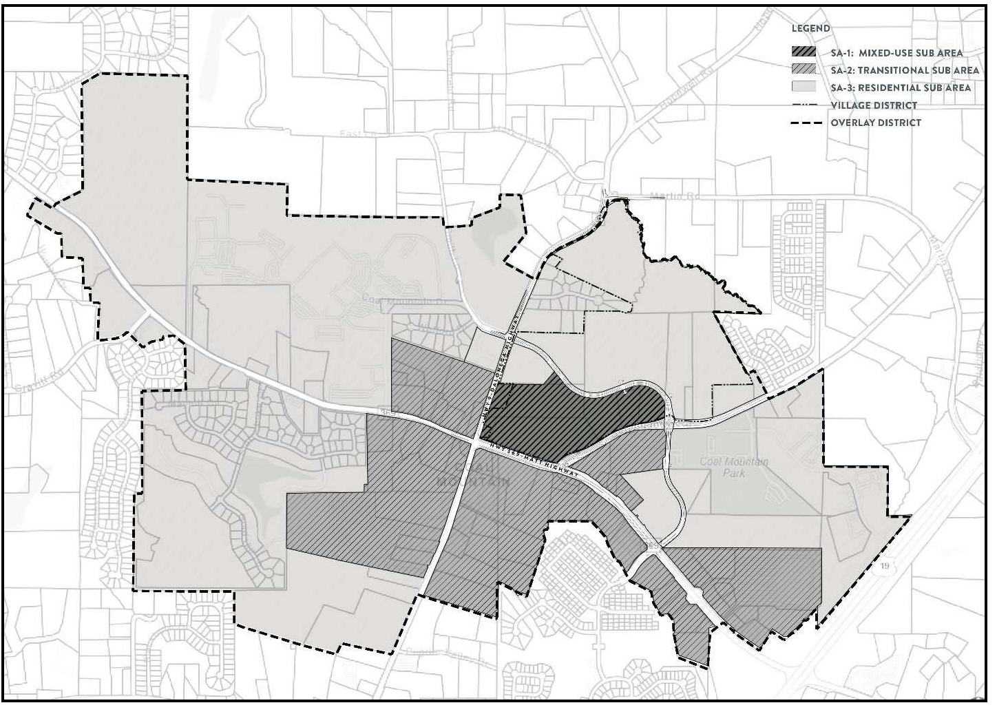
(Amd. of 3-15-2023)
21-13.3. - Design review procedures and guidelines.
Design review for development within the Coal Mountain Town Center Overlay shall be performed by staff with the input and assistance of the design review architect. The design review architect has been established and shall be appointed by the board of commissioners from time to time. All plans shall address and conform to all provisions set forth under chapter 21, article XIII. Any numerical nonconformance to the standards contained within this article shall require the submittal of a variance application in accordance with section 8-6.4 of this Code. Should a design not meet the non-numerical standards contained within this article, then the proposed design must be submitted, for public hearing, to the Forsyth County Board of Commissioners for review and approval as an alternate design. In considering whether to approve such alternate design, the board of commissioners shall consider the special considerations set forth in section 85.5(F)(2)(b) of this Code. See chapter 7 and chapter 18 for land disturbance and building permit procedures.
A design review architect has been established for the purpose of reviewing plans and/or permit applications to ensure consistency with the Coal Mountain Town Center Overlay. The design review architect shall review plans and/or permits for compliance with sections 21-13.4 through 21-13.8 of this Code. Upon the completion of the review process, the design review architect shall issue a certificate of design approval for development plans that are consistent with the Overlay.
(a)
Applicability.
(1)
Applications for building permits and corresponding land disturbance permits, involving exterior work, for multifamily dwelling units.
(2)
Applications for building permits and corresponding land disturbance permits, involving exterior work, for non-residential land uses.
(3)
Applications for building permits, involving exterior work, for single family dwelling units that are part of a subdivision platted after the adoption of the Coal Mountain Town Center Overlay.
(4)
Applications for rezonings and conditional use permits for both residential and non-residential uses as outlined below.
(b)
Submission requirements. All applicants must provide the following:
(1)
Colored, conceptual renderings of all facades for non-residential and multi-family buildings and of front facades for attached and detached single family dwelling units shall be submitted with any rezoning or conditional use permit application.
(2)
Dimensioned and colorized elevations. Colored, scaled, and dimensioned exterior elevations of all façades of non-residential and multi-family buildings identifying and representing the locations and color of all proposed exterior materials are required. For attached and detached single-family dwelling units, the same is required for front elevations only. The locations of all proposed building mounted light fixtures, equipment, or other accessories must be included for all elevations. The design review architect reserves the right to request enlarged details of portions of the building to better understand the mingling of style, materials, and colors.
(3)
Non-residential and multi-family building plans shall show all four exterior elevations. The front elevation shall be drawn at one-fourth-inch scale and the other three elevations at one-eighth-inch scale including all openings, patio, balcony or deck locations and exterior mechanical placements. For attached and detached single-family dwelling units, only the front exterior elevations are required.
(4)
Materials and finishes. Exterior materials and finishing color schedules shall be provided and shall include the type and color of all roofing material, siding, stucco, shake/shingle, stone, brick, composite, or other material for each elevation. The Design Review Architect reserves the right to request physical samples of any exterior finished material.
(5)
Equipment location and sight line study. Applicant must indicate on the drawings the proposed location of all roof top mounted equipment.
(6)
Conceptual plans for signage, landscape, and lighting.
(7)
Conceptual information on the location of driveways, walks, patios, decks, and fencing.
(8)
Such other information as is reasonably necessary to represent the character, nature and exactness of the proposed project being reviewed.
(c)
Modification Review Procedures. Approval of the design review architect must be obtained for any changes to the exterior of a multifamily or nonresidential structure. Any such approval shall be documented with the issuance of a certificate of design approval.
(d)
Final renderings of facades shall be approved by the district commissioner.
(e)
Fees. Fee amounts will be determined and set by the board of commissioners periodically.
(Amd. of 3-15-2023)
21-13.4. - Design standards.
(a)
Multi-family and nonresidential development.
(1)
Architectural standards.
a.
Massing and articulation. The term massing refers to the perception of the general shape, form, and size of a building. Articulation is a method of accentuating smaller architectural components to emphasize strategic breaks in large expanses of building surfaces. Buildings should be designed with the following principles.
b.
Building entries. Entrances should be architecturally interesting and easily recognizable to create a sense of arrival. Building entries may be identified by hierarchical massing, contrasting architectural styling, or prominent architectural elements, such as overhead structures, arbors, roof overhang, canopy or awning.
c.
Building corners and terminating vistas. Emphasize important building corners and terminating vistas by making them unique.
d.
Above street-level architectural interest. Utilize balconies, window bays, and roof overhangs to add articulation and create visual interest in the façade plane. Vegetation on walls can be used to create a break in massing and articulate façade plane depth as well.
e.
Upper and lower-level relationship. Street level and upper levels should incorporate unifying style elements. Where single level buildings and multi-level buildings are adjacent to each other, establish unifying or complementing style elements to integrate the structures and create visual interest.
f.
Rooftop interest. Rooftop seating and dining is encouraged as it adds to the overall experience of the development and creates interest from the street level.
g.
Prohibited design elements. Mobile buildings and non-permanent architectural design elements are prohibited.
(2)
Style. The architectural building style of the overlay is eclectic and intended to be solid, timeless, and enduring. Permitted architectural styles are listed below and the design of new buildings shall be based on one of the identified architectural styles as further detailed in the Coal Mountain Town Center Overlay Character Book.
a.
Industrial vernacular.
b.
Post-modern industrial eclectic.
c.
Main Street mercantile.
(3)
Street-level architecture. Street-level architecture should be varied, visually distinct from upper levels, and enhance the experience of the public realm. In limited areas, full height elements can be used to frame overall building architecture. Design elements such as entries, windows, balconies, awnings, and bays can all be used to provide visual interest.
a.
Variation in level. A visual distinction between street level and upper level(s) should be created using protruding elements, variation of materials and colors to create contrast or articulation in the vertical plane. Street level should have more detailing than upper levels.
b.
Unique character. Storefronts should create variety, spark visual interest, and portray tenant identity. This can be achieved by utilizing different materials, colors, and design elements.
c.
Pedestrian scale. A comfortable scale for the pedestrian should be created by using design elements, materials, and fenestration that relate to the street level.
(4)
Materials. The following shall apply:
a.
Primary materials. Acceptable primary finish materials shall consist of brick, stone, cast stone, cementitious siding, architectural metal siding, and glass or equivalent material as determined by the director of planning and community development. A minimum of 75 percent of each façade shall be constructed of primary materials.
b.
Secondary materials. Acceptable secondary façade materials shall consist of all primary materials as well as cement-based stucco, lap siding and shingles, architectural metal siding, synthetic stucco/EFIS, glass block, and cast stone concrete elements. No more than 25 percent of each façade shall consist of secondary materials.
c.
Accent materials. Acceptable accent materials that may be used for trim, details, soffits, eaves, and other accent areas shall be limited to aluminum and other durable metals.
(5)
Colors. The use of muted, subdued, or earth tone colors are required for all buildings and associated structures. Vending and ice machines, lock boxes and other dispensing equipment visible from the public right-of-way shall use only earth tone and/or neutral colors. Fuel dispensing units visible from the public right-of-way shall feature earth tone and/or neutral colors in their overall design. Notwithstanding the foregoing requirement, small functional parts of the fuel dispensing units and reasonable safety features may utilize additional colors for enhanced visibility and safety purposes, subject to the discretion of the director. In addition, any wall or fence shall use only earth tone and/or neutral colors. Earth tone colors refer to browns, umbers, sienna, or terracotta and brick tones. Neutral colors refer to blacks, whites, beiges, or grays. Fluorescent colors and those bright in intensity are prohibited. Glass, unpainted metal, natural stones, and sign faces are excluded from the color requirements.
(6)
Windows. A minimum of 65 percent window coverage is required for street level elevations on all retail based mixed-use façades.
a.
Measurement. Requirements for windows are measured as a percentage of the façade on a per floor basis.
b.
Distribution. Windows shall be distributed so that no rectangular area is greater than 30 percent of any story's façade area, and no horizontal segment of a story's façade greater than 30 feet in width is windowless and violates the required minimum percentage. The rectangular area of the façade shall be measured from the ground plane to the top of coping.
c.
Transparent glass. All window glass shall be highly transparent with low reflectance. Light transmission shall be a minimum of 60 percent for ground story windows and a minimum of 55 percent for upper story windows. However, deviations within five percent of these percentages shall be allowed.
(7)
Roof styles and materials. Flat roofs and sloped roofs are permissible.
a.
Parapets. Parapet walls shall screen all roof-mounted equipment. They shall be finished on any side visible from the street, rear, or side yards with materials compatible with those predominantly used on the building.
b.
Sloped roofs. If a sloped roof is used, architectural shingles, standing seam metal, or specialty metal shingles are to be used.
(8)
Building equipment. Building systems such as HVAC units, generators, transformers, utility meters, and other similar equipment shall be screened from view from public rights-of-way and public areas. The following shall apply to building equipment:
a.
Location. Building systems shall be located at the rear of the building or on the roof to minimize their view from the public right-of-way and public areas.
b.
Screening.
1.
Wall-mounted and ground mounted equipment shall be screened by an opaque wall to match the building, evergreen plantings, or a combination of wall and evergreen plantings. Walls shall be a minimum height of eight feet.
2.
Roof-mounted equipment shall be located or screened to eliminate visibility from public rights-of-way and public areas.
(9)
Landscape features. Landscape features shall be used to enhance and complement buildings, structures, and monument signs, strengthen vistas and lines of sight, soften or screen views of parking areas, and provide shade. Equal attention shall be given to landscaping along the sides and back of buildings as well as the front. The following landscape guidelines shall apply:
a.
Selections from Table 21.12, The Coal Mountain Overlay Approved Plant List, shall be utilized as primary plant materials, comprising no less than 80 percent of the development's plant palette (measured by the number of plants in any single phase of development).
b.
Where existing topographic patterns contribute to the beauty and utility of a development, they shall be preserved.
c.
Landscape treatment shall be provided to complement building architecture, structures, and monument signs, as well as strengthen vistas, screen parking areas, and provide shade.
d.
Decorative landscape elements shall be provided near building entrances and patios to enhance building architecture and surroundings. Such elements, including but not limited to, planting beds, large durable pots, stained concrete, and/or glass fiber reinforced concrete shall be used. Plastic pots are not permitted.
e.
Monument signs shall not displace required landscaping. All buildings shall include a minimum of one pedestrian bench and one trash receptacle, which shall be properly maintained and in good working condition.
(10)
Hardscape. The following shall apply:
a.
Variations in material and color shall be used around planters to define spaces within the streetscape.
b.
Planters, whether at grade or raised, shall be defined by a decorative edge.
c.
Crosswalks shall utilize decorative paving and shall contrast with the paving of the street.
d.
Parking areas shall be clearly demarcated from pedestrian connections with pavers, stamped concrete or other material that differentiates the pedestrian walkway from the parking areas.
e.
Paved pedestrian connection from public sidewalk(s) to the site interior shall be provided. This may not lessen required planting square footage within a required tree island.
(11)
Access standards. These regulations intend to provide safe and convenient vehicular and pedestrian access within and between developments, and to lessen traffic congestion and increase connectivity.
a.
Pedestrian facilities. Pedestrian access between adjacent sites and to properties external to the overlay district shall be provided wherever practical. Vehicular driveways, parking areas and parking drive lanes, loading areas, and bike lanes are not permitted to be designated as pedestrian routes.
b.
Driveway access. Driveways wider than 24 feet are required to provide refuge islands with a walk area to reduce the crossing to no more than 24 feet.
c.
Surface parking. Surface parking lots are not permitted within a setback. Parking shall be set back from a lot line abutting another property a minimum of five feet.
(12)
Buffers. An exterior buffer of 40 feet shall be required where all non-residential development abuts residential. When existing buffer areas are sparsely planted or if they are disturbed by grading or infrastructure, they shall be enhanced with additional plant material to provide an opaque screen within two years of planting.
(13)
Service, loading and trash facilities. Service, loading, and trash facilities shall adhere to the following:
a.
Location. Service and loading facilities shall be located to the sides or rear of the building to minimize the view from the public right-of-way.
b.
Orientation. No service, loading, or trash facilities shall face the right-of-way, including service and loading bays that utilize overhead doors.
c.
Screening. When visible from public rights-of-way, streets, major parking lots, or adjacent to open spaces, trash facilities shall be enclosed on three sides by masonry walls to match the building and an opaque metal gate on the fourth side. Walls and gates shall be a minimum height of eight feet. All dumpsters and compactors shall be equipped with lids.
(14)
Tenant signage. Tenant signage shall be used to maximize the storefront's architectural character and express tenant brand. Signage shall be creative and well-designed, compatible with the surroundings, and integrated into the tenant's storefront. A variety of signage types, shapes, sizes, materials, and color is encouraged within the limitations of the Forsyth County Sign Ordinance.
(15)
Art. Building art, including tenant signage via murals or painted logos is encouraged, however, the Forsyth County Signage Ordinance shall apply.
(b)
Attached and detached single family residential.
(1)
Architectural standards. These criteria apply to all front façades visible from public rights-of-way, streets, alleys, major parking lots, or adjacent to open spaces.
(2)
Style. The residential architectural building style is eclectic and is intended to allow for a variety of architectural styles. Permitted architectural styles are listed below and the design of new buildings shall be based on one of the identified architectural styles as further detailed in the Coal Mountain Town Center Overlay Character Book.
a.
American Bungalow.
b.
Art deco and art moderne.
c.
Beaux arts.
d.
Dogtrot.
e.
Federal.
f.
Folk victorian.
g.
Georgian.
h.
Greek revival.
i.
Italianate.
j.
Jeffersonian classicism.
k.
Modern farmhouse.
l.
Queen Anne.
m.
Second empire.
n.
Stick style.
(3)
Materials. The following shall apply:
a.
Primary materials. Acceptable primary finish materials shall consist of brick, stone, cast stone, and wood and/or cementitious lap siding, board and batten, shake siding and shingles or equivalent material as determined by the director of planning and community development. A minimum of 70 percent of each façade shall be constructed of primary materials.
b.
Secondary materials. Acceptable secondary façade materials shall consist of all primary materials as well as cement-based stucco, and architectural metal panels. No more than 30 percent of each façade shall consist of minor materials.
c.
Accent materials. Acceptable accent materials that may be used for trim, details, soffits, eaves, and other accent areas shall be limited to aluminum and other durable metals, and wood.
d.
Prohibited materials. Prohibited materials include vinyl siding, and synthetic stucco/EFIS.
(4)
Colors. All exterior surfaces on structures visible from public rights-of-way shall be neutrals or earth tones. Neutral tones refer to whites, blacks, beiges, or grays, while earth tones refer to browns, umbers, sienna, or terracotta and brick tones. Bright or fluorescent colors are prohibited. Natural stone, and unpainted metal and glass are excluded from the color requirements.
(c)
Single family garages.
(1)
Attached houses.
a.
No residential driveway shall have direct access to Highway 9 (Dahlonega Hwy) or Highway 369 (Brown's Bridge Road) without approval of the Director of Engineering.
b.
Garages for attached houses (townhouses) may be rear-loaded, side-loaded, or front-loaded, in accordance with this section.
c.
Rear-loaded garages may be attached or detached. Rear-loaded detached garages shall be set back at least five feet from the alley right-of-way.
d.
Front and side-loaded garages.
1.
Front-loaded garages that exceed 50 percent of the width of the dwelling unit shall not have garage doors wider than 16 feet.
2.
Vehicle entrances to all front and side-loaded garages shall be setback at least 18 feet from the right-of-way.
3.
When garages for two or more dwelling units are paired (abutting), driveways shall be combined and centered on the property line between the garages. In all cases, driveways serving front or side-loaded garages for single-family attached units shall be designed to ensure a reasonable amount of uninterrupted curb length between single or paired driveways.
(2)
Detached houses.
a.
No residential driveway shall have direct access to Highway 9 (Dahlonega Hwy) or Highway 369 (Brown's Bridge Road) without approval of the Director of Engineering.
b.
Garages for detached houses may be rear-loaded, side-loaded, or front-loaded, in accordance with the regulations of this section.
c.
Rear-loaded garages may be attached or detached. Rear-loaded detached garages shall be set back at least five feet from the alley right-of-way.
d.
Side-loaded garages may be attached or detached. Side-loaded garages may be accessed by a driveway leading from a side street or from the front street. Vehicle entrances to all side-loaded garages shall be set back at least five feet from the right-of-way.
e.
Vehicle entrances to all front-loaded garages shall be set back at least 18 feet from the right-of-way.
f.
Front-loaded garages that exceed 50 percent of the width of the dwelling unit shall not have garage doors that are wider than 16 feet.
(Amd. of 3-15-2023; Amd. of 11-2-2023)
21-13.5. - Open space.
(a)
Required open space. A minimum of 20 percent of the total site area shall be open space. Open space calculations shall exclude rights-of-way. Density and open space shall be calculated based on the same number of acres.
(1)
Calculation of open space. The following elements may be included in calculating open space within the overlay:
a.
Conservation areas. Any combination of conservation areas that together form a permanent, undevelopable area.
b.
Areas for pedestrian amenity or aesthetic appeal, which may include, but is not limited to, plazas, squares, terraces, patios, fountains, sidewalks, common areas and open spaces for outdoor recreation and similar public amenities.
c.
Wetlands, creeks, streams and their tributaries, and floodplain areas, when not located within detached single-family lots.
d.
Detention ponds and stormwater management areas when designed as an amenity and intended for the use and enjoyment of the public.
e.
Areas within multi-family residential developments designed and intended for the use and enjoyment of the residents or the public.
(2)
Types of open space. Open spaces may vary based on intended use, size, microclimate, and adjacent buildings and uses. Types of open space may include:
a.
Civic plazas and squares.
b.
Sidewalks, trails, and other pedestrian amenities.
c.
Community parks and amenity areas.
d.
Pocket parks.
e.
Neighborhood amenities.
f.
Recreational amenities.
g.
Social spaces.
h.
Paseos.
i.
Mews.
(Amd. of 3-15-2023)
21-13.6. - SA-1 mixed use subarea.
The SA-1 mixed use subarea intends to create a mixed-use environment that is high quality, community scaled, and pedestrian focused. A variety of uses are permitted when the appropriate zoning and/or conditional use permit is obtained, however a complementary mix of attached residential, multi-family and commercial uses are highly encouraged.
(a)
Building heights.
(1)
Buildings. Building height shall be limited to a maximum of eight stories, not to exceed 125 feet above grade.
(2)
Parking structures. Parking structures may be free standing or integrated with a multi-family wrapped product. When free standing, parking structures shall be limited to a maximum of five levels. When integrated with residential, parking structures shall be limited to a maximum of six levels and are required to be wrapped with residential units on all sides visible from public rights-of-way and open spaces.
(b)
Open space. Open space areas within SA-1 mixed-use subarea shall provide a variety of civic spaces that can accommodate different scaled events from large, organized events, to small, informal gatherings. The following types of open space are encouraged within the SA-1 mixed-use subarea:
(1)
Civic plaza. The civic plaza shall be designed utilizing a blend of hardscape and landscape areas to provide versatility for a variety of event types and sizes. The minimum contiguous area for the civic plaza shall be 20,000 square feet.
(2)
Social spaces. Intended to complement the central civic plaza, a series of smaller, passive gathering spaces shall be incorporated to provide opportunities for people to socialize in a more intimate manner. These spaces may include casual seating areas, fire pits, and play areas.
(3)
Paseos. These pedestrian spaces provide connectivity through a block or building, or serve to connect the sidewalk with parking areas behind buildings. Paseos also provide areas for outdoor seating and may or may not be covered by buildings spanning above. Private dining areas within paseos will not be included in the calculation of open space.
(4)
Open space elements. Design elements that activate and provide unique identity to open spaces are encouraged. Elements may include:
(a)
Shade structures.
(b)
Water features.
(c)
Fire pits.
(d)
Seating, including tables and chairs, fixed or movable, benches, swings, and seat walls.
(e)
Sculptures.
(f)
Structures for play or flexible areas for games.
(Amd. of 3-15-2023)
21-13.7. - SA-2 transitional subarea.
The SA-2 transitional subarea intends to create an intermediary zone between the mixed use and residential subareas. A variety of uses are permitted when the appropriate zoning and/or conditional use permit is obtained, however a complementary mix of single-family homes and commercial uses are highly encouraged.
(A)
Building heights.
(1)
Buildings. Building height shall be limited to a maximum of four stories, not to exceed 65 feet above grade.
(2)
Parking structures. Parking structures may be free standing or integrated with a multi-family wrapped product. When free standing, parking structures shall be limited to a maximum of three levels. When integrated with residential, parking structures shall be limited to a maximum of four levels and are required to be wrapped with residential units on all sides visible from public rights-of-way and open spaces.
(b)
Open space. Open space in the SA-2 transitional subarea shall provide residents with a variety of neighborhood scaled green spaces and amenities. The layout of streets and lots shall incorporate these open spaces as centralized, organizing elements that are focal points in the design of the community. The following types of open space are encouraged within the SA-2 Transitional subarea:
(1)
Community amenity areas. Community amenities may include elements such as community clubhouse/pavilion, pools, play areas, and tennis/sports courts.
(2)
Pocket parks. Pocket parks may range in size and provide elements such as open lawns, hardscape plazas, gardens, water features, pavilions, trellises or overhead structures, and playgrounds.
(3)
Mews. Mews are garden spaces defined by buildings on a minimum of two sides that create semi-private open space and gives a unique identity to the fronting homes.
(4)
Paseos. Paseos shall be used to provide inter-block connectivity to open space areas and trails. These pedestrian spaces provide connectivity through a block or building, or serve to connect the sidewalk with parking areas behind buildings. Paseos also provide areas for outdoor seating and may or may not be covered by buildings spanning above. Private dining areas within paseos will not be included in the calculation of open space.
(Amd. of 3-15-2023)
21-13.8. - SA-3 residential subarea.
The SA-3 residential subarea envisions a series of walkable, cohesive residential neighborhoods. A variety of uses are permitted when the appropriate zoning and/or conditional use permit is obtained, however attached and detached single family homes are highly encouraged.
(a)
Building heights.
(1)
Buildings. Residential building heights shall be limited to a maximum of three stories, not to exceed 40 feet above grade.
(b)
Open space. Open space areas within the SA-3 residential subarea shall provide residents with a variety of neighborhood scaled green spaces and amenities. The layout of streets and lots shall incorporate these open spaces as centralized, organizing elements that are focal points in the design of the community. The following types of open space are encouraged within the SA-3 residential subarea:
(1)
Community amenity areas. Community amenities may include elements such as community clubhouse/pavilion, pools, play areas, and tennis/sports courts.
(2)
Pocket parks. Pocket parks may range in size and provide elements such as open lawns, hardscape plazas, gardens, water features, pavilions, trellises or overhead structures, and playgrounds.
(3)
Mews. Mews are garden spaces defined by buildings on a minimum of two sides that create semi-private open space and gives a unique identity to the fronting homes.
(4)
Paseos. Paseos shall be used to provide inter-block connectivity to open space areas and trails. These pedestrian spaces provide connectivity through a block or building, or serve to connect the sidewalk with parking areas behind buildings. Paseos also provide areas for outdoor seating and may or may not be covered by buildings spanning above. Private dining areas within paseos will not be included in the calculation of open space.
(Amd. of 3-15-2023)
21-14.1. - Purpose.
It is the goal of this overlay to support non-residential development while establishing a baseline for design compatibility. This is accomplished through enhancement of businesses via unity of design, quality architecture, and the creation of visual interest through landscaping. The overlay district establishes minimum standards for development intended to produce buildings that augment the appearance of the area, encourage corridor landscaping for aesthetic benefit, and contribute to the district's overall character.
(Amd. of 11-7-2024)
21-14.2. - Delineation of district.
The North Georgia 400 Overlay District applies to properties indicated on the Official Overlay District Map of Forsyth County. Where land is located in the North Georgia 400 Overlay District, the regulations governing development in the overlay district shall apply in addition to the regulations governing development in the underlying base zoning district. In the event of an express conflict between the standards governing a base zoning district or the Forsyth County Sign Ordinance and those governing this overlay district, the standards governing the overlay district shall control.
(Amd. of 11-7-2024)
21-14.3. - Permitted uses.
All uses allowed in the underlying zoning districts as established by this Code are permitted in the North Georgia 400 Overlay District.
(Amd. of 11-7-2024)
21-14.4. - Design plan administrative review.
Design review for development within the North Georgia 400 Overlay shall be performed by staff. All plans shall address and conform to all provisions set forth under chapter 21, article XIV. Any numerical nonconformance to the standards contained within this article shall require the submittal of a variance application in accordance with section 8-6.4 of this Code. Should a design not meet all of the non-numerical standards contained within this article, then the proposed design must be submitted, for public hearing, to the Forsyth County Board of Commissioners for review and approval as an alternate design. In considering whether to approve such alternate design, the board of commissioners shall consider the special considerations set forth in section 8-5.5(f)(2)(b) of this Code. Architectural elevations, exterior finish schedules, and landscape plans must be submitted to the department at the time of application for a land disturbance permit. See chapter 7 and chapter 18 for building permit and land disturbance procedures.
(Amd. of 11-7-2024)
21-14.5. - Site design standards.
(a)
Access. Access standards are intended to provide safe and convenient vehicular and pedestrian access within developments and between adjacent developments and to lessen traffic congestion and increase connectivity.
(1)
New developments and substantial improvements to existing developments shall provide for pedestrian and automobile access connections between adjacent properties and shall prepare and have recorded in the real property records of the county cross access connection easements to confirm such access. The director shall have the discretion to waive this requirement if the anticipated land uses are incompatible.
(2)
Parcels and buildings must be arranged and designed so as to allow for the opening of future streets and must provide access to those areas not presently served by streets. No development may be designed to completely eliminate street access to abutting parcels.
(3)
The stub-out street right-of-way, pavement, and curbing must extend to the boundary of the abutting parcel at the point where the connection to the anticipated street is expected.
(4)
If a stub-out street exists next to an abutting parcel, the street system of any new or substantially renovated development must connect to the stub-out street to form a through street.
(5)
The department may eliminate the requirement for a stub-out street or require pedestrian and bicycle-only access when steep slopes in excess of 25 percent, freeways, waterways, tree conservation areas, stream buffers, cemeteries, open space or easements would make the provision of a stub-out street infeasible.
(6)
Where pedestrian crossings must cross parking areas and drives, decorative paving material (i.e., pavers, stamped or textured concrete, or color concrete) shall be used to delineate the pedestrian crossing.
(b)
Landscaping. Plant material and design decisions are to be complementary to architectural features and integral to the beauty of the area. Landscape plans shall be submitted to the department for design review. These standards shall apply to all properties, unless otherwise specified herein, and are required in addition to Ordinance No. 98 (Tree Protection and Replacement Ordinance) as well as any required buffer:
(1)
Plantings shall be compatible with regard to species selection and must provide a cohesive transition between landscape areas.
(2)
Properties located along Georgia Highway 400 must meet applicable planting requirements in section 10-1.10 of this Code.
(3)
For all other properties, a minimum 20-foot wide landscape strip shall be installed along existing or proposed rights-of-way for all development within the North Georgia 400 District; except that to the extent a specific zoning designation establishes a greater landscape strip requirement than this overlay, the larger requirement shall control. These landscape strips shall be located behind utility easements so plant material will not be disturbed after installation. The following shall apply:
a.
Landscape strips shall be composed of trees, shrubs and/or herbaceous plants. The remaining ground area shall be sodded, seeded, or hydroseeded with grass and/or planted with groundcover species.
b.
A minimum of 40 percent of all installed trees and shrubs in the landscape strip shall be evergreen plant material.
c.
Landscape strips shall include a minimum of two trees and six shrubs per 50 linear feet, with a minimum of 60 percent overstory requirement. Trees shall count towards the tree density requirements in Ordinance No. 98 (Tree Protection and Replacement Ordinance).
d.
Overstory trees shall have a minimum three-inch caliper and at least ten-foot height at time of installation. Understory trees shall have a minimum two-inch caliper and at least eight-foot height at time of installation. All proposed shrubs shall be a minimum of two feet high at the time of planting.
e.
Landscaping may be informal with multiple species arranged in naturalistic clusters.
(4)
Plant materials shall be used as accent elements at roadside entryways to provide a definite sense of arrival to businesses. Plant materials shall consist of ground cover, herbaceous ornamentals, shrubs, understory, and/or overstory trees adjacent to the establishment's monument sign(s). These materials shall be clustered while maintaining adequate sight distance to and from the entryway.
(5)
For residential projects fronting Georgia Highway 400, a landscaped entrance median shall be required. Planting shall include a combination of perennials, annuals, and shrub material. The use of understory trees is encouraged.
(6)
All landscape designs shall incorporate a minimum of 50 percent plant material indigenous to the Southeastern U. S. and be approved by the County arborist.
(7)
The current property owner shall be responsible for maintenance of required landscaping. All dead and damaged plant material within landscaped areas must be replaced with a similar species within one month. If weather conditions are not appropriate for replanting, the property owner may postpone replacement for up to six months. For replacement of large overstory trees, the size of replacement trees shall exceed the minimum size required at initial installation by at least one caliper but is not required to be of similar size to the trees being replaced.
(c)
Civic space. The inclusion of civic space in future site development is highly desired. Examples of civic space include but are not limited to a passive or active park, pocket park, square, plaza, playground, as well as the inclusion of public art installations.
(d)
Building placement.
(1)
Non-residentially zoned properties located along Georgia Highway 400 must meet applicable setback requirements in section 10-1.10 of this Code.
(2)
For residential projects located along Georgia Highway 400, a minimum 200-foot building setback is required.
(3)
For commercial and office zoning districts, the principal entrance of a building shall be located on the side of the building facing a public street. Lots with double frontage shall provide orientation and principal entrance(s) on facades along the highway or major street.
(E)
Delivery and ride-share parking. Establishments that are serviced by ride-share, courier, or other delivery services shall take affirmative steps to ensure such services comply with parking requirements and do not impede the flow of traffic.
(f)
Bicycle parking. For non-residentially zoned properties, one bicycle rack per 50 parking spaces, but no less than one, is required for every building. A rack shall consist of a fixed location for locking at least two bicycles.
(g)
Buffers. Excluding stream buffers, buffers may be disturbed for grading and development of a site but shall otherwise meet the requirements of Forsyth County Buffer Standards.
(h)
Screening. The following standards are required for all non-residentially zoned property in addition to the regulations set forth in chapter 12 and chapter 14:
(1)
All parking areas shall be screened from view of the right-of-way of the highway or major street with evergreen shrubs. Shrubs shall reach no less than three feet in height as measured from the top of curb of the parking area.
(2)
All dumpsters and compactors shall be enclosed on three sides by materials and architectural elements to match the primary structure and gated on the fourth side.
a.
The enclosure shall be at least one foot taller than the highest point of the dumpster or compactor.
b.
The opening of the enclosure shall measure a minimum of 12 feet in width.
c.
The gate shall be composed of decorative metal or other durable materials which shall reach the height of the three-sided enclosure and with colors coordinated with those of the primary structure. Chain link material is prohibited.
d.
All dumpsters and compactors shall be equipped with lids.
e.
A 60-foot maneuvering apron is required adjacent to the enclosure's gate.
(3)
Drive-throughs.
a.
No drive-through shall exit directly onto the right-of-way.
b.
Service windows are prohibited from facing a public right-of-way.
c.
Car wash openings shall be oriented away from any public right-of-way.
(4)
Businesses requiring a fleet of service vehicles shall park such vehicles to the rear of the building or otherwise provide adequate screening to ensure the vehicles are not visible from the public right-of-way.
(5)
Storage of shopping carts shall be located indoors. Where indoor storage is not feasible, shopping carts shall be located adjacent to the building and screened by an enclosure made of masonry to match the exterior building materials.
a.
Shopping cart corrals in parking areas shall be curbed within parking islands so that additional railings are not required for secure cart positioning.
b.
Parking islands that contain cart corrals must include 400 square feet of landscaped space.
c.
One identifying sign at the rear of each corral is permitted for visibility within the parking lot.
(6)
Mechanical equipment at ground level shall be screened from the public right-of-way and pedestrian paths by opaque walls, or fencing and a screen of evergreen shrubs.
(7)
Stormwater detention and retention ponds that require a fence must not be visible from the public right-of-way unless a 20-foot planted buffer is provided outside of the required fencing. Access to stormwater ponds shall not be facing the public right-of-way.
(Amd. of 11-7-2024)
21-14.6. - Signage.
When a nonconforming sign is altered, the sign structure and base materials shall come into compliance with the Forsyth County Sign Ordinance as well as the color requirements within section 21-14.7(b). An alteration shall include but is not limited to any change to the size or height of the sign, the structural replacement, and/or relocation of a sign. In addition to Ordinance No. 74 (Sign Ordinance), the following shall apply:
(a)
Temporary signs, including inflatable or forced-air signs, tarps, banners, sign dancers, and any sign mounted on wheels, are prohibited within the boundary of the North Georgia 400 Overlay. Permanent and temporary signs in windows are also prohibited.
(b)
Wall signs and monument signs shall not be of the singular plastic insert or panel sheet variety. Channel letters are strongly encouraged for both monument and wall signs. If internally illuminated, lettering shall be individually formed and lighted.
(c)
Monument sign structure and base materials shall be compatible with the color, texture, material, and architectural design of the principal building.
(1)
For non-residentially zoned properties, monument signs shall incorporate brick or stone enframement of the sign face for a minimum of 50 percent of the sign face perimeter. Enframement materials shall abut the sign face without any designed voids or other decorative elements intended to visually separate the space between the sign face and enframement.
(d)
Electronic message boards (EMBs) or changeable copy signs are permitted only for fuel station monument signs, one per road frontage. The total electronic or changeable copy area for each sign shall not exceed 46 square feet.
(e)
Wall mounted raceways shall be painted to match the adjoining structure.
(f)
Fuel station canopy signs are allowed, one per road frontage not to exceed 20 square feet. Signs must be flush against the canopy fascia. Banding of corporate colors shall be considered part of the sign and shall count toward the allowable 20 square feet.
(Amd. of 11-7-2024; Amd. of 5-1-2025)
21-14.7 - Architectural design standards.
The architectural design standards established herein are intended to contribute to the overall character of the overlay district. The architectural criteria listed below establish minimum design standards within the overlay district in order to reduce the impacts of development on adjacent properties. These standards are required for all non-residentially zoned properties in addition to the design criteria contained in chapters 12 and 14:
(a)
Building materials shall comply with the requirements of Table 21.14.
Table 21.14
(b)
The use of muted, subdued or earth tone colors are required for all buildings and associated structures. Vending and ice machines, lock boxes, and other dispensing equipment visible from the public right-of-way shall use only earth tone and/or neutral colors. Fuel dispensing units visible from the public right-of-way shall feature earth tone and/or neutral colors in their overall design. Notwithstanding the foregoing requirement, small functional parts of the fuel dispensing units and reasonable safety features may utilize additional colors for enhanced visibility and safety purposes, subject to the discretion of the director. In addition, any wall or fence shall use only earth tone and/or neutral colors. Earth tone colors refer to browns, umbers, sienna, or terracotta and brick tones. Neutral colors refer to blacks, whites, beiges, or grays.
(c)
The principal entrance of a building shall be articulated and express greater architectural detail than other portions of the building. Building entries shall be identified by hierarchical massing, contrasting architectural styling, or prominent architectural elements, such as overhead structures, arbors, roof overhang, or canopy.
(d)
Buildings shall be designed to avoid large, uninterrupted facades. Window and door openings, varied front façade setbacks, material variation, a palette of colors, a variety of roof types, tower features, parapets, awnings, cornices, canopies, corbels, bandings, moldings and other architectural embellishments and details shall be used to promote architectural features that prevent monotony.
(e)
Façades over 100 feet in length must incorporate wall projections or recesses a minimum of six inches in depth. The combined length of said recesses and projections must constitute at least 20 percent of the total façade length.
(f)
Variation in the roofline of buildings and offsets in pitched roofs and gables are required. Parapets in individual building facades exceeding 100 continuous linear feet must be varied in height and projection and must use decorative elements such as crown moldings, dentils, brick soldier courses, or similar details.
(g)
Burglar bars, fiberglass awnings, and steel-roll down curtains are prohibited.
(h)
Structured parking facilities shall consist of materials and architectural elements that complement the primary structure.
(i)
Covered structures within parking lots are prohibited.
(j)
Retaining walls shall be faced with stone, brick, or a material that is complementary to the primary building, when visible from the right-of-way.
(k)
Sidewalks, no less than five feet, shall be provided along the full length of the building along any facade featuring a customer entrance and along any facade abutting public parking areas.
(l)
Fencing. Fencing materials shall be designed to contribute to the overall architectural character of the principal land use and shall incorporate the details below when located along any property frontage for non-residential uses or when present along entrance frontage for major subdivisions.
(1)
Unless otherwise specified by a zoning condition, fences shall be one of the following types:
a.
Black, four-board with stone or brick columns;
b.
Black "wrought-iron" in appearance.
(2)
No chain link fence shall be visible from the right-of-way.
(3)
All vinyl fencing is prohibited with the boundary of the North Georgia 400 Overlay.
(Amd. of 11-7-2024)