
Forsyth County Unincorporated
City Zoning Code
City Zoning Code
CHAPTER 19
- CONSERVATION SUBDIVISIONS
ARTICLE III. - OPEN SPACE AND CONSERVATION AREAS[21]
Editor's note— An amendment adopted April 15, 2021, amended article III in its entirety to read as herein set out. Former article III, §§ 19-3.1—19-3.10, pertained to conservation areas and open spaces, and derived from Amd. of 3-26-2001; Amd. of 9-25-2003; Amd. of 2-2-2004; Amd of 11-15-2004; Amd. of 11-1-2007; Amd. of 12-1-2011; Amd. of 1-4-2018; Amd. of 4-4-2019; Amd. of 11-7-2019; Amd. of 1-20-2021.
ARTICLE V. - SITE DESIGN STANDARDS[22]
Editor's note— An amendment adopted April 15, 2021, added a new article IV and renumbered article IV as article V to read as herein set out. Former article IV pertained to design standards and guidelines for lot configurations and building orientations and derived from Amd. of 9-25-2003; Amd. of 2-2-2004; Amd. of 11-1-2007; Amd. of 11-11-2012; Amd. of 1-4-2018; Amd. of 4-4-2019.
ARTICLE VI. - DESIGN STANDARDS AND GUIDELINES FOR STREETS[23]
Editor's note— An amendment adopted April 15, 2021, amended article VI in its entirety to read as herein set out. Former article VI, §§ 19-6.1—19-6.13, pertained to similar subject matter, and derived from Amd. of 2-2-2004; Amd. of 11-1-2007.
ARTICLE VII. - PROCEDURES[24]
In addition to the application procedures for zoning approval, sketch plat approval, preliminary and final plat approval, as specified in chapter 18 of this Code, conservation subdivisions shall comply with the following procedures:
Editor's note— An amendment adopted April 15, 2021, amended article VII in its entirety to read as herein set out. Former article VII, §§ 19-7.1—19-7.3, pertained to similar subject matter, and derived from Amd. of 2-2-2004; Amd. of 11-1-2007; Amd. of 12-1-2011; Amd. of 11-7-2019.
ARTICLE IX. - CRITERIA FOR APPROVAL[25]
Editor's note— An amendment adopted April 15, 2021, added a new article VIII. Therefore, article VIII is renumbered as article IX and amended to read as herein set out.
19-1.1.
This chapter is intended to provide for residential subdivisions that are designed based first and foremost on the provision and preservation of open space, but that accommodate the entire amount of development that would otherwise be legally possible under conventional subdivision designs, and that:
(a)
Minimize the environmental and visual impacts of new development on critical resources, aesthetically pleasing areas, and historically and culturally significant sites and structures;
(b)
Encourage more efficient development of land by affording greater flexibility of design and placement of buildings and structures;
(c)
Reduce infrastructure construction costs;
(d)
Contribute to an interconnected network of permanent open space in the county;
(e)
Provide for undivided open space within new developments;
(f)
Enhance quality of life for residents by creating more attractive and pleasing living environments;
(g)
Reduce the demand on public expenditures for open space, parkland, play fields, and other areas for active and passive recreation;
(h)
Minimize disturbances to streams, steep slopes, and vegetation and provide increased opportunities to maintain natural conditions; and
(i)
Meet design requirements and guidelines established in this chapter for the protection of conservation areas.
(Amd. of 2-2-2004; Amd. of 11-1-2007; Amd. of 4-15-2021)
19-2.1
It is the intent of this chapter to create and preserve open space and to provide alternative standards for the development of land to those specified in chapter 18, subdivisions and land development and those specified in chapter 11, residential districts. Provisions of chapter 18 and chapter 11 that are specifically addressed in this chapter shall not apply. However, in cases where the provisions for conservation subdivisions do not address a particular question or issue, the provisions of chapter 18 and chapter 11 shall apply.
(Amd. of 2-2-2004; Amd. of 11-1-2007; Amd. of 4-15-2021)
19-3.1. - Required specifications.
(a)
Minimum size. The minimum size of a conservation subdivision shall be 25 contiguous acres. Division of the subject property by a public road is prohibited.
(b)
Area in open space.
(1)
Each conservation subdivision shall provide a minimum of 40 percent of its total land area as open space, as defined by this Code. The amount of acreage dedicated to secondary conservation areas must equal at least 30 percent of the total primary conservation areas. If the total amount of open space provided is comprised of 60 percent or more secondary conservation area as described below, the overall total open space amount required shall be reduced to 30 percent of the total land area. Open space may be comprised of up to 100 percent secondary conservation area.
(2)
Open space shall be no less than five contiguous acres.
(3)
The width of any open space tract shall be at least 25 feet.
(4)
Exterior buffers cannot be counted towards the secondary conservation area total.
(c)
Primary conservation areas. Primary conservation areas refer to the most ecologically sensitive and often severely constrained land, including land as shown in Table 19.1. A conservation subdivision shall identify and integrate all primary conservation areas into permanent open space. Refer to figure 19.1 for guidance on the conservation subdivision design process.
(d)
Secondary conservation areas. Secondary conservation areas refer to locally noteworthy or significant features of the natural or cultural landscape and include land as shown in Table 19.1. A conservation subdivision shall identify secondary conservation areas and shall strive to integrate all or a portion of them into undivided, permanent, open spaces. "Undivided" refers to contiguous, usable open space; small strips of land remaining randomly among parcels or isolated "alley" strips do not qualify as meeting the required conservation area standards. Refer to figure 19.1 for guidance on the conservation subdivision design process.
TABLE 19.1 DEFINITIONS FOR PRIMARY AND SECONDARY CONSERVATION AREAS
(Amd. of 4-15-2021)
19-3.2. - Standards for open space.
This section provides standards and guidelines for establishing open space.
(a)
Location. When a conservation subdivision site abuts an existing conservation area, park, nature preserve, or public undeveloped land, such as the 1085 line of the U.S. Army Corps of Engineers around Lake Lanier, conservation areas shall be designed so that they are located along the common boundary line.
(b)
Trails. Open space shall provide for trails, between ten and 12 feet wide and shall be designed to connect with a sidewalk network and/or function as pathways to common area and/or amenity destinations. Trails are required to be located external to individual residential lots and are not intended to be accessed via easements through individual residential lots. No trail located within open space may include impervious materials. Motorized vehicles shall not be permitted on trails except for maintenance, construction, or public safety purposes. This prohibition shall be included within the required covenants. Where appropriate and convenient, such trails shall be made handicapped accessible. Connection to off-site county trails is strongly encouraged.
(c)
Trail/street crossings. Where trail systems cross an internal subdivision street, the access points shall be directly across from each other, clearly identified both to the motorist and pedestrian, and located with appropriate sight distance as determined by the director of engineering, subject to the approval of the engineering department. Where a trail crosses any county road not interior to the subdivision, the trail shall be grade separated (i.e., by a tunnel or bridge), or located at a traffic control device approved by the director of engineering and planning and community development director.
(d)
Limits of disturbance. No clearing or grading shall be permitted in the primary or secondary conservation areas with the following exemptions:
(1)
Encroachments for infrastructure and stormwater shall be granted only for perpendicular buffer crossings that have been reviewed and approved per chapter 18, article XI.
(2)
Removal of vegetation as identified on the United States Department of Agriculture Georgia List of Exotic and Invasive Plants is permitted provided such removal is minimal. This exemption shall not apply to undisturbed state and county stream buffers.
(e)
Tree cover. Preservation and enhancement of existing tree canopy is strongly desired and encouraged wherever possible but at minimum, must be consistent with the Forsyth County Tree Ordinance.
(f)
Permitted uses. For the purposes of this chapter, open space may be used for primary conservation area and secondary conservation area. Pervious surface trails for passive recreation may be allowed.
(g)
Active recreational facilities. Active recreational facilities, if provided, shall not be located in the primary or secondary conservation areas and shall not count toward required open space.
(h)
Golf courses prohibited. Golf courses do not comply with the conservation intent of this chapter and thus are not permitted.
FIGURE 19.1 CONSERVATION SUBDIVISION DESIGN PROCESS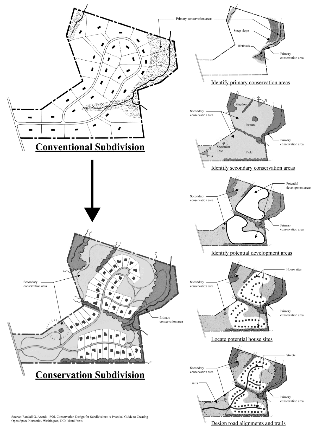
(Amd. of 4-15-2021)
19-4.1. - Maximum Number of Lots.
In conservation subdivisions, lot sizes are allowed to be smaller than permitted in conventional subdivisions. The minimum lot size shall be as provided in table 19.2 in section 19-5.1, so as to ensure that lots created will not be substantially out of character with lot sizes in conventional subdivisions within the same zoning district. The development must, however, be density neutral i.e., the overall number of dwellings allowed must be no more than the total number of dwellings a conventional subdivision layout would yield. The applicant may choose one (1) of the methods below to determine the maximum number of lots. The greater of option (a) or (b) is the maximum allowed lots.
(a)
Yield plan. A yield plan shows the site developed as a conventional subdivision and the maximum number of lots the site would theoretically yield. The design of the yield plan must be realistic and account for areas that cannot be developed such as flood plain, stream buffers and wetlands.
(b)
Adjusted tract acreage method. This calculation deducts the adjusted constrained lands from the gross tract acreage. The resulting net tract acreage is then multiplied by the zoning district density. The process for this calculation is described as follows:
(1)
Determine the constrained lands. Identify all land in the following categories:
(a)
Slopes over 35 percent of at least 5,000 square feet contiguous area.
(b)
The 100-year floodplain.
(c)
Wetlands that meet the definition of the Army Corps of Engineers pursuant to the Clean Water Act.
(d)
Area of land in stream buffers as required by federal, state or local regulations.
(e)
Area of land designated for construction of roads and associated right-of-way.
(f)
Area of all impervious surfaces associated with amenities, including but not limited to parking areas, tennis courts, swimming pools, clubhouses and other impervious surfaces.
(2)
Calculate the adjusted constrained lands by multiplying the total area of land in items (a) through (d) by 50 percent and adding 100 percent of area of land in items (e) and (f).
(3)
Determine the net tract acreage. The net tract acreage is calculated by subtracting the adjusted constrained lands from the gross tract acreage of the property to be developed.
(4)
The number of allowed lots is determined by multiplying the net tract acreage by the zoning district density as listed in Table 19.2 in section 19-5.1.
Example scenario:
100 Acre Property
10 Acres of Wetlands (x 50%)
10 Acres of Slopes (x 50%)
15 Acres of Roads/ROW/Amenity
1.5 u/a Res2 Density
(Amd. of 4-15-2021)
19-5.1.
After determining primary and secondary conservation areas. This article provides standards and guidelines for conservation subdivisions.
(a)
Performance standards shall be in accordance with table 19.2 below.
(b)
Homes shall not front directly on off-site streets.
(c)
No less than 85 percent of lots shall be entirely abutted on at least one side by open space.
(d)
All buildings and structures shall be set back a minimum of 75 feet from all primary conservation areas.
(e)
Where possible, structures shall not be placed at the top of ridge lines, and building envelopes shall not include ridge lines, in order to preserve the natural view of ridges. A ridge line shall be considered the line or surface along the top of a long narrow hilltop, mountain range, or watershed. Structures required to be sited in steeply sloping areas shall have their heights lower than the ridge line. Lots with slopes of 25 percent or more are discouraged because they: 1) may not ensure the provision of yards suitable for lawns and play areas; 2) pose challenges with respect to septic tank drain fields; and 3) pose erosion control concerns.
(f)
Fencing is prohibited unless otherwise required by State or County rules or regulations.
(g)
Conservation subdivisions in all zoning districts shall provide an exterior buffer. The size of the exterior buffer is determined by the size and zoning of the lot proposed adjacent to the exterior buffer of the conservation subdivision and shall be in accordance with table 19.3 below. In the event that the subject property is abutted by more than one zoning along a property line, the largest of the adjacent buffer sizes shall determine the buffer size required on the subject property for that property line.
(h)
Neither exterior buffers nor stream buffers shall be incorporated within individual residential lots.
TABLE 19.2 PERFORMANCE STANDARDS
*Measured from the edge of the dedicated right-of-way or from access alley easement.
Notes Table 19.2
(1)
Maximum lot coverage for the purposes of this chapter means the percentage of the lot covered by all structures including primary and any accessory buildings, however lot coverage does not include other impervious surfaces such as driveways, pools, at grade patios or at grade pool decks.
TABLE 19.3 MINIMUM EXTERIOR BUFFER
(Amd. of 4-15-2021)
19-5.2. - Sewage treatment and disposal systems.
A conservation subdivision must be served by public sewer.
(Amd. of 4-15-2021)
19-6.1. - Introduction.
This article provides standards and guidelines for designing streets serving conservation subdivisions.
(a)
Location and alignment. Designers should avoid crossing wetlands with streets where possible. Existing farm roads should be incorporated into conservation subdivision designs. Roads should follow existing contours with a minimum of cut and fills and disturbance for construction. In cases where agricultural protection or meadow preservation is a primary objective, new roads should be placed along the edge of a field, rather than through the middle, so as to be less intrusive on the open space character of the tract.
(b)
Lengths and curves. The length of roads should be minimized to reduce costs and aesthetic impacts. Long, straight road segments should be avoided. Curvilinear designs are preferred for rural conservation subdivisions. Streets should be curved and aligned to produce vistas of open space elements, where possible. Short, straight, interconnected streets (i.e., grid patterns) are appropriate for clustered home sites within conservation subdivisions.
(c)
Separate travel lanes. Where necessary, the directional travel lanes should split or curve apart to protect natural features. In cases where travel lanes are split or curve apart, the minimum width of each travel lane should be ten feet in paved width.
(d)
Right-of-way and clearance. Rights-of-way should be only wide enough to accommodate the required street width improvement, adequate shoulder bases for utilities, bikeways and/or walkways, and open storm drainage ditches at appropriate bank slope. Drainage easements may be provided in lieu of expanding the right-of-way for drainage ditches if approved by the director of engineering. The entire right-of-way may not necessarily have to be cleared if it can be shown to the satisfaction of the director of engineering that remaining trees or other features do not pose a traffic safety hazard.
(e)
Connections. Streets shall be connected with one another unless doing so involves traversing designated conservation areas; preferably streets connect in three-way intersections, so that the number of dead ends are minimized. An exception will be allowed when a street connection would cross conservation areas and break up open space amenities, in which case 19-6.1(f) provisions shall govern. Whenever possible, streets shall be designed to connect with adjoining properties.
(f)
Culs-de-sac. Traditional culs-de-sac are discouraged. Culs-de-sac create large expanse of impervious cover and increase the amount of stormwater runoff. As such, street loops and/or culs-de-sac with planted centers meet the intent and purpose of conservation subdivision districts and are strongly encouraged for non-connecting street ends. Culs-de-sac with planted centers shall increase in diameter to accommodate the planted center. All plans for culs-de-sac with planted centers shall be approved by the department of engineering.
(g)
Reverse curves. For roads serving less than 2,000 average daily trips and where speed limits are controlled to prevent high-speed traffic, reverse curves (consecutive left and right curves without a straight segment separating them) are considered appropriate and may be encouraged, subject to the approval of the director of engineering.
(h)
Single-loading streets. "Single-loading streets" (i.e., having houses only on one side) are considered appropriate and encouraged, particularly around common or amenity areas.
(i)
Curbs and drainage. Curbs and gutters shall be required and installed in accordance with Forsyth County Construction Standards and Specifications, unless otherwise approved by the director of engineering.
(j)
Street trees. Street tree plantings are encouraged, provided that they are located so as not to present a traffic safety hazard, as determined by the director of engineering.
(k)
Sidewalks. Concrete or asphalt sidewalks may detract from the character of rural conservation subdivisions. The use of pervious materials is strongly encouraged. Safe access for pedestrians and/or bicyclists shall be provided via trails in the open space and where needed along the improved or semi-improved shoulders of roads. No trail located within open space may include impervious materials.
(Amd. of 4-15-2021)
19-7.1. - Pre-application conference.
A pre-application conference with the department is required at least 14 days prior to the submission of a rezoning or sketch plat application. Once scheduled, county staff shall notify the appropriate district commissioner of the meeting date and time. At the time of a pre-application conference, an Existing Features and Site Analysis Report, as detailed in section 19-7.2, shall be submitted and a site visit, as detailed in section 19-7.3, shall be scheduled. In the event amendments to the Existing Features and Site Analysis Report are necessary as a result of information gathered during the site visit, an updated report shall be submitted in accordance with section 19-7.3. Refer to figure 19.2 for guidance on the order of procedures. At the applicant's request, the department shall make available all relevant information about primary and secondary conservation areas, including soil survey, natural resource maps, and geographic information, for which reasonable reproduction costs for this information may be charged. Ideally, the pre-application conference will be preceded by the submittal of a boundary survey of the property to be subdivided with sufficient time for the department to collect applicable information.
(Amd. of 4-15-2021)
19-7.2. - Existing features and site analysis report.
The purpose of the existing features and site analysis report is to familiarize county staff with existing site conditions and shall form the basis for the development design as shown on the concept plan. This report shall consist of a map and narrative identifying and describing all important existing site features in accordance with the list below and shall be sealed by a registered engineer or landscape architect to ensure accuracy. The following features shall be included where applicable:
(a)
Significant wildlife habitats, if any. If information on habitats is not available, the wildlife potential of various soil types on the site shall be included with the soil analysis.
(b)
Soils, including analysis of suitability for septic tanks, and erosion potential as shown on the National Cooperative Soil Survey developed by the National Resources Conservation Service.
(c)
Wetlands as shown as shown on the National Wetlands Inventory developed by the United States Fish and Wildlife Service.
(d)
Floodplains. Areas of 100-year flood plain as identified on flood hazard boundary maps or flood insurance rate maps developed by the Federal Emergency Management Agency.
(e)
Steep mountain slopes and steep slopes of 35 percent or greater as defined by this Code.
(f)
Slopes between 25 percent and 35 percent.
(g)
Historic, archaeological, and cultural features. Applicant shall refer to the Forsyth County Historic Resources Survey and data from the State Archeologist (Historic Preservation Division of the Department of Natural Resources) when developing in areas of suspected cultural and/or historical resources. Photos of such features, if existing, shall be required.
(h)
Tree cover, existing forests including acreage, and/or specimen tree stands with critical root zone identified per the Forsyth County Tree Ordinance.
(i)
Orchards.
(j)
Open meadows and/or pastures including acreage.
(k)
Views into and out from the site, and any scenic qualities. Photos and/or illustrations shall be required.
(l)
Aquifer recharge areas as shown on Hydrogeologic Atlas 18 developed by the Georgia Department of Natural Resources.
(Amd. of 4-15-2021)
19-7.3. - Site visit.
The purpose of the site visit is to familiarize staff with the property's existing conditions and special features, to identify potential site design issues, and to provide an informal opportunity to discuss site design concepts, including the general layout of the designated open space areas and potential locations for proposed buildings and street alignments. Comments made by staff regarding design shall be interpreted as being only suggestive. It shall be understood by all parties that no formal recommendations will be offered, and no official decisions can be made during the site visit. In the event that staff determines that existing site features have not been fully represented within the Existing Features and Site Analysis Report, the applicant shall amend the report and submit it to accompany other application requirements in accordance with sections 8-5.4 and 8-5.5 of this Code, adhering to required departmental deadlines.
(Amd. of 4-15-2021)
19-7.4. - Yield plan or adjusted tract acreage method.
Along with all other required documents and site plan submittals for rezoning and/or sketch plat applications, applicants shall submit one of the following:
(a)
A yield plan that demonstrates the number of lots that would be generated if the site were developed as a conventional subdivision, or
(b)
An adjusted tract acreage calculation detailing the values used to arrive at the maximum number of lots in accordance with section 19-4.1(b).
FIGURE 19.2
PROCEDURES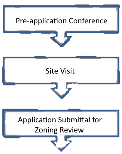
(Amd. of 4-15-2021)
19-8.1. - Conservation easement required.
All primary conservation areas and all secondary conservation areas shown on the rezoning application site plan and/or sketch plat that are required to be retained as open space, shall be permanently protected from further subdivision, development, and unauthorized use, by a conservation easement. A conservation easement, as defined by this Code, shall be approved by Forsyth County and 1) co-signed by Forsyth County and donated to a conservation organization or land trust; or 2) co-signed by Forsyth County and donated to a homeowners association; or 3) donated to Forsyth County if accepted by the County. Copies of the draft easements and delineation of primary and secondary conservation areas shall be submitted for review concurrent with the submittal of a land disturbance permit application.
(Amd. of 4-15-2021)
19-8.2. - Guidelines for drafting conservation easements.
The following guidelines are offered for drafting conservation easements and may be required:
(a)
The easement recognizes and describes in a statement of purpose the special qualities of the property subject to the easement. Preferably, conditions within the tract subject to the conservation easement are shown by map and/or photograph.
(b)
The easement clearly identifies the owner of the property subject to the easement, the holder of the easement, and co-signer, and the responsibilities of the property owner, easement holder, and co-signer.
(c)
The easement specifically and clearly identifies the boundaries of the property subject to the easement, preferably by metes and bounds legal description and survey plat.
(d)
The easement contains restrictions as to what the owner may do with the property and specifically delineate what may not be done with the property. Limitations may include but may not be confined to prohibitions against subdivision, earthmoving, dumping, signs, utility lines, construction, changes to existing structures, and uses made of the property.
(e)
The easement provides for the right of the easement holder and co-signer to inspect the property to assure observance of restrictions as well as provides for enforcement procedures.
(f)
The easement provides for the maintenance of property.
(g)
The easement contains provisions governing its amendment, including provisions that the easement shall not be altered except with the express written permission of the easement holder, property owner, and any co-signers.
(Amd. of 4-15-2021)
19-8.3. - Required ownership of open space.
In addition to a conservation easement, the open space shall be permanently protected through ownership either by a homeowners association or by Forsyth County, if accepted by the county, in accordance with this article.
(Amd. of 4-15-2021)
19-8.4. - Homeowners association.
If open space is owned and managed in common by a homeowners association, it shall be subject to the following requirements:
(a)
The developer of the conservation subdivision shall provide a description of the homeowners association, including bylaws and methods for maintaining open space, to the planning director for approval, prior to the approval of a final plat.
(b)
The homeowners association shall be established by the conservation subdivision developer and endowed with a financial subsidy from the developer prior to the approval of a final plat on the property involving a conservation subdivision.
(c)
Membership of each non-open space lot owner in the conservation subdivision shall be mandatory and automatic.
(d)
The homeowners association shall be responsible for maintenance, insurance, and taxes on the open space within the conservation subdivision. The association shall be required to assess dues for the maintenance of open space, purchase of insurance, and payment of taxes, unless another income source is proven to be available. Members of the association shall share equitably the costs of open space development and maintenance as indicated in bylaws. The association shall be empowered with the legal ability to place liens on non-open space lot owners for failure to pay association dues.
(e)
Said homeowners association shall not be dissolved without the consent of the board of commissioners. If common ownership of open space by a homeowners association is proposed and approved, then open space shall be subject to permanent deed and final plat restrictions or covenants on the future use, development, and subdivision of open space, in addition to the requirement of a conservation easement.
(f)
The board of commissioners may require that the homeowners association establish a minimum amount of funds to be initially deposited and maintained in a maintenance account.
(Amd. of 4-15-2021)
19-8.5. - Fee simple dedication to Forsyth County.
Dedication in fee-simple ownership to the public for recreational and/or open space use, is a possible mechanism for the permanent retention and maintenance of open space within the conservation subdivision, at the sole discretion of the board of commissioners, and subject to the following:
(a)
Dedication to the county shall only be approved if the board of commissioners finds that the size, shape, location, type of open space, or cost of development or maintenance of such open space or the availability of open space would make public ownership desirable or necessary.
(b)
The decision to accept open space for fee simple public ownership shall be at the sole discretion of the board of commissioners but guided by recommendations of the planning director, planning commission, the comprehensive plan as it pertains to open space acquisition, and the county parks and recreation director.
(c)
The board of commissioners generally will require dedication of all open space or park and recreation areas indicated for acquisition in the county's Comprehensive Plan or capital improvement program.
(d)
The board of commissioners may require a maintenance bond or other financial security with a duration of 12 months following public acceptance in an amount sufficient to ensure that such lands do not cause unwarranted public expenditures because of faulty conditions or construction. The board shall have authority to cash said bond in the event substandard conditions or construction are evident. Otherwise, following the one year period following public dedication, with satisfactory performance, the Board shall return the performance bond to the subdivider.
In addition to the required conservation easement, a deed for open space lands in a form acceptable to the county attorney in favor of Forsyth County shall be signed and recorded prior to the approval of any final plat pertaining to land within the conservation subdivision.
(Amd. of 4-15-2021)
19-9.1. - Evaluation criteria for approval.
In addition to the criteria listed in article V of chapter 8, evaluation criteria for a rezoning approval or sketch plat for a conservation subdivision shall be based on the extent to which the plan meets the following criteria:
(a)
All primary conservation areas are protected as permanent open space.
(b)
The required amount of secondary conservation areas are protected as permanent open space, and meet the requirements established within section 19-3.1, but also meet the over-all intent of conservation design.
(c)
The configuration of the secondary open space tract is contiguous and undivided.
(d)
The conservation subdivision meets applicable provisions of chapter 18, subdivisions of this Code, to the extent they are interpreted by the planning director to be applicable to a conservation subdivision.
(Amd. F of 5-12-2003; Amd. of 9-25-2003; Amd. of 2-2-2004; Amd. of 11-1-2007; Amd. of 4-15-2021)
19-9.2. - Grounds for denial.
In addition to the criteria listed in section 18-6.2 and article V of chapter 8 of this Code, grounds for denial of a rezoning and/or sketch plat application for a conservation subdivision shall include but are not limited to the following:
(a)
The application fails to fully identify primary and secondary conservation areas, or requirements pertaining to secondary conservation areas have not been met.
(b)
The proposed method of sewage treatment is inappropriate for the site or found to be potentially dangerous to public health.
(c)
One or more of the lots within the conservation subdivision are too small to meet the minimum lot size established by this chapter.
(d)
The street configuration does not provide for connectivity, or preserve natural features, or it is found to be inconsistent with the open space character of the subject property and its surroundings.
(e)
The proposed open space network is divided, not functional, inconsistent with open space plans of the county, or does not provide for the protection of the most valuable secondary conservation areas on the site given the natural and scenic properties inherent on the site, as substantiated by photographs or other documentation.
(f)
The proposed open space network fails to maximize the length of the common boundary between conservation areas on site and conservation areas or parkland abutting the conservation subdivision site.
(g)
The rezoning application and/or sketch plat appears to be submitted for the purpose of circumventing improvement requirements that would otherwise be required for conventional subdivisions pursuant to chapter 18 of this Code.
(h)
The design fails to incorporate standards and guidelines established herein, thus failing to comply with the intention of the chapter, and/or there is indication that the application was submitted for the purpose of increasing lot yield only.
(Amd. F of 5-12-2003; Amd. of 2-2-2004; Amd. of 11-1-2007; Amd. of 4-15-2021)