
Forsyth County Unincorporated
City Zoning Code
City Zoning Code
CHAPTER 20B
SPECIALTY DISTRICTS27
Editor's note— An amendment adopted November 4, 2021, amended chapter 20B in its entirety to read as herein set out. Former chapter 20B, §§ 20B-1.1, 20B-2.1—20B-2.4, 20B-3.1—20B-3.4, 20B-4.1, 20B-4.2, 20B-5.1, 20B-5.2, 20B-6.1—20B-6.3, pertained to master planned district, and derived from Amd. of 6-21-2004; Amd. of 11-15-2004; Amd. of 12-20-2004; Amd. of 12-1-2011; Amd. of 12-3-2015; Amd. of 9-7-2017; Amd. of 9-17-2018.
20B-1.1. - Purpose and intent.
The master planned district is intended to provide for mixed-use development. Uses must complement and be compatible with the orderly development of the project as well as surrounding land uses. The master planned district may be developed in distinct pods or can be integrated with a mix of uses being interspersed with one another, including multiple uses within the same structure. The density of residential development and intensity of nonresidential development should be consistent with the recommendations of the Forsyth County Comprehensive Plan.
The provisions of a master planned district are intended to establish a zoning district that will:
(A)
Provide a mechanism to incorporate and implement the goals and intent of the Forsyth County Comprehensive Plan in a manner that is not possible in conventional zoning classifications;
(B)
Allow for a mixture of complementary land uses based upon the existing and planned road networks in order to assure safe and efficient transportation patterns;
(C)
Provide for an orderly and creative arrangement of land uses in relation to each other and to the surrounding community;
(D)
Provide for the mobility of all inhabitants by walking, biking, or other means of transportation with diminished emphasis on the automobile;
(E)
Maintain mobility along traffic corridors and state highways;
(F)
Provide transitions between high traffic corridors and low density residential development;
(G)
Create a development of the highest architectural and aesthetic quality by demonstrating such standards via an approval process that is more rigorous than the requirements for rezoning to other zoning districts but no more onerous than is necessary to enable thorough analysis;
(H)
Minimize the environmental impacts of new development;
(I)
Promote the efficient use of land resulting in networks of utilities, streets, and other infrastructure features that maximize the allocation of fiscal and natural resources;
(J)
Stage development of this type in a manner which can be accommodated by the timely provision of public utilities, public facilities, public services, and public road improvements; and
(K)
Encourage the creation of new employment opportunities.
(Amd. of 11-4-2021)
20B-1.2. - Uses permitted.
(a)
General. Uses shall provide an orderly relation and function to other uses in the development and to existing land uses, as well as with due regard to the Comprehensive Plan of Forsyth County. Development within the district shall be limited to those uses specifically requested as part of the Master Development Handbook and approved by the board of commissioners, unless otherwise specifically noted in the approval of the master planned district.
(b)
Commercial and office uses. The amount of commercial and office land use within the master planned district shall be determined based on the amount of open space provided as shown in Table 20B.1. Land use calculations shall be calculated by gross floor area for master planned districts that contain a vertical mixture of uses and shall be calculated by total project land area for master planned districts that contain a horizontal mixture of uses.
(c)
Residential uses. The residential density within the master planned district shall be determined based on the maximum density as shown in Table 20B.1. Land use calculations shall be calculated by gross floor area for master planned districts that contain a vertical mixture of uses and shall be calculated by total project land area for master planned districts that contain a horizontal mixture of uses. For the residential allotment of units for the master planned district, the following maximums shall apply:
(1)
Thirty percent of total residential units for townhomes and/or condominiums.
(2)
Twenty percent of total residential units for apartments.
(d)
Open space. The master planned district shall require that open space be provided based on the percentage of commercial and office uses for the entire master plan district area, in accordance with Table 20B.1. For the purposes of this article, open space shall include areas within the master planned district designed and intended for the active and passive recreational needs of the residential and employment based population of the master planned district or for the public in general. Open space shall be owned by a homeowners association or similar body and shall not be part of individual residential lots. Table 20B-1 provides a summary of the percentage requirements
TABLE 20B.1
*Variances may not be requested for commercial and office use percentages for any MPD development located in the Haw Creek community node as depicted on the Forsyth County Comprehensive Plan's Community Character Map.
**Density allowance may be exceeded if section 20B-1.7, enhanced entitlements, is applicable.
(Amd. of 11-4-2021; Amd. of 12-1-2022; Amd. of 7-6-2023)
20B-1.3. - General conditions.
(a)
Code provisions. Whenever there is a conflict or difference between the provisions of this article and those of other chapters of the Unified Development Code, the provisions of this article shall prevail. Subjects not covered by this article shall be governed by the respective provisions found elsewhere in the Unified Development Code.
(b)
Water and sewer. Public water shall be required for all master planned districts. Public sewer or an existing private sewage treatment plant with sufficient capacity shall be required for all master planned districts.
(c)
Variance requests. Applications requesting rezoning to the master planned district must identify all variance requests in the rezoning application and represent such requests in the master development handbook. Variances shall be limited to the requirements of the Unified Development Code and shall follow the requirements of chapter 8 and as noted in this chapter.
(Amd. of 11-4-2021; Amd. of 12-1-2022)
20B-1.4. - Procedures.
(a)
Pre-application meeting. Before submitting an application for rezoning to master planned district, the applicant shall confer with the director to determine the feasibility for the proposed plan and its relationship to the Forsyth County Comprehensive Plan and the Unified Development Code.
(b)
Master development handbook. To enable a thorough analysis of an application for the master planned district, the application requirements exceed those of other zoning districts. In addition to the standard requirements, applications for the master planned district shall include a master development handbook. To avoid duplication, the information required for the master development handbook can be combined with the standard requirements to amend the official zoning map. The master development handbook shall include:
(1)
The uniform plan. A plan of the project showing the location of proposed zones and the general trajectories of the various thoroughfares. At a minimum, the Uniform Plan shall differentiate between the following zones:
(a)
Residential zones.
(b)
Shopping, business, or trade zones.
(c)
Civic and institutional zones.
(d)
Open space zones.
(e)
Vertical mixed use zones.
The applicant may develop more specific zones and or modify the name of the zones to better represent the theme of the proposed master planned district. An application is not required to include each of the zones listed above, see section 20B-1.2 for requirements related to permitted uses.
(2)
Land use standards. A matrix of text and or diagrams that regulate the permitted uses and performance standards for each zone identified in the uniform plan. Regulations of the Unified Development Code that are not listed in the land use standards shall default to the standards identified in other chapters, which will be determined by the director in any case in which applying the regulations of other chapters would be unclear. At a minimum, the following shall be established for each zone identified in the uniform plan:
(a)
Permitted uses.
(b)
Minimum lot size.
(c)
Minimum lot width.
(d)
Minimum setbacks.
(e)
Minimum building separation.
(f)
Buffers and impervious surface setbacks.*
(g)
Maximum height.
(h)
Maximum building coverage.
(i)
Parking and loading requirements.
*Riparian buffers and impervious surface setbacks as set forth in UDC 18-11.2 shall not be modified except via the process in UDC 18-11.3.
(3)
Community standards. The community standards are intended to produce visual compatibility among various building types and, at a minimum, the community standards shall address lighting, signage, fences, landscaping, building materials, building colors, and other architectural features. The following shall be submitted to address each of the community standards:
(a)
Lighting. A pedestrian scale lighting illustration that demonstrates the relationship of the pedestrian to street light features and types and styles of light fixtures that will be used.
(b)
Signage. Signage plan pertaining to non-residential uses for any proposed sign types. All proposed signage in the signage plan shall conform to the dimensional and numerical requirements of the Forsyth County Sign Ordinance.
(c)
Fences. Fence and wall details for community, residential spaces and non-residential uses that demonstrate a cohesion in material and maintain a relationship with the character of the surrounding land uses and structures.
(d)
Landscaping. A landscape plan that incorporates planting materials to enhance the existing area, particularly as viewed from an adjacent right-of-way, and to mitigate development impacts.
(e)
Building materials. Building elevations and details pertaining to wall finishes with indication of the wall cladding material.
(f)
Building colors. Building elevations or renderings demonstrating the permissible colors for materials on walls, roofs, and any accent feature.
(g)
Architectural features. Details pertaining to elements found in the built environment that create community character and visual interest.
(4)
Additional requirements. Text, drawings, and/or diagrams providing the following information:
(a)
A construction phasing schedule for phased projects that shall comply with the following criteria:
(i)
The developer is required to obtain a certificate of occupancy for a significant component of the non-residential uses prior to completing development of any residential element.
(ii)
Upon completion of the initial phased development, the proposed future phases shall remain as accessible open space areas, provided the land is undisturbed and not hazardous to the health, safety, and welfare of residents and the public, until such time that the proposed portion will be constructed.
(b)
Method of water and sewer service, including verification of capacity;
(c)
A summary of the anticipated maintenance and ownership of streets and open spaces;
(d)
Proposed amount and general location of open space;
(e)
Proposed maximum number of residential dwelling units by type and minimum lot size. Examples include, but are not limited to: single family detached, single family attached, townhomes, and apartments. Information on lot size shall be classified by the following:
(i)
Lots over 18,000 square feet.
(ii)
Lots 12,000 to 18,000 square feet.
(iii)
Lots 6,000 to 11,999 square feet.
(iv)
Lots under 6,000 square feet.
(v)
Any unit not located on a individual lot.
(f)
Proposed maximum gross floor area devoted to non-residential uses;
(g)
Typical information on landscape features in relation to streets, parking areas, sidewalks, building footprints, and utilities;
(h)
A plan identifying the existing tree canopy. Information available from the County's GIS data is acceptable for the rezoning stage;
(i)
Existing topography with contour intervals no greater than four feet. Information available from the county's GIS data is acceptable for the rezoning stage;
(j)
State waters, wetlands, and floodplains. Information available from the county's GIS data is acceptable for the rezoning stage; and
(k)
A summary of issues related to connectivity. The information should include available information on private and public streets; significant vehicular parking and loading areas; the provision of bicycle parking areas, paths, sidewalks, and other similar features; and interconnections to adjoining property.
(l)
MPD developments located in the Haw Creek community node as depicted on the Forsyth County Comprehensive Plan's Community Character Map shall not be bisected or otherwise divided by any existing, public roads.
(m)
The design of all building façades, including exterior finish materials, architectural elements and other details necessary to clarify exterior features.
(Amd. of 11-4-2021; Amd. of 12-1-2022; Amd. of 5-4-2023; Amd. of 11-4-2023)
20B-1.5. - Criteria for approval.
(a)
Standard criteria. In considering and acting upon applications for rezoning to the master planned district, the planning commission and the board of commissioners shall consider and base their recommendation and decision, respectively, on the general considerations and special considerations described in chapter 8, article V of this Code; provided, however, that the planning commission and board of commissioners will additionally consider the extent to which the proposal follows the recommendations and requirements of this article.
(b)
Design criteria. In addition to the standard criteria, the following design criteria will be used to evaluate the rezoning application's conformity with the purpose and intent of this article. Appropriate criteria that have not been incorporated into the master development handbook will be utilized to develop recommended zoning conditions as part of the review process.
(1)
General site design.
(a)
The minimum size for a master planned district should not be less than 40 acres. MPD developments located in the Haw Creek community node as depicted on the Forsyth County Comprehensive Plan's Community Character Map shall not be less than 50 acres.
(b)
A functional town center, community green, park, or other focal point should be included to create character and identity.
(c)
Perimeter setbacks and buffers should protect the privacy of existing and anticipated uses that adjoin the subject property.
(d)
A minimum undisturbed buffer of 40 feet and setback of 50 feet shall be provided along an exterior property line abutting a residential, OR, A1 or AG-Res district.
(e)
The master planned district should incorporate multi-modal transportation elements in the development, depending on the foreseeable needs of future residents and users of the site, and the relationship of the project site to the community at large. Such multi-modal elements may include provisions for public transport, carpooling lots, ridesharing service locations, pedestrian and bicycle paths and lanes, bicycle parking areas, and other similar provisions.
(f)
A grid system of streets is preferred over cul-de-sac designs. Block length should be conducive to pedestrian traffic.
(g)
Interconnections to adjoining property, whether developed or undeveloped, should be included and incorporated into the design where appropriate. Proposed parcels should be arranged and designed so as to allow for the opening of future streets and provide access to those areas not presently served by streets.
(2)
Aesthetic quality.
(a)
When appropriate, streets should terminate at a focal point, which may be a civic building, principal use, place of worship, active community space, bell tower, gazebo, or other similar feature.
(b)
The location and width of residential garage doors, if present, shall be designed so as to not dominate the streetscape. Standards on garage width and garage setbacks should be used to ensure that garage doors do not dominate the streetscape.
(c)
Attached housing, if present, should be designed to reduce the monolithic nature of the structure.
(d)
Fences, walls, and berms should be designed and maintained in relationship with the character of the surrounding land uses and structures. Retaining walls should be constructed of architectural masonry or faced with rock, brick, and/or constructed to blend with adjacent surroundings.
(e)
Detention and retention structures are discouraged in areas subject to view from a public street if not used both for aesthetic purposes and designed so as to not require a fenced enclosure.
(f)
Master planned districts are encouraged to utilize creative methods for stormwater management, when such methods provide additional open space opportunities.
(g)
Service and loading zones should be located to minimize visibility from public streets and neighboring properties.
(3)
Site development.
(a)
Transitions at property edges should seem natural for the surrounding terrain.
(4)
Parking.
(a)
Decorative fences or walls, plantings, berms, or other similar features should be used to screen surface parking lots from public view or soften their visual impact.
(b)
The location and design of parking structures should minimize their visibility from the street or other public areas.
(c)
Surface parking lots should be oriented behind or to the side of a building when possible. Surface parking lots should not be located on street corners.
(d)
The architectural features of a parking deck or structure shall be constructed of similar materials, colors, and detailing to match those used on the rest of the principal structure(s).
(5)
Pedestrian scale.
(a)
For predominantly areas, activities such as shops, offices or other commercial space should be located along the ground level of street frontage.
(b)
For nonresidential uses, corner buildings should make a strong tie to the building lines of each street. However, this does not preclude angled or sculpted building corners or an open plaza at the corner. Vertical focal points to visually "anchor" corners are encouraged.
(c)
Comfortable and attractive street furniture should be provided in public spaces for public enjoyment, comfort, and convenience. These may include seats and benches, drinking fountains, trash receptacles, information kiosks, directories, or other similar features.
(d)
Nonresidential building entrances should be visible from the street, well-lit, and easily accessible. Articulation such as canopies and roof forms should be used to further identify entrances.
(e)
Nonresidential uses that face a street or pedestrian area shall have transparent windows along each first floor wall.
(f)
Nonresidential buildings should have at least one entrance facing every abutting street.
(g)
Clear pedestrian and visual paths shall be established using a combination of covered arcades, covered walkways, courtyards, landscape patterns, consistent paving materials, minimal interruption of pedestrian paths, and other similar features.
(h)
Sidewalks should be present in all residential areas. In nonresidential areas, sidewalks should be present along both sides of all streets.
(i)
All streets, pedestrian paths and trails within the master planned district shall remain ungated for public access.
(6)
Landscape and natural environment.
(a)
Specific emphasis should be placed on the preservation or planting of trees between buildings and the street.
(b)
Existing topography, significant tree cover, state waters and other natural features should be considered and incorporated into the project design whenever possible.
(c)
Required open space should be distributed throughout the project.
(d)
Landscaping shall provide buffering between non-compatible land uses.
(e)
Removal of vegetation as identified on the United States Department of Agriculture Georgia List of Exotic and Invasive Plants is permitted provided such removal is minimal and does not occur within undisturbed state and county stream buffers.
(7)
Built environment.
(a)
The height of any structure should be compatible with the existing buildings in the area, and proposed structures within the project site.
(b)
Limitations on the height, size, and type of exterior signage shall produce an overall theme that is compatible with proposed buildings and surrounding property.
(c)
The primary entrance and front facade of individual buildings within a development may be oriented toward streets, private drives or open space, and should not be oriented toward off-street parking lots, garages, or carports.
(Amd. of 11-4-2021; Amd. of 12-1-2022; Amd. of 11-2-2023)
20B-1.6. - Amendments.
(a)
Conformance to approved master development handbook. All further development of the property shall conform to the approved master development handbook, regardless of any change in ownership, unless the county approves minor or major amendments.
(b)
Minor amendments. The director may approve minor amendments to the approved master development handbook, which are in compliance with the provisions and intent of this article, and do not depart from the principal concept of the approved master development handbook. Minor amendments are those determined by the director of the department to meet the purpose and intent of the master planned district, which would not affect adjacent properties. Minor amendments shall be approved as part of the land disturbance permitting process. The director of the department may require the applicant to provide written justification for the minor amendment if such justification is not evident within the land disturbance permit itself.
(c)
Major amendments. Should the director determine that a requested change or deviation from the approved master development handbook departs from the principles of the master development handbook and would affect adjacent properties, the proposed modification will be classified as a major amendment. The applicant may apply for approval of a major amendment to the board of commissioners as an application for modification of conditions of zoning, as established in chapter 8, article IX of this Code.
(Amd. of 11-4-2021)
20B-1.7. - Enhanced entitlements.
(a)
Applicability. Notwithstanding any provisions in sections 20B-1.1 through 20B-1.6 to the contrary, for master planned district developments of no less than 130 acres that were zoned to the master planned development district in or before 2015, that include a contiguous parcel of 0.684 acres that was zoned to the Master Planned District in 2024, and where said development is approved for 690 residential units and between 250,000 to 550,000 square feet of commercial space, such developments shall be entitled to the following additional land use entitlements upon fulfillment of the conditions set forth in this section.
(1)
Entitlements and conditions.
a.
An additional 265 multi-family dwelling units, subject to the following requirements including those conditions in section 20B-1.7(a)(1)b.—d.
(i)
Construction of the multi-family dwelling units shall only occur upon the retail establishment identified in section 20B-1.7(a)(1)b. commencing vertical construction at the location identified in section 20B-1.7(b);
(ii)
No certificate of occupancy shall be issued for any of the multi-family dwelling units until the retail establishment identified in section 20B-1.7(a)(1)b. is issued its certificate of occupancy;
(iii)
At least ten multi-family dwelling units shall be provided for rent to county first responders at a 50 percent discount from the then-current rental rate of an equivalent unit; and
(iv)
The multi-family dwelling units shall be developed by the entity identified as the applicant on rezoning application ZA3728, dated February 6, 2015.
b.
Development shall contain a high-end retail grocery.
c.
Development shall have a commercial off-leash dog park.
d.
Development shall remain activated, meaning that the developer shall program the development open spaces with a minimum of two public events per week.
(2)
No additional multi-family. Other than the conditional multi-family authorized by section 20B-1.7(a)(1)a., no additional multi-family shall be authorized for any development satisfying the applicability criteria in section 20B-1.7(a).
(b)
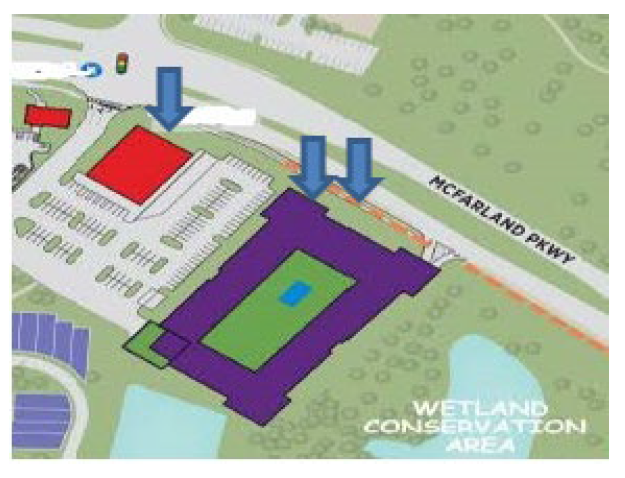
Layout of additional entitlements. The additional residential entitlements in section 20B-1.7(a)(1)a. shall be constructed in the general proximity of the double arrows and the high-end retail grocer required by section 20B-1.7(a)(1)b. shall be constructed in the general proximity of the single arrow in the depiction immediately below:
(c)
Sketch plat required. Notwithstanding any other provision of section 20B-1.7, prior to applying for permits for the enhanced entitlements, the developer shall be required to apply for and receive sketch plat approval under UDC section 8-5.1.
(Amd. of 7-6-2023; Amd. of 3-7-2024)
20B-2.1. - Purpose and intent.
The mixed-use center district is intended to provide for a complementary mix of commercial, office, residential, and light industrial uses, but may strictly focus upon an assemblage of non-residential uses as well. Compact development is encouraged to promote economic development, alternative transportation, green infrastructure and close proximity to employment and consumer activities.
The provisions of a mixed-use center district are intended to establish a zoning district that will:
(a)
Permit flexible and compatible arrangements of land uses;
(b)
Provide locations for the development of cultural, recreational, educational and health service facilities;
(c)
Promote compatible development, in size and scale, to surrounding residential subdivisions;
(d)
Encourage campus style developments;
(e)
Advance pedestrian oriented, compact design;
(f)
Plan for connectivity of streets and elevate opportunities for alternative modes of travel.
(Amd. of 11-4-2021)
20B-2.2. - Uses permitted.
(a)
General. Uses shall provide an orderly relation and function to other uses in the development and to existing land uses. Adherence to the Forsyth County Comprehensive Plan in regards to recommended uses and development intensity shall be required. Development within the district shall be limited to those uses specifically requested as part of the master development handbook and approved by the board of commissioners, unless otherwise specifically noted in the approval of the mixed-use center district.
(b)
Uses permitted. The mixed-use center district may propose a mix of commercial, office, residential, and light industrial uses or a range of non-residential uses. If a proposal includes residential, this use shall not be predominate within the development.
(c)
Residential density. The maximum residential density for the mixed-use center district shall be six units per acre, if applicable. The maximum residential density may be increased above six units per acre based on the application of incentives pursuant to section 20B-2.4, if applicable.
(d)
Open space. The mixed-use center district shall have a minimum open space requirement of 20 percent of the total site acreage.
(Amd. of 11-4-2021)
20B-2.3. - Design criteria.
The following design criteria will be used to evaluate conformity with the purpose and intent of this article. Design elements that are not required, but encouraged, may be utilized to develop recommended zoning conditions as part of the review process if they are omitted from the master development handbook.
(a)
General site design.
(1)
The minimum size for a mixed-use center district shall not be less than 30 acres.
(2)
A functional town center, community green, park, or other focal point shall be included to create character and identity.
(3)
Perimeter setbacks and buffers shall protect the privacy of existing and anticipated uses that adjoin the subject property.
(4)
For a mixed-use or non-residential mixed-use center district, a minimum undisturbed buffer of 40 feet and setback of 50 feet shall be provided along an exterior property line abutting a residential, OR, A1 or AG-Res district. For a residential mixed-use center district, a minimum undisturbed buffer of 25 feet and setback of 50 feet shall be provided along an exterior property line abutting a residential, OR, A1 or AG-Res district.
(5)
The mixed-use center district should incorporate multi-modal transportation elements in the development, depending on the foreseeable needs of future residents and users of the site, and the relationship of the project site to the community at large. Such multi-modal elements may include provisions for public transport, carpooling lots, ridesharing service locations, pedestrian and bicycle paths and lanes, bicycle parking areas, and other similar provisions.
(6)
A grid system of streets is preferred over cul-de-sac designs. Block length should be conducive to pedestrian traffic.
(7)
Interconnections to adjoining property, whether developed or undeveloped, shall be included and incorporated into the design where appropriate. Proposed parcels should be arranged and designed so as to allow for the opening of future streets and provide access to those areas not presently served by streets.
(b)
Open space. Open space within the context of the mixed-use center district shall be independent of regulations found in other parts of this Code. Open space for the mixed-use center district is intended to create active community spaces and preserve undisturbed land areas. Open space shall meet the minimum standards found in sections 20B-3.2, 20B-3.3, and shall incorporate the use of active community spaces as defined in Table 20B.2. Notwithstanding anything to the contrary herein, no property that is approved for MCD use pursuant to this article shall be eligible for impact fee credits for parks.
(1)
General requirements.
(a)
Easements for utilities shall not count toward the required open space.
(b)
Structural stormwater control practices shall not count toward the required open space.
(2)
Active community spaces. Active community spaces shall be designed for recreational or leisure purposes and may be constructed of pervious and non-pervious materials. Active community spaces shall comply with the following criteria:
(a)
A minimum of 25 percent of the total open space requirements as identified in section 20B-3.2 shall be an active community space.
(b)
Active community space shall be publicly accessible during daylight hours and shall be directly accessible from a public sidewalk as illustrated in Table 20B.2.
(c)
Active community spaces shall provide landscaped areas, which must include a combination of trees, shrubs, herbaceous ornamentals, and vegetative ground cover including grasses.
(d)
Trees used to satisfy minimum active community space requirements shall:
(i)
Be at least three and one-half inches in caliper size;
(ii)
Reach a mature height of 40 feet; and
(iii)
Be spaced a minimum 25 feet on-center.
(3)
Undisturbed land areas. Undisturbed land areas shall create open space that conserves natural resources not counting areas otherwise required to be preserved by federal, state or local regulations. Undisturbed land areas shall comply with the following criteria:
(a)
A minimum of 25 percent of the total open space requirements as identified in section 20B-3.2 shall be an undisturbed land area.
(b)
Undisturbed land areas used to satisfy the requirements of this Article shall be preserved in a natural state except for the removal of litter and dead, diseased or hazardous trees as approved by a registered forester or certified arborist.
(4)
When a commercial or industrial building as well a residential amenity building adjoins open space, pedestrian access (both ingress and egress) shall be provided.
(5)
Covenants or other legal arrangements shall specify ownership of all open spaces, the method of and responsibility for maintenance, taxes and insurance, compulsory membership and assessment provisions, and shall be incorporated into legal instruments sufficient to ensure that the open space requirements of this article are maintained.
TABLE 20B.2 ACTIVE COMMUNITY SPACE PERFORMANCE STANDARDS
| Active Community Space Type | Example Illustration | General Description | Design Requirements |
|---|---|---|---|
| Playground | 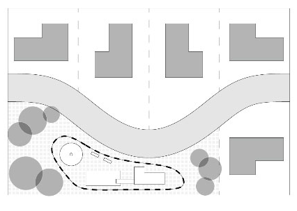 | A Playground provides space for supervised recreation for children within a neighborhood, or as part of a larger neighborhood or community park. |
• Shall be designed with commercial grade play equipment
• Minimum area of 2,000 square feet with no maximum requirement |
| Square | 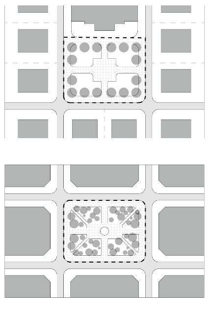 | A Square provides a means to emphasize important places, intersections, or centers. |
• Shall be bound by streets on a minimum of three sides or 75 percent
• May be bound by front facing lots on one side or 25 percent of their perimeter • No rear facing lots allowed adjacent to a square • Tree planting is encouraged parallel to the street right-of-way • Minimum area of 2,000 square feet up to a maximum area of two acres |
| Plaza | 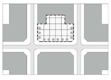 | A Plaza is an outdoor area for community leisure that is entirely bounded by streets, lanes, or buildings. |
• Shall maintain an orthogonal shape that is parallel to a bounded street, lane, or
building
• Shall be level, stepped or gently sloping • Minimum area of 4,000 square feet up to a maximum area of one acre |
| Community Park | 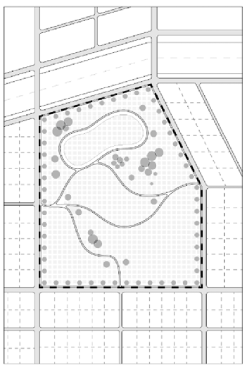 | Community Parks are designed for active and passive recreational use. Community Parks create a central open space that services an entire neighborhood or group of neighborhoods, or incorporates physical features that are an asset to the community. |
• Trees shall be planted at the edge of community park boundaries
• Shall be bounded by streets on a minimum of 50 percent of their perimeter • Minimum area of 20,000 square feet with no maximum requirement |
(c)
Aesthetic quality.
(1)
When appropriate, streets should terminate at a focal point, which may be a civic building, principal use, place of worship, active community space, bell tower, gazebo, or other similar feature.
(2)
The location and width of residential garage doors, if present, shall be designed so as to not dominate the streetscape. Standards on garage width and garage setbacks should be used to ensure that garage doors do not dominate the streetscape.
(3)
Attached housing, if present, shall be designed to reduce the monolithic nature of the structure.
(4)
Fences, walls, and berms should be designed and maintained in relationship with the character of the surrounding land uses and structures. Retaining walls should be constructed of architectural masonry or faced with rock, brick, and/or constructed to blend with adjacent surroundings.
(5)
Detention and retention structures are discouraged in areas subject to view from a public street if not used both for aesthetic purposes and designed so as to not require a fenced enclosure.
(6)
Mixed-Use Center Districts are encouraged to utilize creative methods for stormwater management, when such methods provide additional open space opportunities.
(7)
Service and loading zones shall be located to minimize visibility from public streets and neighboring properties.
(d)
Site development.
(1)
Transitions at property edges should seem natural for the surrounding terrain.
(e)
Parking.
(1)
Decorative fences or walls, plantings, berms, or other similar features shall be used to screen surface parking lots from public view or soften their visual impact.
(2)
The location and design of parking structures should minimize their visibility from the street or other public areas.
(3)
Surface parking lots should be oriented behind or to the side of a building when possible. Surface parking lots should not be located on street corners.
(4)
The architectural features of a parking deck or structure shall be constructed of similar materials, colors, and detailing to match those used on the rest of the principal structure(s).
(f)
Pedestrian scale.
(1)
For predominantly nonresidential areas, activities such as shops, offices or other commercial space should be located along the ground level of street frontage.
(2)
For nonresidential uses, corner buildings should make a strong tie to the building lines of each street. However, this does not preclude angled or sculpted building corners or an open plaza at the corner. Vertical focal points to visually "anchor" corners are encouraged.
(3)
Comfortable and attractive street furniture shall be provided in public spaces for public enjoyment, comfort, and convenience. These may include seats and benches, drinking fountains, trash receptacles, information kiosks, directories, or other similar features.
(4)
Nonresidential building entrances shall be visible from the street, well-lit, and easily accessible. Articulation such as canopies and roof forms should be used to further identify entrances.
(5)
Nonresidential uses that face a street or pedestrian area shall have transparent windows along each first floor wall.
(6)
Nonresidential buildings shall have at least one entrance facing every abutting street.
(7)
Clear pedestrian and visual paths shall be established using a combination of covered arcades, covered walkways, courtyards, landscape patterns, consistent paving materials, minimal interruption of pedestrian paths, and other similar features.
(8)
Sidewalks shall be present in all residential areas. In nonresidential areas, sidewalks should be present along both sides of all streets.
(9)
All streets, pedestrian paths and trails within the Mixed-Use Center District shall remain ungated for public access.
(g)
Landscape and natural environment.
(1)
Specific emphasis should be placed on the preservation or planting of trees between buildings and the street.
(2)
Existing topography, significant tree cover, state waters and other natural features should be considered and incorporated into the project design whenever possible.
(3)
Required open space should be distributed throughout the project.
(4)
Landscaping shall provide buffering between non-compatible land uses.
(h)
Built environment.
(1)
The height of any structure shall be compatible with the existing buildings in the area, and proposed structures within the project site.
(2)
Limitations on the height, size, and type of exterior signage shall produce an overall theme that is compatible with proposed buildings and surrounding property.
(3)
The primary entrance and front façade of individual buildings within a development may be oriented toward streets, private drives or open space, and should not be oriented toward off-street parking lots, garages, or carports.
(Amd. of 11-4-2021; Amd. of 11-2-2023)
20B-2.4. - Incentives.
The mixed-use center district offers an incentive to developers to increase their allowable residential density through the redevelopment of properties with deteriorated conditions.
(a)
Redevelopment. The mixed-use center district encourages developers to redevelop properties through a residential density bonus up to two residential units per acre on areas identified as deteriorated per the criteria listed below.
(1)
All deteriorated areas within properties shall be identified by the applicant and approved by staff.
(2)
Shall redevelop 100 percent of the deteriorated conditions acreage found on the development site to qualify for the density incentive.
(3)
Deteriorated conditions shall be determined as follows:
(a)
Uninhabitable, unsafe, or abandoned structure(s);
(b)
Structures that are substantively declining in value or usefulness due to observable neglect;
(c)
A site or portion of a site identified by the Federal Environmental Protection Agency as having environmental contamination to an extent that requires remedial investigation or a feasibility study;
(d)
Is in a state or condition that attracts rodents, mosquitoes, or other disease-transmitting animals;
(e)
Is in a state or condition that attracts or propagates criminal activity on the property or adjacent properties.
(4)
The applicant shall provide the following documents, prepared by a professional architect, engineer, surveyor, landscape architect, and or land planner:
(a)
An inspection report of the property containing written and photo documented evidence of the existing, deteriorated conditions onsite;
(b)
A scaled map identifying where deteriorated conditions exist on the property and the affected acreage on the development site;
(c)
A scaled plan and strategy for redevelopment and any rehabilitation of the existing conditions that ensures the safety and welfare of future inhabitants and remediates any environmental impacts.
(Amd. of 11-4-2021)
20B-2.5. - General conditions.
(a)
Code provisions. Whenever there is a conflict or difference between the provisions of this article and those of other chapters of the Unified Development Code, the provisions of this article shall prevail. Subjects not covered by this article shall be governed by the respective provisions found elsewhere in the Unified Development Code.
(b)
Water and sewer. Public water with sufficient flow volume and pressure to meet water supply and fire flow needs shall be required for all mixed-use center districts. Public sewer or an existing private sewage treatment plant with sufficient treatment and collection system capacity shall be required for all mixed-use center districts.
(c)
Variance requests. Applications requesting rezoning to the mixed-use center district must identify all variance requests in the rezoning application and represent such requests in the master development handbook. Variances shall be limited to the requirements of the Unified Development Code and shall follow the requirements of chapter 8.
(Amd. of 11-4-2021)
20B-2.6. - Procedures.
(a)
Pre-application meeting. Before submitting an application for rezoning to mixed-use center district, the applicant shall schedule a pre-application meeting with planning staff and the district commissioner to determine the feasibility for the proposed plan and its relationship to the Forsyth County Comprehensive Plan and the Unified Development Code. The application can only advance to the planning commission with the support of the district commissioner.
(b)
Master development handbook. To enable a thorough analysis of an application for the mixed-use center district, the application requirements exceed those of other zoning districts. In addition to the standard requirements, applications for the mixed-use center district shall include a master development handbook. The handbook shall illustrate design criteria per section 20B-3.3 in addition to proposed land use standards listed below. To avoid duplication, the information required for the master development handbook can be combined with the standard requirements to amend the official zoning map. The master development handbook shall include:
(1)
The uniform plan. A plan of the project showing the location of proposed zones and the general trajectories of the various thoroughfares. At a minimum, the Uniform Plan shall differentiate between the following zones:
(a)
Vertical mixed use zones.
(b)
Residential zones with separate designations for varying housing types.
(c)
Commercial, office, or industrial zones.
(d)
Civic and institutional zones.
(e)
Open space zones with active community spaces identified.
The applicant may develop more specific zones and or modify the name of the zones to better represent the theme of the proposed mixed-use center district. An application is not required to include each of the zones listed above, see section 20B-3.2 for requirements related to permitted uses.
(2)
Land use standards. A matrix of text and or diagrams that regulate the permitted uses and performance standards for each zone identified in the uniform plan. Regulations of the Unified Development Code that are not listed in the land use standards shall default to the standards identified in other chapters, which will be determined by the director in any case in which applying the regulations of other chapters would be unclear. At a minimum, the following land use standards shall be established for each zone identified in the uniform plan:
(a)
Permitted uses.
(b)
Minimum lot size.
(c)
Minimum lot width.
(d)
Minimum setbacks.
(e)
Minimum building separation.
(f)
Buffers and impervious surface setbacks.*
(g)
Maximum height.
(h)
Maximum building coverage.
(i)
Parking and loading requirements.
*Riparian buffers and impervious surface setbacks as set forth in UDC 18-11.2 shall not be modified except via the process in UDC 18-11.3.
(3)
Community standards. The community standards are intended to produce visual compatibility among various building types and, at a minimum, the community standards shall address lighting, signage, fences, landscaping, building materials, building colors, and other architectural features. The following shall be submitted to address each of the community standards:
(a)
Lighting. A pedestrian scale lighting illustration that demonstrates the relationship of the pedestrian to street light features and types and styles of light fixtures that will be used.
(b)
Signage. Signage plan pertaining to non-residential use for any proposed sign types. All proposed signage in the signage plan shall conform to the dimensional and numerical requirements of the Forsyth County Sign Ordinance.
(c)
Fences. Fence and wall details for community, residential spaces and non-residential uses that demonstrate a cohesion in material and maintain a relationship with the character of the surrounding land uses and structures.
(d)
Landscaping. A landscape plan that incorporates planting materials to enhance the existing area, particularly as viewed from an adjacent right-of-way, and to mitigate development impacts.
(e)
Building materials. Building elevations and details pertaining to wall finishes with indication of the wall cladding material.
(f)
Building colors. Building elevations or renderings demonstrating the permissible colors for materials on walls, roofs, and any accent feature.
(g)
Architectural features. Details pertaining to elements found in the built environment that create community character and visual interest.
(4)
Phasing standards. The phasing standards shall consist of a construction phasing schedule and plan for phased projects. Phased projects shall comply with the following criteria:
(a)
For a mixed-use center district development, the developer is required to obtain a certificate of occupancy for a significant component of the non-residential uses prior to completing development of any residential element, if present.
(b)
For all mixed-use center district developments, upon completion of the initial phased development, the proposed future phases shall remain as accessible open space areas, provided the land is undisturbed and not hazardous to the health, safety, and welfare of residents and the public, until such time that the proposed portion will be constructed.
(5)
Additional requirements. Text and or diagrams providing the following information:
(a)
Method of water and sewer service, including verification of capacity;
(b)
A summary of the anticipated maintenance and ownership of streets and open spaces;
(c)
Proposed maximum number of residential dwelling units by type and minimum lot size, if applicable;
(d)
Proposed maximum gross floor area devoted to non-residential uses;
(e)
A plan identifying the existing tree canopy. Information available from the County's GIS data is acceptable for the rezoning stage;
(f)
Existing topography with contour intervals no greater than four feet. Information available from the county's GIS data is acceptable for the rezoning stage;
(g)
State waters, wetlands, and floodplains. Information available from the county's GIS data is acceptable for the rezoning stage; and
(h)
A summary of issues related to connectivity. The information should include available information on private and public streets; significant vehicular parking and loading areas; the provision of bicycle parking areas, paths, sidewalks, and other similar features; and interconnections to adjoining property.
(i)
The design of all building façades, including exterior finish materials, architectural elements, and other details necessary to clarify exterior features.
(Amd. of 11-4-2021; Amd. of 5-4-2023; Amd. of 11-2-23)
20B-2.7. - Amendments.
(a)
Conformance to approved master development handbook. All further development of the property shall conform to the approved master development handbook, regardless of any change in ownership, unless the county approves minor or major amendments.
(b)
Minor amendments. The director may approve minor amendments to the approved master development handbook, which are in compliance with the provisions and intent of this article, and do not depart from the principal concept of the approved master development handbook. Minor amendments are those determined by the director to meet the purpose and intent of the mixed-use center district, which would not affect adjacent properties. Minor amendments shall be approved as part of the land disturbance permitting process. The director may require the applicant to provide written justification for the minor amendment if such justification is not evident within the land disturbance permit itself.
(c)
Major amendments. Should the director determine that a requested change or deviation from the approved master development handbook departs from the principles of the master development handbook and would affect adjacent properties, the proposed modification will be classified as a major amendment. The applicant may apply for approval of a major amendment to the board of commissioners as an application for modification of conditions of zoning, as established in chapter 8, article IX of this Code.
(Amd. of 11-4-2021)
20B-3.1. - Purpose and intent.
The mixed residential district is intended to provide for residential development, which may contain a variety of housing types to accommodate diverse housing preferences. The mixed residential district encourages creative, residential planning and development within the county that will preserve unique environmental features and be consistent with the Forsyth County Comprehensive Plan.
The provisions of a mixed residential district are intended to establish a zoning district that will:
(a)
Provide a variety of housing options that may include single-family detached, single-family attached and multi-family housing products;
(b)
Offer flexibility in design and product types while protecting the integrity and quality of surrounding neighborhoods;
(c)
Maintain harmony of scale, intensity, and design across varying housing options;
(d)
Encourage a sense of community through design that promotes a sense of place through quality craftsmanship;
(e)
Promote the health and well-being of residents through the development of pedestrian and bicycle accommodations;
(f)
Create a development of high architectural and aesthetic quality by demonstrating such standards via an approval process that is more rigorous than the requirements for rezoning to other zoning districts, but is no more onerous than is necessary to enable a thorough analysis.
(Amd. of 10-20-2022)
20B-3.2. - Uses permitted.
(a)
General. Uses shall provide an orderly relation and function to other uses in the development and to existing land uses. Adherence to the Forsyth County Comprehensive Plan in regard to recommended uses shall be required. Development within the district shall be limited to those uses specifically requested as part of the Master Development Handbook and approved by the board of commissioners, unless otherwise specifically noted in the approval of the mixed residential district.
(b)
Uses permitted. The mixed residential district encompasses an exclusively residential development, which may contain a variety of housing types.
(c)
Residential density. The maximum residential density for the mixed residential district shall be six units per acre.
(d)
Open space. The mixed residential district shall have a minimum open space requirement of twenty (20) percent of the total site acreage.
(Amd. of 10-20-2022)
20B-3.3. - Design criteria.
The following design criteria will be used to evaluate conformity with the purpose and intent of this article. Design elements that are not required, but encouraged, may be utilized to develop recommended zoning conditions as part of the review process if they are omitted from the Master Development Handbook.
(a)
General site design.
(1)
The minimum size for a mixed residential district shall not be less than 30 acres.
(2)
A functional town center, community green, park, or other focal point shall be included to create character and identity.
(3)
Perimeter setbacks and buffers shall protect the privacy of existing and anticipated uses that adjoin the subject property.
(4)
A minimum undisturbed buffer of 25 feet and setback of 50 feet shall be provided along an exterior property line abutting a residential, OR, A1 or AG-Res district.
(5)
The mixed residential district should incorporate multi-modal transportation elements in the development, depending on the foreseeable needs of future residents and users of the site, and the relationship of the project site to the community at large. Such multi-modal elements may include provisions for public transport, carpooling lots, ridesharing service locations, pedestrian and bicycle paths and lanes, bicycle parking areas, and other similar provisions.
(6)
Interconnections to adjoining property, whether developed or undeveloped, shall be included and incorporated into the design where appropriate. Proposed parcels should be arranged and designed so as to allow for the opening of future streets and provide access to those areas not presently served by streets.
(b)
Open space. Open space within the context of the mixed residential district shall be independent of regulations found in other parts of this Code. Open space for the mixed residential district is intended to create active community spaces and preserve undisturbed land areas. Open space shall meet the minimum standards found in 20B-3.2, 20B-3.3, and shall incorporate the use of active community spaces as defined in Table 20B.3. Notwithstanding anything to the contrary herein, no property that is approved for MRD use pursuant to this article shall be eligible for impact fee credits for parks.
(1)
General requirements.
(a)
Easements for utilities shall not count toward the required open space.
(b)
Structural stormwater control practices shall not count toward the required open space.
(c)
Requirements pertaining to low-impact stormwater design within Chapter 18, Article 13 shall not apply.
(2)
Active community spaces. Active community spaces shall be designed for recreational or leisure purposes and may be constructed of pervious and non-pervious materials. Active community spaces shall comply with the following criteria:
(a)
A minimum of 25 percent of the total open space requirements as identified in section 20B-3.2 shall be an active community space.
(b)
Active community spaces shall provide landscaped areas, which must include a combination of trees, shrubs, herbaceous ornamentals, and vegetative ground cover including grasses.
(c)
Trees used to satisfy minimum active community space requirements shall:
(i)
Be at least three and one-half inches in caliper size;
(ii)
Reach a mature height of 40 feet; and
(iii)
Be spaced a minimum 25 feet on-center.
(3)
Undisturbed land areas. Undisturbed land areas shall create open space that conserves natural resources not counting areas otherwise required to be preserved by federal, state or local regulations. Undisturbed land areas shall comply with the following criteria:
(a)
A minimum of 25 percent of the total open space requirements as identified in article II shall be an undisturbed land area.
(b)
Undisturbed land areas used to satisfy the requirements of this article shall be preserved in a natural state except for the removal of litter and dead, diseased or hazardous trees as approved by a registered forester or certified arborist.
(c)
Removal of vegetation as identified on the United States Department of Agriculture Georgia List of Exotic and Invasive Plants is permitted provided such removal is minimal.
(4)
When a community amenity building adjoins open space, pedestrian access (both ingress and egress) shall be provided.
(5)
Covenants or other legal arrangements shall specify ownership of all open spaces, the method of and responsibility for maintenance, taxes and insurance, compulsory membership and assessment provisions, and shall be incorporated into legal instruments sufficient to ensure that the open space requirements of section 20B-3.3 are maintained.
TABLE 20B.3 ACTIVE COMMUNITY SPACE PERFORMANCE STANDARDS
| Active Community Space Type | Example Illustration | General Description | Design Requirements |
|---|---|---|---|
| Playground | 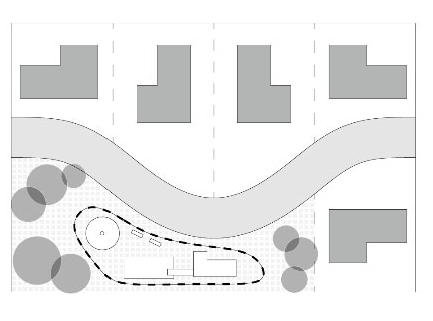 | A Playground provides space for supervised recreation for children within a neighborhood, or as part of a larger neighborhood or community park. | • Shall be designed with commercial grade play equipment |
| • Minimum area of two thousand (2,000) square feet with no maximum requirement | |||
| Square | 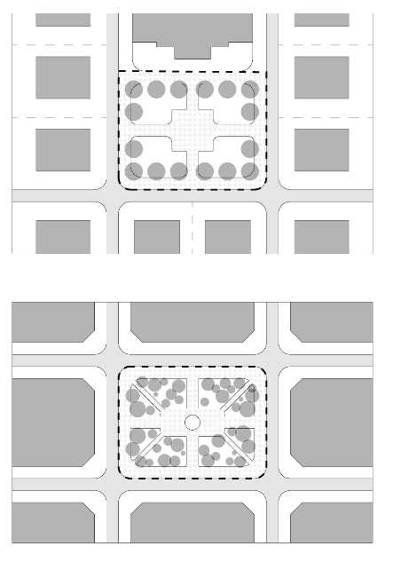 | A Square provides a means to emphasize important places, intersections, or centers. | • Shall be bound by streets on a minimum of three (3) sides or seventy-five (75%) percent |
| • May be bound by front facing lots on one (1) side or twenty-five (25%) percent of their perimeter | |||
| • No rear facing lots allowed adjacent to a square | |||
| • Tree planting is encouraged parallel to the street right-of-way | |||
| • Minimum area of two thousand (2,000) square feet up to a maximum area of two (2) acres | |||
| Plaza | 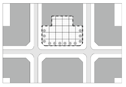 | A Plaza is an outdoor area for community leisure that is entirely bounded by streets, lanes, or buildings. | • Shall maintain an orthogonal shape that is parallel to a bounded street, lane, or building |
| • Shall be level, stepped or gently sloping | |||
| • Minimum area of four thousand (4,000) square feet up to a maximum area of one (1) acre | |||
| Community Park | 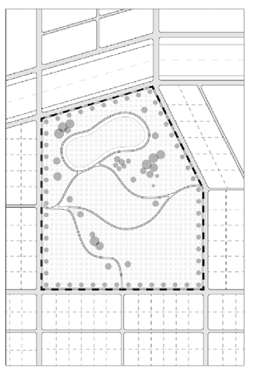 | Community Parks are designed for active and passive recreational use. Community Parks create a central open space that services an entire neighborhood or group of neighborhoods or incorporates physical features that are an asset to the community. | • Trees shall be planted at the edge of community park boundaries |
| • Shall be bounded by streets on a minimum of fifty (50%) percent of their perimeter | |||
| • Minimum area of twenty thousand (20,000) square feet with no maximum requirement |
(c)
Aesthetic quality.
(1)
When appropriate, streets should terminate at a focal point, which may be a community park, bell tower, permanent art installation, or other similar feature.
(2)
The location and width of residential garage doors shall be designed so as to not dominate the streetscape. Standards on garage width and garage setbacks should be used to ensure that garage doors do not dominate the streetscape.
(3)
Attached housing shall be designed to reduce the monolithic nature of the structure.
(4)
Fences, walls, and berms should be designed and maintained in relationship with the character of the surrounding land uses and structures. Retaining walls should be constructed of architectural masonry or faced with rock, brick, and/or constructed to blend with adjacent surroundings.
(5)
Detention and retention structures are discouraged in areas subject to view from a public street if not used both for aesthetic purposes and designed so as to not require a fenced enclosure.
(6)
Mixed Residential Districts are encouraged to utilize creative methods for stormwater management, when such methods provide additional open space opportunities.
(7)
Service and loading zones shall be located to minimize visibility from public streets and neighboring properties.
(d)
Site development.
(1)
Transitions at property edges should seem natural for the surrounding terrain.
(e)
Parking.
(1)
Decorative fences or walls, plantings, berms, or other similar features shall be used to screen surface parking lots from public view or soften their visual impact.
(2)
The location and design of parking structures should minimize their visibility from the street or other public areas.
(3)
Surface parking lots should be oriented behind or to the side of a building when possible. Surface parking lots should not be located on street corners.
(4)
The architectural features of a parking deck or structure shall be constructed of similar materials, colors, and detailing to match those used on the rest of the principal structure(s).
(f)
Pedestrian scale.
(1)
Comfortable and attractive street furniture shall be provided in active community spaces for public enjoyment, comfort, and convenience. These may include seats and benches, drinking fountains, trash receptacles, information kiosks, directories, or other similar features.
(2)
Clear pedestrian and visual paths shall be established using a combination of covered arcades, covered walkways, courtyards, landscape patterns, consistent paving materials, minimal interruption of pedestrian paths, and other similar features.
(3)
Sidewalks shall be present in all residential areas.
(4)
All streets, pedestrian paths and trails within the Mixed Residential District shall remain ungated for public access.
(g)
Landscape and natural environment.
(1)
Specific emphasis should be placed on the preservation or planting of trees between buildings and the street.
(2)
Existing topography, significant tree cover, state waters and other natural features should be considered and incorporated into the project design whenever possible.
(3)
Required open space should be distributed throughout the project.
(4)
Landscaping shall provide buffering between non-compatible land uses.
(h)
Built environment.
(i)
Residential developments shall avoid large box-like forms with continuous unrelieved surfaces. Building articulation shall be included on attached residential facades which can be in the form of horizontal and vertical stepbacks, changes in roof form and height, and major full-height recesses along the length of the building that break the building into discrete smaller masses.
(Amd. of 10-20-2022)
20B-3.4. - General conditions.
(a)
Code provisions. Whenever there is a conflict or difference between the provisions of this article and those of other chapters of the Unified Development Code, the provisions of this article shall prevail. Subjects not covered by this article shall be governed by the respective provisions found elsewhere in the Unified Development Code.
(b)
Water and sewer. Public water with sufficient flow volume and pressure to meet water supply and fire flow needs shall be required for all mixed residential districts. Public sewer or an existing private sewage treatment plant with sufficient treatment and collection system capacity shall be required for all mixed residential districts.
(c)
Variance requests. Applications requesting rezoning to the mixed residential district must identify all variance requests in the rezoning application and represent such requests in the Master Development Handbook. Variances shall be limited to the requirements of the Unified Development Code and shall follow the requirements of chapter 8.
(Amd. of 10-20-2022)
20B-3.5 - Procedures.
(a)
Pre-application meeting. Before submitting an application for rezoning to mixed residential district, the applicant shall schedule a pre-application meeting with planning staff and the district commissioner to determine the feasibility for the proposed plan and its relationship to the Forsyth County Comprehensive Plan and the Unified Development Code. The application can only advance to the planning commission with the support of the district commissioner. Support of the district commissioner for the application to proceed shall not limit the district commissioner's discretion in voting on the application.
(b)
Master development handbook. To enable a thorough analysis of an application for the mixed residential district, the application requirements exceed those of other zoning districts. In addition to the standard requirements, applications for the mixed residential district shall include a Master Development Handbook. The handbook shall illustrate design criteria per section 20B-3.3 in addition to proposed land use standards listed below. To avoid duplication, the information required for the Master Development Handbook can be combined with the standard requirements to amend the official zoning map. The Master Development Handbook shall include:
(1)
The Uniform Plan. A plan of the project showing the location of proposed zones and the general trajectories of the various thoroughfares. The Uniform Plan shall differentiate between the following zones:
(a)
Residential Zones with separate designations for varying housing types.
(b)
Open Space Zones with active community spaces identified.
The applicant may develop more specific zones and or modify the name of the zones to better represent the theme of the proposed mixed residential district. See section 20B-3.2 for requirements related to permitted uses.
(2)
Land use standards. A matrix of text and or diagrams that regulate the permitted uses and performance standards for each zone identified in the Uniform Plan. Regulations of the Unified Development Code that are not listed in the Land Use Standards shall default to the standards identified in other chapters, which will be determined by the director in any case in which applying the regulations of other chapters would be unclear. At a minimum, the following land use standards shall be established for each zone identified in the Uniform Plan:
(a)
Permitted uses.
(b)
Minimum lot size.
(c)
Minimum lot width.
(d)
Minimum setbacks.
(e)
Minimum building separation.
(f)
Buffers and impervious surface setbacks.*
(g)
Maximum height.
(h)
Maximum building coverage.
(i)
Parking and loading requirements.
*Riparian buffers and impervious surface setbacks as set forth in UDC 18-11.2 shall not be modified except via the process in UDC 18-11.3.
(3)
Community standards. The community standards are intended to produce visual compatibility among various building types and, at a minimum, the community standards shall address lighting, signage, fences, landscaping, building materials, building colors, and other architectural features. The following shall be submitted to address each of the community standards:
(a)
Lighting. A pedestrian scale lighting illustration that demonstrates the relationship of the pedestrian to street light features and types and styles of light fixtures that will be used.
(b)
Fences. Fence and wall details that demonstrate a cohesion in material and maintain a relationship with the character of the surrounding land uses and structures.
(c)
Landscaping. A landscape plan that incorporates planting materials to enhance the existing area, particularly as viewed from an adjacent right-of-way, and to mitigate development impacts.
(d)
Building materials. Building elevations and details pertaining to wall finishes with indication of the wall cladding material.
(e)
Building colors. Building elevations or renderings demonstrating the permissible colors for materials on walls, roofs, and any accent feature.
(f)
Architectural features. Details pertaining to elements found in the built environment that create community character and visual interest.
(4)
Phasing standards. The phasing standards shall consist of a construction phasing schedule and plan for phased projects. Phased projects shall comply with the following criteria:
(a)
For all mixed residential district developments, upon completion of the initial phased development, the proposed future phases shall remain as accessible open space areas, provided the land is undisturbed and not hazardous to the health, safety, and welfare of residents and the public, until such time that the proposed portion will be constructed.
(5)
Additional requirements. Text and or diagrams providing the following information:
(a)
Method of water and sewer service, including verification of capacity;
(b)
A summary of the anticipated maintenance and ownership of streets and open spaces;
(c)
Proposed maximum number of residential dwelling units by type and minimum lot size;
(d)
A plan identifying the existing tree canopy. Information available from the county's GIS data is acceptable for the rezoning stage;
(e)
Existing topography with contour intervals no greater than four feet. Information available from the County's GIS data is acceptable for the rezoning stage;
(f)
State waters, wetlands, and floodplains. Information available from the County's GIS data is acceptable for the rezoning stage;
(g)
A summary of issues related to connectivity. The information should include available information on private and public streets; significant vehicular parking and loading areas; the provision of bicycle parking areas, paths, sidewalks, and other similar features; and interconnections to adjoining property; and
(h)
The design of all building façades, including exterior finish materials, architectural elements, and other details necessary to clarify exterior features.
(Amd. of 10-20-2022; Amd. of 5-4-2023; Amd. of 11-2-2023)
20B-3.6. - Amendments.
(a)
Conformance to approved Master Development Handbook. All further development of the property shall conform to the approved Master Development Handbook, regardless of any change in ownership, unless the county approves minor or major amendments.
(b)
Minor amendments. The director may approve minor amendments to the approved Master Development Handbook, which are in compliance with the provisions and intent of this article, and do not depart from the principal concept of the approved Master Development Handbook. Minor amendments are those determined by the director to meet the purpose and intent of the Mixed Residential District, which would not affect adjacent properties. Minor amendments shall be approved as part of the land disturbance permitting process. The director may require the applicant to provide written justification for the minor amendment if such justification is not evident within the land disturbance permit itself.
(c)
Major amendments. Should the director determine that a requested change or deviation from the approved Master Development Handbook departs from the principles of the Master Development Handbook and would affect adjacent properties, the proposed modification will be classified as a major amendment. The applicant may apply for approval of a major amendment to the board of commissioners as an application for modification of conditions of zoning, as established in chapter 8 article IX of this Code.
(Amd. of 10-20-2022)