
Morgan Hill City Zoning Code
CHAPTER 18
29 - MONTEREY CORRIDOR FORM-BASED CODE
18.29.010 - Introduction.
A.
Purpose of the Form-Based Code. The form-based code (FBC) represents a paradigm shift in the way that the built environment is regulated. The formal short definition of a form-based code is as follows:
"A form-based code is a land development regulation that fosters predictable built results and a high-quality public realm by using physical form (rather than separation of uses) as the organizing principle for the code. A form-based code is a regulation, not a mere guideline, adopted into city, town, or county law. A form-based code offers a powerful alternative to conventional zoning regulation."
- Form-Based Codes Institute
Unlike conventional, use-based codes, FBCs utilize the intended form and character of a neighborhood, rather than use as the organizing framework of the code. Morgan Hill will join cities and counties across the country that are now utilizing FBCs to shift their "main streets" and commercial corridors into vibrant, mixed-use areas where residents can live, work, and play within close walking distance.
For the Monterey Corridor (Corridor), the FBC establishes development standards that are objective and implement the community vision, emphasizing pedestrian-oriented building form and streamlined housing development with an appropriate mix of uses. The FBC is designed with a user-friendly organizational structure, where city staff and community members can easily navigate and recognize the standards and requirements that apply to the applicable development site.
Regulations and standards in a FBC are presented graphically in simple diagrams and photographs as well as supplemental text. These standards are keyed to a plan (i.e., a regulating plan) that functions like a zoning map, assigning an appropriate form and scale through the application of form-based zones to specific lots. While FBCs focus on an intended physical form, they also regulate use by allowing a mix of appropriate land uses chosen to ensure compatibility among different contexts and the intended physical form of the area. The standards ultimately shape the relationship between building facades and the public realm (i.e., the public and private space between buildings), the form and mass of buildings in relation to one another, and the scale and type of blocks.
B.
Organization of the Form-Based Code. The following advisory text is intended to give a brief overview of the overall structure of Chapter 18.29 (Form-Based Zoning Districts).
1.
Section 18.29.010: Introduction. This section introduces the FBC, describes its components, and provides an illustrative explanation of how to use and apply the FBC to a typical development review application.
2.
Section 18.29.020: Purpose and Applicability of the Form-Based Code. This section provides the general purpose and intent of the form-based zoning districts and standards, as well as the applicability of the FBC.
3.
Section 18.29.030: Form-Based Zoning Districts. This section establishes the applicability of the form-based zoning districts, an overview of the zoning districts, and the specific purpose statements and development standards associated with each zoning district.
4.
Section 18.29.040: Building Type Standards. This section establishes the purpose and intent of the building type standards, the applicability of the standards, a description of each building type, and objective standards associated with each type.
5.
Section 18.29.050: Frontage Type Standards. This section establishes the purpose and intent of the frontage type standards, the applicability of the standards, a description of each frontage type, and objective standards associated with each type.
6.
Section 18.29.060: Civic Space Standards. This section establishes the purpose and intent of the civic space standards, the applicability of the standards, a description of each civic space type, and objective standards associated with each type.
7.
Section 18.29.070: Land Use Standards. This section establishes the land uses permitted in each form-based zoning district and any applicable specific use standards.
8.
Section 18.29.080: Standards Supplemental to Form-Based Zoning Districts. This section provides any additional standards or requirements necessary to implement walkable areas, including additional standards for landscaping, outdoor lighting, open space, signs, and a cross-reference to parking and loading standards (See Chapter 18.72, Parking and Loading).
9.
Section 18.29.090: Permits and Administration for Form-Based Zoning Districts. This section establishes any additional or unique provisions necessary to administer the FBC.
10.
Section 18.29.100: Definitions for Form-Based Zoning Districts. This section provides any additional or unique definitions necessary to understand the standards and requirements of the FBC.
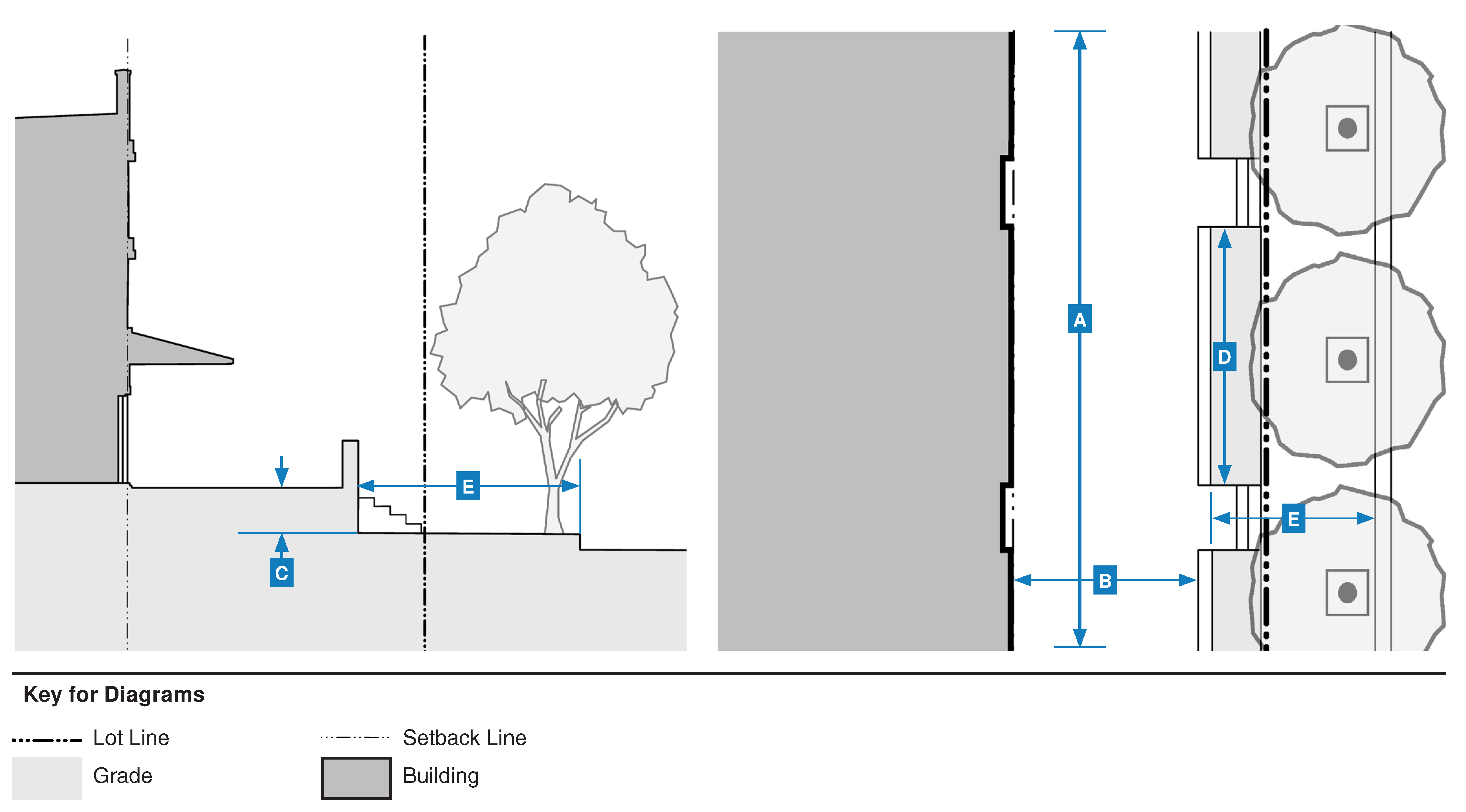
18.29.010.C
How to Use the Form-Based Code
Figure 18.29-1 How to Use the Form-Based Code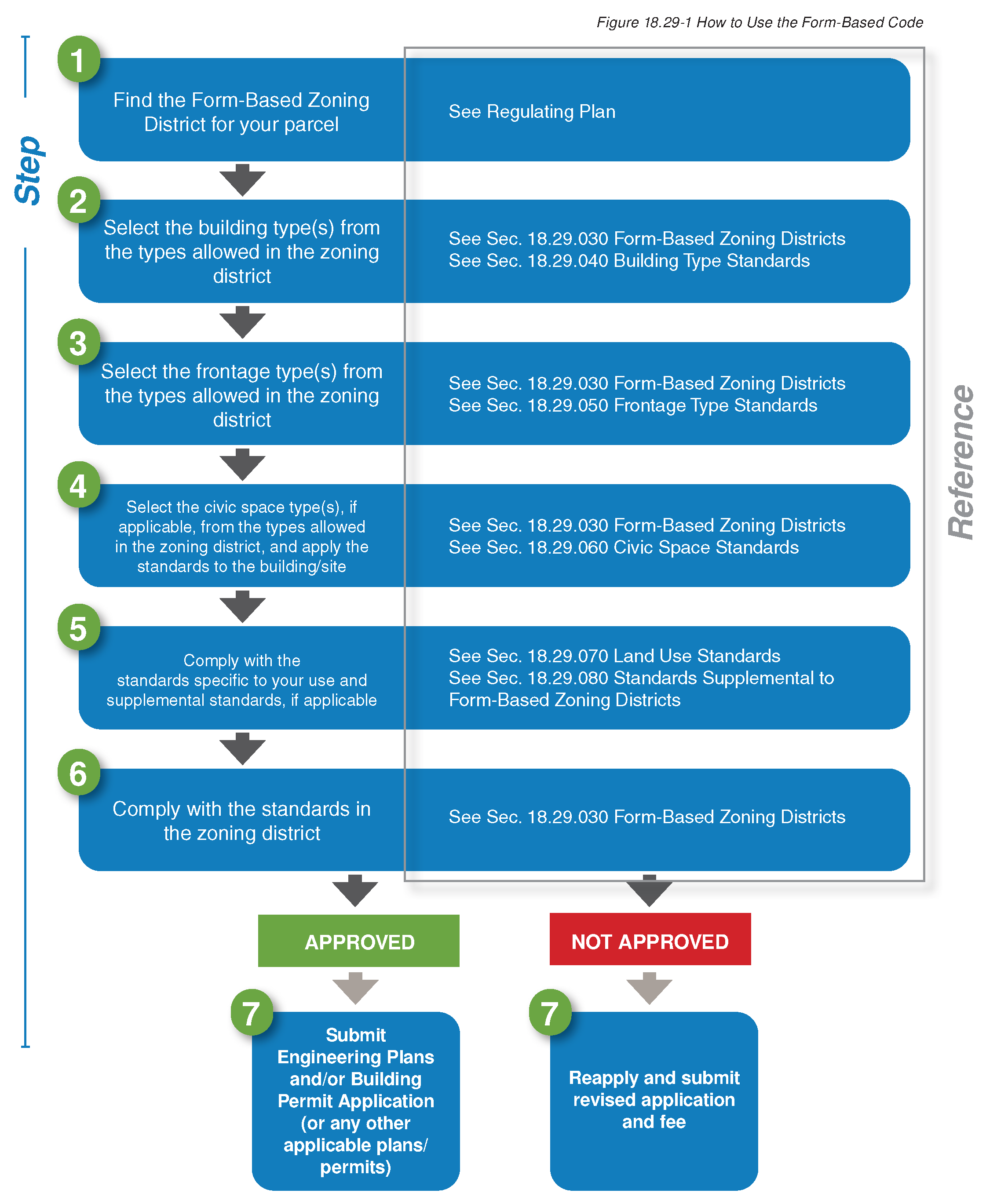
(Ord. No. 2348, N.S., § 3(Exh. B), 9-6-2023)
18.29.020 - Purpose and applicability of the form-based code.
A.
Title. Chapter 18.29 (Form-Based Zoning Districts) of the Morgan Hill Municipal Code shall be known and may be cited as the form-based code. Within this chapter, it may also be known as the "FBC."
B.
Purpose. The purpose of the FBC is to implement the general plan, specifically the general plan's vision for the corridor as a "vibrant mixed-use corridor that encourages walking and biking," through standards for neighborhood design, building form, and land use. The specific purpose and intent of each zoning district is established in Section 18.29.030 (Form-Based Zoning Districts).
C.
Applicability.
1.
This chapter applies to all new uses and projects on land delineated in the form-based code regulating plan map. This area may be known and referred to as the "FBC Area."
2.
If any provision within this chapter conflicts with another chapter of the Zoning Code, the FBC shall control.
3.
Where the FBC is silent or does not provide an explicit provision, the Zoning Code shall apply.
4.
Any requirement of state law will supersede any provision of this chapter.
(Ord. No. 2348, N.S., § 3(Exh. B), 9-6-2023)
18.29.030 - Form-based zoning districts.
A.
Purpose and Intent
1.
General. The purpose of the form-based zoning districts is to provide for active, vibrant, and walkable destinations and neighborhoods in Morgan Hill with a diversity of residential and commercial land uses. The form-based zoning districts support a range of housing products, pedestrian-friendly public realm, and vertical and horizontal mixed-use projects. The diversity of pedestrian-friendly development, land uses, and general level of activity in the form-based zoning districts is intended to support a range or transportation choices, including walking, biking, and transit.
2.
Specific. For specific intent statements, see each form-based zoning district established in this section.
B.
Overview of Form-Based Zoning Districts. Table 18.29-1 provides an overview of each form-based zoning district.
Table 18.29-1 Summary Table of Form-Based Zoning Districts
| Zoning District | Neighborhood Form-Based (FB-N) | Corridor Form-Based (FB-C) | Urban General Form-Based (FB-UG) |
|---|---|---|---|
 |  |  | |
| Desired Form | Medium setbacks | Buildings placed at or near ROW | Small to large setbacks |
| Neighborhood character | Mixed-use, walkable character | Mixed-use, walkable urban character | |
| Heights up to 35 ft. | Heights up to 45 ft. | Heights up to 55 ft. | |
| Compatible with neighborhood context | Diverse mix of building frontages | Diverse mix of building frontages | |
| General Use | Residential with both detached and attached dwellings that offer a variety of housing options in a range of densities close to neighborhood-serving commercial uses. | Primarily ground floor commercial or service uses with a mix of commercial, residential, service, and/or office uses on upper stories. | Primarily business-oriented with a variety of supporting uses, including high-intensity residential projects. |
| Intent | A variety of housing opportunities that are accessible to range of income levels in a walkable environment with neighborhood-serving retail and services. | Variable intensities of infill and redevelopment with a mix of walkable uses, such as retail, service, and commercial, that are sensitive to the scale and character of the area. | Mixed-use commercial and residential hubs with a variety of uses and clustered job opportunity centers. Accessible corridors and streets with internal block patterns and an improved pedestrian experience transitioning from an auto-centric environment to a walkable environment. |
| Subsection | 18.29.030.C | 18.29.030.D | 18.29.030.E |
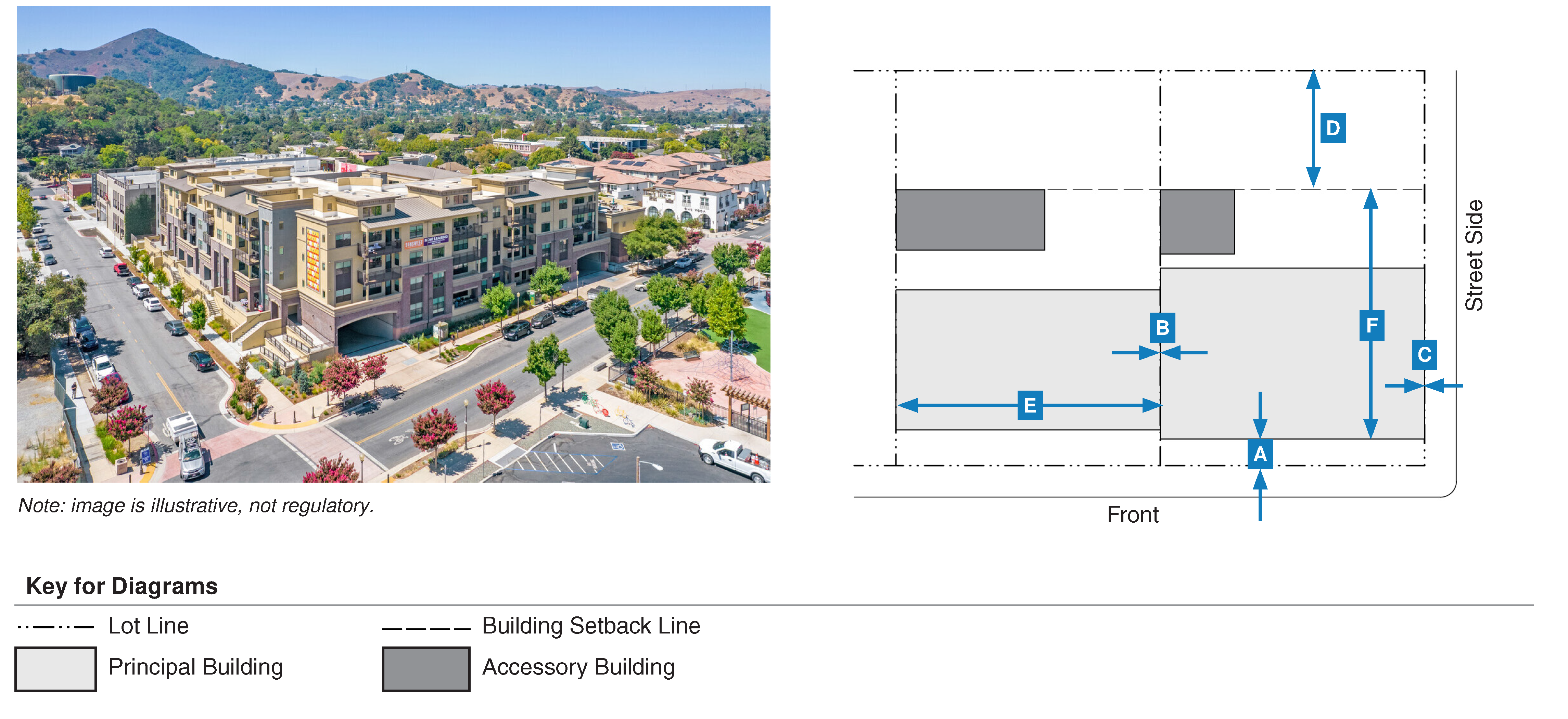
C.
Neighborhood Form-Based (FB-N) Zoning District
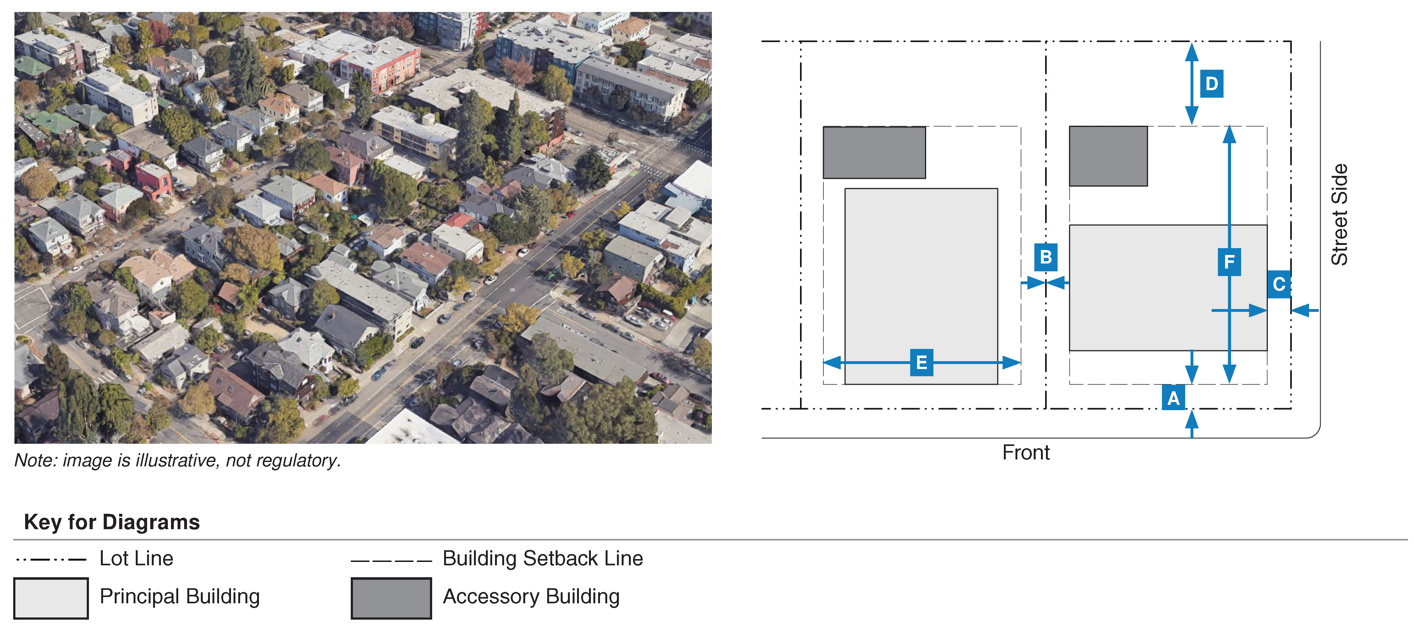
| a. Building Setback | ||
| (i). Front | 5 ft. min., 15 ft. max. | |
| (ii). Interior Side | 5 ft. min. | |
| (iii). Street Side | 5 ft. min., 15 ft. max. | |
| (iv). Rear | 15 ft. min. | |
| b. Build-to-Zone | ||
| (i). Front | 70% min. within setback range | |
| (ii). Street Side | 30% min. within setback range | |
| a. Projections | ||
| (i). Front | 5 ft. max. | |
| (ii). Interior Side | 3 ft. max. | |
| (iii). Street Side | 5 ft. max. | |
| (iv). Rear | 3 ft. max. | |
| b. Height Limit | ||
| 35 ft. max. 1 | ||
| 7. Parking Placement | ||
| Setback | Standard | |
| a. Front | 30 ft. min. | |
| b. Interior Side | 5 ft min. | |
| c. Street Side | 10 ft min. | |
| d. Rear | 0 ft min. | |
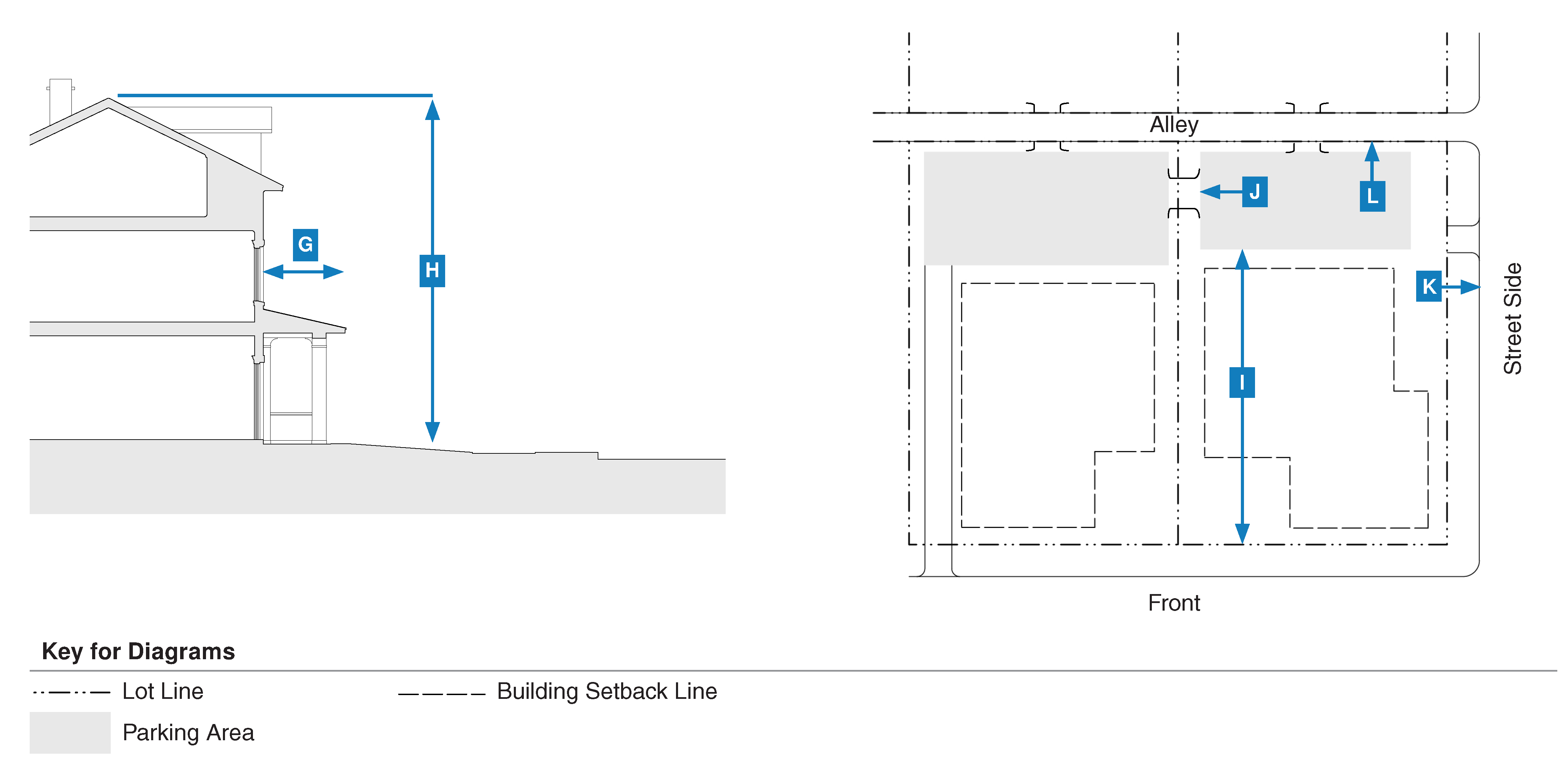
D.
Corridor Form-Based (FB-C) Zoning District
| a. Building Setback | ||
| (i). Front | 0 ft. min., 15 ft. max. | |
| (ii). Interior Side | 0 ft. min. | |
| (iii). Street Side | 0 ft. min., 15 ft. max. | |
| (iv). Rear | 10 ft. min. | |
| b. Build-to-Zone | ||
| (i). Front | 80% min. within setback range | |
| (ii). Street Side | 40% min. within setback range | |
| a. Projections | ||
| (i). Front | 5 ft. max. | |
| (ii). Interior Side | 3 ft. max. | |
| (iii). Street Side | 5 ft. max. | |
| (iv). Rear | 3 ft. max. | |
| b. Height Limit | ||
| 45 ft. max. | ||
| c. Upper Story Setback | ||
| 8 ft. min. required for third story or higher | ||
| 7. Parking Placement | ||
| Setback | Standard | |
| a. Front | 40 ft. min. | |
| b. Interior Side | 0 ft min. | |
| c. Street Side | 10 ft min. | |
| d. Rear | 0 ft min. | |
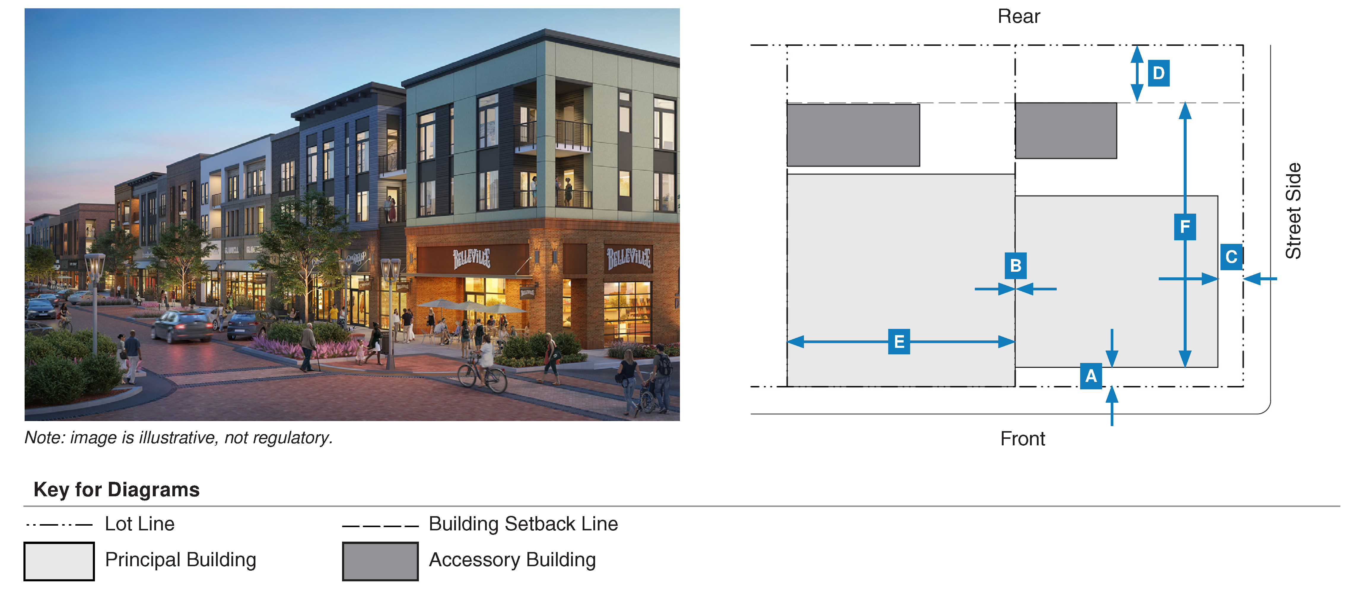
E.
Urban General Form-Based (FB-UG) Zoning District
| a. Building Setback | ||
| (i). Front | 5 ft. min., 25 ft. max. | |
| (ii). Interior Side | 0 ft. min. | |
| (iii). Street Side | 0 ft. min., 25 ft. max. | |
| (iv). Rear | 20 ft. min. | |
| b. Build-to-Zone | ||
| (i). Front | 65% min. within setback range | |
| (ii). Street Side | 25% min. within setback range | |
| a. Projections | ||
| (i). Front | 5 ft. max. | |
| (ii). Interior Side | 3 ft. max. | |
| (iii). Street Side | 5 ft. max. | |
| (iv). Rear | 3 ft. max. | |
| b. Height Limit | ||
| 55 ft. max. | ||
| c. Ground Floor Ceiling Height | ||
| 14 ft. min. | 18 ft. max. | |
| d. Upper Story Setback | ||
| 8 ft. min. required for third story or higher | ||
| 7. Parking Placement | ||
| Setback | Standard | |
| a. Front | 40 ft. min. | |
| b. Interior Side | 0 ft min. | |
| c. Street Side | 10 ft min. | |
| d. Rear | 0 ft min. | |
(Ord. No. 2348, N.S., § 3(Exh. B), 9-6-2023)
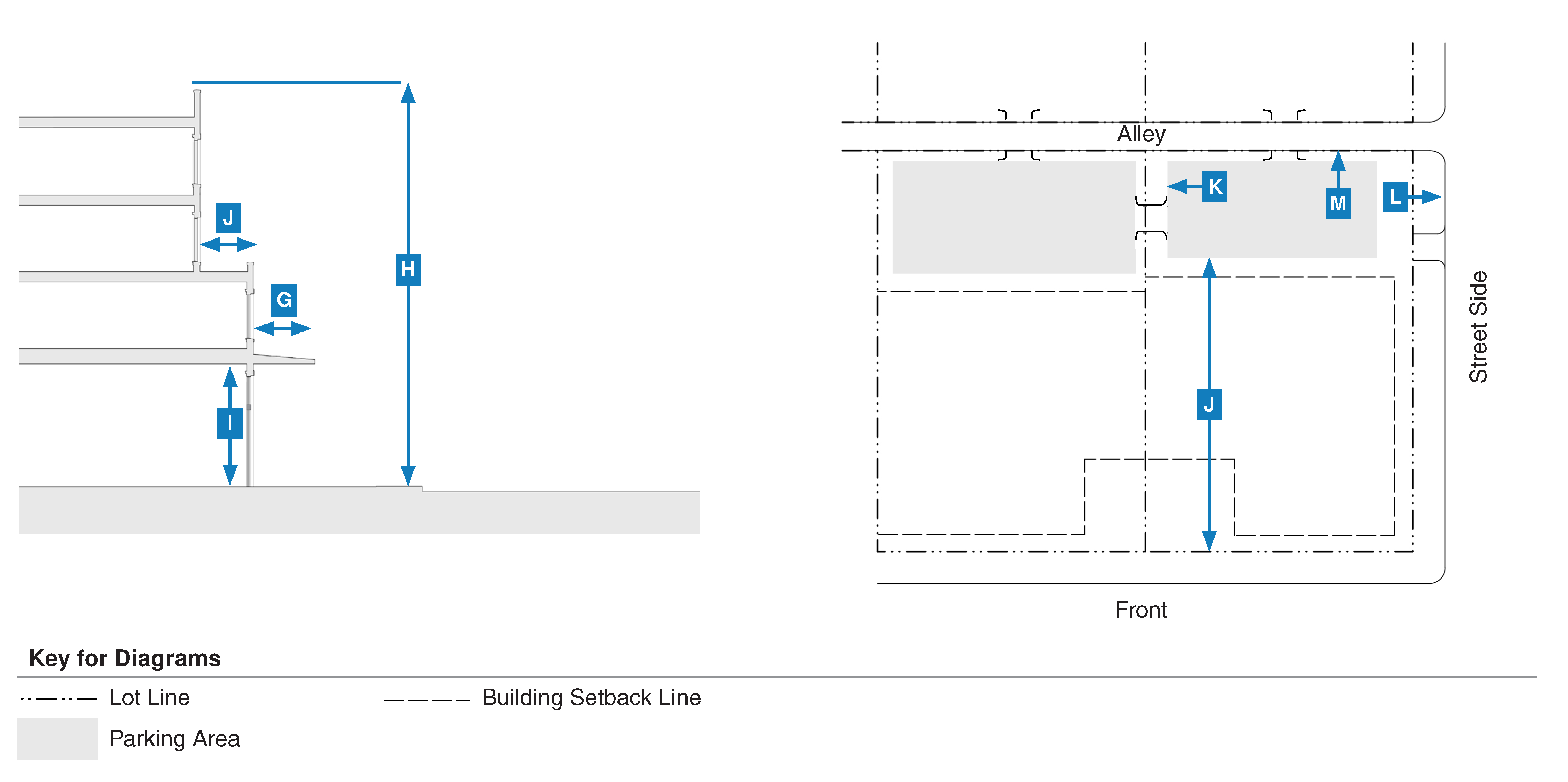
18.29.040 - Building type standards.
A.
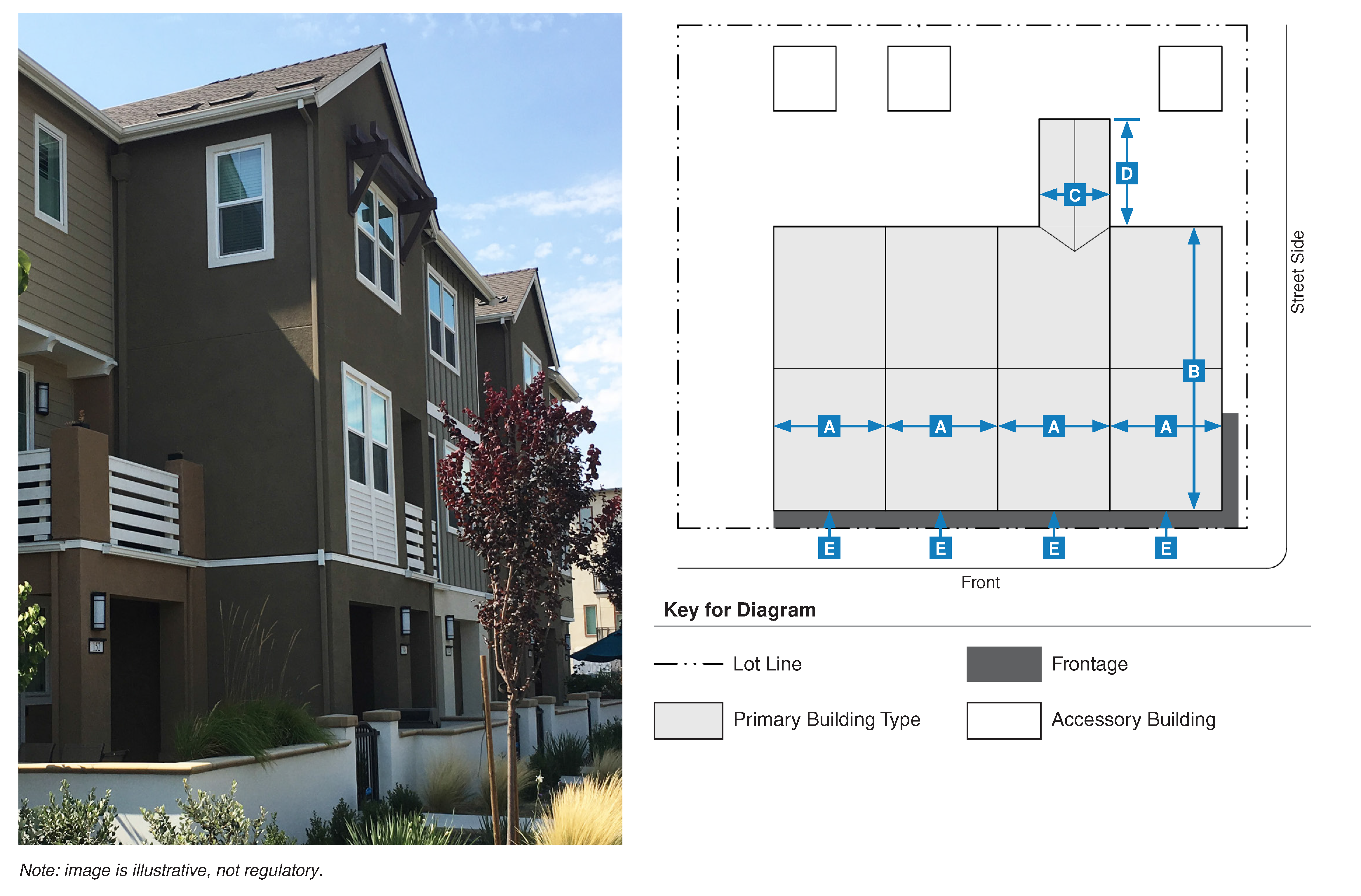
Purpose and Intent. The purpose of this section is to establish standards for all building types within the form-based zoning districts. The standards in this section supplement the standards in Section 18.29.030 (Form-Based Zoning Districts) and are intended to provide a range of housing and development options that reinforce the character and scale of Morgan Hill's history and small-town development pattern.
B.
Applicability
1.
This section applies to all proposed projects within the form-based zoning districts. All new projects in the form-based zoning districts must apply at least one of the building types in this section and be consistent with the identified building type standards and the standards in the applicable zoning district (see Section 18.29.030 (Form-Based Zoning Districts)). The building types support a variety of uses, as allowed in the zoning district (e.g., the "house" building type may include residential uses, eating and drinking uses, professional offices, or others if allowed in the zoning district) (see Section 18.29.070 (Land Use Standards)).
2.
Building types not indicated as "permitted" in the applicable zoning district (see Section 18.29.030 (Form-Based Zoning Districts)) are not permitted in the zoning district.
3.
If an applicant proposes multiple principal buildings on a single lot, the proposal must include potential lot lines in order to determine compliance with this section.
4.
The development of transportation, communications, and/or infrastructure facilities is exempt from this section.
C.
House
| b. Main Body | ||
| Width | 45 ft. max. | |
| Depth | 45 ft. max. | |
| c. Secondary Wing | ||
| Width | 20 ft. max. | |
| Depth | 20 ft. max. | |
| 3. Pedestrian Access | ||
| Primary Entrance | Front Setback | |
D.
Accessory Dwelling Unit
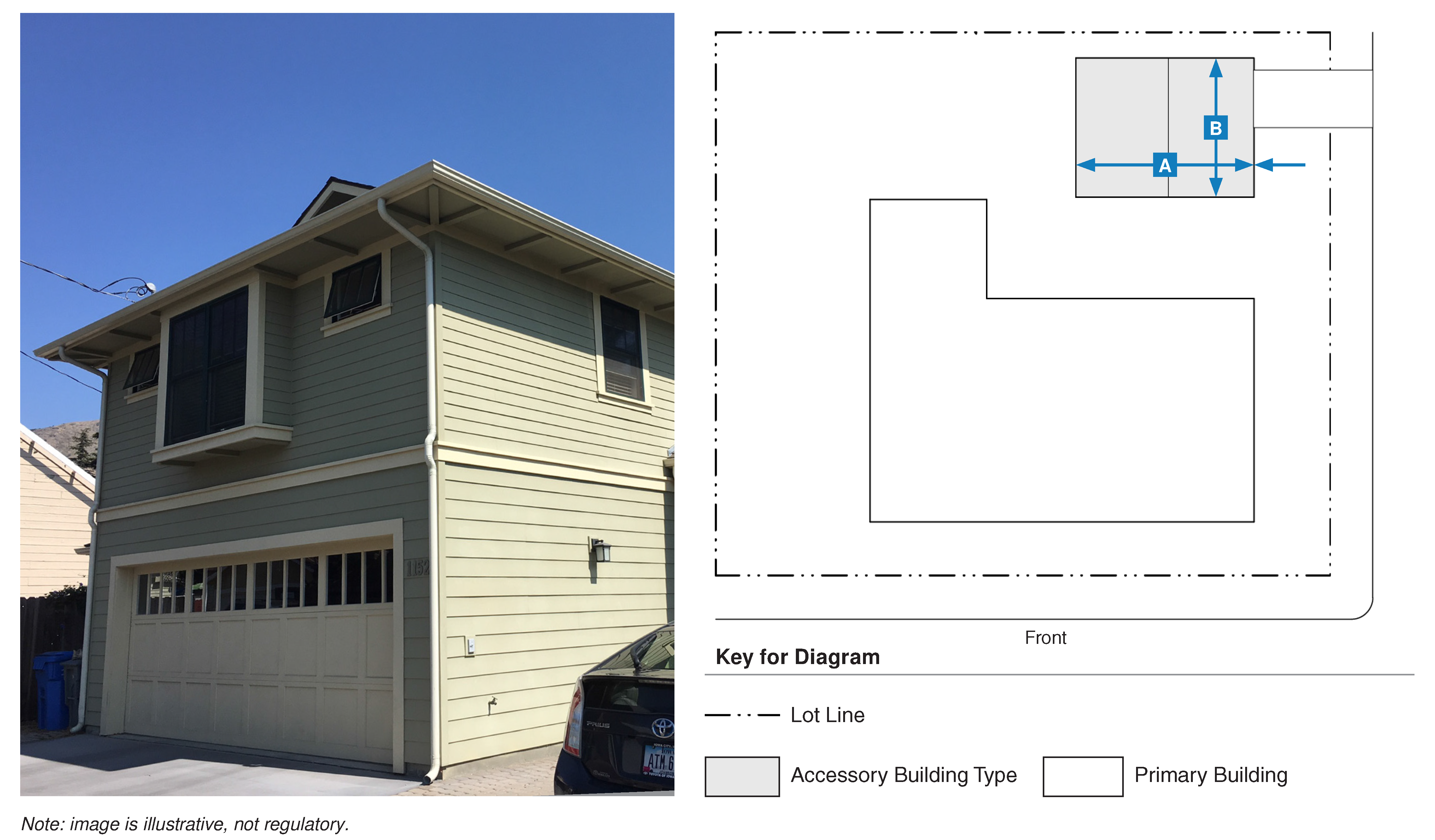
| b. Main Body | ||
| Width | 36 ft. max. | |
| Depth | 30 ft. max. | |
| 3. Pedestrian Access | ||
| Primary Entrance | Street Side Setback, Alley, or Internal to Lot | |
E.
Duplex/Duet
| b. Main Body | ||
| Width | 48 ft. max. | |
| Depth | 40 ft. max. | |
| c. Secondary Wing | ||
| Width | 20 ft. max. | |
| Depth | 24 ft. max. | |
| 3. Pedestrian Access | ||
| Primary Entrance | Front Setback | |
F.
Multiplex Small
| b. Main Body1 | ||
| Width | 45 ft. max. | |
| Depth | 45 ft. max. | |
| c. Secondary Wing | ||
| Width | 20 ft. max. | |
| Depth | 30 ft. max. | |
|
Note:
1. May be exempt from the build-to-zone requirement established in the form-based zoning district if the maximum width and depth preclude the ability to meet the percentage required. | ||
| 3. Pedestrian Access | ||
| Primary Entrance | Front Setback | |
G.
Multiplex Large
| b. Main Body | ||
| Width | 60 ft. max. | |
| Depth | 60 ft. max. | |
| c. Secondary Wing | ||
| Width | 24 ft. max. | |
| Depth | 40 ft. max. | |
| 3. Pedestrian Access | ||
| Primary Entrance | Front Setback | |
H.
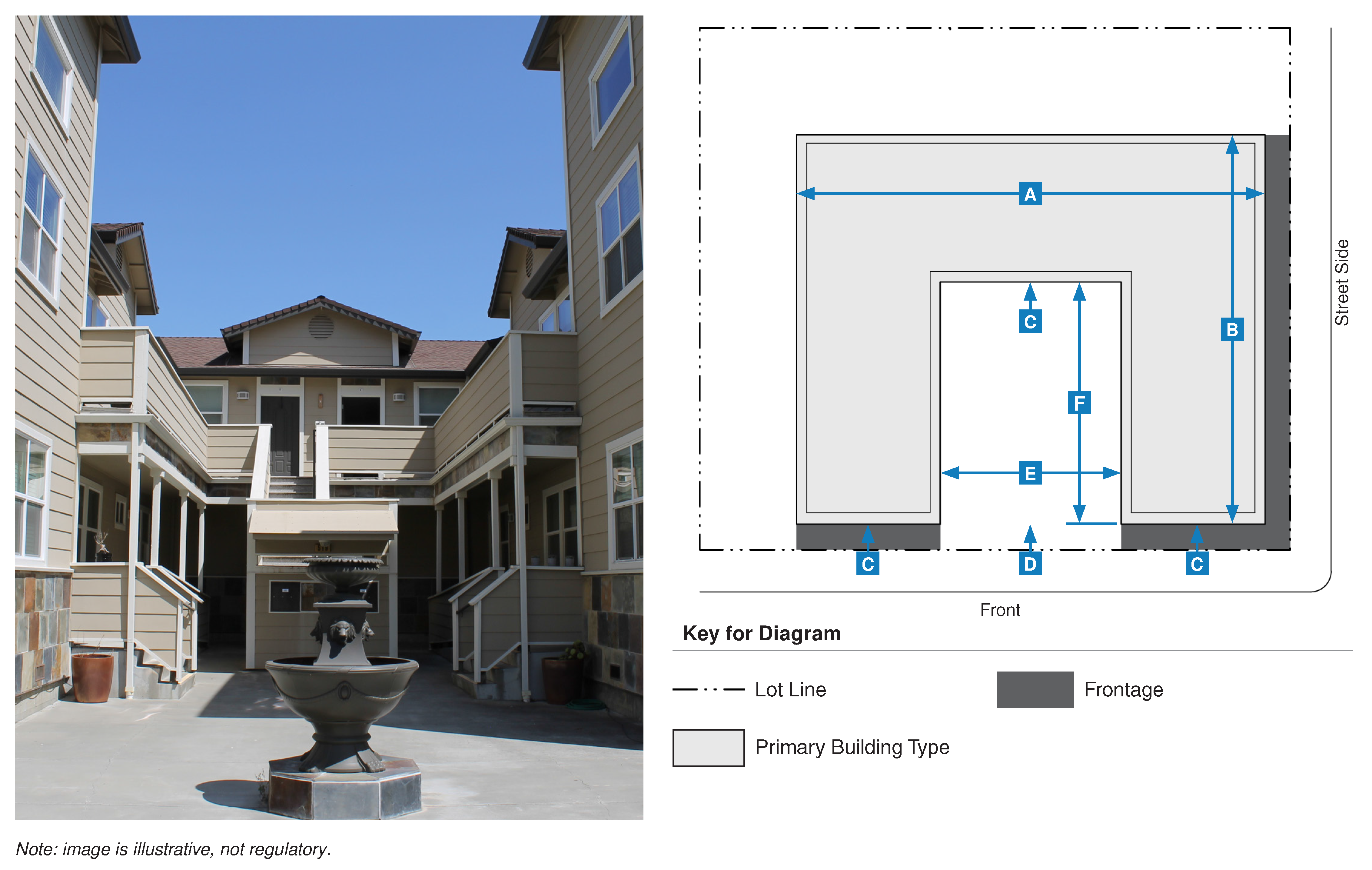
Bungalow Court
| b. Main Body1 | ||
| Width | 32 ft. max. | |
| Depth | 24 ft. max. | |
|
Note:
1. May be exempt from the build-to-zone requirement established in the form-based zoning district if the maximum width and depth preclude the ability to meet the percentage required. | ||
| 3. Pedestrian Access | ||
| Primary Entrance | Shared Courtyard | |
| Shared Courtyard | Accessible from Front Setback/Street | |
| Pedestrian connections shall link all buildings to the shared courtyard, parking area(s), and public right-of-way. | ||
| 4. Common Open Space/Courtyard | ||
| Width | 20 ft. min. | |
| Depth | 3-4 units: 75 ft. min.; 5-9 units: 90 ft. min. | |
| Private open space is not required. | ||
I.
Townhouse
| b. Main Body | ||
| Width | 18 ft. min.; 36 ft. max (per unit) | |
| Depth | 50 ft. max. | |
| c. Secondary Wing | ||
| Width | 14 ft. max. | |
| Depth | 25 ft. max. | |
| 3. Pedestrian Access | ||
| Primary Entrance | Front Setback | |
J.
Courtyard Building
| b. Main Body | ||
| Width | 100 ft. max. | |
| Depth | 100 ft. max. | |
| 3. Pedestrian Access | ||
| Primary Entrance | Front Setback | |
| Shared Courtyard and/or Front Setback/Street | Front Setback/Street | |
| 4. Common Open Space/Courtyard | ||
| Width | 20 ft. min.; 50 ft. max. | |
| Depth | 20 ft. min.; 100 ft. max. | |
| Private open space is not required. | ||
K.
Main Street Building
| b. Main Body | ||
| Width | 200 ft. max. | |
| Depth | 120 ft. max. | |
| 3. Pedestrian Access | ||
| Primary Entrance, Ground Floor Spaces/Units | Front Setback/Street | |
| Primary Entrance, Upper Floor Space/Units | Front Setback, Street Side Setback, Street, or Alley | |
L.
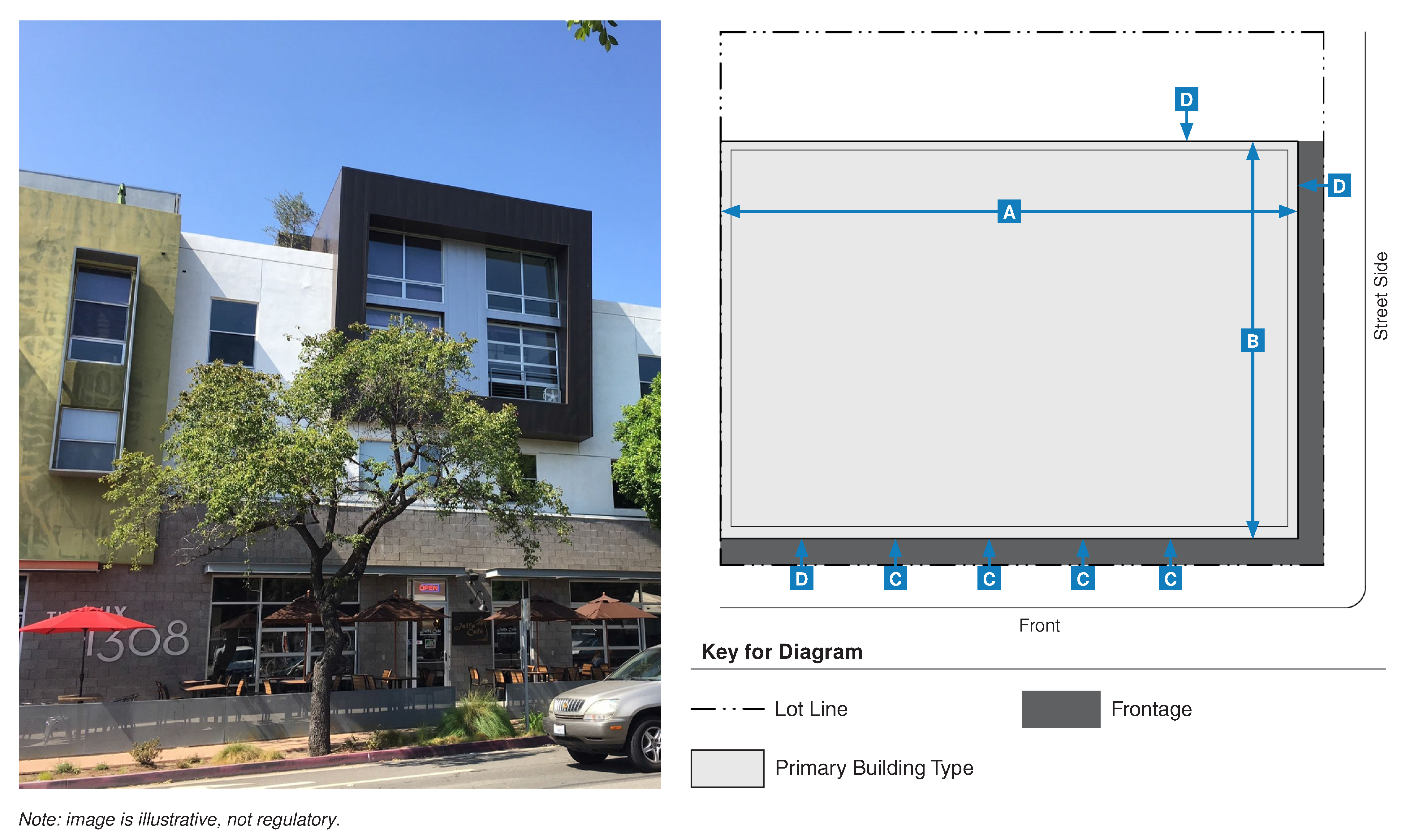
Liner Building
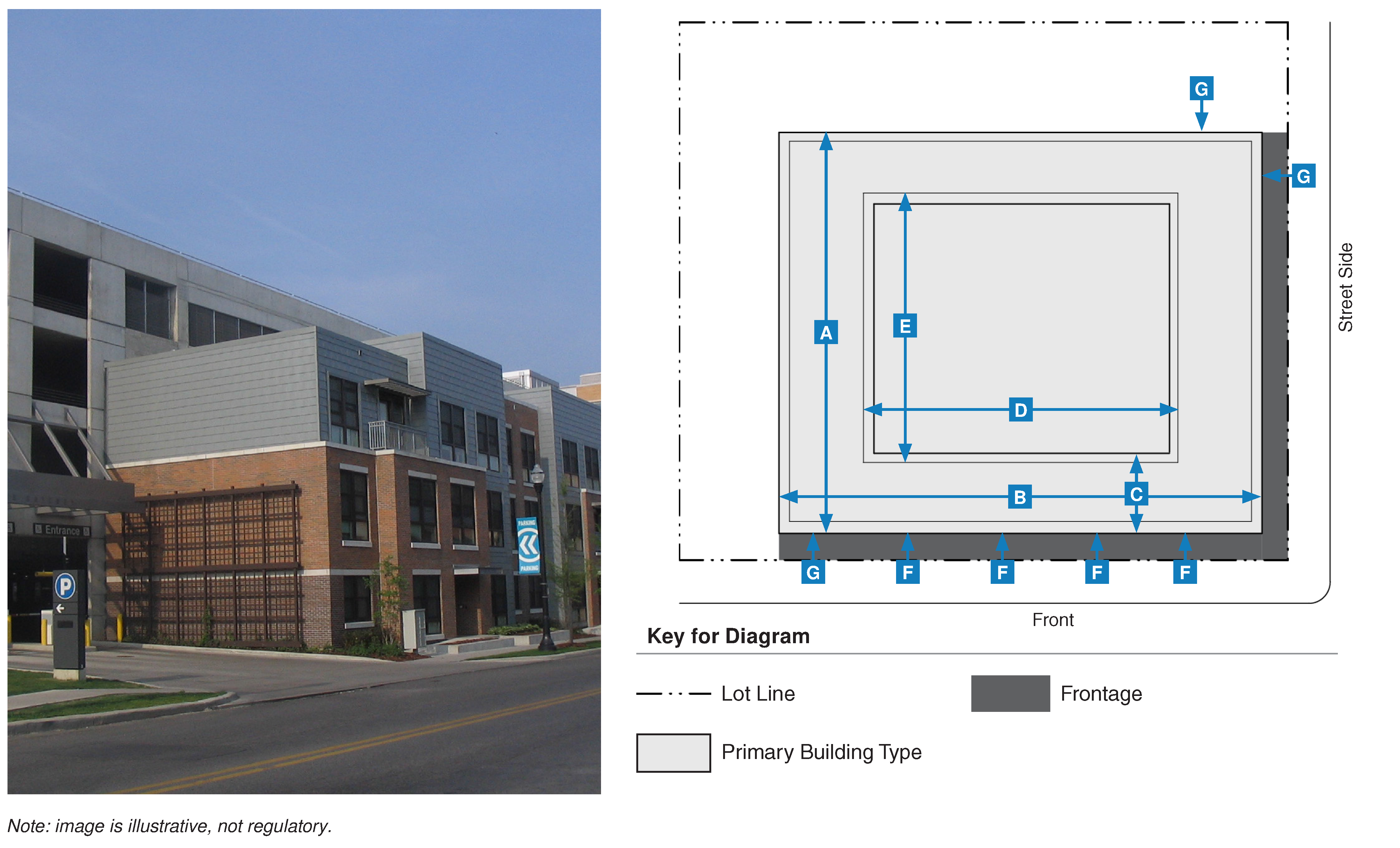
| b. Exterior Building | ||
| Length | 400 ft. max. | |
| Width | 300 ft. max. | |
| Depth | 50 ft. max. | |
| b. Interior Building | ||
| Width | 180 ft. max. | |
| Depth | 230 ft. max. | |
| 3. Pedestrian Access | ||
| Primary Entrance, Ground Floor Spaces/Units | Front Setback/Street | |
| Primary Entrance, Upper Floor Space/Units | Front Setback, Street Side Setback, Street, or Alley | |
(Ord. No. 2348, N.S., § 3(Exh. B), 9-6-2023)
18.29.050 - Frontage type standards.
A.
Purpose and Intent. The purpose of this section is to establish standards for all frontage types within the form-based zoning districts. Private frontages are the components of a building that provide an important transition and relationship between the public realm and private development. The standards in this section supplement the standards in Section 18.29.030 (Form-Based Zoning Districts) and are intended to ensure that development reinforces the character and scale of Morgan Hill's history and small-town development pattern.
B.
Applicability
1.
This section applies to all proposed projects within the form-based zoning districts. The standards in this section must be considered in combination with the standards in the applicable zoning district (see Section 18.29.030 (Form-Based Zoning Districts)).
2.
Frontage types not indicated as "permitted" in the applicable zoning district (see Section 18.29.030 (Form-Based Zoning Districts)) are not permitted in the zoning district.
3.
Every new project and/or structure in the form-based zoning districts must provide at least one frontage type for each street frontage.
4.
The development of transportation, communications, and/or infrastructure facilities is exempt from this section.
C.
Forecourt
| 2. Size | ||
| Width | 15 ft. min. | |
| Depth | 15 ft. min. | |
| Ratio, Width-to-Height | 2:1 max. | |
| Transparency, Ground Floor | 70% min. | |
| Transparency, Upper Floors | 30% min. | |
D.
Front Yard
| 2. Size | ||
| Width | 12 ft. min. | |
| Depth | 10 ft. min. | |
| Height, Fences or Walls 1 | 3 ft. max. | |
E.
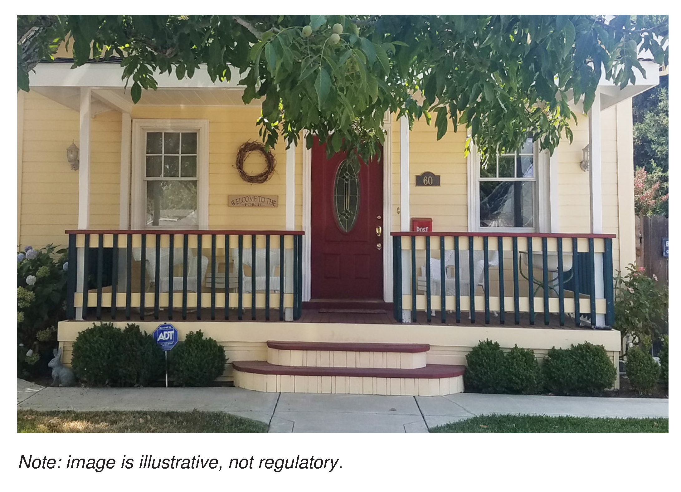
Porch, Engaged
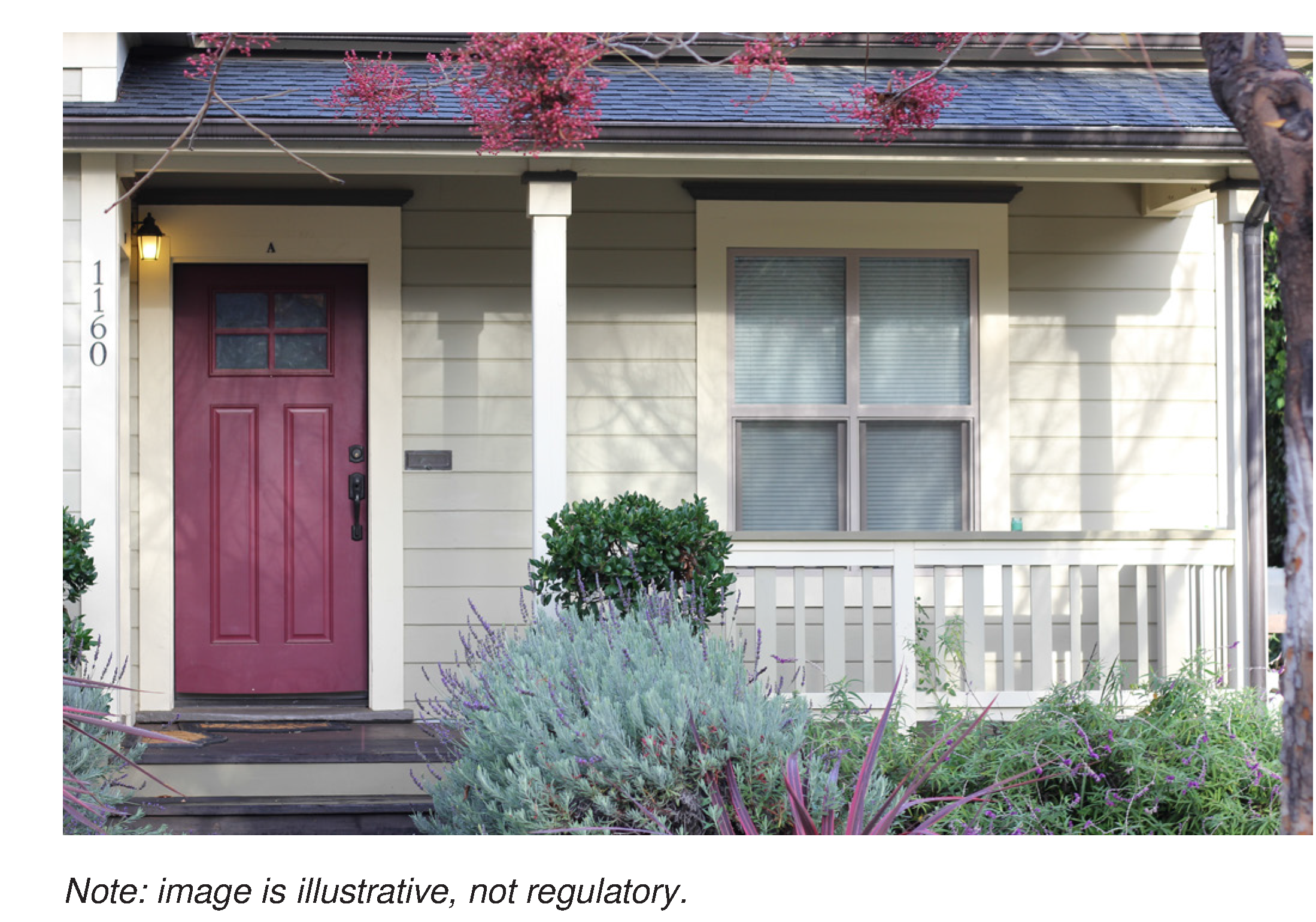
| 2. Size | ||
| Width | 50% min., 80% max. of building width | |
| Depth | 5 ft. min. | |
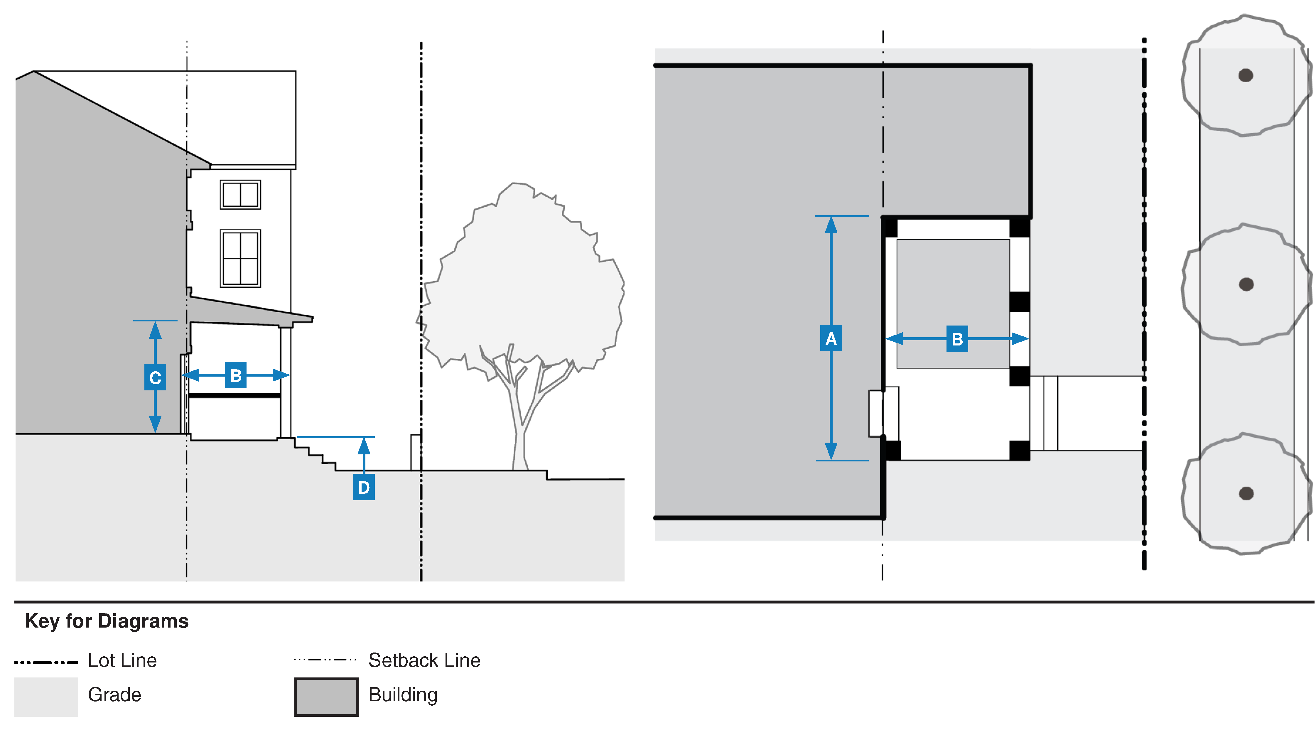
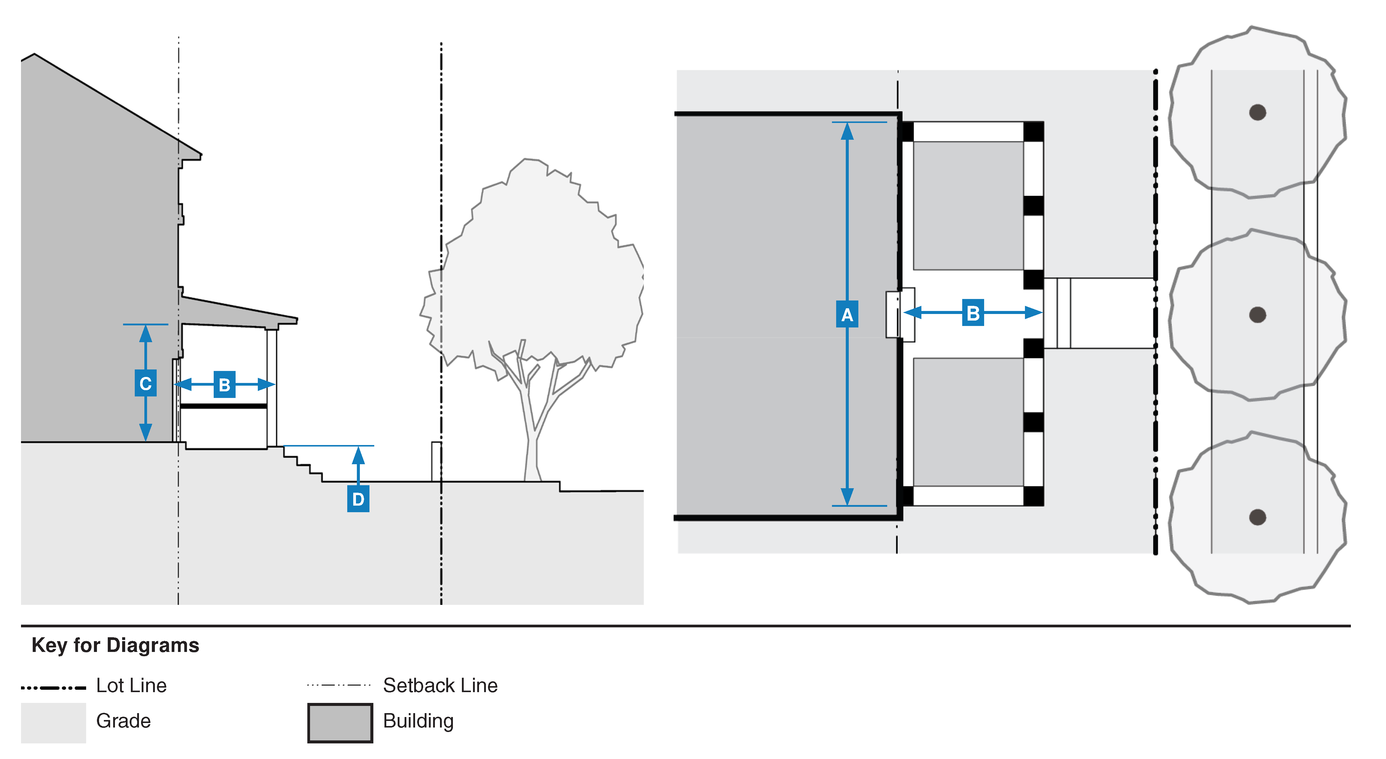
| Height, Clear | 8 ft. min., 14 ft. max. | |
| Finish Level Above Sidewalk | 1.5 ft. min., 6 ft. max. | |
F.
Porch, Projecting
| 2. Size | ||
| Width | 70% min. of building width | |
| Depth | 5 ft. min. | |
| Height, Clear | 8 ft. min., 14 ft. max. | |
| Finish Level Above Sidewalk | 1.5 ft. min., 6 ft. max. | |
G.
Shopfront
| 2. Size | ||
| Entry Recess | 5 ft. max. | |
| Transparency, Ground Floor | 75% min. | |
| 3. Projection 1 | ||
| Depth | 4 ft. min. | |
| Setback from Curb | 2 ft. min. | |
| Height | 8 ft. min. | |
H.
Stoop
| 2. Size | ||
| Width | 4 ft. min., 8 ft. max. | |
| Depth | 4 ft. min., 8 ft. max. | |
| Finish Level Above Sidewalk 1 | 1.5 ft. min., 3 ft. max. | |
I.
Terrace
| 2. Size | ||
| Length | 120 ft. max | |
| Depth | 8 ft. min. | |
| Finish Level Above Sidewalk 1 | 1.5 ft. min., 5 ft. max. | |
| Distance Between Stairs | 25 ft. max. | |
| Wall Setback from Right-of-Way | 5 ft. min | |
(Ord. No. 2348, N.S., § 3(Exh. B), 9-6-2023)
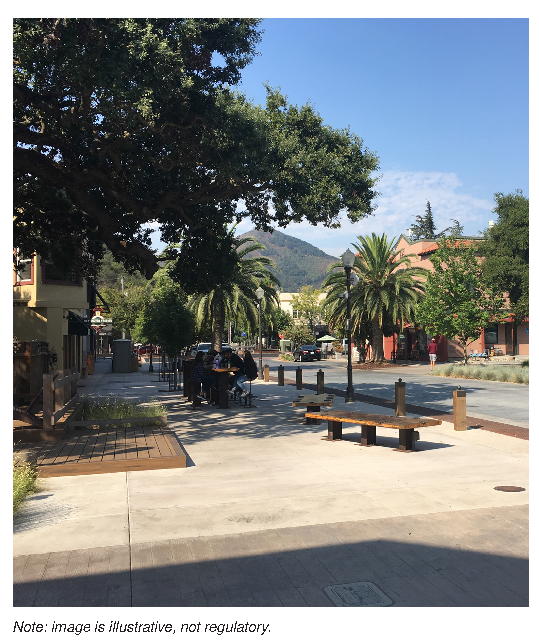
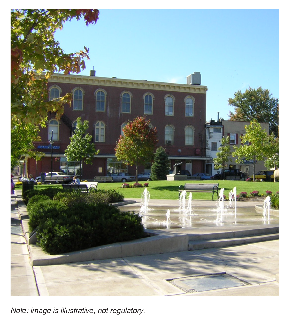
18.29.060 - Civic space standards.
A.
Purpose and Intent. The purpose of this section is to establish standards for all civic space types within the form-based zoning districts. The standards in this section are intended to ensure that publicly accessible civic space is provided to reinforce walkable environments within Morgan Hill.
B.
Applicability
1.
The standards in this section apply to all projects within the form-based zoning districts that meet the following criteria.
a.
All residential projects including twenty or more units must provide one civic space type.
b.
All non-residential or mixed-use projects including two or more structures, or over ten thousand square feet of building space must provide one civic space type.
c.
All projects greater than two acres in total site area must provide a passage and pocket park, or a plaza.
2.
The standards in this section must be considered in combination with the standards in the applicable zoning district (see Section 18.29.030 (Form-Based Zoning Districts)).
3.
Civic space types not indicated as "permitted" in the applicable zoning district (see Section 18.29.030 (Form-Based Zoning Districts)) are not permitted in the zoning district.
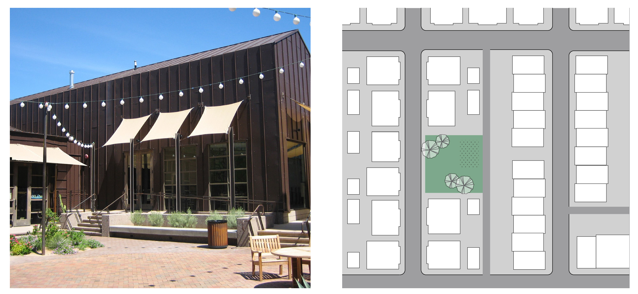
C.
Passage
| 2. Size | ||
| Width | 15 ft. max | |
| Length | 30 ft. min. | |
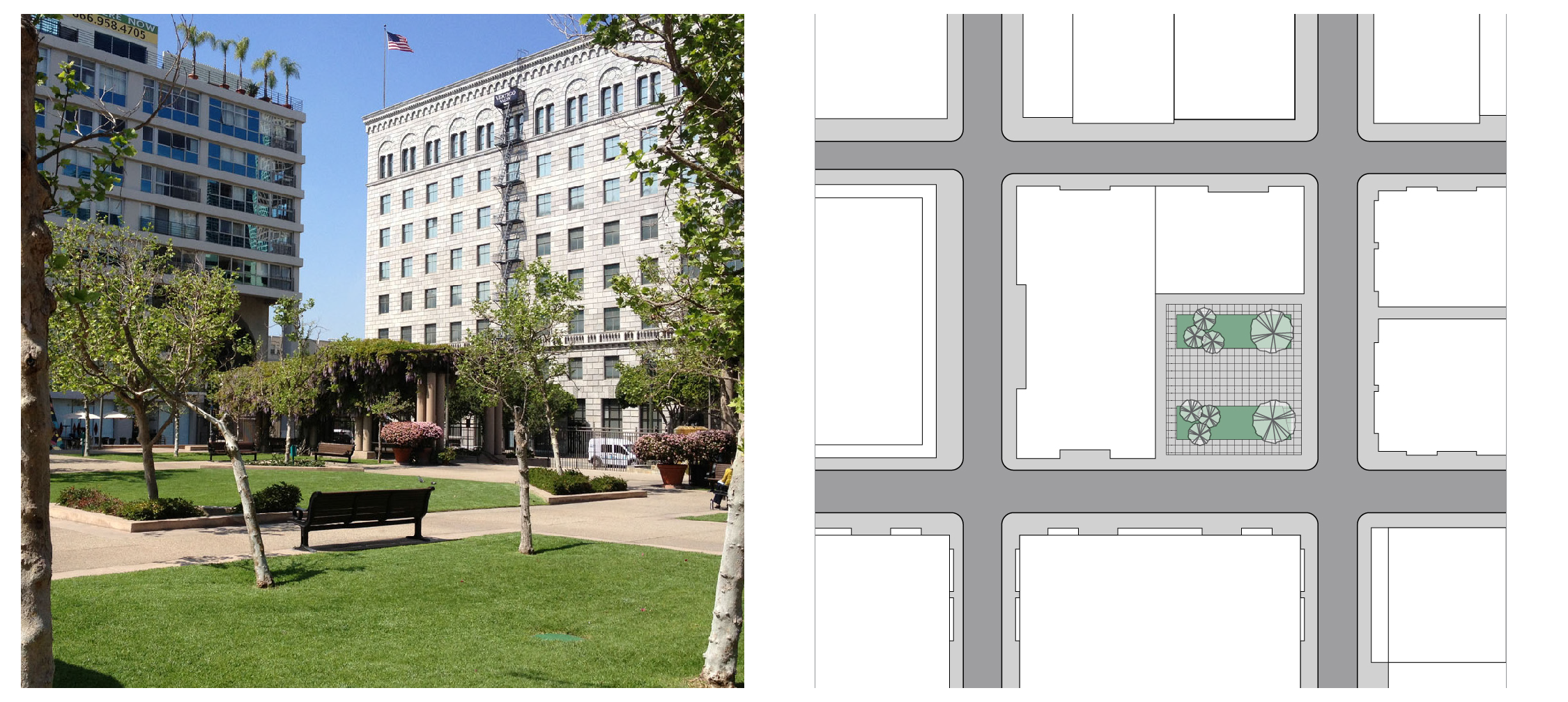
D.
Pocket Park/Plaza
E.
Plaza
(Ord. No. 2348, N.S., § 3(Exh. B), 9-6-2023)
18.29.070 - Land use standards.
A.
Purpose and Applicability
1.
This section establishes the land uses permitted in each form-based zoning district and any specific use standards necessary to implement walkable areas. Where appropriate, land uses may cross-reference to applicable standards in Chapter 18.92 (Supplemental Standards).
2.
Land uses are defined in Chapter 18.124 (Land Use Definitions). If a land use requires a distinct and different definition in the form-based zoning districts, the definition established in Section 18.29.100 (Definitions for Form-Based Zoning Districts) applies.
B.
Permitted Land Uses
1.
Table 18.29-2 (Permitted Land Uses in the Form-Based Zoning Districts), identifies the land uses permitted in the form-based zoning districts by letter designation as follows unless a use or activity is prohibited or subject to a higher level of permit pursuant to other parts of this Code or other applicable regulations.
a.
"P" designates uses permitted by right in the zoning district and is not subject to discretionary review and approval.
b.
"A" designates uses that are permitted after review and approval of an administrative use permit.
c.
"C" designates uses that are permitted after review and approval of a conditional use permit.
d.
"-" designates uses that are not permitted.
2.
A project which includes two or more categories of land use in the same building or on the same site is subject to the highest permit level required for any individual use or single component of the project.
Table 18.29-2 Permitted Land Uses in the Form-Based Zoning Districts
P = Permitted Use
A = Administrative Use Permit required (See Section 18.108.020 (Administrative Use Permits))
C = Conditional Use Permit required (See Section 18.108.030 (Conditional Use Permits))
T = Temporary Use Permit required (See Chapter 18.108.090 (Temporary Use Permits))
- = Use not permitted
C.
Specific Use Standards
1.
Purpose and Applicability
a.
This subsection provides site planning, development, and operating standards for certain land uses where permitted in compliance with Subsection 18.29.070.B (Permitted Land Uses) if necessary to meet the intent of the form-based zoning districts.
b.
This subsection applies to all land uses and development within the form-based zoning districts. If a land use is not specified below, the standards in Chapter 18.92 (Supplemental Standards) apply. If a land use is specified below, the standards in this Subsection supersede any requirements in Chapter 18.92 unless otherwise described below. If a conflict exists between a provision in this Subsection and any other chapter of the Code, the most restrictive provision applies.
c.
Parking for all land uses shall comply with Subsection 18.29.080.E (Parking and Loading Standards).
d.
Signage for all land uses shall comply with Subsection 18.29.080.F (Sign Standards).
2.
Drive-Through Facilities
a.
Design Objectives. A drive-through facility shall only be permitted if the planning commission determines that the design and operation will accommodate pedestrian connections, avoid congestion, and excessive pavement.
b.
Location Limitations.
(i)
A drive-through facility shall only be located along a building facade away from a street frontage.
(ii)
The drive aisle shall not be located between the property line and front of building.
(iii)
The stacking area shall not be located adjacent and parallel to streets or public rights-of-way.
c.
Visual Buffer. The drive aisle shall be screened from streets or public rights-of-way with landscaping or walls and berms.
d.
Drive-Through Lane Capacity. See Subsection 18.92.040.B.
e.
Drive-Through Lane Separation. See Subsection 18.92.040.C.
f.
Pedestrian Access. See Subsection 18.92.040.D.
g.
Drive-Through Lane Setback from Intersection. See Subsection 18.92.040.E.
3.
Multi-Family Dwellings. Walkways in multi-family dwelling developments shall be provided to connect units to recreational and other internal facilities as well as the other residential units and nearby public streets.
(Ord. No. 2348, N.S., § 3(Exh. B), 9-6-2023; Ord. No. 2362, § 5, 2-19-2025)
18.29.080 - Standards Supplemental to Form-Based Zoning Districts
A.
Purpose and Applicability. This section provides standards that are supplemental to the regulations of each form-based zoning district, and are specific to particular aspects of development, such as landscaping, parking, outdoor lighting, and signage. These standards are intended to promote projects that complement the character of Morgan Hill while meeting the intent of the form-based zoning districts.
B.
Landscaping Standards
1.
This subsection provides standards that complement infill development, walkable areas, and built environments that frame the public right-of-way with parking located to the side and rear of structures. Unless otherwise described below, Chapter 18.64 (Landscaping) shall apply.
2.
This subsection applies to the following:
a.
Structures that are located ten feet or fewer from the back of sidewalk; or
b.
Structures that are located on the property line.
3.
Public amenities (e.g., seating), structural shade elements, public art, or potted plants are required in the available space between the back of sidewalk and the structure.
4.
Alternative paving materials (e.g., permeable paving, porous concrete, brick pavers) are permitted in areas between the back of sidewalk and the structure.
5.
The director may accept alternative design solutions consistent with Section 18.29.060 (Civic Space Standards).
C.
Outdoor Lighting Standards
1.
Exterior lighting and parking lot lighting shall be provided, erected and maintained so any light is a fully-shielded light fixture and will not cast direct light or glare upon adjacent properties or public rights-of-way.
2.
A parking area with six or more parking spaces shall include outdoor lighting that provides a minimum illumination of 1.0 foot-candles over the entire parking area.
3.
All outdoor lighting along walkways, open space and recreation areas shall be pedestrian-scaled, fully shielded fixtures with a minimum illumination of 1.0 foot-candles.
4.
The following types of outdoor lighting are prohibited:
a.
Unshielded Light Fixtures.
b.
Search lights, laser lights, or similar high intensity light, except as necessary for official emergency services.
c.
Any lighting device located on the exterior of a building or on the inside of a window which is visible beyond the property boundaries of the lot or parcel with intermittent fading, flashing, blinking, rotating, or strobe light illumination.
d.
Lighting that results in glare to motor vehicles on public rights-of-way.
D.
Open Space Standards
1.
Applicability. Common and private open space is required for the building types specified in Section 18.29.040 (Building Type Standards). Standards and requirements for each type of open space are established below.
2.
Common Open Space. All building types subject to common open space requirements must comply with the following provisions, unless otherwise indicated in Section 18.29.040 (Building Type Standards).
a.
Minimum Area: Fifteen percent of the site. The area requirement may be met by providing a civic space type (see Section 18.29.060 (Civic Space Standards)), roof terrace, or roof garden, as approved by the Planning Commission.
b.
Minimum Horizontal Dimension: Fifteen feet.
c.
Usability. Common open space shall be accessible to all on-site residents. If the area requirement is met using a civic space type, the open space shall be publicly accessible.
3.
Private Open Space. All building types subject to private open space requirements must comply with the following provisions.
a.
Minimum Area: One hundred square feet per unit. The area requirement may be met by providing a patio, deck, balcony, roof terrace, or other similar space.
b.
Minimum Horizontal Dimension: Twelve feet.
E.
Parking and Loading Standards. Parking and Loading Standards are provided in Chapter 18.72 (Parking and Loading) in the Zoning Code.
F.
Sign Standards
1.
Purpose. This subsection establishes standards related to the type, size, height, placement, number, and design of signs in the form-based zoning districts. The standards are intended to promote well-designed signs that reflect the intent of the form-based zoning districts.
2.
Signs Allowed Subject to a Sign Permit. All sign types in this Subsection are permitted in the form-based zoning districts, subject to a sign permit, except as provided in Subsection 18.29.080.F.3.
3.
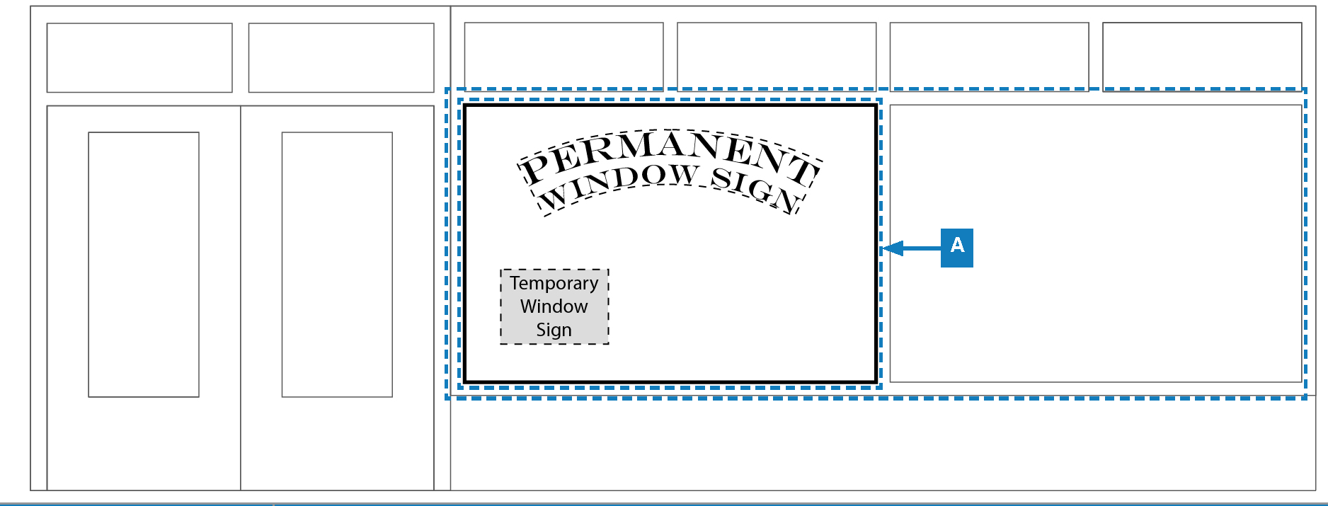
Signs Allowed Without a Sign Permit. Window signs are allowed without a sign permit consistent with the standards in this subsection. See Section 18.88.040 (Signs Allowed Without Permits) for all sign types that do not require a permit.
4.
Prohibited Signs. All signs prohibited in Section 18.88.050 (Prohibited Signs) are prohibited in the form-based zoning districts with the exception of painted wall signs, which are permitted in all form-based zoning districts.
5.
General Sign Standards. Standards for each allowed permanent sign type are provided in tables with a supporting illustration of each sign type. All permanent signs must comply with the standards for sign area, height, number, type, and other requirements provided in these tables.
a.
Sign Area for Permanent Building-Mounted Signs
(i)
Aggregate sign area of all building-mounted signs shall be limited to a maximum of 1.25 square feet per linear foot of building frontage along Monterey Road and a maximum of one square foot per linear foot of building frontage along other streets.
(ii)
See Section 18.88.080.B.3 (Sites with Multiple Frontages) for sign standards regarding buildings with more than one frontage on a public street, excluding alleys.
b.
Monument Signs. See Table 18.29-8 (Monument Signs) for free-standing sign standards.
c.
Font Types per Sign. Signs shall be limited to a maximum of two letter styles or font types.
d.
Illumination
(i)
Signs may be internally or externally illuminated except where specifically prohibited. Internal illumination is permitted only when the portion of the sign that appears illuminated is primarily the sign text, registered trademark, or logo.
(ii)
The light source for externally illuminated signs must be arranged and shielded to substantially confine all direct light rays onto the sign face and away from streets and adjacent properties.
e.
Materials and Design
(i)
Except for interior window signs, all permanent signs shall be constructed of wood, metal, plastic, glass, or similar durable and weatherproof materials.
(ii)
The size of letters and graphics shall be proportional to the overall sign area.
(iii)
Signs shall employ the use of simple and symmetrical sign shapes.
6.
Standards for Specific Sign Types. The sign standards in this Subsection supersede the standards in Section 18.88.100 (Standards for Specific Sign Types).
7.
Adjustments to Sign Standards. See Section 18.88.070 (Adjustment to Sign Standards).
8.
Master Sign Program. See Section 18.88.110 (Master Sign Program).
9.
Temporary Signs. See Section 18.88.120 (Temporary Signs).
10.
Nonconforming Signs. See Section 18.88.130 (Nonconforming Signs).
11.
Violations and Enforcement. See Section 18.88.140 (Violations and Enforcement).
Table 18.29-4 Awning Signs
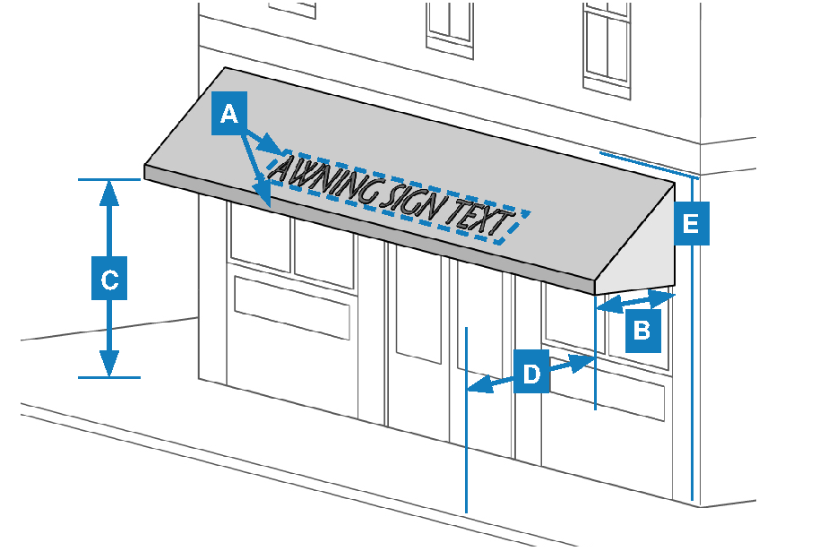
| Standards | Requirements | |
|---|---|---|
| Sign Type | Awning | |
| Max. Area | 2/3 of awning valance area and 15% of awning face, or 25 s.f. overall, whichever is less | |
| Max. Projection from Building Wall | 4 ft.; May project into public right-of-way with permit approval | |
| Min. Vertical Clearance | 8 ft. | |
| Min. Horizontal Clearance | 2 ft. from street or drive aisle curb | |
| Placement | May only be mounted on the wall area below the second floor | |
| Illumination | Illumination from below the awning or non-illuminated | |
| Materials | Plastic or vinyl material is not permitted | |
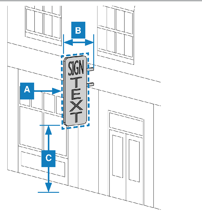
Table 18.29-5 Blade Signs
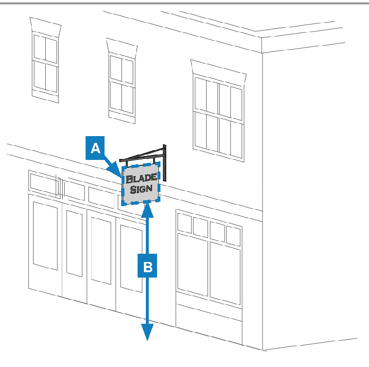
| Standards | Requirements | |
|---|---|---|
| Sign Type | Blade | |
| Max. Number | 1 per tenant space | |
| Max. Area | 12 s.f. | |
| Min. Vertical Clearance | 8 ft. | |
| Projection | May project into public right-of-way with permit approval | |
| Placement | If mounted below the underside of a walkway or overhead structure, must not extend beyond the edge of the structure on which it is located; Must be mounted perpendicular to the building face or corner of the building | |
| Illumination | Internal or external illumination | |
Table 18.29-6 Canopy Signs
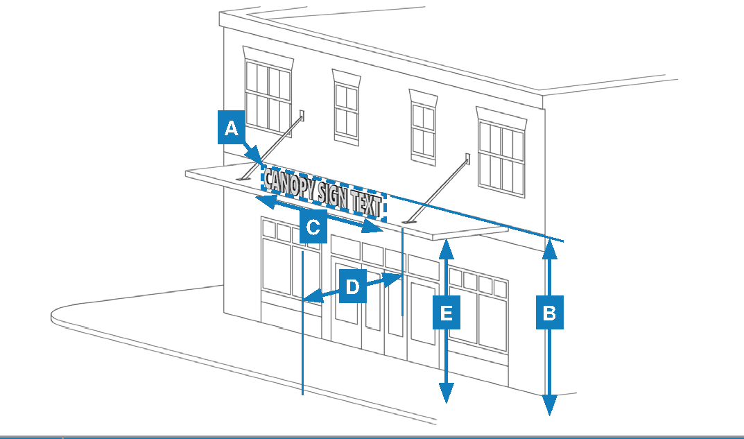
| Standards | Requirements | |
|---|---|---|
| Sign Type | Canopy | |
| Max. Number | 1 per tenant space | |
| Max. Area | 1 s.f. per linear foot of canopy width | |
| Max. Height | 20 ft. | |
| Max. Width | No greater than 60% of the width of the canopy on which it is displayed | |
| Min. Horizontal Clearance | 2 ft. from street or drive aisle curb | |
| Min. Vertical Clearance | 8 ft. | |
| Projection | May project into public right-of-way with permit approval | |
| Placement | Must be placed above the doors and windows of the ground floor of a building | |
| Illumination | Internal illumination | |
Table 18.29-7 Marquee Signs
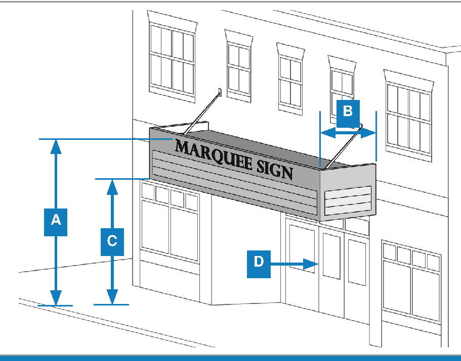
| Standards | Requirements | |
|---|---|---|
| Sign Type | Marquee | |
| Max. Number | 1 per building | |
| Max. Height | 35 ft. | |
| Use Restrictions | Limited to theaters, auditoriums, and indoor amusement/entertainment facilities | |
| Max. Projection from Building Wall | 12 ft.; May project into public right-of-way with permit approval | |
| Min. Vertical Clearance | 8 ft. | |
| Placement | Shall be affixed to a building wall directly above the primary public entrance of the use | |
| Illumination | Internal, direct illumination, or chase lights only | |
Table 18.29-8 Monument Signs
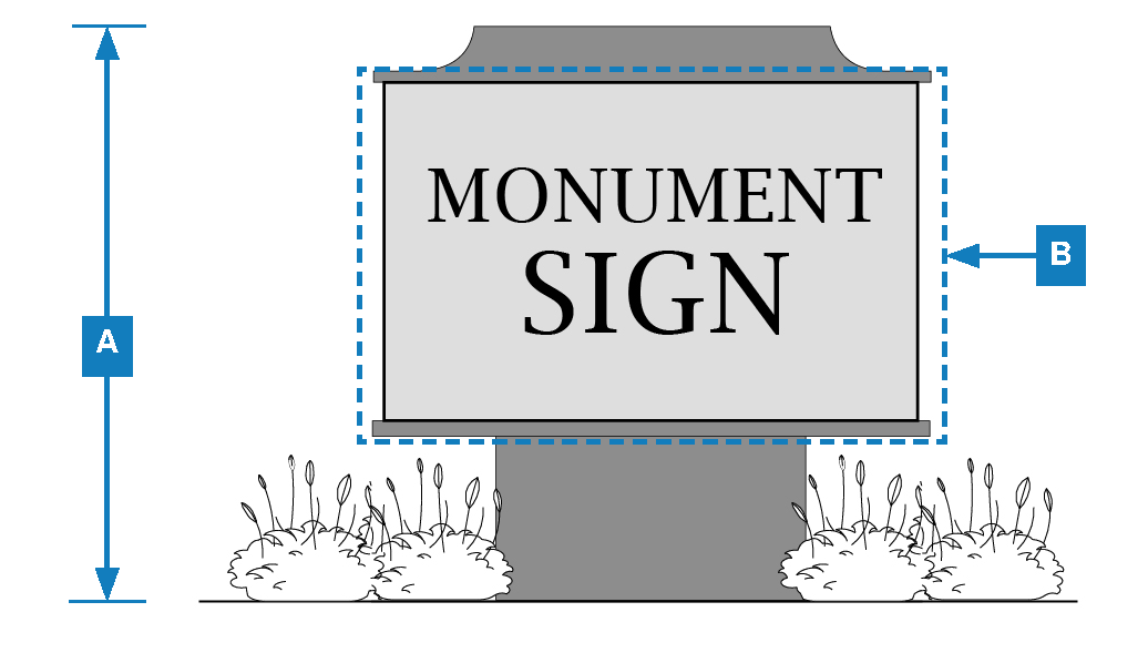
| Standards | Requirements | |
|---|---|---|
| Sign Type | Monument | |
| Max. Number | 1 per street frontage or 1 per vehicle access point from street | |
| Max. Height | 8 ft. | |
| Max. Area | 0.5 s.f. per linear foot of property street frontage up to 50 s.f. | |
| Max. Base Width | The monument sign's base must be at least 60% of the width of the sign. | |
| Setbacks | 6 ft. min. from vehicle access ways and 3 ft. min. from property lines | |
| Illumination | Internal or external illumination | |
| Min. Separation | Shall be separated a min. of 75 ft. from monument signs on abutting properties and 100 ft. from monument signs on the same property | |
| Landscaping | Base area shall be located in an irrigated landscaped planting area | |
Table 18.29-9 Projecting Signs
| Standards | Requirements | |
|---|---|---|
| Sign Type | Projecting | |
| Max. Number | 1 per tenant space | |
| Max. Area | 24 s.f. | |
| Max. Projection from Building Wall | 6 ft.; May project into public right-of-way with permit approval | |
| Min. Vertical Clearance | 8 ft. | |
| Min. Horizontal Clearance | 2 ft. from street or drive aisle curb | |
| Landscaping | Internal illumination | |
Table 18.29-10 Suspended Signs
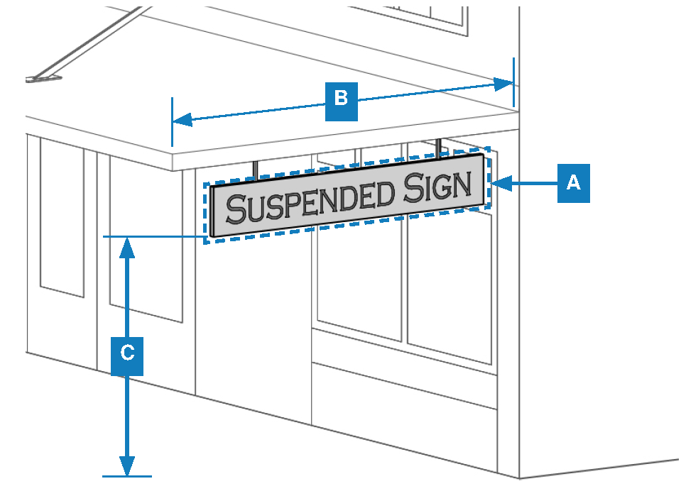
| Standards | Requirements | |
|---|---|---|
| Sign Type | Suspended | |
| Max. Number | 1 per tenant space | |
| Max. Area | 5 s.f. | |
| Max. Projection from Building Wall | No greater than the structure to which it is attached; May project into public right-of-way with permit approval | |
| Min. Horizontal Clearance | 2 ft. from street or drive aisle curb | |
| Min. Vertical Clearance | 8 ft. | |
| Illumination | Internal or external illumination | |
| Placement | Shall be suspended below a ground-level awning, canopy, or ceiling of an arcade | |
Table 18.29-11 Wall Signs
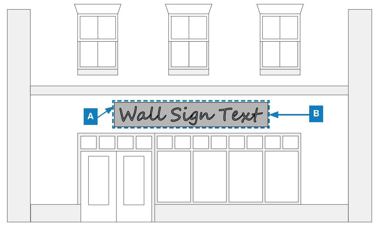
| Standards | Requirements | |
|---|---|---|
| Sign Type | Wall | |
| Max. Number | 1 per building frontage for single-tenant buildings and 1 per tenant space for multi-tenant buildings | |
| Max. Height | Not to exceed the top of the parapet of the building wall to which it is attached | |
| Max. Area | See Subsection 18.29.040.F.5.a | |
| Max. Projection from Building Wall | 10 in. | |
| Illumination | Internal or external illumination | |
| Placement | Shall be attached to the building wall of the use associated with the sign; for multi-tenant buildings, shall be affixed to the portion of the wall where the business is located | |
Table 18.29-12 Window Signs
| Standards | Requirements | |
|---|---|---|
| Sign Type | Window | |
| Max. Area of Permanent Sign | 25% of window to which it is attached; Painted window signs and perforated vinyl signs are included in the 25% calculation | |
| Illumination | Non-illuminated, neon, or single- or two-color LED | |
| Placement | Permitted on windows on the ground floor and second story only | |
(Ord. No. 2348, N.S., § 3(Exh. B), 9-6-2023)
18.29.090 - Permits and Administration for Form-Based Zoning Districts
A.
Administrative Responsibility. For all provisions related to administrative responsibility, see Chapter 18.100 (Administrative Responsibility).
B.
Common Permit Requirements. For all common permit requirements, see Chapter 18.104 (Common Permit Requirements).
C.
Specific Permit Requirements. For all common permit requirements, see Chapter 18.108 (Specific Permit Requirements).
D.
Sign Permit Requirements. For all sign permit requirements, see Section 18.88.030 (Required Permits) of Chapter 18.88 (Signs).
E.
Appeals. For all procedures related to appeals, see Chapter 18.112 (Appeals).
F.
Zoning Code Amendments. For all procedures related to Zoning Code Amendments, see Chapter 18.114 (Zoning Code Amendments).
G.
Development Agreements. For all procedures related to Development Agreements, see Chapter 18.116 (Development Agreements).
H.
Reasonable Accommodations. For all procedures related to reasonable accommodations, see Chapter 18.118 (Reasonable Accommodations).
I.
Enforcement. For procedures enforcement, see Chapter 18.120 (Enforcement).
18.29.100 - Definitions for Form-Based Zoning Districts
A.
"A" Terms
1.
Active Ground Floor. A street frontage that allows for active visual engagement between the people outside of a structure and the use, activities, or people, located in the structure's ground floor. In an active ground floor, the front facade of buildings and the main entrance face and open towards the right-of-way along which pedestrian access is provided.
2.
Affordable Units. Units that are made available for rent at a price below the Fair Market Rent value, as recorded and updated from time to time by the city based on the U.S. Department of Housing and Urban Development data.
3.
Architectural Feature. An architectural element, which alone or as part of a pattern, embodies the style, design, or general arrangement of the exterior of a building or structure, including, but not limited to, the kind, color, and texture of building materials, and style and type of windows, doors, lights, porches, and signs.
B.
"B" Terms
1.
Block Face. The aggregate of all the building facades on one side of a block. The block face provides the context for establishing the architectural form of the edge of the block.
2.
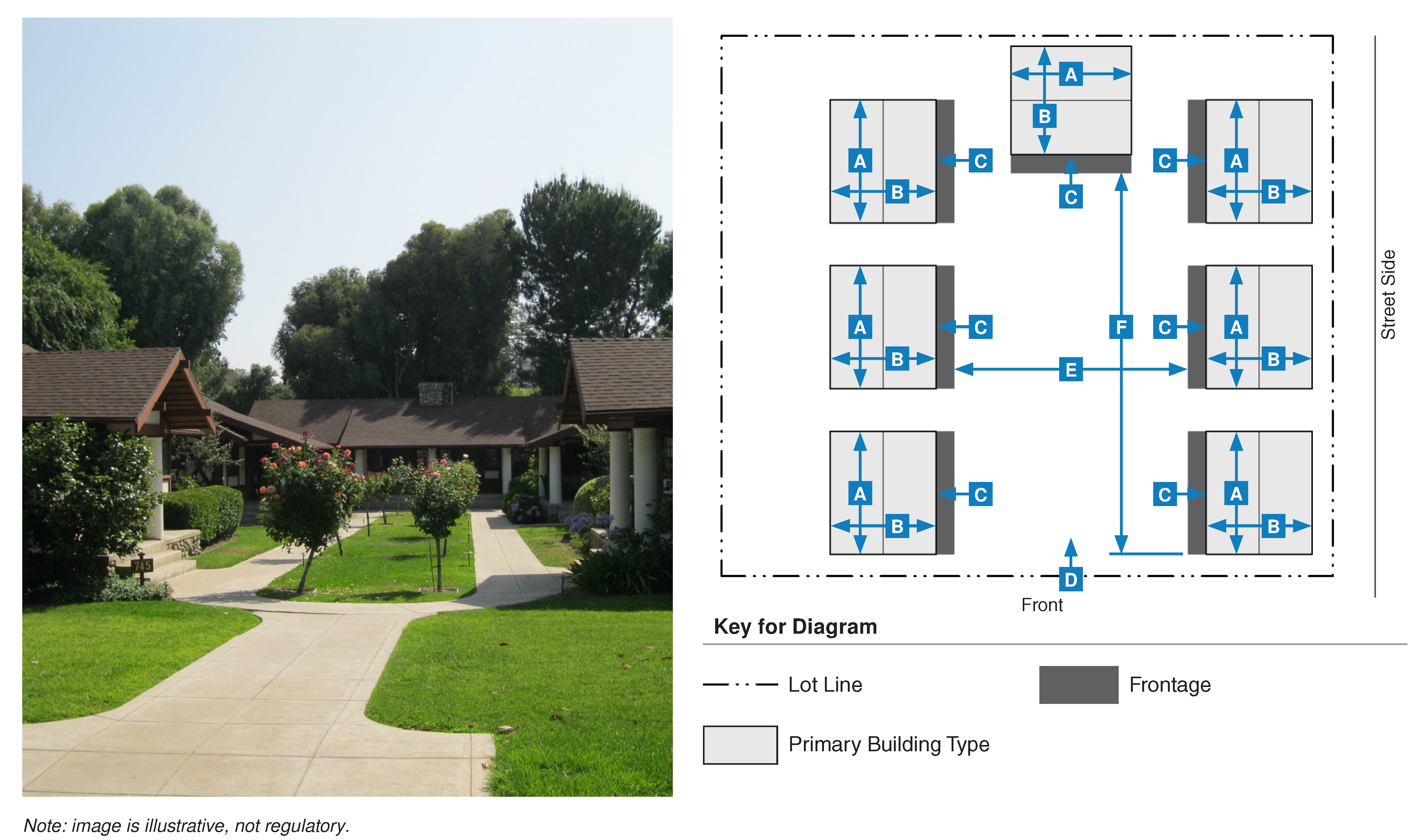
Bungalow Court. A group of detached buildings (ranging from three to nine separate units) arranged to define a shared courtyard that is generally perpendicular to the street. The shared courtyard is common open space and replaces the need for private rear yards. This type is scaled to fit within low and medium intensity walkable neighborhoods.
3.
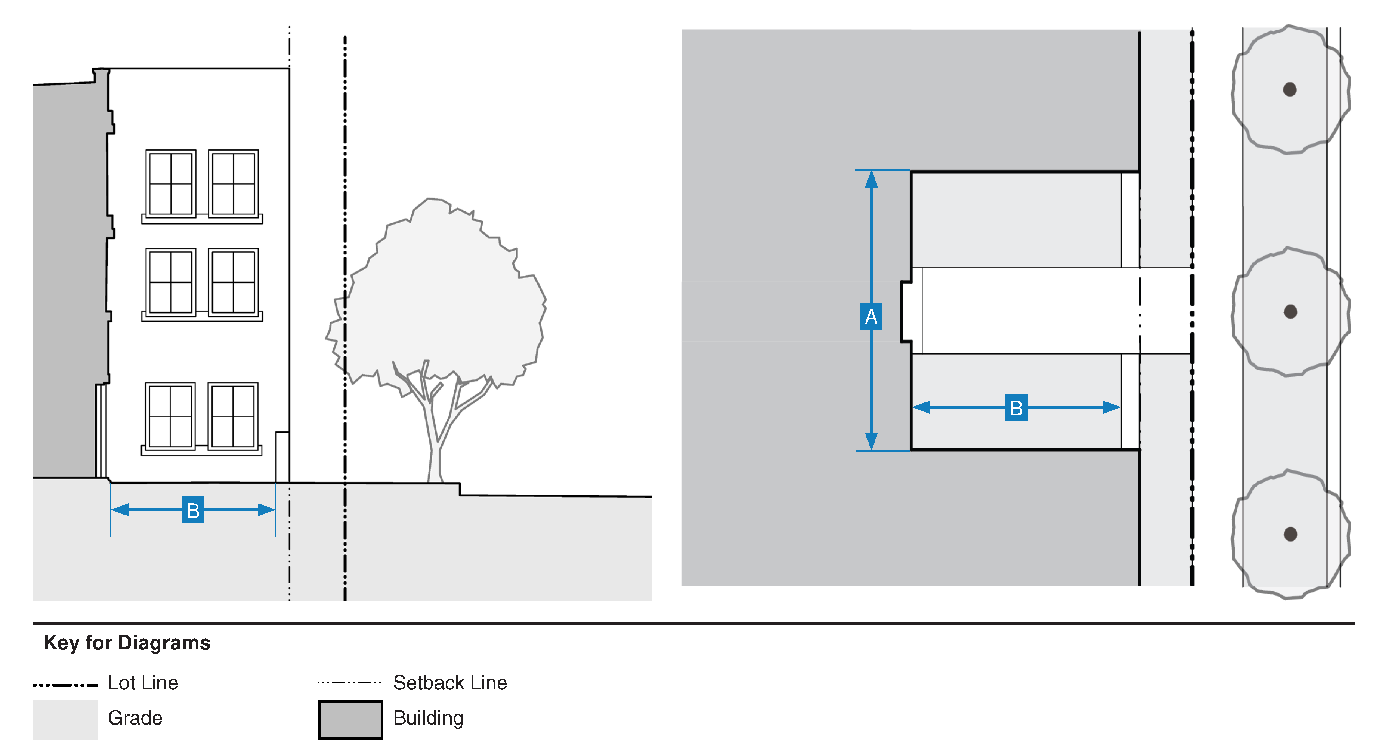
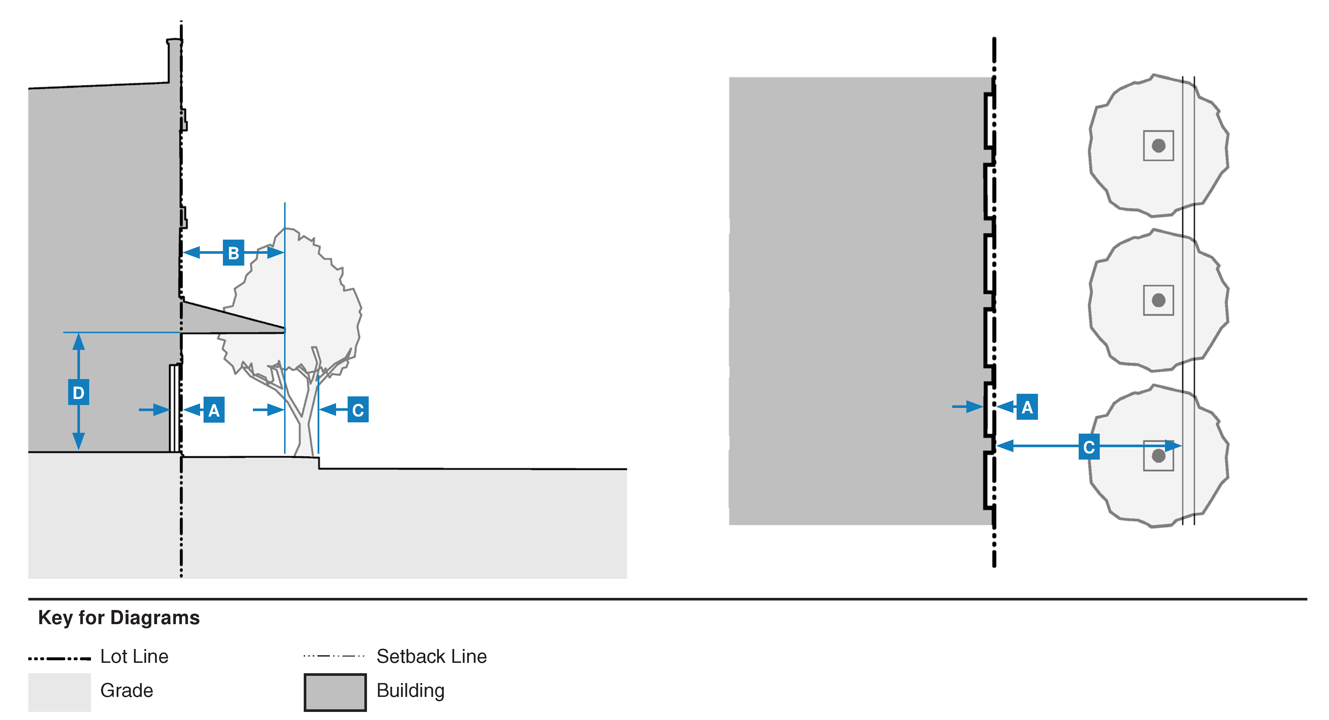
Build-to-Zone. The linear street frontage between the minimum and maximum setback lines along the front of a parcel and along the side street of a corner parcel in which a building must occupy for the established percentage of the street frontage.
Figure 18.29-2 Build-to-Zone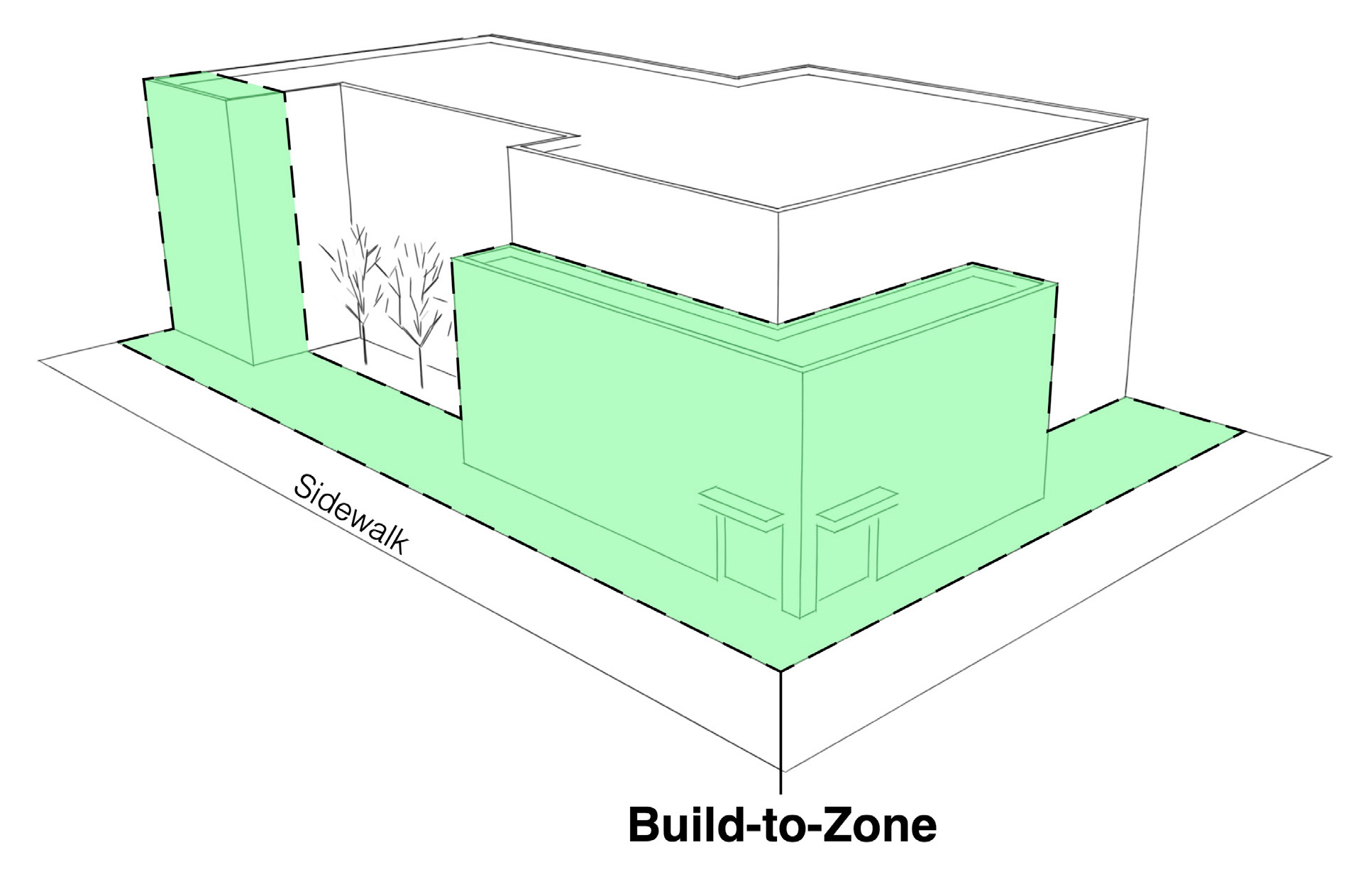
4.
Building Entrance. The place of pedestrian ingress and egress to a building most frequently used by the public.
5.
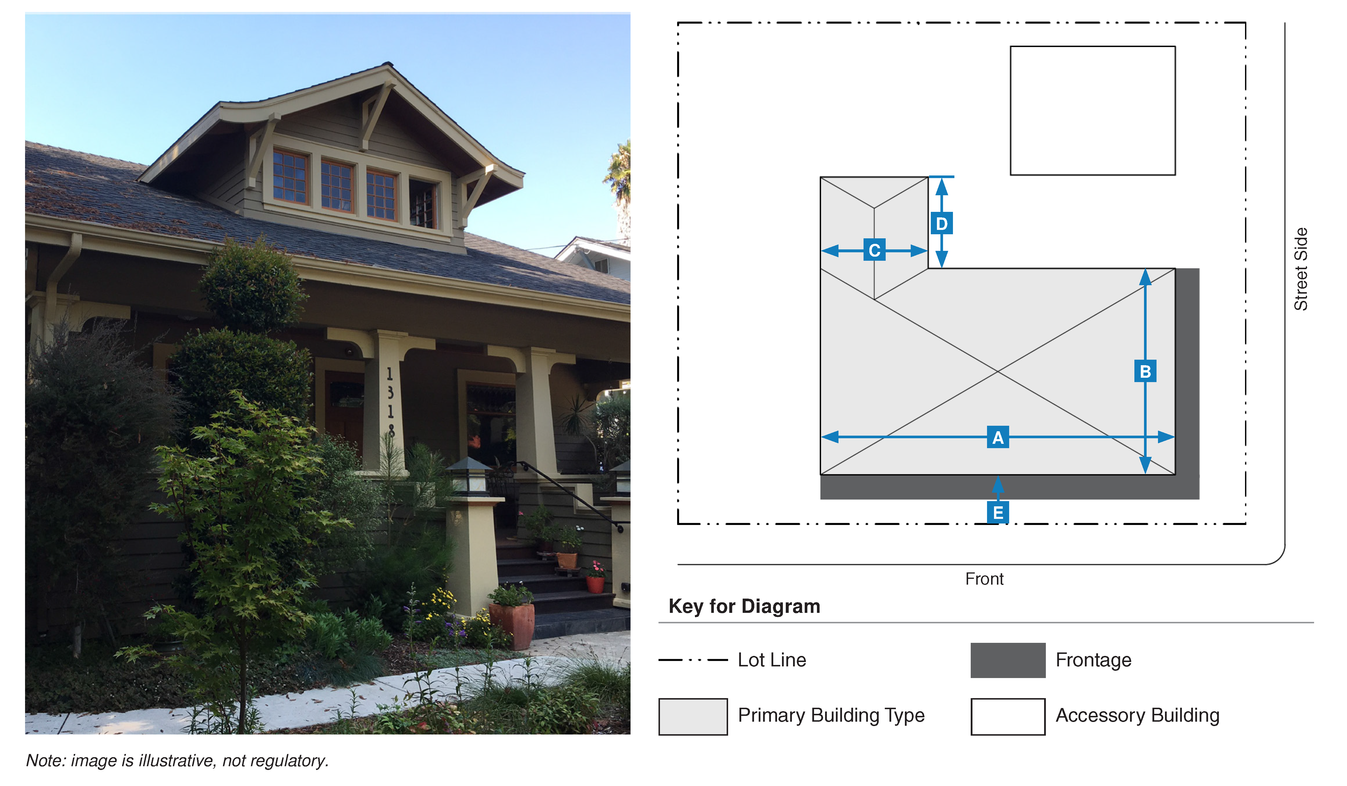
Building Form. The overall shape and dimensions of a building.
6.
Building, Main Body. The primary massing of a building.
7.
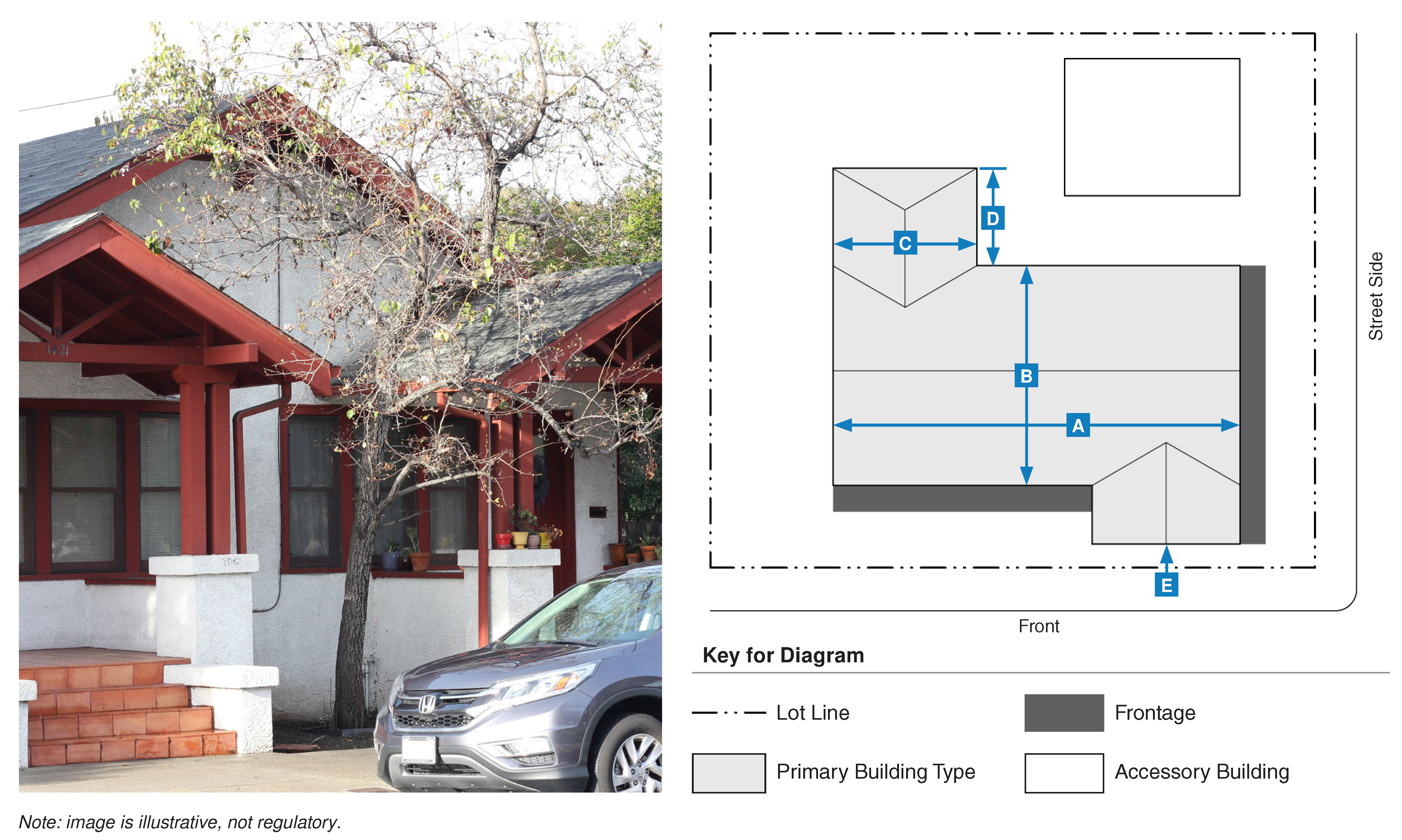
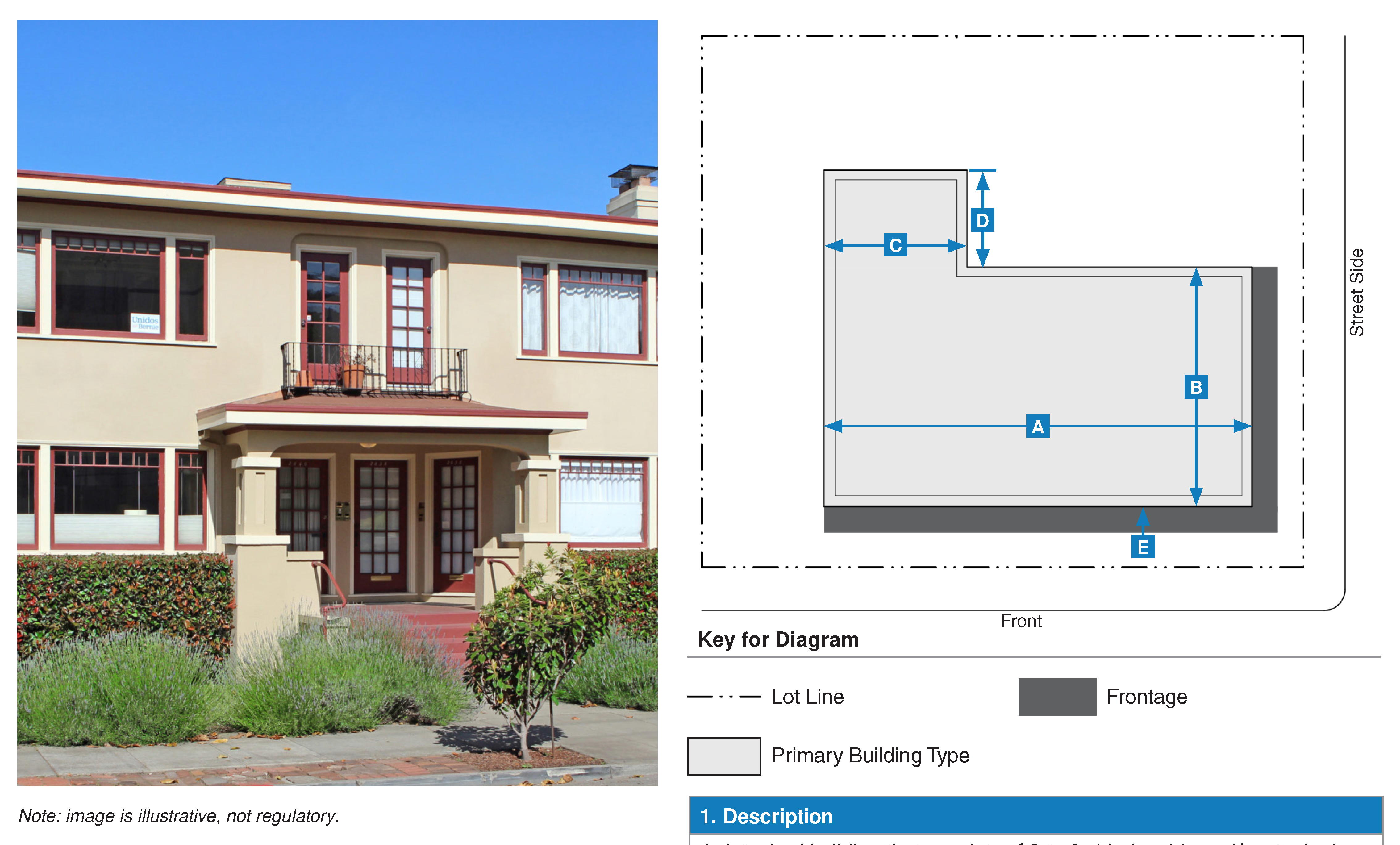
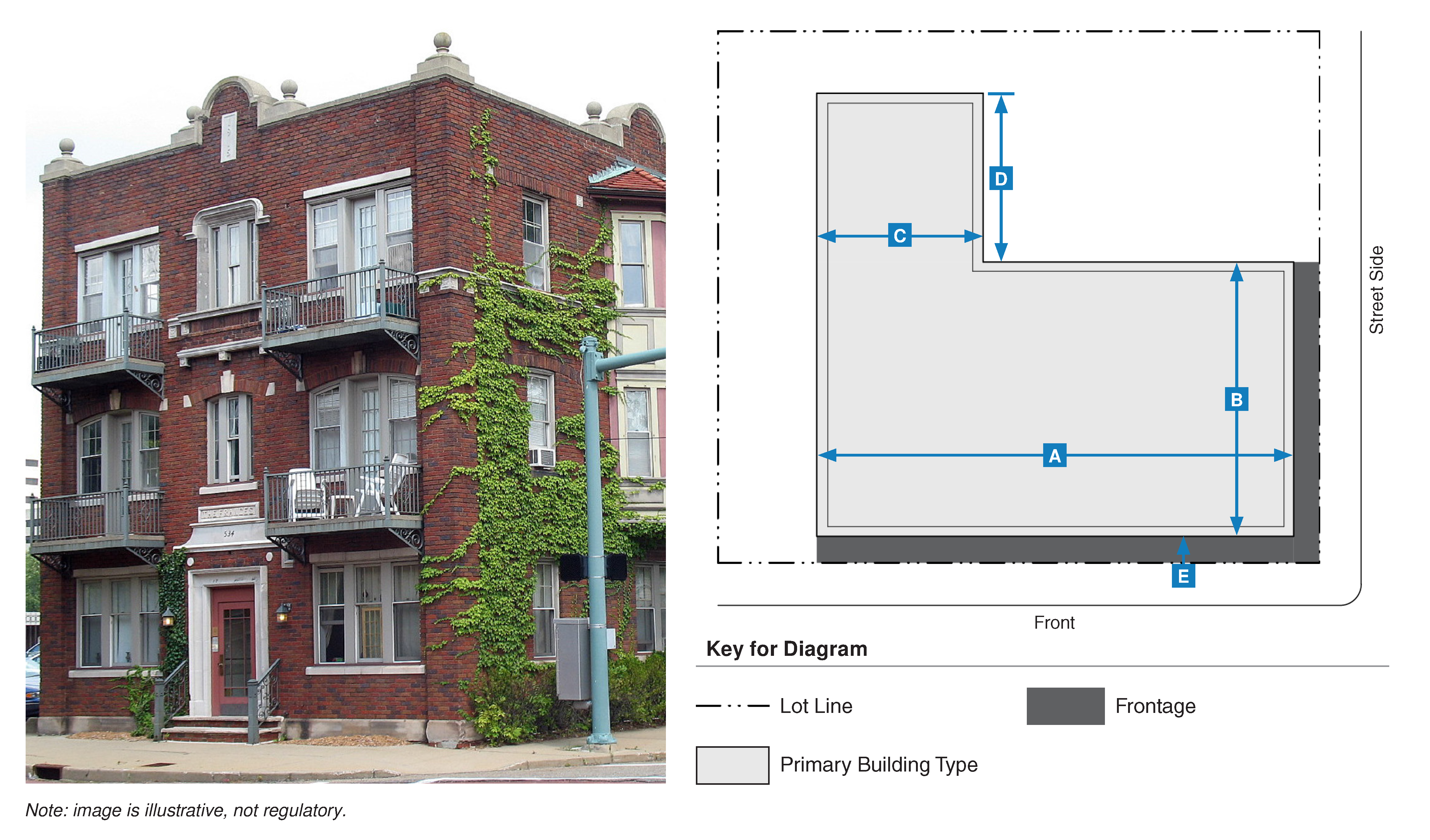
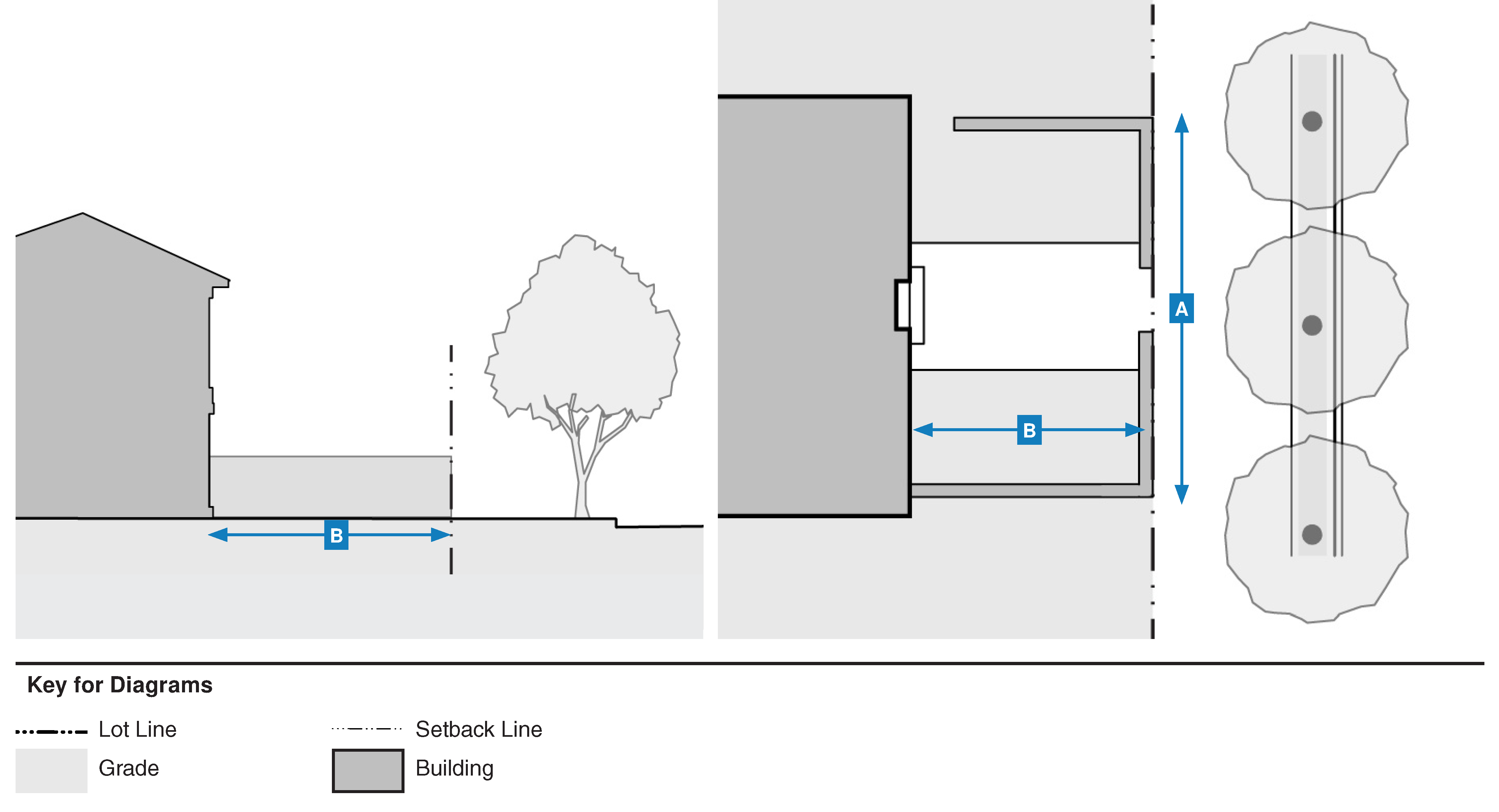
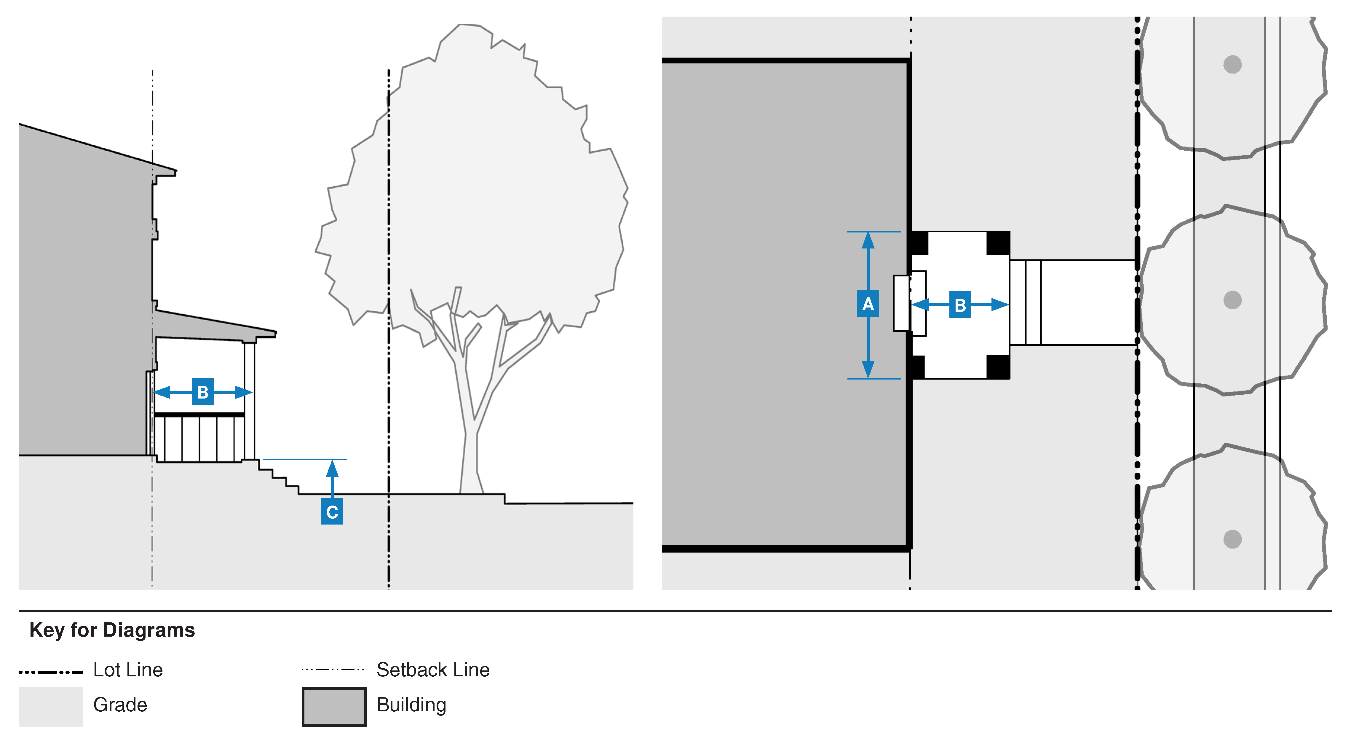
Building, Secondary Wing. A part of a building or structure that is physically attached to the building or structure, but is secondary and incidental in terms of form and massing.
Figure 18.29-3 Secondary Wing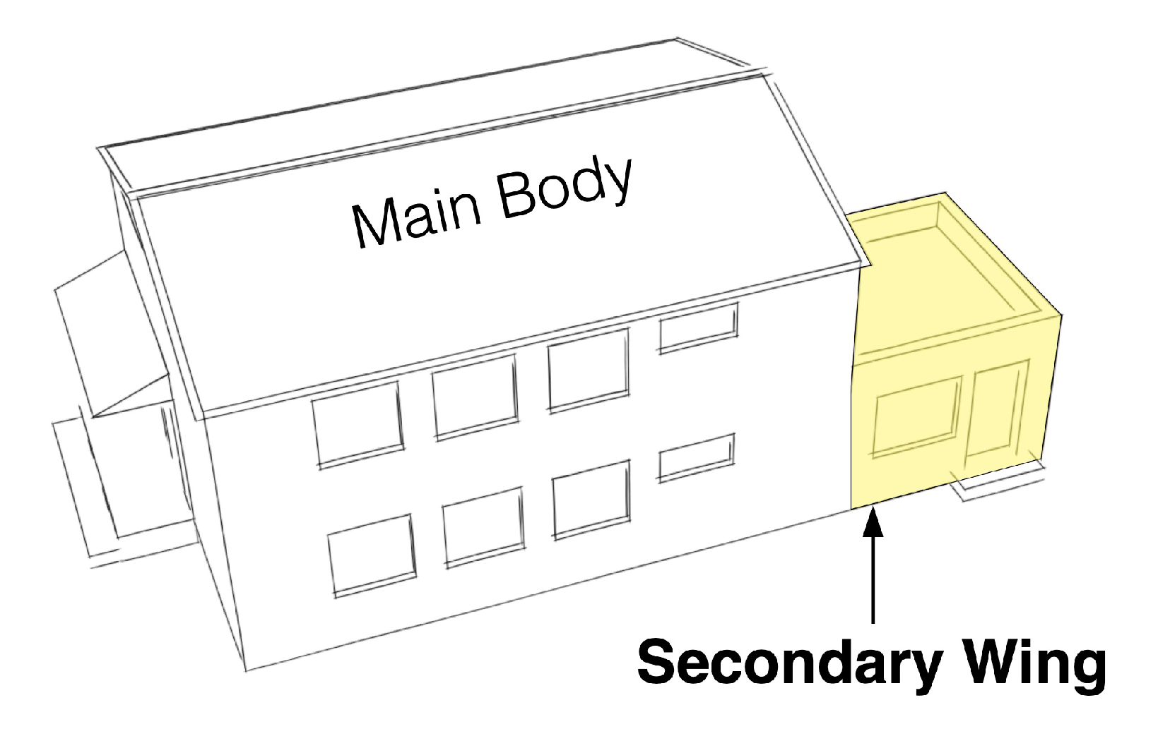
8.
Building Type. A structure defined by a combination of its configuration, placement on a lot, and function.
C.
"C" Terms
1.
Ceiling Height, Ground Floor. The height from the finished floor to the finished ceiling of primary rooms on the ground floor, not including secondary rooms such as bathrooms, closets, utility rooms, and storage spaces.
2.
Civic. A term defining not-for-profit organizations that are dedicated to arts, culture, education, recreation, government, transit, and public parking facilities.
3.
Corner Entry. A pedestrian entrance located on the corner of a building.
4.
Courtyard. An unroofed area that is completely or partially enclosed by walls or buildings and often shared by multiple residential units or commercial spaces.
5.
Courtyard Building. A building comprised of multiple attached and/or stacked units, accessed from one or more shared courtyards. The shared courtyard is common open space and replaces the need for private rear yards. This type is often integrated into medium and high intensity walkable neighborhoods and can be applied in non-residential contexts.
6.
Covered Parking. A portion of a parking area in which a shade structure(s) has been installed to provide shade for parked vehicles.
D.
"D" Terms
1.
Depth, Ground Floor Space. The distance from the street-facing facade to the rear interior wall of the ground-floor space available for a permitted use.
2.
Development Services Director. The development services director of the City of Morgan Hill or their designee, including community development director. The development services director is appointed by the city manager.
3.
Direct Illumination. Illumination resulting from light emitted directly from a bulb or light fixture, and not light diffused through translucent signs or reflected from other surfaces such as the ground or building face.
4.
Distance Between Entries. The horizontal distance measured parallel to the facade between entrances to a building or buildings.
5.
Duplex/Duet. A detached building consisting of two side-by-side or stacked units with shallow setbacks. For side-by-side units, both face the street with separate entrances; for stacked units, both are accessible via a single entrance or separate entrances that face the street. This type has the appearance of a house and is scaled to fit within low and medium intensity walkable neighborhoods.
E.
"E" Terms
1.
Entry. An opening, such as a door, passage, or gate, that allows access to a building.
F.
"F" Terms
1.
Facade, Primary. The exterior wall of a building facing a primary street.
2.
Facade, Secondary. The exterior wall of a building facing a secondary street or side street.
3.
Finish Level, Ground Floor. The height difference between the finished floor on the ground floor and the adjacent public sidewalk.
4.
Footprint. The outline of the area of ground covered by the foundations of a building or structure.
5.
Forecourt. The main facade of the building is at or near the right-of-way and a portion (usually the central portion) is set back, creating a courtyard space. The space may be used as an entry court, shared garden area, or additional shopping or restaurant seating area.
6.
Frontage. A strip of land abutting a thoroughfare, civic space, or other public right-of-way.
a.
Frontage Private. The area between the building facade and the shared lot line between the public right-of-way and the lot.
b.
Frontage Public. The area between the curb of the vehicular lanes and the edge of the right-of-way.
7.
Frontage Line. The lot line(s) of a lot fronting a thoroughfare or other public way, or a civic space.
8.
Front Yard. The main facade of the building has a large, landscaped area between the building and the right-of-way providing a separation from the street. The front yard is visually continuous with adjacent yards and supports a landscape in conjunction with other private frontages.
G.
"G" Terms
1.
Ground Floor. The floor of a building located nearest to the level of the ground around the building.
H.
"H" Terms
1.
House. A detached building with one dwelling unit, shallow setbacks, a rear yard, and located within a low intensity walkable neighborhood.
I.
"I" Terms
1.
Illumination, External. Illumination resulting from the face of the sign reflecting light from an external light source intentionally directed upon it.
2.
Illumination, Internal. A form of sign illumination that includes cabinet signs, single-color LED signs, signs constructed with pan channel letters, or indirect halo illuminated channel letters on an unlit or otherwise indistinguishable background on a freestanding sign or building wall.
J.
"J" Terms
No specialized terms beginning with the letter "J" are currently defined.
K.
"K" Terms
No specialized terms beginning with the letter "K" are currently defined.
L.
"L" Terms
1.
LED (Light Emitting Diode). A semiconductor diode that emits light when a voltage is applied to it.
2.
Light Fixture. A complete lighting assembly (including the lamp, housing, reflectors, lenses, and shields), less the support assembly (pole or mounting bracket). Includes luminous tubes, lamps or similar devices that are permanently installed or portable and used for illumination, decoration, or advertisement.
3.
Light Fixture, Fully Shielded. A light fixture or luminous tube constructed and mounted such that all light emitted by the fixture or tube, either directly from the lamp, tube, or a diffusing element, or indirectly by reflection or refraction from any part of the light fixture, is projected below a horizontal plane. If the lamp or tube, any reflective surface, or lens cover (clear or prismatic) is visible when viewed from above or directly from the side, from any angle around the fixture or tube, the fixture or tube is not fully shielded. To be fully shielded these fixtures must be closed on top and mounted so that the bottom opening is horizontal.
4.
Light Fixture, Unshielded. A light fixture that is not fully shielded or partially shielded. Even though the lamp in these fixtures is shielded from direct view when viewed from the side or above, reflective surfaces and/or lens covers are directly visible from the side.
5.
Liner Building. An attached building with two main components: an interior building and an exterior building to conceal the interior building from the street on the front and street side. The interior building is usually a parking structure or large retail/entertainment space and the exterior building is intended for retail, service, office, or residential space. This type is a component of main street building form.
M.
"M" Terms.
1.
Main Street Building. An attached building intended to provide a vertical mix of uses with ground floor retail, office, or service uses with individual entries, and upper floor office, service, or residential uses with one or more shared entries. This type is the primary component of main street building form.
2.
Multiplex Large. A detached building that consists of seven to twelve side-by-side and/or stacked units, with one shared entry. This type is scaled to fit within medium intensity walkable neighborhoods.
3.
Multiplex Small. A detached building that consists of three to six side-by-side and/or stacked units, with one shared entry or individual entries along the front. This type has the appearance of a house and is scaled to fit within low and medium intensity walkable neighborhoods.
N.
"N" Terms.
No specialized terms beginning with the letter "N" are currently defined.
O.
"O" Terms.
1.
Open Space, Common. A portion of a site that is designated and intended for the use or enjoyment of the residents or owners of the development and/or the overall community. Common open space may contain such complementary structures and improvements as are necessary and appropriate for the benefit and enjoyment of the individuals using the space.
2.
Open Space, Private. A usable open space adjoining and directly accessible to a dwelling unit, reserved for the exclusive use of residents of the dwelling unit and their guests.
P.
"P" Terms.
1.
Parking Driveway Width. The horizontal measurement of an access driveway to a parking area, measured perpendicular to the direction of travel.
2.
Passage. An informal or formal gathering space that serves as a pedestrian connector between other gathering places, streets, and/or parking areas. Passages are usually hardscaped and located near the middle of a block, providing a pedestrian connection through a block. Passages may be linear or L-shaped. Passages provide additional frontage opportunities for retail and/or residential uses along edges.
3.
Pocket Park/Plaza. A small-scale landscaped or hardscaped open space designed to provide opportunities for neighborhood gathering and/or passive recreation, generally for those who live within walking distance. Pocket parks/plazas are accessible from the public right-of-way, but clearly delineated as a separate space.
4.
Plaza. A space available for civic purposes and commercial activities intended to add to the activity and vibrancy of streets and neighborhoods. Plazas are formal spaces with interior green spaces and defined edges made primarily of hardscape materials.
5.
Porch, Engaged. The main facade of the building is setback from the right-of-way and a porch is attached providing access to the building. The porch provides necessary physical separation for the private lot from the public right-of-way. The engaged porch has two adjacent sides attached to the building while the other two sides are open.
6.
Porch, Projecting. The main facade of the building is setback from the right-of-way and a porch is attached providing access to the building. The porch provides necessary physical separation for the private lot from the public right-of-way. The projecting porch is open on three sides and projects in front of the primary building wall.
7.
Projection. Any architectural feature, structure, or structural element, such as an gallery, fence, garden wall, porch, stoop, balcony, bay window, or terrace, that breaks the plane of a horizontal regulatory limit extending into the facade zone or a setback.
8.
Public Realm. The physical and social domain of the public that is held in common either by their physical presence or by visual association. This includes, but is not limited to plazas, squares, parks, thoroughfares, public frontages, private frontages, civic buildings, and civic spaces.
Q.
"Q" Terms.
No specialized terms beginning with the letter "Q" are currently defined.
R.
"R" Terms.
1.
Recessed Entry. An entrance to a building that is set back from the facade of the building.
2.
Recreation, Active. Recreational pursuits usually performed with others and often requiring equipment which require physical alteration to the area in which they are performed. Such areas are intensively used, and include but are not limited to playgrounds, sport courts, baseball/softball and other field sports, and swimming pools.
3.
Recreation, Passive. Recreational pursuits involving existing natural resources which can be carried out with little alteration or disruption to the area in which they are performed. This includes, but is not limited to, such activities as walking, hiking, bicycling, bird and animal watching, and picnicking.
4.
Regulating Plan. The map of an area designating the locations of form-based zoning districts. A regulating plan may be incorporated into the city's official zoning map.
5.
Right-of-Way. A strip of land acquired by reservation, dedication, forced dedication, prescription, or condemnation for public use for pedestrian and vehicular movement occupied by a road, crosswalk, railroad, electric transmission lines, oil or gas pipeline, water line, sanitary storm sewer or other public utility or facility.
S.
"S" Terms.
1.
Shopfront. The main facade of the building is placed at or near the right-of-way with an at-grade entrance along the sidewalk. The shopfront is generally intended for retail or service uses and has substantial glazing at the ground floor level.
2.
Sidewalk. The portion of a right-of-way that is paved and intended exclusively for pedestrian use, and often installed between the curb and adjacent property lines.
3.
Sign, Awning. A roof or cover that projects from the wall of a building over a door or window, and made of canvas, aluminum or a similar material, which may be fixed in place or retractable for the purpose of shielding a doorway or window from the elements.
4.
Sign, Blade. A permanent sign mounted either to the wall of a building by means of a bracket or attached to the underside of the lintel, arch, or other overhead structure above a porch or walkway and which is typically hung perpendicular to the wall of the building.
5.
Sign, Canopy. A sign painted on, printed on, or otherwise attached flat against the surface of a canopy.
6.
Sign, Marquee. A permanent sign structure placed over the entrance to a building and typically used for a theater or other entertainment use.
7.
Sign, Monument. A permanent, freestanding sign with a solid base that is at least sixty percent the width of the sign face.
8.
Sign, Projecting. A permanent sign that is attached to and extends perpendicular from the wall of a building.
9.
Sign, Suspended. A permanent sign attached to or suspended from the underside of an arcade, canopy, or marquee and oriented to pedestrian traffic.
10.
Sign, Wall. A permanent sign affixed to or erected against the wall or fascia of a building or structure, with the exposed face of the sign parallel to the plane of the wall or fascia to which it is affixed or erected.
11.
Sign, Window. A permanent or temporary sign posted, painted, placed, or affixed in or on a window, or otherwise exposed to public view through a window.
12.
Stoop. The main facade of the building is near the right-of-way and the stoop engages the sidewalk. The stoop is elevated above the sidewalk to ensure privacy within the building. The entrance is usually an exterior stair and landing.
13.
Street Frontage. See the definition for "Frontage Line."
T.
"T" Terms.
1.
Tandem Parking. A parking space deep enough to allow two cars to park one behind the other.
2.
Terrace. The main facade of the building has an elevated terrace that projects outward and engages the sidewalk with frequent stairs. The terrace allows at-grade access to all ground floor uses due to natural grade constraints or by artificially elevating the terrace floor. The terrace acts as a buffer from the sidewalk and may be landscaped to provide additional privacy. Building activities are slightly separated from the adjacent sidewalk by the terrace finish level, and the depth of the terrace provides space for outdoor seating, private yards, or any other appropriate uses.
3.
Townhouse. An attached building that consists of three to ten units placed side-by-side with individual entries along the front. This type has a rear yard and is located within medium and high intensity walkable neighborhoods, or on or near a neighborhood main street.
4.
Transparency. The area of a building frontage/facade that must contain transparent glass in order to improve building/tenant visibility and complement walkable environments.
U.
"U" Terms.
1.
Unit. A discrete portion of a building.
2.
Upper Floor. A floor in a building containing habitable space that is located above the ground floor.
V.
"V" Terms.
1.
Valance. The vertical front face of an awning, parallel to the face of the building to which it is mounted.
W.
"W" Terms.
1.
Walkway. A paved way located on one or more lots used for pedestrians and for the exclusive use of the lot owner(s), their guests, and invitees.
X.
"X" Terms.
No specialized terms beginning with the letter "X" are currently defined.
Y.
"Y" Terms.
No specialized terms beginning with the letter "Y" are currently defined.
Z.
"Z" Terms.
No specialized terms beginning with the letter "Z" are currently defined.
(Ord. No. 2348, N.S., § 3(Exh. B), 9-6-2023)