
Morgan Hill City Zoning Code
CHAPTER 18
12 - Rules of Measurement
18.12.010 - Purpose.
This chapter establishes rules for the measurement of standards contained in the zoning code.
(Ord. No. 2277 N.S., § 5(Exh. A), 6-6-2018)
18.12.020 - Building coverage.
A.
Building Coverage. Building coverage means the total horizontal area of all buildings on a lot divided by the net lot area. Total horizontal building area is measured from the exterior surface of the exterior ground floor walls of all principal and accessory buildings on the lot.
B.
Building Coverage (Exclusions). Building coverage does not include the following:
1.
Unenclosed and unroofed decks, uncovered patio slab, porches, landings, balconies and stairways less than eighteen inches in height at surface of deck (and less than six feet including railings). See Figure 18.12-1.
2.
Eaves and roof overhangs projecting less than two feet from a wall.
3.
Areas covered by a trellis or similar structure where at least fifty percent of the area is open to the sky with uniformly distributed openings.
4.
Swimming pools and hot tubs that are not enclosed in roofed structures or deck.
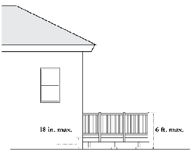
Figure 18.12-1: Deck Excluded from Building Coverage
(Ord. No. 2277 N.S., § 5(Exh. A), 6-6-2018)
18.12.030 - Density.
Density means the number of dwelling units divided by the net lot area.
(Ord. No. 2277 N.S., § 5(Exh. A), 6-6-2018)
18.12.040 - Distances.
A.
Measurements Are Shortest Distance. When measuring a required distance, such as the minimum distance between a structure and a lot line, the measurement is made at the closest or shortest distance between the two objects.
B.
Distances Are Measured Horizontally. When measuring distances for setbacks and structure dimensions, all distances are measured along a horizontal plane from the appropriate line, edge of building, structure, storage area, parking area, or other object. Distances are not measured following the topography or slope of the land.
C.
Measurements Involving a Structure. Measurements involving a structure are made to the closest support element of the structure. Structures or portions of structures that are entirely underground are not included in measuring required distances.
D.
Measuring Radius. When a specified land use is required to be located a minimum distance from another land use, the minimum distance is measured in a straight line from all points along the lot line of the subject project, in all directions.
(Ord. No. 2277 N.S., § 5(Exh. A), 6-6-2018)
18.12.050 - Floor area and floor area ratio.
A.
Floor Area.
1.
Floor area means the total enclosed area of all floors of a building measured from the outside face of the structural members in outside walls.
2.
The floor area calculation includes the following:
a.
Covered parking areas for residential uses, including detached garages.
b.
Staircases and elevator shafts at each floor level.
Service and mechanical equipment rooms.
c.
Areas with a solid roof even if open on the sides (e.g., covered porches, patios, and California rooms).
d.
For nonresidential uses, interior walkways or corridors, interior courtyards, walkways, paseos, or corridors covered by a roof or skylight.
3.
The floor area calculation does not include the following:
a.
Attic areas as defined in Section 18.128.020.A ("A" Terms).
b.
Covered parking areas for non-residential uses.
c.
Basement area as defined in Section 18.128.020.B ("B" Terms).
d.
Front-facing covered porches where at least fifty percent of the sides are open and exposed (without walls) to adjacent outdoor space.
e.
Areas covered by a trellis or similar structure where at least fifty percent of the area is open to the sky with uniformly distributed openings.
f.
Windows or other architectural projections where the vertical distance between the lowest surface of the projection and the finished floor is thirty inches or more.
g.
For nonresidential uses, arcades, porticoes, and similar open areas that are located at or near street level and are accessible to the general public but are not designed or used as sales, display, storage, service, or production areas.
B.
Floor Area Ratio. Floor area ratio means the ratio of the total floor area of all buildings on a lot to the net lot area.
(Ord. No. 2277 N.S., § 5(Exh. A), 6-6-2018)
18.12.060 - Height.
A.
Building Height. Building height means the vertical distance from the average contact ground level at the front wall of the building to the highest point of the building. See Figure 18.12-2.
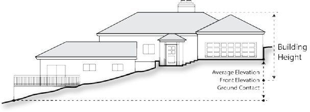
Figure 18.12-2: Building Height
B.
Number of Stories.
1.
Basements and Cellars. A basement or cellar shall not be included in the calculation of number of stories of a building if the finished surface of the floor above is six feet or less below the average level of the adjoining grade. See Figure 18.12-3.
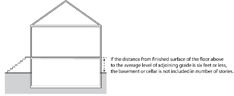
Figure 18.12-3 Number of Stories - Basement or Cellar Height
2.
Mezzanines. A mezzanine shall not be included in the calculation of number of stories if:
a.
The mezzanine floor area is one-third or less of the total area of the full floor directly below it; and
b.
The mezzanine is open on at least two sides to the full floor below.
C.
Fence or Wall Height.
1.
Fence or wall height means the vertical distance from the bottom to the top of the fence or wall.
2.
Fences placed on top of a retaining wall do not include the height of retaining wall.
3.
If the adjacent finished grade is different on opposite sides of a fence or wall, the height is measured from the side with the lowest finished grade to the highest point on the fence or wall.
D.
Freestanding Structure Height. For freestanding structures such as poles and towers, structure height means the vertical distance from the finished grade at the base of the structure to the highest point of the structure.
(Ord. No. 2277 N.S., § 5(Exh. A), 6-6-2018)
18.12.070 - Lot area and dimensions.
A.
Lot Area. Lot area means the net site area of a lot, expressed in terms of acres or square feet. Lot area does not include:
1.
Land within the limits of a street (public or private) upon which the lot abuts, even if fee title to such street is held by the owner.
2.
All public easements (e.g., public streets, utility lines).
3.
All private easements (e.g., private streets, accessways) other than streets which are in excess of fifteen percent of the net site area of the lot.
B.
Lot Depth.
1.
For lots other than flag lots, lot depth means the horizontal distance from the midpoint of the front lot line to the midpoint of the rear lot line, or to the most distant point on any other lot line where there is no rear lot line. See Figure 18.12-4.
2.
For flag lots, lot depth is measured as the distance of the shortest side property line.
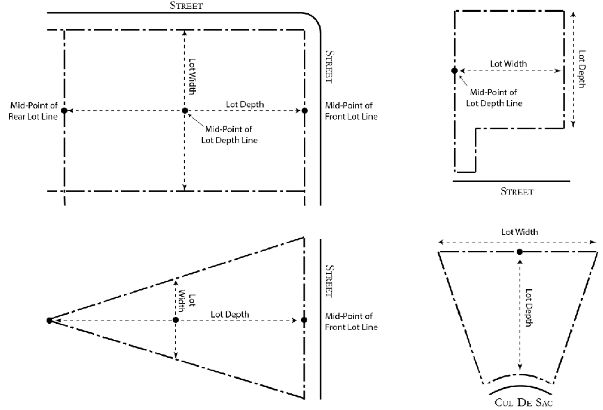
Figure 18.12-4: Lot Depth and Width
C.
Lot Width.
1.
For lots other than cul-de-sac lots, lot width means the distance measured along a straight line between the midpoints of the side property lines.
2.
For flag lots, the measurement of the midpoint of the side property lines excludes the narrow corridor providing access to the street.
3.
For cul-de-sac lots, lot width is measured at the rear property line.
(Ord. No. 2277 N.S., § 5(Exh. A), 6-6-2018)
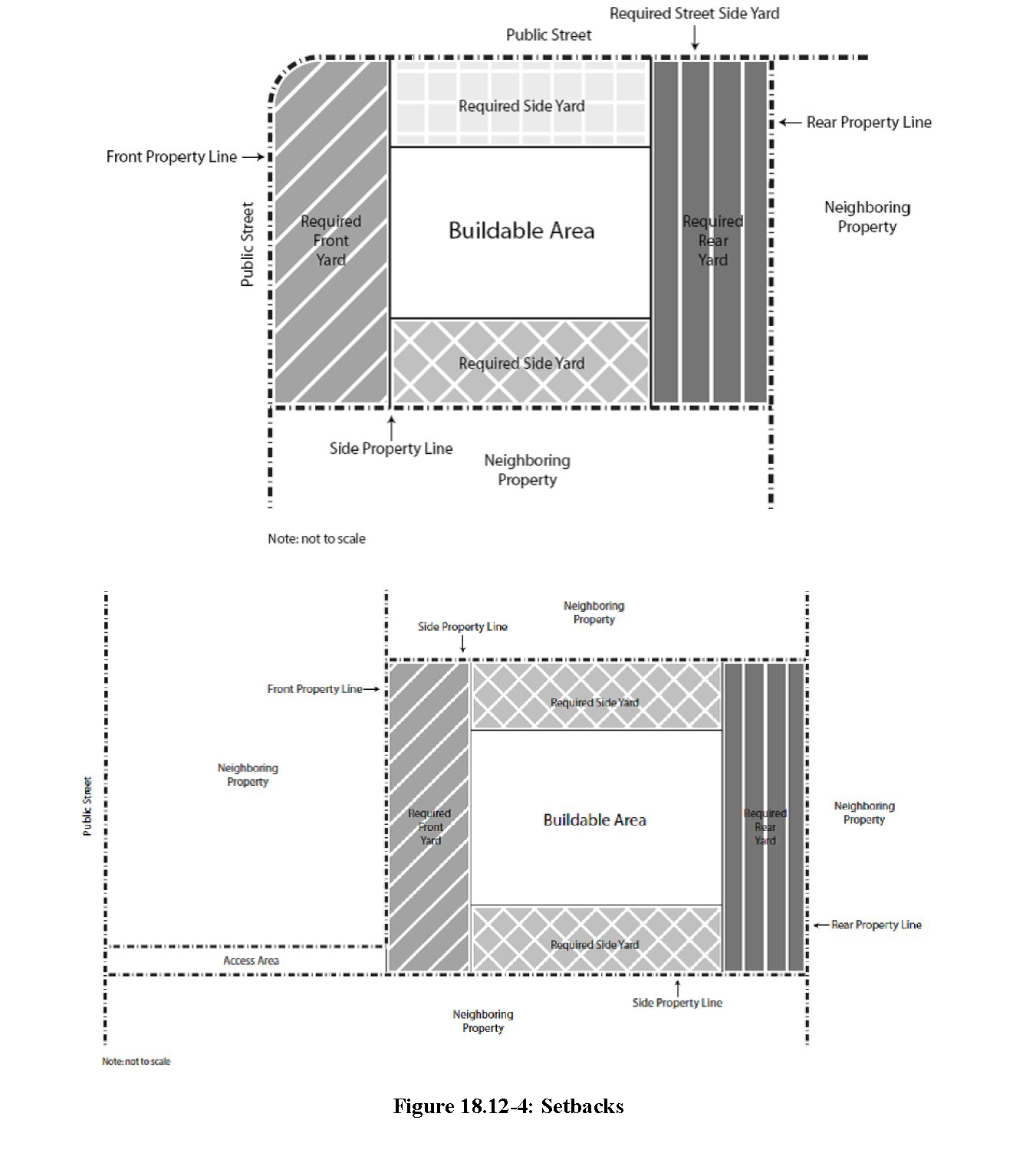
18.12.080 - Setbacks.
A.
Required Setback Area. Required setback areas shall be kept free of buildings and structures. Except as otherwise permitted, required setback areas shall be used only for landscaping, pedestrian walkways, driveways, uncovered off-street parking, recreational activities, or similar accessory activities.
B
Setback Measurements. Setback distances shall be measured at right angles from the designated property line (e.g., front, interior side, street-side, rear) establishing a setback area line parallel to the designated property line at the required setback distance. See Figure 18.12-4. Designated property lines are determined as follows:
1.
Front Property Line. The front property line shall be the narrowest property line which abuts a public or private street easement or drive-aisle. For corner lots, the front property line shall be the shortest street frontage, regardless of where the front door is located. For flag lots, the front property line shall be the property line that abuts the access corridor.
2.
Rear Property Line. The rear property shall be the property line which is opposite and most distant from the front property line and most parallel to the front property line.
3.
Side Property Line. The side property line shall be those property lines that are not the front or rear property lines.
4.
Street Side Property Line. The street side property line shall be those side property lines that abuts a public or private street.
C.
Planned Street Widening. Where a lot abuts a street designated for a future widening, required minimum setbacks shall be measured from the edge of the planned future right-of-way.
D.
Future Street Right-of-Way. Where a future street right-of-way is planned or established, required minimum setbacks shall be measured from property lines that define the edge of the future right-of-way.
E.
Alleys.
1.
If side lot line abuts an alley, the lot line shall be treated as interior side lot line for the purpose of establishing minimum required setbacks.
2.
The width of an adjoining alley is not included in the measurement of a required setback.
F.
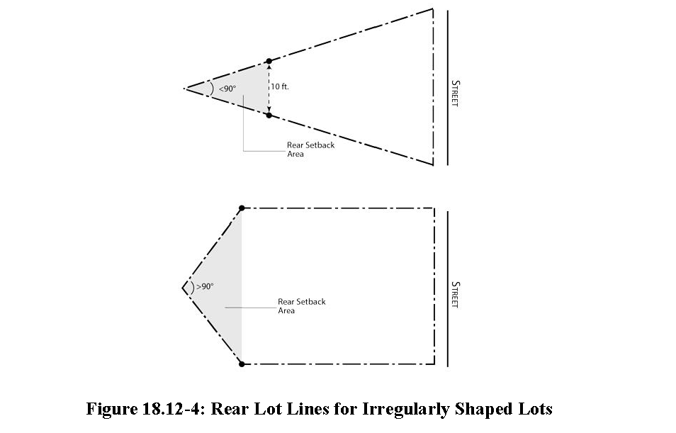
Irregularly Shaped Lots. Where the side lot lines converge to a point at the rear of the lot and make an angle ninety degrees or less, a line ten feet long within the lot, parallel to and at a maximum distance from the front lot line, shall be deemed to be the rear lot line for the purpose of determining the depth of the required rear setback area. Where the angle created by the convergence of two side lot lines at the rear of the lot is greater than ninety degrees, a line ten feet long measured from the point of convergence and perpendicular to the front lot line shall establish the location of the required rear setback line. See Figure 18.12-4.
G.
Double-Frontage Lots. The location of the front and rear yard setbacks on double-frontage lots shall be determined by the development services director based on the placement of existing buildings on adjacent lots.
H.
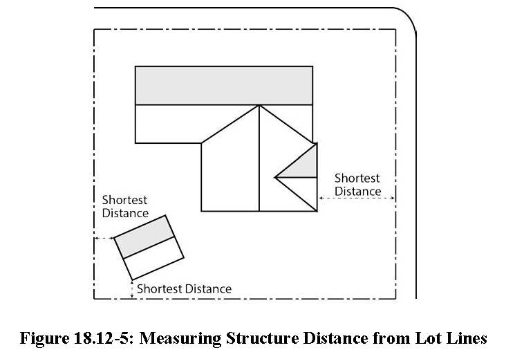
Measuring Structure Distance from Lot Lines. The distance of a structure from a lot line shall be measured as the distance between the lot line and the closest point on the exterior of a building or structure along a line at right angles to the lot line. See Figure 18.12-5.
(Ord. No. 2277 N.S., § 5(Exh. A), 6-6-2018; Ord. No. 2362, § 1, 2-19-2025)
18.12.090 - Slope.
A.
Formula. Average ground slope shall be made using the formula S = .00229(I)(L)/A, where:
1.
S = Average slope (in percent)
2.
I = Contour interval (in feet)
3.
L = Total length of all contour lines on the parcel (in feet)
4.
A = Lot area (in acres)
B.
Contour Intervals. Measurements along contours shall be made at contour intervals not to exceed ten feet, and a horizontal map scale of one inch equals two hundred feet or larger.
(Ord. No. 2277 N.S., § 5(Exh. A), 6-6-2018)