
Morgan Hill City Zoning Code
CHAPTER 18
22 - MIXED USE ZONING DISTRICTS
18.22.010 - Purpose of the mixed use zoning districts.
A.
General. The purpose of the mixed use zoning districts is to provide for active and inviting destinations in Morgan Hill with a diversity of residential and commercial land uses. In the mixed use zoning districts the design of development supports a welcoming, pedestrian-friendly public realm. A diversity of local and independent businesses, recreational amenities, and public spaces meet the needs of residents, workers, and visitors. New development respects Morgan Hill's history and reflects its unique small-town feel. The diversity of land uses, pedestrian-friendly development, and general level of activity in the mixed use zoning districts supports a range of transportation choices, including walking, biking, and transit.
B.
Specific.
1.
Downtown Mixed Use (MU-D). The purpose of the Downtown Mixed Use (MU-D) zoning district is to preserve and enhance Downtown as the heart of Morgan Hill and the center of the community. New development supports a walkable Downtown district with active storefronts and a diversity of commercial, residential, and public uses. The intensity of residential uses enhances economic vitality, increases housing options for residents of all ages, and support a vibrant and diverse destination for residents and visitors. The MU-D zoning district implements the community's vision for Downtown Morgan Hill as described in the Downtown Specific Plan.
2.
Neighborhood Mixed Use (MU-N). The purpose of the Neighborhood Mixed Use (MU-N) zoning district accommodates a range of residential and commercial land uses in close proximity to Downtown. A range of housing types provide residents with affordable housing options and increase opportunities to live close to stores, services, jobs, and transit. The MU-N zoning district provides a transition from the higher intensity uses in the Downtown Core to lower density residential neighborhoods.
3.
Mixed Use Flex (MU-F). The purpose of the MU-F zoning district is to accommodate a mixture of residential and commercial uses typically along the Monterey Road corridor north and south of Downtown. New mixed use development may be vertical (residences above ground floor commercial) or horizontal (separate buildings with different uses on a single site). Development in the MU-F zoning district creates attractive gateways into Morgan Hill, provides a range of housing options, and creates new centers of activity to serve surrounding neighborhoods.
(Ord. No. 2277 N.S., § 5(Exh. A), 6-6-2018; Ord. No. 2319 N.S., § 3, 1-20-2021)
18.22.020 - Land use regulations.
A.
Permitted Land Uses. Table 18.22-1 identifies land uses permitted in the MU-N and MU-F zoning districts. For permitted land uses in the MU-D zoning district, see Figure 8 in the Downtown Specific Plan.
Table 18.22-1: Permitted Land Uses — MU-N and MU-F Zoning Districts
Notes:
[1] Permitted only on a lot of record existing prior to July 7, 2018.
[2] When proposed as a primary use.
[3] On-site wholesale or retail sales required.
[4] Supportive Housing consistent with Government Code Sections 65650-65656 shall adhere to entitlement application timing provisions.
B.
Replacement Housing. Any proposed project that would replace existing rental housing occupied by a low or moderate-income household with commercial development or higher density residential uses shall comply with Municipal Code Chapter 15.30 (Replacement Housing).
C.
Additional Permits. In addition to permits identified in Table 18.22-1, development projects in the mixed use zoning districts may also require a design permit pursuant to Section 18.108.040 (Design Permits). Modifications to a historic resource may require a Historic Alteration pursuant to Chapter 18.60 (Historic Resources).
D.
Residential Building Allotments. All residential development must comply with the voter-approved residential development control system (RDCS) as established in Chapter 18.78 (Residential Development Control System). The RDCS requires proposed residential projects to first receive residential building allotments before applying for land use entitlements. Section 18.78.050.C (Exemptions from Allotments) identifies types of residential projects exempt from the requirement to obtain residential building allotments.
(Ord. No. 2277 N.S., § 5(Exh. A), 6-6-2018; Ord. No. 2319 N.S., § 3, 1-20-2021; Ord. No. 2352, § 3, 4-24-2024)
18.22.030 - Residential and mixed use in the MU-F zoning district.
Residential and residential mixed use is not allowed in the MU-F zoning district until the completion of a master plan for the Monterey Corridor.
(Ord. No. 2277 N.S., § 5(Exh. A), 6-6-2018; Ord. No. 2319 N.S., § 3, 1-20-2021)
18.22.040 - Development standards.
A.
General. Table 18.22-2 identifies development standards that apply in the mixed zoning districts.
Table 18.22-2: Development Standards in Mixed Use Zoning Districts
Notes:
[1] 2.25 FAR permitted on sites 22,000 sq. ft. or more.
[2] Four stories and 55 ft. permitted on sites 22,000 sq. ft. or more.
[3] 45 ft. permitted with a minimum of 10 ft. devoted to a roof element.
[4] 40 ft. allowed for vertical mixed use, regardless of roof form.
B.
Setbacks. Table 18.22-3 identifies setback standards that apply in the mixed zoning districts. Within each zoning district, setback standards for residential uses are different from setback standards for non-residential and mixed use development. See Figure 18.24.
Table 18.22-3: Setback Standards in Mixed Use Zoning Districts
Notes:
[1] Includes mixed use buildings with residential uses above ground floor commercial.
[2] Residential porches and similar entry features may project five feet into the front setback. See Figure 18.22-1.
[3] Building wall must be setback a minimum of ten feet from the edge of curb. See Figure 18.22-2.
[4] Outdoor seating, courtyards, and other publicly-accessible spaces may project five feet into the front setback.
[5] Where a property abuts a residential zoning district or residential land use designation, the property shall comply with increased setbacks, upper story stepbacks, and landscaping standards as specified in Section 18.92.130 (Residential Transition Standards).
C.
Residential Transition Standards — MU-N and MU-F. Where a property zoned MU-N or MU-F abuts a residential zoning district, projects shall comply with increased setbacks, upper story stepbacks, and landscaping standards as specified in Section 18.92.130 (Residential Transition Standards).
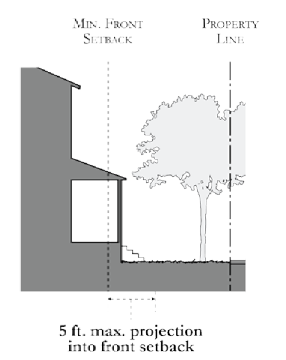
Figure 18.22-1: Permitted Projection Into Front Setback — Residential Uses
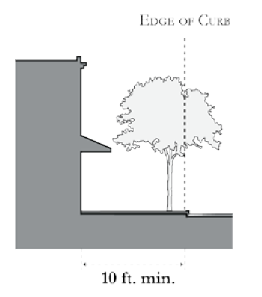
Figure 18.22-2: Minimum Setback From Curb — MU-N Zoning District
(Ord. No. 2277 N.S., § 5(Exh. A), 6-6-2018; Ord. No. 2319 N.S., § 3, 1-20-2021; Ord. No. 2363, § 4, 3-5-2025)