Muscatine City Zoning Code
CHAPTER 10
19 2023 Muscatine, Iowa Airport Land Use And Height Overlay Zoning Ordinance
10-19-1 Introduction
This Ordinance shall regulate and restrict the height of structures, objects, and growth of natural vegetation, as well as regulate and restrict land uses; otherwise regulating the use of property, within the vicinity of the Muscatine Municipal Airport. Creation of appropriate zones and establishing the boundaries thereof, as well as providing for changes in the restrictions and boundaries of such zones, is vested in this Ordinance. The Muscatine Municipal Airport Land Use and Height Zoning Map, is incorporated into and made part of this Ordinance. The Ordinance also provides for the enforcement of the Ordinance, the establishment of an Airport Board of Adjustment; and imposition of penalties related to the implementation of the Ordinance.
This ordinance is intended to supplement and be interpreted as an overlay of existing zoning regulations of the municipalities and counties in which the airport zoning boundaries cover. Those governmental jurisdictions affected by this ordinance are the City of Muscatine, Iowa, City of Fruitland, Iowa, Muscatine County, Iowa, Louisa County, Iowa, and Rock Island County, Illinois. The 2023 Muscatine, Iowa Airport Land Use and Height Overlay Zoning Ordinance is created by the City of Muscatine, with assistance from Anderson Bogert (of Cedar Rapids, Iowa).
10-19-2 Authority
Iowa Code Section 329.3, Airport Zoning, empowers local municipalities to regulate land uses and restrict building heights in the vicinity of airports, including dividing such area into zones, and within such zones, specifying the land uses permitted, and regulating and restricting, for the purpose of preventing airport hazards, the heights to which structures and trees may be erected or permitted to grow.
10-19-3 Statement Of Purpose And Findings
The Muscatine Municipal Airport is acknowledged as an essential public facility to the State of Iowa and the local community.
The creation or establishment of an airport hazard is a public nuisance and poses a potential safety concern to the surrounding communities served by the Muscatine Municipal Airport.
No creation or establishment of a hazard shall occur that endangers public health, safety, welfare, or impacts an individual's quality of life, nor prevents the safe movement of aircraft using the Muscatine Municipal Airport.
For the protection of the public health, safety, and general welfare, and for the promotion of the most appropriate use of land, preventing the creation or establishment of airport hazards is a necessity.
The prevention of airport hazards shall be accomplished, to the extent legally possible, by proper exercise of the police power.
The prevention of new airport hazards; the elimination, removal, alteration, mitigation, or marking and lighting of existing airport hazards; and the acquisition of property or easements are all considered to be a public purpose for which the City of Muscatine, City of Fruitland, Muscatine County, Louisa County, and Rock Island County may raise and expend public funds; these actions shall be considered incidental to the operation of the Muscatine Municipal Airport. The need to plan for compatible land use near airports is not a new concept. Compatible land use was recognized as early as 1952 in a document entitled The Airport and Its Neighbors - The Report of the President’s Airport Commission. As stated in the Iowa Airport Land Use Guidebook, the incidence of incompatible land uses and impact on airport operations and development have escalated. As decisions to allow incompatible land uses near airports threaten the nation’s aviation system, implementation of compatible land use controls have become an industry priority. Maintaining an obstruction-free airport and associated airspace is important for the Muscatine Municipal Airport. This includes the area that encompasses the airport, runway protection zones, approach areas, and general vicinity of the airport. While some of these areas are owned by the City, the bulk of the land beyond airport boundaries is privately owned and needs to be managed by the local municipalities and/or counties in which the airport jurisdiction falls. FAA criteria, such as grant assurances and design guidelines, along with aviation accident statistics, provide the foundation and the justification for airport compatible land use regulations.
Lastly, land use compatibility is critical to the Muscatine Municipal Airport, because certain grant assurances are required as part of a project application from airports that are eligible to request federal funds. Upon acceptance of grant money, these assurances are incorporated into and become part of the grant agreement. The airport sponsor is obligated to comply with specific assurances, which include the maintenance of compatible land use within the vicinity of the airport. Specifically, Grant Assurance 21 included in the September 1999 amendment to 49 USC 47107, requires all airports that accept federal money to take appropriate action against incompatible land uses in the immediate vicinity of the airport. Such actions include adopting zoning laws and zoning changes that will increase airport land use compatibility. This grant assurance obligates an airport sponsor to protect the federal investment through the maintenance of a safe operating environment. The development of compatible land uses near airports is supported through cooperative comprehensive planning that includes FAA standards. Land use compatibility is a requirement for eligibility to receive FAA grant money for airport improvements. Adjacent land uses that are not compatible with airports may result in the loss of federal or state funding for the adjacent airports.
10-19-4 Short Title
This Ordinance shall be known and may be cited as the 2023 Muscatine, Iowa Airport Land Use and Height Overlay Zoning Ordinance, and it is referred to as “the Ordinance” within the following sections.
10-19-5 Applicability
10-19-6 Definitions
- Air Traffic. (FAA FAR Sec. 1.1) Aircraft operating in the air or on an airport surface, exclusive of loading ramps and parking areas.
- Airport. (FAA FAR Sec. 152.3) Any areas of land or water that is used, or intended for use, for the landing and takeoff of aircraft. Any appurtenant areas that are used, or intended for use, for airport buildings, other airport facilities, or rights-of-way; and all airport buildings and facilities located on the areas specified in this definition. The Muscatine Municipal Airport is owned by the City of Muscatine, Iowa.
- Airport Elevation. (FAA AC 150/5190-4A) The highest point on an airport's usable landing area measured in feet from sea level.
- Airport Hazard. (FAA FAR Sec. 152.3) Any structure or object of natural growth located on or in the vicinity of a public airport, or any use of land near a public airport that obstruct the airspace required for the flight of aircraft landing or taking off at the airport; or is otherwise hazardous to aircraft landing or taking off at the airport.
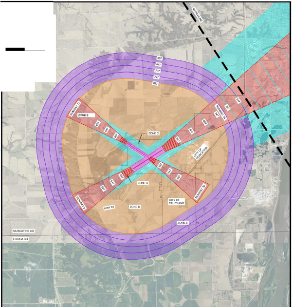
- Airport Land Use and Height Overlay Zoning Map. The Airport Land Use and Height Overlay Zoning Map is compiled from the criteria in FAR Part 77, "Objects Affecting Navigable Airspace.” It shows the area affected by the Airport Land Use and Height Overlay Zoning Ordinance, and includes the layout of runways, airport overlay zones A-E, airport overlay zone elevations, and area aerial imagery. Applicable height limitations are shown in detail.
- Airport Land Use and Height Overlay Zoning Permit. Airport land use and height overlay zoning permit allowing new development or allowing alteration or expansion of a nonconforming use in the vicinity of the airport.
- Airport Overlay Zones. A zone intended to place additional land use conditions on land impacted by the airport while retaining the existing underlying zone. The FAR Part 77 Surfaces and RPZs have been combined to create five airport overlay zones for this ordinance. The five specific zones, which are listed below, comprise a comprehensive area focused on maintaining compatible land use around the Muscatine Municipal Airport. Definitions for each individual zone can be found in Section 9.A. of this Ordinance.
- Zone A (Runway Protection Zone)
- Zone B (Approach Surface)
- Zone C (Transitional Surface)
- Zone D (Horizontal Surface)
- Zone E (Conical Surface)
- Airspace. (FAA Web site) The space lying above the earth or above a certain area of land or water that is necessary to conduct aviation operations.
- Approach Slopes. (FAR Part 77) The ratios of horizontal to vertical distance indicating the degree of inclination of the Approach Surface. The various ratios include:
- 20:1. For all utility and visual runways extended from the primary surface a distance of 5,000 feet.
- 34:1. For all non-precision instrument runways extended from the primary surface for a distance of 10,000 feet.
- 50:1/40:1. For all precision instrument runways extending from the primary surface for a distance of 10,000 feet at an approach slope of 50:1 and an additional 40,000 feet beyond this at a 40:1 Approach Slope.
- Approach Surface. (FAA AC 150/5190-4A) A surface longitudinally centered on the extended runway centerline, extending outward and upward from the end of the primary surface and at the same slope as the approach zone height limitation slope set forth in this Ordinance. The perimeter of the approach surface coincides with the perimeter of the approach zone.
- Commercial Uses. Commercial uses means a use category including land uses or activities involving the production, processing, manufacturing, or sale of goods or services for financial gain, including uses that provide merchandise to the general public. Accessory uses may include offices, storage, food service, or other amenities primarily for the use of employees and parking.
- Compatibility. The degree to which land uses or types of development can coexist or integrate.
- Easement. (FAA AC 5020-1) The legal right of one party to use a portion of the total rights in real estate owned by another party. This may include the right of passage over, on, or below property; certain air rights above the property, including view rights; and the rights to any specified form of development or activity, as well as any other legal rights in the property that may be specified in the easement document.
- Federal Aviation Administration (FAA). (FAA Web site) A federal agency charged with regulating air commerce to promote its safety and development; encourage and develop civil aviation, air traffic control, air navigation; and promoting the development of a national system of airports.
- Federal Aviation Regulations (FAR). (FAA FAR) Regulations established and administered by the FAA that govern civil aviation and aviation-related activities.
- FAR Part 36. (FAA FAR Sec. 36.1) Regulation establishing noise standards for the civil aviation fleet.
- FAR Part 91. (FAA FAR Sec. 91.1) Regulation pertaining to air traffic and general operating rules, including operating noise limits.
- FAR Part 150. (FAA FAR Sec. 150.1) Regulation pertaining to airport noise compatibility planning.
- FAR Part 161. (FAA FAR Sec. 161.1) Regulation pertaining to notice and approval of airport noise and access restrictions.
- FAR Part 77. (FAA FAR Sec. 77.1) Objects Affecting Navigable Airspace - Part 77 (a) establishes standards for determining obstructions in navigable airspace; (b) defines the requirements for notice to the FAA Administrator of certain proposed construction or alteration; (c) provides for aeronautical studies of obstructions to air navigation to determine their effect on the safe and efficient use of airspace; (d) provides for public hearings on the hazardous effect of proposed construction or alteration on air navigation; and (e) provides for establishing antenna farm areas.
- Height. Height is utilized for the purpose of determining the height limits in all zones set forth in this Ordinance and shown on the Official Airport Land Use and Height Overlay Zoning Map (Exhibit A); height shall be measured as the highest point of a structure, tree, or other object of natural growth, measured from the mean sea level elevation unless otherwise specified.
- Imaginary Surfaces. (FAA FAR Part 77.25) Those areas established in relation to the airport and to each runway consistent with FAR Part 77 in which any object extending above these imaginary surfaces, by definition, is an obstruction.
- Transitional surface. The transitional surface extends outward and upward at right angles to the runway centerline and extend at a slope of seven feet horizontally for each one foot vertically (7:1) from the sides of the primary and approach surfaces. The transitional surfaces extend to the point at which they intercept the horizontal surface at a height of 150 feet above the established airport elevation.
- Horizontal surface. The horizontal surface is a horizontal plane, typically elliptical in shape, located 150 feet above the established airport elevation and encompasses an area from the transitional surface to the conical surface. The perimeter is constructed by generating arcs from the center of each end of the primary surface and connecting the adjacent arcs by lines tangent to those arcs. The radius of each arc for all runway ends is 10,000 feet.
- Conical surface. The conical surface extends upward and outward from the periphery of the horizontal surface at a slope of 20 feet horizontally for every one foot vertically (20:1) for a horizontal distance of 4,000 feet.
- Approach surface. The approach surface is longitudinally centered on the extended runway centerline and extends outward and upward from the end of the runway primary surface. The approach slope of a runway is a ratio of 20:1, 34:1, or 50:1, depending on the approach type. The length of the approach surface varies from 5,000 to 50,000 feet and also depends upon the approach type.
- Incompatible Land Use. (FAA FAR Sec. 150.7) The use of land which is normally incompatible with the aircraft and airport operations (such as, but not limited to, homes, schools, nursing homes, hospitals, and libraries).
- Industrial, Wholesale Trade, and Storage Uses. A use category including the following use types:
- Industrial development or uses involved in the research, design, manufacturing, processing, fabrication, packaging, or assembly of goods. Natural, man-made, raw, secondary, or partially completed materials may be used. Products may be finished or semi-finished and are generally made for the wholesale market, for transfer to other plants, or to order for firms or customers. Goods are generally not displayed or sold on site, but if so, they are a subordinate part of sales (typically 10% or less of the total gross floor area). Relatively few customers come to the site.
- Industrial, manufacturing, wholesale trade, and warehouse/storage uses including uses that produce goods from raw or finished materials, uses that distribute goods in large quantities to primarily wholesale customers, or provide for storage or warehousing of goods, either in enclosed buildings or outdoors. Few customers, especially the general public, come to the site. Accessory activities may include sales, offices, parking, and storage.
- Land Use Compatibility. (FAA Web site) The coexistence of land uses surrounding the airport with airport-related activities.
- Lighting and Marking of Hazards to Air Navigation. Installation of appropriate lighting fixtures, painted markings or other devices to such objects or structures that constitute hazards to air navigation.
- Mitigation. (FAA Web site) The avoidance, minimization, reduction, elimination or compensation for adverse environmental effects of a proposed action.
- Navigable Airspace. The airspace above minimum altitude for safe flight, and includes the airspace needed to ensure safety in take-off and landing of aircraft.
- Noise Exposure Contours. (FAA Web site) Lines drawn around a noise source indicating constant energy levels of noise exposure. DNL is the measure used to describe community exposure to noise.
- Noise Impact. A condition that exists when the noise levels that occur in an area exceed a level identified as appropriate for the activities in that area.
- Noise Sensitive Area. (FAA AC 91-36D) Defined as an area where noise interferes with normal activities associated with the area’s use. Examples of noise-sensitive areas include residential, educational, health, and religious structures and sites, and parks, recreational areas (including areas with wilderness characteristics), wildlife refuges, and cultural and historical sites where a quiet setting is a generally recognized feature or attribute.
- Non-Conforming Use. (FAA Web site) Any pre-existing structure, tree, or use of land that is inconsistent with the provisions of the local land use or airport master plans.
- Non-Precision Instrument Runway. (FAA AC 150/5190-4A) A runway having an existing instrument approach procedure utilizing air navigation facilities with only horizontal guidance, or area type navigation equipment, for which a straight-in non- precision instrument approach procedure has been approved or planned.
- Object. (FAA AC 150/5300-13) Includes, but is not limited to above ground structures, navigational aids, people, equipment, vehicles, natural growth, terrain, and parked aircraft.
- Obstacle Free Zone (OFZ). (FAA 150/5300-13) The OFZ is the airspace below 150 feet (45 m) above the established airport elevation and along the runway and extended runway centerline that is required to be clear of all objects, except for the frangible visual navigational aids that need to be located in the OFZ because of their function, in order to provide clearance protection for the aircraft landing or taking off from the runway, and for missed approaches.
- Obstruction. (FAA AC 150/5190-4A) Any structure, growth, or other object, including a mobile object, which exceeds a limiting height, specific to its geographic location relative to the runway/airport.
- Overlay Zone. (FAA Web site) A mapped zone that imposes a set of requirements, in addition to those of the underlying zoning district.
- Part 150 Study. (FAA Web site) Part 150 is the abbreviated name for the airport noise compatibility planning process outlined in Part 150 of the Federal Aviation Regulation (FAR) that allows airport owners to voluntarily submit noise exposure maps and noise compatibility programs to the FAA for review and approval. See "Noise Compatibility Plan."
- Primary Surface. (FAA AC 150/5190-4A) A surface longitudinally centered on a runway. When the runway has a specially prepared hard surface, the primary surface extends 200 feet beyond each end of that runway; for military runways or when the runway has no specially prepared hard surface, or planned hard surface, the primary surface ends at each end of that runway. The width of the primary surface is set forth in FAR Part 77. The elevation of any point on the primary surface is the same as the elevation of the nearest point on the runway centerline.
- Primary Runway. (FAA AC 150/5325-4B General Definition) The runway used for the majority of airport operations. Large, high-activity airports may operate two or more parallel primary runways.
- Public Assembly Use. A structure or outdoor facility where concentrations of people gather for purposes such as deliberation, education, shopping, business, entertainment, amusement, sporting events, or similar activities, but excluding air shows. “Public assembly use” does not include places where people congregate for relatively short periods of time, such as parking lots and bus stops, or uses approved by the FAA in an adopted airport master plan.
- Residential and Accommodation Uses. Mean a use category that includes the following use types:
- Residential uses that provide living accommodations, including sleeping, eating, cooking and sanitary facilities, to one or more persons, and where tenancies typically last longer than 30 days.
- Accommodation uses characterized by visitor-serving facilities that provide temporary lodging in guest rooms or guest units, for compensation, and with an average length of stay of less than 30 days. Accessory uses may include pools and other recreational facilities for the exclusive use of guests, limited storage, restaurants, bars, meeting facilities, and offices.
- Runway Protection Zone (RPZ). (FAA AC 150/5300-13) An area off the runway end intended to provide a clear area that is free of above-ground obstructions and structures. RPZs are designed with the intent to protect people and property on the ground. They are located at the end of each runway and should ideally be controlled by the airport. Control is preferably exercised by acquisition of sufficient property interest to achieve and maintain an area that is clear of all incompatible land uses, objects, and activities.
- Structure. Any object constructed or installed by humans, including, but without limitation, buildings, towers, smokestacks, and overhead transmission lines, including the poles or other structures supporting the same.
- Variance. An authorization for the construction or maintenance of a building or structure, or for the establishment or maintenance of a use of land that is prohibited by a zoning ordinance. A lawful exception from specific zoning ordinance standards and regulations predicated on the practical difficulties and/or unnecessary hardships on the petitioner being required to comply with the regulations and standards from which a variance is sought.
- Visual Approach. (FAA Web site) An approach to an airport conducted with visual reference to the terrain.
- Visual Runway. (FAA AC 150/5300-13) A runway without an existing or planned straight-in instrument approach procedure.
- Wetland. Land on which water covers the soil or is present either at or near the surface of the soil or within the root zone, all year or for varying periods of time during the year, including during the growing season. (FAA AC 150/5200-33A) Wetlands provide a variety of functions and can be regulated by local, state, and Federal laws. Normally, wetlands are attractive to many types of wildlife, including many, which rank high on the list of hazardous wildlife species.
- Wildlife Attractants. Any human-made structure, land-use practice, or human-made or natural geographic feature that can attract or sustain hazardous wildlife within the landing or departure airspace or the airport’s air operations area. These attractants include, but are not limited to, architectural features, landscaping, waste disposal sites, wastewater treatment facilities, agricultural or aquaculture activities, surface mining, or wetlands.
- Wildlife Hazards. Species of wildlife (birds, mammals, reptiles), including feral animals and uncontrolled domesticated animals, that are associated with aircraft strike problems, are capable of causing structural damage to airport facilities, or act as attractants to other wildlife that pose a strike hazard.
10-19-7 Airport Zoning Requirements
In accordance with Section 329.10, Iowa Code, there are three (3) principal airport zoning requirements supported by additional information contained within the following remaining sections of this ordinance. These basic zoning requirements state:
- All airport zoning regulations adopted under this ordinance shall be reasonable and none shall impose any requirement or restriction that is not necessary to make effective the purposes of this ordinance
-
- Airport zoning regulations under this ordinance, when adopted or amended, may require the removal, lowering, or other change or alteration of any structure or tree, or a change in use, not conforming to the regulations when adopted or amended.
- Airport zoning regulations adopted under this ordinance may require a property owner to permit the City of Muscatine to install, operate, and maintain on the property markers and lights as necessary to indicate to operators of aircraft the presence of the airport hazard, when adopted or amended.
- All such regulations may provide that a preexisting nonconforming structure, tree, or use, shall not be replaced, rebuilt, altered, allowed to grow higher, or replanted, so as to constitute a greater airport hazard than it was when the airport zoning regulations or amendments to the regulations were adopted.
The City of Muscatine will be responsible for the initial removal of trees, structures, or other natural or man-made obstructions that are not conforming to the regulations of this ordinance when adopted or amended. Any subsequent alterations or removal of any natural or man-made obstructions to the Muscatine Municipal Airport or its airspace will be responsibility of the property owner.
10-19-8 Airport Land Use And Height Overlay Zoning Map
The Airport Land Use & Height Overlay Zoning Districts established by this Ordinance are shown on the Muscatine Municipal Airport Land Use & Height Overlay Zoning Map, consisting of 2 sheets, prepared by Anderson Bogert, attached as Exhibit A to this Ordinance. Such Official Airport Land Use & Height Overlay Zoning Map, may be amended from time to time, and all notations, references, elevations, data, zone boundaries, and other information thereon, is hereby adopted as part of this Ordinance.
10-19-9 Airport Land Use And Height Overlay
The Muscatine Municipal Airport's FAR Part 77 Surfaces and RPZs have been combined to create five airport land use and height overlay zones. These five zones are identified to help maintain compatible land uses around the Muscatine Municipal Airport. Land uses shall be evaluated against these zones, by the City, in order to determine compatibility.
- Definition of Airport Overlay Zones.
- The five airport overlay zoning districts for the Muscatine Municipal Airport are prescribed within this Ordinance. Specific dimensions for the individual zones for each runway end are noted in the following tables and text.
In addition, the Airport Land Use and Height Overlay Zoning Map should be used by the City to help determine the specific area of impact to land use and building heights associated with each airport overlay zone.
- Zone A – Runway Protection Zone (RPZ). Zone A is intended to provide a clear area that is free of above-ground obstructions and structures. This zone is closest to the individual runway ends. The dimensional standards for this zone are the same as those described in the Airport Design AC (AC 150/5300-13B) and are shown in the following table.
Table 1: Zone A (RPZ) Dimensional Requirements1 The RPZ dimensional standards are for the runway end with the specified approach visibility minimums. The departure RPZ dimensional standards are equal to or less than the approach RPZ dimensional standards. Source: FAA AC 150/5300-13B, Airport Design Standards
Dimensions Runway Ends Approach Visibility Minimums 1 Length L Feet Inner Width W1 feet Outer Width W2 feet RPZ acres Runway 24 1/2 mile 2,500 1,000 1,750 78.9 Runway 6 1 mile 1,700 500 1,010 29.5 Runway 12 Not < 1 mile 1,000 500 700 13.8 Runway 30 Not < 1 mile 1,000 500 700 13.8 - Zone B – Approach Surface. Zone B is a critical airport overlay zoning surface that reflects the approach and departure areas for each runway at an airport. The size of Zone B is predicated upon the type of approach (visual, non- precision, or precision) that a specific runway has and the type/size of aircraft utilizing the runway. The following table illustrates the various sizes of Zone B based upon the specific runway criteria at the Muscatine Municipal Airport. A portion of Zone B is overlain by Zone A because the approach surface and RPZ overlap the entire length of the RPZ. Consequently, the length of Zone B begins at the inner edge of the RPZ.
Table 2: Airport Overlay Zones B-E Dimensional StandardsItem Runway Dimensional Standards (Feet) Runway 24 Runway 6 Runway 12 Runway 30 Primary surface width and Zone B inner width 1,000 1,000 500 500 Zone B end width 16,000 3,500 3,500 3,500 Zone B length 50,000 10,000 10,000 10,000 Zone C width 1,050 1,050 1,050 1,050 Zone D radius 10,000 10,000 10,000 10,000 Zone E width 4,000 4,000 4,000 4,000 - Zone C – Transitional Surface. Zone C includes those areas that are parallel to the runway pavement and extend 1,050’ from the edge of the primary surface, paralleling the runway and extended runway centerline, until they reach the end of Zone A at a 90-degree angle. The specific dimensions for Zone C are based upon various options for the primary surface that is predicated upon the type of approach and critical aircraft.
- Zone D – Horizontal Surface. Zone D is typically elliptical in shape, but is dependent upon the runway types and the runway configurations at the airport.
- Zone E – Conical Surface. Zone E is the outermost zone of the airport overlay zoning areas and has the least number of land use restriction considerations. The zone begins at the edge of the horizontal surface and is 4,000 feet in width paralleling the horizontal surface. Height limitations for the surface range from 150 feet above the airport reference elevation at the inner edge to 350 feet at the outer edge.
- Zone A – Runway Protection Zone (RPZ). Zone A is intended to provide a clear area that is free of above-ground obstructions and structures. This zone is closest to the individual runway ends. The dimensional standards for this zone are the same as those described in the Airport Design AC (AC 150/5300-13B) and are shown in the following table.
Table 1: Zone A (RPZ) Dimensional Requirements
- The five airport overlay zoning districts for the Muscatine Municipal Airport are prescribed within this Ordinance. Specific dimensions for the individual zones for each runway end are noted in the following tables and text.
In addition, the Airport Land Use and Height Overlay Zoning Map should be used by the City to help determine the specific area of impact to land use and building heights associated with each airport overlay zone.
- Zone Compatibility. The following tables shall be utilized to assist in evaluating land use compatibility for various land use classifications.
- Uses identified as compatible (C) in the tables shall not require additional review; however, consideration should always be given to the following five areas of concerns, when evaluating land uses in the vicinity of the airports:
- Noise sensitive related issues
- High concentrations of people
- Tall structures
- Visual obstructions
- Wildlife and bird attractants
- Uses identified as NOT compatible (NC) in the tables shall be precluded from development within the specific zones.
- Uses found to require additional review (AR) in the tables shall be evaluated for general compatibility utilizing the Compatible Land Use Planning Checklist (Appendix J of the Iowa Airport Land Use Guidebook) and the five primary areas of concern noted above.
Nearly every type of land use can be considered both compatible and incompatible relative to airport operations, depending upon the particular aspects of the land use, including management of the land use, and exact location of the land use relative to the airport. For example, land uses typically considered to be compatible with airport operations include commercial, industrial, and agricultural activities.
However, each of these may contain aspects considered incompatible, such as:
Some commercial uses may have dense concentrations of people.
Some industrial uses may generate smoke/steam that creates visual obstructions.
Some agricultural operations can create wildlife attractants in certain circumstances.
The City of Muscatine, the City of Fruitland, Muscatine County, Louisa County, and Rock Island County shall each independently assess and collaboratively assess the compatibility of the land uses in detail in the vicinity of the Muscatine Municipal Airport. Table 3: Residential Land Use Versus Airport Overlay ZonesMuscatine Municipal Airport Zone Chart C = Compatible AR = Additional Review Required NC = Not Compatible Land Uses Zone A Zone B Zone C Zone D Zone E Residential Activities Single-Family Uses (1 dwelling per lot) Detached Single Family Dwelling
(i.e. farm dwelling, detached single family house, manufactured/modular/mobile homes if converted to real property and taxed)NC AR AR AR C Detached Zero Lot Line Dwelling (i.e. condominium) NC AR AR AR C Attached Single Family Dwelling (i.e. townhouses) NC AR AR AR C Two Family Uses (i.e. two principal dwelling units within one building on the same parcel) NC AR AR AR C Multi-Family Uses (i.e. three or more principal dwelling units within a single building on the same parcel, apartments such as condominium, elder, assisted living, townhouse-style) Low-Rise (1-3 Levels) NC AR AR AR C Mid-Rise (4-12 Levels) NC AR AR AR C High-Rise (13+ Levels) NC AR AR AR AR Group Living Uses (i.e. assisted living, group care facilities, nursing and convalescent homes, independent group living) NC AR AR AR C Manufactured Housing Parks NC AR AR AR C
Table 4: Commercial Land Use Versus Airport Overlay ZonesMuscatine Municipal Airport Zone Chart C = Compatible AR = Additional Review Required NC = Not Compatible Land Uses Zone A Zone B Zone C Zone D Zone E Commercial Activities Eating and Drinking Establishments
(i.e. restaurants, cafes, coffee shops, fast food restaurants, bars, nightclubs, taverns, cocktail lounges)NC AR AR AR C Quick Vehicle Servicing Uses
(i.e. full-serve and mini-serve gas station, unattended card key service stations, car washes)NC AR AR C C Office Uses (i.e. business, government, professional, medical, or financial) General Office (i.e. professional offices, financial businesses, government offices) NC AR AR AR C Low-Rise (1-3 Levels) NC AR AR AR C Mid-Rise (4-12 Levels) NC AR AR AR C High-Rise (13+ Levels) NC AR AR AR AR Medical/Dental Office (i.e. medical and dental clinics, chiropractic clinics, physical therapy clinics) NC AR AR AR C Low-Rise (1-3 Levels) NC AR AR AR C Mid-Rise (4-12 Levels) NC AR AR AR C High-Rise (13+ Levels) NC AR AR AR AR Retail Uses (i.e. sale, lease, or rent of new or used products) Sales-Oriented
(i.e. appliances, convenience stores, bakeries, electronics, furniture, garden supplies, gas stations, groceries, hardware, malls, strip malls, videos)NC AR AR C C Personal Service-Oriented
(i.e. retail service-banking establishments, laundromats/dry cleaning, quick printing services, beauty/tanning salons, funeral homes)NC AR AR AR C Repair-Oriented
(i.e. consumer goods-electronics, office equipment, appliances)NC AR AR C C Hospitality-Oriented
(hotels, motels, convention centers, meeting halls, event facilities)NC AR AR AR C Low-Rise (1-3 Levels) NC AR AR AR C Mid-Rise (4-12 Levels) NC AR AR AR C High-Rise (13+ Levels) NC AR AR AR AR Outdoor Storage and Display-Oriented
(i.e. outdoor storage- lumber yards, vehicles sales, landscape material and nursery product sales, farm supply and equipment sales)NC AR AR C C Surface Passenger Services
(i.e. passenger terminals for buses, rail services, local taxi and limousine services)NC AR AR C C Vehicle Repair Uses
(i.e. vehicle repair or service shops, alignment shops, tire sales)NC AR AR C C
Table 5: Industrial/Manufacturing Land Use Versus Airport Overlay Zone
- Uses identified as compatible (C) in the tables shall not require additional review; however, consideration should always be given to the following five areas of concerns, when evaluating land uses in the vicinity of the airports:
10-19-10 Ordinance Administration
This section identifies the entity who will administer and enforce the regulations prescribed in the Ordinance. This section will also define the powers given to the administrator to exercise his/her duties and procedures within the provision of the Ordinance
It shall be the duty of the City of Muscatine, Iowa, Community Development Director, or designee, referred to herein as the “Airport Zoning Administrator”, to administer the regulations prescribed herein. Applications for permits and variances shall be made to the Airport Zoning Administrator upon forms furnished by the Airport Zoning Administrator. Applications for action by the Airport Board of Adjustment shall be forthwith transmitted by the Airport Zoning Administrator, should an applicant request review. Permit applications shall be either granted or denied by the Airport Zoning Administrator, according to the regulations prescribed herein.
As stated in Section 329.13, Iowa Code, all airport zoning regulations adopted under this ordinance shall provide for the administration and enforcement of such regulations by an administrative agency. For purposes of the 2023 Muscatine, Iowa Airport Land Use and Height Overlay Zoning Ordinance, the administration will be enforced by the Muscatine Airport Zoning Administrator with consultation and cooperation from the City of Fruitland City Clerk, the Muscatine County Engineer, the Louisa County Engineer, and the Rock Island County Engineer. However, in no case, shall such administrative agency be or include any member of the Airport Board of Adjustment. The duties of any administrative agency designated pursuant to the Iowa Code or this ordinance shall not include any of the powers herein delegated to the Airport Board of Adjustment. The Muscatine Airport Zoning Administrator will be recognized as the official Airport Zoning Administrator, since the operation of the Muscatine Municipal Airport falls within the jurisdiction of the City of Muscatine. However, if needed, the City of Fruitland City Clerk, the Muscatine County Engineer, the Louisa County Engineer, and/or the Rock Island County Engineer may be called upon from time to time, to consult with and/or confer with the Airport Zoning Administrator about the airport zoning ordinance regulations.
10-19-11 Non-Conforming Uses
The intent of this ordinance is to discourage their continuance, but to permit existing legal nonconforming buildings, structures, or natural resources to continue until they are removed, unless such nonconforming use is determined by the FAA to be a hazard within one of the airport zones and required to be altered or changed in accordance with FAA regulations.
Furthermore, the intent of this ordinance is that nonconformities shall not be enlarged upon, expanded, or extended, nor be used to add other nonconforming structures prohibited elsewhere in the defined airport zones.
- In accordance with Section 329.10, Iowa Code, and stated above in Section 10-19-7 of this ordinance, any preexisting nonconforming structure, tree, or land use, shall
not be replaced, rebuilt, altered, allowed to grow higher, or replanted, so as to constitute a greater airport hazard than it was when these airport zoning regulations or amendments to these regulations were adopted. With that stated, where a lawful building or structure exists prior to the effective date of adoption or amendment of this ordinance that could not be built under the terms of this airport ordinance by reason of restrictions on height or land use compatibility, such structure may be continued, so long as it remains otherwise lawful and in compliance with FAA regulations; subject to the following provisions:
- No such nonconforming structure may be enlarged or altered in a way that increases its nonconformity. Such structure may be enlarged or altered in a way that does not increase its nonconformity.
- Should such nonconforming structure be destroyed by any means to an extent of more than seventy-five percent (75%) of its replacement cost, it shall be reconstructed only in conformity with the provisions of this airport ordinance.
- Should any nonconforming structure be moved within the boundaries of any of the five (5) airport zones for any reason or for any distance whatever, it shall thereafter conform to the regulations of this airport zoning ordinance.
- Discontinuance. In the event a nonconforming building, structure or use is discontinued for a period of one (1) year, its height and land use compatibility shall conform thereafter to the provisions of this airport zoning ordinance.
- On any nonconforming building or structure, work may be done on ordinary repairs or replacement of non-bearing walls not exceeding seventy-five percent (75%) of the assessed value of the building, provided the cubic content of the building shall not be increased. Nothing in this ordinance shall be deemed to prevent the strengthening or restoring to a safe condition of any building or part thereof declared to be unsafe by an official charged with protecting the public safety upon orders of such official. A change of tenancy, ownership, or management of any existing nonconforming uses of land, buildings or structures shall be allowed under this ordinance.
10-19-12 Airport Land Use And Height Overlay Zoning Permits
- The duty of the applicant shall include providing the Airport Zoning Administrator with sufficient information to evaluate the proposed action. This information shall include but not be limited to the following:
- Contact information
- Structure information including: location based on State Plane Coordinates NAD 83, and vertical control based on the NAVD 88 control system; proposed finish floor elevation of structure; and height of structure
- Site information
- Drawing information
- Certification
- Identify current and potential compatibility concerns (from the following five areas of concern: noise sensitive related issues, high concentrations of people, tall structures, visual obstructions, and wildlife/bird attractants)
- Buildings or other structures located within the Muscatine Municipal Airport land use and height overlay zoning area, which is defined herein, shall be reviewed in accordance with the allowable height and land use classifications accordingly. All proposed land uses, exclusive of communication uses (e.g. specifically cell towers, antennas, etc.), utility uses (e.g. specifically wind generators, wind farms) and waste related uses (e.g. specifically landfills), shall not be subject to any further review of the airport zoning ordinance, if such proposed building or structure is located within airport overlay Zones D and E and such building or structure meets the height requirements indicated on the Muscatine Airport Land Use and Height Overlay Zoning Map.
Furthermore, those proposed buildings or structures to be located within airport overlay zones A, B, and C of the Muscatine Municipal Airport land use and height overlay zoning area, which is defined herein, shall automatically be reviewed by the Airport Zoning Administrator, in accordance with both height and land use conformance. The Airport Zoning Administrator shall determine if such proposed building or structure meets the initial criteria for additional height and land use review or if the proposed use is exempted from additional review. If the affected jurisdiction determines an additional level of review is needed, the appropriate authority shall submit a copy of the permit under review to the Airport Zoning Administrator. Upon review by the Airport Zoning Administrator, comments and a recommendation on approval, approval with conditions or denial of such permit shall be returned to the originating jurisdiction, in which the proposed building or structure is located. The Airport Zoning Administrator shall approve the permit if after evaluation, the proposed project is found to be adequately compatible. Should the proposed project be found to be incompatible after review, the Airport Zoning Administrator shall recommend denial of the permit. Should the permit be denied, the applicant shall have the right to request an appeal, as prescribed in this ordinance. Any airport zoning review shall be null and void, if the purpose for which the permit is issued has not commenced within one (1) year from date of issuance. Should the activity commence after that time, a new airport zoning review shall be required.
10-19-13 Marking And Lighting Of Airport Hazards
This section identifies lighting and marking requirements in the vicinity of the airport, in order to help provide for safe aircraft operations, as well as for the health, safety, and welfare of individuals on the ground.
- Lighting and marking requirements will be determined through an FAA 7460-1 airspace analysis. The applicant shall provide Notice of the Proposed Construction or Alteration to the FAA, by filing form 7460-1 electronically via the OEAAA website.
- The owner of any structure, object, natural vegetation, or terrain is hereby required to install, operate, and maintain such markers, lights, and other aids to navigation necessary to indicate to the aircraft operators, in the vicinity of an airport, the presence of an airport hazard. Hazard markers and lights shall be installed, operated, and maintained at the expense of the owner of such building, structure, or object requiring such lighting or marking within the findings of the 7460-1 airspace analysis.
10-19-14 Height Limitations
- No structure, object, natural vegetation, or terrain shall be erected, altered, allowed to grow or be maintained within any airport zoning district established by this Ordinance to a height in excess of the applicable height limitations set forth in this Ordinance and the Airport Land Use and Height Overlay Zoning Map. The permitted height shall not exceed the difference between the grade elevation and the height limitation numbers illustrated on the “Official Airport Land Use and Height Overlay Zoning Map” within the various airport zones encompassed by this Ordinance. The Airport Land Use and Height Overlay Zoning Map is attached as Exhibit A and is located in the Office of the City Clerk (City of Muscatine), Fruitland City Hall, the Muscatine County Engineer's Office, the Louisa County Engineer's Office, and the Rock Island County Engineer's Office.
- An FAA 7460-1 airspace review shall provide a portion of the information necessary to evaluate potential height impacts; however, it shall not be the sole source of review.
10-19-15 Airport Board Of Adjustment
- The Muscatine Airport Board of Adjustment shall consist of two (2) members from the City of Muscatine, one (1) from the City of Fruitland, and one (1) from Muscatine County, selected from sitting members of the respective entities Board of Adjustment and appointed by the governing body thereof, along with one (1) additional member to be selected by the Muscatine Airport Advisory Commission. The five (5) appointed members will select a chairperson amongst themselves.
Airport Board of Adjustment members may be removed for cause by the appointing authorities (either City of Muscatine, City of Fruitland, or Muscatine County) upon written charges and after a public hearing. Vacancies shall be filled for the unexpired term of any member whose office becomes vacant, in the same manner in which said member was selected. The terms of the board members shall be for five (5) years. - Any person, property owner, or taxpayer impacted by any decision of this ordinance, may appeal to the Airport Board of Adjustment. According to Section 329.12, Code of Iowa, the governing body of any municipality seeking to exercise powers under Chapter 329, shall by ordinance provide for the appointment of a Board of Adjustment, as provided in section 414.7 for a city, or as provided in section 335.10 for a county. The board of adjustment has the same powers and duties, and its procedure and appeals are subject to the same provisions as established in Code of Iowa sections 414.9 to 414.19 for a city, or sections 335.12 to 335.21 for a county. The concurring vote of a majority of the board shall be necessary to reverse any order, requirement, decision, or determination of any administrative official or to decide in favor of the applicant on any matter upon which it is required to pass under any regulations adopted pursuant to this chapter or to affect any variance therefrom.
10-19-16 Variances
In accordance with Section 239.11, Code of Iowa, any person desiring to erect, alter, or increase the height of any structure, object, or to permit the growth of any natural vegetation, or otherwise use his property in violation of airport zoning regulations adopted under this ordinance, may apply to the Airport Board of Adjustment for variance from such zoning regulations. Such variances shall be allowed where a literal application or enforcement of the regulations would result in practical difficulty or unnecessary hardship, and the relief granted would not be contrary to the public interest, but would do substantial justice and be in accordance with the spirit of the regulations and this chapter; provided, however, that any such variance may be allowed subject to any reasonable conditions that the Airport Board of Adjustment may deem necessary to effectuate the purposes of this Ordinance. No application for variance to the requirements of this Ordinance may be considered by the Airport Board of Adjustment, unless a copy of the application has been submitted to the Muscatine Municipal Airport Zoning Administrator for an opinion as to the aeronautical effects of the variance.
10-19-17 Appeals
Any person aggrieved, or any taxpayer affected, by any decision by the Airport Zoning Administrator made in the administration of this Chapter may appeal to the Airport Board of Adjustment by complying with the provisions of Section of the City of Muscatine Zoning Ordinance.
10-19-18 Judicial Review
Any person or persons, or any board, taxpayer, department, board or bureau of the city aggrieved by any decision of the Airport Board of Adjustment may seek review of such decision of the Board by a Court of Record in the manner provided by the laws of the State of Iowa and particularly by Section 414.15, Code of Iowa.
10-19-19 Penalties
- Unless provided elsewhere in this ordinance or in the city’s Code of Ordinances, any person, firm, corporation, or agent who violates, disobeys, omits, neglects, or refuses to comply with, or resists the enforcement any of the provisions of this ordinance or any amendment thereof; or who shall build or alter any building in violation of this ordinance, with the exception of those provisions specifically provided under State law as a felony, an aggravated misdemeanor, a serious misdemeanor, or a simple misdemeanor under Chapters 687 through 747 of the Code of Iowa, shall be charged with a municipal infraction, which is punishable by civil penalty, as provided herein (Code of Iowa, Sec. 331.307[3]). Each day that a violation continues to exist constitutes a separate violation.
- A municipal infraction for an airport zoning violation in Muscatine, Iowa is punishable under the following civil penalties: (Code of Iowa, Sec. 331.307[1])
- First offense – no less than $250 and not to exceed $750.00, not including court costs
- Second and repeat offenses – no less than $250 and not to exceed $1,000.00, not including court costs
- A municipal infraction for an airport zoning violation in Muscatine, Iowa is punishable under the following civil penalties: (Code of Iowa, Sec. 331.307[1])
- The owner or tenant of any building, structure, premises or part thereof, and any architect, builder, contractor, agent or other person who commits, participates in, assists in, or maintains such violation, may each be found guilty of a separate offense and suffer the penalties herein provided. Nothing herein contained shall prevent the city from taking such other lawful action as is necessary to prevent or remedy any violation.
- In case any building or structure is erected, constructed, reconstructed, altered, repaired, converted, or maintained, or any building, structure, or land is used in violation of this ordinance, the City Attorney, in addition to other remedies, may institute any proper action or proceed in the name of the City of Muscatine to prevent such unlawful erection, construction, reconstruction, alteration, repair, conversion, maintenance, conduct, business, or use in or about said premises.
10-19-20 Conflicting Regulations
In accordance with Section 329.8, Code of Iowa, where there exists a conflict between any of the regulations or limitations prescribed in this Ordinance and any other regulations applicable to the same area, whether the conflict be with respect to height or structures, the use of land, or any other matter, the more stringent limitation or requirement shall govern and prevail.
10-19-21 Severability
If any provision of this Ordinance or the application thereof to any person or circumstances is held invalid, such invalidity shall not affect other provisions or applications of the Ordinance, which can be given effect without the invalid provision or application, and to this end, the provisions of this Ordinance are declared to be severable.
10-19-22 Effective Date
This ordinance shall be in effect from and after its adoption by the governing body with publication and posting as required by law, as provided for in Chapter 380.6 and 380.7, Iowa Code. (Code of Iowa, Sec. 380.6[1]; Sec. 380.7[3]; and Sec. 362.3).
Exhibit A Airport Land Use And Height Overlay Zoning Map
The exhibit provides the Official Airport Land Use and Height Overlay Zoning Map to be kept on file with the appropriate governmental entities. The map must be amended when changes occur within the jurisdictional map boundaries. The map shall be adopted concurrently with this Ordinance.