Rome City Zoning Code
ARTICLE XXII
- RIGHT-OF-WAY AND ACCESS STANDARDS
Sec. 80-22.1. - Purpose.
The purpose of these right-of-way and access standards is to:
(a)
Design rights-of-way to provide safe, convenient, and functional pedestrian, bicycle, and vehicular traffic flow.
(b)
Design circulation patterns within communities so that children can walk to school.
(c)
Encourage safe pedestrian routes to transit.
(d)
Use visual cues and design elements to indicate pedestrian rights-of-way and minimize conflicts.
(e)
Make places walkable for aging populations in response to new demographics and special needs.
(f)
Limit the use of cul-de-sacs when possible.
(Ord. No. 9301A, 9-26-18)
Sec. 80-22.2. - Blocks.
(a)
Block length. Residential blocks must not exceed 1,000 feet in length, unless approved by the city engineer.
(b)
Block design.
i.
The shape of a new block must be generally rectangular, but may vary to conform to natural features, highway and rail rights-of-way, park boundaries, or site constraints. Where blocks curve, they must generally maintain their cardinal orientation over their entire trajectory.
ii.
New rights-of-way must connect to and extend the existing block network where possible. This requirement does not apply when connections cannot be made because of a natural or man-made barrier, such as existing structures, steep slopes, wetlands and waterbodies, railroad and utility rights-of-way, and parks and dedicated open space.
iii.
All rights-of-way must terminate at other rights-of-way, forming a network. The city engineer may approve cul-de-sacs and dead-end streets when they meet the following criteria:
a.
No connection is available to an existing adjacent development or a natural or man-made barrier, such as a waterway, railroad, limited-access expressway, or unusual topography, exists that prevents connection.
b.
The cul-de-sac or dead-end street is no more than 600 feet in length, as measured along the centerline from the closest intersection.
iv.
Where adjoining areas are not developed, rights-of-way in new subdivisions must extend to the project boundary line where feasible to make provision for the future projection of rights-of-way into the adjoining areas.
v.
Alleys may be required for new or reconfigured blocks. Where blocks have an existing alley, such alley must be maintained.
(Ord. No. 9301A, 9-26-18)
Sec. 80-22.3. - General right-of-way standards.
All new construction, reconstruction, and reconfiguration of rights-of-way must comply with this section. This does not apply to limited access expressways. Rights-of-way must be designed in relation to topographic and drainage conditions, public safety, and the development served by the right-of-way.
(a)
Right-of-way construction.
i.
All right-of-way construction and repair must be in accordance with standards and specifications set forth by the city engineer.
ii.
Vertical and horizontal alignment must be in accordance with standards and specifications set forth by the city engineer.
iii.
Street grades must conform in general to the terrain and the minimum grade will be based on surface type of the roadway as determined by the city engineer.
(b)
Access and intersection requirements.
i.
All public and private rights-of-way must be improved as complete streets. A complete street is defined as right-of-way facilities that are designed and operated to enable safe access for all users. Persons with disabilities, pedestrians, bicyclists, motorists, and transit riders are able to safely move along and across a right-of-way designed as a complete street.
ii.
If a new subdivision involves frontage on a major street, the street layout should be planned to avoid, to the extent possible, any private residential driveways from having direct access to such streets.
iii.
Street intersections must be at right angles. If, because of topography or other natural or man-made barriers, an intersection cannot be at right angles, the intersection may use an alternate design that ensures safety.
(c)
Property line and curb radius. Curb radii cannot be less than 25 feet and must be increased proportionately where the angle of intersection is less than 50 degrees. These minimums may be increased where the city engineer finds that larger arcs or radii are necessary for the proper design of the intersection.
(d)
Drainage. Proper drainage is the responsibility of the subdivider. The type of drainage system and its design must be approved by the city engineer. Green infrastructure designs are encouraged.
(e)
Utility installation. Prior to paving of streets or sidewalks, water and sewer mains and services must be in place, or the developer must provide necessary casing for utilities. No pavement may be cut without the approval of the city engineer. No boring of new pavement is allowed for the installation of new service lines mains or other facilities unless approved by the city engineer.
(Ord. No. 9301A, 9-26-18)
Sec. 80-22.4. - Sidewalk design standards.
(a)
Sidewalks must be provided on both sides of all rights-of-way, with the exception of a rural right-of-way type per section 80-22.6 or when determined by the planning board that sidewalks do not need to be installed. Sidewalks are not required where one side of the right-of-way is a steep vertical wall, railroad, or other feature where the public does not require access.
(b)
Sidewalks must be paved with a permanent, fixed, non-slip material.
(c)
Sidewalks must be as straight and direct as possible.
(d)
Where sidewalks cross driveways, the sidewalk zone must remain level, with no change in cross-slope.
(Ord. No. 9301A, 9-26-18)
Sec. 80-22.5. - Bicycle lane design standards.
Where bicycles lanes are included in right-of-way construction, reconstruction, and reconfiguration projects, appropriate designs include, but are not limited to, the design types of this section. Where installed, bicycle facilities, should be constructed in accordance with the Manual on Uniform Traffic Control (MUTCD) and the Urban Bikeway Design Guide published by the National Association of City Transportation Officials (NACTO).
(a)
Shared. A marking placed in a vehicular travel lane to indicate that a bicyclist may use the full lane. Also called a shared-lane marking.
(b)
Bike lane. A portion of the roadway that has been designated by striping, signs, and pavement markings for the preferential or exclusive use of bicyclists, typically located adjacent to motor vehicle travel lanes and flowing in the same direction as motor vehicle traffic.
(c)
Buffered bike lane. A conventional bicycle lane paired with a designated buffer space separating the bicycle lane from the adjacent motor vehicle travel lane and/or parking lane.
(d)
Contra-flow bike lane. A bicycle lane designed to allow bicyclists to ride in the opposite direction of motor vehicle traffic, typically used to convert a one-way traffic street into a two-way street, one direction being for motor vehicles and bikes, and the other being for bikes only.
(e)
Left-side bike lane. A conventional bike lane placed on the left side of one-way streets or two-way median divided streets.
(f)
Cycle track. An exclusive bike facility that combines the user experience of a separated path with the on-street infrastructure of a conventional bike lane. A cycle track is physically separated from motor traffic and distinct from the sidewalk.
(g)
Raised cycle track. A bicycle facility that is vertically separated from motor vehicle traffic, typically paired with a furnishing zone between the cycle track and motor vehicle travel lane and/or pedestrian area, and allowing for one-way or two-way travel by bicyclists.
(h)
Two-way cycle track. A physically separated cycle track that allows bicycle movement in both directions on one side of the road.
(Ord. No. 9301A, 9-26-18)
Sec. 80-22.6. - Right-of-way dimensions.
All rights-of-way must match one of the right-of-way types of this section, which may be modified as needed by the city engineer to address specific site conditions.
(a)
Right-of-way types. The classifications of rights-of-way are divided into the following:
i.
Major streets carry the majority of trips entering and leaving the city, as well as the majority of through movements.
ii.
Collector streets provide both access to and traffic circulation within residential neighborhoods, commercial, and industrial areas. Collector streets differ from major streets in that collector streets enter residential neighborhoods, distributing trips from arterials through the area to destinations. Collector streets also collect traffic from local streets in residential neighborhoods and channel into the arterial system.
iii.
Minor streets primarily provide direct access to abutting land and access to the higher order street.
iv.
Alleys are a vehicular drive located to the rear of lots providing access to service areas, parking, and outbuildings, and often containing utility easements.
v.
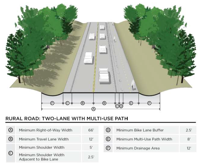
Rural roads provide access and circulation through portions of the planning area that are largely undeveloped or rural in character.
(b)
Right-of-way dimensional requirements. Minimum dimensions are provided for each right-of-way type in this section. The illustrative examples are also provided to illustrate a potential configuration of a right-of-way type. Variations to these configurations may be approved by the city engineer. All dimensions indicated are minimums, unless otherwise noted.
Figure 80-12-1: Minor Street: Neighborhood Yield Street
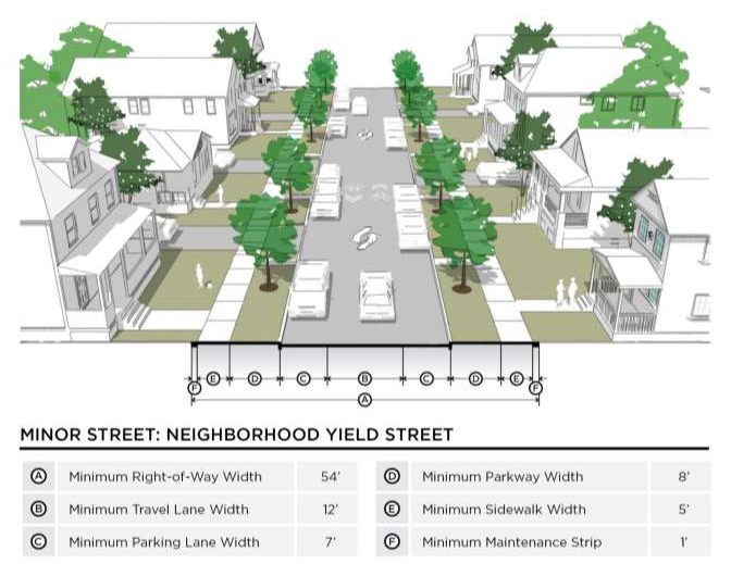
Figure 80-12-2: Minor Street: Neighborhood Two-Lane Local Street
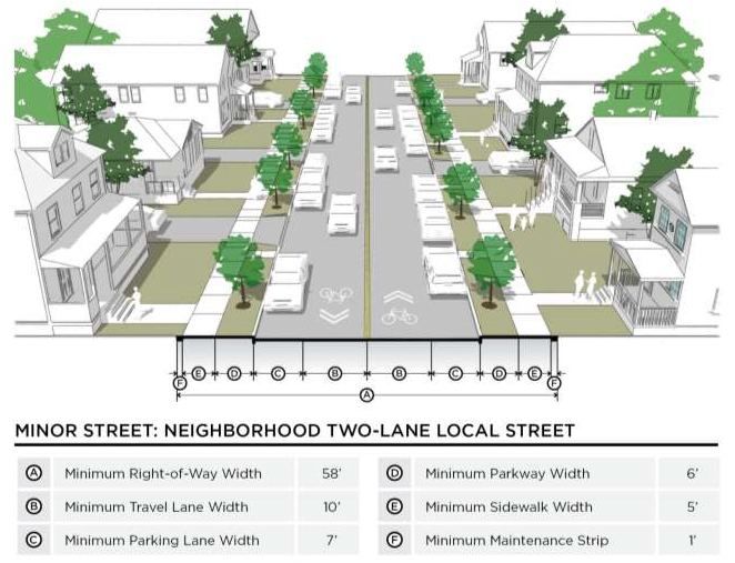
Figure 80-12-3: Minor Street: Neighborhood Two-Lane Street
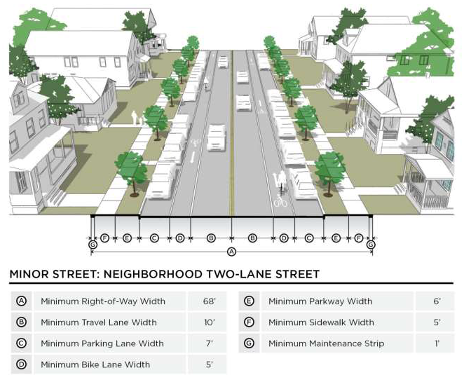
Figure 80-12-4: Minor Street: Neighborhood Two-Lane Divided Street
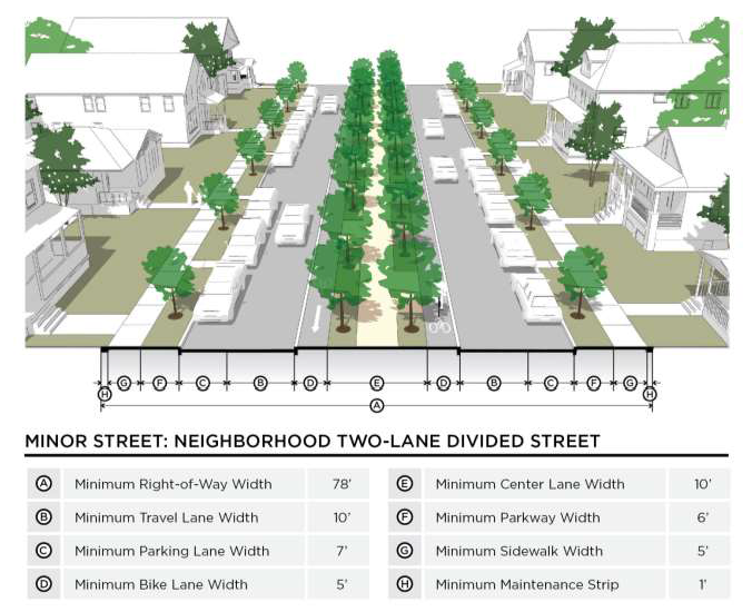
Figure 80-12-5: Collector: Two-Lane Undivided
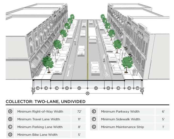
Figure 80-12-6: Collector: Two-Lane Divided
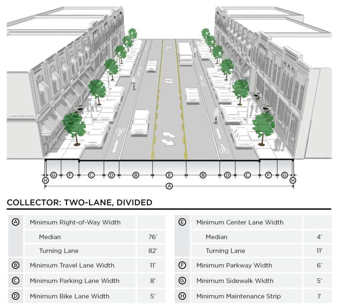
Figure 80-12-7: Collector: Four-Lane Undivided
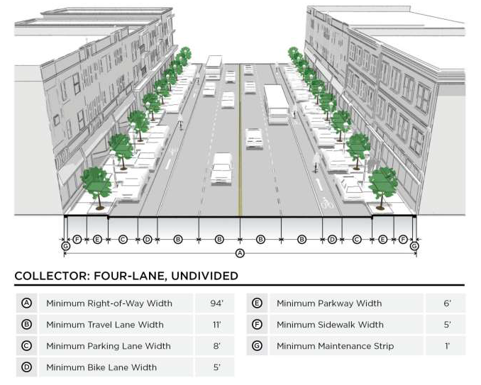
Figure 80-12-8: Collector: Four-Lane Divided
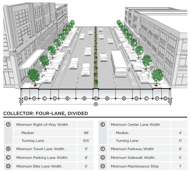
Figure 80-12-9: Arterial Street: Four-Lane Undivided
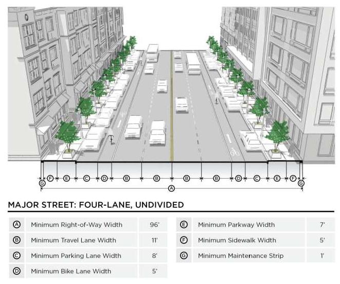
Figure 80-12-10: Major Street: Four-Lane Divided
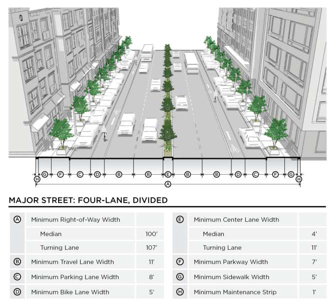
Figure 80-12-11: Arterial Street: Six-Lane Undivided
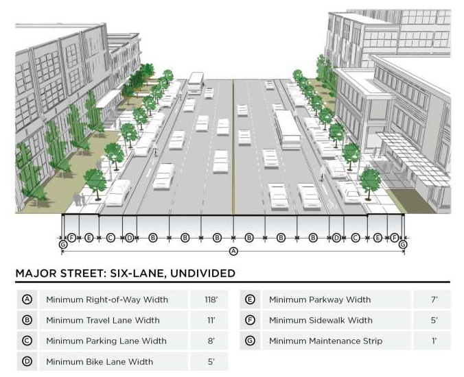
Figure 80-12-12: Arterial Street: Six-Lane Divided
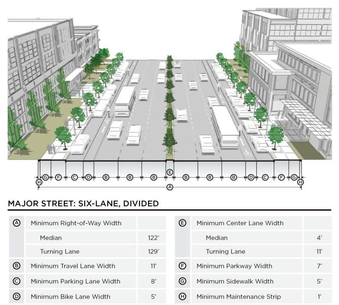
Figure 80-12-13: Alley
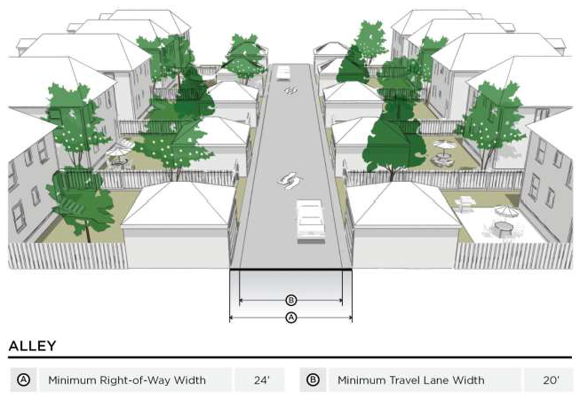
Figure 80-12-14: Rural Road: Two-Lane
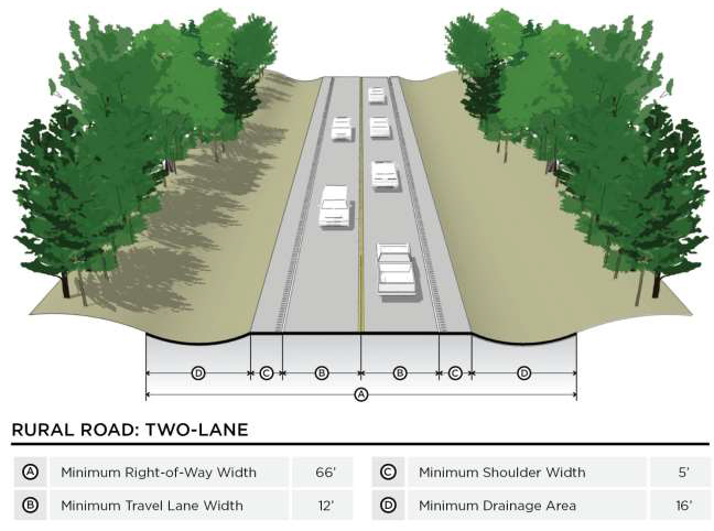
Figure 80-12-15: Rural Road: Two-Lane With Multi-Use Path