
Rome City Zoning Code
ARTICLE IX
- FORM-BASED CODES FOR SPECIFIC GEOGRAPHIES
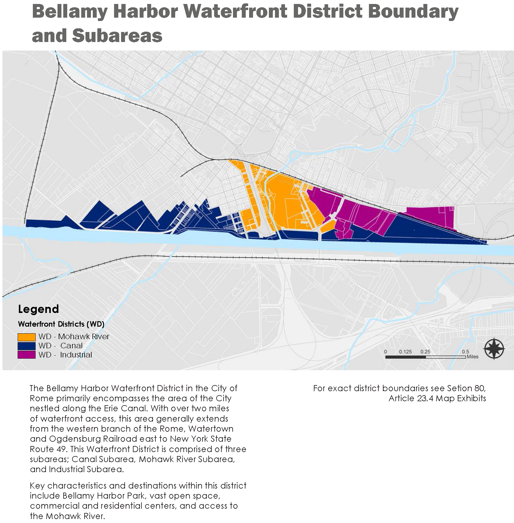
DIVISION 1. - BELLAMY HARBOR WATERFRONT DISTRICT
Rome's Design Objectives
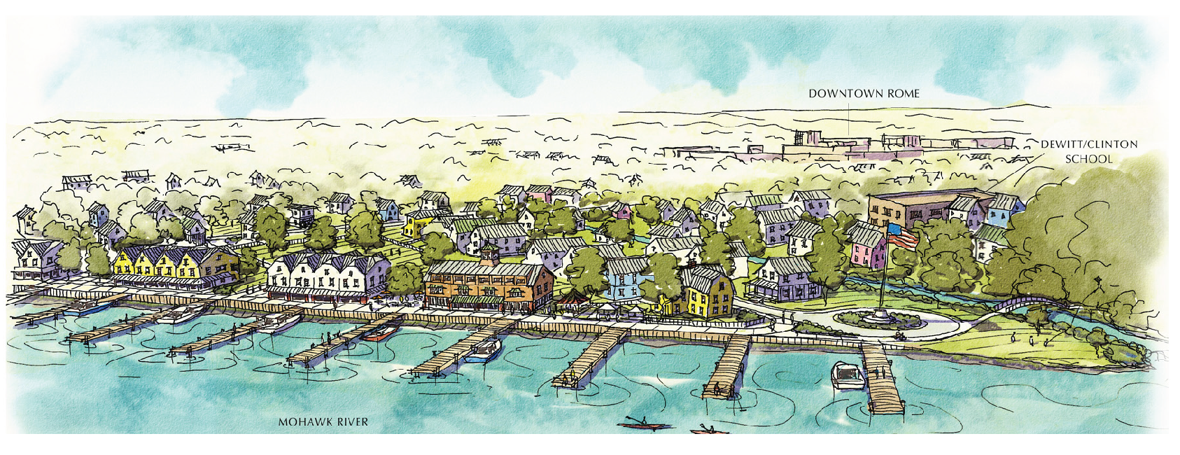
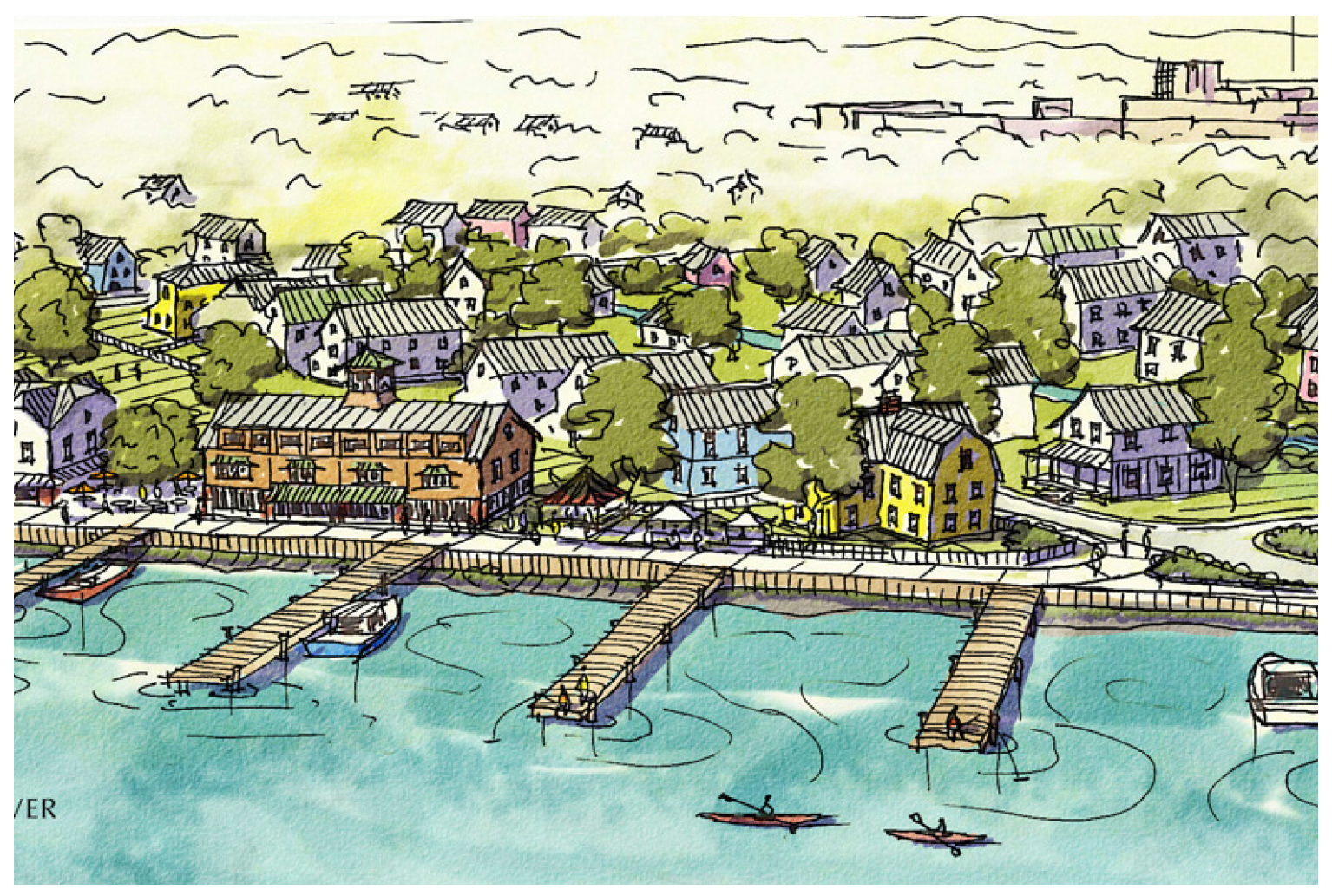
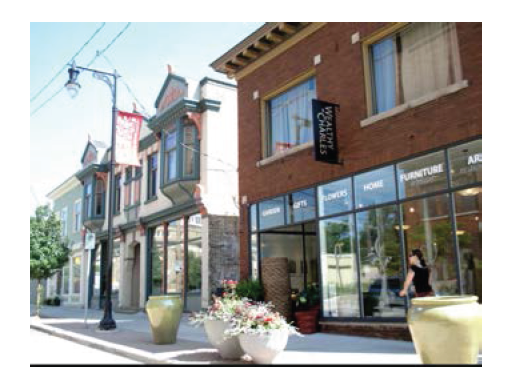
Design traditions are a useful way to understand the basic character and framework of Rome's waterfront. These features serve as inspiration for new, compatible infill and are considered in the overall objectives for redevelopment in the waterfront district.
Design objectives include:
• Engaging the waterfront.
• Public access to waterfront areas.
• Facades built to the sidewalk at a human scale.
• Active ground floors and utilized upper levels in multi-story buildings.
• Windows allowing interior visibility.
• Pedestrian-oriented street features, such as sidewalks, crosswalks, and mid-block connections, and bike paths.
• Street trees, planter boxes, and benches.
• Attractive signage.
• Strong urban tree canopy.
• High quality landscape design.
• Green infrastructure practices for stormwater management.
(Ord. No. 9301A, 9-26-18)
DIVISION 2. - WOODHAVEN REDEVELOPMENT DISTRICT
Design Objectives
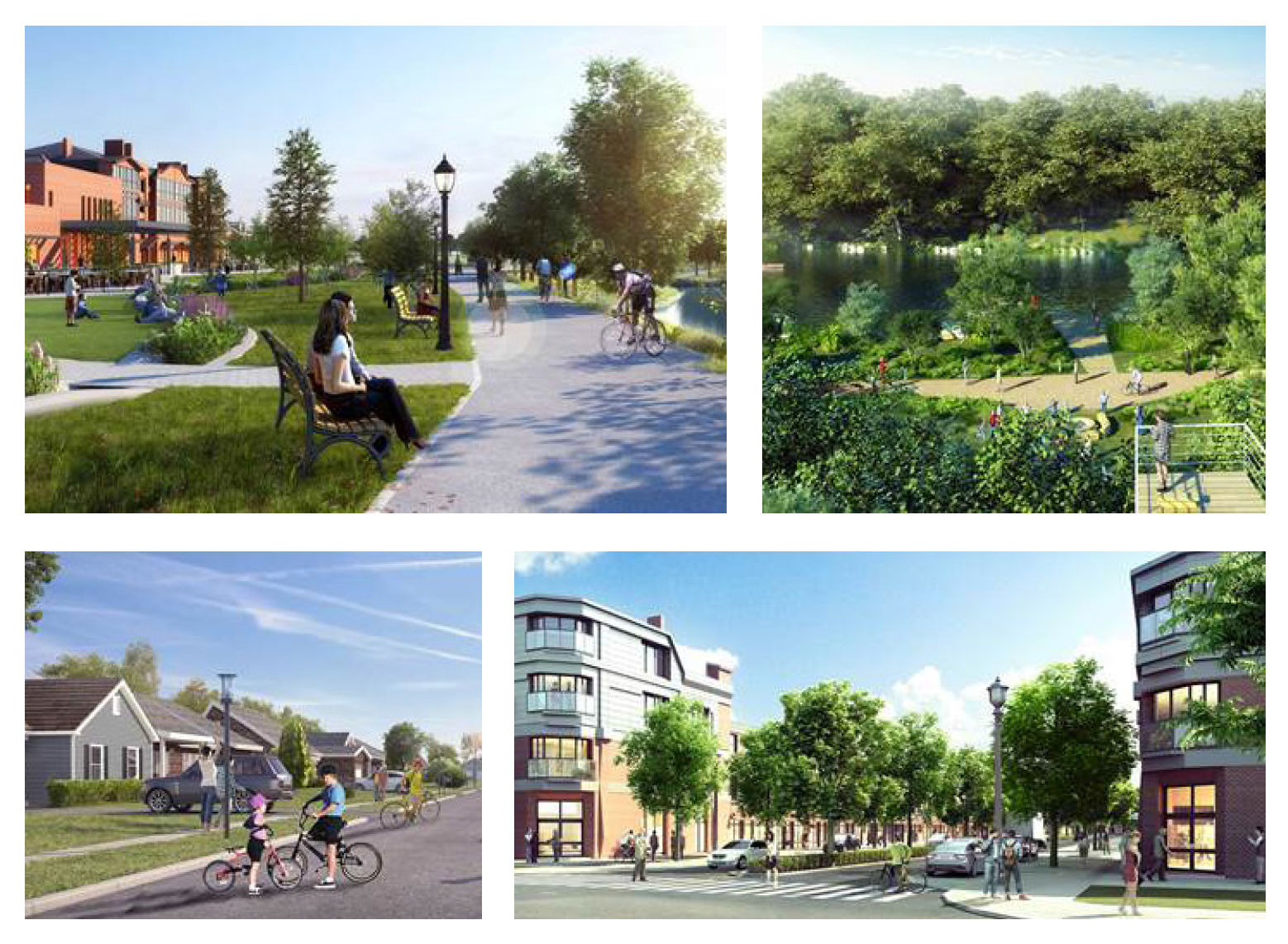
The Woodhaven Redevelopment District seeks to realize the community's vision for the most dynamic, sustainable and attractive mixed-use neighborhood in Upstate New York with a high standard for design and a practicable phased redevelopment strategy. Design objectives strive to provide a sustainable mixed-use revitalization plan to advance Smart Growth principles and include:
• Mix land uses.
• Compact building designs.
• Create a range of housing opportunities and choices.
• Create an accessible and multi-generational, walk-able community.
• Foster distinct, attractive communities with a strong sense of place.
• Preserve open space, natural beauty, and critical environmental areas.
• Engage the waterfront of the Mohawk River.
• Strengthen and direct development toward existing communities.
• Provide a variety of multimodal transportation choices.
Sec. 80-9.1. - Waterfront district.
A.
Introduction. This section provides regulatory standards governing land use and building form within the waterfront district. The form-based code is a reflection of the community's vision for Bellamy Harbor and implements the intent of the comprehensive plan and the City of Rome Downtown Brownfield Opportunity Area Plan.
Upon adoption, it will supersede and replace existing zoning provisions regarding zoning districts, allowable land uses, permit requirements, and site development standards.
1.
Purpose and intent. The purpose of the waterfront district is to create a vibrant, pedestrian friendly waterfront with a variety of building types that offer retail, service, employment, hospitality, entertainment, housing options and public access to the waterfront. The district is also intended to protect and enhance water quality within the Mohawk River and Erie Canal.
2.
Thresholds and compliance. This section recognizes lawful nonconforming status of uses and structures and normal maintenance is encouraged. This section also recognizes that some sites may be difficult to develop in compliance with the provisions herein and provides for modifications within certain parameters.
The provisions in this section shall apply to all development or redevelopment of property within the waterfront district as outlined in the applicability matrix.
3.
Exemptions. The following are exempt from the provisions of this section:
• Regular maintenance and repair of materials, parking resurfacing and similar maintenance is exempt from compliance with this section.
• Improvements that are solely designed and constructed to provide accessibility for the disabled or provide screening for service areas, as long as such service areas are no longer visible.
4.
Conflicting provisions. In the event that this section conflicts with any other provision of the Rome Zoning Code or the attached appendices, the provision of this section shall supersede, except that where this section is silent, the Rome Zoning Code or the attached appendices shall apply.
B.
Subareas established. The waterfront district is hereby divided into subareas shown on the map entitled "district boundaries and subareas" which is hereby made part of this ordinance.
• WD—Canal.
• WD—Industrial.
• WD—Mohawk River.
C.
Use regulations. With the exception of the prohibited uses listed below, all uses listed as permitted uses within Rome Zoning Ordinance chapter 80 are permitted within the waterfront district, subject to the regulations of this section.
1.
Prohibited uses. Per the Rome Zoning Ordinance, the following uses are prohibited in the waterfront district:
• Adult entertainment business.
• Animal kennels/shelters/boarding.
• Detached single-family homes (prohibited in WD-industrial subarea).
• Drive-through facility.
• Drug alcohol treatment facility.
• Drug treatment clinic.
• Golf course/driving range.
• Meat processing/slaughter houses.
• Outdoor storage.
• Parking lot (principal).
• Parking structure (principal).
• Salvage yard.
• Self storage (units accessed individually from the exterior).
• Vehicle repair—Major.
• Vehicle repair—Minor (prohibited in WD-Canal and WD-Mohawk River Subareas).
• Vehicle operation facility.
D.
Regulations applicable to all. The following standards apply to all sites and buildings in all subareas unless expressly stated otherwise.
Applications must conform to the provisions set forth in the Rome Zoning Code, as noted below and any additional provisions noted in this section.
This section provides guidance for interpreting the regulations found in the subarea standards matrix.
1.
Site requirements.
A.
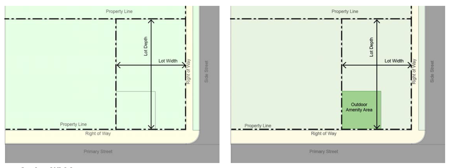
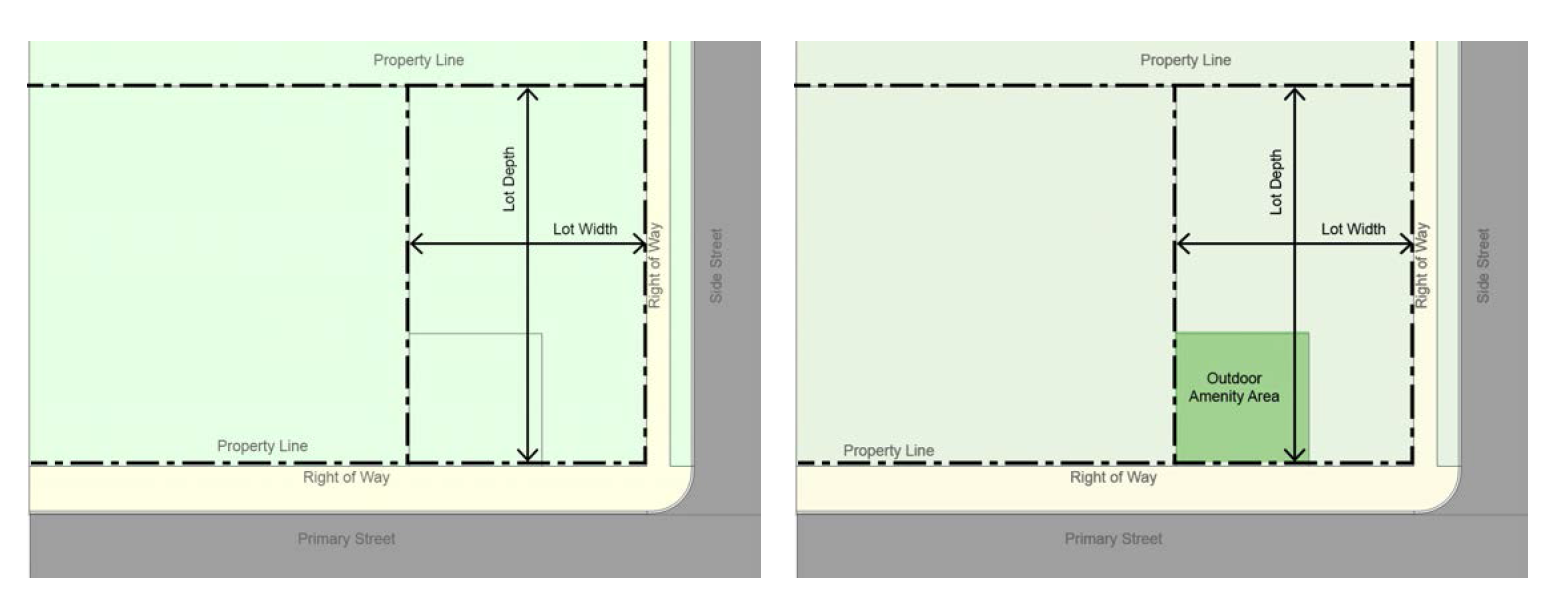
Lot width. The distance between side lot lines measured at right angles to the lot depth at a point from the front lot line equal to the front yard specified for the district.
B.
Lot depth. The mean horizontal distance between the front and rear lot lines, measured in the general direction of the side lot lines.
C.
Outdoor amenity space. Where required, as noted within each subarea, outdoor amenity areas must be provided on the site and must be available as unenclosed, improved active or passive space for use by the occupants of the development. It may be provided in one contiguous open area or multiple areas on the site.
i.
Size and type. Each required outdoor amenity space must be at least 100 square feet in size and may include:
• Playgrounds and athletic court.
• Splash pad.
• Trail or path (minimum ten feet wide).
• Garden, sitting area.
• Rooftop deck.
• Pavilion, gazebo.
• Outdoor dining.
ii.
Other requirements.
• Outdoor amenity areas can include bike racks, kiosks, benches, sculptures, and fountains.
• Outdoor amenity areas cannot be used for parking except for emergency access.
• Outdoor amenity areas must be designed to be permanent.
2.
Building placement.
A.
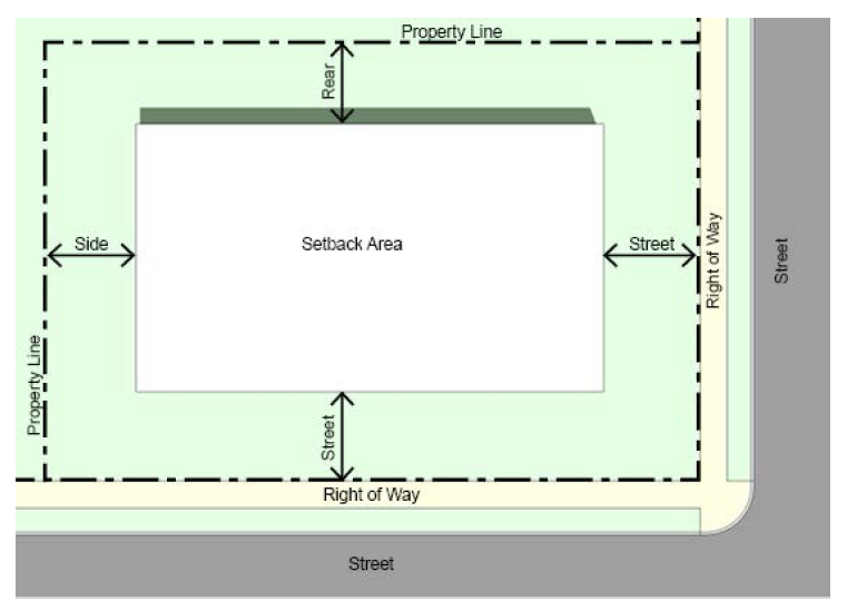
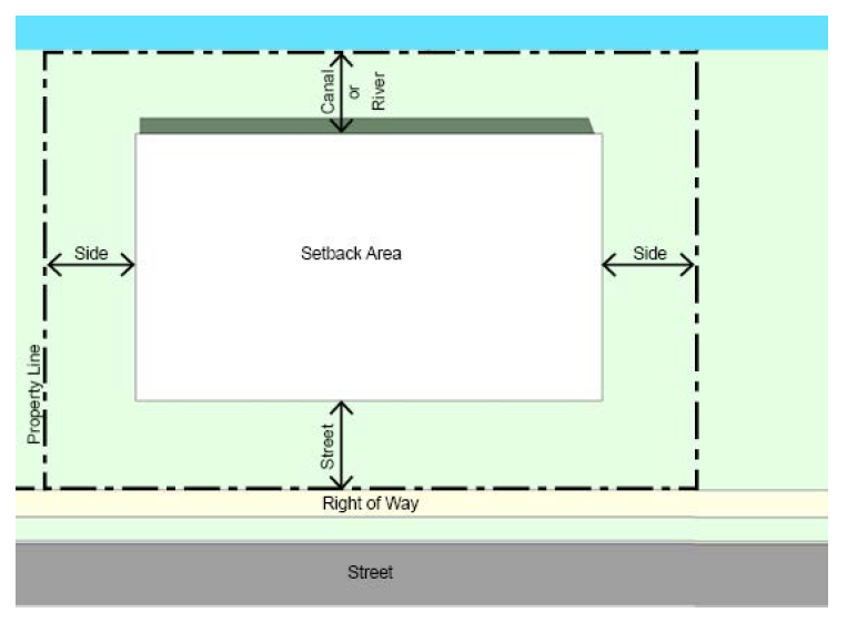
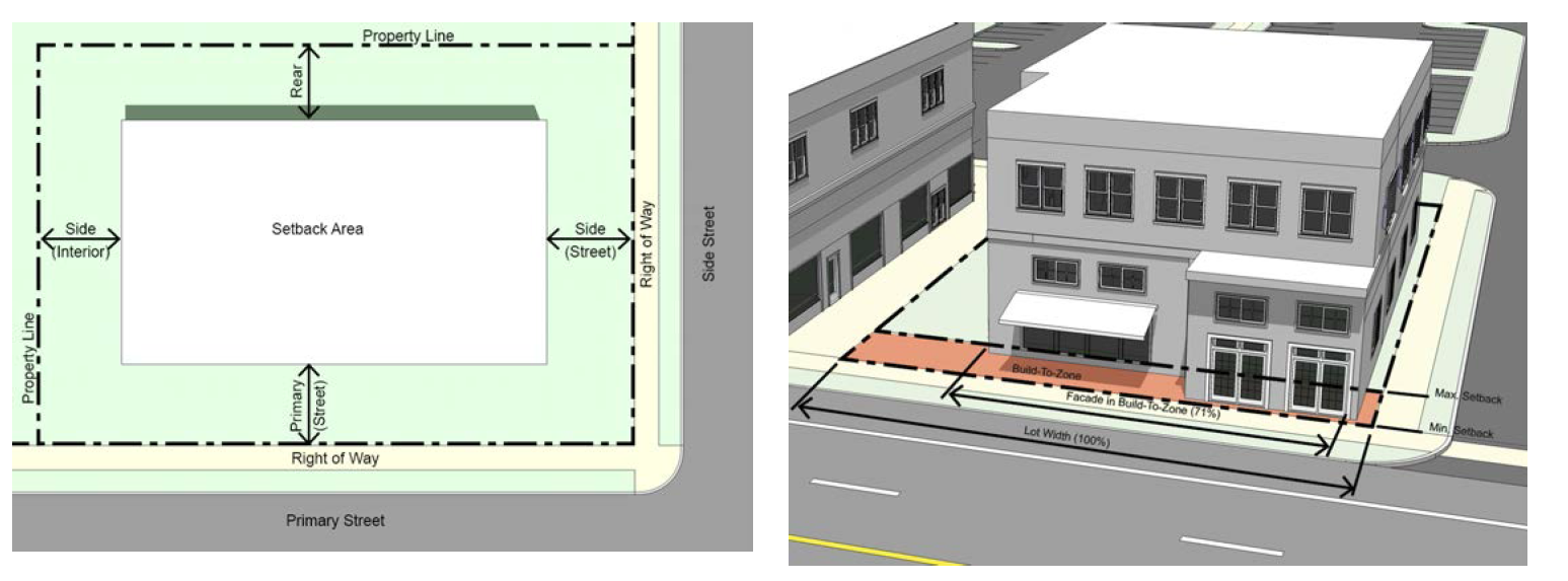
Building setbacks. Building setbacks apply to all structures. There are five types of setbacks and they are measured from the property line:
• Street.
• Side.
• Rear.
• Canal.
• Mohawk River.
B.
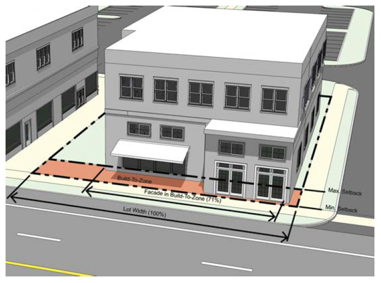
Build-to zone. One of the most important defining elements of the public realm is the street wall. The street wall is made up of building facades that are placed within the build-to zone to create a continuous building fabric. The build-to-zone is the area between the minimum and maximum front setbacks. Portions of a building must be placed within this zone along a prescribed percentage of the lot width.
To determine compliance with the build-to zone requirements, the total width of the building portion located within the build-to zone is divided by the width of the lot.
Build-to zone standards are prescribed in section E regulations pertaining to subareas.
3.
Building height.
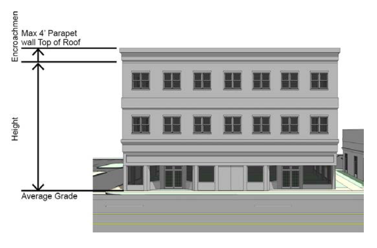
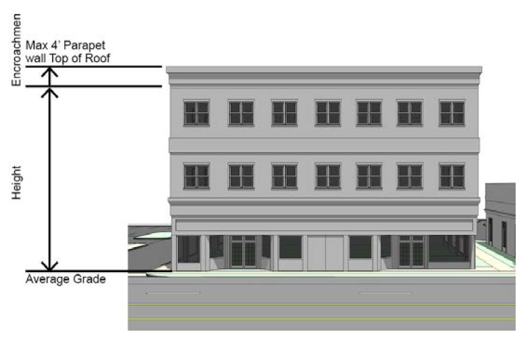
A.
Measurement. Building height is regulated in feet and is measured from the average grade of the frontage facing a primary street to the mean height level between the eaves and ridge of a gable, hip, mansard, or gambrel roof or to the highest point of roof surface of a flat roof, not including allowed encroachments.
B.
Height encroachments. All buildings must be constructed within the maximum building height, with the exception of height encroachments allowed within each subarea. Allowed encroachments are specified in section E., regulations pertaining to subareas.
4.
Facade requirements.
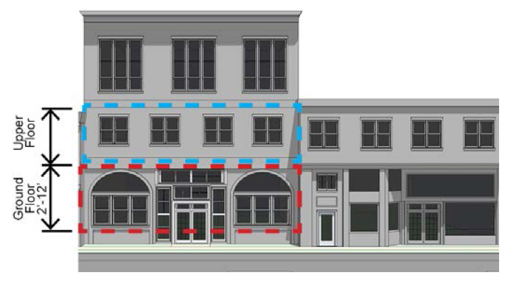
A.
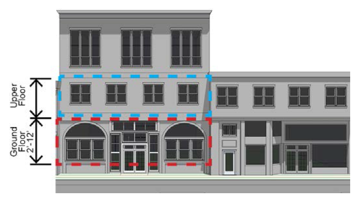
Transparency. Transparency is the minimum percent of street-facing facade that must be comprised of transparent windows. The ground story is measured between two and 12 feet above the sidewalk. This requirement applies to primary and secondary streets only. Opaque elements of a window (such as panes, frosted or tinted areas, and opaque portions of window signs) cannot be used to meet the transparency requirement.
B.
Building materials. Permitted building materials are prescribed within each subarea, as specified in section E., regulations pertaining to subareas.
C.
Pedestrian access. All buildings must provide a street-facing entrance operable to residents or customers at all times. There must be a connection between all main building entrances and the closest sidewalk (or street if there is no sidewalk).
5.
Setback encroachments. All buildings and structures must be located behind the required setback except for the encroachments allowed below.
A.
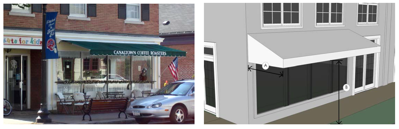
Awnings.
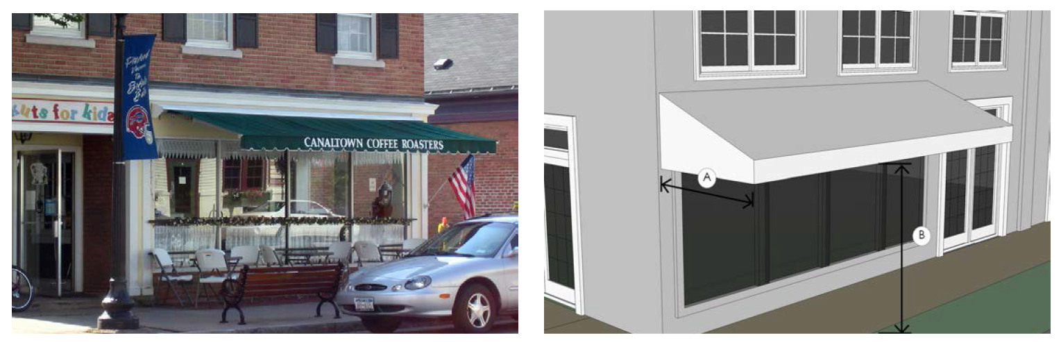
Description. An ornamental roof-like protective cover over a door, entrance, window or outdoor service area that projects from the face of a structure and is constructed of durable materials.
General provisions. Awnings shall be continuous above openings below. Breaks in awnings shall coincide with breaks in facade openings below.
Canvas and fabric awnings must be made of durable fabric.
High-gloss or plasticized fabrics are prohibited.
Awnings should be made of a traditional material (canvas-like), design and color. Traditional colors include black, dark green, navy, and maroon. Vertical stripes are an appropriate option.
Internally illuminated or backlit awnings are prohibited.
Awnings must be self-supporting. No support poles may encroach onto the right-of-way.
Standards.
A.
Depth (max): five feet.
B.
Clear height above sidewalk (min.): seven feet.
Right-of-way permit. All applicants proposing encroachments into the public right-of-way must obtain a right-of-way permit from the department of public works.
B.
Sidewalk dining.
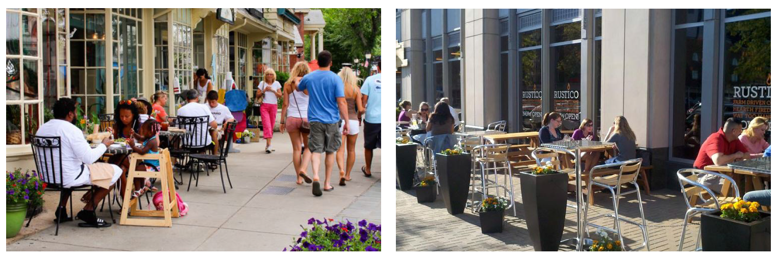
Description. Sidewalk dining is a designated area of a public sidewalk where patrons may sit at tables while consuming food and beverages purchased from the associated eating establishment.
General provisions. The sidewalk dining area must be located adjacent to the property of a lawfully operating eating establishment and shall be under the control of the restaurant.
At least five feet of unobstructed corridor space must be maintained past the sidewalk dining area for sidewalk pedestrian traffic in order to ensure a clear pedestrian passageway along the sidewalk.
At least 44 inches of unobstructed space must be maintained between any restaurant doorway and the sidewalk.
Food preparation is not allowed in the sidewalk dining area.
Loudspeakers are prohibited in the outdoor dining area. Amplified sounds from inside the restaurant must not be audible in any dining area on the public right-of-way.
Railings, fences, and planters. Freestanding planters, fences, or railings may be installed for purposes of compliance with the NYS Liquor Authority and must be:
• Self-supporting.
• No taller than 30 inches.
• Easy to remove from the sidewalk.
If the applicant holds a state liquor authority license to serve alcohol in the restaurant premises, the applicant must provide waiter service.
Right-of-way permit. All applicants proposing encroachments into the public right-of-way must obtain a right-of-way permit from the department of public works.
C.
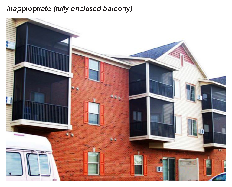
Balconies.
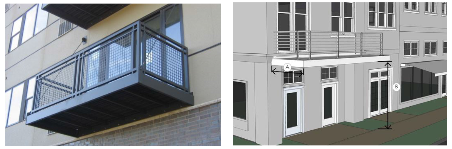
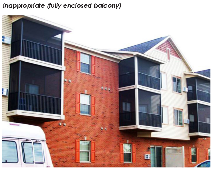
Description. A balcony is an exterior platform that projects from the façade of a building and is surrounded by a railing, handrail, or parapet.
General provisions. Balconies may not be fully enclosed.
Balconies must match the architectural design of the building, using similar details and materials.
Balconies must be self-supporting with no pole extending to the ground.
Standards.
A.
Projecting depth: Six feet.
B.
Clear height above sidewalk (min.): Nine feet.
Right-of-way permit. All applicants proposing encroachments into the public right-of-way must obtain a right-of-way permit from the department of public works.
6.
Vehicle parking regulations.
A.
Minimum spaces required. The minimum parking spaces required is established in article XIV, off-street parking and loading.
B.
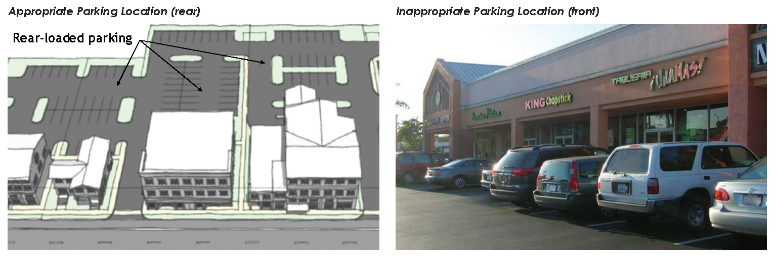
Location of parking. Except where noted in this subsection, off-street vehicle parking is not permitted between a building facade and a front yard lot line. Existing parking areas located between the building facade and a front yard lot line may not be expanded.
C.
Parking lot design. The design of stall size and drive aisle dimensions shall be constructed according to the standards in article XIV off-street parking and loading.
D.
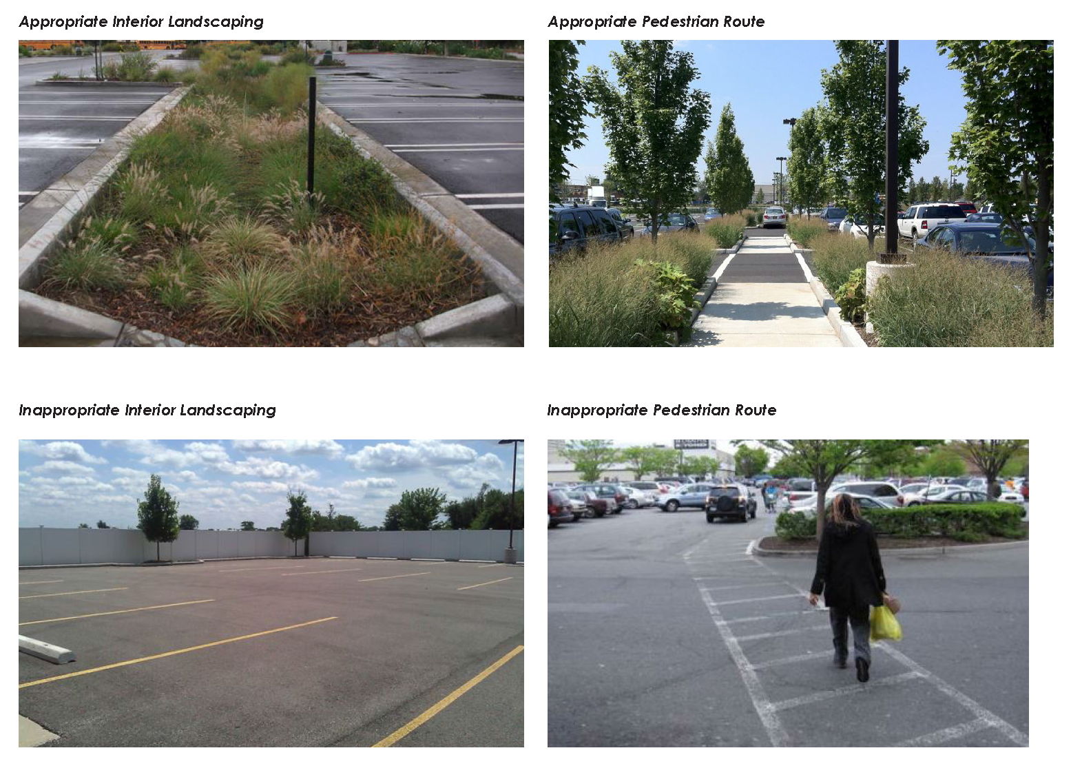
Interior landscaping. Parking lots must meet the requirements in article XIV off-street parking and loading.
E.
Perimeter landscaping. All surface parking lots must be screened according to the requirements set forth in article XV, landscape.
F.
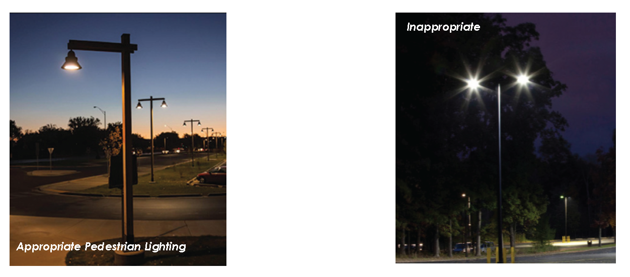
Parking lot lighting. Pedestrian routes must provide pedestrian- scaled lighting that is placed over sidewalks and crossing areas to improve pedestrian comfort and safety. Pedestrian lighting may not exceed 16 feet in height, with a maximum of 60 linear feet between each fixture.
G.
Cross-access and connectivity. Cross-access is encouraged between abutting parking areas.
Property owners who establish cross-access must record an easement allowing cross-access to and from properties served by the access easement and record a joint maintenance agreement defining the maintenance responsibilities of each owner.
Cross-access may be used to justify a reduction in the required minimum parking when proposed as part of a joint parking agreement.
H.
Loading areas. Loading areas must be located on the lot occupied by the use served and must be accessible from a public street or alley.
Loading areas may not be placed between the building and any front yard lot line.
I.
Shared parking. Applicants are encouraged to investigate common or shared parking opportunities between adjacent uses and businesses.
Where shared parking is used to meet the requirements for a reduction in the total number of required parking spaces, the applicant must provide the city with a joint parking agreement. Shared parking must be within 600 feet of the pedestrian entrances of all establishments involved in the joint parking agreement.
J.
Internal pedestrian routes. Internal pedestrian routes must be provided between different areas within the site, such as parking areas, bicycle parking, common outdoor areas, and any pedestrian routes.
Pedestrian routes must be hard surfaced at least five feet in width. Where the route crosses driveways, parking and loading areas, the route must be clearly identifiable through the use of elevation changes, paving materials or other methods.
7.
Screening.
A.
Screening.
i.
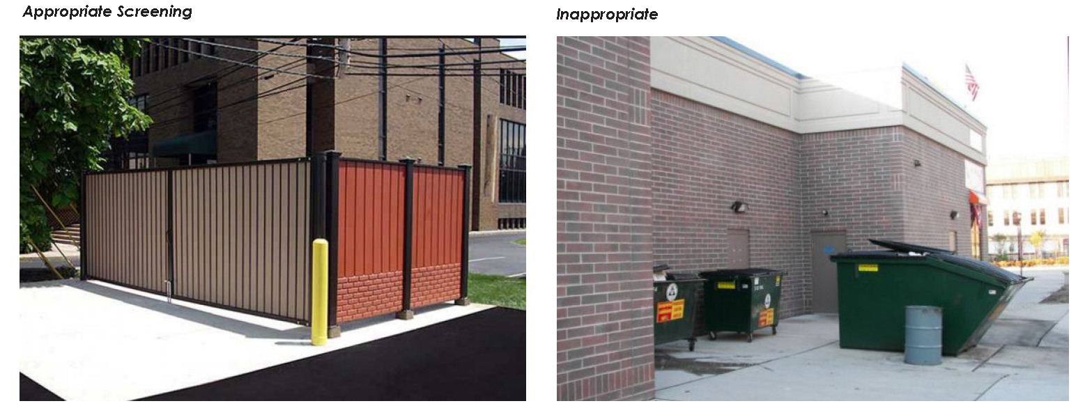
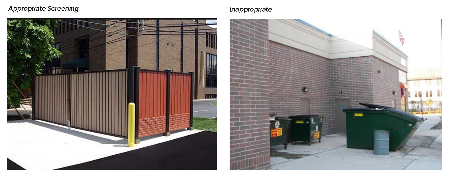
Service areas. Trash collection, recycling, compaction, and other similar service areas must be located to the side or rear of buildings and must be screened from view from adjacent properties and from a public right-of-way (not including alleys).
Service areas that are not integrated into a building must be screened on at least three sides by a wall at least six feet high and on the fourth side by a solid gate at least six feet high.
ii.
Roof mounted equipment. Roof mounted equipment, at ground level, must be screened from ground level view from adjacent property and adjacent public rights-of-way.
iii.
Wall mounted equipment. Wall mounted equipment must be screened by landscaping or an opaque screen and is not allowed on any surface that directly faces a front or side yard lot line.
iv.
Ground mounted equipment. Ground mounted equipment must be screened from view by landscaping or a fence or wall that is equal to or greater than the height of the equipment.
B.
Fences and walls.
i.
Height.
• Fences and walls screening service areas and ground mounted equipment may be no higher than eight feet.
• Fences in all other permitted areas may be no higher than six feet.
ii.
Materials.
• Walls and fences must be constructed of high quality materials, such as decorative blocks, brick, stone, split- faced block, wood, or other materials consistent with the associated building.
• Exposed standard concrete walls are prohibited.
• Barbed wire, concertina, and chain-link fences are prohibited.
8.
Site landscaping.
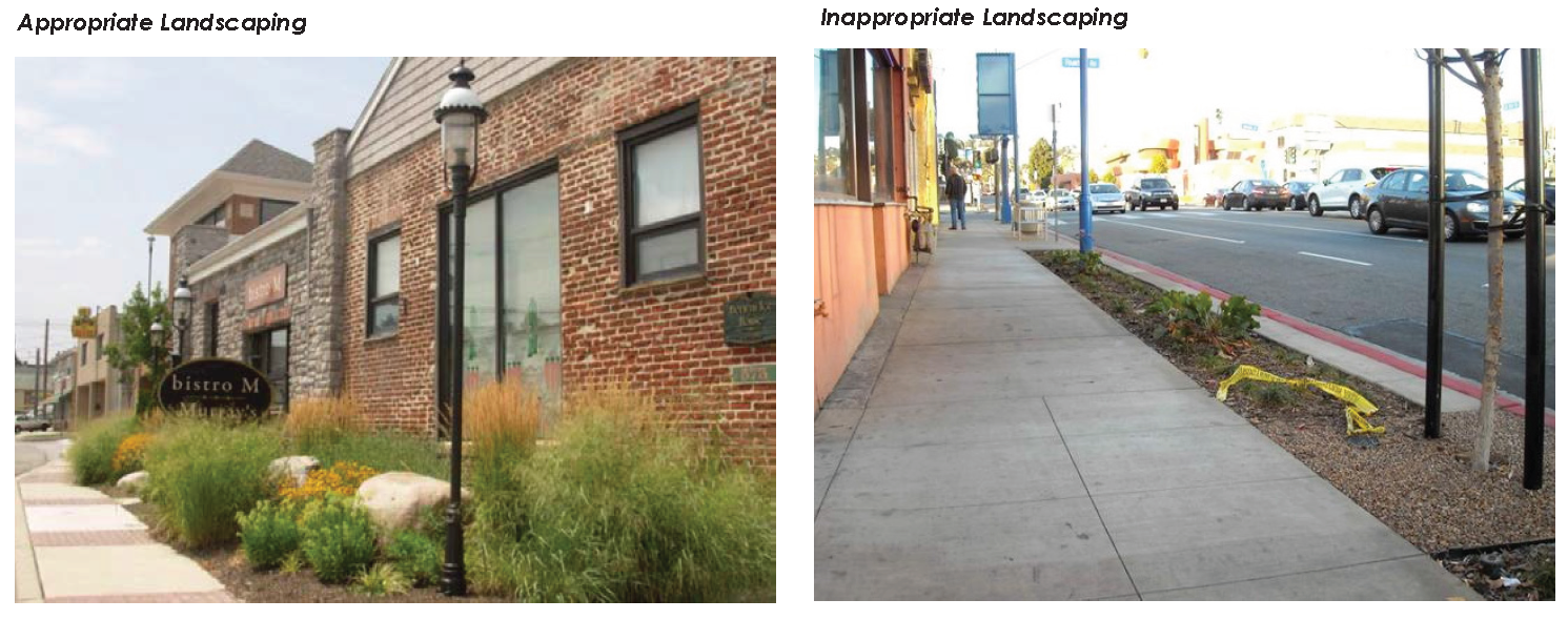
A.
General requirements. Applications required to meet the landscaping standards in this section (see applicability matrix) must provide landscaping within portions of property that are not developed with structures, rights-of-way, or parking areas.
B.
Planting and maintenance standards. The planting and maintenance of landscaping in the waterfront district must meet the requirements prescribed in the Rome Zoning Ordinance, article XV, landscape.
9.
Lighting regulations.
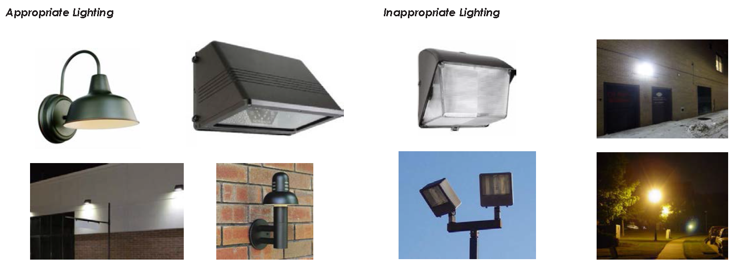
A.
Lighting.
i.
Prohibited sources/fixtures.
• Cobra-head style fixtures having dished or drop lenses or refractors.
• Temporary search lights and other high intensity, narrow beam lights.
• Amber hue lighting, such as high pressure sodium fixtures and equivalent performance are not permitted.
ii.
Building lighting.
• Building mounted lighting must be complementary to the architectural style of the building and surroundings.
• Building lighting may not be installed at a height exceeding 15 feet above grade.
• Exterior building light fixtures must be full cutoff.
iii.
Site lighting.
• Site lighting fixtures must be complementary to the architectural style of the building and surroundings.
• Site lighting fixtures must be full cutoff. Light trespass into adjacent non-commercial areas shall not exceed 0.1 foot-candles in intensity.
• Fixtures within pedestrian areas, along sidewalks and walkways may be no higher than 12—15 feet.
• Fixtures within parking lots may be no higher than 20 feet.
10.
General provisions for signs.
A.
Applicability. See article XVI, signs.
E.
Regulations pertaining to subareas. The following regulations shall apply to property within each corresponding subarea.
1.
WD—Canal.
Intent of the WD-1 canal is to accommodate a mix of residential and commercial uses in buildings that do not exceed six stories.
Special focus is placed on creating a vibrant, walkable area that prioritizes public access to the waterfront.
2.
WD—Industrial.
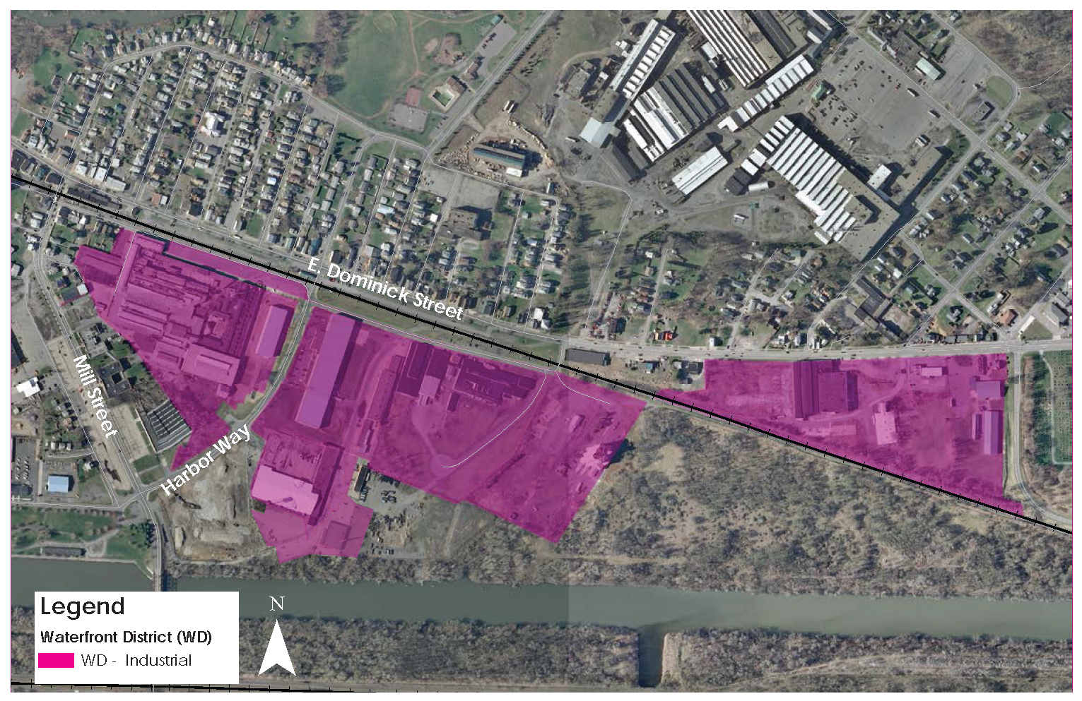
The intent of the WD-2 district is to encourage job creation and residential uses that are compatible with surrounding areas. The district promotes economic development and job creation by encouraging uses such as light industrial, research and manufacturing, niche industry, green industry, and redevelopment of warehouses. The district is intended to become a future gateway to the city's waterfront and an important link between the Erie Canal and East Dominick neighborhoods.

3.
WD—Mohawk River.
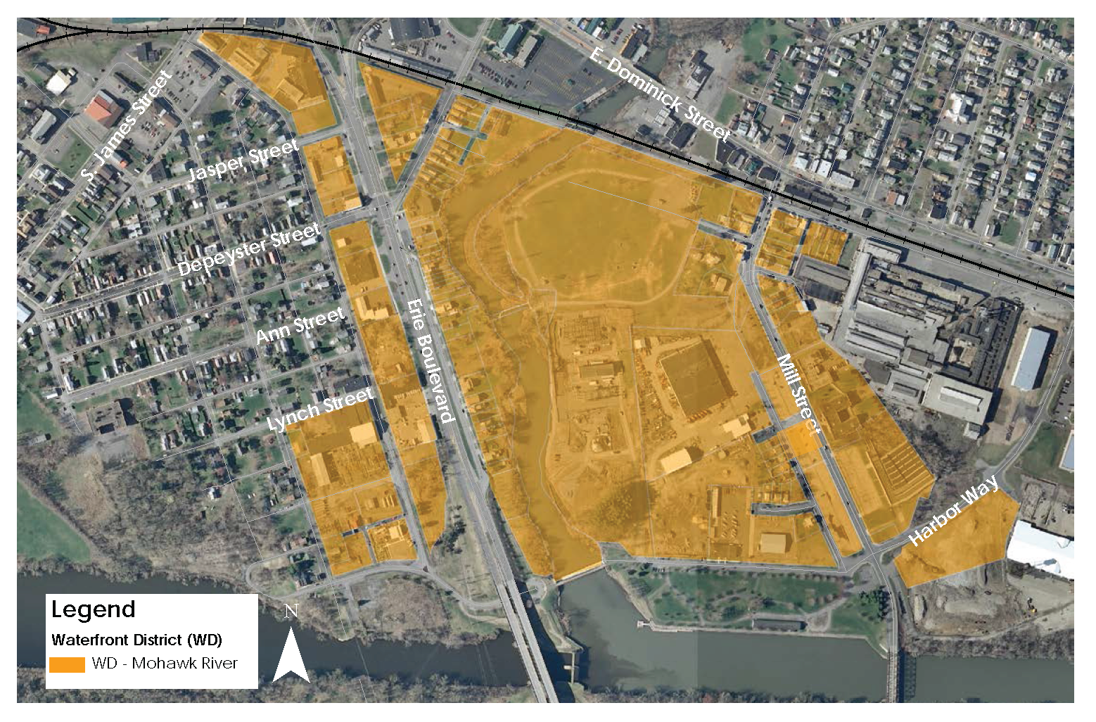
The intent of the WD-3 district is to facilitate potential recreational uses and small-scale mixed-use commercial buildings that provide a strong linkage between the waterfront, Bellamy Harbor Park, surrounding light industrial uses, and Downtown Rome.
F.
Subarea Standards Matrix.
G.
Application review.
1.
Applicability. Development applications on parcels within the waterfront district must comply with the approval requirements of this subsection.
2.
Environmental review. Development applications on parcels within the waterfront district are subject to review under SEQR, in accordance with Rome Zoning Code article VI, environmental review.
3.
Pre-application conference. Prior to submission of a development application, the applicant is encouraged to schedule a pre-application conference with the planning department to discuss application procedures, standards, and regulations of this subsection.
A request for a pre-application conference by a potential applicant must be accompanied by preliminary project plans in hard copy format no smaller than 11 x 17. The request must also include a cover letter describing the project, including the parcel number(s) and address of the proposed site, the proposed land uses, the square footage(s), height(s) and character of the proposed development.
4.
Application requirements. For proposals subject to compliance with requirements set forth in the waterfront district, an application for approval must submitted in accordance with the site plan checklist requirements prescribed by Rome Code Zoning Code section 80-19.4, application for site plan approval.
5.
Completeness review. The planning department will review the submitted materials for completeness and, within ten business days, either accept the application as complete or request further information from the applicant.
6.
Administrative review. Upon acceptance of a complete application, the planning department will, within 30 days, review the application for consistency with the requirements of this section and forward the application to the appropriate city departments and, if necessary, local agencies (ex. county 239 review) for review and recommendation.
Upon receipt of department and agency comments, the planning department must make an initial determination of compliance with the requirements of this section and any applicable requirements of the city's zoning code, and prepare a written staff report.
7.
Administrative approval. Applications that comply with all standards of this section and fall within the thresholds listed below may be processed and approved by the planning director or designee.
Administrative approval thresholds.
Multi-family residential uses:
1.
New multi-family up to four units or multi-family conversions up to four units.
2.
Expansion of existing structures by less than 30 percent or more of current square footage.
Non-residential uses:
1.
Non-residential or mixed-use development of less than 4,000 square feet.
2.
Expansion of less than 30 percent of the current gross square footage.
Parking lots, parking structures, loading and stacking area:
1.
Any new parking lot or parking structure with less than 20 spaces.
2.
Expansion of a parking lot, parking structure, loading or stacking areas by less than 30 percent of total area. Changes to parking lots, parking structures, loading or stacking areas may require planning board approval at the discretion of the planning director.
Applications that exceed the thresholds listed above are subject to planning board approval.
8.
Planning board approval. The planning board may approve applications that do not comply with the standards of the waterfront district, if the proposal is substantially consistent with the criteria in this subsection.
The planning board may request comments from the public to make a determination to approve, approve subject to conditions, or disapprove the application.
i.
Planning board approval criteria. The criteria herein must be used by the planning board in reviewing applications subject to site plan review, including all buildings, structures, signs, and other site features:
• The purpose, intent, and design objectives of the waterfront district are met.
• The proposal is compatible with the surrounding properties.
• The proposal minimizes impacts of noise, light, debris, and other undesirable effects upon abutting properties and the abutting district or subarea as a whole.
• Loading and refuse areas are adequately screened such that they are not visible from adjacent rights-of-way and abutting properties.
• Ingress, egress, internal circulation, off-street parking, loading/service areas are designed to promote safety, convenience, and provide a high quality pedestrian environment.
• Signage is designed to provide compatibility with building form, shape and color.
ii.
Exceptions. This section does not authorize the planning board to approve the following in the waterfront district:
• Electronic message boards.
• A use prohibited by this section.

(Ord. No. 9301A, 9-26-18)
Sec. 80-9.2. - Woodhaven Redevelopment District.
A.
Introduction. This section provides regulatory standards governing land use and building form within the Woodhaven Redevelopment District. The form- based code is a reflection of the community's vision for Woodhaven and implements the intent of the Woodhaven Revitalization Plan.
The form-based code is intended for adoption as part of the City of Rome Zoning Ordinance.
Upon adoption, it will supersede and replace existing zoning provisions regarding zoning districts, allowable land uses, permit requirements, and site development standards.
1.
Purpose and intent. The purpose of the Woodhaven Redevelopment District is to create a dynamic, sustainable and attractive mixed-use neighborhood with a focus on recreation. The Woodhaven Redevelopment District will harmonize single-family, two-family, multiple-unit, and mixed-use structures to attract a broad spectrum of families, professionals, retirees, and students. In the context of a multiple-use, intermodal Greenbelt concept, this district will connect to existing municipal streets, sidewalk, and trails in the surrounding neighborhoods and prioritize the preservation and enhancement of natural resources, urban trees, and public greenspaces along the Mohawk River area to maximize the environmental, financial, and social benefits. The redevelopment of this area will also serve to prioritize and enhance the physical connection to the Rome Free Academy High School, and the Griffiss Business and Technology Park.
2.
Applicability. The provisions in this section shall apply to all development of property within the Woodhaven Redevelopment District.
3.
Conflicting provisions. In the event that this section conflicts with any other provision of the Rome Zoning Code or the attached appendices, the provision of this section shall supersede, except that where this section is silent, the Rome Zoning Code or the attached appendices shall apply.
B.
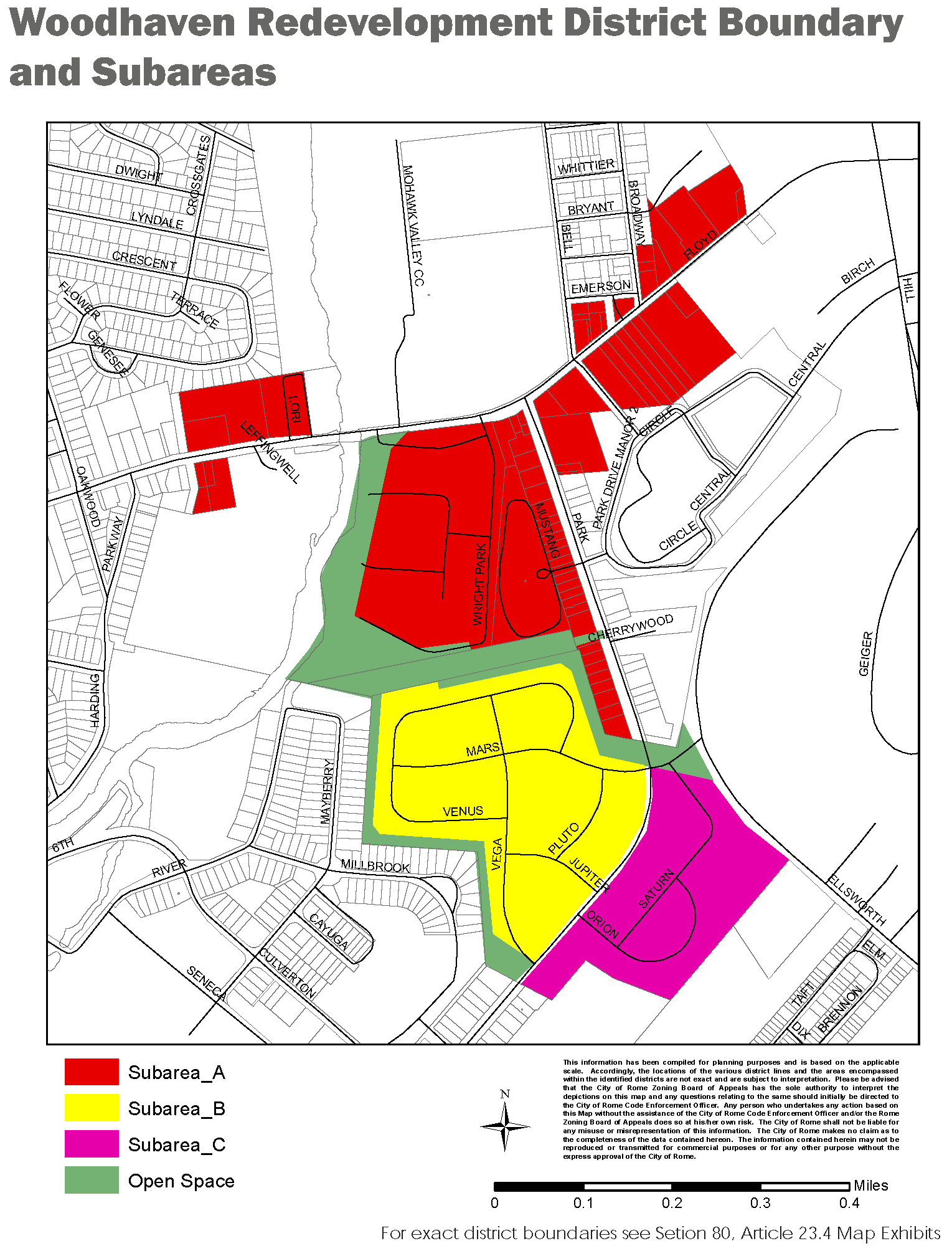
Subareas established. The Woodhaven Redevelopment District is hereby divided into subareas as shown here which is hereby made part of this ordinance.
• Subarea A—Mixed-use commercial and residential.
• Subarea B—Single-family residential.
• Subarea C—Mid-density campus.
• Subarea D—Buffer/open space.
The subareas have been organized based upon the Woodhaven Revitalization Plan preferred master plan.
C.
Use regulations. [2] Uses permitted within the Woodhaven Redevelopment District subareas are those listed in sub-section F.
D.
Regulations applicable to all. The following standards apply to all sites and buildings in all subareas unless expressly stated otherwise.
Applications must conform to the provisions set forth in the Rome Zoning Code, including but not limited to articles XII through XVI (uses, development standards, off-street parking and loading, landscape, and signs), and any additional provisions noted in this section.
1.
Site requirements.
A.
Lot width. The distance between side lot lines measured at right angles to the lot depth at a point from the front lot line equal to the front yard specified for the district.
B.
Lot depth. The mean horizontal distance between the front and rear lot lines, measured in the general direction of the side lot lines.
C.
Outdoor amenity space. Where required, as noted within each subarea, outdoor amenity areas must be provided on the site and must be available as unenclosed, improved active or passive space for use by the occupants of the development. It may be provided in one contiguous open area or multiple areas on the site.
i.
Size and type. Each must be at least 100 square feet in size and may include:
• Playgrounds and athletic court.
• Splash pad.
• Trail, path (minimum ten feet wide).
• Garden, sitting area.
• Rooftop deck.
• Pavilion, gazebo, greenhouse.
• Outdoor dining.
ii.
Other requirements.
• Outdoor amenity areas can include bike racks, kiosks, benches, sculptures, and fountains.
• Outdoor amenity areas cannot be used for parking except for emergency access.
• Outdoor amenity areas must be designed to be permanent.
2.
Building placement.
A.
Building setbacks. Building setbacks apply to all structures, refer to sub-section F., regulations pertaining to subareas.
Measurement of setbacks. Primary and secondary street setbacks are measured from the property line. Side, rear, and interior setbacks are measured from the property line (or edge of right-of-way where there is an alley).
B.
Build-to zone. One of the most important defining elements of the public realm is the street wall. The street wall is made up of building facades that are placed within the build-to zone to create a continuous building fabric. The build-to-zone is the area between the minimum and maximum front setbacks. Portions of a building must be placed within this zone along a prescribed percentage of the lot width.
To determine compliance with the build-to zone requirements, the total width of the building portion located within the build-to zone is divided by the width of the lot.
Build-to zone standards are prescribed in sub-section F., regulations pertaining to subareas.
3.
Building height.
A.
Measurement. Building height is regulated in feet and is measured from the average grade of the frontage facing a primary street to the mean height level between the eaves and ridge of a gable, hip, mansard, or gambrel roof or to the highest point of roof surface of a flat roof, not including allowed encroachments.
B.
Height encroachments. All buildings must be constructed within the maximum building height, with the exception of height encroachments allowed within each subarea. Allowed encroachments are specified in sub-section F., regulations pertaining to subareas.
4.
Facade requirements.
A.
Transparency. Transparency is the minimum percent of street-facing facade that must be comprised of transparent windows. The ground story is measured between two and 12 feet above the sidewalk. This requirement applies to primary and secondary streets only. Opaque elements of a window (such as panes, frosted or tinted areas, and opaque portions of window signs) cannot be used to meet the transparency requirement.
B.
Building materials. Permitted building materials are prescribed within each subarea, as specified in sub-section E., regulations pertaining to subareas.
C.
Pedestrian access. All buildings must provide a street-facing entrance operable to residents or customers at all times. There must be a connection between all main building entrances and the closest sidewalk (or street if there is no sidewalk).
5.
Setback encroachments. All buildings and structures must be located behind the required setback except for the encroachments allowed below.
A.
Awnings.
Description. An ornamental roof-like protective cover over a door, entrance, window or outdoor service area that projects from the face of a structure and is constructed of durable materials.
General provisions. Awnings shall be continuous above openings below. Breaks in awnings shall coincide with breaks in facade openings below.
Canvas and fabric awnings must be made of durable fabric.
High-gloss or plasticized fabrics are prohibited.
Awnings should be made of a traditional material (canvas-like), design and color. Traditional colors include black, dark green, navy, and maroon.
Vertical stripes are an appropriate option.
Internally illuminated or backlit awnings are prohibited.
Awnings must be self-supporting. No support poles may encroach onto the right-of-way.
Standards.
A.
Depth (max): Five feet.
B.
Clear height above sidewalk (min.): Seven feet.
Right-of-way permit. All applicants proposing encroachments into the public right-of-way must obtain a right-of-way permit from the department of public works.
B.
Balconies.

Description. A balcony is an exterior platform that projects from or into the façade of a building and is surrounded by a railing, handrail, or parapet.
General provisions. Balconies may not be fully enclosed.
Balconies must match the architectural design of the building, using similar details and materials.
Standards.
A.
Projecting depth (max): Six feet
B.
Clear height above sidewalk (min.): Nine feet
Right-of-way permit. All applicants proposing encroachments into the public right-of-way must obtain a right-of-way permit from the department of public works.
6.
Screening.
A.
Screening.
i.
Service areas. Trash collection, recycling, compaction, and other similar service areas must be located to the side or rear of buildings and must be screened from view from adjacent properties and from a public right-of-way (not including alleys).
Service areas that are not integrated into a building must be screened on at least three sides by a wall at least six feet high and on the fourth side by a solid gate at least six feet high.
ii.
Roof mounted equipment. Roof mounted equipment must be screened from ground level view from adjacent property and adjacent public rights-of-way.
iii.
Wall mounted equipment. Wall mounted equipment must be screened by landscaping or an opaque screen and is not allowed on any surface that directly faces a front or side yard lot line.
iv.
Ground mounted equipment. Ground mounted equipment must be screened from view by landscaping or a fence or wall that is equal to or greater than the height of the equipment.
B.
Fences and walls.
i.
Height. Fences and walls required pursuant to this subsection may be no higher than eight feet.
ii.
Materials.
• Walls and fences must be constructed of high quality materials, such as decorative blocks, brick, stone, split- faced block, or other materials consistent with the associated building.
• Exposed standard concrete walls are prohibited.
• Barbed wire, concertina, and chain-link fences are prohibited.
7.
Lighting regulations.
A.
Lighting.
i.
Prohibited sources/fixtures.
• Cobra-head style fixtures having dished or drop lenses or refractors.
• Temporary search lights and other high intensity, narrow beam lights.
• Amber hue lighting, such as high pressure sodium fixtures and equivalent performance are not permitted.
ii.
Building lighting.
• Building mounted lighting must be complementary to the architectural style of the building and surroundings.
• Building lighting may not be installed at a height exceeding 15 feet above grade.
• Exterior building light fixtures must be full cutoff.
iii.
Site lighting.
• Site lighting fixtures must be complementary to the architectural style of the building and surroundings.
• Site lighting fixtures must be full cutoff. Light trespass into adjacent non-commercial areas shall not exceed 0.1 foot-candles in intensity.
• Fixtures within pedestrian areas, along sidewalks and walkways may be no higher than eight feet.
• Fixtures within parking lots may be no higher than 20 feet.
E.
Regulations pertaining to subareas. The following regulations shall apply to property within each corresponding subarea.
Subarea A—Mixed Use Commercial and Residential.
The northern area is defined by +30-acre parcel fronting Floyd Avenue and the Mohawk River (north of the electrical transmission right-of-way), and includes the Floyd Avenue commercial corridor from just west of the Mohawk River bridge stretching to Griffiss Business and Technology Park; where the plan prescribes mixed-uses including commercial, residential, and recreation. The multi-story buildings on the 30 acre parcel should front on Floyd Avenue, extending the existing commercial corridor and paying close attention to the streetscape aesthetic. Proposed buildings should extend along the Woodhaven entrance drive as much as practical to pull the streetscape aesthetic interior to the site. The western building should, ideally, interact with the Mohawk River, engaging the public riverfront and trail. Commercial activities should be encouraged to spill outside the building by providing semi-private patios and outdoor spaces that maximize the interplay of humans and nature. Pedestrian connections and outdoor amenities are vital components of any site plan proposed for the northern section.
The multi-family housing in this area should be laid out with a walkable concept including pedestrian connections to the Mohawk River Trail and the proposed commercial uses.
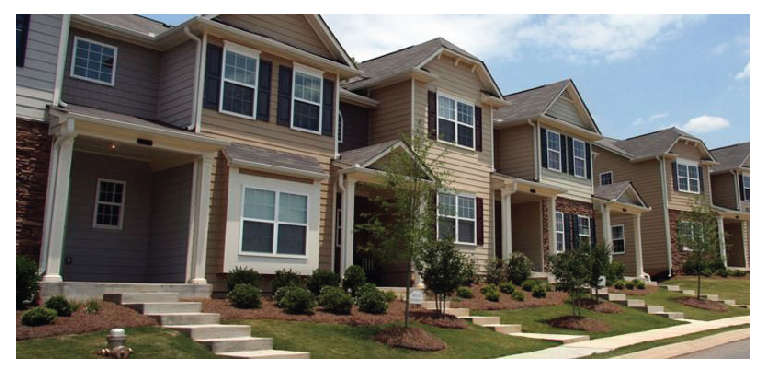
Subarea B—Single-Family Residential.
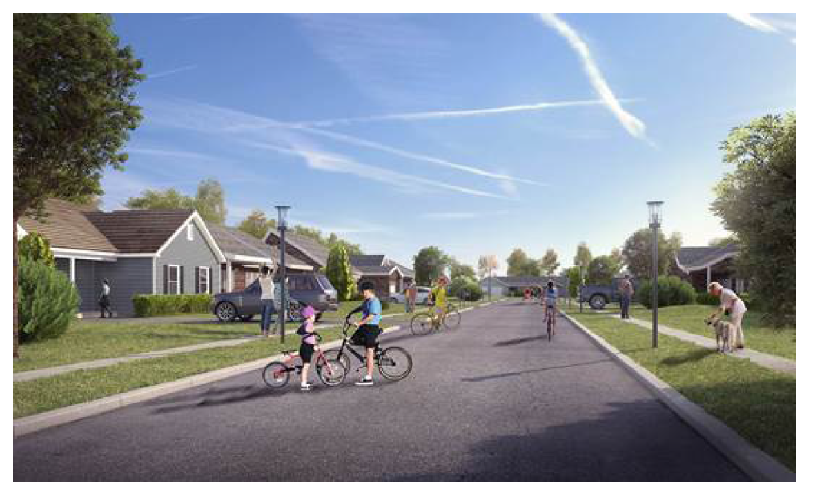
The central area, between the overhead electrical transmission lines and the realigned Park Drive, provides for flexibility to potential developers. This subarea provides a balance between the community's desire for single-family housing with the desire for natural or open space areas and trails. This subarea allows for flexibility to subdivide or sell acreage as the market demands. The style of this development within this subarea should include small lots consistent with lot sizes in the adjacent neighborhoods. Sidewalks and trail spurs must be included to enhance pedestrian and bicycle connectivity and accessibility for the mobility impaired.
Subarea C—Mid-Density Campus.
The southern area, southeast of Park Drive, is comprised of moderate density residential allowing for townhomes and apartments. This area could be proposed as a senior living community or be open to a broad spectrum of residents. Uses could include low maintenance properties, access to sidewalks and trails, safe and well-lit open spaces, and accessibility to minor conveniences (i.e., coffee shop, small retail). Sidewalks and trails should connect within and to the adjacent neighborhoods.
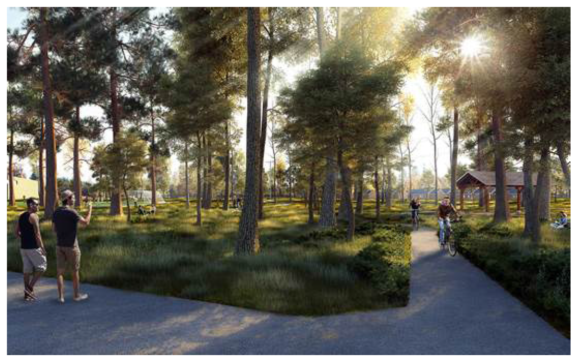
Subarea Buffer and Open Space.
The buffer and open space areas shall be owned and controlled by the City of Rome. This subarea should include augmenting the urban canopy and preserving the continuity of natural areas. Further this subarea should provide circulation for non-motorized users and act as a "greenbelt."
F.
Woodhaven subareas permitted use matrix.
G.
Subarea standards matrix.
H.
Application review.
1.
Applicability. Development applications within the Woodhaven Redevelopment District must comply with the approval requirements of this subsection.
2.
Environmental review. Development applications on parcels within the Woodhaven Redevelopment District are subject to review under SEQR, in accordance with Rome Zoning Code section 80-9.10, environmental quality review.
3.
Pre-application conference. Prior to submission of a development application, the applicant is encouraged to schedule a pre-application conference with the planning department to discuss application procedures, standards, and regulations of this subsection.
A request for a pre-application conference by a potential applicant must be accompanied by preliminary project plans in hard copy format no smaller than 11 x 17. The request must also include a cover letter describing the project, including the parcel number(s) and address of the proposed site, the proposed land uses, the square footage(s), height(s) and character of the proposed development.
4.
Application requirements. For proposals subject to compliance with requirements set forth in the Woodhaven Redevelopment District, an application for approval must submitted in accordance with the site plan checklist requirements prescribed by Rome Code Zoning Code Section 80-19.4, application for site plan approval.
5.
Completeness review. The planning department will review the submitted materials for completeness and, within ten business days, either accept the application as complete or request further information from the applicant.
6.
Administrative review. Upon acceptance of a complete application, the planning department will, within 30 days, review the application for consistency with the requirements of this section and forward the application to the appropriate city departments and, if necessary, local agencies (ex. county 239 review) for review and recommendation.
Upon receipt of department and agency comments, the planning department must make an initial determination of compliance with the requirements of this section and any applicable requirements of the city's zoning code, and prepare a written staff report.
7.
Administrative approval. Applications that comply with all standards of this section and fall within the thresholds listed below may be processed and approved by the planning director or designee.
Administrative approval thresholds
Multi-family residential uses:
1.
New multi-family up to four units or multi-family conversions up to four units.
2.
Expansion of existing structures by less than 30 percent or more of current square footage.
Non-residential uses:
1.
Non-residential or mixed-use development of less than 4,000 square feet.
2.
Expansion of less than 30 percent of the current gross square footage.
Parking lots, parking structures, loading and stacking area:
1.
Any new parking lot or parking structure with less than 20 spaces.
2.
Expansion of a parking lot, parking structure, loading or stacking areas by less than 30 percent of total area. Changes to parking lots, parking structures, loading or stacking areas may require planning board approval at the discretion of the planning director.
Applications that exceed the thresholds listed above are subject to planning board approval.
8.
Planning board approval. The planning board may approve applications that do not comply with the standards of the Woodhaven Redevelopment District, if the proposal is substantially consistent with the criteria in this subsection.
The planning board may request comments from the public to make a determination to approve, approve subject to conditions, or disapprove the application.
i.
Planning board approval criteria. The criteria herein must be used by the planning board in reviewing applications subject to site plan review, including all buildings, structures, signs, and other site features:
• The purpose, intent, and design objectives of the Woodhaven Redevelopment District are met.
• The proposal is compatible with the surrounding properties.
• The proposal minimizes impacts of noise, light, debris, and other undesirable effects upon abutting properties and the abutting district or subarea as a whole.
• Loading and refuse areas are adequately screened such that they are not visible from adjacent rights-of-way and abutting properties.
• Ingress, egress, internal circulation, off-street parking, loading/service areas are designed to promote safety, convenience, and provide a high quality pedestrian environment.
• Signage is designed to provide compatibility with building form, shape and color.
ii.
Exceptions. This section does not authorize the planning board to approve the following in the Woodhaven Redevelopment District:
• Electronic message boards.
• A use prohibited by this section.
(Ord. No. 9301A, 9-26-18; Ord. No. 9563A, 1-25-23)
Editor's note— As defined in the Rome Zoning Code.