
Rome City Zoning Code
ARTICLE III
- DEFINITIONS AND RULES OF MEASUREMENT
Sec. 80-3.1. - Rules of interpretation.
The terms in the text of this code must be interpreted in accordance with the following rules of construction:
(a)
The singular number includes the plural, and the plural the singular.
(b)
The present tense includes the past and future tenses, and the future tense includes the present.
(c)
The terms "must," "shall," and "will" are mandatory, while the word "may" is permissive.
(d)
The terms "must not," "will not," "shall not," "cannot," and "may not" are prohibiting.
(e)
Any gender includes all genders.
(f)
Whenever a defined word or term appears in the text of this code, its meaning must be construed as set forth in the definition. Words not defined must be interpreted in accordance with the definitions considered to be normal dictionary usage.
(Ord. No. 9301A, 9-26-18)
Sec. 80-3.2. - Definition of general terms.
The principal uses and temporary uses within the use matrix of article XII of this code are defined in section 80-12.5. The terms defined in this section are general terms used throughout the code.
ANSI. American National Standards Institute or its successor bodies.
A-weighted sound pressure level. The sound pressure level as measured with a sound level meter using the A-weighting network, used to approximate the average human ear response to a range of sound frequencies.
Abandonment. An intent to abandon or to relinquish which may be demonstrated by some overt act, or some failure to act which carries the implication that the owner neither claims nor retains any interest in the subject matter of the abandonment.
Abut. To share a common boundary such as a common wall or lot line without being separated by a street or alley.
Access. A way or means of approach to provide vehicular or pedestrian physical entrance to a property.
Accessibility ramp. A ramp or similar structure that provides wheelchair or similar access to a structure.
Accessory structure. A structure located on the same lot as the principal building, which may be detached or attached, that is incidental to the use of the principal building.
Accessory use. A use of land or a structure, or portion thereof, customarily incidental and subordinate to the principal use of the land or structure. An accessory use is prohibited without the principal use to which it is related.
Addition/enlargement. Construction that increases the size of a structure in terms of building footprint, height, or floor area.
Adjacent. To be separated only by a common wall or lot line.
Adjoining. See adjacent.
Alley. A public right-of-way that normally affords a secondary means of access to abutting property.
Alteration. As applied to a building or structure, any change or rearrangement in the structural parts or in the exit facilities or any enlargement, either by extending a side or by increasing in height, or the moving from one location or position to another.
Amateur (HAM) radio equipment. An amateur (HAM) radio station licensed by the Federal Communications Commission (FCC), including equipment such as, but not limited to, a tower or building-mounted structure supporting a radiating antenna platform and other equipment.
Amendment. A change to any portion of this zoning code that includes revisions to the zoning text and/or the official zoning map. The authority for any amendment lies solely with the city council.
Ancillary. In regard to principal uses, a structure or use that provides support and/or is typically integral to a principal structure or use.
Apiary. A structure for the keeping of honeybees.
Aquaculture/aquaponics. A structure designed for the farming of aquatic organisms such as fish, crustaceans, mollusks, and aquatic plants under controlled conditions.
Architectural feature. A part or projection that contributes to the aesthetics of a structure, exclusive of signs, that is not necessary for the structural integrity of the structure or to make the structure habitable.
Area of shallow flooding. A designated AO, AH or VO zone on a community's flood insurance rate map (FIRM) with a one percent or greater annual chance of flooding to an average annual depth of one to three feet where a clearly defined channel does not exist, where the path of flooding is unpredictable, and where velocity flow may be evident. Such flooding is characterized by ponding or sheet flow.
Area of special flood hazard. The land in the floodplain within a community subject to a one percent or greater chance of flooding in any given year. This area may be designated as zone A, AE, AH, AO, A1-A30, A99, V, VO, VE, or V1-V30. It is also commonly referred to as the base floodplain or l00-year floodplain. For purposes of this code, the term special flood hazard area (SFHA) is synonymous in meaning with the phrase area of special flood hazard.
Area variance. Authorization for the development of land in a manner that is not allowed by the dimensional requirements of this code.
Awning. A roof like structure typically made of cloth, metal, or other material attached to a frame that extends from and is supported by a building. Awnings are typically erected over a window, doorway, or building front and they may be raised or retracted to a position adjacent to the building.
Balcony. A roofed or unroofed platform that projects from the exterior wall of a structure above the ground floor, which is exposed to the open air, has direct access to the interior of the building, and is not supported by posts or columns extending to the ground.
Barn. A structure used for the keeping of horses, goats, pigs, cattle, sheep and other livestock, including structures customarily associated with and incidental to the keeping of livestock such as hay bins, corn cribs and silos, but excluding the keeping of geese, ducks or other birds or wild animals not customarily associated with agriculture.
Base flood. The flood having a one percent chance of being equaled or exceeded in any given year.
Basement. A story partly below grade and having at least half of its clear floor-to-ceiling height above the average grade of the adjoining ground.
Bay window. A window that projects outward from the structure, which does not rest on the building foundation or on the ground.
Berm. An earthen mound designed to provide visual interest on a site, screen undesirable views, reduce noise, or fulfill other similar purposes.
Block. Defined in section 80-3.3.
Blockface. Defined in section 80-3.3.
Blue roof. A roof designed to store water and discharge rainfall.
Book exchange box. An accessory structure maintained by a resident on private property where books and recorded performing arts are kept for public use and/or exchanges with no fees or sales, and are publicly accessible.
Buffer yard. A strip of land, usually landscaped and open in area, intended to protect one type of land use from the other that may be incompatible or separate and partially obstruct the view of two adjacent land uses or properties from one another.
Build-to line (BTL). Defined in section 80-3.3.
Build-to zone (BTZ). Defined in section 80-3.3.
Build-to percentage. Defined in section 80-3.3.
Buildable area. That portion of a lot remaining after required setbacks have been provided.
Building. Any structure having a roof supported by columns or walls and intended for the shelter, housing, or enclosure of any individual, animal, process, equipment, goods, or materials of any kind.
Building envelope. The three-dimensional space within which a structure is permitted to be built on a lot and which is defined by regulations governing building setbacks, maximum height, and bulk, by other regulations, and/or by any combination thereof.
Building height. Defined in section 80-3.3.
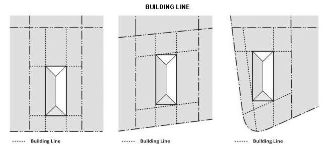
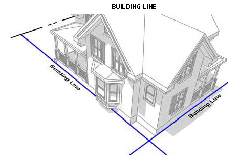
Building line. A line measured at the building wall of a structure between parallel lot lines. For the purposes of establishing a building line, the building wall does not include permitted encroachments of architectural features, such as bay windows, eaves, and steps and stoops.
Building permit. A certificate issued by the chief codes enforcement officer authorizing, with respect to this code, the erection, demolition, relocation, enlargement, or alteration of a structure, or uses thereof, in conformity with provisions of this code, the building code, and any other applicable code of the city.
Bulk. A term used to describe the size, volume, area, and shape of buildings and structures, and the physical relationship of their exterior walls or their location to lot lines, other buildings and structures, or other walls of the same building, and all open spaces required in connection with a building, other structure, or tract of land.
Business. An occupation, employment, or enterprise that occupies time, attention, labor and materials, where merchandise is exhibited or sold, or where services are offered.
Canopy. A canopy is a roof-like cover designed for protection from the weather or as a decorative embellishment, which projects from a wall or roof of a structure or may be freestanding, with supports that extend to the ground. A canopy may be one of two types:
1.
Canopy—Non-structural. A roofed structure attached to a building, which is not integral to the structure, that is made of durable, weather-resistant material such as canvas, canvas-like material, nylon, or vinyl-coated fabric, placed to extend outward from the building and supported both by mountings on the structure wall and by supports that extend to the ground.
2.
Canopy—Structural. A roofed structure constructed of permanent building materials, such as metal, brick, or similar materials, that is constructed as part of and attached to a building, and extends outward from the building and supported both by the structure and by supports that extend to the ground. Certain structural canopies may also be constructed as a freestanding structure on the same lot with the principal use and/or structure.
Certificate of occupancy. A certificate issued by the chief codes enforcement officer upon completion of construction, alteration, or change in occupancy or use of a building. The certificate acknowledges compliance with all the requirements of this code and any other applicable code of the city, and any adjustments granted by the zoning board of appeals.
Chicken coop. A structure where hens are kept.
Chief codes enforcement officer. The administrative officer charged with the enforcing of the provisions of this code. Also cited as "codes enforcement officer."
Chimney. A vertical shaft of reinforced concrete, masonry or other approved material enclosing one or more flues, for the purpose of removing products of combustion from solid, liquid, or gaseous fuel.
Co-location. Placement of wireless telecommunications equipment from more than one service or service provider on a single tower or site.
Commercial vehicle. Any vehicle with a gross vehicular weight greater than 10,000 pounds and/or having a one-and-one-half ton weight load bed capacity or more. Additionally, the term commercial vehicle includes, but is not limited to, any truck, van, panel truck, delivery van, trailer, semi-trailer, or pole trailer drawn by a motor vehicle, whether or not the vehicle meets or exceeds the limits set forth above, which is designed, used, and/or maintained for any of the following purposes: the transportation of more than ten persons; the delivery of property for hire, compensation, or profit; or transportation or hauling of personal property or equipment in the furtherance of a commercial enterprise. Construction equipment or other similar motorized machinery or vehicles not designed and intended for passenger use or for on-the-road hauling are deemed commercial vehicles.
Comprehensive plan. Plans and policy statements prepared by and for the city in accordance with the general city law identifying land use areas and objectives and public facilities and other community features, and providing for the improvement of the city and for its future growth, protection, and development. The comprehensive plan may be amended from time to time to reflect changing community conditions and needs.
Contiguous. See abut.
Crawl space. An enclosed area beneath the lowest elevated floor, 18 inches or more in height, which is used to service the underside of the lowest elevated floor. The elevation of the floor of this enclosed area, which may be of soil, gravel, concrete, or other material, must be equal to or above the lowest adjacent exterior grade. The enclosed crawl space area must be properly vented to allow for the equalization of hydrostatic forces which would be experienced during periods of flooding.
Cross-access. A vehicular and/or pedestrian connection between abutting properties that connects the two sites and allows vehicles and/or pedestrians to travel between sites without the having to exist to the street.
Cutoff. The point at which all light rays emitted by a lamp, light source or luminaire are generally eliminated (cutoff) at a specific angle above the ground, acknowledging that some light trespass may occur.
dBA. A sound level in decibels determined using the A-weighting network of a sound level meter.
Day. A calendar day.
Decibel (dB). A unit of measure, on a logarithmic scale, of the ration or magnitude of a particular sound pressure to a standard reference pressure, which, for purposes of this code, is 20 micropascals.
Deck. A roofless outdoor space built as an aboveground platform projecting from the wall of a structure and connected by structural supports at grade or by the structure.
Development. The construction, reconstruction, conversion, structural alteration, relocation, or enlargement of any structure, any mining, excavation, landfill or land disturbance, or any change in use, or alteration or extension of the use, of land.
Donation box. A container used for the purpose of collecting donated items for resale or for use by a charitable organization or institution.
Driveway. A pathway for motor vehicles from a street to a lot used only for service purposes or for access to the lot.
Dwelling. A building designed or used for residential occupancy as the living quarters for one or more households.
Dwelling unit. A building, or portion thereof, that contains complete housekeeping facilities for one family.
Easement. Land designed by lawful agreement between the owner(s) of the land and a person(s) for a specified use only by such person(s).
Eave. The projecting lower edges of a roof overhanging the wall of a structure.
Elevated building. A non-basement building:
(a)
Built, in the case of a building in zones A1-A30, AE, A, A99, AO, AH, B, C, X, or D, to have the top of the elevated floor, or in the case of a building in zones V1-30, VE, or V, to have the bottom of the lowest horizontal structure member of the elevated floor, elevated above the ground level by means of pilings, columns (posts and piers), or shear walls parallel to the flow of the water.
(b)
Adequately anchored so as not to impair the structural integrity of the building during a flood of up to the magnitude of the base flood.
In the case of zones A1-A30, AE, A, A99, AO, AH, B, C, X, or D, elevated building also includes a building elevated by means of fill or solid foundation perimeter walls with openings sufficient to facilitate the unimpeded movement of floodwaters. In the case of zones V1-V30, VE, or V, elevated building also includes a building otherwise meeting the definition of elevated building, even though the lower area is enclosed by means of breakaway walls that meet the federal standards.
Emergency. A public calamity, utility services failure, or an exposure of any person or property to actual or immediate danger.
Emergency operations. The work or activity that is needed to prevent or recover from an emergency including, but not limited to, fire or burglar alarms and other emergency signaling devices and work to repair electric, gas, water, sewer, or telephone services.
Encroachment. The extension or placement of any structure, or a component of such, into a required setback or right-of-way.
Erect. To build, construct, attach, hang, place, suspend, or affix.
Evergreen tree or hedge. Evergreen is a plant that maintains its leaves year-round.
Exterior lighting. The illumination of an outside area or object by any man-made device that produces light by any means.
Exterior stairwell. One or more flights of stairs, and the necessary landings and platforms connecting them, to form a continuous passage from the entryway of a floor or level to another in a structure located on the exterior of a principal building.
Family. Family, also cited as household in this code, is defined as:
(a)
One or more persons, whether or not related to each other by blood, marriage, adoption, or foster relationships, all living together as a single housekeeping unit, so long as such persons together occupy and own, lease, or rent the whole of a dwelling unit and use all rooms and living areas in common.
(b)
Any such number of persons are not deemed to constitute a family if:
i.
Any one of such persons does not have lawful access to all rooms or living areas of the dwelling unit.
ii.
Any one or more of such persons lease or rent any separate rooms or living areas of such dwelling unit from any other person.
(c)
It is presumed that a dwelling unit is occupied by more than one family if any two or more of the following features are found to exist by the codes enforcement officer:
i.
More than one gas meter.
ii.
More than one mailbox, mail slot or post office address.
iii.
More than one doorbell or doorway on the same side of the dwelling unit.
iv.
More than one electric meter.
v.
More than one connecting line for cable television.
vi.
Separate entrances for segregated portion of the separate rooms or living areas of the dwelling unit.
vii.
Locked internal doors barring access between segregated rooms or living areas of the dwelling unit, including bedrooms.
viii.
Separate written or oral leases or rental agreements for separate rooms or living areas of the dwelling unit among its owners and residents.
ix.
Two or more kitchens, each of which contain a range or oven, refrigerator and sink.
(d)
The presumption provided for in this paragraph is a rebuttable. Such presumption may be rebutted by proof that the dwelling unit is occupied by one family, including proof of the condition of the premises and/or proof of relationship or living arrangements of the residents.
(e)
The codes enforcement officer will make the primary determination as to the application of this definition of family for the purposes of compliance with any provisions of this code and the state building code, based upon his/her inspection of the premises, any information he/she may receive from the residents thereof or any other person, or any written evidence as to the condition of the premises and/or the relationship and living arrangements of the residents. His/her determination is be presumed to be correct and final, subject to review of or appeal to the zoning board of appeals and judicial review as provided by law.
Federal Emergency Management Agency. The federal agency that administers the National Flood Insurance Program.
Fence. A structure used as a boundary, screen, separation, means of privacy, protection or confinement, and is constructed of wood, plastic, metal, wire mesh, masonry, or other similar material and is used as a barrier.
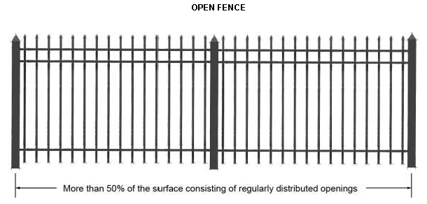
Fence, open. A fence that has, over its entirety, more than 50 percent of the superficial surface consisting of regularly distributed openings.
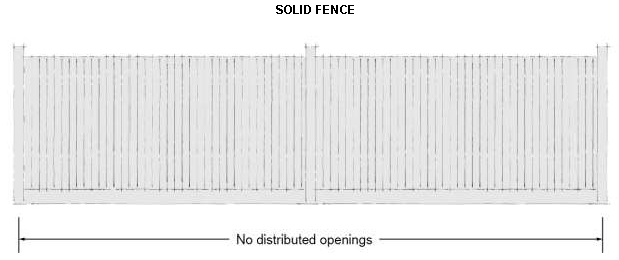
Fence, solid. A fence that has, over its entirety, no distributed openings. A shadowbox design fence is considered a solid fence. A chain link fence with slats is not considered a solid fence.
Fixture. The assembly that houses the lamp or lamps, which may include all or some of the following parts: a housing, a mounting bracket or pole socket, a lamp holder, a ballast, a reflector or mirror, and/or a refractor or lens.
Flood or flooding. A general and temporary condition of partial or complete inundation of normally dry land areas from:
(a)
The overflow of inland or tidal waters.
(b)
The unusual and rapid accumulation or runoff of surface waters from any source.
Flood or flooding also means the collapse or subsidence of land along the shore of a lake or other body of water as a result of erosion or undermining caused by waves or currents of water exceeding anticipated cyclical levels or suddenly caused by an unusually high water level in a natural body of water, accompanied by a severe storm, or by an unanticipated force of nature, such as a flash flood or an abnormal tidal surge, or by some similarly unusual and unforeseeable event which results in flooding as defined above.
Flood boundary and floodway map (FBFM). An official map of the community published by the Federal Emergency Management Agency as part of a riverine community's flood insurance study. The FBFM delineates a regulatory floodway along water courses studied in detail in the flood insurance study.
Flood elevation study. An examination, evaluation, and determination of the flood hazards and, if appropriate, corresponding water surface elevations, or an examination, evaluation, and determination of flood-related erosion hazards.
Flood hazard boundary map (FHBM). An official map of a community, issued by the Federal Emergency Management Agency, where the boundaries of the areas of special flood hazard have been designated as zone A but no flood elevations are provided.
Flood insurance rate map (FIRM). An official map of a community, on which the Federal Emergency Management Agency has delineated both the areas of special flood hazard and the risk premium zones applicable to the community.
Floodlight. An attention-getting device where an artificial light of high intensity is shined upward in a focused beam to attract attention to a location. A floodlight is not focused on a sign or sign face.
Floodplain or flood-prone area. Any land area susceptible to being inundated by water from any source (see definition of flooding).
Floodproofing. Any combination of structural and non-structural additions, changes, or adjustments to structures which reduce or eliminate flood damage to real estate or improved real property, water and sanitary facilities, structures and their contents.
Floodway, regulatory. The channel of a river or other watercourse and the adjacent land areas that must be reserved in order to discharge the base flood without cumulatively increasing the water surface elevation more than a designated height as determined by the Federal Emergency Management Agency in a flood insurance study or by other agencies as provided in this code.
Functionally dependent use. A use which cannot perform its intended purpose unless it is located or carried out in close proximity to water, such as a docking or port facility necessary for the loading and unloading of cargo or passengers, shipbuilding, and ship repair facilities. The term does not include long-term storage, manufacturing, sales, or service facilities.
Garage. A structure, either attached or detached, used for the parking and storage of vehicles as an accessory use to a residence. Garage does not include a parking structure.
Gazebo. A freestanding outdoor structure designed for recreational use and not for habitation.
Glare. Light emitting from a luminaire with an intensity great enough to reduce a viewers' ability to see, cause discomfort, and, in extreme cases, cause momentary blindness.
Grade. Defined in section 80-3.3.
Green roof. A building roof partially or completely covered with vegetation and a growing medium, planted over a waterproofing membrane. It may also include additional layers such as a root barrier and drainage and irrigation systems.
Greenhouse (accessory). A structure constructed chiefly of glass, glasslike or translucent material, cloth, or lath, which is devoted to the protection or cultivation of flowers or other tender plants.
Gross floor area (GFA). Defined in section 80-3.3.
Hazardous substance. Any substance, material, or waste appearing on either of:
(a)
The Title III List of Lists: Chemicals Subject to Reporting Under Title III of the Superfund Amendments and Reauthorization Act (SARA) of 1986 published July, 1987, U.S. Environmental Protection Agency.
(b)
Hazardous Materials Table, in the Code of Federal Regulations (CFR), title 49, part 173.101.
Hedge. A row of closely planted shrubs, bushes, or any kind of plant forming a boundary.
Historic structure. Any structure that is:
(a)
Listed individually in the National Register of Historic Places (a listing maintained by the Department of the Interior) or preliminarily determined by the Secretary of the Interior as meeting the requirements for individual listing on the National Register.
(b)
Certified or preliminarily determined by the Secretary of the Interior as contributing to the historical significance of a registered historic district or a district preliminarily determined by the Secretary to qualify as a registered historic district.
(c)
Individually listed on a state inventory of historic places in states with historic preservation programs which have been approved by the Secretary of the Interior.
(d)
Individually listed on a local inventory of historic places in communities with historic preservation programs that have been certified either:
(i)
By an approved state program as determined by the Secretary of the Interior.
(ii)
Directly by the Secretary of the Interior in states without approved programs.
Home occupation. Any activity customarily carried out for gain by a resident, conducted as an accessory use in the resident's dwelling unit.
Illumination system. The totality of the equipment installed to provide exterior lighting on a developed property. Illumination system includes all structures, canopy, pole, and ground-mounted luminaires, including all wiring, circuitry, and other devices installed to create exterior lighting.
Impervious surface coverage. Defined in section 80-3.3.
Impulsive sound. A single noise event or series of single noise events, which result in a high peak sound level of short duration (less than one second). Examples include, but are not limited to, gunshots, blasting, or hammering.
In-season storage. For purposes of this code, permitting any registered or nonregistered recreational vehicle, recreational craft, recreational vessel, trailer, or similar piece of equipment to be parked, placed or set on a property during any part of the calendar year that such vehicle, craft, vessel, trailer, or similar equipment is typically used.
Infrastructure. Facilities and services needed to sustain residential, commercial, industrial, institutional, and other activities.
Internal illumination (sign). Illumination from a light source that is contained within a sign.
Intensity of use. Square feet of gross floor area, number of dwelling units, number of employees, or other factor used as a basis for requiring off-street parking or loading facilities.
Lamp. The component of a luminaire that produces the actual light.
Lamp wattage. The amount of power of a lamp expressed in watts.
Lighting. Defined in section 80-3.3.
Light, direct. Light emitted directly from the lamp, off a reflector or reflector diffuser, or through the refractor or diffuser lens of a luminaire.
Light, indirect. Direct light that has been reflected or has scattered off of other surfaces.
Light pole banner. Banners mounted on and with arms installed perpendicular to light poles.
Light trespass. The shining of light produced by a luminaire beyond the boundaries of the property on which it is located.
Livestock enclosure. An outdoor pen constructed to confine livestock.
Loading space. A space within a loading facility exclusive of driveways, aisles, maneuvering areas, ramps, columns, landscape, and structures for the temporary parking of a commercial delivery vehicle while loading or unloading goods or materials.
Lot. Defined in section 80-3.3.
Lot area. Defined in section 80-3.3.
Lot coverage. Defined in section 80-3.3.
Lot, corner. Defined in section 80-3.3.
Lot depth. Defined in section 80-3.3.
Lot, interior. Defined in section 80-3.3.
Lot line. Defined in section 80-3.3.
Lot line, corner. Defined in section 80-3.3.
Lot line, front. Defined in section 80-3.3.
Lot line, interior. Defined in section 80-3.3.
Lot line, rear. Defined in section 80-3.3.
Lot line, street. Defined in section 80-3.3.
Lot of record. An area designated as a separate and distinct parcel of land on a properly filed subdivision plat or in a legally recorded deed as filed in the official records of the office of the county clerk.
Lot, through. Defined in section 80-3.3.
Lot width. Defined in section 80-3.3.
Lowest floor. The lowest level of a building or structure, including a basement, cellar, crawl space, or garage of lowest enclosed area. In the flood damage protection district, an unfinished or flood-resistant enclosure, usable solely for parking of vehicles, building access, or storage in an area other than a basement area is not considered a building's lowest floor, provided that such enclosure is not built so as to render the structure in violation of the applicable non-elevation design requirements of this code.
Luminaire. A complete lighting unit consisting of a light source and all necessary mechanical, electrical, and decorative parts.
Luminaire, cut-off type. A luminaire containing elements such as shields, reflectors, or refractor panels that direct and cut off a direct view of the light source at a cut off angle.
Marquee. A permanent roof-like structure constructed of durable material extending from the wall of a structure with no supports extending to the ground with a portion of the structure dedicated to sign area that may be changed.
Mean sea level. For purposes of the National Flood Insurance Program, the National Geodetic Vertical Datum (NGVD) of 1929, the North American Vertical Datum of 1988 (NAVD 88), or other datum, to which base flood elevations shown on a community's flood insurance rate map are referenced.
Menuboard. A sign constructed as part of drive-through facilities.
Modular home. Modular buildings and modular homes are not considered manufactured homes, and refer to a method of construction. Modular buildings and modular homes are built in multiple sections called modules at a facility and then delivered to the site where the modules are set onto the building's foundation and joined together to make a single building. Modular buildings and modular homes must conform to all zoning requirements for the dwelling type and must meet all building code requirements.
Multi-tenant retail center. A group of two or more commercial establishments that is planned, owned, and/or managed as a single property. The two main configurations of multi-tenant retail centers are large shopping centers/malls and strip centers.
Nonconforming lot. A lot of record that at one time conformed to the lot dimension requirements (lot area, lot width, lot depth) of the zoning district in which it is located but because of subsequent amendments to the code no longer conforms to the applicable lot dimensions.
Nonconforming sign. A sign that once conformed to zoning district regulations but because of subsequent amendments to the code no longer conforms to applicable sign regulations.
Nonconforming site element. A site development element, such as landscape, fences or walls, lighting, and parking, that at one time conformed to the requirements of this code, but because of subsequent amendments, has been made nonconforming.
Nonconforming structure. A principal or accessory structure that once conformed to zoning district regulations but because of subsequent amendments to the code no longer conforms to applicable dimensional standards.
Nonconforming use. The use of a structure or land that at one time was an allowed use within a zoning district but because of subsequent amendments to the code is no longer allowed.
Non-residential use. A structure or land arranged, designed, used, or intended to be used for non-residential uses, which includes, but is not limited to, retail, office, entertainment, recreation, public, institutional, and other non-residential uses. Structures with dwellings above ground floor non-residential uses are considered mixed-use development and considered a non-residential use for the purposes of this code.
Off-season storage. For purposes of this code, permitting any registered or nonregistered recreational vehicle, recreational craft, recreational vessel, trailer, or similar piece of equipment to be parked, placed or set on a property during any part of the calendar year, during that time of the year that such vehicle, craft, vessel, trailer, or similar equipment is typically not used.
Off-street parking. The storage space for an automobile on premises other than streets or rights-of-way.
Open space. That portion of land, either landscaped or left unimproved, which is used to meet active or passive recreation or spatial needs, and/or to protect water, air, or plant resources.
Outdoor display and sales area. Part of a lot used for outdoor sales and/or display of goods accessory to the principal use.
Outlot. An area of land set aside within a retail center for a separate principal building that shares a circulation system and may share common parking with the larger retail center development but is separated from the principal building or buildings, typically located along the property line.
Overlay district. A district established in the code that is superimposed on one or more zoning districts or parts of zoning districts. The standards and requirements associated with an overlay district may be more or less restrictive than those in the underlying districts.
Owner. Any person, including the owner of the title or a mortgage whose interest is shown of record in the mortgage and conveyance records of the county; a person shown as owner in the records of the tax assessor of the county in which the property is situated; or the agent of any such person and those in possession of a dwelling, dwelling unit, or lot(s).
Parapet. The extension of a false front or wall above a roof-line.
Party wall. A wall starting from the foundation and extending continuously through all stories to or above the roof that separates one building from another, but is in joint use by each building.
Patio. A hard surface designed and intended for recreational use by people and not used as a parking space.
Performance standards. A set of criteria or limits relating to elements that a particular use or process must either meet or may not exceed.
Pergola. A freestanding, open structure that forms a partially shaded pedestrian walkway, passageway, or sitting area, and is constructed of a semi-open roof and vertical posts that support cross-beams and a sturdy open lattice. It may also be used as an extension of a building entryway.
Pervious paving. A range of sustainable materials and techniques for permeable paving with a base and sub-base that allow the movement of stormwater through the surface. Gravel and loose rock are not considered pervious paving.
Plat. A map or chart indicating the subdivision or resubdivision of land.
Porch. An architectural feature that projects from the exterior wall of a structure, has direct access to the street level of the building, and is covered by a roof or eaves.
Porch—Enclosed. A porch enclosed by walls, screens, lattice or other material. A screened-in porch is an enclosed porch.
Porch—Unenclosed. A porch that is open on all sides that do not abut a principal building wall.
Property line. See lot line in section 80-3.3.
Primary thoroughfare. The following highways and/or streets and their appurtenant rights-of-way, are deemed primary thoroughfares for purposes of this Code: Black River Boulevard; Erie Boulevard; James Street; Dominick Street; and Liberty Street.
Principal building. A building in which the main or principal use of the lot on which said building is situated is conducted.
Principally above ground. At least 51 percent of the actual cash value of the structure, excluding land value, is above ground.
Principal use. The main use of land or structures as distinguished from an accessory use.
Private road. A right-of-way, other than a street, which provides vehicular access to two or more lots.
RMS velocity. Root mean square amplitude velocity, which is used to describe the smoothed vibration amplitude evolution.
Railroad right-of-way. A strip of land with tracks and auxiliary facilities for track operation, but not including depots, loading platforms, stations, train sheds, warehouses, car shops, car yards, locomotive shops, or water towers.
Residential use. A structure arranged, designed, used, or intended to be used for residential occupancy by one or more families or households, which includes, but is not limited to, the following types: Single-family-detached and attached, two-family, townhouse, and multi-family dwellings. Structures with dwellings above ground floor non-residential uses are considered mixed-use development, which are considered a non-residential use for the purposes of this code.
Recreational craft. A vehicle with or without motive power, which is primarily designed for sport or recreational use, which includes, but is not limited to, snowmobiles, boats, all-terrain vehicles (ATVs), jet skis, etc. The term recreational craft does not include the term recreational vehicle.
Recreational vehicle. A vehicle with or without motive power, which is designed for recreational use and human occupancy and which meets the following qualifications:
(a)
Is not used as the permanent residence of the owner or occupant.
(b)
Is used for temporary living quarters by the owner or occupant while engaged in recreation, travel, or vacation activities.
(c)
Is towed or self-propelled on public streets or highways incidental to such recreation or vacation activities.
Examples of such vehicles include, but are not limited to, motor homes, fifth-wheel trailers, van campers, tent camping trailers, self-contained travel trailers, pick-up truck campers, camping buses, and self-contained self-propelled truck chassis mounted vehicles providing living accommodations.
Residential subdivision. A residential neighborhood developed as an integrated whole and typically with a specific identity.
Right-of-way. A strip of land dedicated for use as a public way. In addition to the roadway, it typically incorporates the curbs, parkways, sidewalks, and shoulders.
Roofline. The top edge of a roof or building parapet, whichever is higher, excluding any cupolas, pylons, chimneys or minor projections.
Satellite dish antenna. A dish antenna designed for transmitting signals to a receiver or receiving station or for receiving television, radio, data, communication or other signals from other antennas, satellites or other services.
Secondary thoroughfare. Any highway and/or street not included within the definition of primary thoroughfare, as said term is defined in this code.
Setback. Defined in section 80-3.3.
Setback, front. Defined in section 80-3.3.
Setback, interior side. Defined in section 80-3.3.
Setback, corner side. Defined in section 80-3.3.
Setback, rear. Defined in section 80-3.3.
Shade tree. A tree grown specifically for its shade, which usually applies to large trees with spreading canopies.
Shed. An accessory structure, often purchased pre-built or as a kit in pre-fabricated sections, that is not designed to be served by heat or plumbing and does not need to be placed on a permanent foundation. A shed is typically intended to store lawn, garden, or recreational equipment.
Sign. Any identification, description, illustration, or device illuminated or non-illuminated that is visible to the public from adjoining streets or adjoining properties and that directs attention to a product, service, place, activity, person, institution, business, or solicitation, including any permanently installed or situated merchandise; or any emblem, painting, banner, pennant, placard, temporary sign, lights, balloons or other device designed to attract attention, advertise, identify or convey information. Building details that are an integral part of the overall architectural design of a building or works of art accessory to a building are not be considered signs.
Sign, A-frame. A temporary sign ordinarily in the shape of the letter "A" or some variation thereof, which is displayed on the ground, not permanently attached, and usually two-sided.
Sign, animated. Any sign that uses movement or change of lighting to depict action or create a special effect or scene. Animated signs include video screens, television screens, plasma screens, and holographic displays, but do not include electronic message center signs.
Sign area. Defined in section 80-3.3.
Sign, awning. A sign printed, mounted, or installed upon an awning.
Sign, canopy. A sign printed, mounted, or installed upon a canopy.
Sign, electronic message. A sign or component of a sign that uses LED illumination systems or other similar electronic components to form a message(s) that are electronically programmed or modified by electronic processes.
Sign, flashing. Any illuminated sign that contains an intermittent or flashing light source or that changes light intensity in sudden transitory bursts, but do not include electronic message center signs.
Sign, freestanding. Any sign on a frame, pole, or other support structure that is not attached to any building.
Sign, ghost. A painted wall sign that remains from an earlier time or advertises the use of a building that provides evidence of the history of the use of the building or activities of the community.
Sign height. Defined in section 80-3.3.
Sign, moving. Any sign that revolves, rotates, swings, undulates, or otherwise attracts attention by moving parts, whether operated by mechanical equipment or by natural sources, not including flags or banners.
Sign, projecting. Any sign that is attached to a building or other structure and extends beyond the line of the building or structure or beyond the surface of that portion of the building or structure to which it is attached by more than 12 inches.
Sign, roof. Any sign erected, constructed, and maintained above the parapet on a building with a flat roof or above the fascia board on a building with a pitched roof.
Sign, snipe. A sign painted, pasted or otherwise affixed to any tree, rock, retaining wall, fence, utility pole, hydrant, bridge, sidewalk, curb or street, bench, or trash receptacle. Logos and labels located on mechanical equipment, recycling bins, trash containers or dumpsters, which are part of the equipment as manufactured and/or installed, are not snipe signs.
Sign structure. Any structure that supports a sign, including any decorative cover.
Sign, temporary. Any sign intended to be displayed for a limited period of time and not to be permanently affixed.
Sign, wall. A single-faced sign attached generally flush or parallel to the wall of a building that projects less than 12 inches.
Sign, window. A sign that is attached to, placed upon, or printed on the interior or exterior of a window or door of a building, or displayed within two feet of a window intended for viewing from the exterior of such a building. A window sign may be either permanent or temporary. Shadowbox design within display windows, where the window display is designed with a background enclosure against which signs are mounted that blocks view into the establishment, is considered a window sign and subject to the maximum sign area limitation.
Sound. An oscillation in pressure in air.
Sound level. In decibels, a weighted sound pressure level, determined by the use of metering characteristics and frequency weightings specified in ANSI S1.4-1983.
Sound level meter. An instrument designed to detect and measure sound pressure levels and display this information in decibels, in an analog or digital form. An instrument meeting the requirements of this code must conform to the requirements of ANSI S1.4-1983, type 1 or type 3.
Stacking space. A space specifically designed and designated as a waiting area for vehicles patronizing a drive-through facility or service bay.
Start of construction. The date of permit issuance for new construction and substantial improvements to existing structures, provided that actual start of construction, repair, reconstruction, rehabilitation, addition placement, or other improvement is within 180 days after the date of issuance. The actual start of construction means the first placement of permanent construction of a building, including a manufactured home, on a site, such as the pouring of a slab or footings, installation of pilings or construction of columns. Permanent construction does not include land preparation, such as clearing, excavation, grading, or filling, or the installation of streets or walkways, or excavation for a basement, footings, piers or foundations, or the erection of temporary forms, or the installation of accessory buildings such as garages or sheds not occupied as dwelling units or not part of the main building. For a substantial improvement, the actual start of construction means the first alteration of any wall, ceiling, floor, or other structural part of a building, whether or not that alteration affects the external dimensions of the building.
Stoop. An exterior floor typically, constructed of stone, concrete, and/or masonry, with a finished floor elevation higher than the adjacent ground level, often with steps leading up to it, and utilized primarily as an access platform to a structure. A stoop may be roofed and designed with railings, but cannot be enclosed.
Street. A public road or private way open to general public use that affords principal means of access to abutting properties and is suitably improved, or a proposed way shown on a plan approved by the common council and/or on a map filed in the office of the county clerk.
Structure. Anything constructed or erected above ground, the use of which requires location on the ground or attachment to something having location on the ground, is of a permanent nature and is intended for human use and/or occupancy. The term structure does not include patios, driveways, sidewalks, terraces, and similar features.
Substantial damage. Damage of any origin sustained by a structure whereby the cost of restoring the structure to its before damaged condition would equal or exceed 50 percent of the market value of the structure before the damage occurred.
Substantial improvement. Any repair, reconstruction, or improvement of a structure that expands the total square footage of said structure by 25 percent or more either:
(a)
Before the improvement or repair is started.
(b)
If the structure has been damaged and is being restored, before the damage occurred. For purpose of this definition, substantial improvement is considered to occur when the first alteration of any wall, ceiling, floor or other structural part of the building commences, whether or not that alteration affects the external dimension of the structure.
The term does not, however, include either:
(a)
Any project for improvement of a structure to comply with existing state or local health, sanitary, or safety code specifications which are solely necessary to assure safe living conditions.
(b)
Any alteration of a structure listed on the National Register of Historic Places or a state or local inventory of historic places.
Swimming pool. Any body of water or receptacle for water having a depth at any point greater than two feet, used or intended to be used for swimming, and constructed, installed, or maintained in or above the ground. An in-ground swimming pool is deemed a structure for all purposes under the provisions of this code.
Tree lawn. That part of the pedestrian way that if designated for street trees, landscape, transit stops, street lights, outdoor dining, site furnishings, and the like, as well as for motorists to access cars parked at the curb. Parkway may also be referred to as neutral ground.
Unified control. The combination of two or more tracts of land wherein each owner has agreed that his tract of land will be developed under the same development approvals.
Use. The purpose or activity for which the land or structure is designed, arranged, or intended, or for which it is occupied or maintained.
Use variance. Permission for the use of land or buildings for a use that is not otherwise permitted by the zoning regulations.
Variance. A modification of the regulation of this code, granted on grounds as set forth in applicable regulations of this code and the applicable section of General City Law.
Wall. A constructed solid barrier of concrete, stone, brick, tile, or similar type of material that closes, marks, or borders a field, yard, or lot, and that limits visibility and restricts the flow of air and light.
Water feature. An artificially enclosed body of water or receptacle for water having a depth of less than three feet that may be used or intended to be used as an ornamental feature constructed, installed, or maintained in or above the ground. It may include a fountain display, water plants, or fish. A water feature is deemed a structure for all purposes under the provisions of this code.
White roof. A roof designed to deliver high solar reflectance, reducing heat transfer to the building and the ability to radiate absorbed, or non-reflected solar energy.
Yard. Defined in section 80-3.3.
Yard, front. Defined in section 80-3.3.
Yard, interior side. Defined in section 80-3.3.
Yard, corner side. Defined in section 80-3.3.
Yard, rear. Defined in section 80-3.3.
Zoning lot. A lot or combination of lots within a single block, which is designated by its owner or developer to be used, developed, or built upon as a unit. A zoning lot may or may not coincide with a lot of record.
Zoning map. The map or maps that are a part of this code and which delineate the boundaries of all mapped zoning districts within the physical boundary of the planning area.
(Ord. No. 9301A, 9-26-18)
Sec. 80-3.3. - Rules of measurement.
This section provides the rules of measurement for the dimensional standards and locational characteristics within the code.
(a)
Block and blockface.
i.
A block is a tract of land bounded by streets, or a combination of streets and railroad rights-of-way, shorelines of waterways, or municipal boundary lines.
ii.
Blockface is measured as that portion of a block or tract of land facing the same side of a single street and lying between the closest intersecting streets.
(b)
Build-to dimensions.
i.
A build-to line (BTL) is a set building line on a lot, located parallel to the applicable lot line, where the structure must be located. The building facade must be located on the build-to line. Facade articulation, such as window or wall recesses and projections are not counted as the building façade line, which begins at the applicable façade wall.
ii.
A build-to zone (BTZ) is the area on a lot, located parallel to the applicable lot line, where a structure must locate within the minimum and maximum range of setback provided. The building facade must be located within the build-to zone. Facade articulation, such as window or wall recesses and projections are not counted as the building façade line, which begins at the applicable façade wall.
iii.
A build-to percentage specifies the percentage of the building facade that must be located within a build-to line or build-to zone, as a percentage of the lot width. Facade articulation, such as window or wall recesses and projections, do not count against the required build-to percentage.
(c)
Building height.
i.
Building height is measured as the vertical distance measured from the established grade at the curb or, if no grade has been officially established at the curb, measured from the average level of the finished ground surface across the front of the building to:
a.
The highest point of the roof for flat roofs or decorative mansard roofs.
b.
To the deck line of mansard roofs.
c.
To the mean height between eaves and ridge for gable, hip, and gambrel roofs.
ii.
The following structures or parts thereof are exempt from maximum height limitations, unless otherwise limited by any height restriction imposed by any airport authority, or other similar federal, state, or local authority.
a.
Public utility poles, towers, and wires. This does not include wireless telecommunication towers and wind turbines that are regulated separately by this code.
b.
Water tanks and standpipes.
c.
Building appurtenances such as chimneys, parapet walls, skylights, steeples, flag poles, smokestacks, cooling towers, elevator bulkheads, fire towers, monuments, water towers, stacks, stage towers, or scenery lofts, tanks, ornamental towers and spires, rooftop accessory structures, recreational facilities, or necessary mechanical appurtenances.
iii.
A story is measured as that portion of a building included between the surface of any floor and the surface of the floor next above it, or if there be no floor above it, then the space between any floor and the ceiling next above it.
iv.
A half-story is measured as that portion of a building between a pitched roof and the uppermost full story, said part having a ceiling height of seven feet or more for an area not exceeding one-half the floor area of said full story, and in which space not more than two-thirds of the floor area is finished off as rooms.
(d)
Grade.
i.
The elevation at which the finished surface of the surrounding lot intersects the walls or supports, or a building or other structure. If the line of the intersection is not reasonably horizontal, the finished grade in computing height of buildings and other structures or for other purposes will be the average elevation of all finished grade elevations around the periphery of the building, except that the finished grade cannot be higher than one-half of the floor to ceiling height.
ii.
Highest adjacent grade means the highest natural elevation of the ground surface, prior to construction, next to the proposed walls of a structure.
(e)
Gross floor area (GFA). The sum of the gross horizontal areas of the several floors of a building, including interior balconies, mezzanines, and basements, but excluding exterior balconies and attics. All horizontal dimensions of each floor area are measured to the exterior face of walls of each such floor, including the walls of roofed porches having more than one wall.
i.
More specifically in computing the gross floor area, the following is included:
a.
Any floor area devoted to mechanical equipment serving building with structural headroom of seven feet, six inches or more.
b.
Elevator shafts and stairwells at each floor.
c.
Penthouses.
d.
Interior balconies and mezzanines.
e.
Enclosed porches.
f.
Basements and cellar space.
ii.
The following is not included:
a.
Accessory off-street parking or unloading spaces.
b.
Uncovered steps, exterior fire escapes.
c.
Terraces, stairways, open porches, and outside balconies.
d.
Accessory outside water tanks and cooling towers or equipment.
(f)
Impervious surface coverage.
i.
Impervious surface coverage is a measure of intensity of land use that represents the portion of a site that is occupied by structures, pavement, and other impervious surfaces that do not allow for the absorption of water into the ground. Maximum impervious surface of a lot is calculated as the percentage of all impervious surface area against the total area of the lot.
ii.
When pervious paving is used, it is calculated at a reduced percentage of impervious coverage, as follows unless another calculation is decided upon by the codes enforcement officer:
a.
Pervious concrete and open grid paving systems are calculated as 50 percent impervious surface, provided that no barrier to infiltration is installed beneath the material. Open grid pavers must be installed on a sand base, without an impervious liner, to qualify.
b.
Other types of pervious surfaces, such as permeable pavers, porous asphalt, or gravel-crete, are credited based upon field performance data and coefficients of permeability provided by the manufacturer.
(g)
Lighting.
i.
Luminaire height. The total height of a luminaire is measured to the top of the pole or luminaire, whichever is higher, from grade.
ii.
Footcandle. A footcandle (FC) is a unit of illumination produced on a surface, all points of which are one foot from a uniform point source of one standard candle. Footcandle is measured utilizing a direct reading, portable light meter mounted in a horizontal position.
(h)
Lot. A parcel of land considered as a unit, occupied or capable of being occupied by a principal building and accessory buildings or uses, or by a group of buildings united by a common use or interest, and any open space as are required by this code. The following describes the types of lot configurations:
i.
An interior lot is a lot other than a corner or through lot, bounded by two interior side lot lines.
ii.
A corner lot is a lot situated at the junction of, and abutting on, two or more intersecting streets.
iii.
A through lot is a lot which fronts upon two parallel streets, or which fronts upon two streets which do not intersect at the boundaries of the lot.
iv.
A flag lot has two distinct parts:
a.
The flag, which is the only building site and is generally located behind another lot.
b.
The pole, which connects the flag to the street, and provides the only street frontage for the lot and at any point is less than the minimum lot width for the zone.
(i)
Lot area. The total area within the boundaries of a lot, excluding any street right-of-way, usually defined in square feet or acres. No part of the area within a public right-of-way is included in the computation of lot area
(j)
Lot coverage. That portion of the lot that is or may be covered by principal buildings and accessory structures.
(k)
Lot depth. The distance measured from the front lot line to the rear lot line. For lots where the front and rear lot lines are not parallel, the lot depth is the depth calculated at the deepest part of the lot.
(l)
Lot line. A line of record bounding a lot, as indicated on an approved, filed, and recorded subdivision plat, which divides one lot from another lot or from a public or private street or any other public or private space and includes:
i.
A front lot line is the lot line separating a lot from a street right-of-way. The front lot line of a corner lot is the shortest street lot line of a corner lot abutting a street. A front lot line for a through lot is both lot lines that abut a street.
ii.
A rear lot line is the lot line opposite and most distant from the front lot line, or in the case of triangular or otherwise irregularly shaped lots, an assumed line at least ten feet in length entirely within the lot, parallel to and at a maximum distance from the front lot line.
iii.
On a corner lot, the corner side lot line is perpendicular or approximately perpendicular to the front lot line and is the longer street abutting lot line of a corner lot.
iv.
On an interior lot, the interior side lot line is perpendicular or approximately perpendicular to the front lot line and abuts the adjacent lot.
v.
A street lot line is any lot line separating a lot from a street right-of-way.
(m)
Lot width.
i.
For regular lots, lot width is the horizontal distance between the side lot lines measured at right angles to its depth along a straight line parallel to the required front setback, build-to line, or farthest build-to line comprising a build-to zone.
ii.
For cul-de-sac lots, on those lots with a curved front lot line, lot width is measured as follows:
a.
A line is drawn at the midpoint of the lot between the side lot lines, extending from the front lot line to the rear lot line.
b.
Where the required front setback intersects the midpoint line at a right angle, a line is drawn perpendicular to the midpoint line.
c.
Lot width is determined as the length of the line between side lot lines.
d.
Where the side lot lines angle to increase width towards the rear, the required lot width measured at the required setback is 75 percent of the lot width required by the zoning district.
iii.
For flag lots, lot width is measured at the required front setback as defined in this section.
(n)
Sign dimension measurement.
i.
Calculation of sign area.
a.
For signs on a background, the entire area of the background is calculated as sign area, including any material or color forming the sign face and the background used to differentiate the sign from the structure against which it is mounted. Sign area does not include any supports or bracing.
b.
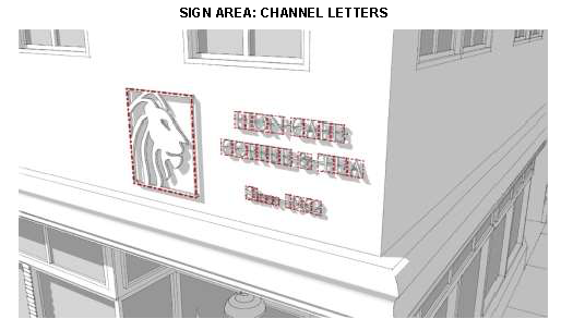
For signs consisting of channel letters or freestanding logos, the sign area is calculated as the total area of each square, circle, rectangle, or triangle, or combination thereof, that encompasses each individual letter or logo. Sign area does not include any supports or bracing.
c.
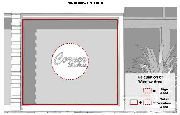
Window area for the purpose of calculating maximum window sign area is calculated as a continuous surface until divided by an architectural or structural element. Mullions are not considered an element that divides window area. Window signs printed on a transparent film and affixed to the interior or exterior of a windowpane or glass door are calculated as individual letters or logos, provided that the portion of the transparent film around the perimeter of the individual letters or logos maintains 100 percent transparency of the window.
ii.
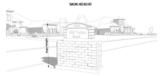
Measurement of sign height. For ground signs, sign height is measured as the vertical distance measured from the base of the sign to the highest point of the sign, including any decorative elements.
iii.
Measurement of vertical clearance. For building-mounted signs, vertical clearance is measured as the vertical distance measured from the ground directly below the sign to the lowest point of the sign.
![]()
iv.
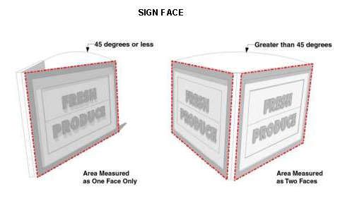
Determination of number of sign faces. If the interior angle between two sign faces is 45 degrees or less, the sign area is computed as the area of one face only. If the angle between two sign faces is greater than 45 degrees, the total sign area is computed as the sum of the areas of the two faces.
v.
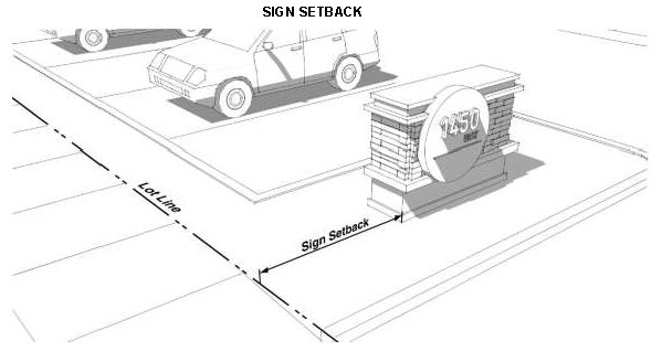
Sign setback. A required sign setback is measured from the applicable lot line to the closest point of the sign.
(o)
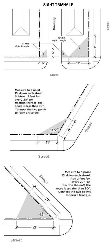
Sight triangle. A sight triangle is located at the intersection of the street or alley right-of-way, access easement, and/or driveway pavement, is measured at a line joining the points at a distance as follows:
i.
Five feet from the point of the intersection of driveways and the lot line, as measured along the lot line and edge of driveway pavement.
ii.
For intersections forming a 90 degree angle, 15 feet down each street measured along the right-of-way.
iii.
For intersections forming an angle greater than 90 degrees, 15 feet down each street measured along the right-of-way, minus two feet for each 20 degrees or fraction thereof the angle exceeds 90 degrees.
iv.
For intersections forming an angle less than 90 degrees, 15 feet down each street measured along the right-of-way, plus two feet for each 20 degrees or fraction thereof the angle is less than 90 degrees.
(p)
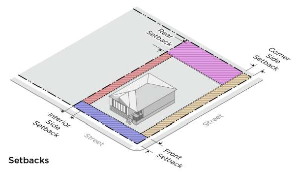
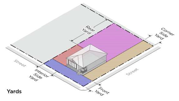
Yards and setbacks.
1.
General definitions.
a.
A yard is the open space area between the building line, of a principal building and the adjoining lot lines, exclusive of facade articulation, such as window or wall recesses and projections.
b.
A required setback is the required minimum distance a principal building must be located from a lot line, which is unoccupied and unobstructed by any projections of a principal building, unless permitted by this code.
i.
A build-to zone or build-to line is considered a required setback.
ii.
In the case of a build-to line it is where the principal building must be located.
iii.
In the case of a build-to zone, it is the defined area (defined by minimum and maximum build-to lines) where the principal building must be located.
c.
A setback may be equal to or lesser than a yard.
d.
A setback is located along the applicable lot line for the minimum depth specified by the zoning district in which such lot is located.
2.
Front yard and front setback. The front yard and front setback extend the full width of the lot between side lot lines measured perpendicular to the front lot line.
a.
Front yard. A front yard is located between a principal building line and the front lot line.
b.
Front setback. A front setback is the required minimum distance per the zoning district that a principal building must be located from the front lot line.
c.
A front setback is measured from the right-of-way line.
d.
Front setbacks on irregular lots are subject to the additional provisions:
i.
On a lot with a radial (curved) front lot line, the required front setback, as measured from the right-of-way line follows the curve of the lot line.
ii.
For flag lots, the front yard and setback is measured from the rear lot line of the lot that separates the flag portion of the lot from the street.
e.
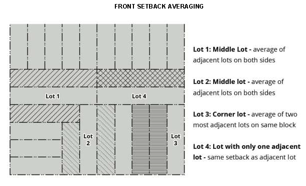
Front setback averaging. The average of the front setback of the adjacent lots on either side of a lot may be used to establish the required front setback. Averaging is based on the two adjacent lots or, in the case of a corner lot, two neighboring lots on the same blockface. In the case of a lot configuration where only one lot is available for averaging, the required front setback is that of the adjacent lot.
3.
Interior side yard and interior side setback. The interior side yard and interior side setback extend along the interior side lot line between the front and rear yard or setback, measured perpendicular to the interior side lot line.
a.
Interior side yard. An interior side yard is located between a principal building line and the interior side lot line.
b.
Interior side setback. An interior side setback is the required minimum distance per the zoning district that a principal building must be located from the interior side lot line.
c.
For townhouse developments, the interior side yard and interior side setback are applicable to end units only.
4.
Corner side yard and corner side setback. The corner side yard and corner side setback extend along the corner side lot line between the front yard or front setback and the rear lot line, measured perpendicular to the corner side lot line.
a.
Corner side yard. A corner side yard is located between a principal building line and the corner side lot line.
b.
Corner side setback. A corner side setback is the required minimum distance per the zoning district that a principal building must be located from the corner side lot line.
5.
Rear yard and rear setback. The rear yard and rear setback extend between interior side lot lines, measured perpendicular to the rear lot line.
a.
Rear yard. A rear yard is located between a principal building line and the rear lot line.
b.
Rear setback. A rear setback is the required minimum distance per the zoning district that a principal building must be located from the rear lot line.
c.
In the case of a corner lot, the rear yard and rear setback extend between the interior side lot line to the required corner side setback for the, measured perpendicular to the rear lot line.
7.
Yard and setback requirements for through lots. For through lots, both the front and the rear required setbacks must meet the required front setback of the zoning district.
(Ord. No. 9301A, 9-26-18)