
Sanford City Zoning Code
Schedule D
PLANNED DEVELOPMENT PROJECT REGULATIONS
Section 1.0.- Permitted uses.
Permitted uses located in planned development projects shall be determined by designating all land areas within the planned development project boundaries for a land use category based on land use categories listed on Schedule B, Permitted Uses of this ordinance. In addition to the requirement that all land areas in planned development projects be designated with a land use category based on Schedule B, permitted uses located within the planned development project boundaries may be further classified based on Schedule A, land use classifications.
(Ord. No. 3821, § 9, 12-8-2003)
Section 2.0. - Area and dimensional regulations.
A.
Minimum parcel area and dimensions required. All planned development projects shall be subject to the following minimum standards:
1.
Ten thousand square feet of parcel area for all uses excluding mobile homes;
2.
Forty-three thousand five hundred sixty square feet of parcel area for planned development projects that include mobile homes.
3.
A parcel depth of 115 feet.
B.
Minimum required parcel frontage on street: 20 feet.
C.
Maximum permitted density and intensity standards. New development within the city shall comply with the density and intensity standards set forth in the Future Land Use Element of the Comprehensive Plan.
New development within the following mixed land use designations contained in the Future Land Use Element of the Comprehensive Plan shall be developed as planned development projects: Airport Industry and Commerce district (AIC); I-4 High Intensity (HI); and the Westside Industry and Commerce district (WIC).
1.
Airport Industry and Commerce land use designation (AIC). The AIC land use designation is a planned land use mix intended to include intensive industrial development, particularly industries requiring airport linkage. The Airport Industry and Commerce designation is intended to encourage the expansion of industrial land uses in areas where airport noise impacts will prohibit residential development and provide additional areas for mixed use development that would be compatible with airport operations. Hotel and residential uses are intended to accommodate travelers and students, guests and owners of businesses located within the designation.
Unless approved as a part of a development of regional impact or an airport master plan, all new development within the AIC designated area shall be developed as planned development which shall comply with the regulations of this schedule. Development within the AIC designated area existing prior to the adoption of the Comprehensive Plan will be "grandfathered."
The maximum intensity of supportive commercial development measured as a floor area ratio is 1.0. The maximum intensity for industrial development shall be 1.0.
All new development shall include but not be limited to:
a.
Plans for managing any potential adverse impacts of proposed development on air operations;
b.
Sound insulation in areas within the airport impact noise zones;
c.
Controlled access and internal circulation, including provisions for cross access easements, joint use of driveways, and separation of ground transportation from aircraft runways, taxiways, and servicing areas;
All development on property owned by the Orlando Sanford Airport and included in a development of regional impact or in the Orlando Sanford Airport Master Plan shall be approved through the following process:
a.
The development of regional impact and/or the airport master plan shall be reviewed by the planning and zoning commission prior to review and approval by the city commission.
b.
All individual development projects and/or plans which have been previously included in either the development of regional impact or the airport master plan shall be subject to the engineering plan review procedures of section 5.5 of these regulations prior to the issuance of a building permit.
2.
I-4 High Intensity (HI). The HI is a mixed use designation intended to promote and regulate anticipated development within the vicinity of the I-4/State Road 46 Interchange. I-4 High Intensity land uses shall include commerce, industry, and high density residential development.
The maximum intensity of development within the HI district shall be an FAR of 1.0. Maximum residential density shall be 50 dwelling units per acre.
All new development within the 1-4 High Intensity Area shall comply with performance criteria included in this schedule and as follows:
a.
Be designed to accommodate and encourage use of multi-modal transportation systems;
b.
Achieve a high standard of urban design amenities, including pedestrian walkways which link activity centers with parking areas, transit stops, urban plazas, and other open spaces and amenities intended to reinforce appropriate design themes; and
c.
Incorporate access controls as may be deemed necessary including dedication of cross easements and joint uses of driveway and off-street parking areas.
3.
Westside Industry and Commerce (WIC). The WIC area is a planned mixed use designation intended to promote development of a major center of commerce and industry in the vicinity of the West SR 46 corridor. The land use mix is intended to include intensive industrial development. Commercial development within the WIC area shall be restricted to operations that provide essential commercial services to industrial development. High density residential development shall be permitted in order to provide housing opportunities near major employment centers. High density residential development shall be permitted in order to provide housing opportunities near major employment centers.
The maximum intensity of commercial development measured as a floor area ratio is 0.35. The maximum intensity for industrial development as a floor area ratio is 0.50. The maximum residential density shall be 20 dwelling units per acre.
All new development within the WIC shall be developed as a planned development which shall comply with the regulations of this schedule. In addition, proposals in the WIC area shall be the subject of negotiated development agreements. The review process shall involve county, state, regional, and federal agencies having jurisdiction over impacted resources. No development order shall be granted prior to approval by the city of the development agreement. Development within WIC designated areas existing prior to the adoption of this plan will be "grandfathered."
All new development in the WIC area shall include standards for controlled access and internal circulation, including cross access easements and joint use of driveways.
D.
Minimum depth of required building setback.
1.
Front yard building setback. The minimum required front yard building setback for planned development projects shall comply with base building lines and setback requirements of Schedule I, Base Building Line and Designated Right-of-Way Requirements for Specific Streets, or section 3.0, Land Use Compatibility Requirements of Schedule J, or Schedule C if by use, whichever is greater.
2.
Minimum depth of required buffer. The minimum depth of a required buffer for planned development projects shall comply with Schedule J, section 3.0, Land Use Compatibility Requirements.
3.
The required building setback along all boundary lines of the planned development project shall be increased by ten feet for each story in excess of the first two stories.
Further, the city may require greater than minimum building setbacks based on circumstances the city believes may otherwise adversely affect adjacent land uses.
4.
Required buffering and setbacks for small parcels. The planning and zoning commission may, upon request by an applicant of a proposed planned development project five acres or less, modify the required setback where such setback would be unreasonable and excessive due to the size of the parcel.
The applicable buffer and visual screen provisions along all parcel lines in question shall not, however, be waived.
Section 3.0. - Additional provisions for planned development projects.
A.
Maximum density for residential uses. The maximum density permitted in residential land areas located in a planned development project shall be consistent with the Future Land Use Element of the Comprehensive Plan. Residential land area as referred to herein is the total land area within the planned development project boundaries devoted to dwelling units or mobile homes and is exclusive of any areas devoted to, or proposed for day care facilities for six or more children or public transportation terminals. Land areas within the planned development project boundaries which are devoted to noncommercial amusement facilities may be included in the computations establishing residential land area acreage.
B.
Open space requirements for multiple-family dwellings. At least 50 percent of the total residential land area at finished grade shall be maintained as open space other than that provided in vehicular circulation and off-street parking area within areas devoted to multiple-family dwellings.
C.
Project subdivision. Planned development projects may include a proposed subdivision of the land area within the project boundary lines into one or more separately owned and operated units provided the boundary of the area proposed for such subdivision is approved along with the proposed planned development project plan and that the subdivision of all such areas is subject to review and approval in accordance with all applicable provisions and requirements of this ordinance.
The total land area contained within the planned development project boundary lines and including the land area proposed for subdivision shall, if approved, be subject to all of the provisions of this ordinance regarding planned development projects in its entirety including all approved land subdivisions regardless of their future ownership. There shall, however, be no subdivision of an approved planned development project unless such subdivision is in conformance with the originally approved planned development project plan or an amended planned development project plan has been approved in conformance with this ordinance.
D.
Land unsuitable for development. If, in the review of any proposed planned development project, it is found that the land proposed to be developed is unsuitable for such development due to frequent flooding, bad drainage, unstable soil, topographic formations, wetland vegetation or other such conditions that may unduly increase the danger of health, life, or property or aggravate erosion or flood hazards; and, if from adequate investigations conducted by the appropriate public official involved, it has been determined that in the best interest of the public the land should not be developed for the purpose proposed, the proposed planned development project shall not be approved unless acceptable methods are formulated by the developer for meeting the problems that such development and land use will create.
If there is any alleged error in any order, requirement, decision or determination related to the failure to approve a proposed planned development project due to the fact the proposed land area is unsuitable for development, the aggrieved applicant or other interested person, including any officer, department or agency of the city, may make an administrative appeal to the city commission as provided in this ordinance.
[E.
Reserved.]
F.
Site plan requirements. Planned development applications containing a residential subdivision shall include a site plan of a "typical" lot consisting of the footprint of the residential structure and its mechanical equipment, storage sheds and anticipated accessory structures, all setbacks, open space requirements and swales.
(Ord. No. 3821, § 9, 12-8-2003)
Section 4.0. - Residential planned development (PD).
A.
Design criteria. In return for greater flexibility in site design requirements, PD shall deliver exceptional quality community designs that:
1.
Preserve critical environmental resources.
2.
Provide high quality community amenities.
3.
Incorporate creative design in the layout of buildings and circulation.
4.
Provide greater efficiency in the layout and provisions of roads, utilities, drainage and other infrastructure.
5.
Provide larger common open and recreational space.
_____
B.
Architectural features.
1.
The following features shall be required:
a.
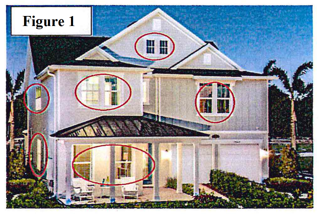
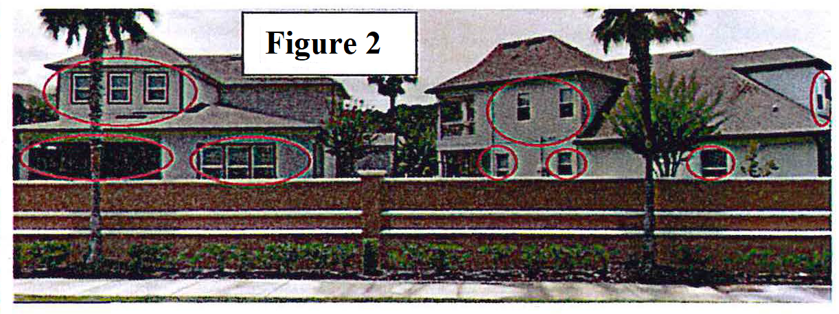
Window and door fenestrations on all sides of structures located along the perimeter of the development or facing a right of way. See Figures 1 and 2.
b.
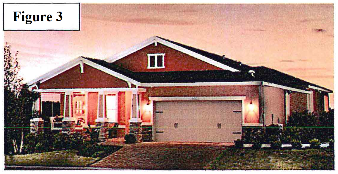
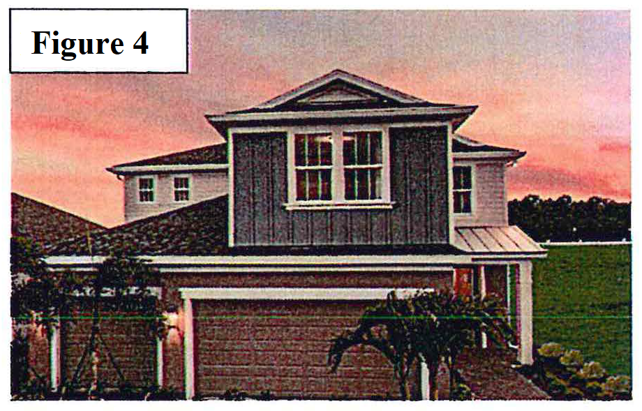
Contrasting color schemes used to create visual depth around windows, doors and building corners. See Figures 3 and 4.
c.
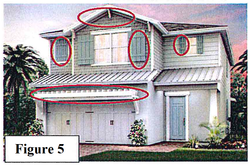
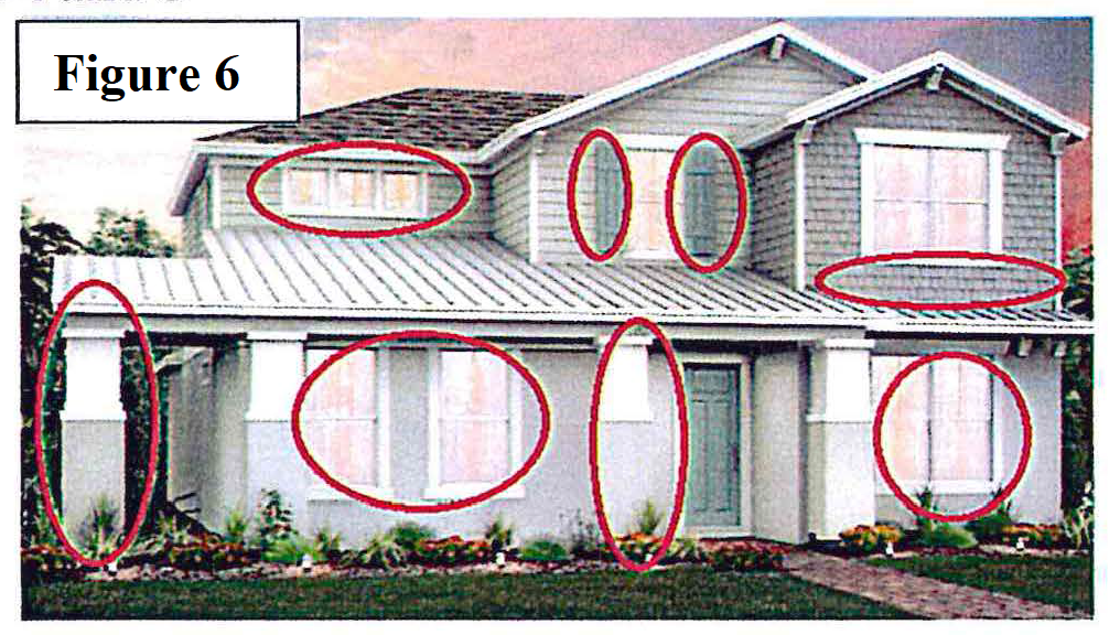
A minimum of one principal window treatment on every elevation (front, side or rear) that faces any right of way (public or private) or open space area that may include, but is not limited to: Pop-outs, decorative wrought iron, wood trim, shutters, plant shelves, and other features or embellishments to vary and soften the visual exteriors. See Figures 5 and 6.
d.
All outdoor mechanical equipment, such as heating, air conditioning, ventilation systems, propane gas tanks, pool equipment and other similar appurtenances shall be located in rear yards on lots with lots less than 7.5 feet on side yard. They shall not be adjacent to the right-of-way whenever possible; if such appurtenances are visible from the right-of-way, they shall be visually screened.
2.
In addition to the required features in B.1 above, a minimum of three of the following design features shall also be required:
a.
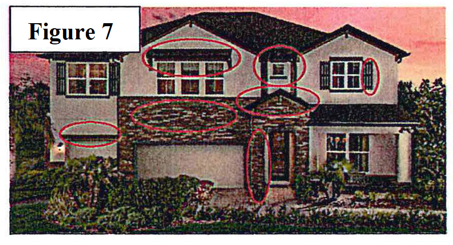
Enhanced corners (pop-outs, embellishments, varying textures etc.). See Figure 7.
b.
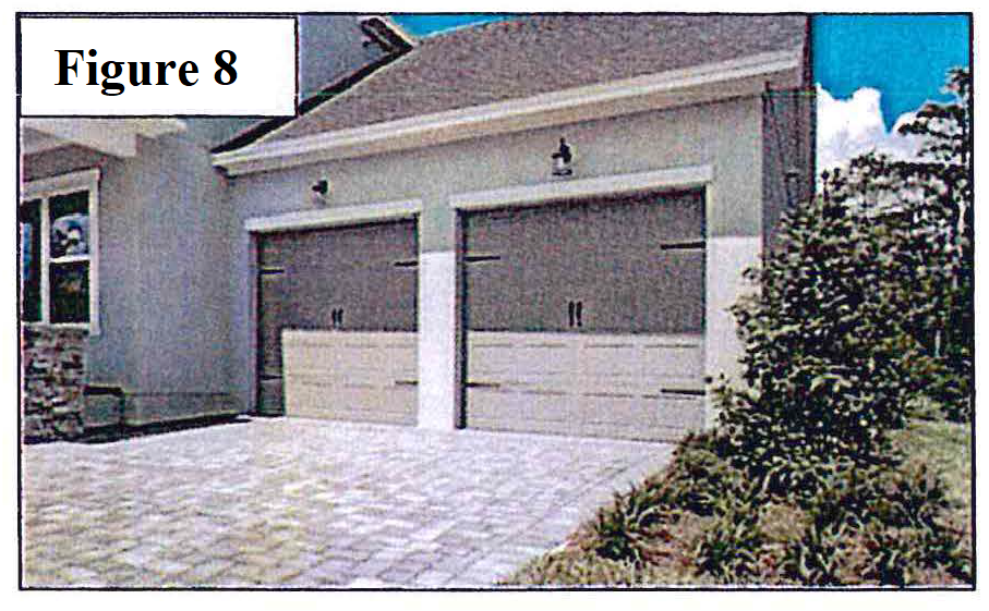
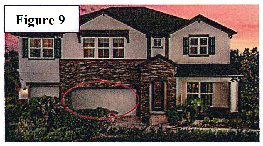
Deep recessed garages. See Figures 8 and 9.
c.
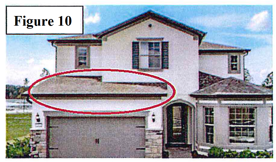
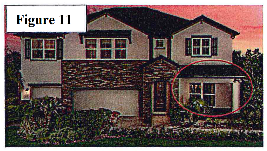
Low roof (first story roofs on multi-level structures). See Figures 10 and 11.
d.
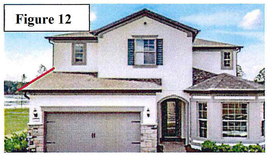
Second story of structure stacked at a greater setback than the first floor to facilitate a first floor feature, especially located immediately above the garage. See Figure 12.
e.
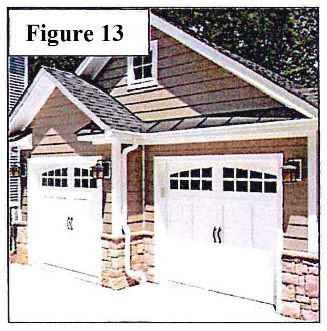
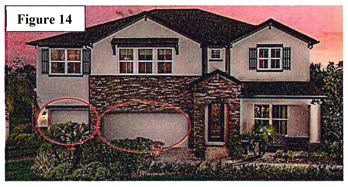
Offset garage doors. See Figures 13 and 14.
f.
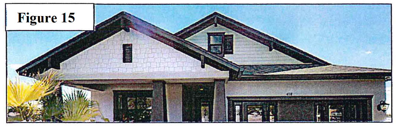
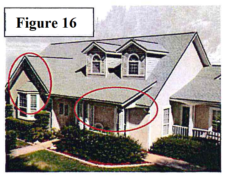
Extended roof overhangs. See Figures 15 and 16.
g.
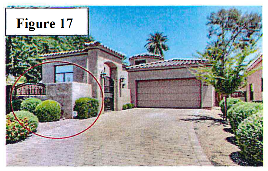
Courtyards (knee walls, and/or decorative wrought iron may be used for courtyard enclosures). See Figure 17.
h.
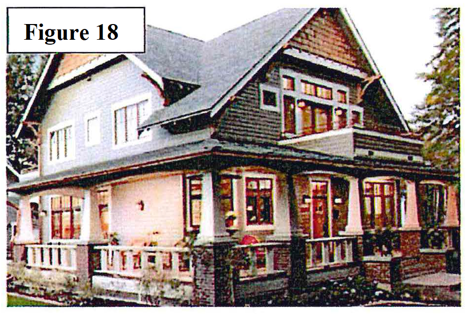
Enhanced window fenestrations on all front elevations and all second story windows facing a right-of-way or open space area shall use principal window treatments per B.1.c. above. See Figure 18.
i.
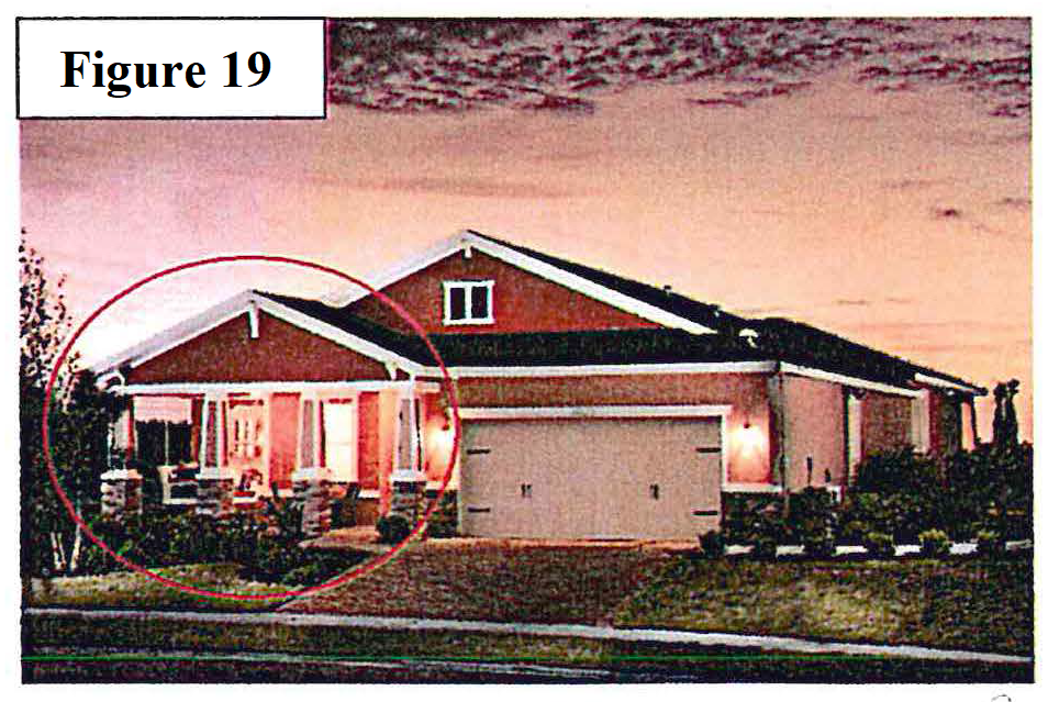
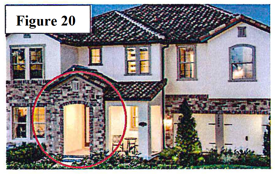
Covered patio, and/or balcony option. See Figures 19 and 20.
C.
Streetscapes.
1.
Sidewalks meeting city standards shall be installed on both sides of the right-of-way.
2.
A minimum of two pedestrian connections to nodes such as a trail system, public facilities, transit stops, or a public street network to promote connectivity.
3.
Lighting shall be required along property line along any open underdeveloped right-of-way leading up to entry of subdivision.
4.
Decorative street lighting. Street and site lighting shall be decorative and blend with the architectural style of the development. Sufficient lighting shall be provided consistent throughout the PD minimizing adverse impacts such as glare and overhead sky glow.
5.
All trees planted near sidewalks shall be planted with deep root barriers to prevent cracked pavements and/or sidewalks; planting trees with tap roots rather than fibrous roots will help eliminate cracking.
D.
Perimeter landscaping. Landscaping shall comply with sections 3.3 and 3.4 of Schedule J, landscape, buffer and tree requirements. In addition, a masonry wall, a minimum four feet in width, shall be constructed along all subdivision perimeter unless otherwise negotiated.
E.
Tree protection. It is prohibited and unlawful to remove or in any way damage any protected tree without first obtaining an arbor permit from the city.
1.
A historic tree is any tree of any size or protected species that has been designated by the city commission as one of notable historical interest and value to the city because of its location or historical association with the community.
2.
A specimen tree is any tree of any protected species with a diameter of 36 inches or greater. The applicant for a permit to remove a specimen tree shall provide findings to the administrative official that the tree is a hazard or that is not economically practically feasible to develop the subject parcel without removing the tree. The administrative official shall consult with the city arborist in making a determination as to removal or if there are viable alternatives to removal.
3.
The PD design must attempt to preserve specimen and historic trees.
4.
No permit for the removal of a protected tree shall be granted unless the developer demonstrates one or more of the following conditions:
a.
A permissible use of the site cannot reasonably be undertaken unless specific trees are removed or relocated.
b.
The tree is located in such proximity to an existing or proposed structure that the safety, utility or structural integrity of the structure is materially impaired.
c.
The tree materially interferes with the location, servicing or functioning of existing utility lines or services.
d.
The tree creates a substantial hazard to motor, bicycle or pedestrian traffic by virtue of physical proximity to traffic or impairment of vision.
e.
The tree is diseased, insect ridden, or weakened by age, abuse, storm or fire and is likely to cause injury or damage to people, buildings or other improvements.
5.
Removed protected trees shall be replaced at a 3:1 ratio with Florida Department of Agriculture Nursery Grade No. 1 or better at the expense of the developer.
F.
Detention and retention ponds. The following landscaping is required.
1.
A decorative and functional fountain shall be installed in all wet retention ponds as part of development approval which approval shall provide for ongoing maintenance requirements and responsibilities upon the appropriate party, but not the city.
2.
Pond configuration shall be incorporated into the natural topography of the site. When not practical, the pond shall be shaped to emulate a natural formed "free form" depression and shall be part of the natural landscape and recreation open space system of the PD.
3.
Plantings shall replicate a natural environment. Trees and shrubs shall be clustered around the basin and contain a variety of plant material.
4.
Trees and shrubs shall be planted in a natural pattern and are not limited to strict placement along the edge of the pond. Trees and shrubs planted below the water line of the pond must be tolerant of wet or moist soil conditions.
5.
Plantings shall be provided as determined by staff review and city commission approval.
G.
Passive and active space requirements. For higher density and smaller residential lots, passive and active space requirements shall be provided based on the following lot sizes:
1.
Common, usable passive and active open space shall be provided per each residential unit based on the following lots sizes:
a.
Lots, 5,000 square feet or greater—200 square feet per lot.
b.
Lots 4,000 to 4,999 square feet—400 square feet per lot.
c.
Lots 3,999 or less square feet—600 square feet per lot.
2.
Passive and active space shall not include improvements required by Code, including but not limited to, the following: Required street landscaping, drives or driveways, streets and sidewalks, parking lots, retention ponds, canals, ditches and drains, and utility or services areas. Buffer and entrance landscaping shall not be included in the open space calculation.
3.
Types of passive and active space. Recreation common open space must provide active recreation open space areas designed for recreation (i.e., picnic area, children's play areas, etc.), but may additionally include passive open spaces. Recreation common open spaces may be comprised of one or more of the following and shall be accessible to all of the residential units it serves:
a.
Courtyard.
b.
Large lawn area; pocket parks; mews.
c.
Playground.
d.
Tennis court.
e.
Basketball court.
f.
Swimming pool.
g.
Splash pad.
h.
Similar outdoor recreation facilities as approved by the city commission.
4.
Greenways, courtyards and open space shall have a minimum 40-foot average width, with a minimum 20-foot dimension.
5.
A pedestrian pathway wall, a minimum five feet in width, shall be provided within the common open space.
6.
Open space shall be recorded as separate tracts owned and maintained by a homeowners' association created in accordance with controlling law.
7.
Alternative amenities may be considered in lieu of the required minimum lot size calculations if determined to enhance the overall design and quality of the development.
H.
Density in residential planned developments; basic density calculations. The total number of dwelling units permitted shall be based on the densities established in the Comprehensive Plan for the underlying future land use category and the JPA.
I.
Table of deviations. A table and written justification shall be provided on the site plan, which specifically details all deviations from the comparable established zoning district's lot area, height and setback regulations, off-street parking regulations, subdivision regulation or other zoning provisions, which would otherwise be applicable including mitigating enhancements.
(Ord. No. 4511, § 1(Exh.), 10-14-2019)