Sanford City Zoning Code
Schedule U
OVERLAY DISTRICTS1
Editor's note— Ord. No. 4337, § 2, adopted March 23, 2015, amended Schedule U in its entirety to read as herein set out. Former Schedule U, §§ 1.0—3.0, pertained to Overlay Districts. See the Code Comparative Table for complete derivation.
Section 1.0.- Purpose and applicability.
An overlay district is a defined geographic area that, due to its unique character, quality, resources or needs warrants specific recognition and/or management through the use of special standards and regulations. The special standards and regulations are in addition to the underlying zoning regulations and standards. Where there is a conflict between the zoning regulations and the overlay district regulations, the overlay district regulations apply.
The provisions of this schedule shall apply to the entire parcel when all or a portion of a proposed development, or modification thereto, is located in an overlay district.
(Ord. No. 4337, § 2, 3-23-2015)
Section 2.0. - Lake Mary Boulevard and West S.R. 46/Rinehart Road Overlay Districts.
A.
Applicability.
Lake Mary Boulevard - The Lake Mary Boulevard overlay district includes all lands located within the Sanford city limits that lie within 320 feet of the centerline of Lake Mary Boulevard between the CSX Railroad Line near Country Club Road and the intersection of State Road 46 and County Road 415. If any part of any parcel abuts the right-of-way line of the designated roadway, the entire parcel shall be subject to this part as if the parcel were wholly within the stated corridor.
West S.R. 46/Rinehart Road Gateway - The S.R. 46/West First Street overlay district includes all lands located within the Sanford city limits that lie within 320 feet of the centerline of S.R. 46 between the Interchange at I-4 and Airport Boulevard (existing) and Rinehart Road. If any part of any parcel abuts the right-of-way line of the designated roadway, the entire parcel shall be subject to this part as if the parcel were wholly within the stated corridor.
B.
Purpose. The purpose of this overlay district is to insure that these gateway corridors are developed in a manner which:
1.
Insures the roadway is developed into a well landscaped, scenic gateway;
2.
Provides uniform design standards to establish high quality development;
3.
Prevents visual pollution caused by unplanned and uncoordinated uses, buildings and structures;
4.
Maximizes traffic circulation functions from the standpoint of safety, roadway capacity, vehicular and non-vehicular movement;
5.
Maintains and enhances property values;
6.
Preserves natural features to the extent practicable; and
7.
Recognizes and makes allowances for existing uses and buildings.
C.
Building setbacks. The front yard building setback shall be a minimum of 50 feet. Such front yard building setback shall be greater than 50 feet if a more restrictive setback is required as set forth in this ordinance, as part of a stipulation or condition of development, or as required in Schedule C.
D.
Street-side landscape buffer.
1.
Lake Mary Boulevard.
a.
A minimum 15-foot landscape buffer, or greater if provided by this ordinance, shall be provided in the area abutting the designated roadway right-of-way lines. Landscape buffer width may be reduced to a minimum of ten feet only if the lot or tract is less than 200 feet in depth.
b.
The developer/property owner shall be responsible for the purchase, installation, maintenance and irrigation of all required landscaping.
c.
The landscape buffer area shall be planted with live oaks, of four-inch diameter 12 inches above grade at planting, along a line ten feet back from the right-of-way line. The trees shall be planted every 40 feet and staggered so as to be midway between any live oaks planted in the adjacent right-of-way. A minimum of four sub-canopy trees per 100 feet of frontage shall be planted in and about access points and intersections. Unless otherwise noted herein, all landscaping shall comply with Schedule J, Landscape, Buffer and Tree Requirements of the Sanford land development regulations including landscape materials planted under power lines.
d.
No existing, dedicated or reserved public or private right-of-way shall be included in calculation of the buffer width.
e.
The corridor buffer area may include minor storm water retention features only.
f.
If parking abuts the buffer, a continuous shrub hedge shall be arranged or planted so that a height of three feet will be attained within one year of planting so as to screen a minimum of 75 percent of the parking area, to that height, as viewed from the right-of-way.
g.
Existing vegetation may be used to meet these requirements.
2.
West S.R. 46 and Rinehart Road.
a.
A minimum 25-foot landscape buffer, or greater if provided by this ordinance, shall be provided in the area abutting the designated roadway right-of-way lines. Landscape buffer width may be reduced to a minimum of 15 feet only if the lot is less than 200 feet deep.
b.
The developer/property owner shall be responsible for the purchase, installation, maintenance and irrigation of all required landscaping.
c.
The landscape buffer area shall be planted with two rows of live oaks, of four-inch diameter 12 inches above grade at planting. The trees shall be planted every 50 feet and staggered so as to be midway between each other, and equal distance between each row and right-of-way. A minimum of four sub-canopy trees per 100 feet of frontage shall be planted in and about access points and intersections. Unless otherwise noted herein, all landscaping shall comply with Schedule J, Landscape, Buffer and Tree Requirements, of the Sanford land development regulations including landscape materials planted under power lines.
d.
No existing, dedicated or reserved public or private right-of-way shall be included in calculation of the buffer width.
e.
The corridor buffer area may include minor storm water retention features only.
f.
If parking abuts the buffer, a continuous shrub hedge shall be arranged or planted so that a height of three feet will be attained within one year of planting so as to screen a minimum of 75 percent of the parking area, to that height, as viewed from the right-of-way.
g.
Existing vegetation may be used to meet these requirements.
E.
Parking. Parking lots shall be designed and landscaped according to the following criteria:
1.
A minimum of ten percent of all parking area and entryways shall be landscaped. Landscape material shall be selected from the list of plants in Appendix 1 of Schedule J.
2.
Parking bays shall not be larger than 40 spaces.
3.
Landscape breaks. Perimeter landscaped parking breaks shall be a maximum of 200 square feet in area, planted with one canopy tree and a maximum of 20 spaces apart.
a.
Internal landscaped breaks shall be a minimum of 400 square feet planted with one canopy tree, two to three inches in diameter 12 inches above grade, for every landscape break and a minimum of three shrubs for every landscaped break. Internal breaks shall be a maximum of 20 spaces apart.
b.
Diamond landscaped breaks shall be placed every ten spaces internally, shall be eight feet by eight feet and shall be planted with one canopy tree.
c.
Preservation. Existing vegetation may be used to meet these requirements.
4.
Lighting. Parking lot lighting shall be designed as follows: Illumination onto adjacent properties shall not exceed 0.5 foot-candles. Cut-off fixtures are required to conceal the actual source of the light which reduces glare and to direct the light to specific areas while shielding other areas. The maximum height of the light pole shall be 25 feet, including the base. The minimum setback of the light source from the property line shall be a horizontal distance of 20 feet.
F.
Utility lines. All new or relocated utility lines within the designated corridor shall be constructed and installed beneath the surface of the ground unless it is determined by the city that soil, topographical, or any other compelling conditions, make the underground installation of such utility lines as prescribed herein unreasonable and impracticable.
G.
Walls. All freestanding walls, sound barriers, ground sign enclosures, planters, etc. fronting along the designated roadway or its major intersections shall be of brick or half-block. Alternate entrance features such as stone, metal, wood, etc. may be approved by the planning and zoning commission.
H.
Residential exempted. All residentially zoned single family lots are exempted from meeting all standards contained in this schedule except for the burial of utility service lines, wall requirements and the building setback requirement.
(Ord. No. 4337, § 2, 3-23-2015; Ord. No. 4589, § 1(Exh.), 2-8-2021)
Section 3.0. - Downtown/Riverfront/Midtown Overlay Districts.
The following sections regulate specific areas within the City of Sanford. Design components within the special districts have been crafted to provide options for development that will allow for innovative traditional design development with the creation of three new overlay districts: Riverfront Overlay District, Midtown Overlay District and Downtown Overlay District. The criteria shall be strictly adhered to in order to maintain the vision for the City of Sanford. The standards will encourage connections between the waterfront, shopping, working and residential areas.
A.
Definitions. The following words, terms and phrases, when used in this division, shall have the meanings ascribed to them in this section, except where the context clearly indicates a different meaning.
Alley. A public or private way permanently reserved as a secondary means of access to abutting property.
Anchor tenant. A retail store(s) in a shopping center that is/are in excess of 15,000 square feet of gross floor area and possess at least 100 feet of building frontage.
Block. A unit of land bounded by streets or by a combination of streets and public land, railroad rights-of-way, waterways, or any other barrier to the continuity of development.
Block face. The area of the block which faces a street.
Building frontage. The horizontal length of a wall of a building where such wall faces a street. The measurement of such length is along a line parallel to the street. Where a building is arranged to include establishments with exterior public entrances but no wall space facing a street, the horizontal dimension of one wall of each such establishment which faces a mall or other private way may be considered to be building frontage.
Building height. The limit to the vertical extent of a building. The building height may be prescribed as a maximum number of stories or as a dimension from sidewalk grade to the eave. The height limit shall not apply to attics, raised basements, chimneys, machine rooms, or similar structures. Decorative elements may exceed the total height of the structure by no more than ten percent of the total height of the building for structures greater than four stories and by no more than 20 percent for structures four stories and less.
Building scale. The relationship between the mass of a building and its surroundings, including the width of street, open space, and mass of surrounding buildings.
Building setback, front. The distance from the street right-of-way line to the closest point of the foundation of a building or projection thereof.
Common open space. Squares, greens, neighborhood parks, and linear environmental corridors.
LEED. The Leadership in Energy and Environmental Design (LEED) Green Building Rating System TM is the nationally accepted benchmark for the design, construction, and operation of high performance green buildings. LEED promotes a whole-building approach to sustainability by recognizing performance in five key areas of human and environmental health: sustainable site development, water savings, energy efficiency, materials selection, and indoor environmental quality.
Live/work unit. Accommodates residents in addition to work activities. As a minimum, a live/work unit will need to provide residential facilities equivalent to those provided in what is variously described as an efficiency unit or a studio apartment.
Lot width. The horizontal distance between side lot lines measured at the front setback.
Mass. Determined by the three-dimensional bulk of a structure: height, width, and depth.
Parapet. The extension of a false front or wall above a roof line.
Podium. In a high density mixed use development building, the first three stories shall be considered the podium portion of the building.
Principal building. A building in which the primary use of the lot on which the building is located is conducted.
Story(ies). The permitted total height of a building that is calculated by a maximum of 14 feet per story. This can be averaged by total stories and not required by floor.
Structure, mixed-use. The combination of both commercial and residential uses within a single building of two or more stories, wherein at least 33% of the heated floor area contains residential dwelling unit(s).
Structure, single-use. A single use is in a building.
Tower. The high density mixed use prototype building's fourth story and higher stories shall be considered the tower portion of the building.
Traditional neighborhood. A compact, mixed use neighborhood where residential, commercial and civic buildings are within close proximity to each other.
B.
Applicability of other sections of the land development code. In addition to the standards provided herein, development within the special area districts shall be required to meet all other applicable sections of the land development code. Where any provision of the downtown/riverfront design standards is in conflict with any other standards or regulations of the land development code, the downtown/riverfront standards shall prevail.
The provisions of Section 15, Urban Infill, of Schedule E may not be applied to any parcels within the downtown/riverfront/midtown areas.
For those parcels located in the historic commercial district, the provisions of Schedule S shall prevail, unless otherwise noted in this schedule.
Developments within the downtown overlay district, the riverfront overlay district and the midtown overlay district may be approved through the planned development process. The design of planned developments shall adhere to traditional design development and shall generally conform to the downtown/riverfront overlay standards for block development, site design, lot layout, prototype design, and building design. Any deviation from the standards of this ordinance shall result in a development that is beneficial to the city, enhances the character of the community in which it is located and is superior to a project that is designed consistent with the downtown/riverfront overlay standards.
The maximum height of structures on Marina Isle is 90 feet as measured from sidewalk grade to the rooftop including attics, mechanical equipment and raised basements. Decorative elements may exceed the total height of the structure by no more than ten percent of the total height of the building for structures greater than four stories and by no more than 20 percent for structures four stories and less.
C.
District intent statements. The following three overlay districts are based on the key principles of urban type development, which are walkable and designed to contain a diverse range of housing, shopping and offices. All three districts will offer design standards for development that provide for an efficient land use form and cost-effective delivery of urban services.
1.
Riverfront Overlay District (RF). The purpose of this district is to provide for a mixed-use area for high-density residential, offices and retail uses.
2.
Midtown Overlay District (MT). The primary purpose of this district is to encourage residential uses. This district provides for a mixed-use area for single-family, multifamily housing, offices and neighborhood serving retail, where appropriate, and is not in direct conflict with the residential usage.
3.
Downtown Overlay District (DT). The primary purpose of this district is to encourage commercial uses. This district provides for a mixed-use area for single-family, multifamily housing, hotel, offices and retail, where appropriate, and is not in direct conflict with the residential usage and the historic district.
D.
Designation of street type. The downtown/riverfront standards designate three street types that exist within the downtown/riverfront area. The identification of each street type directly relates to the site design and lot layout criteria outlined in these standards.
1.
Designation of "A" streets, "B" streets and "pedestrian priority" streets:
a.
The following table designates existing streets within the downtown/riverfront area as an "A" street or a "pedestrian priority" street. Streets not specifically designated will be considered "B" streets. The creation of new streets constructed on or after the effective date of this ordinance will be updated and designated by the city.
b.
"A" streets shall have building frontage requirements, established build-to lines and active retail on first floor, restricted parking and service uses adjacent to an "A" street.
c.
"Pedestrian priority" streets shall have building frontage requirements, established build to lines, restrict parking and service uses adjacent to a "pedestrian priority" street.
d.
"B" streets shall have no building frontage requirements. While "B" streets are not intended to be primary pedestrian streets, additional provisions on architectural details, accessory structures, and service bays will be provided. All streets west of French Avenue are "B" streets.
Table 1: Street Designation
E.
Permitted development types. In order to reinforce the Downtown/Riverfront Area, new development shall be organized into development blocks.
Development activity shall be regulated through these standards and shall be required to comply with the comprehensive definition of permitted development included herein that regulates use, density, intensity, and form by requiring development to occur within one of the following development block types:
1.
Single-use commercial development.
2.
Mixed-use development:
a.
Office/neighborhood commercial.
b.
Retail development.
c.
High density development.
3.
Attached and detached residential development.
4.
Transitional mid-block residential development.
5.
Infill development.
The block types shall be used for illustrative purposes. Development applications for specific sites are required to assemble structures into mixed-use blocks or half-blocks, as appropriate, for the site. Each site plan shall be required to identify how the proposed development, including buildings and structures, are assembled within a context that conforms to the design standards for the block or half-block within which the building occurs.
The development block structure reinforces the Downtown/Riverfront's existing block structure and street network by limiting block size and framing the development block within the existing street system. This block structure is designed to create a walkable community through a set of block standards and requirements for site design, lot layout and building design. The following table identifies each block type and denotes a "P" for permitted and "NP" for not permitted.
Table 2: Permitted Development Types
F.
Site design and lot layout. Examples of permitted development types are described for illustrative purposes. Each site plan shall be required to identify how the proposed development, including buildings and structures, is assembled within a context that conforms to the design standards for the block or partial block within which the building occurs.
The development examples are a series of illustrations that highlight some of the downtown/riverfront standards. The illustrations are shown in a block format and individual parcel development may not be able to build to the form of a block. However, all development, at a minimum, will be expected to comply with the building design, site design and lot layout as described in these design standards. If development of an entire block occurs, the illustration shall be used as a development tool. Any new development that is at least two acres in size shall follow the block structure. The maximum permitted block size for new development shall not exceed 350 feet by 600 feet. The Administrative Official or his designee may permit a varying block size provided site constraints exist and the maximum block size must be maintained by pedestrian access and breaks on the first floor.
1.
Single-use commercial development. The single-use commercial illustration, figure A, permits a wide range of commercial uses.
a.
Height. One to four stories not to exceed 56 feet.
b.
Setbacks. The minimum front setback is zero feet and the maximum setback is 15 feet. Side setbacks shall be the same as the front setbacks.
c.
Setback encroachment. Special architectural features, such as balconies, bay windows, arcades, awnings, etc. may project into front setbacks and public rights-of-way on streets provided they are eight feet above the sidewalk and leave a minimum five-foot wide unobstructed sidewalk. Support structures for these features shall be located such that they do not affect the clear sight triangle for travel lanes or the on-street parking. Prior to new encroachment into the public right-of-way, a permit shall be obtained from the administrative official or designee.
2.
Mixed-use development. Mixed-use development examples are designed to accommodate a range of retail, office and mixed-use building types. Mixed use developments include:
a.
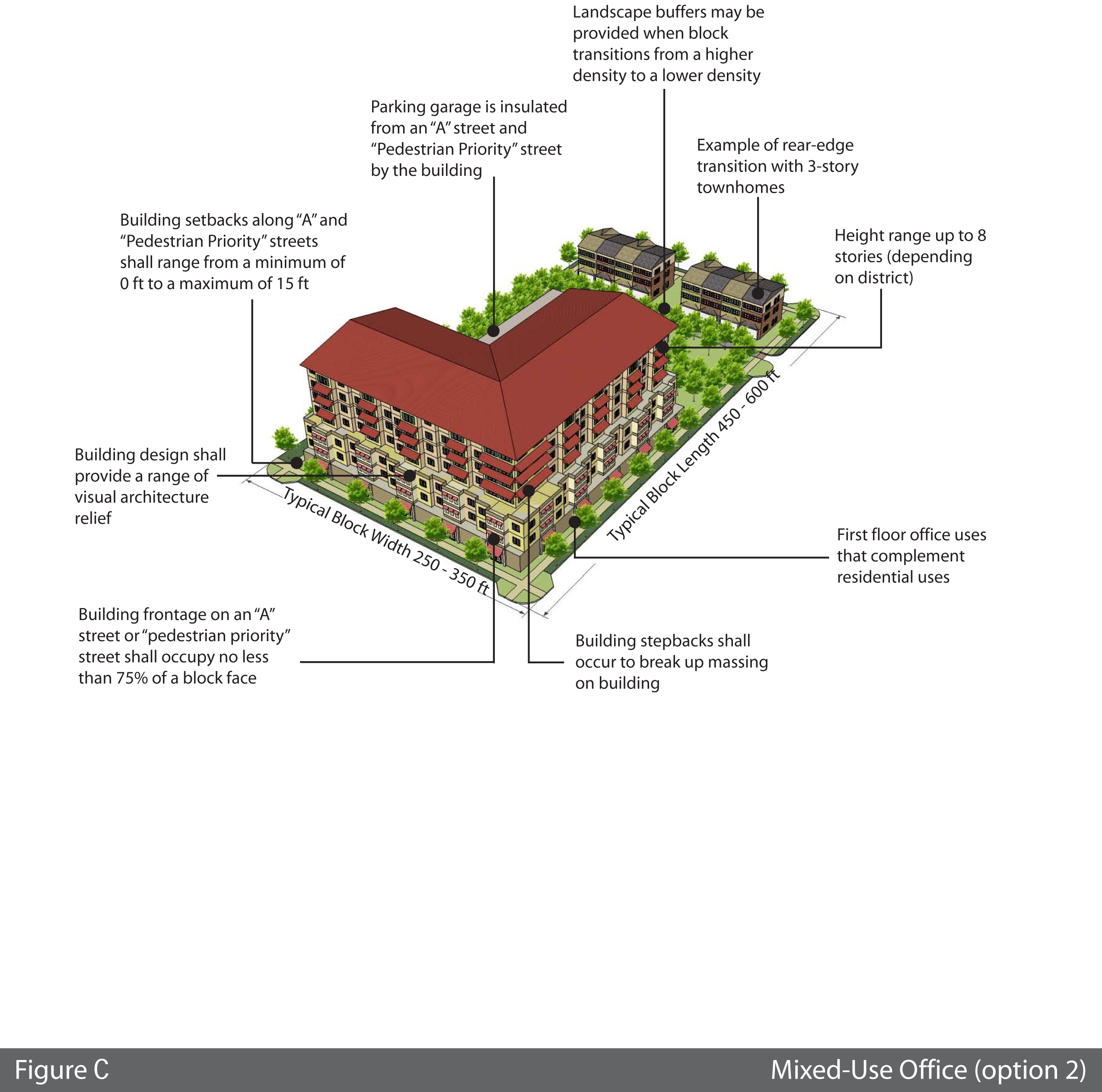
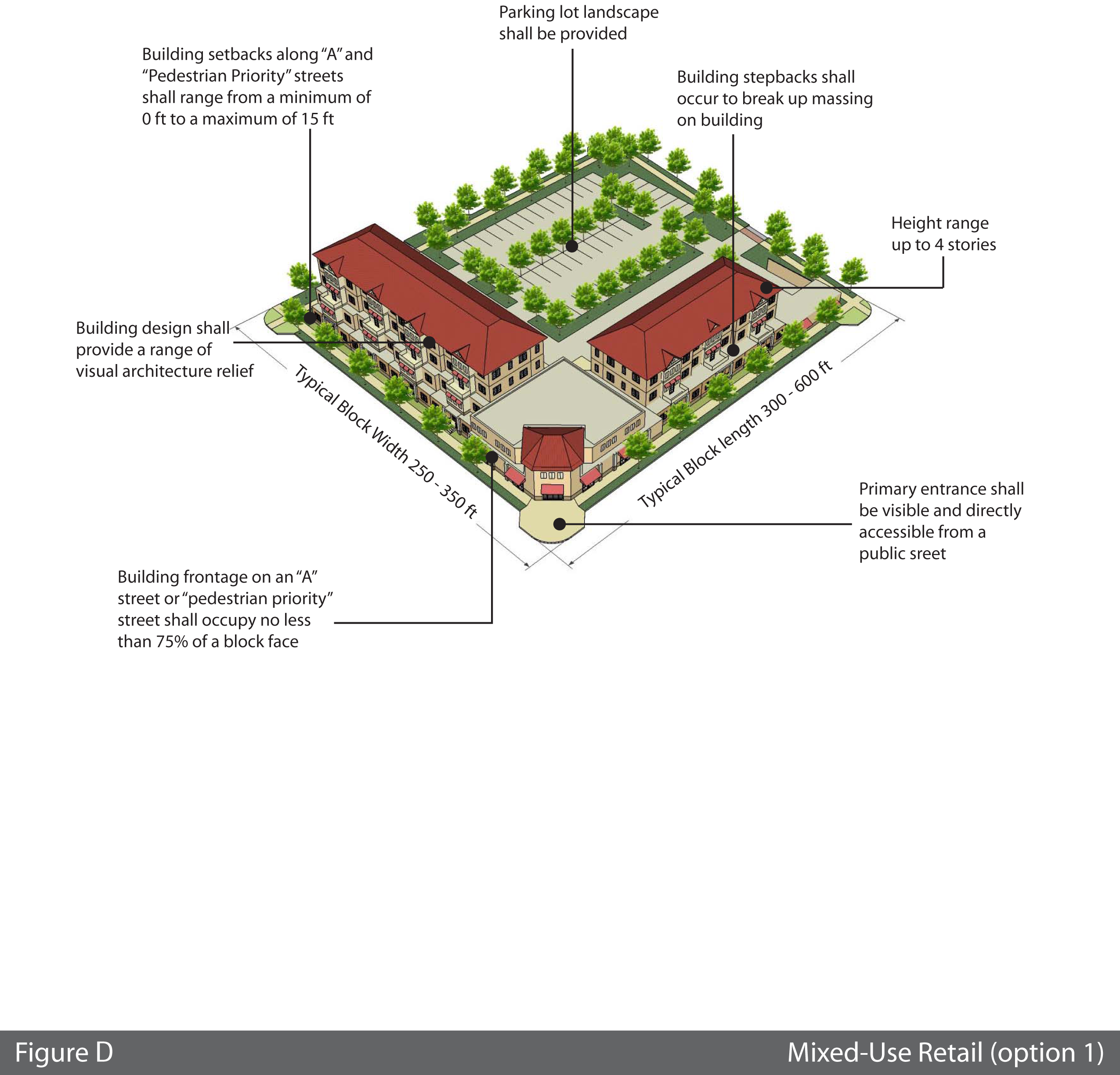
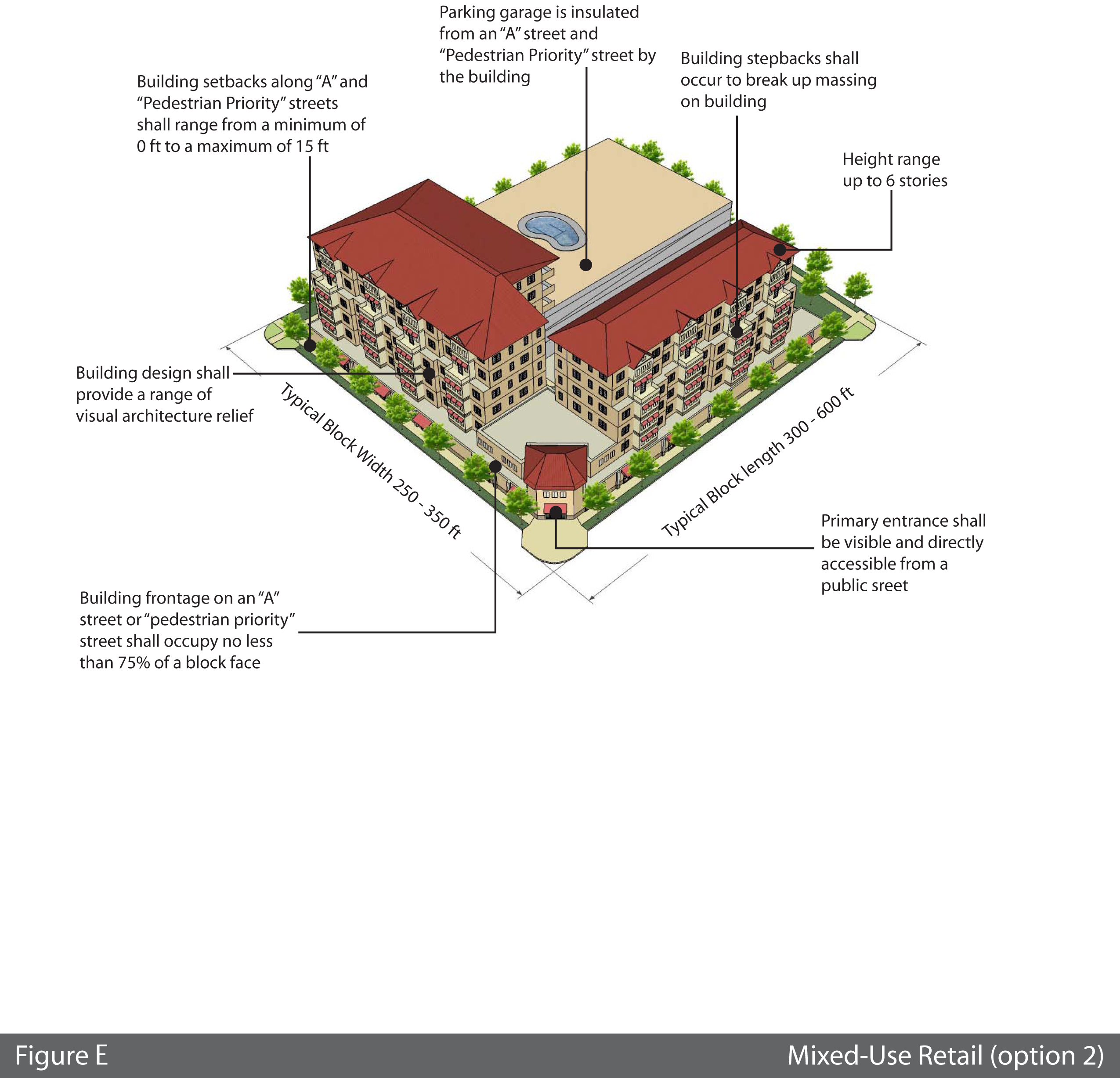
Retail option one and option two, Figures D and E and office/mixed-use option one and option two, figures B and C.
i.
Height. Option one maximum height is four stories not to exceed 56 feet and option two is eight stories not to exceed 112 feet with the following provisions:
• The distance from existing single family residential zoning must be at a minimum of 300 feet.
• The fourth story shall be set back ten feet from the third story. This setback shall occur from any street side façade of the building.
• Midtown Overlay District (MT) and Downtown District (DT) permits six stories and the Riverfront Overlay District (RF) permits eight stories. The additional stories are permitted if the building is Leadership in Energy and Environmental Design (LEED) certified and/or Florida Green Building Council (FGBC) certified.
ii.
Setbacks. The front setbacks are a minimum of zero feet and a maximum of 15 feet. Side setbacks shall be the same as the front setbacks.
iii.
Setback encroachment. Special architectural features, such as balconies, bay windows, arcades, awnings, etc. may project into front setbacks and public right-of-ways on streets provided they are eight feet above the sidewalk and leave a minimum five-foot wide unobstructed sidewalk. Support structures for these features shall be located such that they do not affect the clear sight triangle for travel lanes or the on-street parking. Prior to new encroachment into the public right-of-way, a permit shall be obtained from the city commission or its designee.
3.
High density mixed-use development, Figure F.
a.
Height. Permitted height shall be six stories not to exceed 84 feet with a bonus of up to an additional two stories not to exceed 28 feet, totaling no more than eight stories not to exceed 112 feet is permitted with the following provisions:
• To receive the bonus stories, the building must be Leadership in Energy and Environmental Design (LEED) certified and/or Florida Green Building Council (FGBC) certified.
• The podium portion of the building shall be three stories in height.
• All stories over three shall be considered the tower. A tower's maximum lineal dimension may not extend more than 200 feet. If two towers are located on the podium, the required distance between the towers shall be determined by one-third of the height of the tallest tower.
b.
Additional permitted height. In addition to the permitted eight stories, an additional four stories not to exceed 168 feet is permitted provided the following condition occurs: The determination of the additional amount of stories will be determined by the permitted density and the location of the proposed additional height. An additional four stories (9 th , 10 th , 11 th and 12 th story) may be granted if the parcel is located west of French Avenue or north of Fulton Street on the east side of French Avenue and not adjacent to any single family residential zoning district.
c.
Setbacks. The front and side setbacks are a minimum zero feet and a maximum of 15 feet.
d.
Setback encroachment. Special architectural features, such as balconies, bay windows, arcades, awnings, etc. may project into front setbacks and public right-of-ways on streets provided they are eight feet above the sidewalk and leave a minimum five foot wide unobstructed sidewalk. Support structures for these features shall be located such that they do not affect the clear sight triangle for travel lanes or the on-street parking. Prior to new encroachment into the public right-of-way, a permit shall be obtained from the administrative official or designee.
4.
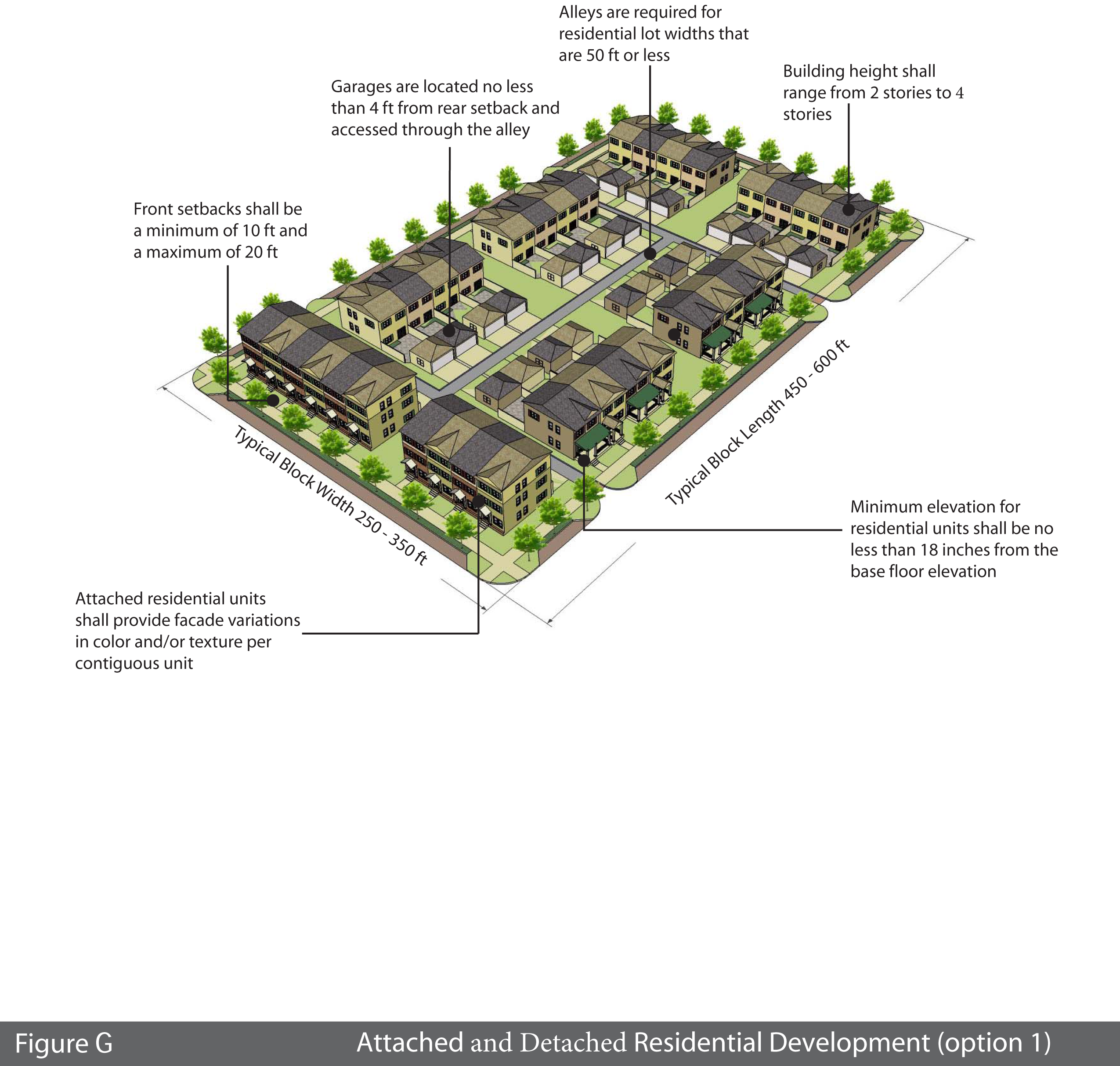
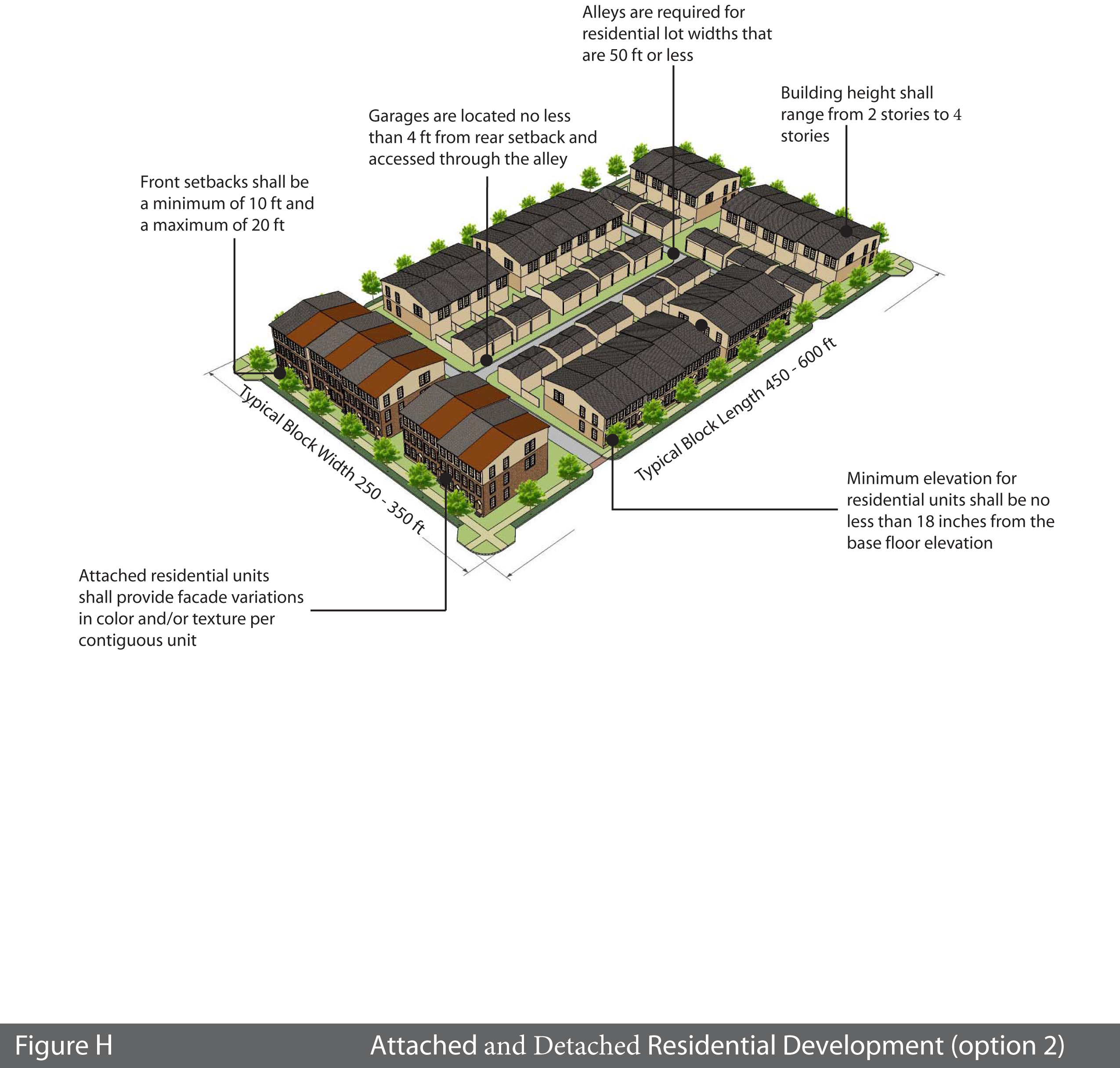
Attached and detached residential development. Residential development illustrations, figure G and figure H. This residential development block is designed to accommodate a range of single-family and multi-family building types including apartment buildings, condominiums, single-family detached houses and town homes.
a.
Elevation. The minimum elevation shall be 18 inches from the base flood elevation.
b.
Height. The minimum height shall be two stories not to exceed 28 feet and the maximum height is four stories not to exceed 42 feet.
c.
Setbacks. The minimum front yard setback is ten feet and the maximum is 20 feet. The side yard setback on the corner lots shall be maintained consistent with the front yard setback. Garage and accessory units located in the rear of the parcel shall be set back a minimum of four feet from an alley and ten feet when an alley is not constructed.
d.
Setback encroachment. Front porches may encroach up to ten feet in a 20 foot setback and up to five feet in a ten foot setback.
e.
Alleys. Alleys are required to be constructed with lots sizes smaller than 50 feet in width.
f.
Garages. Street-facing ground floor parking, including garages, is not permitted on the first floor of a multifamily structure on an "A" street or a "pedestrian priority" street. Parking shall occur underneath the multifamily structure, within parking garages, or within surface lots that do not front on either an "A" street or a "pedestrian priority" street.
i.
Architectural detailing shall remain consistent on all elevations of the primary building as viewed from both the front street and side street elevation.
ii.
Front garages must be set back a minimum of five feet from the primary structure.
iii.
Rear garages must be set back a minimum of four feet from an alley or rear access drive. On corner lots on "A" or "pedestrian priority" streets with alley access, garage doors shall not face side streets.
iv.
Side garages may have an access from the street and are required, at a minimum, to be set back in line with the primary structures side setback.
v.
Ground floor parking, including garages that are located inside the internal block are permitted on the first floor of a structure if the street facing side view of the garage blends in with the design elements of the building's primary frontage.
5.
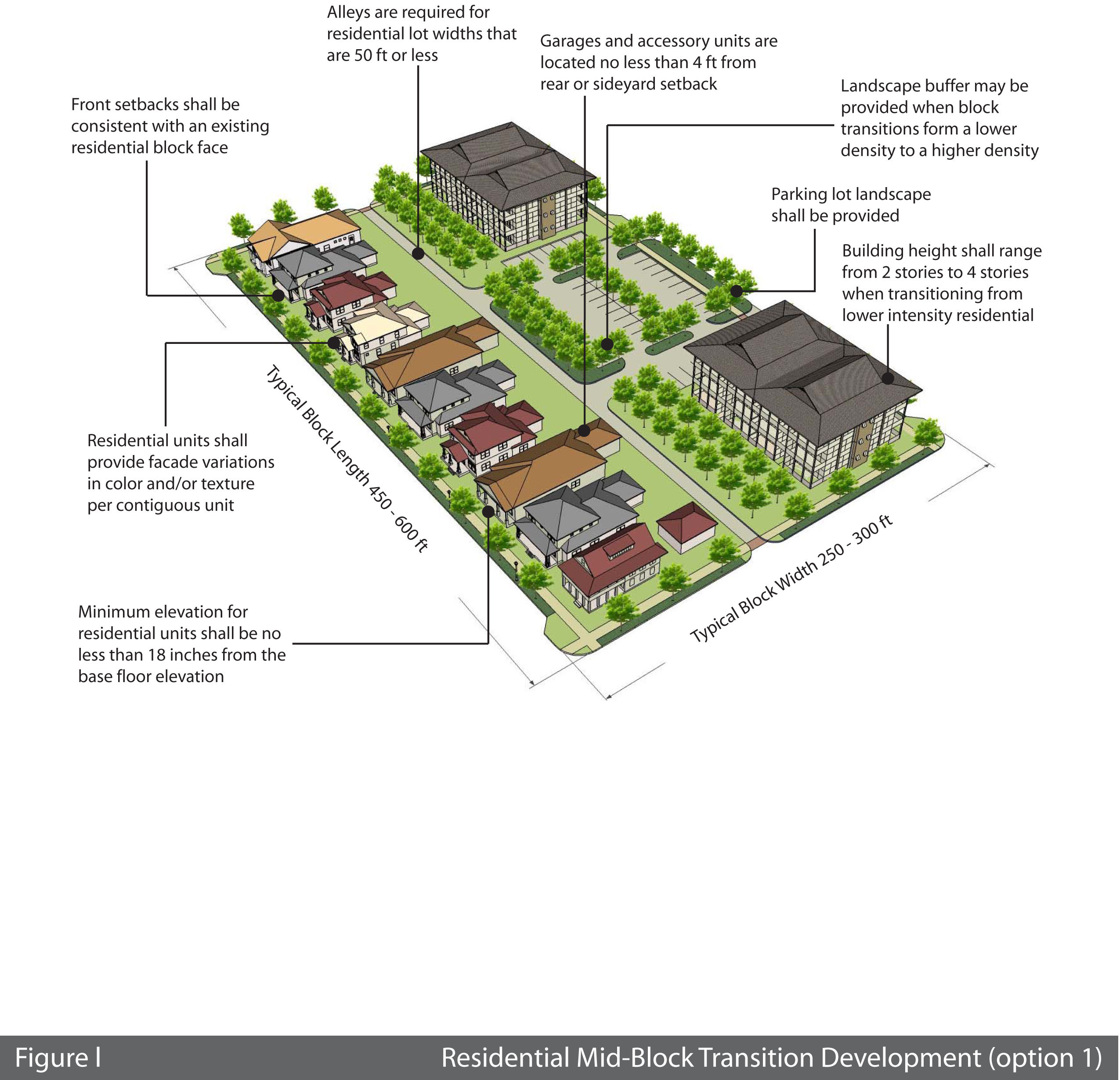
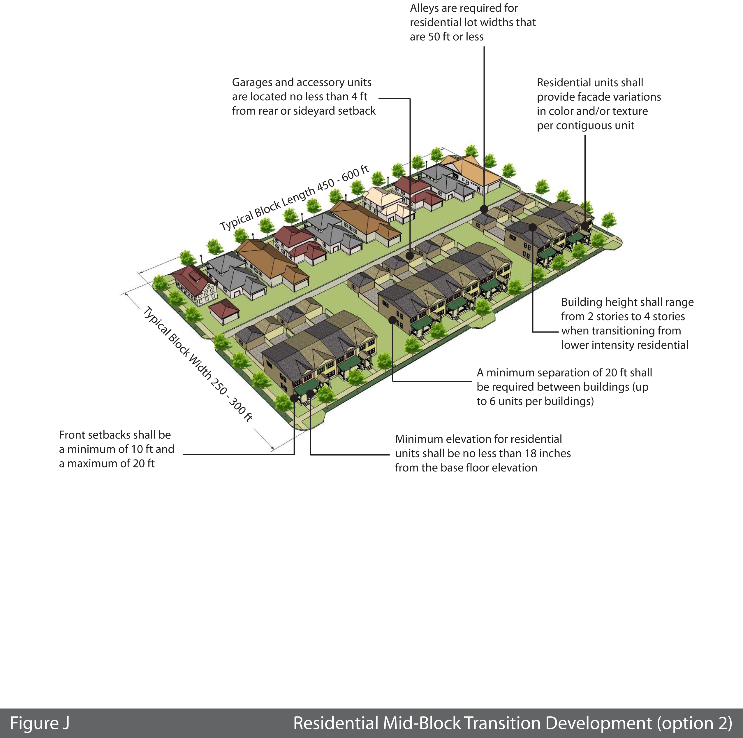
Transitional residential development. (figures I and J) Transitional development blocks shall be applied to any development over two stories in height that is adjacent to single-family residential zoning. The block facing a single-family residential zoning shall be single-family detached housing that is compatible with existing residential. The mid-block portion of the block may transition up to four stories not to exceed 56 feet with the following provisions:
a.
Setbacks. The setback shall be determined by the existing residential uses that are facing the proposed residential uses. The setback may be varied up to five feet from the average of the existing residential units. The structures that are more intense than single-family housing shall follow the appropriate development block as detailed in these design standards.
b.
Landscape buffer. A landscape buffer of 20 feet may be required as determined by the administrative official or his designee.
c.
Lighting. The proposed development shall also control the effects of lights from automobiles or other sources. Where the site plan indicates potential adverse effects from parking or from other sources on the lot on which the non-residential use is to be located, such effects shall be illuminated, or at a minimum, prevented so that lights do not illuminate adjacent residential property below a height of five feet at the residential property line, or from shining into any residential window if there is to be non-residential parking on the premises after dark.
d.
Rear yard setback. When a non-residential use or multi-family (apartment) use is abutting any single-family residential property, there shall be an additional setback required for any yard of that use which is contiguous to the residential property, as follows:
• When the rear side of a single story structure equal to or less than 25 feet in height abuts single-family residential zoned property, that portion of the structure(s) shall be set back at a minimum 20 feet from the rear property line.
• When a single story structure equal to or less than 25 feet in height abuts the side of a single-family residential zoned property, the structures shall be a minimum of 20 feet apart.
• Trash receptacles and loading facilities may not be permitted in the rear of the property. Service areas shall be located on the side. Exceptions to the location shall be determined by the location of the adjacent single-family residential use.
• When any side of a structure greater than one story or 25 feet in height abuts residential property, that portion of the structure shall be set back at a minimum of 30 feet from the property boundary.
• Building design. The side of the building that is facing or backing up to any residential development must be treated with the same architectural design standards as the front of the building.
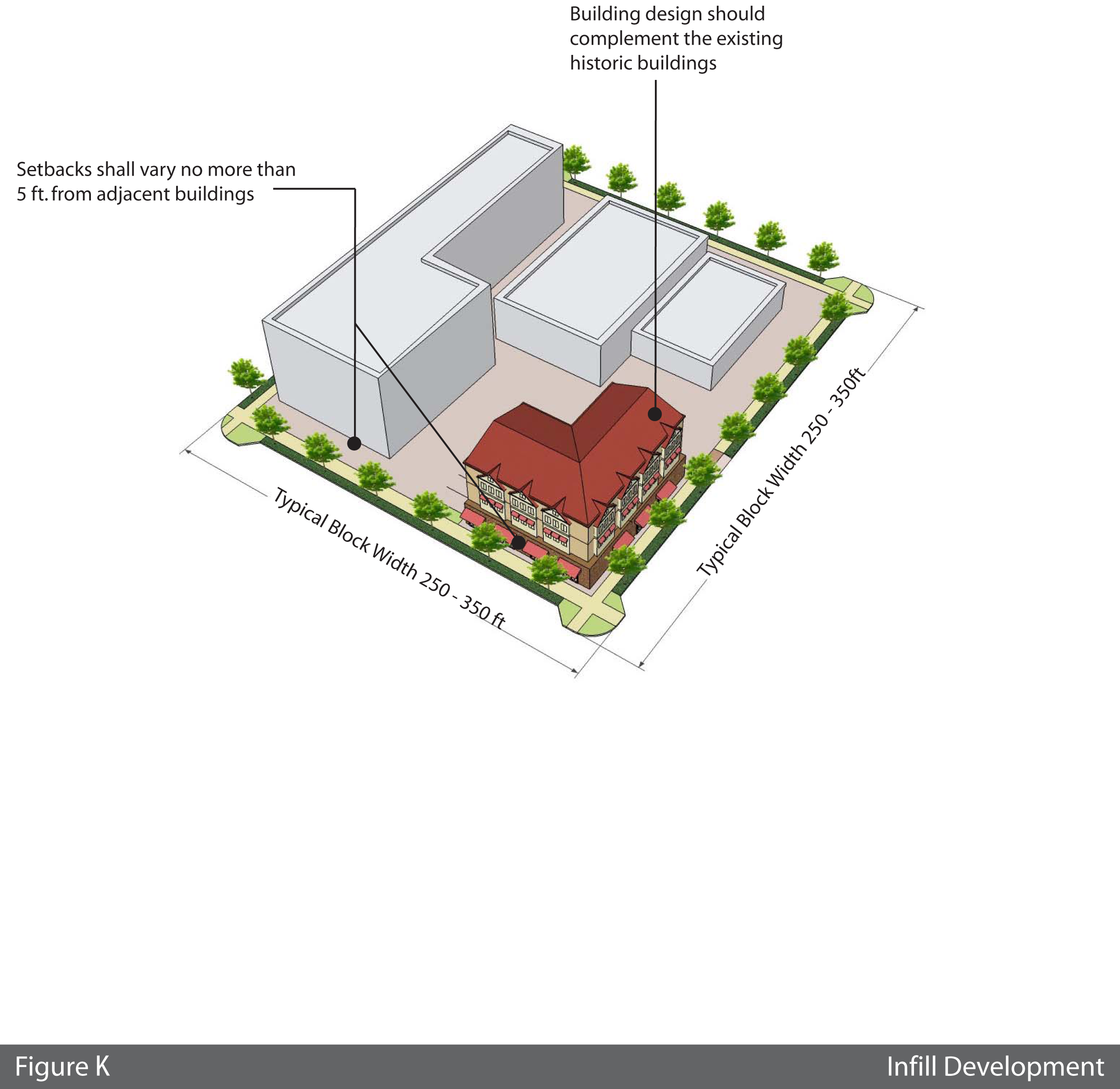
6.
Infill development. The infill development illustration, figure K, illustrates a single building within an existing built-out block.
a.
Setbacks. The setback shall be determined by the existing adjacent structure(s). It will be permitted to vary the setback up to five feet from the average of the existing structure.
G.
General block standards.
1.
General site design.
a.
Form. Buildings shall form a consistent, distinct edge, spatially delineating the public street through maximum building setbacks that vary by no more than five feet from those of the adjacent building.
b.
Open storage. There shall be no open storage.
c.
Sidewalks. All buildings or developments must provide sidewalks along the street edge(s) of their property. Sidewalks shall be constructed to align with existing sidewalks and the materials shall complement the existing sidewalk materials. Sidewalk connections from the principal building to the public sidewalk must be provided.
d.
Landscaping. Landscaping adjacent to existing and proposed street sidewalks must be compatible with the city's existing streetscape standards.
e.
Utilities. All utilities shall be located underground.
2.
Off-street parking (surface parking lots).
a.
A knee wall shall be constructed for the length of any parking lot which fronts a "pedestrian priority" or an "A" street. The knee wall shall be constructed using the following standards:
(i)
Minimum two feet in height to a maximum of three feet.
(ii)
The knee wall must be masonry or brick which complements the primary building's architecture by utilizing the same architectural style.
b.
A maximum of two vehicular access/curb cuts to parking lots are allowed along "A" street block faces, subject to access management regulations of Schedule N. Vehicular access/curb cuts are not allowed on any block face less than 350 feet. Vehicular access drives shall connect each parking lot with at least two separate streets.
3.
Parking garages. Structured parking decks shall be located behind "A" street frontage buildings with vehicular access restricted to "B" streets. Interior landscaping requirements for parking garages shall be met by providing hanging baskets, landscape planters and/or flower boxes around the exterior of the first three levels of the parking garage structure. Parking structures that permit access from an "A" or "pedestrian priority" street shall comply with the following requirements:
a.
Direct pedestrian access to each adjacent street shall be provided.
b.
Except for vehicle entrances as described below, the ground floor shall be developed with enclosed commercial or civic floor space to a minimum building depth of 30 feet along the entire length of the structure on each facing street, unless separated from the street by another building, parking lot and/or landscaped open space with a minimum depth of 30 feet.
c.
Vehicle entrances to a parking structure shall be a maximum of 40 feet in width and shall be separated from other vehicle entrances to the structure or other parking structures on the same side of the block by a minimum distance of 400 feet.
4.
Parking requirements. New, non-residential buildings under 5,000 square feet in area in the riverfront overlay district and downtown overlay district shall be exempt from parking requirements. New, non-residential buildings over 5,000 square feet in area in the riverfront overlay district and downtown overlay district shall be required to provide one space per 500 square feet of nonresidential gross floor area over and above the initial 5,000 square feet plus one space per dwelling unit. The parking shall be located within 1,000 feet of the site. On-street parking spaces located along the lot frontage may be counted toward the parking requirements of this code. Buildings in the midtown overlay district shall comply with the provisions of Schedule H.
5.
Landscape buffer requirements. Traditional buffers stated elsewhere in this code shall not apply to the riverfront overlay district and downtown overlay district. The compatibility of points of access, transitions, and buffers shall be determined during the development review process. The need and use of buffers shall be determined during the development review process.
H.
Building design. The following standards apply to the building design of all types of development:
1.
Building frontage. Building frontages shall occupy no less than 75 percent of a "pedestrian priority" street and of an "A" street facing entrance. If site constraints exist, a knee wall may be constructed with the following provisions:
a.
Only 25 percent of the required frontage may be credited as part of a knee wall.
i.
A knee wall must be constructed as described in subsection G.2.a.
ii.
The knee wall should be no more than the length of the primary building frontage.
2.
Public entrance. Buildings that are open to the public shall have an entrance for pedestrians from the street to the building interior. This entrance shall be designed to be attractive and functionally be a distinctive and prominent element of the architectural design, and shall be open to the public during business hours. Buildings shall incorporate lighting and changes in mass, surface detail or finish to give emphasis to the entrances.
3.
Building façade. Buildings shall provide a foundation or base, typically from ground to bottom of the lower windowsills, with changes in volume or material. A clear visual division shall be maintained between the ground level floor and upper floors with either a cornice line or awning from 12 feet to 16 feet above base flood elevation or grade, whichever applies to the proposed development. No more than 30 feet of horizontal distance of wall shall be provided without architectural relief for building walls and frontage walls facing the street. All buildings excluding single family detached homes shall utilize at least three of the following design features to provide visual relief along all elevations of the building:
a.
Divisions or change in materials (materials should be drawn from a common palette).
b.
Window bays.
c.
Separate entrances and entry treatments, porticoes extending at least five feet.
d.
Variation in roof lines.
e.
Dormers.
f.
Canopies and awnings, extending at least five feet.
g.
Gables.
h.
Overhang extending at least five feet.
i.
Recessed entries (at least three feet from the primary façade).
j.
Protruding entries (at least three [feet] from the primary façade).
k.
Covered porch entries.
l.
Cupolas.
4.
Storefront character. Commercial and mixed-use buildings shall express a "storefront character" by providing all of the following architectural features along the building frontage as applicable:
a.
Corner building entrances on corner lots.
b.
Consistently spaced and similar-shaped windows with window hoods or trim (all building stories).
c.
Large display windows on the ground floor. All street-facing, park-facing and plaza-facing structures shall have windows covering a minimum of 40 percent and a maximum 80 percent of the ground floor of each storefront's linear frontage. Blank walls shall not occupy over 50 percent of a street-facing frontage and shall not exceed 30 linear feet without being interrupted by a window or entry. Mirrored glass, obscured glass and glass block cannot be used in meeting this requirement. Display windows may be used to meet this requirement if the first floor has not been designed as a flood proof first floor.
5.
Orientation. The primary building entrances shall be visible and directly accessible from a public street. Building massing such as tower elements may be used to identify the location of building entries.
6.
Rooflines. Attached residential and nonresidential buildings shall be varied to reduce the massive scale of large buildings and to complement the scale and character of adjacent residential areas. Building facades that exceed 100 feet in length measured along the street frontage shall have variations in roofline or rooftop parapet. Rooftop equipment shall be concealed behind parapets or screened from views by pedestrians.
7.
Lighting. All buildings shall have shielded exterior lighting without glare or shine onto other areas of the site.
8.
Building color. The use of black or fluorescent colors, or pure primary and secondary colors is prohibited as the predominant exterior building color(s). Building trim and accent areas may feature any color(s) limited to ten percent of the affected façade segment, with a maximum trim height of 24 inches.
9.
Habitable street frontage. The first 20 feet of depth of the first floor of any multifamily structure's primary building frontage facing a street shall be constructed as habitable space.
I.
Walkways and pedestrian connections. Parking lots shall be designed to allow pedestrians to safely move from their vehicles to the building. On small lots (36 parking spaces or less), this may be achieved by providing a sidewalk at the perimeter of the lot. On larger lots, corridors within the parking area should channel pedestrians from the car to the perimeter of the lot or to the building. These corridors are delineated by a paving material that differs from that of vehicular areas and are planted to provide shade.
1.
Parking lots containing more than 36 parking stalls shall have clearly defined pedestrian connections provided between:
a.
A public right-of-way and building entrances.
b.
Parking lots and building entrances.
2.
Pedestrian walkways shall be landscaped with additional shade or ornamental trees equal to an average of one shade tree per 50 linear feet of walkway, unless the walkway is adjacent or included within an existing compliant buffer or frontage planting. The walkway shall not be less than five feet in width.
3.
Pedestrian connections shall be clearly defined by at least two of the following:
a.
Six inch vertical curb.
b.
Textured paving, including across vehicular lanes.
c.
Continuous landscape area at a minimum of three feet wide on at least one side of the walkway.
d.
One shade tree shall be planted for each 200 square feet of separate additional landscaped area.
J.
Non-residential and multi-family residential landscape. The following regulations shall be applied to non-residential, condominium and multi-family residential parcels:
1.
All landscaping shall be designed and located to provide a logical, consistent and attractive pattern of landscaping that relates to the human-scale, softens the built environment, and creates an attractive environment within the downtown/riverfront area.
2.
All landscaping standards shall meet the requirements of the Schedule J, landscape buffer and tree requirements for plant species, specification standard and use. All landscape and irrigation plans shall be signed and sealed by a landscape architect licensed to practice in the State of Florida and shall be submitted as part of an application for site plan approval.
3.
All parts of a required landscape buffer or other landscape planting area shall contain shrubs, groundcovers, or sod. No portion of a required buffer may contain parking, non-landscaped retention or other non-landscaping treatment as gravel or mulch.
K.
Landscape along public streets. Landscape standards shall comply with the following standards. Two types of landscape treatments are permitted.
1.
Urban landscape. When buildings are brought up to the street and utilize a build-to-line, an urban buffer should be considered as an alternative to the required front buffer standards. The required front buffer for an urban type development may consist of potted plants. At a minimum, a 36 inches diameter pot by 24 inches high should be provided every 20 linear feet of building frontage. The plant species should be twice as high as the height of the pot. Low growing plant and flowering annuals should be planted at the base of the pot.
2.
Street trees. Trees shall be a minimum of four inches in diameter measured at 12 inches above grade and be of Florida No. 1 grade as per "Grades and Standards for Nursery Plants," Florida Department of Agriculture and Consumer Services. All landscaping shall meet city visibility standards.
a.
Tree spacing: For "A" streets and "pedestrian priority" streets, one street tree shall be planted for every 30 linear feet or frontage or fraction thereof. For "B" streets and residential streets, one street tree shall be planted 40 to 60 feet on center. Street trees shall be planted a minimum of ten feet from any above ground utility, such as transformer pads and fire hydrants.
b.
Tree species: Select tree species that are appropriate for street tree planting conditions shall be used. Each block face shall contain only one tree species, and both sides of each street shall be planted with the same species.
L.
Irrigation and maintenance.
1.
All landscaped areas shall be designed, installed and maintained at a high level of quality, following best management practices for landscaping. Broken lines or damaged spray heads shall be repaired to minimize wasted water.
2.
All landscaped areas shall be irrigated with a timed, automatic underground system utilizing pop-up heads and/or tree bubblers and providing coverage of not more than one and one-half inches of water per week (use of xeric plant materials may require only three-quarters of an inch of water per week). When available, the use of reclaimed water is required.
3.
The automatic irrigation system shall include a rain gauge or other water saving features to minimize wasted water.
4.
All landscape areas shall have 100 percent irrigated coverage.
M.
Landscape for residential developments. Single-family residential, duplex, multifamily, and townhomes shall meet the following tree requirements:
1.
A minimum of two shade trees for lots of 3,500 to 6,000 square feet or less.
2.
A minimum of three shade trees for lots between 6,001 and 7,500 square feet.
3.
A minimum of four shade trees for lots between 7,501 square feet and 10,000 square feet.
4.
A minimum of six shade trees for lots between 10,001 square feet and 16,000 square feet. Lots over 16,000 square feet: eight shade trees.
5.
On lots of less than or equal to one-half acre, one of the required trees shall be planted within ten feet of the front yard right-of-way.
N.
Screening.
1.
Trash, recycling receptacles, loading docks, service areas, and other similar areas must be located in parking areas or in a location that is not visible from "pedestrian priority" and "A" street frontages, and must be screened to preclude visibility from adjacent streets.
2.
Mechanical equipment at ground level shall be incorporated into the building and placed on the parking lot side of the building away from view from adjacent "pedestrian priority" and "A" street frontages. Loading docks, truck parking, outdoor storage, utility meters, HVAC equipment, trash dumpsters, trash compaction, and other service functions should be incorporated into the overall design of the building utilizing walls of a material compatible with the material, style, color, texture, pattern, trim, and details of the main building and landscaping. The wall shall be one foot higher than the largest object being screened, but not more than ten feet high, on all sides where access is not needed. All loading, service and trash collection shall be accessed from "B" streets.
3.
All rooftop mechanical equipment shall be integrated into the overall mass of a building by screening it behind parapets or by recessing it into roof structure.
O.
Garden walls, fences, and hedges. All garden walls, fences or hedges located or constructed within the required yard area shall conform to the following regulations, except where special requirements are set forth for specific screening purposes elsewhere in this chapter:
1.
Front yards in a residential district. All garden walls, fences or hedges located within the required front yard shall not exceed four feet in height.
2.
Side and rear yards in a residential district. All garden walls, fences or hedges located within the required side or rear yards shall not exceed six feet in height.
3.
Side yards of corner lots in a residential district. All garden walls, fences, or hedges located in the side yard abutting the secondary street of a corner lot must not exceed four feet in height.
(Ord. No. 4337, § 2, 3-23-2015; Ord. No. 4589, § 1(Exh.), 2-8-2021)