
Sanford City Zoning Code
Schedule M
ENVIRONMENTALLY SENSITIVE LANDS1
Cross reference— Environment, ch. 38; floods, ch. 46; environmentally sensitive areas, pt. III, § 2.10.
Section 1.0.- Purpose and intent.
The purpose and intent of these land development regulations is to protect and conserve the beneficial functions of environmentally sensitive lands in a manner that implements applicable goals, objectives, policies and standards in the City of Sanford Comprehensive Plan, especially as set forth in the future land use plan and the conservation plan elements.
For the purpose of these land development regulations, the protection of beneficial functions of environmentally sensitive lands shall include, but not be limited to, the following:
A.
Maintaining water and storage capacity of watersheds.
B.
Maintaining recharge capacity of groundwater aquifers.
C.
Preserving fish and other wildlife habitat, unique vegetation and sites needed for education, scientific research and recreation.
D.
Protecting aesthetic and property values.
E.
Preventing and minimizing erosion.
F.
Minimizing flood losses.
G.
Preventing pollution.
Section 2.0. - Applicability.
These land development regulations shall apply to any use or alteration of a parcel which contains environmentally sensitive lands within the corporate limits of the city. Environmentally sensitive lands include, but are not limited to, wetlands, soils with limited potential for certain manmade activities, floodprone areas and areas with effective groundwater aquifer recharge characteristics.
A.
Wetlands. Wetlands are land and/or water areas where the water table is at, near, or above the land surface for a significant part of most years. Wetlands shall include, but are not limited to, areas identified by the St. Johns River Water Management District's Land Use and Vegetation Inventory as:
1.
Cypress.
2.
Hardwood Swamp.
3.
Bayhead.
4.
Hydric Hammock.
5.
Shrub Swamp.
6.
Shrub Bog.
7.
Transitional Shrub.
8.
Lakeshore Emergents.
9.
Water Lilies.
10.
Deep Marsh.
11.
Shallow Marsh.
12.
Wet Prairie.
13.
Free Floating.
A copy of the land use and vegetation inventory map series that include, but are not limited to, areas located within the City of Sanford as prepared by the St. Johns River Water Management District shall be on file and available for public inspection at the office of the administrative official.
B.
Soils. Environmentally sensitive lands include, but are not limited to, areas classified with the following soil types because such areas evidence significant limitations for the purpose of constructing local roads, streets, low commercial buildings and/or dwellings without basements:
A copy of the soil survey of Seminole County, Florida and any supplements thereof depicting the location and extent of the above soil types in the City of Sanford as prepared by the United States Department of Agriculture, Soil Conservation Service shall be on file and available for public inspection at the office of the administrative official.
C.
Floodprone areas. Floodprone areas include areas located in floodways and zone A of the flood insurance rate map prepared by the Federal Emergency Management Agency applicable to areas located in the City of Sanford. In addition to regulation of floodprone areas contained in this schedule, see article V, Flood Protection Land Development Regulations [chapter 46, article II], of the Sanford City Code for land development regulations applicable to construction in flood hazard areas.
D.
Groundwater aquifer recharge areas. Effective groundwater aquifer recharge areas shall include, but are not limited to, those areas identified as "most effective" and "moderately effective" by the Florida Department of Natural Resources. Such information shall be delineated on the Water Resource Map, 1″ = 1,000′, complied by and available for public inspection at the office of the administrative official.
Section 3.0. - Wetlands and soil limitation submittal requirements.
When a lot or tract contains wetlands and/or soil types identified in section 2.0, above, applications for rezoning, conditional use approval, proposed site plan, preliminary subdivision plan, planned development project approval and/or site development permits not proceeded by the aforementioned approval requests shall include the following submittals provided at the cost of the applicant:
A.
Environmental evaluation. Any development application that contains land meeting the definition of wetland as defined in F.A.C. 9J-5.003(142) shall include, at a minimum, an environmental survey prepared by a professional biologist which identifies the types, values, functions, size, conditions and specific locations of the wetlands on the site. The extent of the wetlands transition area shall be included in the survey and shall be determined by field investigation.
Any development that contains land meeting the definition of a wetland as defined in F.A.C. 9J-5.003(142) shall also conduct a wetland delineation. A delineation of the upland/wetland boundary shall be established based upon an on-site field survey prepared by a professional biologist or registered engineer provided by the applicant and coordinated with the St. Johns River Water Management District, the department of environmental protection, and/or the U.S. Corps of Engineers. Furthermore, the boundary of the wetland transition area, defined as the area separating wetland and upland areas, shall be established by field investigation.
B.
Soil survey. Prepared and sealed by a qualified geotechnical engineer. Such a survey shall determine the general feasibility of and/or methods to develop building sites or otherwise conduct the proposed or permitted use of the premises.
C.
Engineering analysis and design. Prepared by a professional engineer to determine, based on soil and environmental information, general location of potential building site(s), drainage concept and general statement that explains development feasibility and potential impact of potential development upon wetlands. Natural drainage flow and characteristics shall be identified. Hydrologic records of the area shall be provided. Design shall include the location and design of water retention/detention facilities, the extent of dredging and filling activity and the amount and extent of demucking necessary to achieve proposed development potential.
D.
Form of required submittals. The above-described environmentally sensitive lands submittal requirements shall be provided in report, chart, scaled drawing and other appropriate form acceptable to the administrative official and as otherwise required by this schedule. Acreage and percentage of parcel area calculations shall be provided for the parcel and portions of the parcel with an identification or classification related to information required in paragraphs A, B and C, above. Quantitative and qualitative data shall demonstrate compliance with design and performance criteria set forth in section 3.1, below.
Section 3.1. - Wetland design and performance criteria.
Uses and activities in wetlands shall comply with the following design and performance criteria:
A.
Retain natural drainage characteristics. Natural surface water patterns shall be maintained. Proposed drainage conditions shall approximate existing drainage conditions. The velocity of water flowing through wetlands shall remain approximately the same before and after development.
B.
Minimize alteration or modification. No land use or development shall be permitted that would result in the elimination of any beneficial function of a wetland. If permitted, any alteration or modification of wetlands shall be the minimum necessary to conduct the use or activity.
C.
Stormwater. The use of cypress, hardwood swamp, bayhead, and hydric hammock wetlands for water retention shall be permitted when utilized to decompose dissolved organics and when such wetlands are not connected to surface waters. Stormwater detention basins shall screen, filter, trap and/or otherwise prevent sediment and debris and minimize the amount of chemicals entering wetlands. Channelization of water to or through a wetland shall not be permitted.
D.
Ground floor elevation. When structures intended for human habitation are proposed to be located in wetlands that are not regulated by the provisions of article V, Flood Protection Land Development Regulations [chapter 46, article II], of the Sanford City Code, the administrative official shall be authorized to establish and require a minimum ground floor elevation sufficient to prevent future flood damage of buildings on the parcel in question based on the best available information.
E.
Wetland buffer. A wetland buffer of 25 feet in width shall be provided adjacent to wetlands that are five acres or less; a wetland buffer of 50 feet in width shall be provided adjacent to wetlands that are greater than five acres. The area of wetlands in question shall include all contiguous wetlands located on the site and adjacent to the site. The width of the wetland buffer shall be measured and provided parallel to the edge of the wetland in question. The required wetland buffer shall, unless otherwise provided for in this schedule, be planted and maintained in landscaping materials including groundcover, shrubs, hedges or trees.
The following uses are permissible within a wetland buffer:
1.
Required project improvements;
2.
Permitted public service structures;
3.
Walkways with previous surfaces; and
4.
Required landscaped areas.
The following uses are prohibited within a wetland buffer:
1.
Vehicular use areas, off-street parking and/or loading and service areas;
2.
Buildings.
In addition, all off-street parking spaces located adjacent to a wetland buffer shall be provided with appropriate tire stops, curbs or other vehicular bumper guards designed to prevent any encroachment of vehicles upon the required buffer.
F.
Wetland transition area. The purpose of the wetlands transition area is to ensure the continuing function of respective wetland communities. The wetlands transition area is defined as the area separating wetland and upland areas in which development activities shall be regulated to protect wetlands. The wetlands transition zone is an area having direct groundwater or surface water influence and provides a buffer between wetlands and development or other land alteration activities.
The following activities are prohibited in the wetland transition area:
1.
Any development that the administrative official finds will have an adverse impact on the function of wetlands communities, groundwater or surface water located therein;
2.
All industrial uses;
3.
Sanitary landfills;
4.
Wastewater treatment facilities;
5.
Incinerators;
6.
Animal feedlots;
7.
Petroleum or pesticide storage facilities;
8.
Above-ground or below-ground pipes for pollutants or contaminants;
9.
Any land use that stores, handles, or generates hazardous material or waste.
G.
Wetlands development restrictions. No active development shall be permitted in a wetland as delineated on the future land use map by the resource protection designation except the following:
1.
Passive recreation;
2.
Open space;
3.
Restricted accessway;
4.
Bird sanctuary;
5.
Natural stormwater retention/detention;
6.
Natural preserve;
7.
Land uses similar to those listed above and approved by the city;
8.
Mitigation as approved by the St. Johns Water Management District.
H.
Dedication of conservation easements or reservations. In the enforcement of performance criteria designed to protect and preserve wetlands, wetland transition areas and water management areas and in order to protect the value and function of a wetland or to further the objective of a stormwater management plan, the city may require the dedication of conservation easements or reservations.
I.
Regulatory authority. Notwithstanding the provisions of this section, the St. Johns Water Management District shall have regulatory authority over wetland areas and the use of compensatory storage and mitigation consistent with the provisions state law.
J.
Public necessity. In the event of a public necessity or to prevent a taking of all beneficial and economically viable uses of property, the city may enter into a development agreement. The city commission may approve a development order providing for otherwise prohibited uses within wetlands if all regulatory permits have been issued for said use.
Section 3.2. - Floodprone area design and performance criteria.
Uses and activities in floodprone areas shall comply with the following design and performance criteria:
A.
Retention-detention facilities. Retention-detention ponds proposed to be located in floodprone areas shall:
1.
Ten-year floodplain. Be located above the ten-year flood elevation. No alteration shall be allowed within the ten-year flood line.
2.
Soil suitability. Be located in soils that are suitable for retention-detention ponds. Soils which have been identified by the Soil Conservation Service as having a very low potential for septic tank absorption fields shall be considered as unsuitable for retention-detention ponds.
3.
Floodway hazard. Not create a negative impact on existing flooding conditions. Construction of the retention-detention pond shall not constitute a net reduction in floodplain storage or limit the flow capacity of the floodway.
B.
Open space and recreational uses. Floodprone areas may be used for open space and recreational uses. Recreation-oriented structural improvements shall not impair the flood flow or flood storage capacity nor shall such structures contribute to the debris which may become swept up by floodwaters. Open space and recreational uses include the following:
1.
Hiking and nature trails.
2.
Gazebos, picnic tables and resting benches.
3.
Boardwalks and observation decks.
4.
Open play areas.
5.
Canoe launches.
C.
Traversing works. Traversing works in floodprone areas shall not create a net reduction in either flood flow or flood storage capabilities immediately upstream or downstream of the structure.
D.
Compensating storage. Reshaping and filling within floodprone areas shall be balanced by providing an equal volume of compensating storage. Such compensation shall be located between the ordinary high water elevation and the 100-year elevation. Fill shall not be placed below the ten-year flood elevation and in no case shall fill in the floodplain extend beyond 100 feet of the original floodline. Reshaping the floodplain shall not create a rise in flood elevation, reduce flood storage capabilities, increase flood flow velocities, or reduce flood flow capacity.
E.
Parking spaces and vehicular circulation areas. Required parking spaces and vehicular circulation areas located within floodprone areas shall not cause a net decrease in flood storage or a change in flood flow capacity. Flood free emergency access must be maintained. Required parking spaces shall not be located within the ten-year flood elevation.
F.
Utilities. Utilities shall be located outside of floodprone areas wherever feasible. When it is not feasible to avoid placing utilities within a floodplain, such utilities shall comply with the following provisions.
1.
Materials. Material and equipment shall be resistant to flood damage.
2.
Construction methods. Construction methods and practices shall minimize flood damage.
3.
Potable water supply. Potable water supply systems shall be designed and constructed to prevent damage by floodwaters.
4.
Sanitary sewage system. Septic tanks and other sanitary sewage systems are prohibited.
G.
Special requirements for the 100-year floodplain. The following floodplain protection measures are established to protect and preserve the value and function of the 100-year floodplain from encroachment by development.
1.
Prohibited development. No development shall occur in the 100-year floodway.
2.
Compensating storage. Flood control measures for new development shall minimize fill within the 100-year floodplain. Where no alternative to fill within the 100-year floodplain exists, compensatory storage for such fill shall be provided through excavation of a volume of uplands equivalent to the loss of storage within the 100-year floodplain caused by the placement of fill.
3.
Clustering of structures. Structures shall be clustered on the non-floodplain portions of the site, or where the entire site lies in the floodplain, they shall also be elevated on pilings. Densities and/or intensities of land uses shall be reduced in floodplains based on design and conservation measures required to protect the biological and physical functions of the floodplain. The density/intensity shall be regulated on a case by case basis after field investigation and analysis of specific issues confronting respective sites.
4.
Sanitary sewer facilities. Septic tanks and other on-site sewer facilities are prohibited in the 100-year floodplain.
5.
Hazardous materials and waste. No hazardous materials or waste shall be stored within the 100-year floodplain.
6.
Dredge and fill. In order to protect the physical and biological functions of floodplains, dredge and fill practices and the clearing of natural vegetation shall be minimized in order to maintain the natural topography and hydrological functions of floodplains.
7.
"Grandfathering" development. For sites (legal parcels of record on or before the date of the Comprehensive Plan adoption) which do not contain sufficient uplands to permit development, fill and clearing of natural vegetation shall be allowed only in conjunction with a minimal accessway and a minimum amount of fill beneath one residential structure, provided the direction and rate of historical surface water flows are no [not] altered. Subsequent to plan adoption, lots or parcels may not be created without sufficient uplands.
8.
FEMA/LOMR. Whenever fill is placed within a special flood hazard area (SFHA) as defined by the Federal Emergency Management Agency (FEMA) and shown on the flood insurance rate maps (FIRM) in order to raise a building site out of the SFHA, a "letter of map revision based on fill" shall be submitted to FEMA for review and approval. It shall be the responsibility of the property owner who is placing the fill on the property to submit the information required by FEMA for the letter of map revision based on fill. A letter of map amendment shall be submitted by the owner of property and approved by FEMA to remove a structure or property from the SFHA.
H.
Other. All proposed uses and activities to be located in floodprone areas that are not otherwise indicated in these land development regulations or in article V, Flood Protection Land Development Regulations [chapter 46, article II], Sanford City Code, shall be subject to review and recommendation by the administrative official on an individual basis.
I.
Exemption adjacent to Lake Monroe. Because the Lake Monroe shoreline and adjacent lands are in a highly altered state from the natural conditions, the administrative official shall have the authority to exempt floodprone areas adjacent to Lake Monroe from provisions contained in subsections 3.2.A through E, above.
Section 3.3. - Wildlife habitat preservation and protection of upland vegetative communities and endangered or threatened flora and fauna.
Upland vegetative communities and wildlife habitats (particularly those identified as primary habitat for endangered or threatened species) for which the city or state agency deems environmentally significant shall be protected from adverse impacts associated with development. Upland areas identified in Table I-9 of the future land use element of the Comprehensive Plan as essential breeding, feeding or habitat sites for endangered or threatened flora or fauna creatures shall be protected pursuant to the following land development regulations:
A.
Regulation of sites with endangered or threatened species. Applicants for development within any areas identified as refuge, breeding, feeding, or habitat areas of endangered or threatened species shall prepare a habitat management plan which shall, as a minimum, include the following:
1.
Critical habitat management plan required. An applicant of a site plan, subdivision, plan, replat, or PD master plan, where the proposed development is located in Upland areas as identified in Map I-9 of the City of Sanford Comprehensive Plan shall provide, at the applicant's cost, a "Critical Habitat Management Plan" prepared by a professional biologist, ecologist, or other related professional. The plan shall ensure the protection of endangered and threatened flora and fauna as determined by the state and the city. As a minimum standard this plan shall analyze the following issues:
a.
Identify the occurrences of designated species by a qualified ecologist;
b.
Land needs to support continued on-site presence of the species;
c.
Impacts of proposed development which will disturb the species;
d.
Recommended management plans and measures necessary to protect the subject species;
e.
Cost to developer to implement the recommended management plan.
2.
Criteria for reviewing critical habitat plan. Development activities which have an adverse effect upon a designated species shall require mitigation or shall not be permitted. Viable (i.e., capable of living) habitat for designated species occurring on a site are identified on the management plans as preservation areas. All development activities shall be prohibited within these preservation areas with the exception of recreational and educational uses.
The adequacy of the study shall be made by the city. The final development plan shall conform to recommendations determined within the study as approved by the planning and zoning commission. The city may have a state agency review the critical habitat management plan and provide a written response.
3.
Incentives for reservation of conservation easements. The applicant and the city may negotiate a development agreement which ensures the preservation of habitats through the granting of conservation easements.
Section 3.4. - Protecting environmentally sensitive lands during construction.
When construction is proposed on or adjacent to environmentally sensitive lands, clearly identified and documented methods and techniques to protect such environmentally sensitive lands shall be submitted to and approved by the administrative official as a condition of issuance of a site development permit. Such methods and techniques shall include, but not be limited to, storage and removal of materials, equipment and debris; erosion control measures; measures to insure revegetation and/or stabilization of disturbed areas; measures to protect existing natural vegetation and habitat and methods to prevent pollution of wetlands and groundwater.
Section 3.5. - Soil erosion, sedimentation control, and shoreline protection.
A.
Applicability. In order to prevent both soil erosion and sedimentation, a soil erosion and sedimentation control plan shall be required as a part of an application for site plan review whenever a development will involve any clearing, grading, or other form of land disturbance by the movement of earth, provided that any one of the following descriptions applies to said movement.
1.
Excavation, fill, or any combination thereof will exceed 500 cubic yards.
2.
Fill will exceed three feet in vertical depth at its deepest point as measured from the natural ground surface.
3.
Excavation will exceed four feet in vertical depth at its deepest point as measured from the natural ground surface.
4.
Excavation, fill or any combination thereof will exceed an area of 1,000 square feet.
5.
Plant and/or tree cover is to be removed from an area exceeding 1,000 square feet on any parcel of land.
6.
Whenever excavation or fill is proposed within 100 feet of a stream, stream channel, or body of water, a soil erosion and sedimentation control plan shall be provided.
7.
Because of the existing seawall along the entire length of Lake Monroe within the city, lands adjacent to Lake Monroe shall be exempt from these provisions.
B.
Definitions. For the purposes of this section the following definitions are provided:
1.
Soil erosion shall mean any removal and/or loss of soil by the action of water, gravity, or wind. Erosion includes both the detachment and transport of soil particles.
2.
Sedimentation shall mean the settling out of the soil particles which are transported by water or wind. Sedimentation occurs when the velocity of water or wind in which soil particles are suspended is slowed to a sufficient degree and for a sufficient period of time to allow the particles to settle out of suspension or when the degree of slope is lessened to achieve the same result.
3.
Erodible slope shall mean all slopes with inclines in excess of four percent unless modified by the administrative official based on consideration of specific soil conditions.
4.
Large flat surface area (unpaved) shall mean an area which is flat or whose slope is less than four percent and which consists of more than 1,000 square feet of exposed soil.
C.
Erosion control measures. All measures necessary to minimize soil erosion and to control sedimentation in the disturbed land area shall be implemented. The following protection shall be provided for all disturbed areas: minimize velocities of water runoff, maximize protection of disturbed areas from stormwater runoff, and retain sedimentation within the development site as early as possible following disturbances. A list of major problem areas for erosion and sedimentation control follows. For each one, the purpose(s) of requiring control is described. Soil erosion and sedimentation control measures for all such areas shall be provided with a view toward achieving the specific purpose listed below for which a control plan is required.
1.
Erodible slopes. Prevent detachment and transportation of soil particles from slope.
2.
Streams, stream beds, stream banks, bodies of water, lake shorelines. Prevent detachment and transportation of soil particles.
3.
Drainageways. Prevent detachment and transportation of soil particles (which would otherwise deposit in streams, bodies of water, or wetlands); promote deposit or sediment loads (traversing these areas) before these reach bodies of water.
4.
Land adjacent to streams, ponds, lakes, and wetlands. Prevent detachment and transportation of soil particles. The applicant shall not adversely impact aquatic vegetation within the sensitive transition zone separating wetlands and uplands. No such vegetation shall be disturbed without approval of the administrative official. Any such approval shall be based on a demonstrated necessity which promotes the overall public health, safety and welfare. Furthermore, any such disturbance of aquatic vegetation shall be compensated by revegetation based on a plan approved by the city as provided herein. The applicant shall coordinate plans for development along lake Monroe with appropriate state and/or federal agencies. Where deemed appropriate by the city, the site plan shall include the planting of native indigenous aquatic plant vegetation to promote stability of the shoreline.
5.
Enclosed drainage structure. Prevent sedimentation in structure, erosion at outfall of system, and deposit of sediment loads within system or beyond it.
6.
Large flat surface areas (unpaved). Prevent detachment of soil particles and their off-site transportation.
7.
Impervious surfaces. Prevent the detachment and transportation of soil (in response to an increase in the rate and/or volume of runoff of the site or its concentration caused by impervious surfaces).
8.
Borrow and stockpile areas. Divert runoff from face of slopes which are exposed in the excavation process; convey runoff in stabilized channels to stable disposal points; leave borrow areas and stockpiles in stable condition and plant native groundcover to assist such stabilization.
9.
Adjacent properties. Prevent their erosion and/or being deposited with sediment.
D.
Applicability. Appropriate measures shall be taken during land clearing and building operations to assure that exposed, destabilized or otherwise altered soil is expeditiously covered with an acceptable erosion control material. This provision shall be applicable to the act of subdividing and installation of related improvements as well as during the development review process including the period during which improvements may occur as well as the length of time soil may be exposed to the environment.
Schedule J, Landscape, Buffer and Tree Requirements, shall be applicable to all clearing and grading activities and shall include specifications for management principles guiding the removal or placement of vegetation and landscaping design. All development activities must be implemented in conjunction with precautionary measures, where necessary, to avert destruction or damage to native vegetation.
Section 3.6. - Lakeshore protection.
A.
Shoreline protection and lakefront littoral zone established. To protect lakefronts from the encroachment of development, a shoreline protection zone shall be delineated at a point where no emergency aquatic vegetation can grow landward to a point established 50 feet landward of the water's edge.
As an alternative to the 100-year water mark, an applicant may, at the cost of the applicant, obtain a determination of the lakeshore boundary through a field study conducted by a professional biologist with the development application. Such documentation shall include a study of the vegetation and soils within 75 feet landward of the 100-year water mark.
In addition, a shoreline protection and lakefront littoral zone shall be established as part of any proposed new surface water management plan which includes lakes and wet detention areas greater than or equal to 0.05 acres in size, based upon a ten-year storm event. Such zone shall begin at the water's edge which shall be projected in the surface water management plan and shall extend landward 50 feet. The width of the protection zone may be reduced to a minimum of 25 feet if approved by the planning and zoning commission. However, the average width shall be maintained at 50 feet.
B.
Land use restrictions within lakeshore protection zone. Only passive recreation activities, as defined herein, shall be permitted within the shoreline protection zone. No other construction activity shall encroach into the lakeshore protection zone.
C.
Shoreline protection plan. Development occurring adjacent to lake shoreline or wetland areas shall prepare a design and management plan as part of the required site plan prior to the construction of any on-site stormwater management system. This plan shall include, at a minimum, the following:
1.
Plan for vegetative cover. A narrative and graphic presentation demonstrating that native vegetation shall be preserved as mandated by the tree and native vegetation protection policies of the Comprehensive Plan. Only native vegetation shall be planted and maintained within the shoreline and lakefront littoral zone. The plan for vegetative cover shall specify how vegetation is to be established within this zone, including the extent, method, type and timing of any planting to be provided.
2.
Plan for shoreline and lakefront littoral zone management. A shoreline management plan that describes procedures to ensure minimal impacts to water quality and shoreline erosion. Where deemed necessary, silt screening shall be implemented to retain effluvial sediments carried by runoff stormwater or wave action. The plan shall comply with the erosion and sedimentation performance standards of this article. The plan shall also include:
a.
Cross sections of surface water management systems. Include typical cross sections of the surface water management system showing the average water elevation and the -3 foot contour (i.e., below average elevation) or a 75-foot distance from the water's edge, whichever is greater.
b.
Lakefront littoral zone management strategies. Provide a description of any management procedure to be followed in order to ensure the continued viability and health of the lakefront littoral zone. The lakefront littoral zone as established should consist entirely of native vegetation and should be maintained permanently as part of the water management system. As a minimum, ten square feet of vegetated lakefront littoral zone per linear surface water management system. Development within the lakefront littoral zone shall be limited to water-dependent structures defined within the land development regulations.
3.
Plan for protecting Class III waters. All lakes within or adjacent to the city are Class III waters. Plans for lakeshore protection shall include, at a minimum, the following protective measures:
a.
Dredging activities shall be limited to FDEP approved dredging.
b.
Ensure good water quality by coordinating with the FDEP and the St. Johns River Water Management District in monitoring the quality of stormwater runoff and all discharge.
c.
Limit the use of Class III waters to water dependent activities that are not contrary to the public interest and satisfy a community need.
4.
Required wetland buffer zones. The lakefront protection plan shall comply with performance criteria applicable to wetland buffer zones within Schedule M, Environmentally Sensitive Lands.
D.
Exemptions to the lakefront protection land development regulations. The following activities shall be exempt from the lakefront protection land development regulations.
1.
Scenic, historic, wildlife, or scientific preserves.
2.
Minor maintenance or emergency repair to existing structures or improved areas.
3.
Clearing of shoreline vegetation waterward of the water's edge so as to provide a corridor not to exceed 15 feet in width, of sufficient length from shore to allow access for a boat or swimmer to reach open water, and landward of the water's edge so as to provide an open area not to exceed 25 feet in width. One additional such corridor may be cleared for every full 100 feet of frontage along the water's edge above and beyond the first 100 feet.
4.
Clearing of shoreline vegetation to create walking trails having no structural components, not to exceed four feet in width.
5.
Timber catwalks, docks, and trail bridges that are less than four feet wide, provided that no filling, flooding, dredging, draining, ditching, tiling or excavating is done, except limited filling and excavating necessary for the installation of pilings.
6.
Commercial or recreational fishing, hunting or trapping, and creation and maintenance of temporary blinds.
7.
Constructing fences where no fill activity is required and where navigational access will no [not] be impaired by construction of the fence.
Section 3.7. - Agricultural activity adjacent to waterways prohibited.
A.
It is unlawful to conduct agricultural activities adjacent to existing waterways and surface water management activities as such activities are contrary to the public health, safety and welfare. All agricultural activities shall comply with all applicable policies of the St. Johns River Water Management District such as these listed below:
1.
Unless expressly exempt by statute or rule, a surface water management permit must be obtained from the SJRWMD prior to the construction, alteration, operation, maintenance, removal or abandonment of any dam, impoundment, reservoir, appurtenant work or works and for the maintenance and operation of existing agricultural surface water management systems or the construction of new agricultural surface water management systems.
2.
To prevent adverse impacts to the quality of the receiving water body, the discharge cannot cause or contribute to a violation of state water quality standards, must not exceed 20 mg/l BOD or TSS (domestic waste limits formerly applied to industrial waste under the delegated FDEP program), and must comply with pollutant limitations established pursuant to a SWIM plan.
Water quality practices include reduction of discharge volume by improved water table control and on-site recycling, implementation of a comprehensive conservation plan (a document which describes a system of management practices to control and reduce soil erosion and sediment loss, and improve the quality of discharged water for a specific parcel of property) including nutrient and pesticide management plans, and installation of a treatment system using wet detention reservoirs or other equivalent alternatives.
Agricultural surface water management systems may incorporate overland flow, vegetative filters and detention in isolated wetlands as water quality practices. Existing canals and conveyance systems may be incorporated into a wet detention treatment system, when appropriate. The applicant must provide reasonable assurance to the administrative official through plans, test results or other information that the practice will provide an adequate level of treatment to meet performance standards.
B.
It is unlawful for agricultural activities to expand into wetlands areas or into wetland buffers as required in this schedule.
C.
Maintain natural drainage patterns.
D.
Promote the use of surface water supplies for irrigation purposes.
E.
Use best management principles and practices in order to reduce pesticide and fertilizer runoff, prevent soil erosion, and preserve water quality.
F.
This section shall not be construed to violate any provision of state law providing for the right to engage in agricultural activities or to constitute a taking of property.
Section 4.1. - Intent.
The intent of this section is to provide waterfront property owners with reasonable boat ingress and egress to the water bodies and waterways of Sanford, to protect the environmental integrity and function of the water bodies and waterways of Sanford, and to assure that the siting and construction of docking facilities will not preempt other public interests and uses of the water bodies and waterways of Sanford.
For the purpose of these land development regulations, the term "docking facilities" shall mean any fixed or floating structure providing access on or over submerged lands (all those lands lying waterward of the mean high water) and the area occupied or caused to be occupied by that dock, including its mooring pilings. A mooring piling may include a stake, post, pillar, pilings used for the purpose of berthing buoyant vessels either temporarily or indefinitely or for a finite period, whether or not used in conjunction with a dock.
Section 4.2. - General provisions.
Development plan review shall be required for docks and piers. The following general provisions shall be met prior to the issuance of any permits, that is site plan approval or permit approval, for docking facilities:
A.
No docking facility may occupy or cause to occupy more than 25 percent of any waterway width as measured at the location of the docking facility, excluding forested wetland and/or cypress areas. The waterway width with respect to any dock to which the measure applies, shall be the straight line distance from the point at which the centerline of the dock or pier intersects the mean high water line measured to the nearest point on the mean high water line of the opposite shore of the waterway. If forested mangrove or cypress areas exist on either of both shorelines waterward of the MHWL, then the distance shall be measured from the most water ward edge of those mangroves or cypress.
B.
No docking facility may be located in such a manner as to impede normal navigation.
C.
The location of mooring areas over productive submerged grass beds shall be avoided when it is determined that such a location will destroy such marshes and grass beds.
D.
Access to docking facilities through any shoreline protection zone area including cypress and or wetland communities shall comply with the applicable provisions which protect these resources set forth in the Sanford Comprehensive Plan.
E.
When state and/or federal permits are required for the construction of a docking facility such permits must be obtained prior to the issuance of a development order by the city. These agencies may include, but are not limited, to the Department of Environmental Protection and/or the Army Corps of Engineers.
F.
Docking facilities must be located in such a manner as to avoid the need for dredging activities in productive grass beds, maintenance dredging of previously approved dredged areas and silted areas caused by upland runoff shall be excluded from this requirement.
G.
No docking facility shall occupy or cause to occupy any required setback areas.
H.
The maximum length of a docking facility shall include those areas of the facility that occupy or cause to occupy the affected water surface.
I.
The minimum water depth at any dock mooring area shall be two feet above mean low water (MLW).
J.
The maximum length of any docking facility may be extended to provide a safe navigable depth of four feet above mean low water (MLW) at the mooring area, provided that the extension is not in conflict with other applicable provisions of this section.
K.
The construction of roofed structures, other than boat shelters on or over any docking facility or navigable waterways is prohibited.
L.
Docking facilities are recognized as accessory uses to a primary use of the adjacent upland property. As such, no docking facility shall be constructed prior to the establishment of a primary use, except for single docking facilities on single-family zoned lots when allowed by the zoning. In the case of such exceptions no "live-aboards" shall be permitted.
M.
When the location of any riparian line is in dispute or doubt a riparian line survey prepared by a licensed land surveyor at the cost to the applicant may be required by the city.
N.
Applicants must comply with all applicable state and federal land development regulations particularly those that apply [to] the aquatic preserves.
O.
The installation, repair or replacement of riprap may be authorized provided that:
1.
If the riprap is subject to the permitting requirements of F.S. ch. 161, it has been authorized pursuant to F.S. ch. 161;
2.
Clean rock material free of metal products, organic materials, and unsightly debris is used;
3.
The toe of the riprap is located at or within ten feet of the mean or ordinary high water line;
4.
The slope is not greater than two horizontal: one vertical;
5.
The length does not exceed 150 linear feet;
6.
It does not damage or destroy wetland vegetation on sovereign lands;
7.
The activity is necessary to prevent erosion or is required as part of an authorization granted by another agency.
P.
Docks shall be constructed in a manner that will withstand a 100 mph wind load. Top of docks shall be one foot above the ordinary high water level and the dock shall start at no less than the ordinary high water level.
Section 4.3. - Noncommercial single docking facility standards.
The following standards shall be met prior to the issuance of any development orders for any noncommercial single-family or single establishment docking facility by the city.
A.
Size and dimension criteria:
1.
Maximum width of access pier: Six feet.
2.
Maximum total platform(s) area: 300 feet (a platform is any portion or portions of a dock with a width in excess of the allowable width of the access pier).
3.
Setbacks: 25 feet from riparian lines.
4.
Maximum length of docking facility: 200 feet, measured perpendicular to the OHWL excluding forested mangrove or cypress areas, except as allowed in subsection (10) [sic] above.
B.
The required setbacks may be reduced up[on] the receipt of a written consent of the adjacent, affected property owners(s).
C.
A boat shelter may be permitted in association with a docking facility provided that the structure is no greater than 500 square feet in area and is no greater than 20 feet in height above the adjacent access pier or platform.
D.
The mooring of vessels at a noncommercial single-family dock facility shall be restricted to pleasure crafts registered to the adjacent upland property owner, the upland property owner's guests and neighbors.
E.
No more than two vessels shall be moored at any noncommercial single-family dock facility.
Section 4.4. - Noncommercial multi-dock facility standards.
The following standards shall be met prior to the issuance of any development orders for any noncommercial multiple docking facility by the city.
A.
Size and dimension criteria:
1.
Maximum width of access pier: Eight feet.
2.
Maximum total platform(s) area: 250 square feet for each ten slips.
3.
Setbacks: 25 feet from riparian lines.
4.
Maximum length of docking facility: 200 feet, measured perpendicular to the MHWL, excluding forested mangrove or cypress areas, except as allowed in subsection (10) [sic] above.
B.
The total number of slips of a docking facility cannot exceed the total number of residential units or establishments the docking facility is intended to serve. The applicant shall submit a legal description of the property to be served.
C.
No docking facility shall occupy more than five percent of any buildable area. The buildable area shall be the area that is bounded by the property owner's mean high water line, the riparian lines and the minimum docking facility length provision or as otherwise limited by the general provisions of this section. When a docking facility is allowed to be extended beyond the maximum length shall it be exempt from the five percent limitation.
D.
A minimum 50 percent of the buildable area frontage (shore to shore) must be reserved as unobstructed open space. The required setbacks shall be credited toward the open space requirements.
E.
A minimum of one off-street vehicular parking space shall be provided for every five boat slips or fraction thereof, unless pedestrian access is available.
Section 4.5. - Commercial docking facility standards.
The following standards shall be met prior to the issuance of any development orders for any commercial docking facility by the city.
A.
Size and dimension criteria:
1.
Maximum width of access pier: Ten feet.
2.
Maximum total platform(s) area: 250 square feet for each ten slips.
3.
Setbacks:
a.
Twenty-five feet from riparian lines of adjacent properties used, zoned or designated for nonresidential activities.
b.
Fifty feet from riparian lines of adjacent properties used, zoned or designated for residential activities.
4.
Maximum length of docking facility: 200 feet, measured perpendicular to the mean high water line, excluding forested mangrove or cypress areas, except as allowed in subsection 4.2(J) above.
B.
A minimum of one off-street vehicular parking space shall be provided for every five boat slips or fraction thereof.
Section 4.6. - Variances.
Where there is insufficient area to comply with setback provision of [or] the size and dimension criteria of the applicable provision of this schedule to allow any reasonable use of the waterway for the construction of docking facility, variances from the applicable size and dimension criteria may be granted by the administrative official to permit the construction of one noncommercial single-family or single establishment dock facility. The variances shall be the minimum necessary to allow boat ingress and egress to the waterway and shall conform with the purpose and intent of these land development regulations. Any final action of the administrative official in this regard may be appealed to the city commission provided that an appeal is filed with the [city commission] within 30 days after the final action is taken.
Section 4.7. - Procedures for issuance of development orders.
The following procedures shall be applicable for the issuance by the City of Sanford of any development orders for docking facilities:
A.
All applications for docking facilities proposed as accessory uses to multifamily residential developments (excluding residential planned unit developments) containing three or more residential units shall be processed pursuant to the requirements outlined in sections 4.1—4.7 of this schedule.
B.
All applications for docking facilities proposed as accessory uses to nonresidential developments (excluding nonresidential planned unit developments) as defined in sections 4.1—4.7 of this schedule.
C.
All application for docking facilities proposed as accessory uses to planned unit developments shall be processed pursuant to the applicable requirements of the planned unit development provisions of these land development regulations.
Section 5.0. - Protection of aquifer recharge areas.
A.
Purpose. The purpose of this section is to protect the functions of groundwater aquifer recharge areas within the city and ensure that the city's aquifer is protected from the downward drift of pollutants.
B.
Applicability. The regulations set forth herein shall apply to the most effective natural groundwater recharge areas (12 or more inches per year) as depicted on the water resources map of the 2001 City of Sanford Comprehensive Plan.
C.
Design and performance criteria. Uses and activities in the most effective natural groundwater recharge areas shall conform to the following design and performance criteria:
1.
Prohibited uses. The following uses and activities are prohibited in areas identified as most effective recharge areas: mining; resource extraction including but not limited to excavation of sand and peat; junkyards; outdoor storage of hazardous materials and waste.
2.
Conservation of open space. To the greatest extent practical, all native vegetation located in the required buffers of a proposed development shall be maintained in its natural state and protected from disruption during site construction. Where practical, grass parking areas and smaller parking stalls shall be permitted where it can be demonstrated by the applicant to adequately serve the needs of the on-site use and result in greater recharge than under these land development regulation requirements.
3.
Preservation of natural conditions. All development located in an area of most effective recharge shall preserve pre-development soil types, grade elevations, drainage rates and water levels.
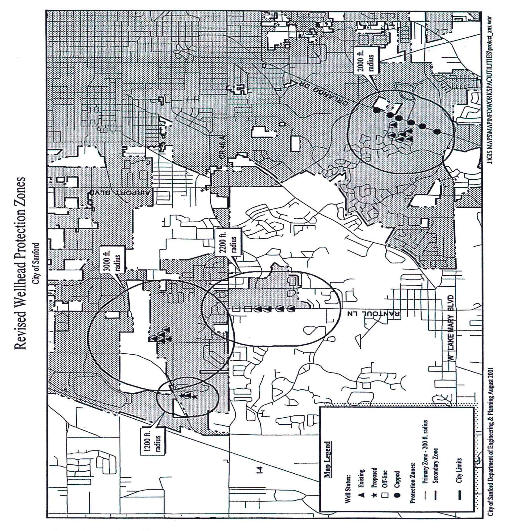
Section 6.0. - Wellfield protection; duties with regard to potentially adverse environmental actions and occurrences.
A.
Purpose and intent. The purpose and intent of this Section is to protect potable water from contamination by establishing primary and secondary protection zones around municipal potable water wells, to prohibit certain land uses and activities within the zones which have the potential to contaminate groundwater and to provide for the duties of persons with regard to potentially adverse environmental actions and occurrences.
B.
Applicability. The land development regulations set forth herein shall apply to all development proposed in areas surrounding a wellfield within primary and secondary protection zones and all actions and events within the jurisdictional limits of the City.
C.
Establishment of wellfield protection zones.
1.
Primary protection zone. Primary protection zones shall include all land within a 200-foot radius of any existing or planned public wellhead (a water system owned by a public entity or operated under a franchise agreement approved by the City).
2.
Secondary protection zone. Secondary protection zones shall include all land within any public wellhead.
D.
Mapping. Wellfield protection zone maps shall be available for review in the department of engineering and planning. Such maps will designate and graphically represent the primary and secondary wellfield protection zones and may be amended from time to time as updated information becomes available.
E.
Restrictions within the zones. Prohibited land uses and activities within the protection zones are as follows:
1.
Primary protection zone. The following land use activities shall be prohibited within the primary protection zone: sanitary landfills, animal feedlots, wastewater treatment facilities, petroleum and pesticide storage facilities, incinerators, and all other activities that store, handle, or generate hazardous materials or wastes. Above-ground or below-ground pipes which store or transfer pollutants or other contaminants as well as open drainage cuts below the seasonal high water table shall also be prohibited within the primary protection zone. All other active uses are prohibited that could be foreseen to result in any environmental degradation to the public water supply.
2.
Secondary protection zone. The following land use activities are prohibited within the secondary protection zone: sanitary landfills, junkyards, solid waste disposal other than brush and stump, animal feedlots, wastewater treatment facilities, petroleum and pesticide storage facilities, incinerators, and all other activities that store, handle, or generate hazardous materials or wastes. Above-ground or below-ground pipes which store or transfer pollutants or other contaminants as well as open drainage cuts below the seasonal high water table are prohibited within the secondary protection zone.
F.
Wellfield protection zone review process. The City shall review all site plans, master plans, and subdivision plans for consistency with the terms and requirements of this section and no application or plan shall be approved unless full compliance is demonstrated. Permits issued in violation of this section confirm no right or privilege on the grantee.
G.
Duties with regard to potentially adverse environmental actions and occurrences.
1.
"Contaminant" means any physical, chemical, biological, or radiological substance present in any medium which may result in adverse effects to human health or the environment or which creates an adverse nuisance, organoleptic or aesthetic condition in groundwater including, but not limited to, solvents and chemicals that resist grease, oil, water, and heat such as, but not limited to, per- and polyfluoroalkyl substances.
2.
"Discharge" means and includes, but is not limited to, any spilling, leaking, seeping, pouring, emitting, emptying or dumping.
3.
"Hazardous substances" means those substances defined as hazardous substances in the Comprehensive Environmental Response, Compensation and Liability Act of 1980, Public Law Number 96-510, 94 Statutes 2767, as amended by the Superfund Amendments and Reauthorization Act of 1986.
4.
"Petroleum product" means any liquid fuel commodity made from petroleum including, but not limited to, all forms of fuel known or sold as diesel fuel, kerosene, all forms of fuel known or sold as gasoline, and fuels containing a mixture of gasoline and other products, excluding liquefied petroleum gas and American Society for Testing and Materials (ASTM) grades no. 5 and no. 6 residual oils, bunker C residual oils, intermediate fuel oils (IFO) used for marine bunkering with a viscosity of 30 and higher, asphalt oils, and petrochemical feedstocks.
5.
"Pollutant" means and includes oil of any kind and in any form, gasoline, pesticides, ammonia, chlorine and derivatives thereof, excluding liquefied petroleum gas, a commodity made from oil or gas including, but not limited to, refined crude oil, crude tops, topped crude, processed crude petroleum, residue from crude petroleum, cracking stock, uncracked fuel oil, fuel oil, treated crude oil, residuum, gas oil, casinghead gasoline, natural gas gasoline, naphtha, distillate, condensate, gasoline, waste oil, kerosene, benzine, wash oil, blended gasoline, lubricating oil, blends or mixtures of oil with one or more liquid products or byproducts derived from oil or gas, and blends or mixtures of two or more liquid products or byproducts derived from oil or gas, whether hereinabove enumerated or not.
6.
It shall be the affirmative duty of each and every person who causes or is aware of a discharge of a contaminant, hazardous substance, petroleum product or pollutant within the City limits upon the ground or in a water body to report such discharge to the City, Seminole County and the Florida Department of Environmental Protection and Florida Department of Health immediately upon the discharge occurring on the person becoming aware of the discharge. It is prohibited and unlawful to fail to report such discharges as required herein and each day of failure shall be a separate violation. This requirement shall not apply to discharges that relate to public utility systems.
(Ord. No. 4748, § 2, 9-11-2023)
Editor's note— Ord. No. 4748, § 2, adopted Sept. 11, 2023, amended the title of Section 6.0 to read as herein set out. The former Section 6.0 title pertained to wellfield protection.
Section 7.0. - Exemptions.
Any applicant may request that required submittal information described in this schedule be omitted from the application in question provided, however, that such request shall be subject to the following requirements:
A.
The request shall be in written form and shall be submitted to the administrative official.
B.
The request shall identify the information, item or data that is proposed to be omitted from the application and shall fully explain the reasons that such information, item or data does not apply to such application.
C.
The administrative official has the authority to accept or reject such request.
Section 8.0. - Land unsuitable for development.
If, in the review of any land use or development located in or on environmentally sensitive lands, it is found that the land proposed to be developed is unsuitable for such development due to frequent flooding, bad drainage, unstable soil, topographic formations, wetland vegetation, sinkholes or other such conditions that may unduly increase the danger of health, life, or property or aggravate erosion or flood hazards; and, if from adequate investigations conducted by the appropriate public official involved, it has been determined that in the best interest of the public the land should not be developed for the purpose proposed, the proposed use or development shall not be approved unless acceptable methods are formulated by the developer for meeting the problems that such development and land use will create. If there is any alleged error in any order, requirement, decision or determination related to the failure to approve a proposed land use or development due to the fact the proposed land area is unsuitable for development, the aggrieved applicant or other interested person, including any officer, department or agency of the city, may make an administrative appeal to the city commission as provided in this schedule.
Section 9.0. - Development of non-navigable lake access property.
A.
Legislative findings and intent. The city commission finds and determines as follows:
1.
The city staff report and city commission agenda memorandum relating to this matter are hereby adopted as if fully set forth herein.
2.
The foregoing recitals (whereas clauses) are hereby adopted as the legislative findings of the city commission and incorporated into this section as if set forth in haec verba.
3.
The city has complied with all requirements and procedures of Florida law in processing and advertising this section.
4.
The city commission desires to encourage the beneficial and lawful reasonable use of non-navigable lakes located within the city while ensuring that natural resources are protected and the protection and advancement of the public health, safety, aesthetics and welfare is honored and occurs and that excessive and unnecessary noise is prohibited as a public nuisance.
5.
The provisions of this section shall not be applied in a manner which conflicts with the provisions of F.S. § 166.033(4), relating to development permits, which provides that the city "… may not require as a condition of processing or issuing a development permit that an applicant obtain a permit or approval from any State or Federal agency unless the agency has issued a final agency action that denies the Federal or State permit before the municipal action on the local development permit."
B.
Non-navigable lake protection and development regulations.
1.
Definitions. The definitions used in the land development regulations of the city and the definitions set forth at F.S. § 327.02 1 , [2] shall be applicable, when the context suggests or demands, relative to the implementation of the provisions of this section.
Non-navigable lake access property means a property, parcel or lot abutting a non-navigable lake and used or intended to be used, for providing access to a non-navigable lake by pedestrian or vehicular traffic to and from offshore land regardless of whether said access to the water is gained by easement, common fee ownership, lease, license, gift, business invitation or any other form or dedication or conveyance.
2.
Land development regulations relating to non-navigable lakes. The following regulations apply to any zoning district/classification where a parcel of land is contiguous to a non-navigable lake, such parcel of land may be used as non-navigable lake access property or as common open space non-navigable lake access property held in common by the property owners of a subdivision, an owners association of whatever type or nature, or any similar entity; or held in common by virtue of the terms of a plat of record; or provided for common use under deed covenants or restrictions of record; or easement, park, common-fee ownership, single-fee ownership, condominium arrangement, license, or lease; or owned by two or more dwelling units located away from the waterfront, but only if the following conditions are met:
a.
A parcel must be a minimum of 7,000 square feet in size and have a minimum of 50 linear feet of lake frontage in such common lake front area, as measured along the normal high water mark line of the lake and a minimum parcel depth of 140 feet or 165 feet if no public sanitary sewer is available.
b.
A non-navigable lake access parcel shall not be permitted if it consists of a wetland, swamp, marsh or bog as shown on the most recent U.S. geological survey maps or any other federal or state data source that is found by the city to be reasonably relied upon for the purpose of making such a determination nor shall the parcel be altered by dredging, the addition of earth or fill material or by the drainage of water frontage to be made non-navigable lake access property; provided, however, that, this section shall not be construed or interpreted to conflict with any federal or state permitting or regulatory program.
c.
No more than four lawfully registered vessels may be stored in any manner on land or in the water on non-navigable lake access property.
d.
The access and use regulations contained in this section shall be fully applicable to all planned development (PD), open space development community and plats or developments unless such additional access use is approved as a conditional use (if authorized in the zoning district involved).
e.
In addition to the above limitations, no easement, private park, common area, lot or access property abutting or adjoining a non-navigable lake shall be used to permit access to the lake for more than two single-family homes, dwelling units, condominiums, apartments or any other use unless such additional access use is approved as conditional use.
C.
Implementing administrative actions; user's manual; adoption of administrative rules. The city manager, or designee, shall have the power and authority, and is encouraged, to adopt a user's manual to assist in the implementation of this section.
D.
Enforcement and penalties.
1.
The provisions of this section may be enforced by the city utilizing any legal remedy or code enforcement process available under controlling state law. Any continuing violations of the terms, conditions, regulations, limitations or provisions of this section may be enjoined and restrained by an injunctive order of the circuit court in appropriate proceedings instituted for such purposes. The city attorney is authorized to file such actions with the concurrence of the city manager may initiate proceedings for the purposes of obtaining an injunction, restraining order, or other appropriate civil proceedings to prevent, enjoin, abate, or remove any violation of this section.
2.
The penalties for violation of this section shall be the maximum authorized penalty under the remedy, process or procedure which the city elects to pursue.
3.
A person violating any of the terms, conditions, regulations, limitations or provisions of this section shall be subject to penalty. Each day that any violation of the terms, conditions, regulations limitations or provisions of this section shall continue to exist, shall constitute a separate and distinct offense. Any continuing violations of the terms, conditions, regulations, limitations or provisions of this section may be enjoined and restrained by an injunctive order of the circuit court in appropriate proceedings instituted for such purposes upon a consensus of the city manager and city attorney to proceed with regard to such matter.
4.
In addition to any and all remedies set forth in controlling, the cost of recovery, and the cost of removal shall become a special assessment on the property upon which is the subject matter of the action.
(Ord. No. 4400, §§ 1—4, 4-24-2017)
For example F.S. § 327.02(43) defined the term "vessel" by stating that the term "… is synonymous with boat as referenced in § 1(b), Art. VII of the State Constitution and includes every description of watercraft, barge, and airboat, other than a seaplane on the water, used or capable of being used as a means of transportation on water."