Sanford City Zoning Code
Schedule N
SUBDIVISION REQUIREMENTS1
Editor's note— Ord. No. 4612, § 1(a)(Exh.), adopted June 28, 2021, amended Schedule N in its entirety to read as herein set out. Former Schedule N, §§ 1.0, 1.1—1.5, 2.0, 2.1, 2.2, 3.0, 3.1, 3.2, 4.0, 4.1, 5.0, 5.1, 5.2, and 6.0—9.0, pertained to similar subject matter, and derived from Ord. No. 4337, § 2, adopted Mar. 23, 2015; and Ord. No. 4432, § 4, adopted Jan. 22, 2018.
Cross reference— Planning and development, ch. 74; streets, sidewalks and other public places, ch. 94.
Section 1.1. - Applicability; general provisions; abbreviations uses.
All subdivisions, streets, lots, tracts and related improvements shall be developed and improved in accordance with the minimum standards and requirements set forth in this Schedule and in accordance with the Manual of Uniform Minimum Standards for Design, Construction and Maintenance for Streets and Highways (commonly known as the "Florida Greenbook"), whichever is more restrictive. Many provisions of the Florida Greenbook are phrased as suggestions ("should") instead of requirements ("shall"). The Administrative Official may require a higher standard and interpret the suggestions of the Florida Greenbook as mandatory requirements, when the application of such as a development requirement is based upon an analysis of the unique aspects of a development being of such a nature that such requirement is necessary to protect the safety of the traveling public and is consistent with the application of sound and generally accepted land use planning practices and principles all of which shall be set forth in a development order issued by the Administrative Official.
When a publication containing standards is referred to herein, the reference is to the latest edition of that publication.
Nonconforming properties or access features shall be brought into compliance with this Schedule to the greatest extent practical when the following conditions or circumstances occur:
•
A new driveway permit is requested;
•
An increase in land use intensity or density is requested;
•
A significant change in trip generation is requested; or
•
As changes in road design allow.
Whenever a determination under this Schedule requires, under Florida law, a determination to be made by the City which would require a determination by a licensed professional engineer, such determination shall be made by the Administrative Official upon consulting with City Engineer or an engineering consultant of the City. The City Engineer or engineering consultant, as the case may be, may rely upon the sealed plans or opinion of a Florida licensed engineer. Such determinations shall be made by means of the issuance of a development order issued by the Administrative Official.
Abbreviation:
Wherever in this Schedule the following terms and abbreviations appear, their intent and meaning shall, unless specifically stated otherwise, be interpreted as follows, and the City Clerk, as Code Codifier, may add and delete abbreviations without action by the City Commission upon recommendation by the Administrative Official:
(Ord. No. 4612, § 1(a)(Exh.), 6-28-2021)
Section 1.2. - General street design and arrangement.
A.
Comprehensive Plan Consistency. Proposed streets must be consistent with the Traffic Circulation Plan Element of the Comprehensive Plan. In addition, proposed streets shall conform to requirements set forth in Schedule C, Base Building Line and Designated Right-of-Way Lines for specific streets.
B.
Natural Contours. Proposed streets shall be adjusted to the contour of the land so as to produce usable lots and streets of reasonable gradient.
C.
Connectivity.
1.
The street system of a proposed subdivision shall be designed to coordinate with existing, proposed, and planned streets outside of the subdivision while discouraging the use of local streets by cut-through traffic. This may be accomplished by the use of modified grid systems, T-intersections, roadway jogs or other appropriate traffic calming measures within the development.
2.
Wherever a proposed development abuts unplatted land or a future development phase of the same development, street stubs shall be provided as deemed necessary by the City to provide access to abutting properties or to logically extend the street system into the surrounding area consistent with sound engineering and planning practices and principles. All street stubs shall be provided with temporary turn-around or cul-de-sacs unless specifically exempted by the City based upon a finding and determination that the public interest does not require such construction which determination shall be memorialized in a development order. Subsequently, the restoration and extension of the street shall be the responsibility of any future developer of the abutting land.
3.
Subcollector and local residential access streets shall connect with surrounding streets to permit the convenient movement of traffic between residential neighborhoods or facilitate emergency access and evacuation.
4.
Whenever local and minor residential street connections between abutting subdivisions are required by the City, the connecting facility shall be designed to discourage through traffic by nonresidents. This may be accomplished by the following when approved by the City:
a.
Curving the street, whenever practicable, to the extent necessary to avoid roadway segments where higher operating speeds can be attained;
b.
The planned design and posted speed for these vehicular linkages between residential subdivisions to be equal or less than 25 miles per hour;
c.
Encouraging the use of traffic circles, landscape islands, medians and other forms of traffic barriers within the right-of-way as a means of discouraging through traffic by nonresidents.
D.
Street Jogs. Street jogs, or centerline offsets in the horizontal alignment of streets across intersections of less than 200' are prohibited.
E.
Street Intersections. The design and location of intersections shall be consistent with the specifications of the Florida Green Book.
Intersections shall be designed to intersect at right angles where possible and in no case shall intersect at an angle less than 60 degrees.
The connection of more than 2 streets is prohibited except where no alternative reasonably exists as determined by the City.
1.
Spacing for Unsignalized Street Intersections.
a.
The minimum spacing requirements of this section may be reduced upon finding by the City that, given the particular conditions of the proposed development, the minimums cannot be met and such reduction will not compromise operational and safety standards.
b.
An arterial road may intersect an arterial road only if aligned with and extending an existing arterial or at a desirable distance of 1 mile from the intersection of existing arterials.
c.
A collector may intersect an arterial but only if aligned with and extending an existing collector which intersects the arterial or at a desirable distance of 1320' from the intersection of an existing collector and the arterial.
d.
Intersections between local streets and arterials shall be avoided. In cases where they do intersect, the local street shall be aligned with and extending an existing local street which intersects the arterial or at a desirable distance of 660' from any other street intersection.
e.
A collector may intersect another collector only if aligned with and extending an existing collector or at a desirable distance of 660' from the intersection of any other intersection.
f.
A local street may intersect a collector if spaced at a minimum distance of 660' from any other intersection or, in the case of a "T" type intersection, at a desirable distance of 660' from any other street intersection.
g.
A residential street functions only to service a local residential community and does not connect any higher classified roadways.
2.
Spacing for Signalized Intersections. It is desirable that intersections that are to be signalized have spacing specifications that are different from that of non-signalized intersections in order that distances between signals be capable of providing reasonable cycle lengths. The need for signals will be based upon one or more of the warrants included in the MUTCD being satisfied. The following are minimum spacing of signalized intersections for both urban and rural roadways:
F.
Half Streets. Half streets are prohibited.
G.
Street Names. All streets within a subdivision hereafter established shall be named. All street names shall be reviewed under current controlling guidelines. All street names shall be subject to approval by the Administrative Official.
H.
Additional Right-of-Way. A proposed use, development or subdivision that abuts an existing street that does not conform to the minimum right-of-way requirements set forth in this Schedule, shall provide for the dedication of additional right-of-way along either one or both sides of said street so that the minimum right-of-way required by these regulations can be established when a rational nexus exists and a rough proportionality test supports the requirement. Additional right-of-way shall be dedicated to the applicable public entity.
I.
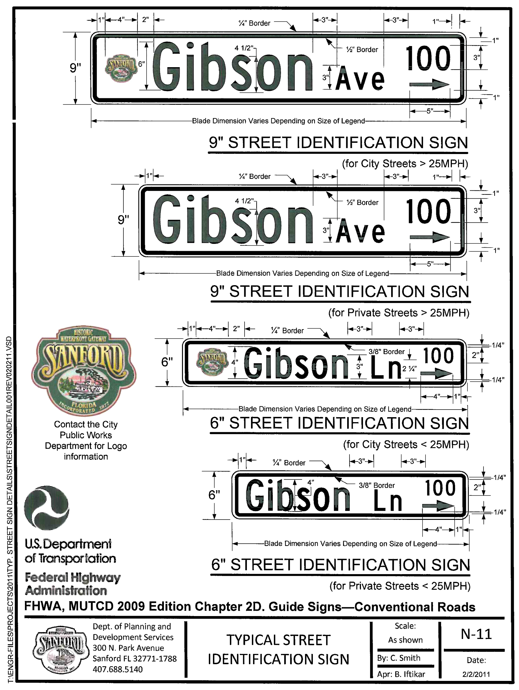
Street Identification Signs. Street identification signs which comply with the following specifications shall be installed by the developer at all street intersections (See Figure N-11).
1.
Sign Design. All street identification signs shall be double sided. Signs shall be constructed of flat panel aluminum (.080 thickness for 6" panels and .063 thickness for 9" panels) with 3/4" rounded corners. Sign panels shall be a minimum of 6" in height for local streets (25 MPH or less) and 9" on all other streets. The length of the sign shall be determined by the legend.
2.
Sign Lettering. Sign legends shall be in the font 'Highway Gothic' or the equivalent as specified in the Standard Highway Signs Manual. Sign legends shall be in capital letters. Signs faces shall have a white high intensity 3M material or equivalent reflective backing with black vinyl legend and border. All sign legends shall incorporate block designation and the City logo. For City streets, the logo shall be placed on the left side and the block designation shall be placed on the right side with equal spacing between border and legend. Private streets shall not use the City logo but shall comply with all other design standards of this subsection.
3.
Posts and Hardware. Posts shall be a standard 2 3/8" diameter by a minimum of 10' high. Posts shall be made of galvanized steel and shall be secured in order to avoid vandalism of the sign.
4.
Post Cap. The post cap shall be a 'Supra-Lok 922F' or equivalent aluminum cap for a 2 3/8" round post or a 91UF-OL90 for a U-channel post.
5.
Cross Separator. The cross separator shall be a 'Supr-Lok9-90F' or equivalent.
6.
The alternative bracket shall be a VS-Twist bracket or equivalent to accommodate 6" blades or 9" blades for mounting above 'stop' signs.
J.
Traffic Speed Enforcement Signs. Traffic speed enforcement signs shall be installed by the developer. The number and location of traffic enforcement signs shall be determined by the Administrative Official.
K.
Reverse Curves. A tangent of at least 100' shall be introduced between reverse curves on all streets.
L.
Horizontal and Vertical Curves. Whenever a street changes direction or connecting street lines deflect from each other by more than 2 degrees horizontal alignment or 1% algebraic difference for vertical alignment, adequate sight distance shall be provided with horizontal and vertical curves with minimum centerline radii as follows:
*If a local street has less than a 100' horizontal radius, the pavement shall be a minimum of 30' in width.
M.
Intersection Return Radii. The minimum intersection radii of pavement edge, or back of curb, where used, at all typical intersections, except for alleys, approximating a right angle shall be as follows: The minimum intersection return radius of pavement edge, or back of curb, where used, at all typical intersections approximating a right angle shall be as follows:
N.
Other Street Improvements. The developer shall be responsible for installing all transportation related improvements required by the City including, but not limited to, auxiliary lanes, traffic control signs, stop signs, stop bars, speed limit signs, street name signs and cross walks. All traffic control devices, including pavement markings, shall conform to the MUTCD. Painted wooden regulatory signs are prohibited. High intensity 30" stop signs shall be used.
When a modification to the width of an existing roadway is necessary, a minimum 1' of asphaltic concrete overlay with leveling will be installed the full width and length of the entire affected section of the adjacent roadway which will maintain drainage flow paths. The overlay shall extend a minimum of 12" beyond the existing width of the pavement.
When more than 15 mailboxes are grouped or clustered together, a temporary off-street parking space shall be provided adjacent to the mailboxes. A sign shall be provided designating the parking space as temporary and for the use of persons accessing the mailboxes.
O.
Clear Zone. The clear zone is the total roadside border area starting at the edge of the motor vehicle travel lane, available for safe use by errant vehicles. It is usually the space between the travel lane and the sidewalk. Clear zone shall be provided in accordance with the Florida Green Book. No obstructions, except breakaway items, as defined by FDOT standards, shall be permitted in the clear zone.
P.
Street Trees. Street trees will be permitted only upon approval of the Administrative Official. Additional right of way may be needed in order to locate the street trees out of the clear zone and away from public utilities.
Q.
Design Speed. All new streets shall be designed according to the expected rate of travel by the 90th percentile user, plus a minimum of 5 MPH. The stated design speed shall be shown on the construction plans for the streets. The Administrative Official may require an increased design speed, when it is in the interest of public health, safety, and welfare and is consistent with sound and generally accepted engineering practices and principles.
(Ord. No. 4612, § 1(a)(Exh.), 6-28-2021)
Section 1.3. - Local streets.
A.
Local Street Types. When a street's right-of-way is not established in Schedule C of these Land Development Regulations, such street shall be classified as a local street. Major local streets that serve to collect and distribute traffic from shorter local streets within a parcel of twenty or more acres in size shall be designated and identified as local collector streets.
B.
Minimum Right-of-Way and Pavement. Pavement width shall be exclusive of curb and gutter. Each travel lane shall have a minimum pavement width of 12', except for alleys. The minimum right-of-way width and pavement width for urban local streets shall be as follows:
Urban Local Streets
C.
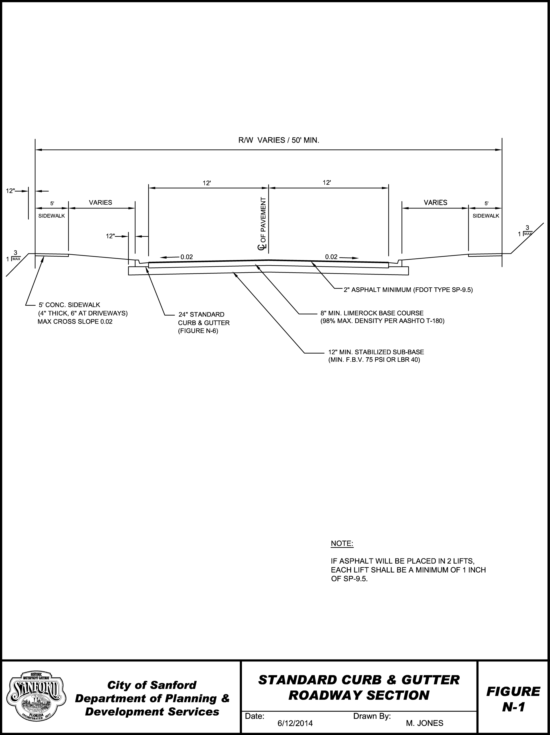
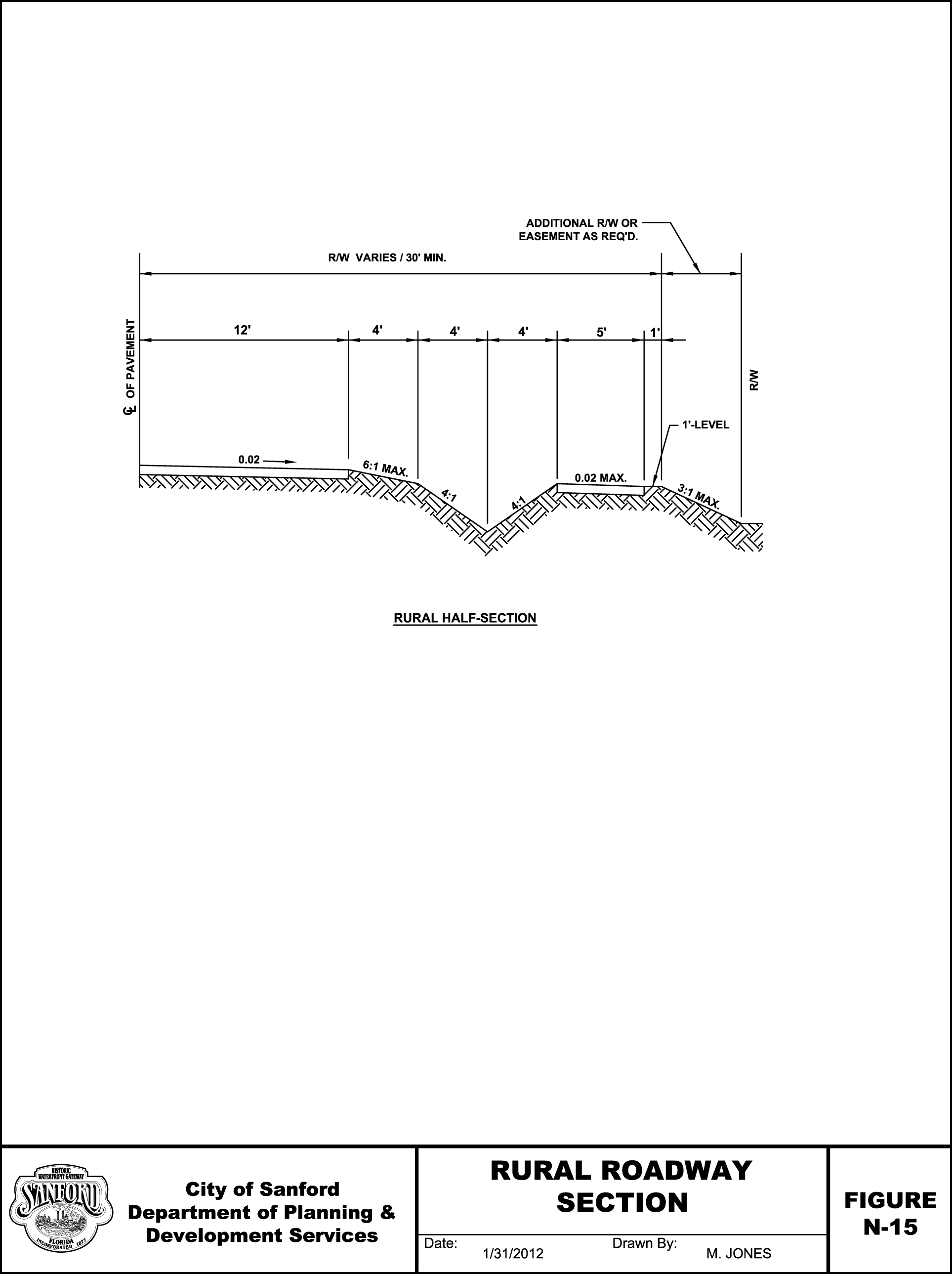
Urban and Rural Streets. Streets in the City shall utilize urban-type design features with a "closed" drainage system including gutters, inlets and Miami or raised curbs. New rural-type street design features with an "open" drainage system including open swales are prohibited. Typical details of urban street sections are reflected in Figure N-1. Local streets shall not be superelevated, but shall utilize a standard crown. Alleys may use an inverted crown.
D.
Permanent Dead-End Streets. Dead-end streets designed as such permanently, shall be provided with a cul-de-sac at the closed end with a turnaround having an outside roadway diameter of not less than 100', and a right-of-way diameter of not less than 110'. Such dead-end streets shall not exceed 800' from cul-de-sac radius to centerline intersection of the closest intersecting street. The Administrative Official may increase the length, based upon sound and generally accepted engineering practices and principles.
1.
Cul-de-sac. Cul-de-sacs shall be provided with a turnaround having a pavement radius of 50' excluding the curbing. If an island is to be constructed in the cul-de-sac, the minimum turnaround radius shall be 50' and shall be measured from the outside radius of the island. The island shall have FDOT mountable curbs and a minimum diameter of 20'. The island shall be improved with landscaping that will not interfere with the clear sight distance.
2.
Temporary Dead-End Streets for Future Access. Temporary dead-end streets shall be provided with a temporary turnaround area which shall meet the requirements of the Administrative Official for design, maintenance, and removal. An easement for roadway maintenance, in a form approved by the City Attorney, shall be dedicated around the turnaround which corresponds to the right-of-way requirement for that permanent type of turnaround.
E.
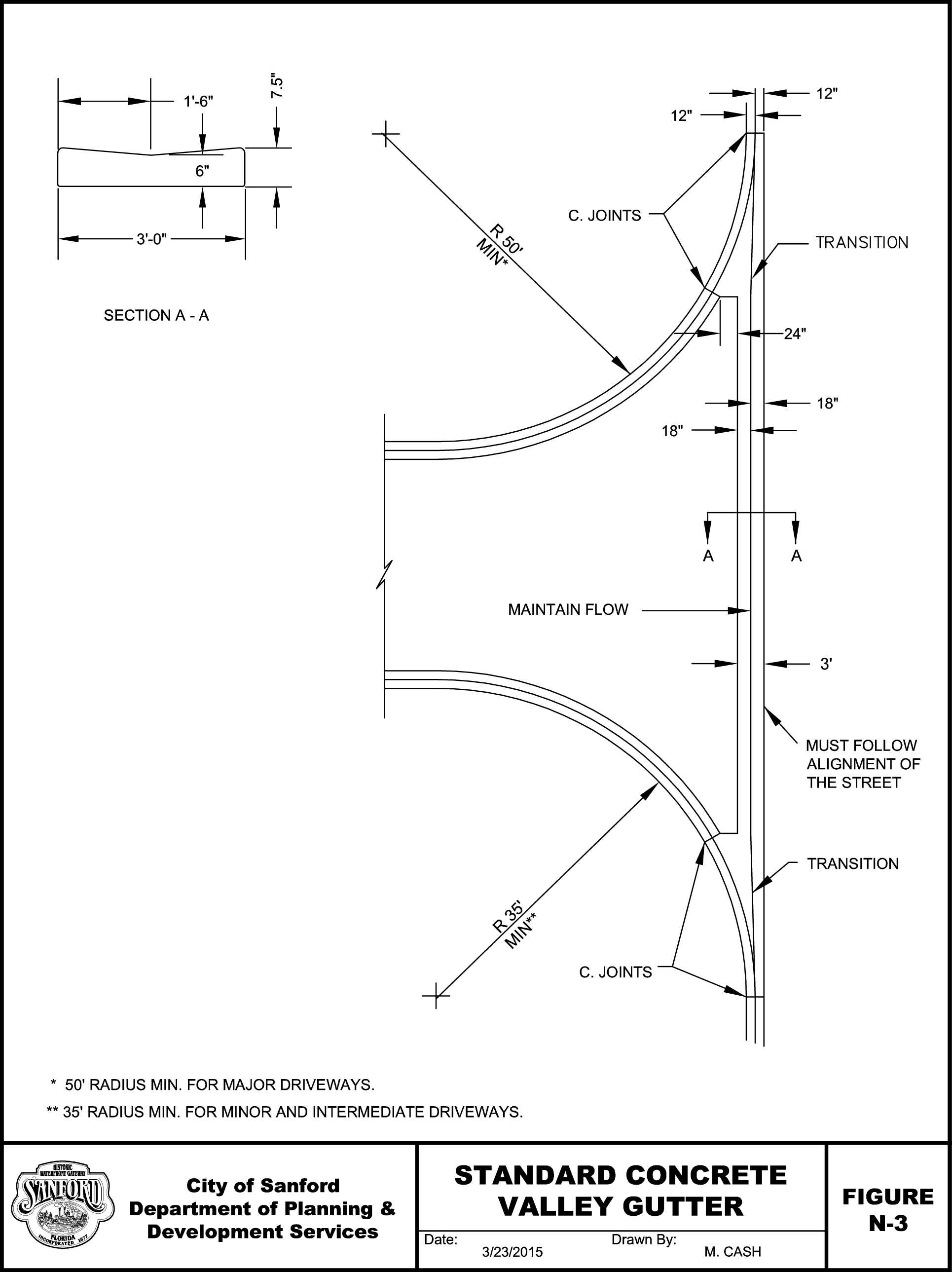
Intersection Improvements. Street improvement at intersections shall include the use of a concrete valley gutter in conformity with specifications illustrated on Figure N-3, unless the applicant can demonstrate that there will be no drainage flow across the driveway from adjacent gutters.
F.
Traffic Calming Program. Traffic calming is the combination of mainly physical measures that reduce the negative effects of motor vehicle use, alter driver behavior and improve conditions for nonmotorized street users.
Traffic Calming Criteria:
1.
Roadway must have a documented issue with speeding (observed 85 th percentile speed is greater than 10 MPH over posted speed limit).
2.
Minimum/Maximum Roadway Volume: 750 vehicles per day/5,000 vehicles per day (to be determined through existing annual counts, if available, or a new count).
3.
Maximum Speed: The posted speed on the roadway must not exceed 30 MPH.
4.
Homeowner approval for installation (and removal): 65%.
5.
Consider other owners impacted by devices (side streets) on a case by case basis.
6.
Functional spacing of devices (primarily for speed cushions or humps):
A.
300'—400' between devices.
B.
Not on curves/turns.
C.
Minimum of 100' from intersections or curves/turns.
D.
Spacing subject to adjustment for driveways.
7.
Roadway must have driveways that directly access the road.
8.
Roadway must be subject to through traffic - not in a "closed development".
9.
Roadway must not be a principal arterial; minor arterial or major collector roadway must be a local street or minor collector (evaluated on a case by case basis).
10.
Roadway character/location (rural vs. urban) - considered on a case by case basis.
The following measures may be approved by the City:
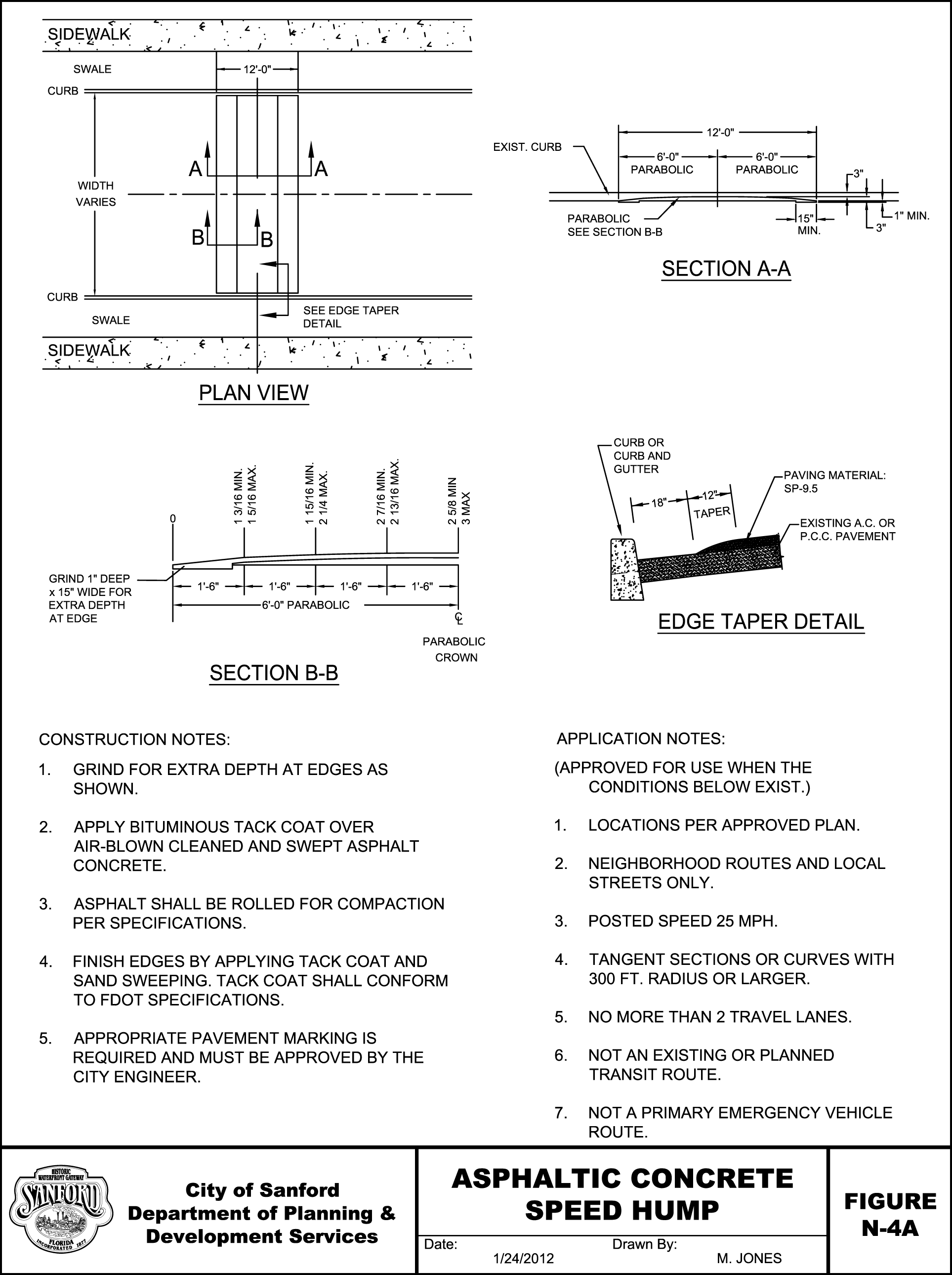
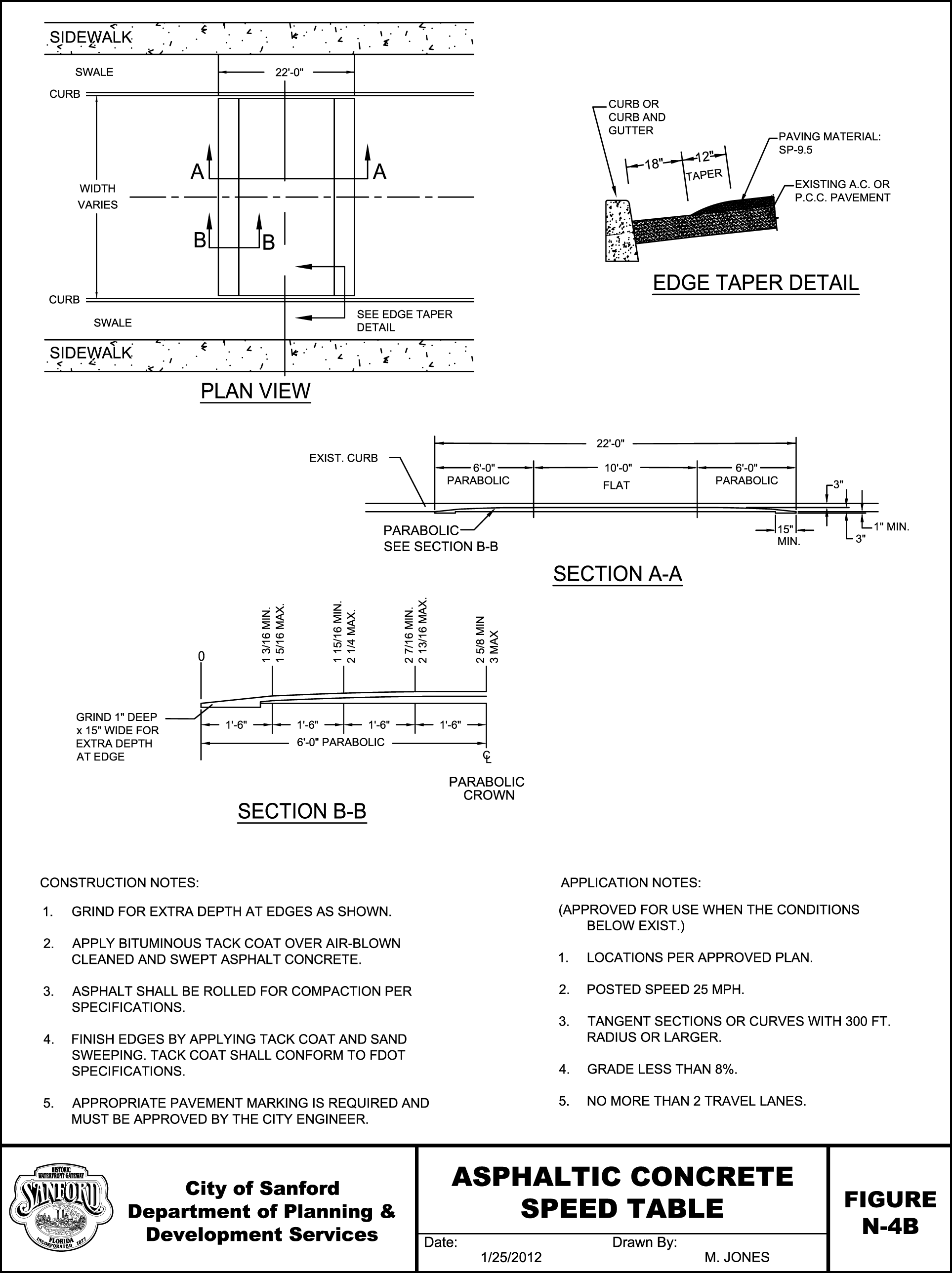
1.
Speed humps and speed tables. Speed humps and speed tables may be used where the purpose is to reduce speed and calm traffic provided they comply with the following (see Figures N-4a and N-4b):
a.
Speed humps shall be parabolic, curved or sinusoidal in profile, 3"—4" high and 12'—14' long. They shall be used to reduce speeds to no more than 15—20 MPH.
b.
Speed tables shall be flat-topped speed humps, also 3"—4" high, but with a sloped approach taper on each side of a flat top, generally 20'—24' wide. They shall be used to reduce speeds to no more than 20—25 MPH.
c.
Speed tables and humps shall be clearly marked with 8" white thermoplastic across the raised area and motorists have 50' of warning before each speed hump or table by signage either painted on the road or on a post adjacent to the roadway.
2.
Speed Bumps. Speed bumps shall not be used on public or private roadways in Sanford. Speed bumps are severe treatments 3"—6" high and 1—2 feet wide that slow drivers to speeds of less than 10 MPH. Due to their abrupt rise and required low speed they can be a hazard to motorists and bicyclists.
(Ord. No. 4612, § 1(a)(Exh.), 6-28-2021)
Section 1.4. - General lot and block design requirements.
A.
Area and Dimensional Requirements. All lots shall comply with applicable area and dimension requirements set forth in Schedules C, D, E, F and J of these Land Development Regulations.
B.
One and Two-Family Dwelling Lots. No lot or tract to be utilized for a one- or two-family dwelling located in a subdivision proposed or platted after December 12, 1988 shall have a vehicular access point to a street classified as an arterial or collector in the Traffic Circulation Element of the Comprehensive Plan.
C.
Multiple-Family Dwelling and Nonresidential Use Lots. Lots and tracts for multiple family dwellings or nonresidential uses that are created after December 12, 1988 shall have a minimum of 200' of linear frontage on an arterial or collector roadway in order to obtain direct vehicular access to such l road. Lots and tracts with less than 200' of linear frontage on an arterial or collector roadway shall only have vehicular access to such arterial roadway through a system of common or shared vehicular access points whereby the minimum spacing between vehicular access points on an arterial is 200'. Such system of common or shared vehicular access points shall be subject to preliminary subdivision plan review procedures set forth in these Land Development Regulations.
D.
Lot Lines. Side lot lines shall be, as nearly as practical, at right angles to straight street lines and radial to curved street lines.
E.
Corner Lots. Corner lots for residential use shall be provided with sufficient width and depth to permit the establishment of appropriate building setback lines from both streets.
F.
Double Frontage Lots. When it is necessary to design a residential subdivision that abuts an arterial or collector, it shall be designed to provide the through-lots along the arterial or collector with access from a frontage road or interior local road. Access rights of these lots to the arterial or collector shall be dedicated to the governmental entity having jurisdiction over the road and recorded with the deed. A decorative wall shall be required at the rear of through lots to buffer residences from traffic on the arterial or collector. The wall shall not be located within the public right-of-way.
G.
Residential Adjacent to Railroads. Where a proposed subdivision contains or is adjacent to a railroad right-of-way, it shall be planned so as to avoid having residential lots front on a street which runs parallel and adjacent to railroad right-of-way.
H.
Block Length. The maximum block length shall be 1,200'.
I.
Water Access. In general, canals and waterways for the purpose of providing access by water to lots within a subdivision shall be prohibited.
J.
Flag Lot Standards.
1.
A flag lot is any lot which does not meet the minimum lot width for the corresponding zoning district at the front property line. Flag lots are prohibited when their effect would be to increase the number of properties requiring direct and individual access connections to any arterial or collector road.
2.
Flag lots may be permitted for residential development, when it is found by the Administrative Official that they are necessary to achieve planning objectives, such as reducing direct access to thoroughfares, providing internal platted lots with access to a residential street, or preserving natural or historic resources, under the following conditions:
a.
Flag lot driveways shall be separated by at least twice the minimum frontage requirement of that zoning district.
b.
The flag lot shall have a minimum frontage width of 20'.
c.
In no instance, shall flag lots constitute more than 10% of the total number of building sites in a recorded plat or 3 lots, whichever is greater.
d.
The lot area occupied by the flag driveway shall not be counted as part of the required minimum lot area of that zoning district.
e.
No more than one flag lot shall be permitted per private right-of-way or access easement.
K.
Lot Width-to-Depth Ratio. To provide for proper site design and prevent the creation of irregularly shaped parcels, the depth of any lot or parcel shall not exceed 3 times its width.
L.
Fire Hydrant Placement. The developer shall install a fire hydrant at the first buildable lot on the side of the inbound lane. In single-family residential developments, there shall be a fire hydrant, thereafter, every 800'. In multi-family residential developments there shall be, thereafter, a fire hydrant every 600'. In commercial and industrial developments there shall be, thereafter, a fire hydrant every 500'.
M.
Fill. All fill material required to bring the natural grade up to the specified lot grade line shall be suitable material, with a maximum of 10% passing a #200 sieve, that is free of trash, wood, roots, used concrete or other matter or material that would later be a detriment to the stability of a building structure, prevent sufficient compaction or artificially raise the water table. The fill shall be placed in successive layers of not more than 12" inches and each layer shall be compacted to a density as to prevent the later deterioration or settling. A geotechnical engineer shall certify, under seal, that any fill placement over 12" above natural grade meets this requirement.
(Ord. No. 4612, § 1(a)(Exh.), 6-28-2021)
Section 1.5. - Private streets and gated communities.
A.
Private streets and roads may be permitted in accordance with the requirements of this Section and the following general standards shall apply:
1.
All private roads shall be constructed to public-road specifications and have an easement of a minimum of 50' in width.
2.
Private roads shall have all traffic control features, such as signage, striping or markers, in conformance with the MUTCD.
3.
The minimum distance between private road outlets on a single side of a public road shall be 660', or less where provided by access classification and standards for State roads and local thoroughfares.
4.
All properties served by the private road shall provide adequate access for emergency vehicles and shall conform to the approved local street numbering system.
5.
All private roads shall be designated as such and will be required to have adequate signage indicating the road is a private road and not publicly maintained.
6.
All private roads shall have a posted speed limit not to exceed 25 MPH.
7.
All private roads shall have adequate provisions for drainage and stormwater runoff as provided in Schedule O of these Land Development Regulations.
8.
A second access connection to a public road shall be required for private roads greater than 2000' in length.
B.
Applications for subdivision approval that include private roads shall include a drainage plan and road construction plan, prepared, under seal, by a Florida licensed engineer. The Administrative Official shall review private road plans for conformance with this Schedule.
C.
Construction permits are required for connection to public roads. Application for road construction shall be made concurrent with the creation of a lot that does not have frontage on a public road. A road construction permit shall be issued after approval of the private road plan and the entire length of the road shall be inspected during construction and upon completion. If found in conformance, a final use permit shall be issued.
D.
No building permit will be issued for any lot served by a private road until the private road has been constructed and approved, so that all lots to be served by the private road have access to a public road. A road maintenance agreement, subject to approval by the City Attorney, shall be recorded with the deed of each property to be served by a common private road. The agreement shall provide, at a minimum, for:
1.
A method to initiate and finance a private road and maintain that road in good condition;
2.
A method of apportioning maintenance costs to current and future users;
3.
A provision that the City may inspect, and if necessary, require that repairs be made to the private road to ensure that safe access is maintained for emergency vehicles. If required repairs are not made within 60 days of date of notice, the City may make the necessary repairs and assess owners of parcels on the road for the cost of all improvements plus an administrative fee of 25% of total costs for management and other services;
4.
A provision that the majority vote of all property owners on the road shall determine how the road is maintained except in the case of emergency repairs as outlined above;
5.
A statement that no public funds shall be used to construct repair or maintain the road;
6.
A provision requiring mandatory upgrading of the roadway if additional parcels are added to reach the specified thresholds; and
7.
A provision that property owners owning property located along the road are prohibited from restricting or in any manner interfering with normal ingress and egress by any other owners or persons needing to access properties with frontage on that road.
E.
No private road shall be considered for incorporation into the public road system unless it is built to public road specifications of the City and in good condition at the time of the request. The property owners shall be responsible for bringing the road into conformance.
Roadways constructed in conjunction with multifamily or townhouse developments shall not become a part of the public road system of the City whether or not they conform to the City's public roadway specifications.
F.
An application fee will be established by the Administrative Official to cover administrative, processing, and inspection costs.
G.
All purchasers of property served by a private road shall, prior to final sale, be notified that the property receives access from a private road that shall be maintained collectively by all property owners along that road; that the City shall not be held responsible for maintaining or improving the private road; and that a right-of-way easement to provide the only access to that property has been recorded in the deed for that property.
H.
The United States Postal Service and the Seminole County School District are not required to use the private road for access to the parcels abutting the private road and may require that service be provided only at the closest public access point.
I.
Entryway gates must be a minimum of 20' wide and equipped with an audio (siren) override device to allow emergency access to the subdivision by fire/rescue, police and other emergency-response personnel. The audio-override device must be submitted to the fire and rescue department for inspection and the entrance gates may not be closed unless and until the City determines that the device is acceptable and in good working order.
J.
Automatic gates shall have battery back up power.
K.
The entryway gate must include a box, labeled "City of Sanford," with a master-keyed padlock, and the box must contain a key, a card-key, a code, a remote-control device, or some other means by which mosquito control, animal control, code enforcement, environmental protection and utility workers may gain access to the subdivision. The means of access is subject to approval by the City and the box must be installed prior to the City's issuance of the certificate of completion for the subdivision infrastructure. If a keypad is used, there shall be a 4 digit code set aside for the Sanford fire department. The code shall be determined by the fire department. A 'Knox' box to override gate access is also required as a back-up system. Any other utilities serving the subdivision must have similar access, and the names of such utilities must be on the outside of the box containing the means of access.
(Ord. No. 4612, § 1(a)(Exh.), 6-28-2021)
Section 2.1. - General sidewalk requirements.
Sidewalks shall provide improved surface to serve nonvehicular circulation such as pedestrians and, unless otherwise prescribed by City ordinance, bicycles. Sidewalks shall be designed to be as physically separated from vehicular use areas as possible.
A.
Required Provision. Sidewalks shall be provided on each side of all streets unless it is determined not to be practical by the Administrative Official, based upon sound and generally accepted engineering practices and principles which decision shall be implemented by means of a development order. When it is determined that a sidewalk is not practical in a particular location, the cost for the sidewalk shall be placed into the City's sidewalk fund. The sidewalk fund within the City's financial management structure shall be maintained and administered by the City in accordance with sound and generally accepted public fiscal practices and principles and into which funds shall be deposited and from which funds may be withdrawn pursuant to this Ordinance in order to facilitate the construction of public sidewalks. Subfunds may be created for each area in which sidewalks are to be constructs. Funds may be used for purposes only which benefit the real property for which payment has been made is located. Authorized uses for funds deposited within the sidewalk fund include, but are not limited to, the following activities:
1.
To acquire the fee simple or other interest in land, and other real property for sidewalk purposes.
2.
To coordinate plans for sidewalk improvements and expansion with public transportation plans and operations in the area of the real property for which payment has been made.
3.
To perform such other related activities as may be appropriate to carry out the intent of this Ordinance including, but not limited to, reimbursement of administrative costs, infrastructure improvements in the public right-of-way, and contributing to maintenance of the public sidewalks.
B.
Location. In general, sidewalks shall be located in street right-of-way between the back of curb and the property line.
C.
Width. The minimum width of sidewalks shall be 5'.
D.
Pedestrian Easements. Pedestrian easements, not less than 10' wide, may be required where deemed essential to provide circulation, or access to schools, playgrounds, shopping centers, transportation, and other community facilities. When utilized, pedestrian easements shall include sidewalks. In addition, pedestrian easements may be utilized as an alternative location for sidewalks located in rights-of-way if approved by the Administrative Official and provided that minimum right-of-way requirements are provided. Such easements shall be in a form approved by the City Attorney.
(Ord. No. 4612, § 1(a)(Exh.), 6-28-2021)
Section 2.2. - Sidewalk construction requirements.
A.
Sidewalk. Sidewalks shall be constructed of portland cement concrete with a minimum strength of 3,000 PSI and a minimum thickness of 4" except at vehicular access points or driveways in which case sidewalks shall be a minimum of 6" thick.
B.
Sidewalk Subgrade. Excavation shall be made to the required depth and the subgrade or base upon which the sidewalk is to be set shall be compacted to a firm, even surface, true to grade and cross section, by means of watering, rolling or tamping. The subgrade shall be compacted to a minimum of 95% of the modified proctor (ASTM D-1557) maximum density and a minimum LBR of 40 and shall be moist at the time the concrete is placed.
C.
Expansion Joints. Transverse expansion joints shall be constructed at intervals of 30'. Slabs shall be separated by traverse premolded expansion joint filler 1/4" thick for the full width of the slab, extending from the bottom of the slab to 1/4" of its top surface.
1.
The slab between expansion joints shall be divided into sections 5' in length by transverse contraction joints formed by a jointing tool. Contraction joints shall be a minimum of one and 1 ½" deep. Where slabs are more than 7' in width, control joints shall be formed longitudinally to secure uniform blocks approximately square.
The contractor may use open type or sawed contraction joints:
a.
Open-type Joints: Form open type contraction joints by staking a metal bulkhead in place and depositing the concrete on both sides. After the concrete has set sufficiently to preserve the width and shape of the joint, remove the bulkhead. After finishing the sidewalk over the joint, edge the slot with a tool having a ½" radius.
b.
Sawed Joints: If electing to saw the contraction joints, cut a slot approximately 3/16" wide an not less than ½" deep with a concrete saw after the concrete has set, and within the following periods of time: joints at not more than 20' intervals: within 12 hours after finishing; remaining joints: within 96 hours after finishing.
2.
Expansion joints shall be formed around all appurtenances such as manholes, utility poles, etc., extending into and through the sidewalks. Premolded expansion joint filler 1/4" thick shall be installed at these joints.
D.
Finishing. Provide the concrete with a broom finish. Ensure that the surface variations are not more than ¼" under a 10' straightedge, or more than 1/8" on a 5' transverse section. Finish the edge of the sidewalk with an edging tool having a radius of ½".
E.
Curb Ramps and Detectable Warning Surfaces. Detectable warnings are intended to warn people with visual disabilities using a curb ramp before they enter the path of motor vehicles on the street or alleys (not at driveways) and before crossing railroad tracks.
1.
Applicability. Curb ramps conforming to ADAAG shall be installed when an alteration to a street or sidewalk occurs or when a new sidewalk is constructed. Ramps will be installed or upgraded at all legal crossings within the limits of grind and pave contracts. Existing ramps will be removed and new ramps constructed where the existing ramp:
a.
Does not currently conform to the ADAAG but it is technically feasible to conform; or
b.
Surfaces are brick pavers; or
c.
Existing concrete is not sound.
2.
Plan Requirements. All new construction shall be designed on plan drawings to verify that a design conforms to the ADAAG. This requires a working drawing that shows existing and proposed curbs, pavement markings, traffic control signs, traffic signals, elevations (gutter, top of curb, ramp and sidewalk), dimensions, R/W lines, trees, street furniture, inlets, parking meters and utility covers. The City reserves the right to request this information (drawn at 1"= 10') be submitted prior to approval of construction drawings and permits. Alterations are typically designed in the field and do not include design drawings to verify that ADAAG requirements are satisfied. It is the responsibility of the contractor and field engineer to verify that the "most useable" solution is constructed.
3.
Contrast. In addition to the ADAAG requirements for contrasting colored surfaces, safety yellow is shall not be the contrasting color due to aesthetic reasons. In addition, since dogs perceive black as a hole and walk around black pavement, black is not an acceptable color for detectable warning surfaces. The surface will be red or brick-red in color.
4.
Types of Detectable Warning Surfaces to be Installed:
Detectable Warning, Type B - Detectable warnings in new ramp construction will consist of pre-cast clay or ceramic paving bricks on a 1¼" sand bed on a 5" concrete base. 3½" high forms (nominal 2x4 lumber) are used to create a tub for the bricks to sit in.
Existing concrete ramps shall be reconstructed and surface applied or cast in place mat shall be installed.
(Ord. No. 4612, § 1(a)(Exh.), 6-28-2021)
Section 3.1. - Easements.
The Administrative Official may require utility easements when a rational nexus exists and a rough proportionality test supports the requirement, in a form approved by the City Attorney, for all uses when such an easement is necessary to implement and further the City's public facility master plans. Such easements shall:
A.
Be identified and dedicated on the face of site plans, preliminary subdivision plans and final plats.
B.
Be a minimum width necessary to accommodate the public facility in question.
C.
At a minimum, provide a 10' front property line easement.
(Ord. No. 4612, § 1(a)(Exh.), 6-28-2021)
Section 3.2. - Other utilities.
A.
Electric Supply System. In every subdivision, provision shall be made for a satisfactory electric supply system through the cooperation of the appropriate supplier. The owner or developer of any subdivision shall be required to provide underground wiring for electrical service.
B.
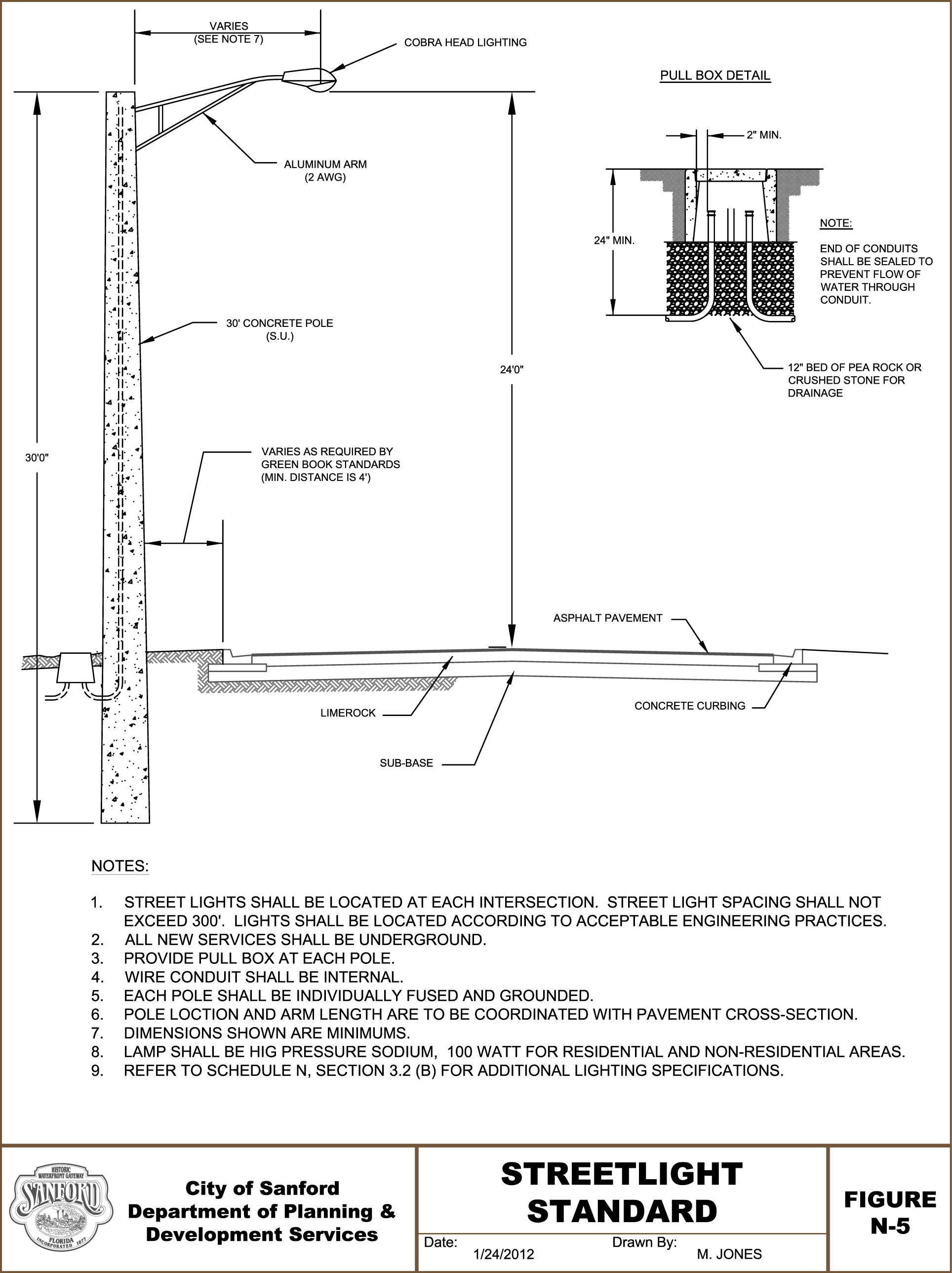
Street Lights. All proposed developments shall provide adequate street lighting using LED fixtures operating in the spectrum between 3000K and 4000K and conforming to the following specifications:
1.
Street lighting design shall be consistent with AASHTO GL-6 and the Federal Highway Association Lighting Handbook, latest edition.
2.
Street Light Standard- Street lights shall conform to specifications illustrated on Figure N-5. The use of decorative light poles and fixtures is encouraged.
3.
Minimum distance from the face of pole to edge of roadway or face of curb shall be 4' for an urban roadway and 6' for an existing rural roadway. Maximum distance shall be established by the City.
4.
The developer or property-owner's association shall be responsible for the maintenance and usage costs of the street lights including, but not limited to, those located within public right-of-way with the binding obligation being memorialized in a document approved by the City Attorney which runs with the land.
C.
Telephone & Cablevision Supply System. In every subdivision, provisions shall be made for a functioning telephone communications supply system and television cable system with the cooperation of the appropriate supplier. In all cases, all wiring shall be placed underground, rather than on poles or towers.
(Ord. No. 4612, § 1(a)(Exh.), 6-28-2021)
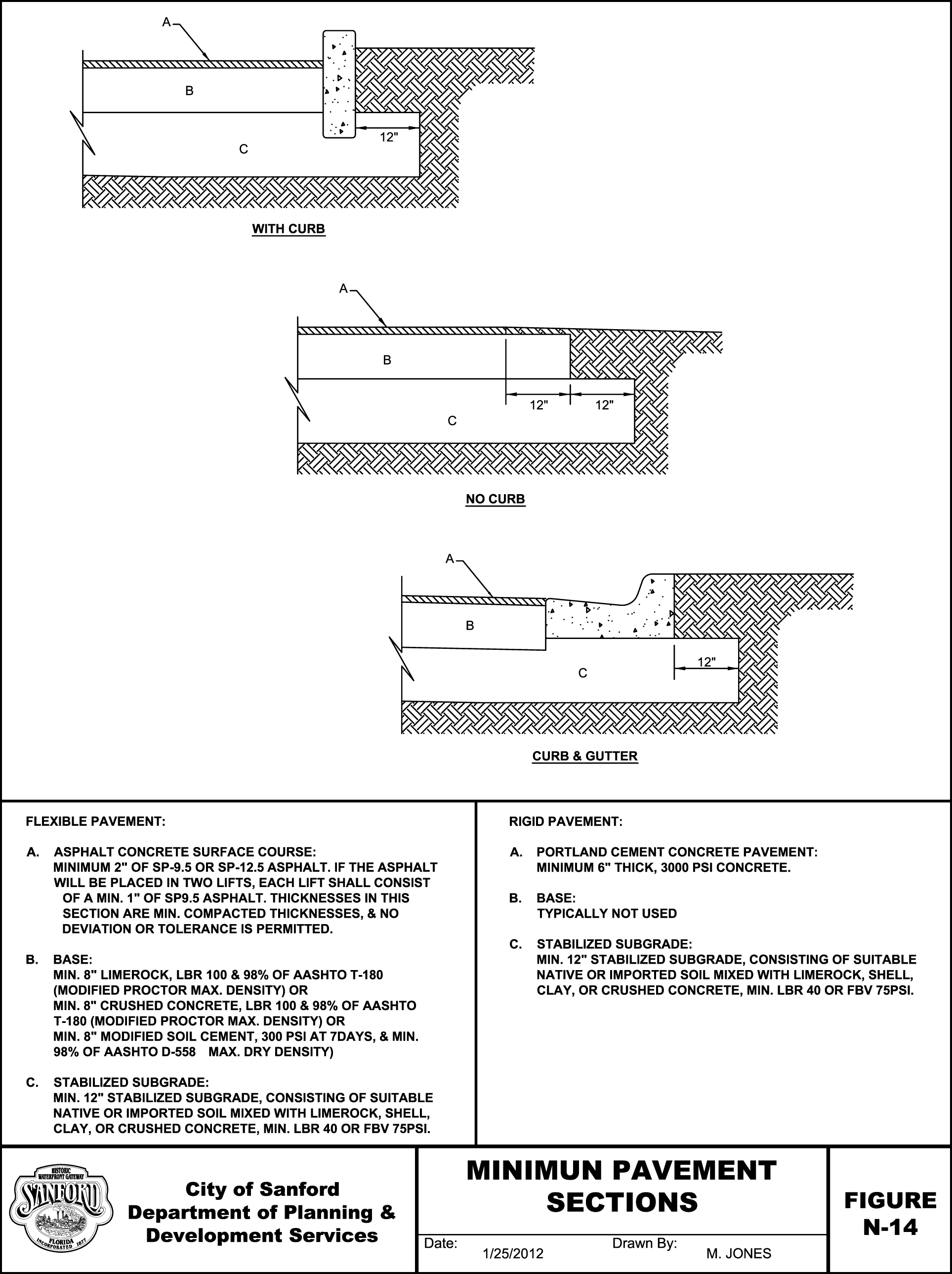
Section 4.0. - Street construction.
All street cross sections, engineering plans and improvement plans shall meet the minimum requirements as set forth in these regulations. Street construction shall conform to the following requirements:
A.
Grades. Minimum street grade shall be 0.30% for roads with standard (Type F) curb and gutter and 0.50% for roads with Miami curb and gutter or other treatment; maximum street grade shall be 8.0%.
B.
General Clearing and Excavation Requirements. All rights-of-way shall be selectively cleared and grubbed for their entire width according to current FDOT specifications. Such activities shall avoid damage to natural vegetation to be preserved on the site. Excavations and depressions must be properly backfilled and compacted. Gumbo and other plastic clays shall be removed within the area one foot below the subgrade and extending horizontally beyond the edge of curb. Muck and peat shall be completely removed within the right-of-way. Trash, brush, trees, etc., may be burned within the right-of-way in a lawful manner and as approved by the Administrative Official.
C.
Fill. All fill material required to bring the grade up to the specified profile grade line shall be suitable material, with a maximum of 12% passing a #200 sieve, that is free of trash, wood, roots, used concrete or other matter or material that would later be a detriment to the stability of the roadbed or prevent sufficient compaction. The fill shall be placed in successive layers of not more than 6" for the full width of the cross section and each layer shall be compacted to a density as to prevent the later deterioration, settling or failure of the pavement. No subgrade is to be covered where the density is found to be less than 98% of the modified proctor maximum density as determined by AASHTO T-180. A geotechnical engineer shall certify, under seal, that the fill meets this requirement prior to placement of the subbase.
D.
Subbase. Subbase means that portion of the roadbed immediately below the base course, the limits of which customarily include those portions of the roadbed shown in the plans to be constructed to a specific bearing value. Unless otherwise approved by the Administrative Official, the subgrade section shall be considered to extend to 12" below the bottom of the base and 12" beyond the base on each side. Subgrade shall extend 12" beyond the back of the curb and gutter. This work shall consist of bringing the bottom of excavations and/or top of embankments of the roadway, between the outer limits of the paving or base course, to a surface conforming to the grades, lines and cross sections shown on approved plans, of uniform density and stability ready to receive the base course.
In no case shall any sub-base be covered that does not have a of 40 or greater or a Florida Bearing Value of 75 PSI.
1.
Care of Subgrade. In order to preserve the integrity, density and compaction of the subgrade, vehicles shall not be permitted on the finished subgrade.
2.
Timing of Subgrade Stabilization. No area shall be stabilized or compacted until all the utilities within that area have been installed. All underground utilities shall be in place before sub-base is stabilized. At no time shall any base material or pavement be laid before the utilities are in place.
3.
Density Requirement for Subgrade. All subgrades shall be compacted to a density of at least 98% of the maximum density as determined by AASHTO T-180 prior to placement of concrete.
E.
Base.
1.
Nonresidential Areas. Base for streets serving nonresidential uses shall be lime rock, soil cement or an equivalent material for which test data and design criteria have been approved by the Administrative Official. The minimum acceptable thickness of either material required in these areas shall be 10" inches. If the base is cut, it shall be replaced with 12" of required material with densities taken on each lift, not to exceed 6" per lift.
2.
Residential Areas. Base for streets serving residential uses shall be lime rock, soil cement or an equivalent material for which test data and design criteria have been approved by the Administrative Official. The minimum acceptable thickness of either material required in these areas shall be 8". If the base is cut, it shall be replaced with 12" of required material with densities taken on each lift, not to exceed 6" per lift.
3.
Performance. Regardless of type or area served, base material shall be compacted to a density of no less than 985 of maximum density as determined by AASHTO T-180.
4.
Width. All bases shall be 1' wider (extended for a distance of 1' on each side) than the outer edge of the improved surface (curb).
5.
Forms. No form boards will be required unless, in the determination of the Administrative Official, based upon sound and generally accepted construction practices and principles, the contractor is not taking precautions to obtain the full depth at the edges.
6.
Prime Coat. Appropriate prime coat and sand shall be applied to all base courses 24 hours prior to paving. The spread rate of the prime coat will be a minimum of 1% and the sand will be rolled in with traffic roller.
7.
Water Table. The seasonal high ground water level shall be a minimum of 1' below the bottom of the base of the road.
8.
Underdrains. Underdrains may be required in areas with poorly drained soils or areas with known high groundwater level conditions or as determined by the Administrative Official. Roads constructed with underdrains to control the water table shall be private and not subject to City maintenance.
F.
Pavement Types and Thickness. Surface courses shall be a minimum of 2" thick and comprised of SP12.5 or S-I compacted asphaltic concrete. The developer shall install a minimum of one (1) inch of SP9.5 or SIII asphaltic concrete prior to the construction of the development. After the last unit is constructed or upon direction of the Administrative Official, the developer will remove the asphalt and install 2" of SP12.5 or S-1 asphaltic concrete. The developer is responsible for maintenance of the roadway and stormwater drainage during this time frame. A performance bond in the amount of 110% of the cost of installing the 2' of SP12.5 asphaltic concrete must be provided in a form acceptable to the City. In cases where there will be no significant loading/unloading, turning of construction vehicles or use of cranes or other damaging construction equipment, the Administrative Official may approve a single lift of 2" of SP9.5, SP12.5. S1 or SIII. Upon completion of the 2" paving the developer shall provide a maintenance bond for the roadway for 3 years at 20% of the certified cost of construction in a form acceptable to the City.
The Administrative Official may approve, disapprove or approve with conditions the use of alternative surface types including but not limited to pervious concrete or impervious portland cement concrete. Alternative surface types shall require design and specifications certified by a licensed professional engineer.
G.
Open Road Cuts. If open road cutting is approved by the Administrative Official, the open cut repair base shall be 8" of Reclaimed Asphalt Pavement (RAP), placed in two 4" lifts and meeting the requirements of Section 283 of the Standards and Specifications for Road and Bridge Construction and topped with 2' of SP9.5 or type SIII asphalt. An asphalt overlay, 1" thick, shall be provided over the entire width of the roadway and 35' in length, centered on the open cut. In addition, all sides of the open cut shall be milled to a depth of 1" and overlayed and rolled to density.
The Administrative Official shall have the authority to approve, disapprove or approve with conditions the use of alternative surface types such as pervious concrete or impervious Portland Cement concrete. Alternative surface types shall require design and specifications certified by a licensed professional engineer.
H.
Pavement Specification Standards. The construction of the asphaltic concrete, including thickness tolerance, shall conform to Section 331 and 333 of the Standard Specifications for Road and Bridge Constructions. The construction of concrete pavements shall conform to Section 350 of same.
I.
Riding Surface. The line and grade of the riding surface shall conform to approved improvement or engineering plans and provide smooth riding surface free from bumps and abrupt changes in grade. Concrete surfaces shall have a uniform non-slip finish that shall be provided by a brushing of the surface with a stiff-bristled broom or by dragging a "burlap drag" over the surface just before the water sheen disappears.
J.
Intersections and Required Conduit. Intersections and other transition areas shall be designed and built to carry the drainage without blockage or pooling.
In addition, the Administrative Official shall have the authority to require, in order to provide for convenient placement of future utilities, a PVC conduit with a minimum diameter of 6" to be installed at a depth of 36" and a distance of 10' from the outer edge of curb of the respective intersecting street. Such conduit shall extend a minimum of 5' beyond the outer edge of curb.
K.
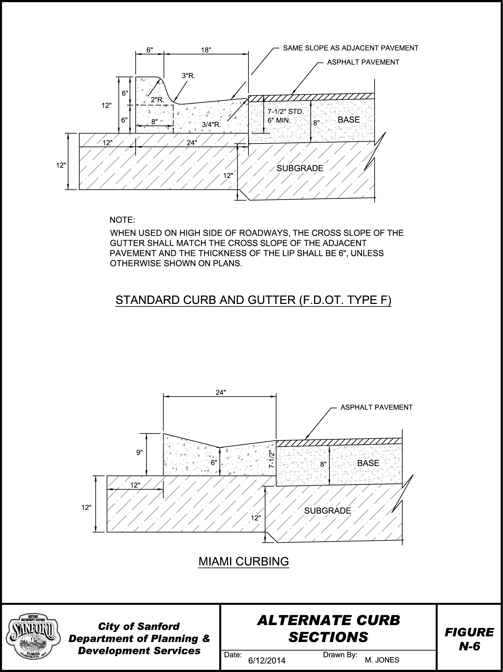
Curb and Gutter Required. All streets shall be provided with curbs. Standard curb and gutter (Type F) or Miami curb types shall be utilized for all streets provided that flush curb types shall be permitted when rural type street sections are utilized. Curbs shall be of integral type and shall conform to specifications illustrated on Figure N-6. Construction of curb and gutter of materials other than Portland Cement concrete shall not be acceptable.
1.
Curbs in Parking Areas. Curbs used in parking lots shall be poured in place Portland Cement Concrete. Bumper stops shall be concrete and may be preformed.
2.
Strength Requirements. Concrete for all curb and gutter and driveway aprons shall have a 28 day compressive strength of at least 3000 PSI.
3.
Joints. Where metal templates are used for joint construction, the curb and gutter shall be constructed in uniform sections 10' in length except where shorter sections are necessary for closures, but no sections shall be less than 4'. Sections may be formed by the use of construction joints or by the use of metal templates. If metal templates are used they shall be held firmly in place during the pouring of concrete and shall be left in place until the concrete has set sufficiently to hold its shape. Contraction joints shall be constructed at all inlets, all radius sections, and all points where operation cease for any.
4.
Curb and Gutter Machine. Should the contractor elect to use a curb and gutter machine, the track of the machine shall be placed on a thoroughly compacted and stable subgrade which will not yield under the weight of the machine. In no case will loose material be permitted under the track. As a specific requirement for machine-laid curb and gutter contraction joints shall be sawed at intervals of 10' feet except where shorter intervals are required for closures, but no joints will be required as in set forth in Paragraph 3. above for machine laid curb and gutter.
L.
Headwalls. Headwalls, inlets and bridges shall be designed in accordance with Florida Department of Transportation's Standard Specifications for Roads and Bridges Construction, latest edition.
M.
Specifications for Miscellaneous Concrete Improvements. Concrete project improvements shall have a minimum compressive strength of 3,000 PSI Forms for such improvements made of either wood or metal. They shall be straight, free from warp or bends, and of sufficient strength, when staked, to resist the pressure of the concrete without springing. If of wood, they shall be of approved section and shall have a flat surface on top. For all curb and gutter constructed on a radius, the contractor will be required to use flexible forms, unless otherwise permitted by the engineer. Forms shall have a depth equal to the plan dimensions for the depth of concrete being deposited against them.
1.
Placing Concrete. The concrete shall be placed in the forms to the depth specified in layers four or five inches thick, and tamped and spaded until mortar entirely covers its surface. The top of the structure shall be floated smooth and the edges rounded.
2.
Temperature Limitation. No concrete shall be placed when the atmospheric temperature is below 35 degrees F. After concrete has been placed, if the temperature drops below 35 degrees F. during curing, the concrete shall be adequately protected.
3.
Curing. Curing materials shall be white-pigmented membrane curing compound, wet burlap or polyethylene film. At no time shall more concrete be laid than can be immediately and properly covered, nor when already laid is not being properly covered, nor when already laid is not being properly cured. Failure to provide sufficient cover material or sufficient water to adequately take care of curing and all other requirements shall be cause for immediate suspension of concreting operations. The entire surface of the concrete shall be cured for a total period of at least 72 hours, except where high-early-strength cement is used this total curing time may be reduced to 48 hours.
4.
Expansion Joints. Expansion joints shall be constructed at all inlets, all radius sections, all points where operations cease for any considerable time, such as the end of the day's run, etc., and at intervals of not more than 150' on straightaways.
(Ord. No. 4612, § 1(a)(Exh.), 6-28-2021)
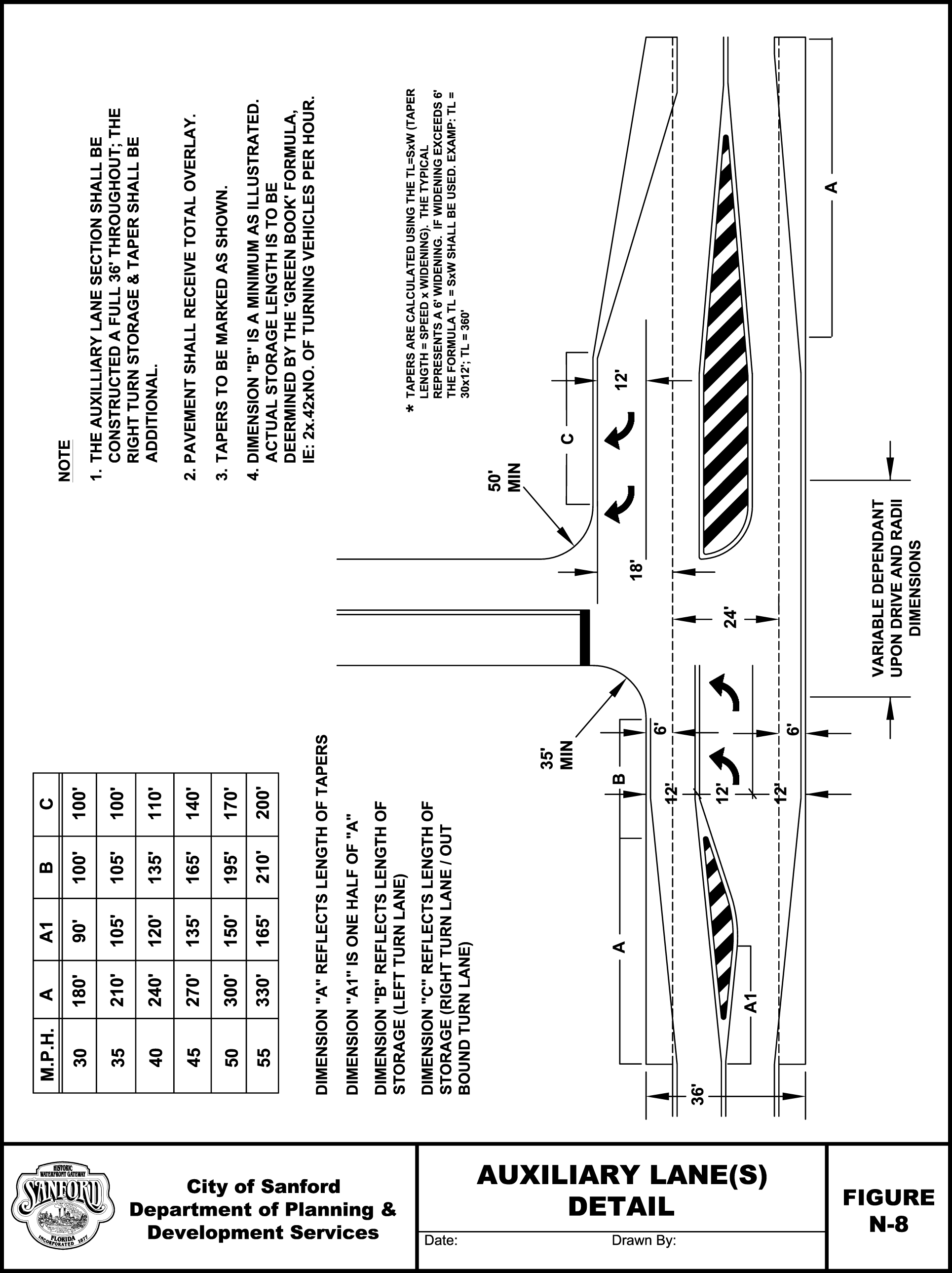
Section 4.1. - Auxiliary lanes (right & left turn lanes).
The principal thrust in the development of marginal access standards is to reduce conflict between driveway entrances and through traffic. One method of reducing conflict is to provide a refuge area where vehicles can leave the through traffic lanes, slow down and accomplish the turn. Auxiliary lanes, as defined below, provide that capability and consequently may be required based upon the speed of the accessed roadway, the development's projected right and left turn volumes, and/or construction conflicts with existing drives/streets/roads.
A.
Requirements. A right turn section is required on roadways with a posted speed limit of 40 MPH and greater and/or development with a daily trip end rate of 500 ADT or greater.
A left turn lane section is required for any development that accesses a classified road of minor collector and above or has a posted speed of 35 MPH or higher. An inbound radius of 50' at development or higher, or a daily trip end rate of 500 ADT or higher, then a right turn section will be additionally required.
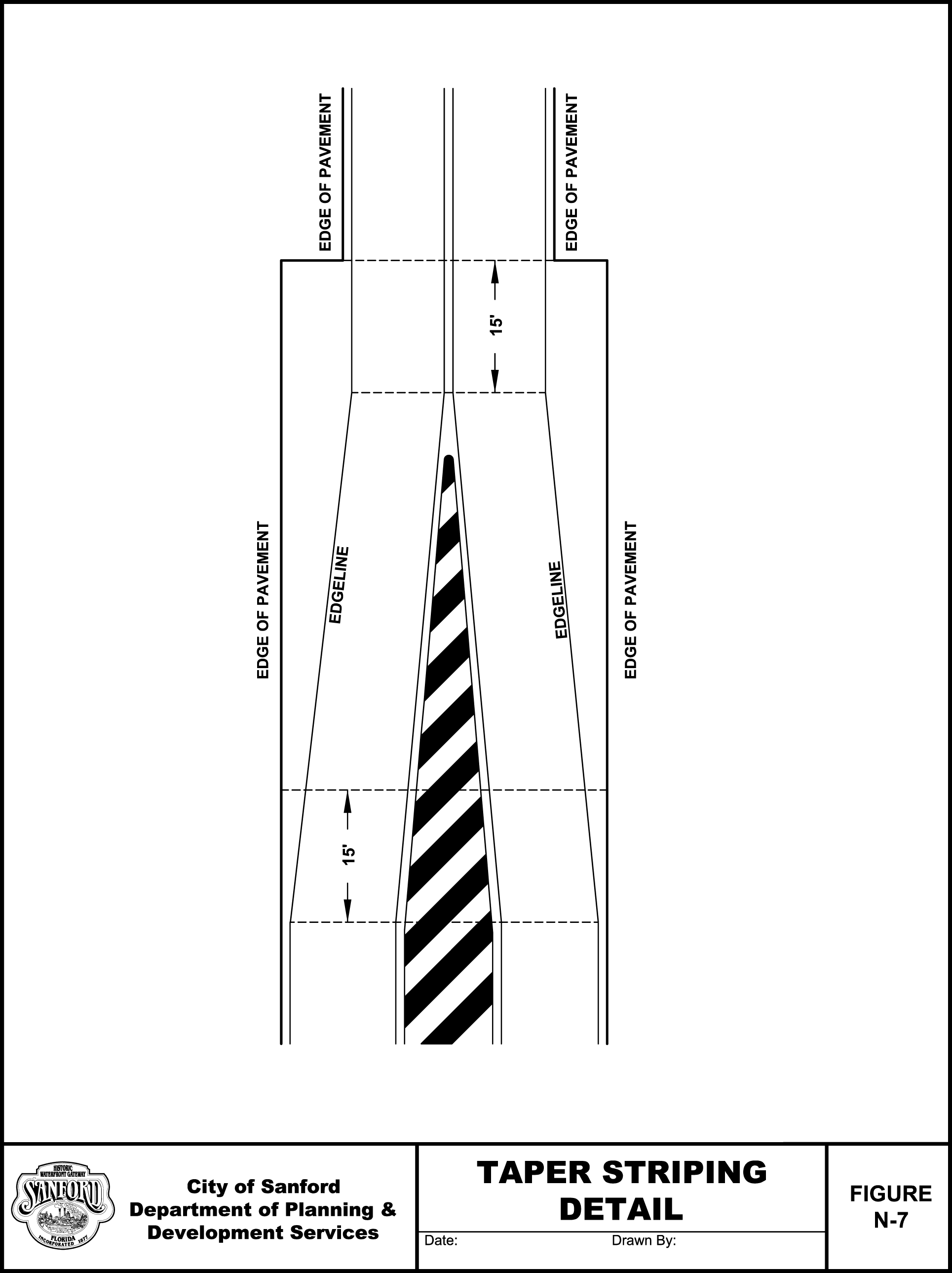
Additionally, if either terminus of the of the proposed auxiliary lane section is within 300' from an existing auxiliary lane terminus than a total 36' section is required to eliminate weaving or "Hour Glass" sections. See Figure N-7, Taper Striping Details, for design and markings specifications.
B.
Figure N-8, Auxiliary Lane(s) Detail illustrates typical taper dimensions "A". A taper refers to the triangular paved surface that transitions the highway pavement to accommodate an auxiliary lane or a 36' wide pavement surface with markings identifying the transition area for the same purpose.
The length of the taper is based on a roadway's design speed; i.e., L = Speed x Width. Examples of taper length are given for different design speeds in Figure N- 8, Recommended Taper Length for Various Design Speeds. Storage lanes, labeled "B" and "C" in Figure N-8, are the 12' "refuge" area used to accomplish a right or left turn without impeding traffic. The storage and tapers combine to form either the right or left turn lanes. The length is determined as shown in Figure N-8.
C.
Exceptions. The Administrative Official has the authority to adjust the requirements due to right-of-way constraints.
(Ord. No. 4612, § 1(a)(Exh.), 6-28-2021)
Section 5.1. - Access standards.
A.
Purpose. The purpose of these access standards is to protect roadway operations and the roadway capacity by ensuring the adequate functioning of intersections and the adequate design, efficient operation and continued maintenance of the road facilities.
B.
General Access Standards. The following access standards shall apply:
1.
Minimum number of access points shall adequately serve the development. Joint and Cross Access Easements and dedication of access rights may be required to protect the safe and efficient operation of the accessed streets.
2.
In order to provide ease and convenience in ingress and egress to private property and the maximum safety with the least interference to the traffic flow on public streets, classified major collector and above, the number and location of driveways shall be regulated by the dedication of access rights to the City or other governmental entity that has jurisdiction over the road.
3.
Street stubs to adjoining undeveloped areas shall be provided when required to give access to such areas or to provide for proper traffic circulation. Streets stubs in excess of 250' shall be provided with a temporary cul-de-sac turnaround.
4.
Auxiliary lanes, median modifications or other design features may be required.
5.
All lots shall front on a paved road. A development shall abut, or have as its primary access, on a street paved to City standards of this regulation. All abutting roadways providing direct access to the development shall be paved to the nearest public paved road. Where paving is required on the abutting roadway outside of the development frontage, then paving only to the development access points may be allowed provided that in no case shall the length of required paving be less than the length of the development's frontage along the abutting roadway.
6.
The following permits are required prior to a building permit being issued:
a.
An FDOT driveway permit is required for all proposals to access State roads.
b.
A Seminole County driveway or access permit is required for all proposals to access any County right-of-way or easement.
c.
A City permit is required for all proposals to access City right-of-way.
7.
All nonfunctioning roadway access points shall be removed. All unpermitted or hazardous roadway access points shall either be removed or reconstructed to City standards. All disturbed rights-of-way shall be restored to State, County or City standards as determined by the roadway's jurisdiction.
8.
Accessways designed to serve nonresidential uses shall not be permitted to be located in residential zoning districts, including, but not limited to, the agricultural zoning district or in the residential areas of a Planned Development (PD) zoning district. Design of driveways serving non-residential developments shall not direct traffic into residential areas.
9.
Prior to any form of vertical construction, a stabilized access and functioning fire hydrant shall be in place on any construction site.
C.
Access Limitations.
1.
No new residential development shall create any parcels zoned for single-family or duplex residential uses having access on an arterial.
2.
Parcels created after adoption of this Schedule shall have a minimum of 200 linear frontage feet in order to gain access to the arterial unless one of the following conditions is met:
a.
Access to the lot is provided jointly through existing cut(s) of an adjacent property.
b.
Access to the lots is to be provided from a frontage road paralleling the arterial that has been planned and officially approved by the County.
c.
For corner parcels, access will be provided to the collector facility or lower classification where minimum arterial frontage requirements are not satisfied.
D.
Number and Spacing of Driveways. The minimum number of driveways necessary to adequately accommodate access to and from the site will be permitted.
1.
Spacing between driveways shall conform to the table below based on functional classification. Distance is measured from nearest edge to edge.
Minimum Separation
2.
Driveways on opposite sides of any undivided street classified local, collector or arterial shall either be aligned on the same centerline or be offset a minimum of 200' measured from centerline to centerline.
3.
For developments that request more than one two-way driveway, based upon parcel size, projected trip generation of the site, amount of roadway frontage and other appropriate design considerations, additional driveways may be permitted if all other provisions of the standards are met.
E.
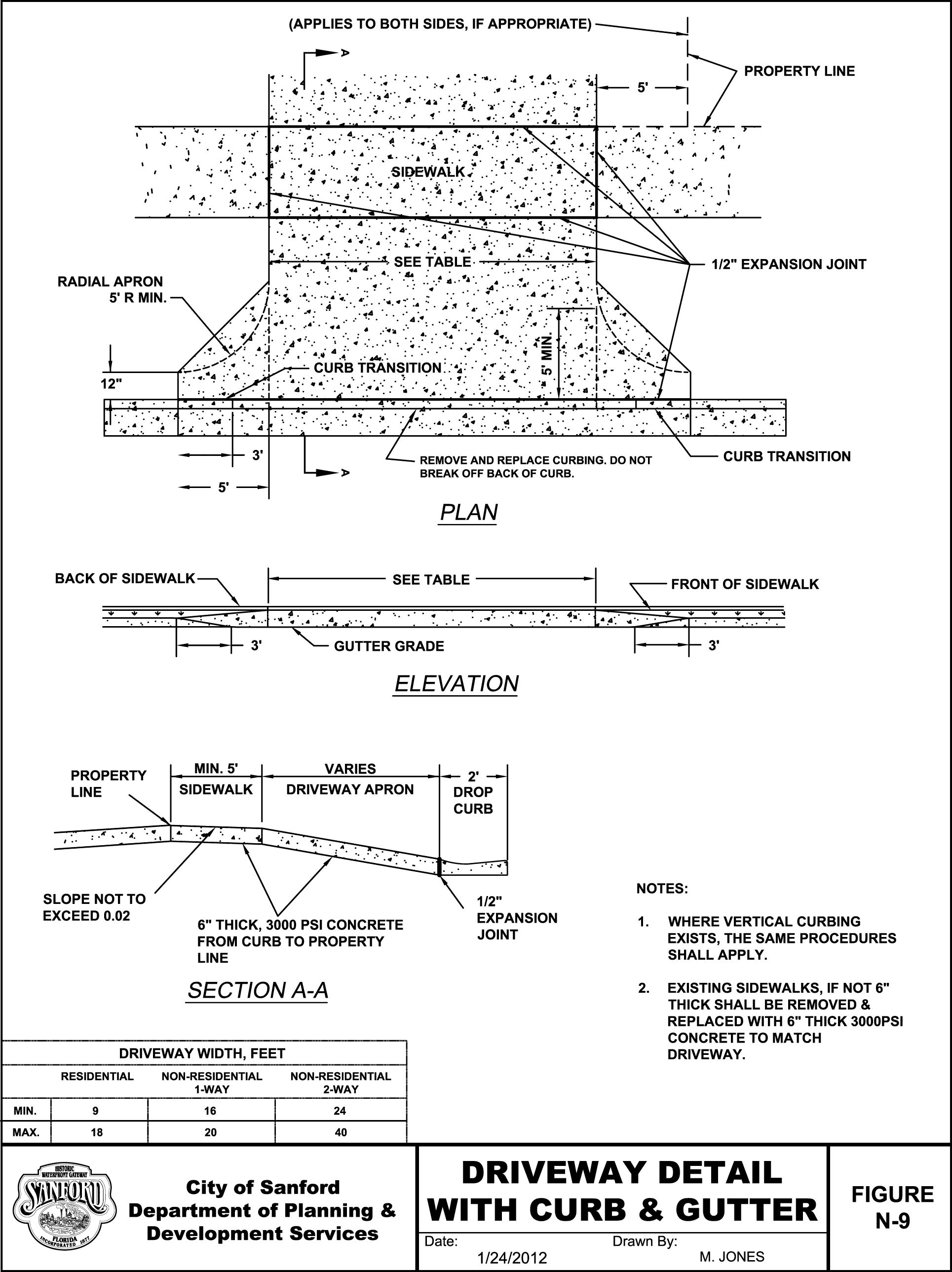
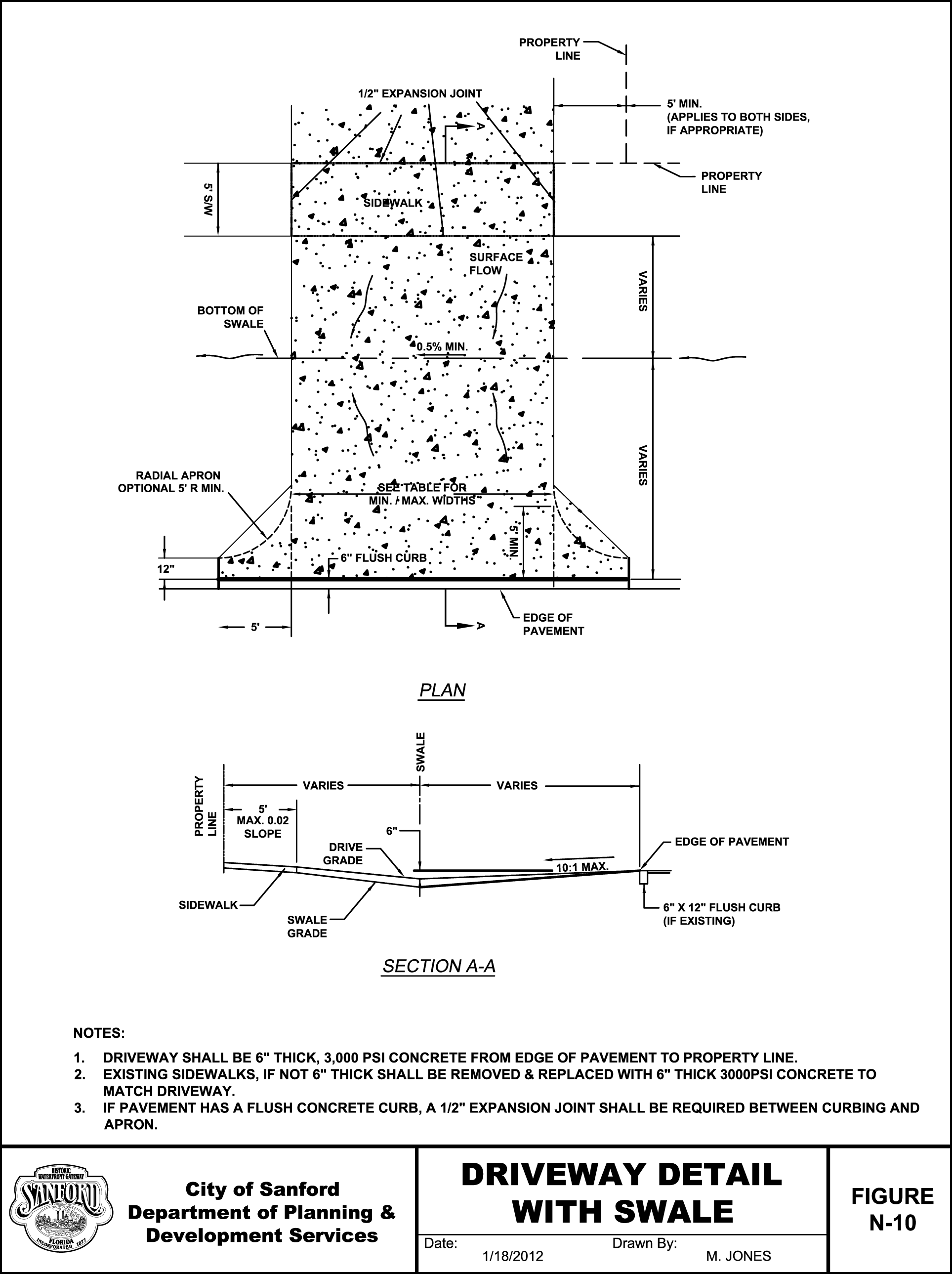
Driveway Design. Driveway design will vary depending upon a number of conditions including functional classification of the accessed roadway, land use requiring the driveway, projected ADT and/or peak hour traffic using the driveway, vehicle type(s) using the driveway, speed limit of accessed roadway and other design features of the site itself or surrounding area. See figures N-9 and N-10 for details of driveway design.
Driveway Types:
1.
Minor Driveway - The minimum separation distance from the edge of pavement at any ingress or egress minor driveway to the edge of pavement of an existing or planned adjacent driveway or street shall be 50'. This type of driveway should provide service for a maximum of an average peak hour inbound right turn volume of 40 vehicles. Minimum return radii shall be 35' from the edge of pavement.
2.
Intermediate Driveway - The minimum separation distance from the edge of pavement at any ingress or egress intermediate driveway to the edge of pavement of an existing or planned adjacent driveway or street shall be one hundred 100'. This driveway should provide for a maximum average daily trip volume of 2,000 vehicles and/or a maximum average peak hour volume of 200 vehicles. Minimum radii shall be 35' from the edge of pavement.
3.
Major Driveway - The minimum separation distance from the edge of pavement at any ingress or egress major driveway to the edge of pavement of an existing or planned adjacent driveway or street shall be 200'. This driveway should provide for a maximum average daily trip volume of 5,000 vehicles and/or a maximum average peak hour volume of 500 vehicles. Minimum return radii shall be 50' from the edge of pavement.
Driveway Widths
4.
Access drives that are limited to right-in/right-out shall have a concrete island using mountable FDOT curb.
(Ord. No. 4612, § 1(a)(Exh.), 6-28-2021)
Section 5.2. - Common vehicular access points.
A.
Applicability. The Administrative Official shall require the provision of common vehicular access points between abutting lots or tracts when all of the following criteria are met:
1.
The proposed use is nonresidential.
2.
The lot or tract has frontage on a street classified as a major thoroughfare in the City's Comprehensive Plan.
3.
The provision of common vehicular access points and related common access ways will help mitigate future adverse transportation impact of the proposed use upon traffic safety and vehicular operating capacity of the major thoroughfare in question.
4.
The existing or anticipated land uses adjacent to the lot or tract in question are generally of a similar or compatible character to the proposed use of the lot or tract in question.
5.
The provision of common vehicular access points between lots or tracts is not impractical due to the configuration of existing buildings, structures or other related circumstances.
B.
Design of Common Vehicular Access Points. When common vehicular access points are required, the following design criteria shall apply:
1.
Common vehicular access points shall provide two-way traffic circulation to accommodate a 12' wide access way in each direction.
2.
Common vehicular access points should be located between the parcel line with frontage on the major thoroughfare and the required front yard building setback or base building line, whichever is greater.
3.
Stub-outs and other design features shall be provided to the parcel line in question in order to tie together on-site vehicular traffic circulation of abutting properties.
4.
Off-street parking, common vehicular access ways and related facilities shall be arranged in a manner that coordinates on-site vehicular circulation between abutting lots and tracts.
C.
Submittal of Draft Common Vehicular Access Point Agreement. When a common vehicular access point agreement is required, a draft of such agreement, easement or other similar instrument shall be submitted with a proposed site plan or a proposed preliminary subdivision plan, whichever is applicable, for review and approval by the City Attorney.
D.
Recording and Evidence of Common Vehicular Access Point Agreement. All common vehicular access point agreements, easements or other similar legal instruments required by the provisions of this Schedule shall be in a form approved by the City Attorney and recorded in the Official Record of the County. A copy of such recorded agreement, easement or instrument shall be provided to the Administrative Official prior to the issuance of a site development permit or certificate of completion.
E.
Identification of Common Vehicular Access Point Agreements on the Zoning District Map. Upon receipt of evidence of common vehicular access point agreement, the Administrative Official shall cause such agreement, in a form approved by the City Attorney, to be recorded in the Official Records of the County.
F.
Temporary Vehicular Access Points. When the lot or tract in question is developed prior to an abutting lot or tract, a temporary vehicular access point on a major thoroughfare may be approved by the Administrative Official provided, however, that a condition of approval of such temporary vehicular access point shall be removal of same when development of the abutting lot or tract provides common vehicular access and a coordinated system of on-site traffic circulation for both premises. The Administrative Official shall notify the owner of record of the parcel in question as to when the temporary vehicular access point shall be removed and any applicable conditions for its removal. The owner shall be responsible for all costs involved in removing the temporary vehicular access point.
(Ord. No. 4612, § 1(a)(Exh.), 6-28-2021)
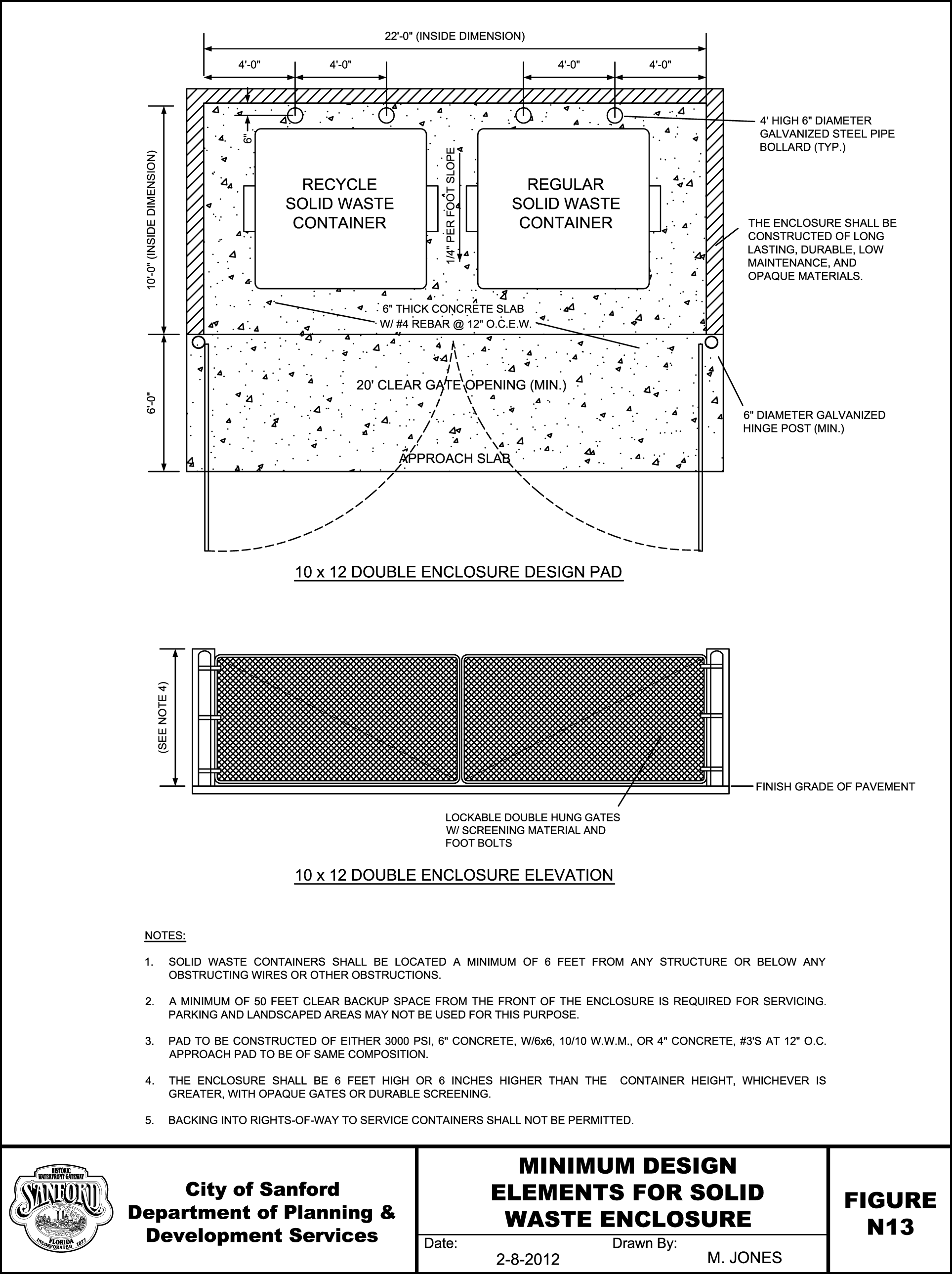
Section 6.0. - Solid waste container requirements.
A.
Front End Loaded Refuse Container Location Requirements. No FEL refuse container shall be located within any required front or street side yard setback. No such container shall be located in any required parking space or vehicular use area, or in any required buffer yard or landscaping area.
1.
Service Access. FEL refuse container sites shall be provided which allow refuse vehicle service access without manually moving the container(s) of service. 50' of clear backup as measured perpendicular from the screen areas shall be provided from the face of the refuse containers' screening unless otherwise approved by the City upon a finding being made that the reduction is necessary to provide property right enjoyed by others in the same zoning district, and will not be detrimental to public health, safety, and welfare. No encroachment into this area by parking spaces, non-driveway sidewalks, or landscape areas shall be allowed.
2.
Siting Obstructions. No FEL refuse container shall be sited within 6' of any building/structure, nor sited below obstructing roofs, eaves, or wires nor sited adjacent to any other obstruction to the container dumping process. The Administrative Official may approve an exception to this is if the enclosure is designed as part of the main building it serves such as a restaurant.
3.
Container Pads. FEL refuse container pad(s) shall be provided for all rear end loader containers and shall be constructed either of, as a minimum 3,000 PSI concrete 6" inches thick with 6" x 6" - 10' x 10' wire mesh or #3 steel reinforcing bars on 12" centers in each direction, or as approved by the City upon a finding being made that the reduction is necessary to provide property rights enjoyed by others in the same zoning district, and will not be detrimental to public health, safety and welfare. A 6' long approach slab of identical width, thickness, and composition to the container pad shall also be constructed adjacent and of equal slope to said pad(s).
4.
FEL Refuse Container Screening Requirements. FEL refuse containers shall be opaquely screened from view from public streets and adjacent properties to a height of at least 6', or 6" higher than the height of the container (whichever is higher). This screening may be achieved by walls, landscaping or buffer yards, or by virtue of the location of the container on the building site.
5.
Drains. Drains for the dumpster container pad shall not discharge into the stormwater system. Drains that connect to the sanitary sewer system shall be covered in a manner to prevent rain water getting into the drain and into the sanitary sewer system.
B.
Roll-off Compactor Container Location Requirements.
1.
Container Pads. Roll-off compactor container pad(s) shall be provided for all roll-off compactor containers, and shall be constructed of minimum 3,000 PSI concrete, steel reinforced, 6" thick, and shall comply with the following minimal dimension requirements for each container: 10' wide by 20' long.
2.
Service Access. A paved service vehicle access apron constructed to a minimum HS-20 capacity requirement and extending a minimum of 45' in front of each roll-off compactor container is required. Service height clearance of 25' is required in the container service access area.
3.
Electrical Requirements. The industry recommendations for roll-off compactor electrical requirements are: 3 phase, 460-480 volt, 60 amps. electrical service to each compactor location. Other electrical requirements may be approved by the City.
(Ord. No. 4612, § 1(a)(Exh.), 6-28-2021)
Section 7.0. - Materials and testing.
The owner shall retain an independent testing laboratory. The testing laboratory performing field sampling and field testing shall be certified by the American Concrete Institute. Testing results shall be signed by a licensed professional engineer. Testing of materials set forth in this Schedule shall conform to the following requirements and procedures:
A.
General Testing of Materials. Testing procedures shall provide the following information to the Administrative Official:
1.
Subgrade and shoulders. Width, depth, LBR and density.
2.
Base. Width, depth and density.
3.
Surface. Width, depth, extraction, gradation, density, asphalt content and stability.
4.
Soil cement. Conform to Portland Cement Association specifications.
B.
Concrete. Concrete shall have a minimum compressive strength of 3,000 PSI unless otherwise prescribed in these Land Development Regulations. Test requirements applicable to concrete shall be as follows:
1.
Test core cylinders spaced at maximum intervals of 100' shall be required.
2.
The Administrative Official shall exercise the authority to prescribe frequency of truck loads of material from which a cylinder shall be taken based upon public safety issues and related pertinent development issues.
3.
The testing laboratory shall conform to the applicable requirements of ASTM E329-77 (1983) Standard Recommended Practice for Inspection and Testing Agencies for Concrete, Steel and Bituminous Materials as Used in Construction.
4.
The mixture shall contain no more water than is necessary to produce concrete that is workable and plastic. The minimum slump necessary to place the concrete satisfactorily shall be used. Slumps shall be maintained so as not to exceed 2"—4 ½" for nonvibrated placement and 3", plus or minus, 1 ½" for vibrated placement.
5.
The concrete shall be tested for compressive strength and copies of results of such tests shall be submitted to the Administrative Official.
6.
All concrete test failures shall result in removal of the section in question by the developer or such other action shall be taken as directed by the Administrative Official. Additional testing may be required prior to removal in case of a bad cylinder.
C.
Asphalt. Certification of conformity to the Standard Specifications for Road and Bridge Construction, latest edition shall be provided.
D.
Sidewalks. Testing of sidewalks shall not be required unless otherwise prescribed by the Administrative Official based up sound and generally accepted development standards and principles.
(Ord. No. 4612, § 1(a)(Exh.), 6-28-2021)
Section 8.0. - Construction and inspection by the City.
Any work requiring a City inspection shall be accomplished during normal working hours unless prior arrangements are made to facilitate such inspections and all fees are paid in advance with an additional fee for after hour inspections.
(Ord. No. 4612, § 1(a)(Exh.), 6-28-2021)