
Starkville City Zoning Code
SECTION 10
Optional District
10.1.1 General Purpose
The intent of the Optional district is to allow the following four (4) distinct use categories, or any combination thereof, that can be applied by right within the Optional District (O) zone with the approval of a conceptual master plan:
- (O-C) Commercial
- (O-I) Industrial
- (O-TND) Traditional Neighborhood Development
- (O-CD) Conservation Development
10.1.2 Conceptual Master Plan
The optional district is a zone that allows for use categories to be applied with the approval of a conceptual master plan.
10.1.3 Subdivided Property
Any property that is subdivided for development within an Optional District, shall be required to follow the process for Procedures for Review and Approval of Conceptual Master Plan in Optional District in Section 3.3.
10.1.4 Regulated In Accordance With Development Standards
Until the conceptual master plan has been approved, property within the Optional District shall be regulated in accordance with the development standards and use standards for Optional Existing (O-E) use category
10.1.5 New Development Or Modification Of Existing
Any new development or modification of an existing development on a parcel that existed at the time of adoption of the Unified Development Code within the Optional district, shall use the principal building setbacks, accessory dwelling unit setbacks, accessory structure setbacks, parking setbacks, principal building height, accessory dwelling unit height, and accessory structure height in accordance with the following:
- Residential Use. Any permitted residential use shall use the Rural Neighborhood requirements in Section 6.3.
- Commercial Use. Any permitted non-residential use shall use the Commercial Rural requirements in Section 7.2.
10.2.1 The Optional Traditional Neighborhood Development
The Optional Traditional Neighborhood Development (O-TND) use category offers a mixture of uses in an urban form. Housing and commercial uses can occur in a variety of types and densities and the overall design should result in a pedestrian-friendly place.
10.2.2 The Optional Conservation Development
The Optional Conservation Development (O-CD) use category is a residential development pattern that allows for clustering of housing to result in a preserved open space.
10.2.3 The Optional Industrial Development
The Optional Industrial Development (O-I) use category is designed to provide a well-designed “campus” style space with unifying elements for streets, landscaping, signage, and architecture. The intent is to allow for large scale master planned developments for manufacturing, assemblage, warehousing, research, distribution, operation, and/or data processing centers.
10.2.4 The Optional Commercial Development
The Optional Commercial Development (O-C) use category allows for a range of commercial uses, including retail, dining, personal services, professional services, office, and other related uses. The intent of this option is to allow for large scale master planned developments to serve not only the local but also the regional market needs in addition to smaller scaled commercial uses.
10.2.5 The Optional Traditional Neighborhood
The Optional Traditional Neighborhood (O-TN) use category allows for traditional neighborhoods with a range of housing types and limited small-scale commercial uses.
10.3.1 Use Category
A Traditional Neighborhood Development (TND) use category is compact and pedestrian friendly development containing a mix of land uses with a defined center, middle, and edge in an urban village type setting.
10.3.2 Minimum Gross Site Area
The minimum gross site area to implement the use category of optional Traditional Neighborhood Development Option is thirty (30) acres. If a proposed residential development does not meet the minimum gross site area requirement, the applicant can apply to rezone the subject property or portion thereof to TN-N and develop under TN-N zoning district
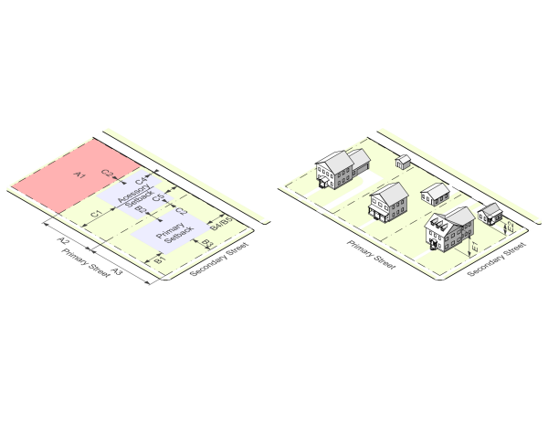
10.3.3 Base Dimensional Standards
Optional Traditional Neighborhood Development |
| |
Site |
|
|
A1 Gross site area (min) | 30 acres | |
B. Structural Elements | Uses | Land Allocation % (min/max) |
B1 Neighborhood Core | civic, retail, office, lodging, townhouse, rowhouse, and mixed-use structures with open space uses | 10/20 |
B2 Neighborhood Transition | townhouse, rowhouse, dwelling attached duplex, dwelling attached triplex, and dwelling detached | 25/35 |
B3 Neighborhood Edge | dwelling attached duplex, dwelling attached triplex, and dwelling detached | 45/60 |
10.3.4 General Access And Layout
- Streets- for Traditional Neighborhood Developments located adjacent to a local, collector, or higher classification street, and the street is not designed to conform to the standards of an “Avenue” or “Main Street” street type, the following criteria shall apply:
- The internal streets providing access to the development shall be aligned to intersect the existing streets perpendicularly.
- The buildings or structures that take access from internal streets are to face the internal streets and not a collector or higher-order streets. However, fenestration will be required on all facades adjacent to a higher-class street.
- A network of sidewalks connecting all roads shall be required.
- Variable Block Lengths- Blocks are to have an average length not to exceed four hundred (400) feet, with no block exceeding eight hundred (800) feet in length. No block face should have a length greater than four hundred (400) feet without a dedicated alley or pathway providing through access to the opposite side of the block.
10.3.5 Lot Arrangement
All lots are to include frontage abutting a street, park, or plaza. A substantial percentage of the dwelling units are to be located within a five (5) minute walk (1,320 feet) from the perimeter of a plaza or park as noted below:
- For a proposed O-TND less than eighty (80) acres in size, at least ninety (90) percent
- For a proposed O-TND of eighty (80) to ninety (90) acres in size, at least seventy (70) percent
- For a proposed O-TND of ninety (90) or more acres in size, at least fifty (50) percent
10.3.6 Neighborhood Structural Element Standards
- Neighborhood Core Area
- Parks, plazas, and open spaces are to be sited to provide community focal points and public gathering places.
- The focal area must have a minimum area of 30,000 square feet. The neighborhood core may face or surround the plaza or square.
- Neighborhood Transition Area- The generally residential area, which may have limited commercial uses, but is primarily a mix of residential types, located between the core and edge areas.
- Neighborhood Edge Area- A greenbelt (a substantial area of woods, parks, or open land surrounding a community on which building is restricted) shall be sited that will provide a clear edge to the community, open space for community residents, and natural areas for stormwater management.
- Common open areas may include, but are not limited to: stormwater management facilities, playgrounds, club houses, parks, green spaces, conservation land, and other amenities
10.3.7 Density Standards
The requested densities, in terms of number of units per gross acre and total number of dwelling units, are to be established in the Master Regulating Plan and are to comply with the density parameters set out in the O-TND Density Table.
O-TND Density Table | ||||
Use Category | min./max Land Allocation | min./max Density for Residential | min. Story/Height | max. Story/Height |
Common open space | 10% min. | - | - | - |
Civic uses | 2.5% min. 20% max. | - | - | 2.5 stories/35’ |
Retail (4), office uses, lodging | 2.5% min. 20% max. | - | 2 stories/30’ (1) | 3 stories/40’ (2) |
Mixed use building with retail and office uses on the ground floor (6) (8) | - | 22 max. units per acre | 2 stories/30’ | 3 stories/40’ (2) |
Townhouse/Rowhouse dwelling (6) | 5% min. 15% max. | 15 min./22 max. units per acre | 2 stories/30’ | 2.5 stories/35’ (3) |
Dwelling attached duplex and triplex (5) (6) and dwelling, detached (7) | 15% min. 50% max. | 6 min./12max. units per acre | - | 2 stories/30’ (3) |
Dwelling, detached (7) | 25% min. 50% max. | 4 min./6max. units per acre | - | 2 stories/30’ (3) |
(1)- 1 story by special exception | (5)- dwelling attached duplex and triplex are single structures containing 2-3 dwelling units. | |||
(2)- 4 stories by special exception | (6)- A maximum of 3 bedrooms per unit unless a 4th bedroom is approved as part of the special exception | |||
(3)- 3 stories by special exception | (7)- Accessory dwelling units allowed by special exception for dwelling detached only. | |||
(4)- Single store footprint greater than 25,000 square feet permitted only by special exception | (8)- First floor residential by special exception. | |||
10.3.8 Prominent Sites And Vistas
- Prominent sites are reserved for the following uses and the associated building types:
- Civic buildings, such as but not limited to: government offices, libraries, museums, schools, or a place of religious assembly.
- Hotels or office buildings.
10.3.9 Prominent Site Height
Buildings located on a prominent site shall be at least two (2) stories high. A “prominent site” may include a location along a main street, or the termination of a vista running from a main street, boulevard, or avenue and its intersection with an equal or lower- order street.
10.3.10 Frontage And Siting Standards
- Location of Uses - The location of uses is to be governed by street frontage as shown in O-TND Use Location Table. Street type design is set out in the comprehensive plan.
- Building Lines - The setback for principal buildings are to be as established in O-TND Setback Table. Accessory dwelling units shall be located behind the rear wall of the principal building(s). Accessory dwelling units on corner lots shall face the secondary street and follow the O-TND Setback Table. Accessory structures shall follow the additional use standards for that use.
- Frontage and setback requirements do not apply to parks and open space in the optional Traditional Neighborhood Development. In order to allow for setback variations for unique uses, such as anchor retail tenants or auditoriums, the maximum frontage requirements along a street segment are to be computed as an average.
O-TND Use Location Table | ||||
Street Type | Civic Uses | Retail or Service Uses | Multi-dwelling Unit Residential Uses | Detached Single Dwelling Unit Uses |
Parkway | x | - | - | - |
Boulevard | x | x | x | - |
Main Street | x. | x | x | - |
Avenue | x | x | x | - |
Local | - | -. | x | x |
Alley or Lanes | - | - | - | x |
x = the use or building type is permitted. A dash (“—”) means that the use or building type is not permitted. | ||||
O-TND Setback Table | |||||
Street Type | min. Frontage | max. Frontage | min/max. Front setback | min/max. Side setback | min. Rear setback |
Parkway | 100’ | - | 10’/30’ | 5’ /- | 20’ |
Boulevard | 40’ | 80’ | 5’/30’ | 20-May | 20’ |
Main Street | - | 40’ | - /5’ | - /5’ | 5’ |
Avenue | 20’ | 40’ | 5’/20’ | 20’/5’ | 20’ |
Local | 20’ | 70’ | 5’/30’ | 30’/5’ | 20’ |
Public Alley or Lanes | 20’ | 70’ | 5’/30’ | 30’/5’ | 20’ |
Private Alley | 20’ | 70’ | 5’/30’ | -/5’ | 7’(1) |
(-) = not applicable. (1) If no parking allowed. | |||||
See section 15.4.2. Street Types for street standards | |||||
10.3.11 Building Design
- Building designs are to reflect a demonstrated relationship to historic architecture in the Starkville’s historic districts.
- The principal entrance of all principal buildings must open to a street. The principal entrance to any accessory dwelling adjacent to a street shall open to the adjacent street.
- All principal buildings are to be oriented to parks and open space or to a street. Loading areas must not be visible from any street. Buildings that abut both a street and park or open space are to be oriented to both features.
- Front porches are to be provided on at least fifty (50) percent of all detached dwelling units. Porches are to be constructed of masonry or wood materials. Architectural metal on porches may be used if it is consistent with the exterior or roofing materials of the principal building. The seating area must have a minimum width of nine (9) feet and a minimum depth of 6 feet.
- Street facing balconies shall be provided on at least fifty (50) percent of all upper floor residential dwelling units in a mixed-use building.
- Retail and service uses may designate the entire building area above the ground floor or the second floor for residential use. The submitted floor plans must identify the use of each room.
- Buffer requirements do not apply to the Optional Traditional Neighborhood Developments between different uses.
- No single building floor plate (first floor size) may exceed 25,000 square feet without approval by a special exception.
10.3.12 Landscaping And Screening
- See Section 15 Development Standards.
10.3.13 Parking
- See development standards for parking lot requirements and use standards for required amount of parking.
- Parking lots shall be located at the rear of principal buildings or in mid-block locations.
- Parking lots and parking garages shall not abut street intersections or civic use lots.
- Parking lots shall not be located adjacent to parks or open space.
- Parking lots shall not occupy lots that terminate a street vista.
- Parking lots shall be located in the interior of a block or take access from an alley.
10.3.14 Configuration Of Common Open Space
- The minimum width for any required open space is fifty (50) feet.
- A pedestrian crosswalk provides access to the open space on both sides of the street.
- The right-of-way is not included in the calculation of minimum open space required.
- Where feasible, the open space should adjoin any neighboring open space, other protected areas and non-protected natural areas.
- The required open space must be directly accessible to the largest practicable number of dwelling units within the development. Non-adjoining lots must be provided with safe and convenient access to the open space by a hard-surfaced walkway.
- No lot in a development can be farther than a ¼ mile radius from the common open space. This radius is measured in a straight line from the lot line, without regard for street, sidewalk, or trail connections, to the nearest point of the open space.
- Access to the open space must be provided either by an abutting street or easement not less than twenty (20) feet in width.
10.3.15 Allowed Uses Of Open Space
To the extent not otherwise prohibited, required open space may be used for the following:
- Conservation areas for natural, archeological, or historical resources.
- Meadows, woodlands, wetlands, wildlife corridors, or similar conservation-oriented areas.
- Pedestrian or multipurpose trails
- Passive recreation areas
- Active recreation areas, provided that impervious area is limited to no more than twenty-five percent (25%) of the total open space
- Water bodies, such as lakes, ponds, and floodways provided that the total surface area does not exceed fifty percent (50%) of the required open space
- Restricted agriculture such as community gardens.
- Stormwater control measures
- Easements for drainage, access, and underground utility lines.
10.3.16 Stormwater Control Measures
No more than twenty-five percent (25%) of the required common space shall be devoted singularly or collectively to detention or retention ponds. However, this requirement shall not apply to retention ponds that meet all of the following criteria:
- The retention pond or closely connected series of ponds has at least 20,000 square feet of water surface area at normal water level.
- The retention pond is surrounded by accessible open space
- The retention pond is accessible to all property owners
10.3.17 Prohibited Use Of Open Space
Required common open space cannot be used for the following:
- Overhead electric transmission lines or high voltage electrical transmission lines
- Telecommunication towers
- Water towers
- Streets and parking areas. Streets crossing open space are allowed but should be avoided if possible.
10.3.18 Ownership And Maintenance Of Common Open Space
- A plan for an Optional Traditional Neighborhood Development must be accompanied by provisions for a property owners association for the maintenance and ownership of all common open space and shall include the following:
- Projected date of organization.
- Organizational structure, including structure of planned timeline for transfer of control from the developer to the property owners’ association.
- A plat showing areas to be held in common.
- Initial estimated fees for the proper functioning of the property owners’ association.
- Plan for collective shared maintenance of common open space including stormwater management facilities.
- Before building permits are issued for any building in an approved Traditional Neighborhood, official organization of the applicable Property Owners Association must have occurred.
- Ownership- Required open space shall be owned and maintained by a property owners association representing property owners of the development. The property owners’ association must have lien authority to ensure the collection of dues from all members. The responsibility for maintaining the open space and any facilities is borne by the property owners association. All of the above shall be specifically addressed in the covenants filed for the development.
- Conveyance- The conveyance of common open space shall be in accordance with the following:
- Common open space shall be conveyed to the property owners’ association in fee simple without any encumbrances except drainage, greenway, and utility easements.
- Common open space shall be preserved for the perpetual benefit of the property owners within the development and it shall be restricted against private or public ownership for any other purpose except the acquisition by condemnation or in lieu of condemnation and the granting of utility, drainage, and greenway easements.
- Dissolution-
- If the property owners’ association is dissolved, the common open space may be offered to another entity who shall be responsible for the maintenance and upkeep of the open space. If no other offer is accepted, the open space shall be offered to the City at no cost and if accepted, deeded to the City.
- Any non-maintained open space that is not owned by the City or a property owners association shall be the responsibility of the owners of all lots within the traditional neighborhood development. A special tax assessment may be used to provide for maintenance by the City after all necessary easements for maintenance have been provided. The reestablishment or creation of a homeowners’ association may be necessary to allow for maintenance agreements or transfer of real property.
10.3.19 Additional Approval Process
The City Planner may authorize minor waivers from the strict application of certain standards of this district, up to ten (10) percent. Standards appropriate for such waivers are limited to setbacks, height, frontage, land uses, and land allocation percentages. Requests exceeding ten (10) percent, or appeals from a decision of the City Planner shall require approval under variance, special exception, or use exception procedures. And requests for change in use type are limited to uses that are closely similar in character and nature to originally established use types. Requests deemed by the City Planner to exceed that standard will require a modification of the Master Regulating Plan.
10.3.20 Modifications To An O-TND Regulating Plan
From time to time, it may be necessary or desired to modify elements of the approved Regulating Plan for a O-TND. Such elements may include: the geographic areas of the core, transition, and edge areas; the phasing plan for development; the stormwater management drainage plan; the layout, location, and hierarchy of streets, public open spaces, and parking areas; the plan for improvements to common open space areas; the layout and location of residential, commercial, mixed-uses, and civic building lots; proposals for intended densities and intensities, proposed uses in each neighborhood section; the master signage plan; architectural renderings to convey the overall character of the development; and architectural design regulating covenants for all site elements and buildings. The procedure for changes beyond those authorized for waivers above shall be:
- For modifications that the City Planner determines to be more technical than substantial, the City Planner will make a recommendation regarding the request to the Mayor and Board of Aldermen, who will determine whether to grant the modification. A technical modification does not require public notice.
- For modifications that the City Planner determines to be substantial, the Planning and Zoning Commission, with a recommendation from the City Planner, will make a recommendation regarding the request to the Mayor and Board of Aldermen; who will determine whether to grant the modification. A substantial modification shall follow the noticing requirements of a special exception.
10.4.1 Use Category
The conservation development use category trades smaller lot sizes with reduced setbacks and increased density in exchange for preserving common open space. This allows for a more efficient layout of lots, streets, utilities, and common open space in an attempt to protect the natural character of an area through the preservation of open space, recreation areas, and environmental features.
10.4.2 Minimum Gross Site Area
The minimum gross site area to implement the Optional Conservation Development use category is ten (10) acres.
10.4.3 Base Dimensional Standards
Optional Conservation Development | |
A. Site | O-CD |
A1 Density (max) | 10 dwellings per acre |
A2 Gross site area (min) | 10 acres |
B. Open Space | O-CD |
B1 Open space required (min) | 40% |
B2 Percentage of lots abutting open space (min) | 50% |
B3 Contiguous area (min) | 60% |
B4 Width of open space (min) | 50’ |
C. Lot Dimensions | O-CD |
C1 Lot size per unit (min) | 4000 sq. ft. |
C2 Lot width | 45’ |
C3 Lot width at corner | 80’ |
D. Principal Building Setbacks | O-CD |
D1 Front setback | 20’ |
D2 Side setback (min.) | 5’ |
D3 Side setback corner lot (min.) | 20’ |
D4 Rear setback (min.) | 20’ |
D5 Rear setback adjacent to street or alley (min.) | 25’ |
E. Accessory Dwelling Unit/Structure Setbacks | O-CD |
E1 Front setback | Behind rear wall of principal building |
E2 Side setback | 5’ min |
E3 Side setback corner lot (min.) | 25’ |
E4 Rear setback | 5’, minimum of 10' from any structure |
E5 Rear setback adjacent to alley for garages (min.) | 20’ |
E6 Structures housing livestock (min.) | N/A |
F. Parking Setbacks | O-CD |
F1 From primary street | N/A |
G. Height | O-CD |
G1 Principal building(s) (max) | 30’, 2 story |
G2 Accessory Dwelling Unit(s)/Structure(s) (max) | Less than principal building |
G3 Accessory structure agricultural use | 15’ |
H. Pedestrian Access | O-CD |
H1 Street-facing primary entrance along street | yes |
10.4.4 Common Open Space Requirements
- Amount of Open Space
- Applicants using the Optional Conservation Development use category must set aside at least forty percent (40%) of the total project area as common open space.
- Open space is calculated as a percentage of the net site area.
- Open Space Allocation- The following hierarchy of categories shall be used in allocating land for required common open space. Before allocating land from a lower category, all applicable space shall be allocated from the higher category. If none of the categories are present on a particular site, open space shall be located to maximize its benefit to the environment and the overall aesthetics of the area.
- Floodway areas
- Jurisdictional wetlands
- Areas that connect to neighboring open space, trails, or greenways
- Individual or stands of existing healthy canopy tree(s) with a minimum diameter at breast height of eighteen (18) inches or greater
- Required buffer yards
- Areas designated as a Special Flood Hazard
- Steep slopes
- Configuration of Open Space
- The minimum width for any required open space is fifty (50) feet. Exceptions may be granted as part of the platting process for items such as trail easements, linear parks, and tree conservation areas.
- At least sixty percent (60%) of the required open space must be contiguous. For the purpose of this section, contiguous includes any open space bisected by a street provided that:
- A pedestrian crosswalk provides access to the open space on both sides of the street.
- The right-of-way area is not included in the calculation of minimum open space required.
- Where feasible, the open space should adjoin any neighboring areas of open space, other protected areas and non-protected natural areas.
- The required open space must be directly accessible to the largest practicable number of dwelling units within the development. Non-adjoining lots must be provided with safe and convenient access to the open space by a hard-surfaced walkway.
- No lot in a development can be farther than a ¼ mile radius from the open space. This radius is measured in a straight line from the lot line, without regard for street, sidewalk, or trail connections, to the nearest point of the open space.
- Access to the open space must be provided either by an abutting street or easement not less than twenty (20) feet in width.
- Allowed Uses of Open Space- To the extent not otherwise prohibited, required open space may be used for the following:
- Conservation areas for natural, archeological, or historical resources.
- Meadows, woodlands, wetlands, wildlife corridors, or similar conservation-oriented areas.
- Pedestrian or multipurpose trails.
- Passive recreation areas.
- Active recreation areas, provided that impervious area is limited to no more than twenty-five percent (25%) of the total open space.
- Water bodies, such as lakes, ponds, and floodways provided that the total surface area does not exceed fifty percent (50%) of the required open space.
- Restricted agriculture such as community gardens, floriculture, pasturage, hay production, vineyard, and noncommercial row crop production.
- Stormwater control measures.
- Easements for drainage, access, and underground utility lines.
- Stormwater Control Measures- no more than twenty-five percent (25%) of the required common space shall be devoted singularly or collectively to detention or retention ponds. However, this requirement shall not apply to retention ponds that meet all of the following criteria:
- The retention pond or closely connected series of ponds has at least 20,000 square feet of water surface area at normal water level.
- The retention pond is surrounded by accessible open space.
- The retention pond is accessible to all homeowners.
- Prohibited Uses of Open Space- Required open space cannot be used for the following:
- Overhead electric transmission lines or high voltage electrical transmission lines
- Telecommunication towers
- Water towers
- Streets and impervious parking areas. Streets crossing open space are allowed but should be avoided if possible.
- Ownership and Management of Open Space
- Ownership- Required open space must be owned and maintained by one of the following entities:
- A land conservancy or land trust with the legal authority to own the open space. The responsibility for maintaining the open space and any facilities shall be borne by a land conservancy or land trust.
- A homeowners’ association representing residents of the development may own the open space. The homeowners’ association must have lien authority to ensure the collection of dues from all members. The responsibility for maintaining the open space and any facilities is borne by the homeowners’ association. All of the above shall be specifically addressed in the covenants filed for the development.
- Conveyance- The conveyance of common open space shall be in accordance with the following:
- Open space shall be conveyed to the land conservancy or homeowners’ association in fee simple without any encumbrances except drainage, greenway, and utility easements. Title to the real property shall be conveyed no later than the time of conveyance of the first lot within the applicable phase of the development.
- Open space shall be preserved for the perpetual benefit of the residents within the development and it shall be restricted against private or public ownership for any other purpose except the acquisition by condemnation or in lieu of condemnation and the granting of utility, drainage, and greenway easements.
- Dissolution-
- If the homeowners’ association is dissolved, the open space may be offered to another entity who shall be responsible for the maintenance and upkeep of the open space. If no other offer is accepted, the open space shall be offered to the City at no cost and if accepted, deeded to the City.
- Any non-maintained open space that is not owned by the City, a land conservancy, or a homeowners’ association shall be the responsibility of the owners of all lots within the platted subdivision. A special tax assessment may be used to provide for maintenance by the City after all necessary easements for maintenance have been provided. The reestablishment or creation of a homeowners’ association may be necessary to allow for maintenance agreements or transfer of real property.
- Ownership- Required open space must be owned and maintained by one of the following entities:
10.5.1 Use Category
The Optional Industrial Development use category provides a well-designed, attractive space for light industrial office, manufacturing, assemblage, warehousing, research, distribution, corporate headquarters, and financial operation/data processing centers. It is designed as “campuses” with unifying elements for streets, landscaping, signage, and architecture as opposed to the light industrial district which is smaller-scale and less cohesive in its design and elements.
10.5.2 Minimum Gross Site Area
The minimum gross site area to implement the Optional Industrial Development use category is ten (10) acres.
10.5.3 Base Dimensional Standards
Optional Industrial Development |
|
A. Lot Dimensions | O-I |
A1 Site size (min) | 10 acres |
A1 Individual lot size (min) | 1 acre |
A2 Lot width (min) | 200’ |
B. Building/Structure Setbacks | O-I |
B1 Front setback min | 30’ |
B2 Side setback | 30’ |
B3 Side setback adjacent to detached residential | 50’ |
B4 Side setback on corner lot | 30’ |
B5 Rear setback | 30’ |
B6 Rear setback adjacent to detached residential | 50’ |
D. Parking Setbacks | O-I |
D1 From primary street | 10’ |
D2 From side street | 10’ |
D3 From side and rear property line | 10’ |
D4 From side and rear property line adjacent to detached residential | See buffer yard requirements |
E. Height | O-I |
E1 Buildings/Structures (max) | 60’ |
E2 Accessory structure(s) (max) | 20’ |
10.6.1 Use Category
The Optional Commercial development use category allows a range of commercial uses, including retail, dining, personal services, professional services, offices, multi-unit dwelling residential, and other related uses in a master planned development.
10.6.2 Minimum Gross Site Area
The minimum gross site area to implement the Commercial Development use category is one (1) acre.
10.6.3 Base Dimensional Standards
Optional Commercial Development | |
A. Lot Dimensions | O-C |
A1 Site size (min) | 1 acres |
A1 Individual lot size (min) | 20,000 sq. ft |
A2 Lot width (min) | 100’ |
B. Building/Structure Setbacks | O-C |
B1 Front setback min | 20’ |
B2 Front setback max | N/A |
B3 Side setback | 10’ |
B4 Side setback adjacent to detached residential | 50’ |
B5 Side setback corner lot | 20’ |
B6 Rear setback | 20’ |
B7 Rear setback adjacent to detached residential | 50’ |
C. Parking Setbacks | O-C |
C1 From primary street | 5’ |
C2 From side street | 5’ |
C3 From side and rear property line | 5’ |
C4 From side rear property line adjacent to detached residential | See buffer yard requirements |
D. Height | O-C |
D1 Principal building(s) (max) | 50’, 4 story |
D2 Accessory structure(s) (max) | 15’, 1 story |
E. Pedestrian Access | O-C |
E1 Street-facing primary entrance along street | yes |
E. Pedestrian Access (cont.) | O-C |
E2 Sidewalk connection to street from each entrance | yes |
F. Mixed-Use | O-C |
F1 Residential | yes, above 1st floor |
F2 Industrial | no |
10.7.1 Use Category
The Optional- Traditional Neighborhood (O-TN) zoning is composed of newly constructed traditional neighborhoods with a range of housing types and limited small-scale commercial uses.
10.7.2 Minimum Gross Site Area
The minimum gross site area to implement the Commercial Development use category is ten (10) acres.
10.7.3 Base Dimensional Standards
Optional Traditional Neighborhood | |
A. Lot Dimensions | O-TN |
A1 Lot size per unit in sq. ft (min.) | 5500 |
A2 Lot width (min.) | 45’ |
A3 Lot width at corner (min.) | 55’ |
B. Principal Building Setbacks | O-TN |
B1 Front setback | 10’ min 15’ max |
B2 Side setback (min.) | 5’ or infill standards |
B3 Side setback corner lot (min.) | 10’ min 15’ max |
B4 Rear setback (min.) | 5’ |
B5 Rear setback adjacent to street or alley (min.) | 7’ without parking, 18’ with parking |
C. Accessory Dwelling Unit/Structure Setbacks | O-TN |
C1 Front setback | Behind rear wall of principal building |
C2 Side setback | 5’ min |
C3 Side setback corner lot (min.) | 10’ |
C4 Rear setback | 5’, minimum of 10' from any structure |
C5 Rear setback adjacent to alley for garages (min.) | 7’ without parking, 18’ with parking |
D. Parking Setbacks | O-TN |
D1 From primary street | Behind front wall of principal building |
E. Height | O-TN |
E1 Principal building(s) (max) | 30’, 2 story |
E2 Accessory Dwelling Unit(s)/Structure(s) (max) | Less than principal building |
E3 Accessory structure agricultural use | 15’ |
F. Pedestrian Access | O-TN |
F1 Street-facing primary entrance along street | yes |
10.7.4 Common Open Space Requirements
- Amount of Open Space
- Applicants using the Optional Traditional Neighborhood use category must set aside at least fifteen percent (15%) of the total project area as common open space.
- Open space is calculated as a percentage of the net site area.
- Open Space Allocation- The following hierarchy of categories shall be used in allocating land for required common open space. Before allocating land from a lower category, all applicable space shall be allocated from the higher category. If none of the categories are present on a particular site, open space shall be located to maximize its benefit to the environment and the overall aesthetics of the area.
- Floodway areas
- Jurisdictional wetlands
- Areas that connect to neighboring open space, trails, or greenways
- Individual or stands of existing healthy canopy tree(s) with a minimum diameter at breast height of eighteen (18) inches or greater
- Required buffer yards
- Areas designated as a Special Flood Hazard
- Steep slopes
- Configuration of Open Space
- The minimum width for any required open space is fifty (50) feet. Exceptions may be granted as part of the platting process for items such as trail easements, linear parks, and tree conservation areas.
- At least sixty percent (60%) of the required open space must be contiguous. For the purpose of this section, contiguous includes any open space bisected by a street provided that:
- A pedestrian crosswalk provides access to the open space on both sides of the street.
- The right-of-way area is not included in the calculation of minimum open space required.
- Where feasible, the open space should adjoin any neighboring areas of open space, other protected areas and non-protected natural areas.
- The required open space must be directly accessible to the largest practicable number of dwelling units within the development. Non-adjoining lots must be provided with safe and convenient access to the open space by a hard-surfaced walkway.
- No lot in a development can be farther than a ¼ mile radius from the open space. This radius is measured in a straight line from the lot line, without regard for street, sidewalk, or trail connections, to the nearest point of the open space.
- Access to the open space must be provided either by an abutting street or easement not less than twenty (20) feet in width.
- Allowed Uses of Open Space- To the extent not otherwise prohibited, required open space may be used for the following:
- Conservation areas for natural, archeological, or historical resources.
- Meadows, woodlands, wetlands, wildlife corridors, or similar conservation-oriented areas.
- Pedestrian or multipurpose trails.
- Passive recreation areas.
- Active recreation areas, provided that impervious area is limited to no more than twenty-five percent (25%) of the total open space.
- Water bodies, such as lakes, ponds, and floodways provided that the total surface area does not exceed fifty percent (50%) of the required open space.
- Restricted agriculture such as community gardens, floriculture, pasturage, hay production, vineyard, and noncommercial row crop production.
- Stormwater control measures.
- Easements for drainage, access, and underground utility lines.
- Stormwater Control Measures- no more than twenty-five percent (25%) of the required common space shall be devoted singularly or collectively to detention or retention ponds. However, this requirement shall not apply to retention ponds that meet all of the following criteria:
- The retention pond or closely connected series of ponds has at least 20,000 square feet of water surface area at normal water level.
- The retention pond is surrounded by accessible open space.
- The retention pond is accessible to all homeowners.
- Prohibited Uses of Open Space- Required open space cannot be used for the following:
- Overhead electric transmission lines or high voltage electrical transmission lines
- Telecommunication towers
- Water towers
- Streets and impervious parking areas. Streets crossing open space are allowed but should be avoided if possible.
- Ownership and Management of Open Space
- Ownership- Required open space must be owned and maintained by one of the following entities:
- A land conservancy or land trust with the legal authority to own the open space. The responsibility for maintaining the open space and any facilities shall be borne by a land conservancy or land trust.
- A homeowners’ association representing residents of the development may own the open space. The homeowners’ association must have lien authority to ensure the collection of dues from all members. The responsibility for maintaining the open space and any facilities is borne by the homeowners’ association. All of the above shall be specifically addressed in the covenants filed for the development.
- Conveyance- The conveyance of common open space shall be in accordance with the following:
- Open space shall be conveyed to the land conservancy or homeowners’ association in fee simple without any encumbrances except drainage, greenway, and utility easements. Title to the real property shall be conveyed no later than the time of conveyance of the first lot within the applicable phase of the development.
- Open space shall be preserved for the perpetual benefit of the residents within the development and it shall be restricted against private or public ownership for any other purpose except the acquisition by condemnation or in lieu of condemnation and the granting of utility, drainage, and greenway easements.
- Dissolution-
- If the homeowners’ association is dissolved, the open space may be offered to another entity who shall be responsible for the maintenance and upkeep of the open space. If no other offer is accepted, the open space shall be offered to the City at no cost and if accepted, deeded to the City.
- Any non-maintained open space that is not owned by the City, a land conservancy, or a homeowners’ association shall be the responsibility of the owners of all lots within the platted subdivision. A special tax assessment may be used to provide for maintenance by the City after all necessary easements for maintenance have been provided. The reestablishment or creation of a homeowners’ association may be necessary to allow for maintenance agreements or transfer of real property.
- Ownership- Required open space must be owned and maintained by one of the following entities: