
Starkville City Zoning Code
SECTION 4
Zoning Districts And Provisions
4.1 Establishment Of Districts
Zoning districts are established by this unified development code to serve different purposes as outlined in the Comprehensive Plan of the City of Starkville. Each zoning district serves a different purpose and imposes its own set of requirements and restrictions on the use of land and structures in addition to the general requirements and restrictions imposed on all land or uses within Starkville. There are seven (7) types of zoning districts: Residential, Commercial, Form-based, Industrial, Special, Optional, and Overlay.
4.3 Interpreting Zoning District Boundaries
District boundary lines shall, to the greatest possible extent, follow lot lines, the center line of streets, alleys, or highways or such lines extended, railway right-of-way lines, the municipal corporation lines as they exist at the time of enactment of this ordinance, or natural boundary lines such as streams. Questions concerning the exact location of any district boundary shall be decided by the City Planner and are appealable to the Planning and Zoning Commission.
4.4 Types Of Zoning Districts
Form-based Use Districts T-4- Form-based District T-5D- Downtown Form-based District T-5C- Corridor Form-based District T-5U- University Form-based District
Residential Use Districts RN- Rural Neighborhood SD-2- Suburban Detached SD-6- Suburban Detached TN-N- Traditional Neighborhood-New TN-E- Traditional Neighborhood-Existing MDU-9- Multi-dwelling Unit MDU-20- Multi-dwelling Unit
Commercial Use Districts C- Commercial CN- Commercial Neighborhood CR- Commercial Rural
Industrial Districts I-Industrial Special Districts SM- Medical SI- Institutional SE- Educational
Optional District O-Optional District
Overlay Districts Historic Overlay District
Planned Unit Development PUD- Planned Unit Development
4.5 Annexation
Any land annexed into the City of Starkville shall within six (6) months of the final approval of the annexation by a court of competent jurisdiction shall be represented in the placetype map in the Comprehensive Plan and the Official Zoning Map of the City of Starkville. The procedure and public notification requirements shall be in accordance with Miss. Code Ann. 17-1-1 et. seq. and approved by the Board of Aldermen.
4.2.1 Location And Boundaries
The location and boundaries of zoning districts established by this Unified Development Code are shown and maintained as part of the City’s Geographic Information System (GIS) under the direction of the City Planner. The Zoning GIS layer constitutes the City of Starkville’s Official Zoning District Map and is part of this Unified Development Code. All notations, references, and other information shown shall have the same force and effect as if fully set forth or described in this Unified Development Code.
4.2.2 Authorization To Revise
At the direction of the Board of Aldermen, the City Planner is authorized to revise the Official Zoning District Map. No unauthorized person may alter or modify the Official Zoning District Map.
4.2.3 Digital Or Printed Copies
The City Planner must maintain digital or printed copies of the Official Zoning District Map and maintain records of superseded official maps.
4.2.4 Changes And Updates
All changes to the Official Zoning District Map of the City shall be identified by updating the original computer digital data of each change, together with the date of the change.
4.6.1 Site
A site is any lot or group of contiguous lots owned or functionally controlled by the same person or entity, assembled for the purpose of development.
- Site Area
- Gross- The total area of a site, including proposed streets or other land required for public use that is attributable to the site, as dedicated by the owner or predecessor in title.
- Net- The area included within the rear, side, and front lot lines of the site. Does not include existing or proposed public streets or right-of-way.
- Site Width
The distance between the side lot lines of the site (generally running perpendicular to a street) measured at the primary street property line along a straight line or along the chord of the property line. - Site Depth
The distance between the front and rear property lines of the site measured along a line midway between the side property lines.
4.6.2 Lot
A parcel, tract, or area of land established by plat, subdivision, or as otherwise permitted by law, either vacant or occupied, intended as an area of land for the purpose, whether immediate or in the future, of transfer of ownership or possession or for development (Fig. 4.6-1).
- Lot Frontage
The property lines of a lot abutting any street. - Multiple Street Frontage
A multiple street frontage lot and/or corner lot must designate at least one (1) primary street. The City Planner will determine which street or streets are to be considered the primary streets using the following criteria:- The street classification
- The established orientation of the block
- The street abutting the longest face of the block
- The street parallel to an alley within the block
- The street that the lot takes its address from
Fig. 4.6-1
Lot Area
The area included within the rear, side, and front lot lines. It does not include existing or proposed right-of-way, whether dedicated or not dedicated to public use.- Lot Width
The distance between the side lot lines (generally running perpendicular to a street) measured at the primary street property line along a straight line or along the chord of the property line. A lot must meet the minimum lot width for the entire minimum required depth of the parcel except for cul-de-sac lots. - Lot Depth
The distance between the front and rear property lines measured along a line midway between the side property lines. - Lot Width and Depth for Cul-de-Sac Lots
Any lot abutting a cul-de-sac in a Residential District where the minimum lot width is not met at the front property line must comply with the following:- The minimum lot frontage on a street right-of-way shall be thirty (30) feet measured from the right-of-way lot corners along a straight line or along the chord of the property line.
- The minimum lot depth specified shall not be measured from the front property line, but instead measured beginning from the nearest point to the front property line where the lot width equals the minimum lot width for the district.
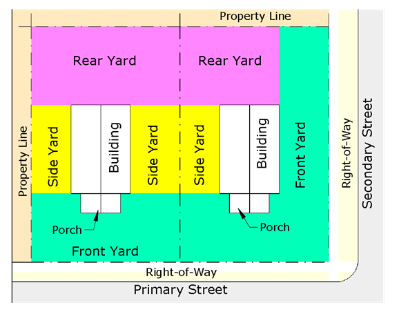
- Yard
An open space that lies between the principal building or buildings and the nearest lot line (Fig. 4.6-2).
Fig. 4.6-2- Front Yard
A space extending the full width of the lot between the principal building and the front lot line. On corner lots, any side adjacent to the street shall be considered a front yard. - Rear Yard
A space extending the full width of the lot between the principal building and the rear lot line. - Side Yard
A space extending from the front yard to the rear yard between the principal building and the side lot line.
- Front Yard
4.6.3 Density
- Single-dwelling unit residential density is expressed in units per acre and is calculated by dividing the total number of dwelling units by the gross site area.
- Multi-dwelling unit residential density can also be expressed as bedrooms per acre and is calculated by dividing the total number of bedrooms by the gross site area.
- Although minimum lot sizes may allow for additional units, density serves as the maximum number of units per acre. In multi-dwelling unit residential districts, the maximum bedroom density shall control density.
4.6.4 Building Setbacks
Figure 4.6-3
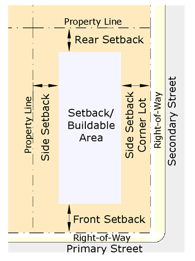
- Setback Types
There are eight (8) types of setback – front setback, front setback maximum, front setback minimum, side setback, side setback adjacent to detached residential, side setback for a corner lot, rear setback, and rear setback adjacent to street or alley. - Building Types for setback
There are four (4) building types for setback- principal building, secondary building, accessory dwelling, and accessory structure.
4.6.5 Additional Setback Requirements For Public Frontage
The area between the face of the curb and the back of the sidewalk (Fig. 4.6-4 & Fig 4.6.5).
Fig. 4.6-4

Fig. 4.6-5

4.6.6 Measurement Of Building Setbacks
- Front setbacks and side setbacks for corner lots are measured perpendicular from the edge of the existing or proposed right-of-way.
- Side setbacks are measured perpendicular from the side property line.
- Rear setbacks are measured perpendicular from the rear property line or the edge of the existing or proposed right-of-way.
4.6.7 Setback Encroachments
All buildings and structures must be located at or behind required setbacks, except as listed below. Underground structures covered by the ground may encroach into a required setback.
- Building Features
- Building eaves, roof overhangs, and awnings may encroach any setback up to three (3) feet as long as a minimum distance of ten (10) feet of horizontal separation from any part of an existing or proposed neighboring structure is maintained.
- Stoops and steps serving the primary entrance to the building may encroach into a required setback, provided that no part of the steps or handrails extend into the right-of-way or required sidewalk.
- Chimneys or flues may encroach any side and rear setback horizontally up to four (4) feet, provided that such extensions are at least three (3) feet from the vertical plane of any lot line.
- In T-5D, T-5C, and T5-U zoning districts, stoops, lightwells, terraces, awnings, arcades, balconies, and galleries may encroach the front setback one hundred (100) percent with a minimum vertical clearance of eight (8) feet. All encroachments within the right-of-way shall be approved by the Board of Aldermen.
- In TN-N, TND, and T-4 zoning districts, stoops, lightwells, terraces, and awnings may encroach the front setback fifty (50) percent with a minimum vertical clearance of eight (8) feet.
- Ramps providing ADA access may encroach any side setback. Ramps shall not encroach front setbacks in form-based districts.
- Mechanical Equipment and Utility Lines
- Mechanical equipment associated with residential uses, such as HVAC units and security lighting, may encroach into a required rear or side setback.
- Rainwater collection or harvesting systems may encroach into a required rear or side setback.
- Utility lines located underground and minor structures accessory to utility lines (such as hydrants, manholes and transformers and other cabinet structures) may encroach into any required setback.
- Other Setback Encroachments
- Fences and walls may encroach into any side setback subject to the requirements in the Use Regulations and Development Standards section.
- Signs may encroach into any front or side building setback subject to the requirements in the Use Regulations and Development Standards section.
4.6.8 Lot Frontage Buildout
The required percentage of lot width that must be occupied by a building facade between the minimum and maximum setback range adjacent to street. Lot frontage shall only apply to form-based districts. The following may be calculated as part of the lot frontage buildout at the discretion of the City Planner: courtyard, porch, common yard constituting a public plaza, and/or terrace providing outdoor dining as well as public circulation (Fig. 4.6-6).
Fig. 4.6-6

4.6.9 Building Height And Mass
- Building Height
- Building height is measured from average grade at the front line of the building in both number of stories and feet to the top of the highest point of a pitched or flat roof, not including a maximum parapet wall encroachment (Fig. 4.6-7).
Fig. 4.6-7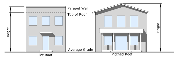
- Average grade is determined by calculating the average of the highest and lowest elevation along pre-development grade or improved grade (whichever is more restrictive) along the front of the building parallel to the primary street setback. Where mass-grading has been approved by the City, average grade shall be considered the improved grade following such mass grading (Fig. 4.6-8).
Fig. 4.6-8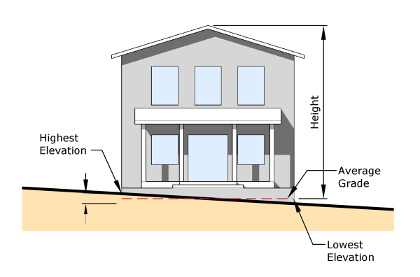
- Where the property slopes downward from the front property line, one (1) additional story above the maximum number of stories may be built on the lower rear portion of the lot below the finish grade at the front facing wall (Fig. 4.6-9).
Fig. 4.6-9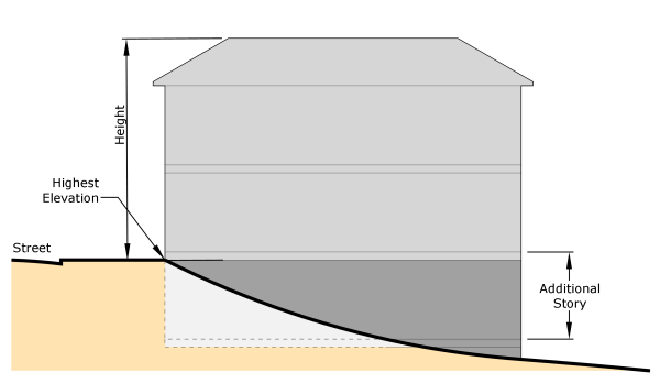
- Where the property slope increases from the front to the rear, building height is measured from the average point at grade of the front and rear wall plane (Fig. 4.6-10).
Fig. 4.6-10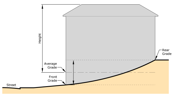
- An attic is a space not intended for human occupancy and does not count as a story where forty percent (40%) or more of the attic floor area has a clear height of less than five (5) feet; measured from the finished floor to the finished ceiling.
Fig. 4.6-11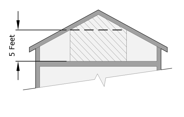
- A half story is a space intended for human occupancy that is situated within a sloping roof that may have dormer windows with a minimum clear interior height of seven (7) feet that is accessed internally from the principal structure.
- A basement with fifty percent (50%) or more of its perimeter wall area (measured from finished floor elevation) that is surrounded by finished grade is not considered a story.
- Building height is measured from average grade at the front line of the building in both number of stories and feet to the top of the highest point of a pitched or flat roof, not including a maximum parapet wall encroachment (Fig. 4.6-7).
- Ground Floor Elevation
Ground floor elevation is measured from the average curb level of the adjoining street, or if no curb exists, the average level of the center crown of the street to the top of the finished ground floor.
Fig. 4.6-12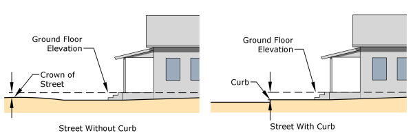
- Story Height
- Story height is measured from the top of the finished floor to top of the finished floor above or highest point of a pitched or flat roof, not including a maximum parapet wall encroachment.
- Minimum ground story height applies to the first thirty (30) feet of the building measured inward from the street facing facade. At least fifty percent (50%) of the ground story must meet the minimum ground story height provisions.
Fig. 4.6-13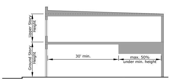
- Height Encroachments
Any height encroachment not specifically listed is expressly prohibited except where the City Planner determines that the encroachment is similar to a permitted encroachment listed below.- The maximum height limits of the district do not apply to spires, belfries, and cupolas attached to buildings. Freestanding water tanks, telecommunication towers, and accessory structures associated with industrial uses may exceed the established height limits of the district.
- The maximum height encroachment for a parapet wall is four (4) feet unless more is required for screening mechanical equipment located on the roof from view from the right-of-way.
- The following accessory structures may exceed the established height limits for a building with a flat roof, provided they do not exceed the existing or proposed building height by more than twelve (12) feet and do not occupy more than twenty-five percent (25%) of the roof area:
- Chimney, flue, or vent stack
- Rooftop garden, patio, or seating area
- Flagpole
- Elevator or stairway access to roof
- Rainwater collection or harvesting system
- Greenhouse
- Telecommunication facilities attached to a building
- The following accessory structures may exceed the established height limits for a building with a sloped roof, provided they do not exceed the existing or proposed building height by more than eight (8) feet and do not occupy more than twenty-five percent (25%) of the roof area:
- Chimney, flue, or vent stack
- Flagpole
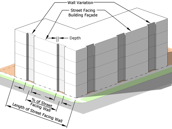
- Articulation in Building Façade
Fig. 4.6-14- Required length of wall variations (recessed or projected) of street facing building facades shall be calculated by a percentage of the length of the street facing wall of a building unless otherwise specifically stated in the development standards for that zoning district.
- The depth of the wall variation shall be measured from the face of the street facing building facade.
4.6.10 Transparency
The transparency requirements are intended to lend visual interest to street facing building facades for both pedestrians and building occupants by minimizing blank wall areas. The transparency requirements also provide safety for both pedestrians and building occupants by increasing visibility into and out of buildings.
Fig. 4.6-15
- The transparency requirements shall be calculated as a percentage of windows and doors on a facade face of a story. The top story shall be calculated from finished floor of top story to the top of the wall plate of the top story.
- Doors shall have a minimum of seventy percent (70%) glass to be included in the transparency calculation.
- Window area shall be calculated from the outside frame of the window. Mullions shall be included in the window area calculation.
- The window area on the ground floor for commercial use shall only be included in the required transparency percentage calculation if the glass is considered transparent.
- Glass shall be considered transparent if the transparency is higher than eighty percent (80%) and the external reflectance is less than fifteen percent (15%).
- Vinyl window graphics, either perforated or frosted, shall not be considered transparent and shall be considered a window sign.
4.6.11 Parking Setbacks
The minimum or maximum distance between a parking lot and any lot line or right-of-way.
Fig. 4.6-16
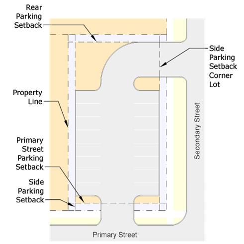
- Parking Setback Types
There are four (4) types of parking setbacks- primary street setback, side street setback, side setback, and rear setback. - Measurement of Parking Setbacks
- Primary and side street setbacks are measured perpendicular from the edge of the existing or proposed right-of-way to the back of curb or edge of pavement of the parking area, whichever is greater.
- Side setbacks are measured perpendicular from the side property line to the back of curb or edge of pavement of the parking area, whichever is greater.
- Rear setbacks are measured perpendicular from the rear property line or the edge of the existing or proposed right-of-way to the back of curb or edge of pavement of the parking area, whichever is greater.
- Parking Not Allowed
On-site surface parking must be located behind the parking setback line. Parking decks must adhere to the building setback requirements. This requirement does not apply to on-street public parking.
4.6.12 Visibility At Intersections
- Obstructions to visibility between height of two and a half (2 ½) feet and eight (8) feet measured vertically from the centerline of the street shall not be placed or allowed to remain if determined unsafe by the City Engineer in any required sight triangle. Obstructions shall include landscaping, fencing, walls, finished grade, buildings, or other structures.
Fig. 4.6-17
- Street intersections shall maintain a sight triangle of thirty feet by thirty feet (30’ x 30’) bounded on two (2) sides by the edge of pavement or face of curb of the streets and on the third (3) side by a straight line connecting the endpoints of the other two (2) sides. Where crosswalks are provided, the edge of the crosswalk furthest from the intersection shall be used as a side in place of edge of pavement or curb.
Fig. 4.6-18
- Driveway intersections shall maintain a sight triangle of fifteen feet by fifteen feet (15’ x15’) bounded on two (2) sides by the edge of pavement or face of curb of the streets and on the third (3) side by a straight line connecting the end points of the other two (2) sides. In the event that a driveway crosses a sidewalk, then the edge of sidewalk furthest from the street shall be used as a side in place of edge of pavement or curb.