
Walterboro City Zoning Code
CHAPTER 6
- ENVIRONMENTAL PROTECTION & OPEN SPACE
Section 6.1 - Purpose
The purpose of this Chapter is:
• To protect existing environmental resources including streams, wetlands, floodplains, soils, forest stands, specimen trees and other significant vegetation and wildlife.
• To protect life and property
• To promote the preservation of open space in environmentally sensitive areas
• To provide recreational amenities for the residents of the City.
Section 6.2 - Environmental Assessment & Existing Features Plan
A.
Existing Features Plans are required for the Sketch Plan step of all subdivisions of greater than five (5) lots and with Site Plan applications for developments of greater than one (1) acre and shall be submitted in accordance with Section 12.2. This plan shall include soils, topography, ecology, drainage, past uses, adjacent uses, and existing vegetation, structures, roads, and utilities. See Fig. 6.1 on following page.
B.
Site design shall take the Existing Features Plan into consideration with regard to existing and adjacent land uses, the City of Walterboro Comprehensive Plan, and other plans. The design shall provide adequate internal access and safe and suitable external access that is well integrated with existing roads, prevent adverse impacts to adjacent land uses, provide adequate usable open space and connections to existing parks and recreational activities as possible, and assure compatibility with the City's future growth plans. See Fig. 6.1 on following page.
C.
Natural features of the site shall be preserved and impacts to sensitive environmental areas minimized to the extent practicable when designing the development. The design shall also avoid impacts to ground water and aquifer recharge by avoiding clear cutting, reducing impervious cover, and other activities. The following natural features and resources shall be identified:
1.
watercourses
2.
wetlands
3.
unique natural areas
4.
floodplains and floodways
5.
endangered species habitats
6.
historic structures
7.
any flowering tree two (2) inches in diameter at breast height (DBH) or larger and all other trees of 10 inches DBH or larger
8.
large stands of trees
9.
viewsheds
10.
steep slopes
FIG. 6.1: EXAMPLE EXISTING FEATURES PLAN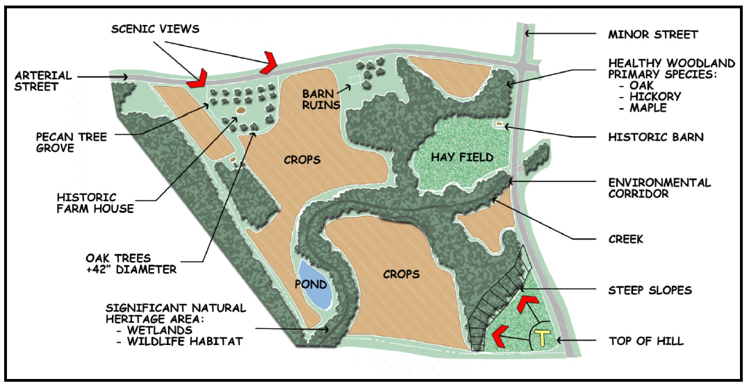
Section 6.4 - Stream & Wetlands Buffers
Buffers shall be established on all perennial streams and wetlands. The buffer shall be located a minimum of 40 feet from each side of the stream bed or wetland delineation. Buffers shall remain undisturbed except that narrow pervious walking paths may be utilized as part of the open space for a development.
FIG. 6.4: STREAM BUFFER PROTECTION
Section 6.5 - Flood Damage Control[1]
Editor's note— Ord. No. 2017-10 , adopted November 14, 2017, repealed the former Section 6.5, §§ 6.5.1—6.5.17, and enacted a new Section 6.5 as set out herein. The former Section 6.5 pertained to similar subject matter and derived from Ord. No. 2015-01 , 3-24-15.
6.3.1 - Applicability
A.
This Section shall apply to all protected trees located within rights-of-way, parks, public places, and private property located within the corporate limits of the City of Walterboro as amended. Protected tree shall mean any flowering tree two (2) inches in diameter at breast height (DBH) or larger and all other trees of 10 inches DBH or larger. See Fig. 6.2 on the following page.
B.
Utility companies, electric suppliers and governmental agencies in the course of constructing or maintaining easements for water, sewer, electricity, gas, drainage, telephone or television transmission or rights-of-way shall only be exempt from the provisions of this Section if the applicable company, supplier or agency has executed an agreement with the city which, at a minimum: recognizes the need to minimize trimming of protected grand trees which do not substantially interfere with the intended purposes of construction and maintenance; follows ISA Best Management Practices for utility pruning; identifies the saving of grand trees as a factor to be considered in the design process; and allows for a consultation process with the city prior to the commencement of major construction or maintenance or the removal of grand trees. A breach of such agreement constitutes a violation of this Section and a loss of the exemption provided for herein.
6.3.2 - Tree Removal & Protection
A.
It shall be unlawful for any person to fell, injure or destroy any living or dead protected tree within the corporate limits of the City of Walterboro, except with approval of a Tree Permit as provided for in Section 11.6.
B.
Reasonable measures must be taken during construction or development and shown on a tree protection and site mobilization plan to protect remaining trees from damage or injury in the following ways:
1.
Prior to any construction, tree protective barriers (such as silt fencing or orange safety fencing) shall be placed around all landscaping to be saved or around root protection area(s), to prevent damage to existing landscaping (See Fig. 6.3). These barricades shall be installed prior to grading, construction, or other land disturbing activity, and cannot be constructed from any material not substantial enough to protect the roots, trunks, and crown of the tree. The barricade standards or rails shall be placed a minimum distance of six (6) feet from the edge of the trunk and no less than the dripline of the tree.
2.
No soil disturbance or compaction, stock piling of soil or other construction materials, vehicular traffic, storage of heavy equipment are allowed in the tree and root protection area, or within the dripline of trees to be retained.
3.
Paving of area within an existing tree's dripline is strongly discouraged.
4.
Root pruning should be kept to an absolute minimum.
5.
No ropes, signs, wires, unprotected electrical installation or other device or material, shall be secured or fastened around or through a tree or shrub.
6.
Unprotected electrical service wires should not be allowed to come into contact with any tree.
FIG. 6.2 TREE MEASUREMENT TERMS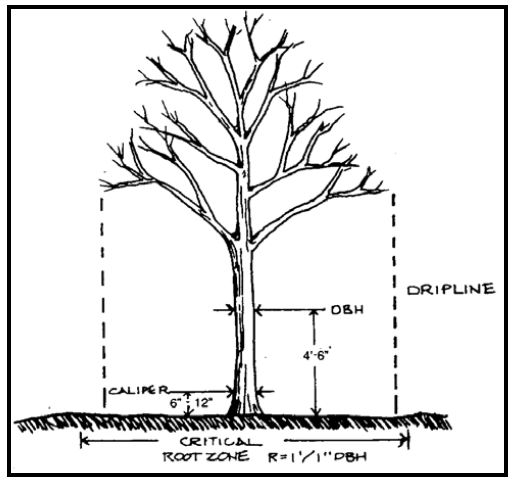
FIG. 6.3 TREE PROTECTION DETAIL
6.3.3 - Mitigation
A.
The removal of any protected tree authorized by permit shall be mitigated by planting new trees from the South Carolina Urban Species Guide. The replacement trees shall have a minimum two (2) inch DBH; provided, however, for protected flowering trees replacement flowering trees of one (1) inch DBH minimum are acceptable. The number of trees required shall have a total DBH equal twenty-five (25) percent of the total diameter of the trees requiring mitigation, except for grand trees which shall require a minimum of 12 inches DBH of mitigation per grand tree. A grand tree shall mean any tree of 24 inches DBH or larger.
B.
All mitigation shall be carried out on the site from which the trees were removed, unless otherwise approved by the Tree Committee.
C.
The removal of any protected tree authorized by permit on lots containing owner-occupied single-family dwellings may be exempt from mitigation on a case-by-case basis as determined by the Tree Committee. The Tree Committee will take into account the reason(s) for the removal, impact on the tree population density of the neighborhood and the lot configuration, financial hardship for the property owner, and any other pertinent factors in its mitigation recommendation. In no circumstances will mitigation exceed the parameters outlined in Subsection (A).
D.
In lieu of on-site mitigation, the property owner or developer may elect to contribute the amount specified on the adopted Comprehensive Fee Schedule times the total diameter in inches of the required mitigation trees. The funds generated by this mitigation provision shall be deposited in the City Tree Fund.
E.
Protected trees removed without a permit shall be mitigated at a rate of 100 percent of the diameter of the protected trees removed, unless otherwise approved by the Tree Committee. Illegally removed trees shall be mitigated on site unless otherwise approved by the Tree Committee.
F.
All trees planted as mitigation shall be properly maintained for a minimum period of 24 months after planting. Any trees which fail to survive for 24 months shall be replaced during this period, and all replacement mitigation tree(s) shall be properly maintained and replaced as required of mitigation trees by this subsection.
G.
Trees removed because they are dead do not require mitigation if the loss of the tree is of no fault of the owner/resident or any other person in order to circumvent the purpose of this ordinance.
H.
The removal of pine trees by permit does not require mitigation, unless multiple trees are removed so as to constitute clear-cutting. The mitigation for the permitted clear-cutting of pine trees may be reduced or exempted on a case-by-case basis as determined by the Tree Committee. The Tree Committee will take into account the reason(s) for the removal, impact on the tree population density of the neighborhood and the lot configuration, financial hardship for the property owner, and any other pertinent factors in its mitigation recommendation. In no circumstances will mitigation exceed the parameters outlined in this Subsection (A).
I.
Trees identified by the South Carolina Exotic Pest Plant Council Non-Native Plant Species List do not require mitigation.
6.3.4 - Administration
A.
The Administrator and/or other designee(s) of the City Manager shall administer this Section and shall consult with the City Manager, the City Parks Director and persons knowledgeable about trees as needed.
B.
During the period of an emergency, such as during the recovery period following a tornado, hurricane, ice storm, flood or any other act of nature or disaster, the requirements of this Section may be waived by the City Manager for a period not to exceed thirty (30) days. The waiver period may be extended for a longer period by the action of City Council. In such cases, the waiver shall apply only to felled or severely damaged trees which pose a safety hazard.
6.5.1 - Statutory Authorization
The Legislature of the State of South Carolina has in SC Code of Laws, Title 5 and Title 6, and amendments thereto, delegated the responsibility to local governmental units to adopt regulations designed to promote the public health, safety, and general welfare of its citizenry.
(Ord. No. 2017-10 , 11-14-17)
6.5.2 - Findings of Fact
The Special Flood Hazard Areas of the City of Walterboro are subject to periodic inundation which results in loss of life, property, health and safety hazards, disruption of commerce and governmental services, extraordinary public expenditures of flood protection and relief, and impairment of the tax base, all of which adversely affect the public health, safety, and general welfare.
Furthermore, these flood losses are caused by the cumulative effect of obstructions in floodplains causing increases in flood heights and velocities, and by the occupancy in flood hazard areas by uses vulnerable to floods or hazardous to other lands which are inadequately elevated, floodproofed, or otherwise unprotected from flood damages.
(Ord. No. 2017-10 , 11-14-17)
6.5.3 - Statement of Purpose
It is the purpose of this Section to protect human life and health, minimize property damage, and encourage appropriate construction practices to minimize public and private losses due to flood conditions by requiring that uses vulnerable to floods, including facilities which serve such uses, be protected against flood damage at the time of initial construction. Uses of the floodplain which are dangerous to health, safety, and property due to water or erosion hazards, or which increase flood heights, velocities, or erosion are restricted or prohibited. These provisions attempt to control the alteration of natural floodplains, stream channels, and natural protective barriers which are involved in the accommodation of flood waters, and control filling, grading, dredging and other development which may increase flood damage or erosion. Additionally, the ordinance prevents or regulates the construction of flood barriers which will unnaturally divert floodwaters or which may increase flood hazards to other lands.
The objectives of this Section are to protect human life and health, to help maintain a stable tax base by providing for the sound use and development of flood-prone areas in such a manner as to minimize flood blight areas, and to insure that potential home buyers are notified that property is in a flood area. The provisions of the ordinance are intended to minimize damage to public facilities and utilities such as water and gas mains, electric, telephone, and sewer lines, streets and bridges located in the floodplain, and prolonged business interruptions. Also, an important floodplain management objective of this ordinance is to minimize expenditure of public money for costly flood control projects and rescue and relief efforts associated with flooding.
Floodplains are an important asset to the community. They perform vital natural functions such as temporary storage of floodwaters, moderation of peak flood flows, maintenance of water quality, groundwater recharge, prevention of erosion, habitat for diverse natural wildlife populations, recreational opportunities, and aesthetic quality. These functions are best served if floodplains are kept in their natural state. Wherever possible, the natural characteristics of floodplains and their associated wetlands and water bodies should be preserved and enhanced. Decisions to alter floodplains, especially floodways and stream channels, should be the result of careful planning processes that evaluate resource conditions and human needs.
(Ord. No. 2017-10 , 11-14-17)
6.5.4 - Applicability of Section
This Section shall apply to all areas of special flood hazard within the jurisdiction of the City of Walterboro as identified by the Federal Emergency Management Agency (FEMA) in its Flood Insurance Study, dated December 21, 2017, with accompanying maps and other supporting data that are hereby adopted by reference and declared to be a part of this ordinance.
Upon annexation any special flood hazard areas identified by the Federal Emergency Management Agency (FEMA) in its Flood Insurance Study for the unincorporated areas of Colleton County, with accompanying map and other data are adopted by reference and declared part of this ordinance.
(Ord. No. 2017-10 , 11-14-17)
6.5.5 - Establishment of Development Permit
A Development Permit shall be required in conformance with the provisions of this ordinance prior to the commencement of any development activities.
(Ord. No. 2017-10 , 11-14-17)
6.5.6 - Compliance
No structure or land shall hereafter be located, extended, converted, or structurally altered without full compliance with the terms of this ordinance and other applicable regulations.
(Ord. No. 2017-10 , 11-14-17)
6.5.7 - Interpretation
In the interpretation and application of this Section all provisions shall be considered as minimum requirements, liberally construed in favor of the governing body, and deemed neither to limit nor repeal any other powers granted under State law. This ordinance is not intended to repeal, abrogate, or impair any existing easements, covenants, or deed restrictions. However, where this ordinance and another conflict or overlap, whichever imposes the more stringent restrictions, shall prevail.
(Ord. No. 2017-10 , 11-14-17)
6.5.8 - Partial Invalidity and Severability
If any part of this Section is declared invalid, the remainder of the Section shall not be affected and shall remain in force.
(Ord. No. 2017-10 , 11-14-17)
6.5.9 - Warning and Disclaimer of Liability
The degree of flood protection required by this ordinance is considered reasonable for regulatory purposes and is based on scientific and engineering consideration. Larger floods can and will occur on rare occasions. Flood heights may be increased by man-made or natural causes. This ordinance does not imply that land outside the areas of special flood hazard or uses permitted within such areas will be free from flooding or flood damages. This ordinance shall not create liability on the part of the City of Walterboro or by any officer or employee thereof for any flood damages that result from reliance on this ordinance or any administrative decision lawfully made hereunder.
(Ord. No. 2017-10 , 11-14-17)
6.5.10 - Penalties for Violation
Violation of the provisions of this ordinance or failure to comply with any of its requirements, including violation of conditions and safeguards established in connection with grants of variance or special exceptions, shall constitute a misdemeanor. Any person who violates this ordinance or fails to comply with any of its requirements shall, upon conviction thereof, be fined not more than $500.00 or imprisoned for not more than 30 days, or both. Each day the violation continues shall be considered a separate offense. Nothing herein contained shall prevent the City of Walterboro from taking such other lawful action as is necessary to prevent or remedy any violation.
(Ord. No. 2017-10 , 11-14-17)
6.5.11 - Definitions (See also Appendix A - Flood Control Definitions).
Unless specifically defined below, words or phrases used in this Ordinance shall be interpreted so as to give them the meaning they have in common usage and to give this ordinance it's most reasonable application.
Accessory structure (appurtenant structure). Structures that are located on the same parcel of property as the principal structure and the use of which is incidental to the use of the principal structure. Accessory Structures should constitute a minimal investment, may not be used for human habitation, and be designed to have minimal flood damage potential. Examples of accessory structures are detached garages, carports, storage sheds, pole barns, and hay sheds.
Addition (to an existing building). An extension or increase in the floor area or height of a building or structure. Additions to existing buildings shall comply with the requirements for new construction regardless as to whether the addition is a substantial improvement or not. Where a firewall or load-bearing wall is provided between the addition and the existing building, the addition(s) shall be considered a separate building and must comply with the standards for new construction.
Agricultural structure. A structure used solely for agricultural purposes in which the use is exclusively in connection with the production, harvesting, storage, drying, or raising of agricultural commodities, including the raising of livestock. Agricultural structures are not exempt from the provisions of this ordinance.
Appeal. A request for a review of the local floodplain administrator's interpretation of any provision of this ordinance.
Area of shallow flooding. A designated AO or VO Zone on a community's Flood Insurance Rate Map (FIRM) with base flood depths of one to three feet where a clearly defined channel does not exist, where the path of flooding is unpredictable and indeterminate, and where velocity flow may be evident.
Area of special flood hazard. The land in the floodplain within a community subject to a one percent or greater chance of being equaled or exceeded in any given year.
Base flood. The flood having a one percent chance of being equaled or exceeded in any given year.
Basement means any enclosed area of a building that is below grade on all sides.
Building. See "structure".
Critical development. Development that is critical to the community's public health and safety, is essential to the orderly functioning of a community, store or produce highly volatile, toxic or water-reactive materials, or house occupants that may be insufficiently mobile to avoid loss of life or injury. Examples of critical development include jails, hospitals, schools, fire stations, nursing homes, wastewater treatment facilities, water plants, and gas/oil/propane storage facilities.
Development. Any man-made change to improved or unimproved real estate, including, but not limited to, buildings or other structures, mining, dredging, filling, grading, paving, excavation or drilling operations, or storage of equipment or materials.
Elevated building. A non-basement building built to have the lowest floor elevated above the ground level by means of solid foundation perimeter walls, pilings, columns, piers, or shear walls parallel to the flow of water.
Executive Order 11988 (Floodplain Management). Issued by President Carter in 1977, this order requires that no federally assisted activities be conducted in or have the potential to affect identified special flood hazard areas, unless there is no practicable alternative.
Existing construction means, for the purposes of determining rates, structures for which the start of construction commenced before June 7, 1974.
Existing manufactured home park or manufactured home subdivision. A manufactured home park or subdivision for which the construction of facilities for servicing the lots on which the manufactured homes are to be affixed (including, at a minimum, the installation of utilities, the construction of streets, and either final site grading or the pouring of concrete pads) is completed before April 17, 1987.
Expansion to an existing manufactured home park or subdivision. The preparation of additional sites by the construction of facilities for servicing the lots on which the manufactured homes are to be affixed (including the installation of utilities, the construction of streets, and either final site grading or the pouring of concrete slabs).
Flood. A general and temporary condition of partial or complete inundation of normally dry land areas from the overflow of inland or tidal waters, or the unusual and rapid accumulation of runoff of surface waters from any source.
Flood Hazard Boundary Map (FHBM). An official map of a community, issued by the Federal Emergency Management Agency, where the boundaries of the areas of special flood hazard have been defined as Zone A.
Flood Insurance Rate Map (FIRM). An official map of a community, on which the Federal Emergency Management Agency has delineated both the areas of special flood hazard and the risk premium zones applicable to the community.
Flood Insurance Study. The official report provided by the Federal Emergency Management Agency which contains flood profiles, as well as the Flood Boundary Floodway Map and the water surface elevation of the base flood.
Flood-resistant material. Any building material capable of withstanding direct and prolonged contact (minimum 72 hours) with floodwaters without sustaining damage that requires more than low-cost cosmetic repair. Any material that is water-soluble or is not resistant to alkali or acid in water, including normal adhesives for above-grade use, is not flood-resistant. Pressure-treated lumber or naturally decay-resistant lumbers are acceptable flooring materials. Sheet-type flooring coverings that restrict evaporation from below and materials that are impervious, but dimensionally unstable are not acceptable. Materials that absorb or retain water excessively after submergence are not flood-resistant. Please refer to Technical Bulletin 2, Flood Damage-Resistant Materials Requirements, dated 8/08, and available from the Federal Emergency Management Agency. Class 4 and 5 materials, referenced therein, are acceptable flood-resistant materials.
Floodway. The channel of a river or other watercourse and the adjacent land areas that must be reserved in order to discharge the base flood without cumulatively increasing the water surface elevation more than one foot.
Freeboard. A factor of safety usually expressed in feet above a flood level for purposes of flood plain management. "Freeboard" tends to compensate for the many unknown factors that could contribute to flood heights greater than the height calculated for a selected size flood and floodway conditions, such as wave action, bridge openings, and the hydrological effect of urbanization of the watershed.
Functionally dependent use. A use which cannot perform its intended purpose unless it is located or carried out in close proximity to water. The term includes only docking facilities, port facilities that are necessary for the loading and unloading of cargo or passengers, and ship building and ship repair facilities, but does not include long-term storage or related manufacturing facilities.
Highest adjacent grade. The highest natural elevation of the ground surface, prior to construction, next to the proposed walls of the structure.
Historic structure. Any structure that is: (a) listed individually in the National Register of Historic Places (a listing maintained by the U.S. Department of the Interior (DOI)) or preliminarily determined by the Secretary of the Interior as meeting the requirements for individual listing on the National Register; (b) certified or preliminarily determined by the Secretary of the Interior as contributing to the historical significance of a registered historic district or a district preliminarily determined by the Secretary to qualify as a registered historic district; (c) individually listed on a State inventory of historic places; (d) individually listed on a local inventory of historic places in communities with historic preservation programs that have been certified (1) by an approved State program as determined by the Secretary of Interior, or (2) directly by the Secretary of Interior in states without approved programs. Some structures or districts listed on the State or local inventories MAY NOT be "Historic" as cited above, but have been included on the inventories because it was believed that the structures or districts have the potential for meeting the "Historic" structure criteria of the DOI. In order for these structures to meet NFIP historic structure criteria, it must be demonstrated and evidenced that the South Carolina Department of Archives and History has individually determined that the structure or district meets DOI historic structure criteria.
Increased cost of compliance (ICC). Applies to all new and renewed flood insurance policies effective on and after June 1, 1997. The NFIP shall enable the purchase of insurance to cover the cost of compliance with land use and control measures established under Section 1361. It provides coverage for the payment of a claim to help pay for the cost to comply with State or community floodplain management laws or ordinances after a flood event in which a building has been declared substantially or repetitively damaged.
Limited storage. An area used for storage and intended to be limited to incidental items that can withstand exposure to the elements and have low flood damage potential. Such an area must be of flood resistant or breakaway material, void of utilities except for essential lighting and cannot be temperature controlled. If the area is located below the base flood elevation in an A, AE and A1-A30 zone it must meet the requirements of Section 6.5.16.A.4 of this ordinance.
Lowest Adjacent Grade (LAG). Is an elevation of the lowest ground surface that touches any deck support, exterior walls of a building or proposed building walls.
Lowest Floor. The lowest floor of the lowest enclosed area (including basement). An unfinished or flood resistant enclosure, usable solely for parking of vehicles, building access or storage in an area other than a basement area is not considered a building's lowest floor; provided, that such enclosure is not built so as to render the structure in violation of the applicable non-elevation design requirements of this Ordinance.
Manufactured home. A structure, transportable in one or more sections, which is built on a permanent chassis and designed to be used with or without a permanent foundation when connected to the required utilities. The term "manufactured home" does not include a "recreational vehicle".
Manufactured Home Park or subdivision. A parcel (or contiguous parcels) of land divided into two or more manufactured home lots for rent or sale.
Mean Sea Level means, for the purpose of this Ordinance, the Nations Geodetic Vertical Datum (NGVD) of 1929, North American Vertical Datum (NAVD) of 1988, or other datum, to which the base flood elevations shown on a community's Flood Insurance Rate Maps (FIRM) are shown.
National Geodetic Vertical Datum (NGVD) of 1929. As corrected in 1929, elevation reference points set by National Geodetic Survey based on mean sea level.
North American Vertical Datum (NAVD) of 1988. Vertical control, as corrected in 1988, used as the reference datum on Flood Insurance Rate Maps.
New construction. Structure for which the start of construction commenced on or after April 17, 1987. The term also includes any subsequent improvements to such structure.
New manufactured home park or subdivision. A manufactured home park or subdivision for which the construction of facilities for servicing the lots on which the manufactured homes are to be affixed (including at a minimum, the installation of utilities, the construction of streets, and either final site grading or the pouring of concrete slabs) is completed on or after April 17, 1987.
Recreational vehicle. A vehicle which is: (a) built on a single chassis; (b) 400 square feet or less when measured at the largest horizontal projection; (c) designed to be self-propelled or permanently towable by a light duty truck; and, (d) designed primarily not for use as a permanent dwelling, but as temporary living quarters for recreational, camping, travel, or seasonal use.
Repetitive Loss. A building covered by a contract for flood insurance that has incurred flood-related damages on two occasions during a 10-year period ending on the date of the event for which a second claim is made, in which the cost of repairing the flood damage, on the average, equaled or exceeded 25 percent of the market value of the building at the time of each such flood event.
Section 1316 of the National Flood insurance Act of 1968. The act provides that no new flood insurance shall be provided for any property found by the Federal Emergency Management Agency to have been declared by a state or local authority to be in violation of state or local ordinances.
Stable Natural Vegetation. The first place on the oceanfront where plants such as sea oats hold sand in place.
Start of construction. For other than new construction or substantial improvements under the Coastal Barrier Resources Act (P.L. 97-348), includes substantial improvement, and means the date the building permit was issued, provided the actual start of construction, repair, reconstruction, rehabilitation, addition, or improvement was within 180 days of the permit date. The actual start means the first placement of permanent construction of a structure (including a manufactured home) on a site, such as the pouring of slabs or footings, installation of piles, construction of columns, or any work beyond the stage of excavation or the placement of a manufactured home on a foundation. Permanent construction does not include land preparation, such as clearing, grading, and filling; nor does it include the installation of streets and/or walkways; nor does it include excavation for footings, piers or foundations, or the erection of temporary forms; nor does it include the installation on the property of accessory buildings, such as garages or sheds not occupied as dwelling units or not part of the main structure. For a substantial improvement, the actual start of construction means the first alteration of any wall, ceiling, floor, or other structural part of the building, whether or not that alteration affects the external dimensions of the building.
Structure. A walled and roofed building, a manufactured home, including a gas or liquid storage tank that is principally above ground.
Substantial damage. Damage of any origin sustained by a structure whereby the cost of restoring the structure to it's before damaged condition would equal or exceed 50 percent of the market value of the structure before the damage occurred. Such repairs may be undertaken successively and their costs counted cumulatively. Please refer to the definition of "substantial improvement".
Substantial improvement. Any repair, reconstruction, rehabilitation, addition, or other improvement of a structure, the cost of which equals or exceeds 50 percent of the market value of the structure before the start of construction of the improvement. This term includes structures that have incurred repetitive loss or substantial damage, regardless of the actual repair work performed. The term does not, however, include either:
a)
Any project of improvement to a structure to correct existing violations of State or local health, sanitary, or safety code specifications which have been identified by the local code enforcement official and which are the minimum necessary to assure safe living conditions or,
b)
Any alteration of a historic structure, provided that the alteration will not preclude the structure's continued designation as a historic structure.
Permits shall be cumulative for a period of five years. If the improvement project is conducted in phases, the total of all costs associated with each phase, beginning with the issuance of the first permit, shall be utilized to determine whether "substantial improvement" will occur.
Substantially improved existing manufactured home park or subdivision. Where the repair, reconstruction, rehabilitation or improvement of the streets, utilities and pads equals or exceeds 50 percent of the value of the streets, utilities and pads before the repair, reconstruction, or improvement commenced.
Variance. Is a grant of relief from a term or terms of this Ordinance.
Violation. The failure of a structure or other development to be fully compliant with these regulations.
(Ord. No. 2017-10 , 11-14-17)
6.5.12 - Administration
A.
The Assistant City Manager is hereby appointed to administer and implement the provisions of this Ordinance.
B.
All LOMRs that are issued in the areas identified in Section 6.5.4 of this Ordinance are hereby adopted.
(Ord. No. 2017-10 , 11-14-17)
6.5.13 - Development Permit and Certification Requirements
A.
Development Permit. Application for a development permit shall be made to the local floodplain administrator on forms furnished by him or her prior to any development activities. The development permit may include, but not be limited to, plans in duplicate drawn to scale showing: the nature, location, dimensions, and elevations of the area in question; existing or proposed structures; and the location of fill materials, storage areas, and drainage facilities. Specifically, the following information is required:
1.
A plot plan that shows the 100-year floodplain contour or a statement that the entire lot is within the floodplain must be provided by the development permit applicant when the lot is within or appears to be within the floodplain as mapped by the Federal Emergency Management Agency or the floodplain identified pursuant to either the Duties and Responsibilities of the local floodplain administrator of Section 6.5.15.K or the Standards for Subdivision Proposals of Section 6.5.16.12.B and the Standards for streams without Estimated Base Flood Elevations and Floodways of Section 6.5.16.B.13. The plot plan must be prepared by or under the direct supervision of a registered land surveyor or professional engineer and certified by it. The plot plan must show the floodway, if any, as identified by the Federal Emergency Management Agency or the floodway identified pursuant to either the duties or responsibilities of the local floodplain administrator of Section 6.5.15.K or the standards for subdivision proposals of Section 6.5.16.B.12 and the standards for streams without estimated base flood elevations and floodways of Section 6.5.16.B.13.
2.
Where base flood elevation data is provided as set forth in Section 6.5.4 or the duties and responsibilities of the local floodplain administrator of Section 6.5.15.K the application for a development permit within the flood hazard area shall show:
(a)
The elevation (in relation to mean sea level) of the lowest floor of all new and substantially improved structures, and
(b)
If the structure will be floodproofed in accordance with the Non-Residential Construction requirements of Section 6.5.16.B.2 the elevation (in relation to mean sea level) to which the structure will be floodproofed.
(c)
Where base flood elevation data is not provided as set forth in Section 6.5.4 or the duties and responsibilities of the local floodplain administrator of Section 6.5.15.K, then the provisions in the standards for streams without estimated base flood elevations and floodways of Section 6.5.16.B.13 must be met.
(d)
Alteration of watercourse: Where any watercourse will be altered or relocated as a result of proposed development, the application for a development permit shall include a description of the extent of watercourse alteration or relocation, an engineering study to demonstrate that the flood-carrying capacity of the altered or relocated watercourse is maintained and a map showing the location of the proposed watercourse alteration or relocation.
B.
Certifications.
1.
Floodproofing Certification. When a structure is floodproofed, the applicant shall provide certification from a registered, professional engineer or architect that the non-residential, floodproofed structure meets the floodproofing criteria in the non-residential construction requirements of Section 6.5.16.B and Section 6.5.16.B.2.
2.
Certification During Construction - A lowest floor elevation or floodproofing certification is required after the lowest floor is completed. As soon as possible after completion of the lowest floor and before any further vertical construction commences, or floodproofing by whatever construction means, whichever is applicable, it shall be the duty of the permit holder to submit to the local floodplain administrator a certification of the elevation of the lowest floor, or floodproofed elevation, whichever is applicable, as built, in relation to mean sea level. Said certification shall be prepared by or under the direct supervision of a registered land surveyor or professional engineer and certified by it. Any work done prior to submission of the certification shall be at the permit holder's risk. The local floodplain administrator shall review the floor elevation survey data submitted. The permit holder immediately and prior to further progressive work being permitted to proceed shall correct deficiencies detected by such review. Failure to submit the survey or failure to make said corrections required hereby shall be cause to issue a stop-work order for the project.
3.
As-built Certification. Upon completion of the development a registered professional engineer, land surveyor or architect, in accordance with SC law, shall certify according to the requirements of Section 6.5.13.B that the development is built in accordance with the submitted plans and previous pre-development certifications.
(Ord. No. 2017-10 , 11-14-17)
6.5.14 - Duties and Responsibilities of the Local Floodplain Manager
A.
Permit Review. Review all development permits to assure that the requirements of this Ordinance have been satisfied.
B.
Requirement of Federal and/or state permits. Review proposed development to assure that all necessary permits have been received from those governmental agencies from which approval is required by Federal or State law, including section 404 of the Federal Water Pollution Control Act Amendments of 1972, 33 U.S.C 1334.
C.
Watercourse alterations -
1.
Notify adjacent communities and the South Carolina Department of Natural Resources, Land, Water, and Conservation Division, State Coordinator for the National Flood Insurance Program, prior to any alteration or relocation of a watercourse, and submit evidence of such notification to the Federal Emergency Management Agency.
2.
In addition to the notifications required watercourse alterations per Section 6.5.14, written reports of maintenance records must be maintained to show that maintenance has been provided within the altered or relocated portion of said watercourse so that the flood-carrying capacity is maintained. This maintenance must consist of a comprehensive program of periodic inspections, and routine channel clearing and dredging, or other related functions. The assurance shall consist of a description of maintenance activities, frequency of performance, and the local official responsible for maintenance performance. Records shall be kept on file for FEMA inspection.
3.
If the proposed project will modify the configuration of the watercourse, floodway, or base flood elevation for which a detailed Flood Insurance Study has been developed, the applicant shall apply for and must receive approval for a Conditional Letter of Map Revision with the Federal Emergency Management Agency prior to the start of construction.
4.
Within 60 days of completion of an alteration of a watercourse, referenced in the certification requirements of Section 6.5.13.B, the applicant shall submit as-built certification, by a registered professional engineer, to the Federal Emergency Management Agency.
D.
Floodway encroachments. Prevent encroachments within floodways unless the certification and flood hazard reduction provisions of Section 6.5.16.B.5 are met.
E.
Adjoining Floodplains. Cooperate with neighboring communities with respect to the management of adjoining floodplains and/or flood-related erosion areas in order to prevent aggravation of existing hazards.
F.
Notifying Adjacent Communities - Notify adjacent communities prior to permitting substantial commercial developments and large subdivisions to be undertaken in areas of special flood hazard and/or flood-related erosion hazards.
G.
Certification requirements -
1.
Obtain and review actual elevation (in relation to mean sea level) of the lowest floor of all new or substantially improved structures, in accordance with administrative procedures outlined in Section 6.5.13.B.
2.
Obtain the actual elevation (in relation to mean sea level) to which the new or substantially improved structures have been floodproofed, in accordance with the floodproofing certification outlined in Section 6.5.13.B.1.
3.
When floodproofing is utilized for a particular structure, obtain certifications from a registered professional engineer or architect in accordance with the non-residential construction requirements outlined in Section 6.5.16.B.2.
H.
Map Interpretation. Where interpretation is needed as to the exact location of boundaries of the areas of special flood hazard (for example, where there appears to be a conflict between a mapped boundary and actual field conditions), make the necessary interpretation. The person contesting the location of the boundary shall be given a reasonable opportunity to appeal the interpretation as provided in this section.
I.
Prevailing Authority - Where a map boundary showing an area of special flood hazard and field elevations disagree, the base flood elevations for flood protection elevations (as found on an elevation profile, floodway data table, etc.) shall prevail. The correct information should be submitted to FEMA as per the map maintenance activity requirements outlined in Section 6.5.16.B.7.b.
J.
Use Of Best Available Data. When base flood elevation data and floodway data has not been provided in accordance with Section 6.5.4, obtain, review, and reasonably utilize best available base flood elevation data and floodway data available from a federal, state, or other source, including data developed pursuant to the standards for subdivision proposals outlined in Section 6.5.16.B.12, in order to administer the provisions of this Ordinance. Data from preliminary, draft, and final Flood Insurance Studies constitutes best available data from a federal, state, or other source. Data must be developed using hydraulic models meeting the minimum requirement of NFIP approved model. If an appeal is pending on the study in accordance with 44 CFR Ch. 1, Part 67.5 and 67.6, the data does not have to be used.
K.
Special Flood hazard Area/topographic Boundaries Conflict. When the exact location of boundaries of the areas special flood hazards conflict with the current, natural topography information at the site; the site information takes precedence when the lowest adjacent grade is at or above the BFE, the property owner may apply and be approved for a Letter of Map Amendment (LOMA) by FEMA. The local floodplain administrator in the permit file will maintain a copy of the Letter of Map Amendment issued from FEMA.
L.
On-Site inspections. Make on-site inspections of projects in accordance with the administrative procedures outlined in Section 6.5.15.A
M.
Administrative Notices. Serve notices of violations, issue stop-work orders, revoke permits and take corrective actions in accordance with the administrative procedures in Section 6.5.15.
N.
Records Maintenance. Maintain all records pertaining to the administration of this Ordinance and make these records available for public inspection.
O.
Annexations and Detachments. Notify the South Carolina Department of Natural Resources Land, Water and Conservation Division, State Coordinator for the National Flood Insurance Program within six (6) months, of any annexations or detachments that include special flood hazard areas.
P.
Federally Funded Development. The President issued Executive Order 11988, Floodplain Management May 1977 . E.O. 11988 directs federal agencies to assert a leadership role in reducing flood losses and losses to environmental values served by floodplains. Proposed developments must go through an eight-step review process. Evidence of compliance with the executive order must be submitted as part of the permit review process.
Q.
Substantial Damage Determination - Perform an assessment of damage from any origin to the structure using FEMA's Residential Substantial Damage Estimator (RSDE) software to determine if the damage equals or exceeds 50 percent of the market value of the structure before the damage occurred.
R.
Substantial Improvement Determinations - Perform an assessment of permit applications for improvements or repairs to be made to a building or structure that equals or exceeds 50 percent of the market value of the structure before the start of construction. Cost of work counted for determining if and when substantial improvement to a structure occurs shall be cumulative for a period of five years. If the improvement project is conducted in phases, the total of all costs associated with each phase, beginning with the issuance of the first permit, shall be utilized to determine whether "substantial improvement" will occur.
The market values shall be determined by one of the following methods:
1.
The current assessed building value as determined by the county's assessor's office or the value of an appraisal performed by a licensed appraiser at the expense of the owner within the past 6 months.
2.
One or more certified appraisals from a registered professional licensed appraiser in accordance with the laws of South Carolina. The appraisal shall indicate actual replacement value of the building or structure in its pre-improvement condition, less the cost of site improvements and depreciation for functionality and obsolescence.
3.
Real Estate purchase contract within 6 months prior to the date of the application for a permit.
(Ord. No. 2017-10 , 11-14-17)
6.5.15 - Administrative Procedures
A.
Inspections of Work in Progress. As the work pursuant to a permit progresses, the local floodplain administrator shall make as many inspections of the work as may be necessary to ensure that the work is being done according to the provisions of the local ordinance and the terms of the permit. In exercising this power, the floodplain administrator has a right, upon presentation of proper credentials, to enter on any premises within the territorial jurisdiction at any reasonable hour for the purposes of inspection or other enforcement action.
B.
Stop-Work Orders. Whenever a building or part thereof is being constructed, reconstructed, altered, or repaired in violation of this Ordinance, the floodplain administrator may order the work to be immediately stopped. The stop-work order shall be in writing and directed to the person doing the work. The stop-work order shall state the specific work to be stopped, the specific reasons for the stoppage, and the conditions under which the work may be resumed. Violation of a stop-work order constitutes a misdemeanor.
C.
Revocation of Permits. The local floodplain administrator may revoke and require the return of the development permit by notifying the permit holder in writing, stating the reason for the revocation. Permits shall be revoked for any substantial departure from the approved application, plans, or specifications; for refusal or failure to comply with the requirements of state or local laws; or for false statements or misrepresentations made in securing the permit. Any permit mistakenly issued in violation of an applicable state or local law may also be revoked.
D.
Periodic Inspections. The local floodplain administrator and each member of his/her inspections department shall have a right, upon presentation of proper credentials, to enter on any premises within the territorial jurisdiction of the department at any reasonable hour for the purposes of inspection or other enforcement action.
E.
Violations to be Corrected. When the local floodplain administrator finds violations of applicable state and local laws, it shall be his/her duty to notify the owner or occupant of the building of the violation. The owner or occupant shall immediately remedy each of the violations of law on the property he owns.
F.
Actions in Event of Failure to Take Corrective Action. If the owner of a building or property shall fail to take prompt corrective action, the floodplain administrator shall give him written notice, by certified or registered mail to his last known address or by personal service, that:
1.
The building or property is in violation of the Flood Damage Prevention Ordinance,
2.
A hearing will be held before the local floodplain administrator at a designated place and time, not later than 10 days after the date of the notice, at which time the owner shall be entitled to be heard in person or by counsel and to present arguments and evidence pertaining to the matter; and,
3.
Following the hearing, the local floodplain administrator may issue such order to alter, vacate, or demolish the building; or to remove fill as appears appropriate.
G.
Order to Take Corrective Action. If, upon a hearing held pursuant to the notice prescribed above, the floodplain administrator shall find that the building or development is in violation of the Flood Damage Prevention Ordinance, he/she shall make an order in writing to the owner, requiring the owner to remedy the violation within such period, not less than 60 days, the floodplain administrator may prescribe; provided that where the floodplain administrator finds that there is imminent danger to life or other property, he may order that corrective action be taken in such lesser period as may be feasible.
H.
Appeal. Any owner who has received an order to take corrective action may appeal from the order to the local elected governing body by giving notice of appeal in writing to the floodplain administrator and the clerk within 10 days following issuance of the final order. In the absence of an appeal, the order of the floodplain administrator shall be final. The local governing body shall hear an appeal within a reasonable time and may affirm, modify and affirm, or revoke the order.
I.
Failure to Comply with Order- If the owner of a building or property fails to comply with an order to take corrective action from which no appeal has been taken, or fails to comply with an order of the governing body following an appeal, he shall be guilty of a misdemeanor and shall be punished in the discretion of the court.
J.
Denial of Flood Insurance under the NFIP. If a structure is declared in violation of this Ordinance and after all other penalties are exhausted to achieve compliance with this Ordinance then the local floodplain administrator shall notify the Federal Emergency Management Agency (FEMA) to initiate a Section 1316 of the National Flood insurance Act of 1968 action against the structure upon the finding that the violator refuses to bring the violation into compliance with the ordinance. Once a violation has been remedied the local floodplain administrator shall notify FEMA of the remedy and ask that the Section 1316 be rescinded.
K.
The following documents are incorporated by reference and may be used by the local floodplain administrator to provide further guidance and interpretation of this ordinance as found on FEMA's website at www.fema.gov :
1.
FEMA 55 Coastal Construction Manual
2.
All FEMA Technical Bulletins
3.
All FEMA Floodplain Management Bulletins
4.
FEMA 348 Protecting Building Utilities from Flood Damage
5.
FEMA 499 Home Builder's Guide to Coastal Construction Technical Fact Sheets
(Ord. No. 2017-10 , 11-14-17)
6.5.16 - Provisions for Flood Hazard Reduction
A.
General standards. Development may not occur in the Special Flood Hazard Area (SFHA) where alternative locations exist due to the inherent hazards and risks involved. Before a permit is issued, the applicant shall demonstrate that new structures cannot be located out of the SFHA and that encroachments onto the SFHA are minimized. In all areas of special flood hazard the following provisions are required:
1.
Reasonably safe from flooding. Review all permit applications to determine whether proposed building sites will be reasonably safe from flooding.
2.
Anchoring. All new construction and substantial improvements shall be anchored to prevent flotation, collapse, and lateral movement of the structure.
3.
Flood resistant materials and equipment. All new construction and substantial improvements shall be constructed with flood resistant materials and utility equipment resistant to flood damage in accordance with Technical Bulletin 2, Flood Damage-Resistant Materials Requirements, dated 8/08, and available from the Federal Emergency Management Agency.
4.
Minimize flood damage. All new construction and substantial improvements shall be constructed by methods and practices that minimize flood damages,
5.
Critical development. Shall be elevated to the 500-year flood elevation or be elevated to the highest known historical flood elevation (where records are available), whichever is greater. If no data exists establishing the 500-year flood elevation or the highest known historical flood elevation, the applicant shall provide a hydrologic and hydraulic engineering analysis that generates 500-year flood elevation data,
6.
Utilities. Electrical, ventilation, plumbing, heating and air conditioning equipment (including ductwork), and other service facilities shall be designed and/or located so as to prevent water from entering or accumulating within the components during conditions of the base flood plus two feet (freeboard).
7.
Water supply systems. All new and replacement water supply systems shall be designed to minimize or eliminate infiltration of floodwaters into the system,
8.
Sanitary sewage systems. New and replacement sanitary sewage systems shall be designed to minimize or eliminate infiltration of floodwaters into the systems and discharges from the systems into floodwaters, On-site waste disposal systems shall be located and constructed to avoid impairment to them or contamination from them during flooding,
9.
Gas or liquid storage tanks. All gas or liquid storage tanks, either located above ground or buried, shall be anchored to prevent floatation and lateral movement resulting from hydrodynamic and hydrostatic loads.
10.
Alteration, repair, reconstruction, or improvements. Any alteration, repair, reconstruction, or improvement to a structure that is in compliance with the provisions of this Ordinance, shall meet the requirements of "new construction" as contained in this Ordinance. This includes post-FIRM development and structures.
11.
Nonconforming buildings or uses. Nonconforming buildings or uses may not be enlarged, replaced, or rebuilt unless such enlargement or reconstruction is accomplished in conformance with the provisions of this Ordinance. Provided, however, nothing in this Ordinance shall prevent the repair, reconstruction, or replacement of an existing building or structure located totally or partially within the floodway, provided that the bulk of the building or structure below base flood elevation in the floodway is not increased and provided that such repair, reconstruction, or replacement meets all of the other requirements of this Ordinance,
12.
American with Disabilities Act (ADA). A building must meet the specific standards for floodplain construction outlined in Section 6.5.16.B, as well as any applicable ADA requirements. The ADA is not justification for issuing a variance or otherwise waiving these requirements. Also, the cost of improvements required to meet the ADA provisions shall be included in the costs of the improvements for calculating substantial improvement.
B.
Specific standards. In all areas of special flood hazard (Zones A, AE, AH, AO, A1-30, V, and VE) where base flood elevation data has been provided, as set forth in Section 6.5.4 or outlined in the Duties and Responsibilities of the local floodplain administrator Section 6.5.14., the following provisions are required:
1.
Residential construction. New construction and substantial improvement of any residential structure (including manufactured homes) shall have the lowest floor elevated no lower than three feet above the base flood elevation. No basements are permitted. Should solid foundation perimeter walls be used to elevate a structure, flood openings sufficient to automatically equalize hydrostatic flood forces, shall be provided in accordance with the elevated buildings requirements in Section 6.5.14.B.4.
2.
Non-residential construction.
a.
New construction and substantial improvement of any commercial, industrial, or non-residential structure (including manufactured homes) shall have the lowest floor elevated no lower than three feet above the level of the base flood elevation. Should solid foundation perimeter walls be used to elevate a structure, flood openings sufficient to automatically equalize hydrostatic flood forces, shall be provided in accordance with the elevated buildings requirements in Section 6.5.14.B.4. No basements are permitted. Structures located in A-zones may be floodproofed in lieu of elevation provided that all areas of the structure below the required elevation are watertight with walls substantially impermeable to the passage of water, using structural components having the capability of resisting hydrostatic and hydrodynamic loads and the effect of buoyancy.
b.
Registered, professional engineer or architect shall certify that the standards of this subsection are satisfied. Such certifications shall be provided to the official as set forth in the floodproofing certification requirements in Section 6.5.13.B.1. A variance may be considered for wet-floodproofing agricultural structures in accordance with the criteria outlined in Section 6.5.16 of this Ordinance. Agricultural structures not meeting the criteria of Section 6.5.16 must meet the non-residential construction standards and all other applicable provisions of this Ordinance. Structures that are floodproofed are required to have an approved maintenance plan with an annual exercise. The local floodplain administrator must approve the maintenance plan and notification of the annual exercise shall be provided to it.
3.
Manufactured homes.
a.
Manufactured homes that are placed or substantially improved on sites outside a manufactured home park or subdivision, in a new manufactured home park or sub-division, in an expansion to an existing manufactured home park or subdivision, or in an existing manufactured home park or subdivision on which a manufactured home has incurred "substantial damage" as the result of a flood, must be elevated on a permanent foundation such that the lowest floor of the manufactured home is elevated no lower than three feet above the base flood elevation and be securely anchored to an adequately anchored foundation system to resist flotation, collapse, and lateral movement.
b.
Manufactured homes that are to be placed or substantially improved on sites in an existing manufactured home park or subdivision that are not subject to the provisions for residential construction in Section 6.5.16.B.1 of this Ordinance must be elevated so that the lowest floor of the manufactured home is elevated no lower than three feet than above the base flood elevation, and be securely anchored to an adequately anchored foundation to resist flotation, collapse, and lateral movement.
c.
Manufactured homes shall be anchored to prevent flotation, collapse, and lateral movement. For the purpose of this requirement, manufactured homes must be anchored to resist flotation, collapse, and lateral movement in accordance with Section 40-29-10 of the South Carolina Manufactured Housing Board Regulations, as amended. Additionally, when the elevation requirement would be met by an elevation of the chassis 36 inches or less above the grade at the site, the chassis shall be supported by reinforced piers or engineered foundation. When the elevation of the chassis is above 36 inches in height an engineering certification is required.
d.
An evacuation plan must be developed for evacuation of all residents of all new, substantially improved or substantially damaged manufactured home parks or subdivisions located within flood-prone areas. This plan shall be filed with and approved by the local floodplain administrator and the local Emergency Preparedness Coordinator.
4.
Elevated buildings. New construction and substantial improvements of elevated buildings that include fully enclosed areas below the lowest floor that are usable solely for the parking of vehicles, building access, or limited storage in an area other than a basement, and which are subject to flooding shall be designed to preclude finished space and be designed to automatically equalize hydrostatic flood forces on exterior walls by allowing for the entry and exit of floodwaters.
a.
Designs for complying with this requirement must either be certified by a professional engineer or architect or meet or exceed all of the following minimum criteria:
i.
Provide a minimum of two openings on different walls having a total net area of not less than one square inch for every square foot of enclosed area subject to flooding.
ii.
The bottom of each opening must be no more than 1 foot above the higher of the interior or exterior grade immediately under the opening,
iii.
Only the portions of openings that are below the base flood elevation (BFE) can be counted towards the required net open area.
iv.
Openings may be equipped with screens, louvers, valves, or other coverings or devices provided they permit the automatic flow of floodwaters in both directions.
v.
Fill placed around foundation walls must be graded so that the grade inside the enclosed area is equal to or higher than the adjacent grade outside the building on at least one side of the building.
b.
Hazardous velocities. Hydrodynamic pressure must be considered in the design of any foundation system where velocity waters or the potential for debris flow exists. If flood velocities are excessive (greater than 5 feet per second), foundation systems other than solid foundations walls should be considered so that obstructions to damaging flood flows are minimized.
c.
Enclosures below lowest floor.
i.
Access to the enclosed area shall be the minimum necessary to allow for parking of vehicles (garage door) or limited storage of maintenance equipment used in connection with the premises (standard exterior door) or entry to the living area (stairway or elevator).
ii.
The interior portion of such enclosed area shall not be finished or partitioned into separate rooms, must be void of utilities except for essential lighting as required for safety, and cannot be temperature controlled.
iii.
One wet location switch and/or outlet connected to a ground fault interrupt breaker may be installed below the required lowest floor elevation specified in the specific standards outlined in Sections 6.5.16.B.1., 2. and 3.
iv.
All construction materials below the required lowest floor elevation specified in the specific standards outlined in Section 6.5.16.B.1., 2., 3. and 4. should be of flood resistant materials.
5.
Floodways. Located within areas of special flood hazard established in Section 6.5.4, are areas designated as floodways. The floodway is an extremely hazardous area due to the velocity of floodwaters that carry debris and potential projectiles and has erosion potential. The following provisions shall apply within such areas:
a.
No encroachments, including fill, new construction, substantial improvements, additions, and other developments shall be permitted unless:
i.
It has been demonstrated through hydrologic and hydraulic analyses performed in accordance with standard engineering practice that the proposed encroachment would not result in any increase in the flood levels during the occurrence of the base flood. Such certification and technical data shall be presented to the local floodplain administrator.
ii.
A Conditional Letter of Map revision (CLOMR) has been approved by FEMA. A Letter of Map Revision must be obtained upon completion of the proposed development.
b.
If Section 6.5.16.B.5.a is satisfied, all new construction and substantial improvements shall comply with all applicable flood hazard reduction provisions of Section 6.5.16.
c.
No manufactured homes shall be permitted, except in an existing manufactured home park or subdivision. A replacement manufactured home may be placed on a lot in an existing manufactured home park or subdivision provided the anchoring and the elevation standards of Section 6.5.16.B.3 and the encroachment standards of Section 6.5.16.B.5.a.
d.
Permissible uses within floodways may include: General farming, pasture, outdoor plant nurseries, horticulture, forestry, wildlife sanctuary, game farm, and other similar agricultural, wildlife, and related uses. Also, lawns, gardens, play areas, picnic grounds, and hiking and horseback riding trails are acceptable uses, provided that they do not employ structures or fill. Substantial development of a permissible use may require a no-impact certification. The uses listed in this subsection are permissible only if and to the extent that they do not cause any increase in base flood elevations or changes to the floodway configuration.
6.
Recreational vehicles.
a.
A recreational vehicle is ready for highway use if it is:
i.
On wheels or jacking system;
ii.
Attached to the site only by quick-disconnect type utilities and security devices; and
iii.
Has no permanently attached additions.
b.
Recreational vehicles placed on sites shall either be:
i.
On site for fewer than 180 consecutive days; or
ii.
Be fully licensed and ready for highway use, or meet the development permit and certification requirements of Section 6.5.14, general standards outlined in Section 6.5.15.A, and manufactured homes standards in Section 6.5.16.B.3. and 4.
7.
Map maintenance activities.- The National Flood Insurance Program (NFIP) requires flood data to be reviewed and approved by FEMA. This ensures that flood maps, studies and other data identified in Section 6.5.4 accurately represent flooding conditions so appropriate floodplain management criteria are based on current data. The following map maintenance activities are identified:
a.
Requirement to submit new technical data.
i.
For all development proposals that impact floodway delineations or base flood elevations, the community shall ensure that technical or scientific data reflecting such changes be submitted to FEMA as soon as practicable, but no later than six months of the date such information becomes available. These development proposals include; but not limited to:
1)
Floodway encroachments that increase or decrease base flood elevations or alter floodway boundaries;
2)
Fill sites to be used for the placement of proposed structures where the applicant desires to remove the site from the special flood hazard area;
3)
Alteration of watercourses that result in a relocation or elimination of the special flood hazard area, including the placement of culverts; and
4)
Subdivision or large scale development proposals requiring the establishment of base flood elevations in accordance with Section 6.5.16.B.13.a.
ii.
It is the responsibility of the applicant to have technical data, required in accordance with Section 6.5.16.B.7, prepared in a format required for a Conditional Letter of Map Revision or Letter of Map Revision, and submitted to FEMA. Submittal and processing fees for these map revisions shall also be the responsibility of the applicant.
iii.
The local floodplain administrator shall require a Conditional Letter of Map Revision prior to the issuance of a floodplain development permit for:
1)
Proposed floodway encroachments that increase the base flood elevation; and
2)
Proposed development which increases the base flood elevation by more than one foot in areas where FEMA has provided base flood elevations but no floodway.
iv.
Floodplain development permits issued by the local floodplain administrator shall be conditioned upon the applicant obtaining a Letter of Map Revision from FEMA for any development proposal subject to Section 6.5.16.B.7.
b.
Right to submit new technical data. The floodplain administrator may request changes to any of the information shown on an effective map that does not impact floodplain or floodway delineations or base flood elevations, such as labeling or planimetric details. Such a submission shall include appropriate supporting documentation made in writing by the local jurisdiction and may be submitted at any time.
8.
Accessory structures.
a.
A detached accessory structure or garage, the cost of which is greater than $3,000, must comply with the requirements as outlined in FEMA's Technical Bulletin 7-93 Wet Floodproofing Requirements or be elevated in accordance with Sections 6.5.16.B.1. and B.4. or dry floodproofed in accordance with Section 6.5.16.B.2.
b.
If accessory structures of $3,000 or less are to be placed in the floodplain, the following criteria shall be met:
1)
Accessory structures shall not be used for any uses other than the parking of vehicles and storage,
2)
Accessory structures shall be designed to have low flood damage potential,
3)
Accessory structures shall be constructed and placed on the building site so as to offer the minimum resistance to the flow of floodwaters,
4)
Accessory structures shall be firmly anchored to prevent flotation, collapse and lateral movement of the structure,
5)
Service facilities such as electrical and heating equipment shall be installed in accordance with Section 6.5.16.A.5,
6)
Openings to relieve hydrostatic pressure during a flood shall be provided below base flood elevation in conformance with Section 6.5.16.B.4.a, and
7)
Accessory structures shall be built with flood resistance materials in accordance with Technical Bulletin 2, Flood Damage-Resistant Materials Requirements, dated 8/08, and available from the Federal Emergency Management Agency. Class 4 and 5 materials, referenced therein, are acceptable flood-resistant materials.
9.
Swimming pool utility equipment rooms. If the building cannot be built at or above the BFE, because of functionality of the equipment then a structure to house the utilities for the pool may be built below the BFE with the following provisions:
a.
Meet the requirements for accessory structures in Section 6.5.16.B.8.
b.
The utilities must be anchored to prevent flotation and shall be designed to prevent water from entering or accumulating within the components during conditions of the base flood.
10.
Elevators.
a.
Install a float switch system or another system that provides the same level of safety necessary for all elevators where there is a potential for the elevator cab to descend below the BFE during a flood per FEMA's Technical Bulletin 4-93 Elevator Installation for Buildings Located in Special Flood Hazard Areas.
b.
All equipment that may have to be installed below the BFE such as counter weight roller guides, compensation cable and pulleys, and oil buffers for traction elevators and the jack assembly for a hydraulic elevator must be constructed using flood-resistant materials where possible per FEMA's Technical Bulletin 4-93 Elevator Installation for Buildings Located in Special Flood Hazard Areas.
11.
Fill. An applicant shall demonstrate that fill is the only alternative to raising the building to meet the residential and non-residential construction requirements of Section 6.5.16.B.1. or B.2., and that the amount of fill used will not affect the flood storage capacity or adversely affect adjacent properties. The following provisions shall apply to all fill placed in the special flood hazard area:
a.
Fill may not be placed in the floodway unless it is in accordance with the requirements in Section 6.5.16.B.5.a.
b.
Fill may not be placed in tidal or non-tidal wetlands without the required state and federal permits.
c.
Fill must consist of soil and rock materials only. A registered professional geotechnical engineer may use dredged material as fill only upon certification of suitability. Landfills, rubble fills, dumps, and sanitary fills are not permitted in the floodplain.
d.
Fill used to support structures must comply with ASTM Standard D-698, and its suitability to support structures certified by a registered, professional engineer.
e.
Fill slopes shall be no greater than two horizontal to one vertical. Flatter slopes may be required where velocities may result in erosion.
f.
The use of fill shall not increase flooding or cause drainage problems on neighboring properties.
g.
Fill may not be used for structural support in the coastal high hazard areas.
h.
Will meet the requirements of FEMA Technical Bulletin 10-01, Ensuring That Structures Built On Fill in or Near Special Flood Hazard Areas Are Reasonable Safe from Flooding.
12.
Standards for subdivision proposals and other development.
a.
All subdivision proposals and other proposed new development shall be consistent with the need to minimize flood damage and are subject to all applicable standards in these regulations.
b.
All subdivision proposals and other proposed new development shall have public utilities and facilities such as sewer, gas, electrical, and water systems located and constructed to minimize flood damage.
c.
All subdivision proposals and other proposed new development shall have adequate drainage provided to reduce exposure to flood damage.
d.
The applicant shall meet the requirement to submit technical data to FEMA in Section 6.5.16.B.7 when a hydrologic and hydraulic analysis is completed that generates base flood elevations.
13.
Standards for streams without established base flood elevations and floodways. Located within the areas of special flood hazard (Zones A and V) established in Section 6.5.4, are small streams where no base flood data has been provided and where no floodways have been identified. The following provisions apply within such areas:
a.
In all areas of special flood hazard where base flood elevation data are not available, the applicant shall provide a hydrologic and hydraulic engineering analysis that generates base flood elevations for all subdivision proposals and other proposed developments containing at least 50 lots or 5 acres, whichever is less.
b.
No encroachments, including fill, new construction, substantial improvements and new development shall be permitted within 100 feet of the stream bank unless certification with supporting technical data by a registered professional engineer is provided demonstrating that such encroachments shall not result in any increase in flood levels during the occurrence of the base flood discharge.
c.
If Section 6.5.16.B.13.a. is satisfied and base flood elevation data is available from other sources, all new construction and substantial improvements within such areas shall comply with all applicable flood hazard ordinance provisions of Section 6.5.16 and shall be elevated or floodproofed in accordance with elevations established in accordance with Section 6.5.16.
d.
Data from preliminary, draft, and final Flood Insurance Studies constitutes best available data. Refer to FEMA Floodplain Management Technical Bulletin 1-98 Use of Flood Insurance Study (FIS) Data as Available Data. If an appeal is pending on the study in accordance with 44 CFR Ch. 1, Part 67.5 and 67.6, the data does not have to be used.
e.
When base flood elevation (BFE) data is not available from a federal, state, or other source one of the following methods may be used to determine a BFE For further information regarding the methods for determining BFEs listed below, refer to FEMA's manual Managing Floodplain Development in Approximate Zone A Areas:
i.
Contour Interpolation.
1)
Superimpose approximate Zone A boundaries onto a topographic map and estimate a BFE.
2)
Add one-half of the contour interval of the topographic map that is used to the BFE.
Data Extrapolation. A BFE can be determined if a site within 500 feet upstream of a reach of a stream reach for which a 100-year profile has been computed by detailed methods, and the floodplain and channel bottom slope characteristics are relatively similar to the downstream reaches. No hydraulic structures shall be present.
Hydrologic and Hydraulic Calculations. Perform hydrologic and hydraulic calculations to determine BFEs using FEMA approved methods and software.
14.
Standards for streams with established base flood elevations but without floodways. Along rivers and streams where Base Flood Elevation (BFE) data is provided but no floodway is identified for a Special Flood Hazard Area on the FIRM or in the FIS.
a.
No encroachments including fill, new construction, substantial improvements, or other development shall be permitted unless certification with supporting technical data by a registered professional engineer is provided demonstrating that the cumulative effect of the proposed development, when combined with all other existing and anticipated development, will not increase the water surface elevation of the base flood more than one foot at any point within the community.
15.
Standards for areas of shallow flooding (AO Zones). Located within the areas of special flood hazard established in Section 6.5.4, are areas designated as shallow flooding. The following provisions shall apply within such areas:
a.
All new construction and substantial improvements of residential structures shall have the lowest floor elevated to at least as high as the depth number specified on the Flood Insurance Rate Map, in feet, above the highest adjacent grade. If no depth number is specified, the lowest floor shall be elevated at least three (3) feet above the highest adjacent grade.
b.
All new construction and substantial improvements of non-residential structures shall:
i.
Have the lowest floor elevated to at least as high as the depth number specified on the Flood Insurance Rate Map, in feet, above the highest adjacent grade. If no depth number is specified, the lowest floor shall be elevated at least three (3) feet above the highest adjacent grade; or,
ii.
Be completely flood-proofed together with attendant utility and sanitary facilities to or above that level so that any space below that level is watertight with walls substantially impermeable to the passage of water and with structural components having the capability of resisting hydrostatic and hydrodynamic loads and effects of buoyancy. Certification is required as stated in Section 6.5.14.
c.
All structures on slopes must have drainage paths around them to guide water away from the structures.
(Ord. No. 2017-10 , 11-14-17)
6.5.17 - Variance Procedures, Requirements and Appeals
A.
The Board of Zoning Appeals shall hear and decide appeals and requests for variances from the requirements of this Ordinance.
B.
Any person aggrieved by the decision of the Board of Zoning Appeals may appeal such decision to Circuit Court.
C.
Variances may be issued for the repair or rehabilitation of historic structures upon the determination that the proposed repair or rehabilitation will not preclude the structure's continued designation as a historic structure and the variance is the minimum necessary to preserve the historic character and design of the structure.
D.
Variances may be issued for development necessary for the conduct of a functionally dependent use, provided the criteria of this Ordinance are met, no reasonable alternative exist, and the development is protected by methods that minimize flood damage and create no additional threat to public safety.
E.
In passing such applications, the Board of Zoning Appeals shall consider all technical evaluations, all relevant factors, all standards specified in other sections of this Ordinance, and:
1.
The danger that materials may be swept onto other lands to the injury of others;
2.
The danger to life and property due to flooding or erosion damage, and the safety of access to the property in times of flood for ordinary and emergency vehicles;
3.
The susceptibility of the proposed facility and its contents to flood damage and the effect of such damage on the individual owner;
4.
The importance of the services provided by the proposed facility to the community;
5.
The necessity to the facility of a waterfront location, where applicable;
6.
The availability of alternative locations, not subject to flooding or erosion damage, for the proposed use;
7.
The compatibility of the proposed use with existing and anticipated development, and the relationship of the proposed use to the comprehensive plan and floodplain management program for that area;
8.
The expected heights, velocity, duration, rate of rise, and sediment transport of the floodwaters and the effects of wave action, if applicable, expected at the site;
9.
The costs of providing governmental services during and after flood conditions including maintenance and repair of public utilities and facilities such as sewer, gas, electrical and water systems, and streets and bridges; and
10.
Agricultural structures must be located in wide, expansive floodplain areas, where no other alternative location for the agricultural structure exists. The applicant must demonstrate that the entire farm acreage, consisting of a contiguous parcel of land on which the structure is to be located, must be in the Special Flood Hazard Area and no other alternative locations for the structure are available.
F.
Findings listed above shall be submitted to the Board of Zoning Appeals, in writing, and included in the application for a variance. Additionally, comments from the Department of Natural Resources, Land, Water and Conservation Division, State Coordinator's Office, must be taken into account and included in the permit file.
G.
Upon consideration of the factors listed above and the purposes of this Ordinance, the Board of Zoning Appeals may attach such conditions to the granting of variances as it deems necessary to further the purposes of this Ordinance. The following conditions shall apply to all variances:
1.
Variances may not be issued when the variance will make the structure in violation of other federal, state, or local laws, regulations, or ordinances.
2.
Variances shall only be issued upon a determination that the variance is the minimum necessary, considering the flood hazard, to afford relief.
3.
Variances shall only be issued upon a showing of good and sufficient cause, a determination that failure to grant the variance would result in exceptional hardship, and a determination that the granting of a variance will not result in increased flood heights, additional threats to public safety, extraordinary public expense, create nuisance, cause fraud on or victimization of the public, or conflict with existing local laws or ordinances.
4.
Any applicant to whom a variance is granted shall be given written notice specifying the difference between the base flood elevation (BFE) and the elevation to which the structure is to be built and a written statement that the cost of flood insurance will be commensurate with the increased risk. Such notification shall be maintained with a record of all variance actions.
5.
The local floodplain administrator shall maintain the records of all appeal actions and report any variances to the Federal Emergency Management Agency (FEMA) upon request.
6.
Variances shall not be issued for unpermitted development or other development that is not in compliance with the provisions of this Ordinance. Violations must be corrected in accordance with Section 6.5.14.5 of this Ordinance.
(Ord. No. 2017-10 , 11-14-17)
6.6.1 - Applicability
The requirements of this Section apply to new developments with greater than five (5) residential dwelling units in which the construction of new streets is proposed. Developments in which all lots are (5) acres or more are exempt from this provision.
6.6.2 - General Provisions for Open Space
A.
Land designated as open space on the approved development plan shall be maintained as open space and may not be separately sold, subdivided, or developed.
B.
Access from a public or private street shall be provided to all designated open space with a minimum 15 foot wide access to the open space area. Lakes or ponds within the development used as open space shall provide adequate community access beyond this 15 foot minimum as determined by the Administrator.
C.
Open space shall be contiguous wherever possible.
6.6.3 - Minimum Open Space Dedication
Open space shall be dedicated in accordance with the table below. Percentages are based on total development area.
*Conservation Development minimum open space dedication shall meet
the requirements of the Section 3.2.5.
How to Calculate DUA (Dwelling Units Per Acre):
Total Number of Dwelling Units
= DUA
Total Development Area in Acres
6.6.4 - Types of Open Space
All required open space shall be classified in accordance with this Section. Dedicated open space shall fit into one or more of the following categories and be classified as private common area open space or public open space. The Existing Features Plan should be used as a guide for the City and the developer to determine the most appropriate open space type and location. Also City and County plans, particularly park and open space plans, shall be considered when evaluating the most appropriate open space type.
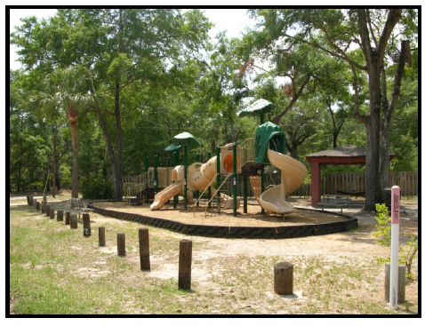
A.
Playground— Playgrounds are for active recreational use and provide sunny and shaded play equipment and play areas for children as well as open shelter with benches. Playgrounds may be part of other types of open space, such as parks, or may stand alone.
• Minimum Size: 10,000 square feet
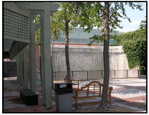
B.
Square— Squares are areas for passive recreational use. Squares shall be bounded by streets on a minimum of 50 percent of their perimeter. Squares are encouraged to be entirely bounded by streets and/or lanes. Squares shall be planted parallel to all streets and shall contain canopy trees along street frontages.
• Minimum size: 2,000 square feet
C.
Park— Parks may be designed for passive and/or active recreational use. Parks shall be bounded by streets on a minimum of 10 percent of their perimeter. Large parks should create a central open space which services an entire neighborhood or group of neighborhoods; or incorporates physical features which are an asset to the community (i.e. lake or river frontage, high ground, significant stands of trees). Undergrowth should be limited and landscaping shall be installed in a manner that promotes attractiveness and safety. Parks may be combined with greenways and greenbelts and may include golf courses and community gardens.
• Minimum size: 1 acre
D.
Green— The green is an open space which is more natural. Like the square, it is small and surrounded by buildings. Unlike the square, it is informally planted and may have irregular topography. Greens are usually landscaped with trees at the edges and open lawns at the center. Greens should contain no structures other than benches, pavilions, and memorials; paths are optional.
• Minimum size: 20,000 square feet

E.
Greenway— Greenways are large, irregular open spaces designed to incorporate natural settings such as creeks and significant stands of trees within and between neighborhoods. Greenways are typically more natural and may contain irregular topography. Greenways shall be used for certain active recreational uses including, at a minimum, trails for walking, jogging, and biking. Greenways shall connect points of interest in the community such as schools, parks, and other civic uses.
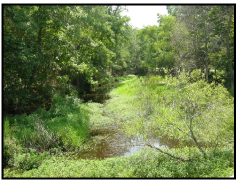
F.
Greenbelt— Greenbelts run along the perimeter of a neighborhood, and serve to buffer a neighborhood from surrounding non-compatible uses such as a highway corridor or industrial district, or a developed area from agricultural areas or adjacent cities. Greenbelts differ from the other types of open spaces in that they are left natural, and are not intended for recreational use.
G.
Agricultural Preserve— Open spaces designated as Agricultural Preserves shall be used for active farming in the form of crop cultivation, the keeping of livestock, or equestrian facilities. Agricultural Preserves are encouraged to protect areas of agricultural and rural heritage and promote compatible active agricultural operations.
• Minimum size: 5 acres
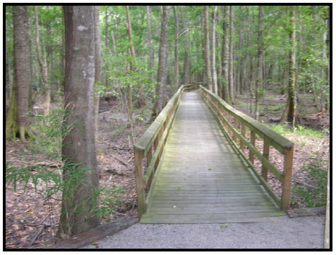
H.
Nature Preserve— Open spaces designated as Nature Preserves shall be left largely undisturbed except for the optional clearing of underbrush for the provision of a walking trail (mulch or other natural material only). Nature Preserve areas are encouraged to protect large stands of trees, wildlife, and natural water features. Nature Preserves are the preferred form of open space for steep slopes in excess of 25 percent grade.
• Minimum size: 3 acres
6.6.5 - Open Space Ownership & Maintenance
A.
Open space may be owned or administered by one or a combination of the following methods:
• Fee simple ownership by a unit of government or private non-profit land conservancy;
• Common ownership by Homeowners Association;
• Split deeded ownership by individual property owners within the subdivision;
• By individual private ownership such as a farmer, developer or other private entity that maintains the open space in accordance with the purposes of this Chapter. (i.e. farming, equestrian facility).
• Deed restricted open space easements on individual private properties.
B.
The City Council shall have the authority to accept or reject land dedications made as a requirement of this Section.
C.
The owner of dedicated open space shall be responsible for the continuing upkeep and proper maintenance of the same.
D.
In the case of common ownership by a Homeowners Association, the restrictive covenants shall provide that, in the event the Homeowners Association fails to maintain the open space according to the standards of this Ordinance, the City may, following reasonable notice, demand that deficiency of maintenance be corrected, or enter the open space to maintain it. The cost of such maintenance shall be charged to the Homeowners Association.
E.
The developer shall place in a conspicuous manner upon the Final Plat of the subdivision a notation concerning control of open space.
F.
The developer will provide proof of registration of the Sections of Incorporation with the appropriate state agency for the formation of the Homeowners Association to the Administrator.
G.
Homeowners' Associations or similar legal entities that are responsible for the maintenance and control of open space areas and common areas shall be established by the developer who shall record in the Register of Deeds a declaration of covenants and restrictions that will govern the association or similar legal entity. A copy of the recorded document shall be provided to the Administrator and such document shall include, but not be limited to, the following:
1.
Provision for the establishment of the association or similar entity is required before any lot in the development is sold or any building occupied and membership shall be mandatory for each homeowner and any successive buyer.
2.
The association or similar legal entity has clear legal authority to maintain and exercise control over such common open space areas.
3.
The association or similar legal entity has the power to compel contributions from residents of the development to cover their proportionate shares of the costs associated with the maintenance and upkeep of such common areas. Further, assessments levied can become a lien on the property if allowed in the master deed establishing the homeowners association or similar legal entity.
4.
The open space restrictions must be permanent, not just for a period of years.
5.
The association or similar legal entity must be responsible for liability insurance, applicable taxes and the maintenance of open space and other facilities under their control.
6.
The association or similar legal entity must be able to adjust the assessment to meet changing needs.
7.
The association shall be responsible for maintaining all public storm water drainage systems and easements within the subdivision not being maintained by the City, County, State or other approved entity.
8.
It shall be expressly stated within the restrictive covenants/homeowners association documents that it will be the responsibility of the developer or successors or assigns to enforce such covenants or restrictions until such time as control has been transferred to the Homeowners Association Board of Directors. It shall be the sole responsibility of the developer, successor or assigns to correct any deficiencies prior to transfer of control over to the Homeowners Association Board of Directors.
6.6.6 - Payment-in-Lieu of Dedication
A.
If open space within a development is physically impractical due to unusual conditions then the City may accept a fee paid in lieu of dedication.
B.
Fees collected in lieu of dedications and any proceeds from such transactions or sales shall be accounted for by the City, and the funds shall be used by the City for the purposes of acquiring and developing recreation, greenway and open space areas as shown on the land development plan or in the parks and recreation and greenway/bikeway master plans and for no other purposes. The depository for such funds may be the same as permitted other funds of the City, pending their expenditure in accordance with the terms of this code; such funds may be invested as other funds of the City. The City may, at its discretion, add additional monies to the fund for the purposes of purchasing open space and recreational land to be used for recreational purposes.
C.
Refunds shall not be granted to the developer should the project not be constructed after recording of Final Plat or if a reduction in density occurs.
D.
Such payment in lieu of dedication shall be the product of the current assessed market value of the land to be subdivided (as established in Subsection E below) multiplied by the number of acres to be dedicated.
E.
The current assessed market value of the gross land area of the development or subdivision at the time of submission of the required plan and/or plat shall be used to determine the land value. The current assessed market value shall be the appropriate value as determined by and maintained on file in the Colleton County Tax Office. The average value per gross acres shall be calculated from this total tax value and applied to the required recreational land area in order to determine the land value.
TOTAL MARKET VALUE OF UNDEVELOPED PROPERTY
X ACRES OF REQUIRED OPEN SPACE= PAYMENT
TOTAL ACRES OF UNDEVELOPED PROPERTY

