
Altamonte Springs City Zoning Code
DIVISION 25
MUD—MULTI-USE DEVELOPMENT
3.25.1 - Description of district.
The intent of the multi-use development future land use category is to provide a flexible low and medium intensity land use category for development and redevelopment of infill, vacant, and/or under utilized properties in the southwest quadrant of the city, where existing or future planned roadways make this area a southwestern gateway into the city from Orange County, the City of Maitland and Seminole County. The multi-use development future land use category is intended to promote a variety of individual uses as the focus of a development application while encouraging multiple uses within development projects through the availability of development incentives (higher intensity or density).
(Ord. No. 1304, § 2, 6-1-99; Ord. No. 1652-12, § 2, 12-4-12)
3.25.2 - Eligibility.
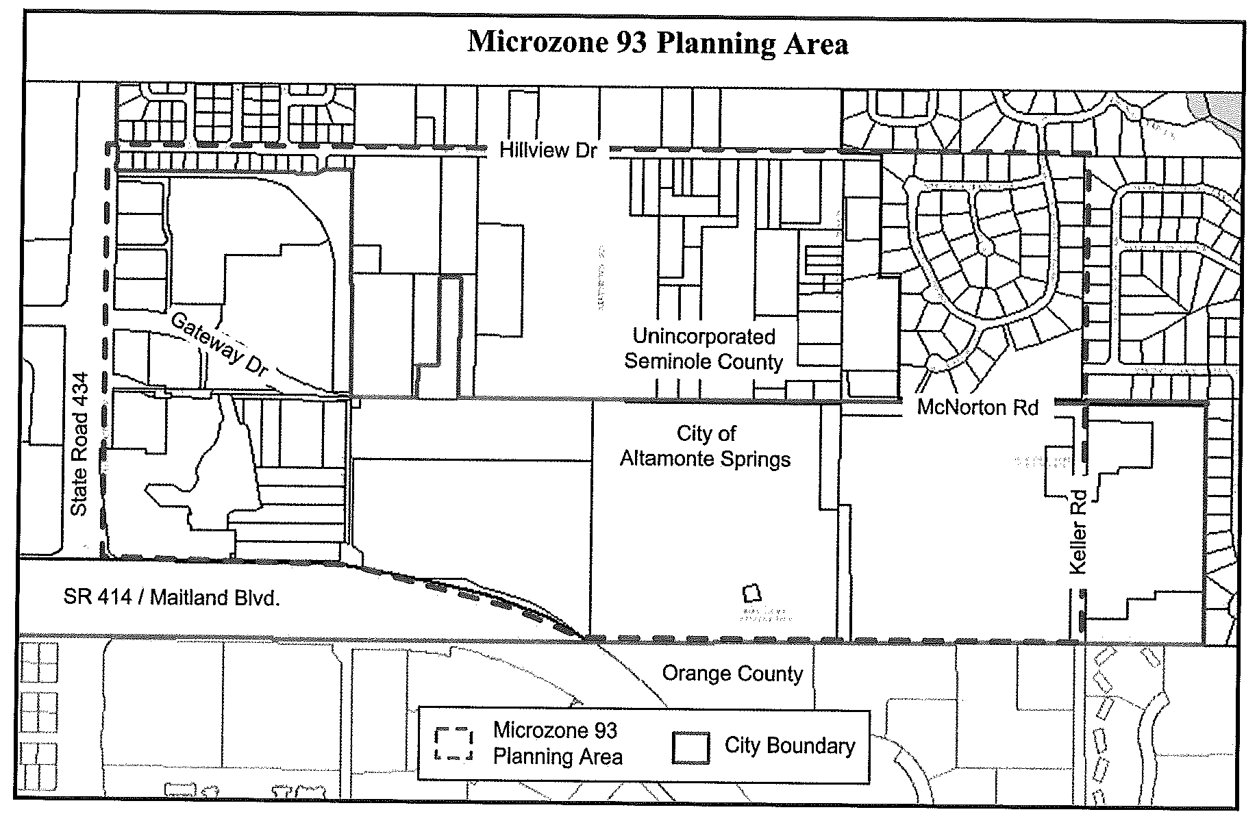
The multi-use development (MUD) future land use and zoning shall be permitted on parcels which are within the MicroZone 93 Planning Area, as illustrated on the map shown below. Only parcels which are within the MicroZone 93 Planning Area and which are contiguous to existing multi-use development districts will be eligible for this zoning district.
(Ord. No. 1304, § 2, 6-1-99; Ord. No. 1599-09, § 1, 3-3-09; Ord. No. 1617-09, § 3, 12-1-09; Ord. No. 1652-12, § 2, 12-4-12)
3.25.3 - Development use bank.
To ensure that multiple uses develop in multi-use development districts, no one use will be permitted to develop on more than 80 percent of the gross acreage of a multi-use development district, inclusive of floor area ratio (FAR). A multi-use development "district" is an area of land for which the multi-use development future land use category is approved. The city will evaluate compliance to this standard as follows:
(a)
Five days prior to submitting a preliminary plan, the developer shall submit a statement certifying that the property subject to development review is within the MicroZone 93 Planning Area. Such certification shall include:
(1)
Tax identification number for each parcel included on the site plan;
(2)
Total acres included on the site plan;
(3)
Total square feet and dwelling units shown on the site plan;
(4)
A listing of each "general use" shown on the site plan along with the total square feet or dwelling units which comprise that use. The "general uses" are shown in section 3.25.4, and are:
The growth management department will provide a form on which the certification is to be submitted. The form will be a required component of sufficiency reviews for MUD projects.
(b)
The city will evaluate the certification for capacity in the development use bank and issue an approval or denial based on such evaluation. The approval must be included in the sufficiency review for MUD projects.
(Ord. No. 1304, § 2, 6-1-99; Ord. No. 1599-09, § 1, 3-3-09; Ord. No. 1652-12, § 2, 12-4-12)
3.25.4 - Permitted uses and conditional uses.
(Ord. No. 1304-99, § 2, 6-1-99; Ord. No. 1491-03, § 1, 3-2-04; Ord. No. 1652-12, § 2, 12-4-12; Ord. No. 1720-17, § 3, 12-5-17)
3.25.5 - Intensity and density regulations.
Refer to division 30, development intensity standards, for density and intensity requirements.
(Ord. No. 1304, § 2, 6-1-99; Ord. No. 1588-08, § 2, 5-20-08; Ord. No. 1652-12, § 2, 12-4-12)
3.25.6 - Sector plans and DRI requirements.
(a)
Should an individual project exceed the criteria set forth in subsections (1) or (2) below, a special planning study on the proposed site and on the area surrounding the proposed development site must be completed prior to the city issuing a final development order. The criteria are:
(1)
If the size and magnitude of the project(s) would require an area-wide development of regional impact application, pursuant to the criteria contained in F.S. ch. 380.06, either government-sponsored or private-development sponsored; or
(2)
The total development exceeds 100,000 square feet.
The special planning study will include a full analysis of the following:
a.
Review of existing conditions;
b.
Development and land use patterns;
c.
Proposed land use concepts;
d.
Development constraints and opportunities, including redevelopment and mixed-uses;
e.
Major planning considerations;
f.
Site development concept;
g.
Factors affecting development;
h.
Services and facility needs;
i.
Implementation and phasing;
j.
Land use performance standards, including special features and amenities that might warrant incentives;
k.
Recommendations for capital improvements for transportation, infrastructure, park facilities and recreation opportunities, conservation, stormwater management, etc.;
l.
Other issues as defined by the growth management director.
(b)
Criteria and methodology shall be set by the growth management director.
(Ord. No. 1304, § 2, 6-1-99)
3.25.7 - Building height requirements.
(a)
The permitted height for any building or structure is six stories and may be up to 12 stories through development bonuses. Up to three levels of parking will not be counted toward the maximum story requirements if located under the building. A shading study may be required to determine any effects of shadows cast on neighboring lands or structures. Results of the shading study will be reviewed by the growth management director. (See division 46 for development bonus information.)
(b)
A building or structure height over six stories and up to a maximum height of 12 stories will be permitted if the following standards are met:
(1)
The proposed building height is included on all site plans (conceptual plans) submitted to the city.
(2)
A development incentive is awarded for unique architectural features and design. (See division 46 for development bonus information.)
(3)
A development incentive is awarded for the additional height. (See division 46 for development bonus information.)
(4)
Detailed architectural drawings with elevations, materials and colored renderings are submitted for review to the development review committee prior to any approval. Also required is a sample of all textures and materials and may include a scaled model.
(5)
A shading study is submitted for review.
(6)
Any change (substantial or nonsubstantial) to the building height and/or materials, or to a previously approved plan, must be submitted to the growth management department for review. The growth management director shall have the discretion to require such changes to be returned to the planning board for review and approval. Any major or substantial change to the building height and/or materials, or to a previously approved plan, which affects the intent and character of the development, approved land use plan, final development order and developers agreement, shall be reviewed and approved by the city commission upon receipt of the recommendation of the planning board. If the requested changes are deemed to have a substantial effect on adjacent property owners, residents of the area under an approved MUD plan or the general public, involves an increase in density or a change in the phasing, the city commission shall cause a public hearing to be held prior to official action on said requested change. A request for a revision of the land use map or development order shall be supported by a written statement demonstrating the reasons the revisions are necessary or desirable. Such changes as determined by the growth management director to be nonsubstantial may be resubmitted to the development review committee for review and approval.
(Ord. No. 1304, § 2, 6-1-99; Ord. No. 1617-09, § 3, 12-1-09 Ord. No. 1652-12, § 2, 12-4-12)
3.25.8 - Lot requirements.
(a)
Minimum lot area. None except to meet other requirements set forth herein and all other applicable city regulations.
(b)
Minimum lot width. 100 feet at front lot line or building line.
(Ord. No. 1304, § 2, 6-1-99)
3.25.9 - Building setback requirements.
(a)
Front yard. A minimum distance of 25 feet shall be provided from the closer of the front lot line or the existing or planned rights-of-way to the building site. If a development bonus is granted for transit improvements adjacent to the front yard, the front yard building setback may be reduced to 15 feet.
(b)
Side yard. A minimum distance of ten feet shall be provided, unless specifically approved as part of the site plan process. If a side yard abuts a right-of-way, the setbacks shall be computed as front yards.
(c)
Rear yard. A minimum distance of 25 feet shall be provided from the property line to building site. If a development bonus is granted for transit improvements adjacent to the rear yard, the rear yard building setback may be reduced to 15 feet.
(d)
Abutting residential.
(1)
When a nonresidential use abuts a residential use, a minimum distance of 30 feet shall be provided from the property line to building site. Where the building is between 30 feet and 75 feet in height, the setback shall be 50 feet.
(2)
When a building or structure located within a project is adjacent to existing single-family or multifamily structures and is proposing buildings or structures above 75 feet in height, five feet of additional building setback for each additional story above 75 feet shall be required.
(3)
Low intensity lighting for parking lots may be required on a case-by-case basis. These requirements shall be in effect when abutting one- or two-family dwellings.
(e)
Additional setback requirements. Greater setbacks may be required on certain properties in order to accommodate cross-access easements and other rights-of-way as may be required under article XI, Access Control, division 7, Joint-Use Driveways, Cross Access Connections, and Service Road Provisions, of this Code. Also: See table in article XI for setbacks on specific major roadways.
(Ord. No. 1304, § 2, 6-1-99; Ord. No. 1652-12, § 2, 12-4-12)
3.25.10 - Landscape and buffer regulations.
Landscaping and buffer requirements shall comply with the minimum standards established in article VIII, Landscaping and Tree Protection, of the Land Development Code, and with the standards established in the Gateway Center Design Guidelines and Standards.
(Ord. No. 1304, § 2, 6-1-99; Ord. No. 1652-12, § 2, 12-4-12)
3.25.11 - Parking regulations.
(a)
Parking may be allowed in any required yard, but shall not encroach into any required landscape area, or where otherwise prohibited. For complete design standards see division 41 of article III of this Code.
(b)
Parking reductions. In order to reduce overall parking needs, the parking space requirements and the size of parking stalls may be reduced for any site where the owner-developer provides to the city a parking management plan. This plan must demonstrate effective measures to reduce the need for parking on-site. Such measures are not limited to the following:
(1)
Cross-access for vehicles;
(2)
Integration of pedestrian ways and bicycle facilities into parking area;
(3)
Circulation design to integrate adjoining uses;
(4)
Encourage transit ridership or provide transit facilities or connections on-site;
(5)
Use of car pooling, van pools, or any other system which reduces the number of normally required parking spaces;
(6)
Payments in lieu of parking to a trust fund for structured parking garages;
(7)
Staggered work hours;
(8)
Shared parking agreements.
(Ord. No. 1304, § 2, 6-1-99)
3.25.12 - Sign regulations.
(a)
Consistent with article III, division 42 of the Land Development Code, the sign regulations for this district shall be the same as for the use most similar to the one in question. The determination of which regulations will apply shall be made by the growth management director. All signs must conform to the Gateway Center Design Guidelines and Standards. In this regard, when the Land Development Code and the Gateway Center Design Guidelines and Standards are in conflict, the more restrictive shall apply.
(b)
When a mixture of uses exists within a development, different regulations may be applied without regard to phases or see division 42 of article III of this Code.
(Ord. No. 1304, § 2, 6-1-99; Ord. No. 1652-12, § 2, 12-4-12)
3.25.13 - Open space and recreation area requirements.
See article III, division 44.
(Ord. No. 1304, § 2, 6-1-99)
3.25.14 - Dwelling size requirement.
Excluding hotel and motel rooms, the minimum dwelling size for a residential unit shall be 500 square feet.
(Ord. No. 1304, § 2, 6-1-99)
3.25.15 - Animal regulation.
For animal regulation, see article III, division 44.
(Ord. No. 1304, § 2, 6-1-99)
3.25.16 - Reserved.
Editor's note— Ord. No. 1588-08, § 1, adopted May 20, 2008, repealed the former § 3.25.16, which pertained to development bonuses and derived from Ord. No. 1304, § 2, adopted June 1, 1999. Ord. No 1588-08, enacted a new art. III, div. 46, which set out similar provisions.
3.25.17 - Enclosed buildings.
All uses and storage shall be maintained within an enclosed permanent building.
(Ord. No. 1652-12, § 2, 12-4-12)