
Altamonte Springs City Zoning Code
DIVISION 30
DEVELOPMENT INTENSITY STANDARDS
3.30.1 - Intensity matrix.
Development of property shall comply with the minimum and maximum densities and intensities contained in Table 30.1, Intensity Matrix. Development bonuses must be earned pursuant to article III, division 46, of this Code. Density/intensity will be set during the site plan review process based on infrastructure capacity and any bonuses received. No project shall be approved at any density which exceeds the capacity of water, sewer, or traffic circulation systems serving the site, taking into account other existing and approved project demands.
TABLE 30.1 INTENSITY MATRIX
| Future Land Use Categories | Consistent Zoning Districts | FAR or DU/Ac | Minimum | Maximum | Maximum with Development Bonuses |
|---|---|---|---|---|---|
| Non-Activity Center Future Land Use Designations | |||||
| Low Density Residential | R-1A, R-1AA, R-1AAA | DU/Ac | None | 5 | — |
| R-1 | DU/Ac | None | 5 | — | |
| PUD-RES | DU/Ac | None | 5 | — | |
| CD | FAR | None | 0.10 | — | |
|
Medium Density
Residential | R-2 | DU/Ac | >5 | 10 | — |
| R-3 | DU/Ac | >5 | 10 | — | |
| R-M | DU/Ac | >5 | 10 | — | |
| PUD-RES | DU/Ac | >5 | 10 | — | |
| PUD-MO | DU/Ac | >5 | 10 | — | |
| CD | FAR | None | 0.10 | — | |
| Office/Residential | PUD-RES | DU/Ac | >5 | 18 | — |
| PUD-COM | FAR | None | 0.30 | — | |
| PUD-MO | FAR | None | 0.30 | — | |
| DU/Ac | >5 | 18 | — | ||
| MOR-1 | FAR | None | 0.25 | — | |
| DU/Ac | >5 | 10 | — | ||
| MOR-2 | FAR | None | 0.30 | — | |
| DU/Ac | 10 | 18 | — | ||
| IN | FAR | None | 0.30 | — | |
| CD | FAR | None | 0.10 | — | |
| Commercial/Office | PUD-COM | FAR | None | 0.35 | — |
| PUD-MO | FAR | None | 0.35 | — | |
| G-O | FAR | None | 0.35 | — | |
| C-L | FAR | None | 0.25 | — | |
| C-G | FAR | None | 0.35 | — | |
| MOC-1 | FAR | None | 0.35 | — | |
| DU/Ac | 10 | 18 | — | ||
| IN | FAR | None | 0.35 | — | |
| CD | FAR | None | 0.10 | — | |
| Industrial | PUD-COM | FAR | None | 0.30 | — |
| PUD-MO | FAR | None | 0.30 | — | |
| I-L | FAR | None | 0.30 | — | |
| MOI-1 | FAR | None | 0.30 | — | |
| IN | FAR | None | 0.30 | — | |
| Institutional | PUD-COM | FAR | None | 0.35 | — |
| PUD-MO | FAR | None | 0.35 | — | |
| IN | FAR | None | 0.35 | — | |
| Conservation | CD | FAR | None | 0.10 | — |
| Activity Center Future Land Use Designations | |||||
| Regional Business Center | R-4 | DU/Ac | 10 | 25 | 35 |
| PUD-MO | FAR | 0.25 | 0.50 | 1.00 | |
| DU/Ac | 10 | 25 | 35 | ||
| G-O | FAR | 0.25 | 0.35 | 0.50 | |
| C-L | FAR | 0.25 | 0.35 | — | |
| C-G | FAR | 0.25 | 0.35 | 0.50 | |
| MOR-1 | FAR | 0.25 | 0.35 | — | |
| DU/Ac | 10 | 18 | — | ||
| MOR-2 | FAR | 0.25 | 0.50 | 0.75 | |
| DU/Ac | 10 | 25 | 35 | ||
| MOC-2 | FAR | 0.25 | 0.50 | 1.00 | |
| DU/Ac | 10 | 25 | 35 | ||
| IN | FAR | 0.25 | 0.50 | 1.00 | |
| CD | FAR | None | 0.10 | — | |
| Regional Business Center - Core East | R-4 | DU/Ac | 25 | 35 | 80 |
| MOR-3 | FAR | 0.40 | 1.00 | 3.50 | |
| DU/Ac | 25 | 35 | 80 | ||
| MOC-3 | FAR | 0.40 | 1.00 | 3.50 | |
| DU/Ac | 25 | 35 | 80 | ||
| CD | FAR | None | 0.10 | — | |
| Regional Business Center - Core West | R-4 | DU/Ac | 10 | 25 | 35 |
| PUD-MO | FAR | 0.40 | 0.80 | 2.00 | |
| DU/Ac | 10 | 25 | 35 | ||
| G-O | FAR | 0.40 | 0.75 | 1.00 | |
| MOR-3 | FAR | 0.40 | 1.00 | 3.50 | |
| DU/Ac | 10 | 25 | 35 | ||
| MOC-2 | FAR | 0.40 | 0.80 | 2.00 | |
| DU/Ac | 10 | 25 | 35 | ||
| MOC-3 | FAR | 0.40 | 1.00 | 3.50 | |
| DU/Ac | 10 | 25 | 35 | ||
| MOI-2 | FAR | 0.40 | 0.50 | 1.00 | |
| IN | FAR | 0.40 | 1.00 | 3.50 | |
| CD | FAR | None | 0.10 | — | |
| East Town Center | C-L | FAR | 0.15 | 0.25 | — |
| C-G | FAR | 0.15 | 0.35 | 0.50 | |
| MOR-2 | FAR | 0.15 | 0.35 | 0.50 | |
| DU/Ac | 10 | 18 | 25 | ||
| MOC-2 | FAR | 0.15 | 0.35 | 0.50 | |
| DU/Ac | 10 | 18 | 25 | ||
| MOI-2 | FAR | 0.15 | 0.35 | 0.50 | |
| IN | FAR | 0.15 | 0.35 | 0.50 | |
| CD | FAR | None | 0.10 | — | |
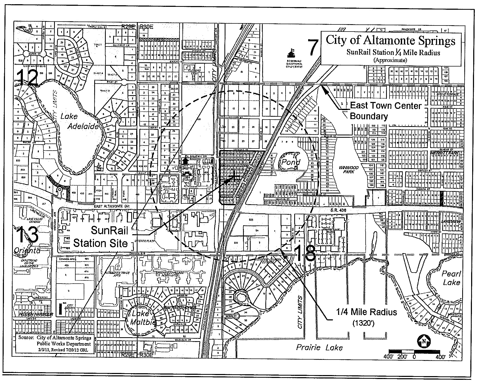
| East Town Center, generally within ¼-mile of the SunRail Station site (refer to map in Exhibit 30-1) | FAR | 0.25 | Same as the zoning maximums | 1.00* | |
| DU/Ac | 15 | 50* | |||
| * Additional potential bonus beyond that allowed by the zoning district for site designs which significantly contribute to the area's transit-oriented development pattern. | |||||
| Comprehensive plan policy 1-1.2.15 states that, generally within a ¼-mile of the proposed commuter rail station, a minimum of 15 dwelling units per acre and an FAR of 0.25 is required with the potential increase in the development bonus up to a maximum 50 dwelling units per acre or a maximum of 1.0 FAR for site designs which significantly contribute to the area's transit-oriented development pattern. | |||||
| Gateway Center | PUD-MO | FAR | 0.25 | 0.50 | 0.75 |
| DU/Ac | 10 | 18 | 25 | ||
| MOR-2 | FAR | 0.25 | 0.50 | 0.75 | |
| DU/Ac | 10 | 18 | 25 | ||
| MOC-2 | FAR | 0.25 | 0.50 | 0.75 | |
| DU/Ac | 10 | 18 | 25 | ||
| MUD | FAR | 0.25 | 0.50 | 0.75 | |
| DU/Ac | 10 | 18 | 25 | ||
| IN | FAR | 0.25 | 0.50 | 0.75 | |
| CD | FAR | None | 0.10 | — | |
| West Town Center | PUD-MO | FAR | 0.15 | 0.35 | 0.50 |
| DU/Ac | 10 | 18 | 25 | ||
| C-G | FAR | 0.15 | 0.35 | 0.50 | |
| MOR-2 | FAR | 0.15 | 0.35 | 0.50 | |
| DU/Ac | 10 | 18 | 25 | ||
| MOC-1 | FAR | 0.15 | 0.35 | 0.50 | |
| DU/Ac | 10 | 18 | 25 | ||
| MOC-2 | FAR | 0.15 | 0.35 | 0.50 | |
| DU/Ac | 10 | 18 | 25 | ||
| IN | FAR | 0.15 | 0.35 | 0.50 | |
| CD | FAR | None | 0.10 | — | |
Matrix acronyms:
DU/Ac - dwelling units per acre
FAR - floor-area ratio
FLU - future land use
Intensity matrix notes:
1)
Refer to the zoning district list of uses for information concerning use requirements, such as whether a residential or commercial use is allowed only as a support use, mixed use project requirements, maximum project size limits, or other parameters.
2)
Calculation methodologies are contained in Land Development Code section 1.2.1 under the definitions of "density, residential," "floor area," and "floor area ratio."
EXHIBIT 30.1
SUNRAIL STATION ¼-MILE RADIUS
(Ord. No. 1652-12, § 3, 12-4-12)
3.30.2 - Relationship to the comprehensive plan.
The future land use element of the comprehensive plan establishes a range of residential densities and nonresidential intensities for each of the city's future land use categories. Allowable density and intensity shall be regulated by the specific zoning district classification within the ranges of the respective underlying future land use categories. This division of the zoning regulations establishes the specific densities and intensities for each of the zoning district classifications, arranged by future land use category.
(Ord. No. 1652-12, § 3, 12-4-12)