
Altamonte Springs City Zoning Code
DIVISION 26
EAST TOWN SPECIAL PLAN
3.26.1 - Description of the East Town Special Plan Zoning Overlay District.
The East Town Special Plan is a zoning overlay district, denoted by an "(SP)" after the base zoning district on the zoning map, that uses a transition-based planning approach for those properties located within the special plan (SP) boundaries to promote and implement a mixed-use district that focuses on multi-modalism, walkable streets and access to transit shown through mobility improvements.
(Ord. No. 1827-24, § 2, 10-15-24)
3.26.2 - Implementation of the East Town Vision Plan.
The overall purpose of the East Town Special Plan zoning overlay is to implement the East Town Vision Plan. The original vision plan supports the sunrail commuter rail service by guiding the city to implement several concepts, including managing the development character of this area of the city as an urban environment, positioning transit-oriented development surrounding the commuter rail station, connecting development within the area as part of a larger whole, and implementing a neighborhood protection buffer to surrounding residential development within the East Altamonte community. The specific objectives of this vision plan are to implement the following:
(1)
Design standards supporting multi-modal transportation and transit-oriented development;
(2)
Appropriate zoning categories and development densities/intensities;
(3)
Pedestrian and bicycle access and circulation network;
(4)
Set the table for economic development to occur in support of the SunRail Station, and support other mobility improvements in the area.
(Ord. No. 1827-24, § 2, 10-15-24)
3.26.3 - Relationship to comprehensive plan.
The comprehensive plan policies 1-1.2.13 through 1-1.2.16 call for changes to various development standards and new design standards to implement the East Town Vision Plan. The East Town Vision Plan, as adopted on March 18, 2014, by Ordinance No. 1674-14, identifies the development character of this area of the city, envisioning a unique, quality community achieved through diverse land uses with modern amenities (parks, lakes, urban plazas, walkways and landscaping), and multimodal transportation alternatives that meet the needs of residents and businesses. The vision plan also included a neighborhood protection buffer concept to protect the surrounding neighborhoods from pervasive gentrification, per comprehensive plan policy 1-1.2.16.1.
(Ord. No. 1827-24, § 2, 10-15-24)
3.26.4 - Support documents.
The standards of this East Town Special Plan zoning overlay are intended to implement the recommendations provided in the East Town Redevelopment Strategy and Action Plan Support Document, and the East Town Vision Plan Executive Summary (both adopted March 18, 2014). These support documents provide the basis for clarifying the intent of the regulations contained in this division and serve as a guideline for the review of discretionary land use permits by the development review committee (DRC). These support documents may be amended from time to time by the planning board.
(Ord. No. 1827-24, § 2, 10-15-24)
3.26.5 - Application.
The standards of the East Town Special Plan zoning overlay apply to those properties located within the City of Altamonte Springs depicted in Figure 1. Properties shown in Figure 1 that are in the county will be subject to the East Town Special Plan zoning overlay if they are annexed into the city and assigned a zoning district with the appropriate zoning overlay "(SP)". This is a transition-based special plan zoning overlay, and standards vary by each transition area. Each transition is described in detail in the sections below and is designated as shown in Figure 1.
(Ord. No. 1827-24, § 2, 10-15-24)
3.26.6 - Review process.
All properties located in the East Town Special Plan zoning overlay undergoing site and external building improvements, substantial improvement, substantial enlargement, or redevelopment are subject to this special plan zoning overlay. Existing legally non-conforming uses, buildings or sites are not required to meet the special plan zoning overlay until the property undergoes redevelopment, subject to the relevant review process. Review for compliance with the zoning overlay must be accomplished through DRC review.
(Ord. No. 1827-24, § 2, 10-15-24)
3.26.7 - Transition area assignment.
The transitions described below are intended to supplement the Land Development Code, in order to transition between the surrounding area and the properties encompassing the special plan zoning overlay, to relate each development to the overall development of the activity center, and to provide additional flexibility and development rights that support the East Town Vision Plan.
The following areas ("transitions areas"), as depicted in Figure 1, are described as follows:
(1)
T3.5: Neighborhood Transition. This area represents a transition between the existing low-density residential neighborhoods surrounding the special plan zoning overlay at the edge of the activity center. The surroundings contain predominately single-family dwelling units, as well as this neighborhood transition area. Interspersed in this neighborhood transition are low density offices, live/work-type uses and a variety of small scale residential units. Requests for re-zonings to allow additional intensity or to change the residential and office character of these areas are generally discouraged. Development in the neighborhood transition often shifts the mass, scale and character of the area towards a mix of residential dwelling types (single-family, accessory units, duplexes, townhomes, small apartments) and some compatible non-residential uses, such as offices. Buildings are typically one—2.5 stories.
(2)
T4: General Urban. This transition area is characterized by increased urban development over the neighborhood transition area and is intended to promote a mix of commercial, office, residential, and mixed-use buildings that are appropriately scaled as being peripheral to a typical "Main Street" area. Buildings are typically two—four stories (a minimum of two-story heights is preferred). Horizontal mixed-uses (side-by-side in one or more buildings) may be allowed, but vertical mixed-uses (upper floors have a different use than the ground floor) are preferred. Development in this transition area, and more intense areas, supports transit by orienting itself to the street, providing connectivity for walking, and incorporating mobility connections to the nearby SunRail Station.
(3)
T5: Urban Center. The primary intent of this transition area is to create a vibrant mixed-use place for residents and visitors alike that is walkable and provides opportunities for a mixture of compatible land uses such as residential, commercial, retail, office, and potential entertainment uses. The design of sites in the urban center area should allow residents and visitors to easily walk between buildings and active ground floor uses by creating a walkable street network and other internal connections; off-street parking must be located behind the buildings and supplemented with on-street parking. While vertical mixed-uses are preferred, horizontal mixed-uses and single-use commercial, office or residential buildings will be allowed if they are designed to conform to the urban form designated for this area. Buildings are typically two—five stories (requiring a minimum of two-story heights) with a potential for more intense development using development bonuses. Open space within this transition area must be provided in the form of amenity areas, streetscapes and public plazas that are more urban in character.
(4)
T6: Urban Core. The primary intent of this transition area is to allow intense, urban redevelopment to create a vibrant, transit-oriented neighborhood with a mix of residential, retail and office uses. This area will focus on allowing high intensity development that supports public transit users as well as bicycling and walkable streets. Buildings are typically two—seven stories with the potential for more intense development with density bonuses.
Figure 1 East Town Special Plan Zoning Overlay
(Ord. No. 1827-24, § 2, 10-15-24)
3.26.8 - Use standards.
(a)
Permitted uses. The permitted and conditional uses within the East Town Special Plan zoning overlay boundaries shall be as specified for the underlying zoning district set forth in the Land Development Code, article III Zoning Regulations, with the following modifications:
(1)
Hotels and their accessory uses are permitted by right within the T4, T5 and T6 transition areas.
(2)
Live/work flex space uses shall be allowed throughout all of the transition areas.
(b)
Specific use standards. For those specific uses detailed below, the following standards are provided to accommodate these automobile intensive uses while working to preserve and enhance the walkability focus of the East Town Special Plan area:
(1)
Auto repair, carwash: If allowed in the underlying zoning district, all principal and accessory structures used for automobile service shall be located and constructed in accordance with the following requirements:
a.
Bay openings must be located to the side or rear of the buildings, and must be screened from view from any street by a building or other method acceptable to the growth management director.
b.
Bay openings must be architecturally integrated into the building design.
c.
All bay openings must be oriented away from adjacent single family residential districts and any other existing residential uses. Accessory car wash structures shall not exceed 20 feet in height.
(2)
Automotive services: Automotive services are auto-oriented uses regulated by the underlying zoning district. However, all automotive services must meet the standards of this section and the following additional provisions:
a.
Service station pumps must be located to the side or rear of the main building, and are not allowed in front of the building.
b.
A streetwall, with landscaping in front, must be provided to screen vehicular use areas if visible from any street, as required by the streetwall requirements below.
c.
Auto repair bay and car wash openings, service and storage areas, and refuse enclosures must be oriented away from public view.
d.
Gas station canopy clearance may not exceed 18 feet.
e.
Gas stations and canopy roofs must not be flat and must incorporate architectural features of the primary building, such as decorative columns, roofing forms and durable materials (tile, stone, and other durable, non-stucco materials for at least the first three-foot of the elevation of the canopy and principal building).
(3)
Drive-through facilities: Drive-through facilities are auto-oriented and therefore discouraged from locating within the East Town Special Plan zoning overlay. Drive-through facilities integrated into structured parking may be approved with a conditional use, provided all of the following additional standards for drive-through facilities are met. If an applicant does not integrate the drive-through facilities in a building or structured parking garage, only one drive-through lane may be reviewed during the conditional use process and will also be subject to the following additional standards:
a.
Drive-through facilities may not be directly accessible along any streets within the East Town Special Plan and not be visible or accessed along SR 436 and Ronald Reagan Boulevard. The access management for such facilities will be reviewed to minimize the number of vehicular access points.
b.
Access points to public streets shall be provided through the overall access to the site and may not provide singular access to a drive-through for entry or exiting (i.e., additional vehicular access points are prohibited when planning a drive-through).
c.
Drive-through lanes and windows must be located along the side or rear of buildings, away from street frontages.
d.
Adequate queuing space must be provided for drive-through windows and order stations in compliance with the city Code and any professional standards and reports for anticipated queue lengths.
e.
A streetwall, minimum three-feet in height, with landscaping shall be provided to screen all vehicular use areas.
Drive-throughs will not have reduced mobility fees within the East Town Special Plan zoning overlay, and shall be charged the maximum rate provided within the city.
(Ord. No. 1827-24, § 2, 10-15-24)
3.26.9 - Development standards.
Table 1. Alternative development standards for all transition areas within the East Town Special Plan zoning overlay
(1)
See division 45, article III for development bonus information.
(2)
In the case where the required building frontage cannot be met due to the need to provide vehicular access from the street, a gateway, arch, streetwall or similar feature shall be provided to preserve the block continuity and may be counted toward meeting the building frontage requirement.
(3)
Single-family, duplex, and public assembly uses are not subject to the minimum frontage requirements.
(4)
Maximum setbacks will be measured from the edge zone to the primary building. The minimum standards for the streetscape area must be met, by transition area, to create a consistent streetscape as provided in the below streetscape standards.
(5)
If a side yard abuts a right-of-way, the setbacks will be computed as front yards.
(6)
Unless waived by the growth management director, a minimum distance of 30-foot rear setback shall be provided from the rear property line to building for the interior of a block in the T4, T5 and T6 transition areas. Where a building exceeds 30 feet in height abutting residential, the setback shall be equal to the height of such structure and parking will not be permitted in the 30-foot setback. Low intensity lighting for parking lots may be required on a case-by-case basis; these requirements shall be in effect when abutting one- and two-family dwellings. When a building or structure adjacent to existing single-family or multifamily uses is greater than 75 feet in height, five feet of additional building mass setback must be provided for each additional story above 75 feet.
(7)
Modification to a lesser standard may be available when an alternative open space plan conforms to alternative requirements meeting the intent of the zoning overlay district and the East Town Vision Plan and is approved by the planning board. Such alternative(s) that may be considered include:
a.
Urban open space by providing plazas, greens and/or squares that have seating, art, shade, or any amenities that are designed to create an active urban space.
b.
The use of low impact design such as bioswales, raingardens, or other innovative stormwater drainage techniques.
(Ord. No. 1827-24, § 2, 10-15-24)
3.26.10 - Street designation and design.
(a)
Street standards. The East Town Vision Plan developed an overall street network and will be used to evaluate new streets, designations, and overall connectivity for any new development within the East Town Special Plan zoning overlay boundaries.
(b)
All street frontages must adhere to the East Town Vision Plan and streetscape standards below, including dedicated space for people walking, bicyclists, and motor vehicles. On-street parking and appropriate landscaping must also be included. The specific configuration of the street frontage and street(s) within the available right-of-way will be determined after the growth management director's review during the relevant process as part of the engineering and design for the required street improvements.
(Ord. No. 1827-24, § 2, 10-15-24)
3.26.11 - Street classifications.
Streets within the East Town Special Plan zoning overlay shall be classified as arterial (Ronald Reagan and East SR 436), core, urban, and neighborhood transition as determined by the growth management director when considering the adjacent transition area designated in Figure 1, East Town Special Plan zoning overlay.
(1)
Streets in the East Town Special Plan zoning overlay must be designed with the primary goals of assuring comfort for people walking, promoting safety and increasing mobility options. All streets must be public.
(2)
Private rights-of-way, gated communities, dead-end streets and cul-de-sacs are prohibited.
(3)
Access drives within developments designed to function as streets do not have to be dedicated as public streets.
(4)
The design of each street must adhere to the specifications and cross-section illustrations for each street type provided in the East Town Vision Plan and associated documents.
(Ord. No. 1827-24, § 2, 10-15-24)
3.26.12 - Block length.
The maximum block length permitted is 400 feet.
(Ord. No. 1827-24, § 2, 10-15-24)
3.26.13 - Streetscape standards (roadside standards).
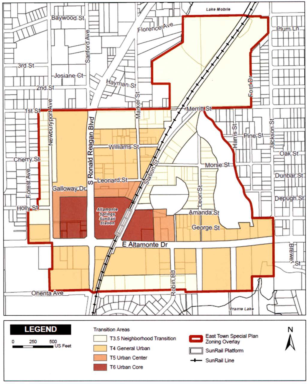
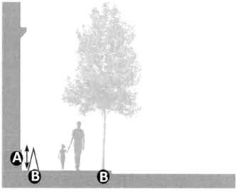
The public right-of-way typically includes a planting area and sidewalk, from the back of the curb to the front property line of adjacent parcels (enhanced with any necessary easements). The roadside is further divided into a series of zones, as illustrated in Figure 2 and Table 2, Streetscape Standards, that emphasize different functions including frontage, walkway, furnishing and edge zones. The function of roadside zones and the walkability level of the roadside are directly related to the activities generated by the adjacent context. These recommended standards promote a cohesive and multi-modal design of the transportation network in order to activate the public realm, create a walkable environment, and expand opportunities for active transportation throughout the city. All private and public streets shall meet the requirements of this section.
(1)
"Frontage zone" is the transition area between the travel way for walking and a building and/or outdoor seating areas. This zone may include small landscape area(s) such as potted plants, seating area(s) and any railings, tables that are installed for outdoor seating and/or other plazas and spaces for walking and patrons of the adjacent building to use.
(2)
"Walkway zone" is the area in which people may travel by foot continuously without obstruction. This zone must provide a minimum horizontal and vertical clear area to allow for comfortable walking.
(3)
"Furnishing zone" is a multi-purpose area that serves as a buffer between the travel way for walking and the vehicular area of the thoroughfare within the curbs, and it provides space for street trees, planting strips, street furniture, utility poles, A-frame signs, signals, electrical cabinets, fire hydrants, bicycle racks/storage, and transit shelters.
(4)
"Edge zone" is the transition area between the furnishing zone and provides space for the door swing from vehicles in the parking lane, for parking meters, and for the overhang of diagonally parked vehicles. The edge zone is wider along state roads to meet FDOT standards and may include additional walkways and landscape that are permitted, per FDOT design manual(s), yet shall match the appropriate state context classification generally based on the assigned transition area.
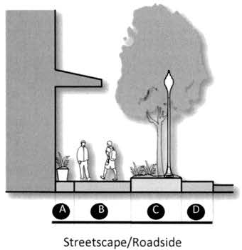
Figure 2. Streetscape Standards - Section
Table 2. Streetscape Standards
(1) Outdoor seating requires a minimum width of 4 feet. Outdoor seating with alcohol sales shall have a barrier treatment around the seating area approved by the Growth Management Director.
(2) Tree species shall be reviewed by the Development Review Committee and final determination will be reviewed against the overall block and adjacent landscape of the surrounding area(s) unless the existing landscape palette is not consistent with the future design of the East Town Special Plan.
(3) Within the limits of clear sight triangles, the tree canopy must be at least 9 feet above the ground level and the top of the ground cover and shrubs must be maintained at least 1.5 feet above ground level.
(Ord. No. 1827-24, § 2, 10-15-24)
3.26.14 - Walking network standards.
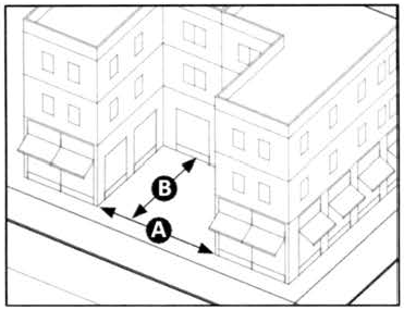
The walking network must provide direct walkways from building entries to the street, to surrounding buildings, and adjacent parcels within the East Town Special Plan. The typical pathways must be provided:
(1)
Along roadways, alleys, parking lots that will assist in walkability access to adjacent parcels, parking areas and pathways to transit; or
(2)
Pass-throughs located at mid-block locations or other "dead ends" on development sites.
Additional walkways may be required to ensure an overall walking network within the East Town Special Plan as reviewed by the development review committee.
(Ord. No. 1827-24, § 2, 10-15-24)
3.26.15 - Walkway design.
(a)
Internal walkways (minimum of six feet in width) shall be well lit and physically separated from driveways and parking spaces by landscaping, hardscape, grade separations, or other means to protect walkers from vehicular traffic.
(b)
A crosswalk with additional design treatment (colored concrete, speed table intersections, raised crosswalks) shall be required when a sidewalk crosses a driveway or a paved area accessible to vehicles. The treatment shall be selected in coordination with the city transportation engineer, based on the context.
(c)
Raised crosswalks or other traffic-calming measures shall be used to slow traffic whenever possible on public rights-of-way.
(d)
The walking network shall be in a connected block pattern throughout the developed area. Walkway connections to other facilities should occur every 200 feet at a minimum.
(Ord. No. 1827-24, § 2, 10-15-24)
3.26.17 - Parking lot design.
Parking lots must be designed to allow people to safely move from their vehicles to the building. On small lots (30 spaces or less), this may be achieved by providing a sidewalk at the perimeter of the lot. On larger lots, corridors within the parking area should channel walking from the car to the perimeter of the lot or to the building. These corridors are delineated by a paving material that differs from that of vehicular use areas and shade providing landscaping.
(1)
Parking Lots containing more than 30 stalls must have clearly defined walkway connections provided between:
a.
A public right-of-way and building entrances.
b.
Parking lots and building entrances.
(2)
Walkways shall be landscaped with additional shade or ornamental trees equal to an average of one shade tree per 50 linear feet of walkway unless the walkway is adjacent or included within an existing compliant buffer or frontage planting. The walkway shall not be less than five feet.
(3)
Walkway connections shall be clearly defined by at least two of the following:
a.
Six-inch vertical curb, or
b.
Textured and colored paving, including across vehicular lanes, or
c.
A three-foot wide (minimum) continuous landscape area on at least one side of the walkway,
d.
One shade tree must be planted for each 200 square feet of separate additional landscaped area.
(Ord. No. 1827-24, § 2, 10-15-24)
3.26.18 - Parking design standards.
The following standards are provided to ensure that surface and structured parking is not simply viewed as an add-on to a development site, but rather is an integral part of the overall design and intent for a site.
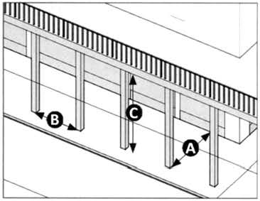
3.26.18.1 Surface parking standards.
The following standards shall be met by transition area:
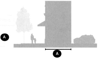
Figure 3. Surface Parking
(1)
Urban Center (T5) and Urban Core (T6) areas:
a.
Parking must not be visible from the adjacent street. Relief may be allowed for building sites with two street frontages at the discretion of the growth management director for the lesser frontage.
b.
Parking must be lined by a minimum habitable space of 30 feet deep, but may be unlined, provided that the minimum building frontage has been met for the particular street frontage.
c.
For unlined portions of a surface parking lot as allowed above, a minimum three-foot streetwall with landscaping fronting it is required, meeting the streetwall standards set forth below.
(2)
General Urban (T4): Parking shall be located in the rear and/or side of the building.
(3)
Neighborhood Transition (T3.5): Parking must be located on the side and/or rear of the building, except when impractical; the growth management director may allow parking in front of the building in such cases.
3.26.18.2 Structured parking garage design.
The following standards shall be met by transition area:
(1)
In Urban Core (T6) areas: Parking garages shall be located internal to the building.
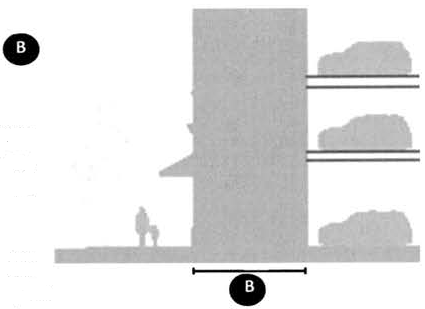
Figure 4. Parking Garage
(2)
In Urban Center (T5) and General Urban (T4):
a.
Parking garages must be lined by a minimum habitable space of 20 feet on the ground floor for parcels 136 feet deep or more (see Figure 4).
b.
For parcels that are 135 feet deep or less, 40 percent of the upper floors may be unlined provided that the openings to the parking garage are detailed and proportioned similar to the habitable floors to appear as fenestration/windows.
c.
Parking garages are prohibited along a street frontage if an alley or other internal and accessible drive is present. If there is only one frontage (without an alley) then a garage entrance and exit may be provided along the street frontage. Parking garage entrances should be located on the lowest ranking street frontage, and designed to minimize points of access.
d.
Each parking garage opening's architectural treatment must have no greater than a maximum width of 12 feet for the opening separated by a minimum of two-foot column or wall.
(3)
In any transition area, the parking garage must provide design elements that complement the primary building.
(4)
Access to the interior of the parking structure must be provided to people walking by the most direct means possible to the street or principal use in a safe, well-lit pathway.
(5)
Ramping must be internalized. Exposed spandrels are prohibited unless architecturally integrated into the overall design of the garage.
(6)
The exterior facades of all parking garages must be designed to achieve architectural unity with the principal structure(s) they are intended to serve. The quality of design, architectural detailing and use of material must be on par with those used in the principal structure.
3.26.18.3 Shared parking.
Overall parking requirements are in article III, division 41, Off-Street Parking. Reductions to the parking requirement are available in Table 1. In addition to the reductions identified in Table 1, shared parking is permitted in the East Town Special Plan, when approved by the growth management director. A project utilizing shared parking may calculate the required parking spaces by using Table 3, Shared Parking Factor. The formula for shared parking is the "use A" parking requirement plus "use B" parking requirement divided by the shared parking factor to arrive at a shared parking requirement. Adjustments and special conditions, such as the prohibition of reserved parking, may be considered by the growth management director during the relevant development review committee process.
Table 3. Shared Parking Factor
(Ord. No. 1827-24, § 2, 10-15-24)
3.26.19 - Streetwall standards.
Streetwalls are intended to increase the continuity of the architectural and aesthetic experience when walking on a street adjacent to a development site, where parking lots and/or lack of building frontage break the overall continuity and urban design of the block.
Table 4. Streetwall Standards
| Type of Screening** | Dimensional requirements | |
|---|---|---|
| Masonry Wall Height (preferred) |
3 ft maximum (if located in front yard)
6 ft maximum side/rear yards | |
| Wrought Iron or Metallic Fence Height |
4 ft maximum
6 ft maximum side/rear yard | |
| Vegetation softens the appearance of masonry walls. Landscaping increases the needed opacity of wrought iron or metallic fences. | ||
| Landscape Setback (planted with shrubs) | 2 ft min - 4 ft max, and behind the front facade of the building * | |
* Streetwalls may be interrupted by parking lot drive aisles if such are allowed by the Land Development Code or growth management director in consultation with the city transportation engineer to provide for circulation that minimizes the number of access points.
** If the front facade of an adjacent building is set back enough to allow for vegetation to be planted in front of the streetwall, then the streetwall may be aligned with the front facade of the building.
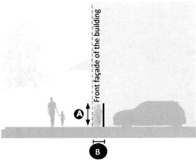
Figure 5. Streetwall
(Ord. No. 1827-24, § 2, 10-15-24)
3.26.20 - Building design standards.
The massing and architectural component requirements set forth herein provide a flexible system for enabling the construction of new buildings and the expansion and modification of existing buildings. This section applies to all buildings, including primary buildings (comprised of a main building mass and components) and accessory buildings (comprised of a primary building, massing components and architectural components).
(Ord. No. 1827-24, § 2, 10-15-24)
3.26.21 - Architectural massing and articulation.
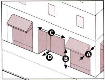
No single building mass or single architectural treatment may be greater than 240 feet in length in "T6: Urban Core" areas; 120 feet in "T5: Urban Center" areas; or 60 feet in "T4: General Urban" areas. Building mass shall be articulated, with architectural materials and detailing modulated to create the appearance of multiple buildings directly adjacent to one another.
(1)
Primary building entrances must be visible and directly accessible from a street. Building massing and architectural treatments must be employed to clearly define and discern the location of building entries from the street.
(2)
All treatments are permitted to be adjacent to each other horizontally, unless otherwise indicated.
(3)
Multiple treatments of the same type may be used more than once, unless otherwise indicated. Treatments of the same type may not attach to each other, subject to the growth management director's review.
(4)
Some treatments standards may encroach small architectural features into the frontage zone, as determined by the growth management director.
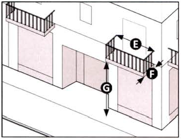
The following facade treatment standards (Figure 6) provide a range of facade types that are acceptable within the district. The intent is to design buildings with at least one, or a combination of treatment to support walkability and visual interest within the East Town Special Plan:
Figure 6. Architectural Treatments
 | FORECOURT | ||
| Forecourts are uncovered courts within a building. They usually result in a u-shaped building footprint in which the forecourt is open toward the street. When a forecourt faces a similar size one across the street it can define a larger open space that provides an occasional interruption of the street wall. A forecourt allows for increased natural light and ventilation. | |||
| Width | 40 ft min | ||
| Depth | 40 ft min | ||
| Height to width ratio | Height should not exceed 2 times the width of the forecourt | ||
| GALLERY | ||
| Galleries provide for a roof or balcony that is supported on columns or posts, which are usually spaced regularly. The posts or columns that support the gallery encroach into the streetscape frontage zone. This frontage type is ideal for retail use when the sidewalk is fully designed within the gallery for complete walkability. Easements may be needed, or a building will be permitted to setback from the right-of-way to provide this frontage. | |||
| Depth | 10 ft min | ||
| Encroachments into the streetscape (subject to approval by the growth management director) | Permitted, posts and columns may not exceed 2 ft depth and 2 ft width and may not be spaced any closer than 8 ft on center | ||
| Height | 12 ft clear min | ||
 | ARCADE | ||
| A colonnade supporting habitable space that overlaps the sidewalk, while the facade at sidewalk level remains at or behind the frontage line. This frontage type is ideal for retail use but only when the streetscape walkway zone is covered within the colonnade so that walkers cannot bypass it. | |||
| Depth | 10 ft min | ||
| Encroachments into the streetscape (subject approval by the growth management director) | 4 floors of habitable space may encroach into the right-of-way above the ground floor. Posts and columns may not exceed 2 ft depth and 3 ft width and may not be spaced any closer than 8 ft on center | ||
| Height | 12 ft clear min | ||
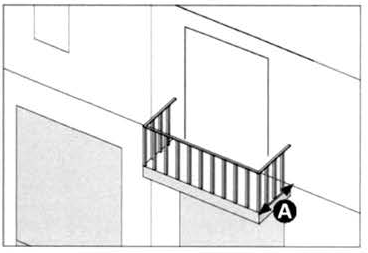 | BALCONY | ||
| Balconies are architectural features that allow for private outdoor space. Balconies are used on upper floors, not ground floors. Balconies may be covered by a roof or balconies on upper floors or may be open to the sky. They may project from the facade of the building and/or may be carved out of the building's facade. | |||
| Depth | 4 ft min | ||
| Encroachments into rights-of-way | prohibited | ||
| Encroachments into the streetscape | 2 ft maximum | ||
 | SHOPFRONT | ||
| Shopfronts are facades placed at or close to the front property line, with the entrance at sidewalk grade. They are conventional for retail frontage. For every frontage that includes a shopfront, shelter for people walking must be provided in the form of an awning, marquee, gallery, arcade or second floor balcony and /or recessed entrance. 50% of the shopfront facade shall be covered by awnings or a marquee. If shelter is provided by a recessed entrance the minimum width of the recessed entrance is 25% of the shopfront facade. | |||
| Sill Height | 3 ft max | ||
| AWNING AND MARQUIS | |||
| Depth | 5 ft min - 8 ft max | ||
| Encroachments into the streetscape (subject to approval by the growth management director) | 8 ft max | ||
| Height | 8 ft min clearance | ||
| Distance from tree trunks | 6 ft min distance from tree trunks | ||
| RECESSED ENTRANCE | |||
| Width | 6 ft min | ||
| Depth | 4 ft min (if the recess is less than 4 ft in depth total shelter should be augmented by an awning) | ||
 | SECOND FLOOR BALCONY(1) | ||
| Shelter for people walking, such as awnings and marquees, may be substituted by a second-floor balcony that provides shelter for the retail entrance or shopfront, provided that the balcony conforms to the following recommended standards: | |||
| Width | 6 ft min | ||
| Depth | 4 ft min | ||
| Encroachments into the streetscape (subject to approval by the growth management director) | 5 ft max | ||
| Height | 15 ft min height clearance or matching second floor level | ||
| (1) If the second-floor balcony is not substituting an awning or a marquee, then the second-floor balcony is not subject to these dimensional standards. | |||
(Ord. No. 1827-24, § 2, 10-15-24)
3.26.22 - Windows and door standards.
Each street-facing floor is required to comply with minimum fenestration and glazing standards, as provided in Table 5, between three and seven feet of the individual floor's elevation. Minimum glazing percentages refer to the proportion (ratio) of glazing to opaque wall within this three to seven-foot area, and each floor is calculated separately per Table 5, as illustrated in Figure 7.
Glazing must have clear or lightly tinted glass with a visible light transmittance factor of 0.6 or higher (where R + A + T = 1.0). Translucent, opaque, and mirrored glass may not be used. First floor glazing must be non-tinted and transparent to permit view of human activities and spaces within. Glass block and similar treatments are not considered transparent and may not count toward the minimum transparency requirement for fenestration and glazing.
Table 5. Minimum Fenestration, Glazing and Base Standards
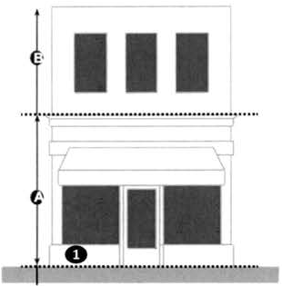
Figure 7. Fenestration, Glazing and Base Standards
(Ord. No. 1827-24, § 2, 10-15-24)
3.26.23 - Landscape standards.
Neighborhood Transition (T3.5) areas shall comply with all of article VIII, Landscaping and Tree Protection, yet the requirements shall be modified within the Urban Core (T6), Urban Center (T5) and General Urban (T4) transition areas as follows:
(1)
Front buffers are met by above streetscape requirements.
(2)
Side yard buffers are not required if adjacent to another transition area, provided street side yard area(s) also comply with the streetscape requirements.
(3)
Rear yard buffers are only required when a parcel is adjacent to a non-transition area(s) at the edge of the East Town Special Plan.
(4)
Landscape screening is required for parking areas, all loading docks, and trash areas from both interior view and from street view; building area(s) may have reduced peripheral landscaping for vehicular use areas. The overall landscape design may be reduced upon review and approval of the growth management director.
(5)
Urban Core (T6) and Urban Center (T5) are exempt from the facade planting requirements, provided the streetscape standards are met.
(Ord. No. 1827-24, § 2, 10-15-24)
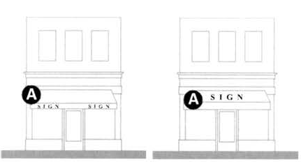
3.26.24 - Sign standards.
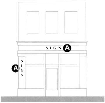
Signage within the East Town Special Plan must comply with the sign standards of this section in addition to the dimensional standards contained in division 42, Sign Regulations, of the Land Development Code. If any sign standards in this document conflict with the citywide sign code, the standards detailed in this document shall take precedent.
Any business or development site that erects more than one exterior sign will be required to submit a sign package that identifies a theme of uniform design elements including color, lettering style, material, and placement. Each business shall have a consistent palette of signs that are designed in a similar character and style.
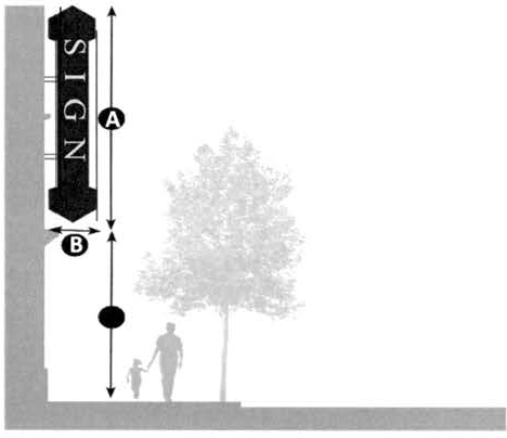
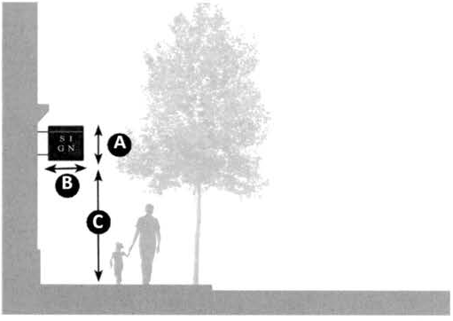
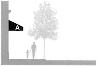
Figure 8. Sign Standards
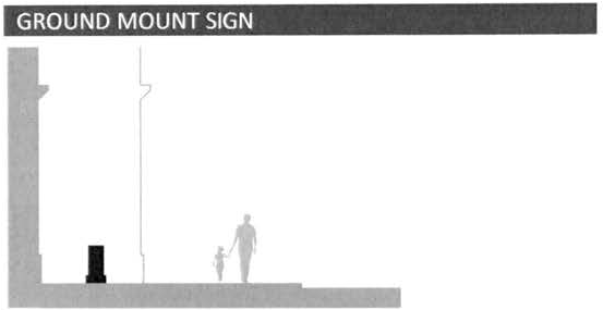
A ground mount sign is permitted when the sign is integrated in a courtyard or park space. The growth management director will review and approve the location of any such sign.
| GROUND PROJECTING SIGN | ||
|---|---|---|
| Grand projecting signs are tall, large, vertically oriented signs that project from the building perpendicular to the facade and are structurally integrated into the building. | ||
| STANDARDS | ||
| Horizontal orientation; perpendicular to facade | Perpendicular to facade | |
| Sign height | 30 ft max. | |
| Sign projection | 6 ft max. (projected from facade of building) | |
| Distance from sidewalk | 12 ft min. | |
| Note: No portion of a grand projecting sign shall extend more than 10 feet above the roofline. | ||
| PROJECTING SIGN | ||
| Projecting signs are cantilevered signs that are structurally affixed to the building and oriented perpendicularly to the building facade. | ||
| STANDARDS | ||
| Horizontal orientation; perpendicular to facade | Perpendicular to facade | |
| Sign height | 4 ft max. | |
| Sign projection | 4 ft max. | |
| Distance from sidewalk | 9 ft min. | |
| Note: Projecting signs shall only be mounted on wall area below the second-floor level. No projecting sign shall exceed 16 square feet in size. | ||
| AWNING PLACEMENT | |
|---|---|
| STANDARDS | |
| Horizontal orientation; perpendicular to facade | |
| Location | |
| MENU BOARD/STREET ART | ||
| STANDARDS | ||
| Horizontal orientation; perpendicular to facade | ||
| Sign max height/width | 5 ft height/3 ft width | |
| Sign lettering | 2—4 inches in height | |
| Location | Frontage zone or furnishing zone | |
| Note: Sign shall be present during store hours only, and must be removed during closing hours. | ||
(Ord. No. 1827-24, § 2, 10-15-24)