
Belton City Zoning Code
CHAPTER 36
SUBDIVISION REGULATIONS
ARTICLE VI. - RESERVED[1]
Editor's note— Ord. No. 2013-3938, § 1, adopted July 23, 2013, repealed the former Art. VI, §§ 36-140—36-142, which pertained to supplemental APWA requirements and standard details and derived from UDC 2010, §§ 20.36, 20.37, 20.39
Sec. 36-1. - Title.
This chapter shall hereafter be known, cited, and referred to as the "Subdivision Regulations of Belton, Missouri."
(UDC 2010, § 20.1)
Sec. 36-2. - Purpose.
These regulations are adopted for the following purposes:
(1)
To protect and provide for the public health, safety, and general welfare of the city.
(2)
To guide the future growth and development of the city, in accordance with the comprehensive plan.
(3)
To provide for adequate light, air, and privacy; to secure safety from fire, flood, and other danger; and to prevent overcrowding of the land and undue congestion of population.
(4)
To protect the character and the social and economic stability of all parts of the city and to encourage the orderly and beneficial development of all parts of the city.
(5)
To protect and conserve the value of land throughout the city and the value of buildings and improvements upon the land, and to minimize the conflicts among the uses of land and buildings.
(6)
To guide public and private policy and action in order to provide adequate and efficient transportation, water, sewerage, schools, parks, playgrounds, recreation, and other public requirements and facilities.
(7)
To provide the most beneficial relationship between the uses of land and buildings and the circulation of traffic throughout the city, having particular regard to the avoidance of congestion in the streets and highways, and the pedestrian traffic movements appropriate to the various uses of land and buildings, and to provide for the proper location and width of streets and building lines.
(8)
To establish reasonable standards of design and procedures for subdivisions and re-subdivisions, in order to further the orderly layout and use of land, and to insure proper legal descriptions and monumenting of subdivided land.
(9)
To insure that public facilities are available and will have a sufficient capacity to serve the proposed subdivision.
(10)
To prevent the pollution of air, streams, and ponds; to assure the adequacy of drainage facilities; to safeguard the water table; and to encourage the wise use and management of natural resources throughout the city in order to preserve the integrity, stability, and beauty of the community and the value of the land.
(11)
To preserve the natural beauty and topography of the city and to ensure appropriate development with regard to these natural features.
(12)
To provide for open spaces through the most efficient design and layout of the land, including the use of average density in providing for minimum width and area of lots, while preserving the density of land as established in this Code.
(UDC 2010, § 20.3)
Sec. 36-3. - Applicability; permits and approvals.
(a)
The owner of any land located within the jurisdiction of these regulations subdividing said land into two or more lots, blocks, tracts or parcels, for the purpose of laying out any subdivisions, suburban lots, building lots, tracts or parcels or any owner of any land establishing any street, alley, park or other property intended for public use or for the use of purchasers or owners of lots, tracts or parcels of land fronting thereon or adjacent thereto, shall cause a plat to be made in accordance with these regulations, unless exempted under section 36-4. A building permit shall not be issued on any lot, tract or parcel not in compliance with these regulations.
(b)
Further, no building permit shall be issued for any new or related principal structure upon a lot or tract of land containing more than 20,000 square feet that has not been lawfully subdivided, split or platted since January 11, 1972. Permits may be issued provided said property is properly subdivided, split or platted according to the subdivision regulations currently in affect at the time of application for said building permit. On lots or tracts containing less than 20,000 square feet the owner shall grant to the city by a deed or other appropriate instrument any required street right-of-way, utility easements for the construction and maintenance of water, gas and sanitary sewer lines; conduits, poles, wires and anchors, and storm drainage channels; and appurtenances to satisfy the subdivision regulations in effect at the time of said application for building permit. However, any structure replacing a principal structure individually destroyed within one year of application may be issued a building permit without complying with the foregoing requirements if same is to be reconstructed on not more than the limits of the existing or original foundation.
(UDC 2010, § 20.2)
Sec. 36-4. - Exemptions.
These regulations shall not apply in the following instances:
(1)
A change in the boundary between adjoining lands which does not create an additional or substandard lot.
(2)
Land used for street or railroad right-of-way, a drainage easement or other public utilities subject to local, state or federal regulations, where no new street or easement of access is involved.
(3)
Any transfer by operation of law.
(4)
A conveyance plat to combine or subdivide any number of parcels of previously unsubdivided land for the purpose of sale or conveyance, subject to the following conditions:
a.
Only tracts shall be created by conveyance plat, and no dedications of public or private easements or rights-of-way shall be granted.
b.
A conveyance plat does not grant any rights to develop or guarantee public utilities, public or private access, or issuance of permits without compliance with all subdivision regulations as approved through a preliminary plat and/or final plat.
c.
A conveyance plat prepared by a licensed surveyor shall be provided to the director for review and approval subject to the following review criteria:
i.
The application involves no adjustments to the layout of existing rights-of-way, easements, or public areas.
ii.
The resulting ownership patterns are consistent with those in the area and does not create landlocked tracts or otherwise difficult to develop tracts.
iii.
The resulting tract or tracts conform to the standards of this Code and would be buildable if final platted or further subdivided.
iv.
The applicant will not create any negative influences on the existing or potential development of the property or adjacent property considering the existing zoning, future land use map, or the goals and strategies of the comprehensive plan.
d.
If the director determines that the application does not meet the applicable review criteria, the applicant may request that the application be referred to the planning commission following the preliminary plat process.
(UDC 2010, § 20.2.1; Ord. No. 2025-4901, § 6 (Exh. D), 3-11-2025)
Sec. 36-5. - Restrictive covenants.
The planning commission shall have the right to confer with the subdivider regarding the maintenance of structures, properties, and improvements, in the subdivision. The planning commission may require that certain minimum regulations regarding this matter be incorporated in the restrictive covenants.
(UDC 2010, § 20.4)
Sec. 36-6. - Plats required.
All plans, plats or re-plats of land laid out in building lots, and the streets, alleys, easements, or other portions of the same intended to be dedicated for public use, or for the use of purchasers or owners of the lots fronting thereon or adjacent thereto, shall be submitted to the planning commission for their approval and to the city council for their official acceptance of dedications. No plat shall hereafter be deemed approved if such dedications are not accepted by the city council.
(UDC 2010, § 20.5)
Sec. 36-7. - Jurisdiction.
These regulations shall apply to all land located within the incorporated area of the city.
(UDC 2010, § 20.6)
Sec. 36-33. - Minor subdivision.
(a)
General. The intent of this section is to provide for the issuance of building permits in lots or parcels divided into not more than three tracts, provided that the resulting lots shall not again be divided without platting in accordance with the preliminary and final plat requirements of these regulations. The planning commission may approve or disapprove minor subdivision in accordance with the following regulations.
(b)
Application procedures. Requests for minor subdivision approval shall be made by the owner of the land to the community development director. Six copies of a scale drawing of the lots involved if there are not structures thereon or, if structures exist, six copies of a survey of the lots and the location of the structures thereon together with the precise nature, location, and dimensions of the proposed minor subdivision shall accompany the application.
(c)
Approval guidelines. The planning commission and city council shall follow the following guidelines in reviewing a minor subdivision:
(1)
No minor subdivision shall be approved if:
a.
It does not comply with the minimum design requirements of these regulations.
b.
A new street or alley is needed or proposed.
c.
A vacation of streets, alleys, setback lines, access control or easements is required or proposed.
d.
If such action will result in significant increases in service requirements (e.g., utilities, schools, traffic control, streets, etc.); or will interfere with maintaining existing service levels (e.g., additional curb cuts, re-paving, etc.).
e.
There is less street right-of-way than required by these regulations or the comprehensive plan unless such dedication can be made by separate instrument.
f.
All easement requirements have not been satisfied.
g.
If such minor subdivision will result in a tract without direct access to a street.
h.
A lot or parcel less than ten acres in area will be created.
i.
If the lot or tract has been previously subdivided in accordance with these regulations.
(2)
The planning commission may make such additional recommendations or requirements as deemed necessary to carryout the intent and purpose of existing land development regulations and governing body policy. Requirements may include, but are not limited to, installation of public facilities, dedication of right-of-way and easements, and submission of covenants for the protection of other landowners in the original subdivision.
(3)
The planning commission shall, in writing, either approve, with or without conditions, or deny the minor subdivision within 60 days of application unless the applicant waives this time requirement.
a.
If approved by the planning commission, and after all conditions have been met, the planning commission shall sign and furnish a certificate of approval to be affixed to the minor subdivision survey and a certified copy thereof shall be filed with the recorder of deeds, the official designated to issue building or occupancy permits, and a copy shall be furnished to the applicant.
b.
If approved with conditions or rejected, the city council shall review and deny or unanimously approve with conditions or unanimously approve the minor subdivision, unless such is withdrawn by the applicant.
(d)
Filing fee. The filing fee for minor subdivision shall be $200.00.
(UDC 2010, § 20.9; Ord. No. 2011-3751, § 1, 9-27-2011; Ord. No. 2018-4436, § 4, 5-15-2018)
Sec. 36-34. - Platting.
(a)
Pre-application: Prior to the filing of a plat, the sub divider shall contact the community development director, the city engineer and any other appropriate city official to determine:
(1)
Procedure for filing plats.
(2)
Availability of public sewer and water systems.
(3)
Requirements for private sewer and water systems.
(4)
Comprehensive Plan requirements for major street, land use, parks, schools, and public open spaces.
(5)
Zoning requirements for the property in question and adjacent properties.
(6)
Special setback requirements for arterial, collector and local streets.
(7)
Specifications for road and other required construction improvements.
(b)
Official submission dates. For the purpose of these regulations, for all types of land subdivision, the date of the regular meeting of the planning commission at which a plat is first considered shall constitute the official submittal date of the plat. The planning commission shall act upon a final plat within 60 days of its submittal, unless this time requirement is waived by the applicant.
(c)
Submission of a preliminary plat. After receiving approval of preliminary sewer and water plans from the city engineer the subdivider may submit a preliminary plat together with any supplementary information necessary to the zoning administrator. The preliminary plat shall contain all contiguous land under the same ownership.
(1)
Filing fee. A filing fee of $200.00 for the first 20 lots plus $10.00 per lot thereafter for residential development and $300.00 for the first 40 acres plus $10.00 per acre thereafter for commercial development shall accompany the filing of each preliminary plat. The preliminary plat shall not be accepted for filing until the filing fee therefore has been paid by the subdivider.
(2)
Number of copies. The subdivider shall submit 16 copies of the preliminary plat and of a vicinity map (if not on the preliminary plat). These plans shall be filed with the zoning administrator at least 14 days prior to a regular meeting of the planning commission at which the preliminary plat is to be considered.
(3)
Reserved.
(4)
Preliminary plats shall contain:
a.
The proposed name of the subdivision. (The name shall not duplicate or too closely resemble the name or names of an existing subdivision.)
b.
The location of the boundary lines of the subdivision and reference to the section or quarter section lines.
c.
The names and addresses of the developer or owner, and the engineer or land surveyor who prepared the plat.
d.
Scale of the plat, one inch equals 100 feet or larger however, the zoning administrator may approve a scale of one inch equals 200 feet if the property is excessively large.
e.
Date of preparation and north arrow.
f.
Location, width and name of platted streets or other public ways, railroads and utility rights-of-way, parks and other public open spaces and permanent buildings within or adjacent to the proposed subdivision.
g.
All existing sewers, water mains, gas mains, culverts, or other underground installations, within or adjacent to the proposed subdivision, with pipe size and manholes, grades and location.
h.
Names of adjacent subdivisions together with arrangement of streets and lots, and owners of adjacent parcels of unsubdivided land.
i.
Topography (unless specifically waived) with contour intervals or not more than two feet, referred to USGS datum; where the ground is too flat for contours, spot elevations at 100-foot distances shall be provided.
j.
Location of watercourses, bridges, wooded areas, lakes, ravines and such other features as may be pertinent to the subdivision.
k.
Current zoning classification.
l.
On subdivisions with more than either five acres (217,800 square feet) or 50 lots, the boundaries and elevations of the 100-year floodplains along drainage ways included in the official Flood Insurance Study (F.I.S.) for Cass County.
m.
The predominant soil types in the subdivision.
n.
The general arrangements of lots and their approximate size and dimensions.
o.
For any lots exceeding 20,000 square feet (0.46 acre) in area, possible lot lines shown in dotted lines, easements and rights-of-way which would provide for re-subdivision into smaller lots.
p.
Front building setback lines.
q.
Location and width of proposed streets, alleys, easements, sidewalks, and pedestrian ways to accommodate local flooding and, along major drainage ways, to accommodate 100-year flooding.
r.
The general plan of sewage disposal, water supply and drainage, including a map showing the drainage area of each major drainage way in which the subdivision is locate.
s.
Location and size of proposed parks, playgrounds, churches, school sites or other special uses of land to be considered for reservation or dedication for public use.
t.
General layout of adjacent property within 185 feet to show how streets and other public facilities in the proposed subdivision relate to the adjacent property.
u.
Approximate gradient of streets.
v.
Stages of development if the total area is not proposed to be developed as a unit.
(d)
Preliminary plat action. Within 60 days after the submission of a preliminary plat and all required information, the planning commission shall approve, conditionally approve, or disapprove the preliminary plat; otherwise the plat is deemed approved by the commission except that the commission with the consent of the applicant, may extend the 60-day period. Action by the planning commission shall be conveyed to the subdivider in writing within ten days after the meeting at which time the plat was considered. In case the plat is conditionally approved or rejected by the planning commission, the subdivider shall be notified of the reason for such action and what requirements shall be necessary to meet the approval of the planning commission. The approval of the preliminary plat does not constitute an acceptance of the subdivision, but is deemed to be an authorization to proceed with the preparation of the final plat.
(e)
Expiration of preliminary plat. The approval of the preliminary plat shall be effective for two years, except that prior to this application date the planning commission may, at the request of the property owner, grant an extension to the validity of the preliminary plat for up to a six-month period at any time. If the final plat for any part of the area covered by the preliminary plat has not been submitted for approval within this specified period a preliminary plat must be resubmitted to the planning commission for approval. If a final plat is approved and filed for any part of the area covered by the preliminary plat, such preliminary plat shall be effective for a period of six years from its approval date.
(UDC 2010, § 20.10; Ord. No. 2011-3751, § 1, 9-27-2011; Ord. No. 2018-4436, § 4, 5-15-2018)
Sec. 36-35. - Final plat.
(a)
Submission.
(1)
Final plat review. A filing fee of $200.00 for the first 20 lots plus $10.00 per lot thereafter for residential development and $300.000 for the first 40 acres plus $10.00 per acre thereafter for commercial development.
(2)
After approval of the preliminary plat, the subdivider may submit a final plat.
(3)
Sixteen copies shall be submitted to the community development director at least seven days prior to the planning commission public meeting.
(4)
The names and signatures of the owner or owners of the property duly acknowledged and notarized shall appear on the original copies submitted.
(5)
The final plat, prepare for recording purposes by a licensed land surveyor, shall be drawn at a scale of at least one inch equals 100 feet, however, the community development director may approve a scale of one inch equals 200 feet if the property is excessively large. The size of the sheet on which such final plat is prepared shall be 36 inches by 24 inches. Where the proposed plat is of unusual size, the final plat shall be submitted on two or more sheets of the same dimensions. If two or more sheets are required, an index map of the same dimensions shall be filed showing the entire development at a smaller scale.
(b)
Information. Final plats shall contain:
(1)
Name of subdivision (not to duplicate or too closely resemble the name of any existing subdivision).
(2)
Location of section, township, range, county and state, including the descriptive boundaries of the subdivision based on an accurate traverse, giving angular and linear dimensions which must be mathematically correct. The allowable error of closing on any portion of the plat shall be one foot in 5,000.
(3)
The location of existing monuments or bench marks shall be shown and described on the final plat. Location of such monument shall be shown in reference to existing official monuments or the nearest established street lines, including the true angles and distances to such reference points or monuments.
(4)
The location of lots, streets, public highways, alleys, parks and other features, with accurate dimensions in feet and decimals of feet with the length of radii on all curves, and other information necessary to reproduce the plat on the ground. Dimensions shall be shown from all curbs to lot lines.
(5)
Lot numbers and block numbers or letters clearly shown in the center of the block.
(6)
The exact locations, widths and names of all streets and alleys and locations, widths and purposes of all easements to be dedicated.
(7)
Boundary lines and description of the boundary lines of any area other than streets and alleys which are to be dedicated or reserved for public use.
(8)
Building setback lines along the front and side lot lines where abutting streets with dimensions.
(9)
On subdivisions with more than five acres (217,800 square feet) or 50 lots, the boundaries and flood elevations of the 100-year flood plains along all drainage ways designated on the official flood insurance study (FIS) for the county.
(10)
Name, signature and seal of the licensed engineer preparing the plat or the professional land surveyor preparing the plat and conducting the survey.
(11)
Scale of the plat (scale to be shown graphically and in feet per plat scale inch), date of preparation and north point.
(12)
Statement dedicating all easements, streets, alleys, and all other public areas not previously dedicated.
(13)
Proof that all property taxes on said land are paid or that assurances of payment are guaranteed with the filing of the final plat.
(14)
The following certificates, which may be combined where appropriate:
a.
A certificate signed and acknowledged by all parties having any record, title, or interest in the land subdivided, and consented to the preparation and recording of said subdivision map.
b.
A certificate signed and acknowledged as above, dedicating or reserving all parcels of land shown on the final plat and intended for any public or private use including easements, and those parcels which are intended for the exclusive use of the lot owners of the subdivision, their licensees, visitors, tenants, and servants.
c.
A certificate signed by the registered land surveyor responsible for the survey and final map, to read as follows:
I HEREBY CERTIFY; that the within plat of (name) ___________ subdivision is based on an actual survey meets or exceeds the current Minimum Standards for Property Boundary Surveys as adopted by the Missouri Board of Architects, Professional Engineers and Land Surveyors of the State of Missouri. I further certify that the bearings shown on this plat are based on (describe bearing reference system along with the method of obtaining the bearing reference) ___________ that the section and sectional subdivision corner monuments and survey boundary corner monuments were either found or set as indicated on this plat; that the lot corners and street centerlines have been marked with permanent monumentation as indicated on this plat; that I have complied with all State and Belton statutes, ordinances and regulations governing the practice of surveying and the platting of subdivision to the best of my professional knowledge and belief.
d.
The acknowledgment of a notary in the following form:
State of ________, County of ________, SS.
Be it remembered that on this _______ day of ___________, 20___, before me, a notary public in and for said County and State, came ___________ to me personally known to be the same person who executed the foregoing instrument of writing and duly acknowledged the execution of same. In testimony whereof, I have hereunto set my hand and affixed my notary seal the day and year above written.
My Commission Expires:___________
e.
The certificate of the planning commission in the following form:
This plat of ___________ has been submitted to and approved by the Belton Planning Commission this ___ day of ________, 19___.
___________
Chairman
___________
Secretary
f.
The acceptance of easements and rights-of-way by the city council in the following form:
These easements and rights-of-way accepted by the city council of Belton, Missouri, this ___ day of ________, 19___.
ATTEST:
1.
A blank space for noting entry on the transfer record in the following form:
Entered on transfer record this ___ day of ________, 19___.
(15)
A note shall be placed on the face of all final plats which states that areas designated as drainage easements shall be maintained by the property owner. In addition, a note shall be placed on the deed of each of the lots possessing a drainage easement that covers an area greater than 1,500 square feet of the lot, which states that the property owner shall be responsible for vegetation control of this drainage easement.
(c)
Final plat action. Within 60 days after the submission of a final plat and all required information, the planning commission shall recommend approval, conditional approval, or denial of the final plat; otherwise the plat is deemed approved by the planning commission except that the planning commission with the consent of the applicant may extend the 60-day period. Action by the planning commission shall be conveyed to the subdivider in writing within ten days after the meeting at which time the plat was considered. In case the plat is conditionally approved or rejected by the planning commission, the subdivider shall be notified of the reason for such action and what requirements shall be necessary to meet the approval of the planning commission.
(UDC 2010, § 20.12; Ord. No. 2011-3751, § 1, 9-27-2011; Ord. No. 2017-4400, § 1, 12-12-2017)
Sec. 36-36. - Recording of the final plat.
(a)
No plat may be recorded or filed with the county recorder of deeds until such plat has been approved by the city council; all dedications of rights-of-way, easements and other property have been accepted by the city council; and the design and financing of all improvements has been agreed to by both the subdivider and the city council. The financial responsibility for the cost of recording the plat with the recorder of deeds will be borne solely by the subdivider.
(b)
Within 15 days of recordation of the final plat, the subdivider must submit a minimum of four copies of the final plat, of which to the community development director, along with a recorded copy of the development agreement, declaration of covenants and restrictions and articles of incorporation establishing a property owners association if required by this Code. No building permit shall be issued until the final plat is approved by the city council.
(c)
The approved plat shall be recorded at the county recorder of deeds' office at the subdivider's expense.
(UDC 2010, § 20.13; Ord. No. 2011-3751, § 1, 9-27-2011; Ord. No. 2017-4400, § 1, 12-12-2017)
Sec. 36-37. - Effect of failure to timely record plat.
If a final plat is not recorded within one year of the date of the governing body's approval of the final plat, the approval shall become null and void and a new final plat must be submitted to the planning commission and the governing body for their consideration. No building shall be occupied until the final plat has been recorded with the county recorder's office.
(UDC 2010, § 20.13.1; Ord. No. 2011-3751, § 1, 9-27-2011)
Sec. 36-38. - Property owner's association.
(a)
Establishment. If a property owners association is to be responsible for the maintenance and control of roads, open space, recreational facilities or other common areas and facilities within a subdivision, that association must have legal authority to maintain and exercise control over the common areas and facilities, including the power to compel contributions from residents or property owners to cover their proportionate share of the costs associated with the maintenance of the common areas and facilities.
(b)
Documentation.
(1)
Documents providing for the establishment of a property owners association must be submitted to the community development director before approval of a final plat.
(2)
The city's review is limited to ensuring that the property owners association has clear legal authority to maintain and exercise control over the common areas and facilities, including the power to compel contributions from residents and property owners to cover their proportionate share of the costs associated with the maintenance of the common areas and facilities.
(c)
Responsibilities. Property owners associations must be established and approved as a condition of plat or development approval. They are responsible for the cost and maintenance of all common open space, private streets, landscape areas (including those within cul-de-sac islands, and around identification signs), trails, subdivision identification signs, utilities and other facilities that are not dedicated to the public.
(UDC 2010, § 20.14)
Sec. 36-65. - Design criteria and construction standards.
All improvements to public infrastructure shall be in accordance with the design criteria, construction standard specifications, and standard details provided in the city's design and construction manual. This manual is accessible online at the following address:
http://www.belton.org/index.aspx?nid=423
(UDC 2010, § 20.15; Ord. No. 2006-3267, 7-25-2006; Ord. No. 2008-3419, 2-12-2008; Ord. No. 2013-3938, § 1, 7-23-2013)
Sec. 36-66. - Blocks.
(a)
Length. Intersecting streets (which determine block length) shall be provided at such intervals as to serve cross traffic adequately and to meet existing streets in the neighborhood. In residential districts the blocks shall not exceed 1,320 feet in length, except that a greater length may be permitted where topography or other conditions justify a departure from this maximum. In blocks longer than 800 feet (0.15 mile), pedestrian ways and/or easements through the block may be required near the center of the block. Such pedestrian ways or easements shall have a minimum width of ten feet.
(b)
Width. In residential development, the block width shall normally be sufficient to allow two tiers of lots of appropriate depth. In certain instances, however, a different arrangement may be required in order to provide better circulation or to protect a major circulation route. Blocks intended for business or industrial use shall be of such width and depth as may be considered most suitable for the prospective use.
(UDC 2010, § 20.16)
Sec. 36-67. - Lots.
(a)
Minimum lot width shall be measured at the required building setback line; however, in no case shall the lot width be less than that required by the zoning district in which the lot is located. Further, the lot width at the front property line of any lot shall be at least 38 feet. In addition, corner lots should have a width 15 feet greater than the minimum width.
(b)
Minimum lot depth shall be 120 feet. (Said measurement shall be made through the center of the lot and shall be perpendicular to the property line or radial to the property line on curved streets.)
(c)
The maximum depth of residential lots shall not exceed 2½ times the width thereof, except where the lots are intended for single-family attached dwellings, such as townhouses, in which case the depth shall not exceed four times the width.
(d)
Minimum lot area shall be subject to the requirements of the zoning district in which the subdivision is located. The more restrictive of the regulations shall govern. Residential lots not served by a community or public sewage disposal system shall have a lot area as may be determined to be necessary by the commission to adequately accommodate proposed private individual or shared sewage systems.
(e)
The minimum lot area of residential lots proposed to be served by individual private wells shall be as determined by the health department in accordance with the factors of soil conditions and the proposed sewage disposal system.
(f)
Remnants of land containing less area than herein required, and not designated and accepted for utility of public purposes, shall not be permitted.
(g)
All side lot lines shall bear between 60 and 90 degrees from the street right-of-way line on a straight street or from the tangent of a curved street.
(h)
Front building or setback lines shall be shown on the final plat for all lots in the subdivision and shall not be less than the setback requirements of the zoning district in which the lots are located.
(i)
Double frontage lots shall be avoided unless, in the opinion of the planning commission, a variation to this rule will give better street alignment and lot arrangement.
(j)
Every lot shall abut on a public street other than an alley, unless on a private street that has been approved as part of a planned unit development.
(k)
The subdivision or re-subdivision of a tract or lot shall not be permitted where said subdivision or re-subdivision places an existing permanent structure in further violation of the requirements of the zoning district in which the tract or lot is located, or the minimum design standards of these regulations.
(l)
Residential lots shall not face on arterial streets. The number of lots facing on collector streets shall be kept to a minimum in each subdivision. The street pattern shall be designed so that the sidelines of lots abut collector streets wherever land shapes and topography permit.
(m)
No lot shall have an average grade lower than the street on which it fronts unless a detailed grading plan which verifies that buildable areas will be protected from stormwater runoff is submitted and approved by the city engineer. Average grade shall be the medium elevation of the front and rear of the lot.
(n)
Yard matching. The rear yard widths of the proposed development shall match the rear yard widths of the existing adjacent development.
(o)
Building lines. A side yard building line on the side of a corner lot abutting the street shall be shown in accordance with the requirements of the zoning district in which the lot is located.
(UDC 2010, § 20.18; Ord. No. 2002-2913, 8-2002; Ord. No. 2013-3938, § 1, 7-23-2013)
Editor's note— Ord. No. 2013-3938, § 1, adopted July 23, 2013, deleted former § 36-67 from the Code and renumbered subsequent sections accordingly. The former § 36-67 pertained to streets and alleys and derived from UDC 2010, § 20.17; Ord. No. 2006-3267, adopted July 26, 2006.
Sec. 36-68. - Easements.
Where alleys are not provided, permanent easements of not less than 7½ feet in width shall be provided on each side of all rear lot lines, and 7½ feet on side lot lines where necessary, for utility poles, wires, conduits, underground conductors, storm and sanitary sewers, gas, water and heat mains, and other public utilities. These easements shall provide for a continuous right-of-way. Where the utility company or agency has the need for a wider easement than required in this section for a specific location, this easement may be required to be shown on the plat. Permanent easements shall not be obstructed by structures, retaining walls or trees. A property owner may install fences, except not in drainage easements, and landscape the easement with grass and shrubs at their own risk. Property owners shall be responsible for the maintenance of all easements on their property. A 12-foot temporary construction easement shall be provided on each side of all lot lines for initial construction of water, sewer and other utility lines.
(1)
Utility easements. The director of public works may require general utility easements of adequate width along lot lines where necessary or advisable for poles, wires, conduits, sanitary sewers, gas, water, power, and other utility lines as dictated by the plans of the developer to provide utility connections. The following are established as minimum width for any general utility easements on all lots:
a.
Front line easements: ten feet;
b.
Side line easements: seven feet five inches or 15 feet total;
c.
Rear line easements: 7½ feet if adjacent to a general utility easement of at least five feet in width otherwise, ten feet;
d.
Prior to placement of utility appurtenances, staff approval is required.
(2)
Drainage easements.
a.
Suitable drainage easements as required by the director of public works must be dedicated on the subdivision plat to provide for the natural drainage of stormwater through the plat and in consideration of proposed improvements.
b.
The minimum width for drainage easements shall not be less than 15 feet for closed conduits and 20 feet for open channels, but, in any case, must provide for conveyance of a 100-year storm flow with additional width of not less than ten feet for construction and maintenance equipment and operations. Any variations to these standards should be noted on the final plat certified by the director of public works.
c.
These drainage ways must be improved to the extent necessary to properly accommodate storm flows in a manner to eliminate erosion and possible loss and damage to life, land and property. The location, width and alignment of such drainage easements and the improvements shall be subject to the approval of the director of public works.
d.
Topographic preservation easements. If green ways or drainage ways influenced by topographical features such as streams or ponds, ravines, wooded areas or other natural features are to be provided within the proposed plat, their width and location shall be determined as may be necessary to preserve such features.
e.
Buffer strips.
1.
Whenever a proposed residential subdivision contains lots that back onto an arterial or major collector, a buffer strip must be provided, according to one of the following two options:
2.
All trees and shrubs must be set back from the right-of-way line at least five feet.
3.
The buffer may not be a part of the platted lots and must have the following restriction lettered on the plat:
"This buffer reserved for the planting of trees or shrubs by developer; the building of structures and fences hereon is prohibited."
4.
At the time of final plat, the developer must provide a landscape plan for the buffer strip area.
5.
A wall or fence consisting of a unified and consistent design and materials may be installed within the buffer area. The wall or fence must be included in the landscape plan submitted to the planning commission.
(UDC 2010, § 20.19; Ord. No. 2013-3938, § 1, 7-23-2013)
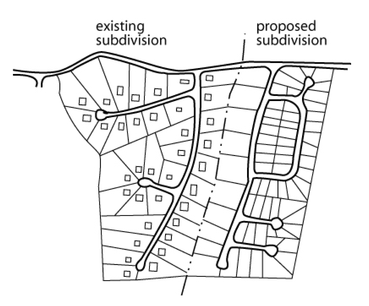
Sec. 36-69. - Subdivision design.
(a)
Access control.
(1)
In the interest of public safety and for the preservation of the traffic-carrying capacity of the street system, the planning commission shall have the right to restrict and regulate points or access to all property from the public street system. Such restrictions shall be indicated on the final plat.
(2)
The design of the subdivision shall provide for efficient traffic flow, proper mixing of land uses, and a logical link between surrounding, and existing development and the proposed layout. The comprehensive plan should be used as a guide in determining if the design of the proposed subdivision is proper. The planning commission shall have the authority to deny a plat or request redesign, if, in its opinion, the layout is not suitable for the site, or if the development of the subdivision would be premature because of inadequate road access or utilities to the proposed subdivision.
(b)
Stormwater runoff plan.
(1)
Design criteria.
a.
All new development and redevelopment projects that disturb greater than or equal to one acre, including projects less than on acre that are part of a larger common plan of development or sale shall include best management practices (BMPs) intended to minimize water quality impacts, and attempt to maintain pre-development runoff conditions. A copy of the MDNR land disturbance permit shall be provided to the city prior to any land disturbance activities.
b.
In addition, whenever existing downstream stormwater facilities are inadequate to carry stormwater runoff, the developer will be required to build detention facilities. The maximum allowable release rate (MARR) for stormwater runoff originating within the proposed development shall not exceed the pre-developed runoff from the site.
c.
The downstream capacities and flows shall be checked at the most critical points as determined by the city engineer, and the most restrictive shall apply. Connection to downstream storm sewer must be approved by the city engineer.
d.
All detention facilities and stormwater BMPs shall be designed in accordance to section 5600, APWA Standard Specifications and Design Criteria and the MARC/APWA "Manual of Best Management Practices For Stormwater Quality." In addition to these design criteria, the following supplemental design criteria shall be used in the design of detention facilities:
1.
The interior of all dry detention facilities shall be sloped at a minimum 1.0 percent grade toward the pilot channel or outlet.
2.
All dry detention facilities serving an area greater than five acres shall be equipped with a two-stage outlet structure, plus an emergency spillway. The outlet structure shall be designed so that the discharge through the first stage accounts for no greater than 20 percent of the total design storm discharge.
3.
Detention facilities serving more than one lot with the potential for multiple users shall be provided a separate lot owned jointly by the lots served through a homeowners association or other agreement. Maintenance shall be provided per subsection (b)(3) of this section unless otherwise provided on the plat.
4.
Detention requirements may be waived if the increase in design storm peak runoff for a given development is less than 5.0 cfs from pre-developed conditions.
5.
Provide five years sediment storage in both wet detention facilities and dry detention facilities. Sediment accumulation shall be calculated per APWA design standards.
6.
Each proposed subdivision or commercial development shall have the following:
(i)
Drainage map using two-foot contour intervals, show all creeks, drainage ways, inlets, pipes, manholes, culverts, bridges, roads and buildings.
(ii)
Drainage map must include all adjacent watersheds that flow through or near the projects site.
(iii)
Hydraulic grade line must be shown for each enclosed storm drainage system or pipe.
(iv)
Curb inlet, field inlet, gutter spread and pipe capacity charts shall be included in the storm drainage improvement plans.
(v)
For flows or runoff greater than 3.0 cfs, field inlets or area inlets shall be required in rear or side yards to reduce flooding of adjacent properties.
(vi)
A storm drainage report based on APWA 5600 and City of Belton Standards shall be submitted and approved prior to completion of storm drainage plans. This report shall include a discussion of proposed and existing runoff conditions of the site, capacity of downstream sewer, proposed storm sewer improvements and detention/retention ponds. A review of drainage areas that are adjacent or that flow through the proposed site must be included.
7.
The city engineer may require that detention/retention basins that flow into adjacent properties meet one or all the following requirement:
(i)
A reduction in outfall release rate and velocity to reduce erosion.
(ii)
Letters of agreement signed by adjacent property owners.
(iii)
Indemnification agreement that indemnifies the city from damages due to runoff, erosive velocities or flood damage to property owners.
(2)
Landscaping requirements.
a.
A landscaping plan for detention facilities in conformance with requirements of this section shall be submitted for approval as part of the preliminary plat for any development.
b.
Detention facilities shall be seeded with a seed mix commonly known as "Red Top" Bluegrass.
c.
Detention facilities shall include landscaping with trees located within five feet of the top of the slope on the perimeter. Trees shall be in good condition with a minimum size of 2.0 caliper. Selection of species and permitted spacing shall conform to the following:
d.
Landscaping requirements shall not apply to parking lot or rooftop detention facilities or permanent wet pond facilities. Trees shall be omitted in locations designated by the city engineer in which installation of such trees represent a hazard condition by root intrusion into embankment area.
(3)
Maintenance.
a.
Stormwater facilities shall be maintained by the owner or other responsible party as outlined in a maintenance agreement approved by the city council at the time of final plat approval.
b.
Disposal of waste from maintenance of facilities shall be constructed in accordance with applicable federal, state and local laws and regulations.
c.
Records of the installation and maintenance and repair shall be retained by the owner or other responsible party for the current five-year period and shall be made available to the city public works department upon request.
d.
Any failure to maintain a stormwater facility in accordance with city requirements or to correct problems with stormwater facility as required by the city after receipt of due notice shall be handled under the procedure for nuisances as outlined in the Belton City Code.
(4)
Stormwater conveyance.
a.
Enclosed systems. Enclosed systems consisting of underground pipes, culverts, and similar functional underground structures shall be used to convey stormwater at all locations within 60 feet of the closest boundary of any existing or proposed habitable building, unless no substantial risk of flooding or other damage is evident and the location is specifically approved by the city engineer.
b.
Open systems. Open systems consisting of natural or improved open channels with intermittent culverts or bridges crossing streets and other surfaced areas may be used to convey stormwater at all locations where the use of an enclosed system is not required by the foregoing criteria.
1.
Special provisions. Maximum Side slopes for open channels shall be three horizontal to one vertical (3:1). Slopes greater than 3:1 shall be allowed only for paved concrete or gabion lining materials and shall require installation of a four-foot-high chainlink fence at the channel perimeter.
(c)
Flooding.
(1)
All subdivision proposals shall be consistent with the need to minimize flood damage.
(2)
All subdivision proposals shall have public utilities and facilities such as sewer, gas, electrical, and water systems located and constructed to minimize flood damage.
(3)
All subdivision proposals shall have adequate drainage provided to reduce exposure to flood hazards.
(d)
Water bodies and watercourses. If a tract being subdivided contains a water body, or portion thereof, lot lines shall be so drawn as to distribute the entire ownership of the water body among the adjacent lots. The planning commission may approve an alternative plan whereby the ownership of and responsibility for safe maintenance of the water body is so placed that it will not become a city responsibility. No more than 25 percent of the minimum area of a lot required under the zoning ordinance may be satisfied by land which is under water. Where a watercourse separates the buildable area of a lot from the street by which it has access, provisions shall be made for installation of a culvert or other structure, when the design is approved by the city engineer.
(e)
Environmental restrictions. No lot shall be impractical to improve due to steepness of terrain, dangerous soil conditions nor other adverse natural physical conditions, or shall any lot be platted to allow development which will constitute a danger to health or safety or result in property destruction.
(f)
Dams. Where dams are proposed in any subdivision, they shall be designed by professional engineers registered in the state. A preliminary engineering report including soil investigations and design and construction procedures shall be submitted with the preliminary plat. When a dam is planned on private property, the engineer shall certify that the dam is constructed in accordance with the approved plans and specifications. Dams shall be designed, approved and permitted based on the latest requirements from the state department of natural resources.
(UDC 2010, § 20.20; Ord. No. 2008-3419, 2-12-2008; Ord. No. 2012-3823, § 1, 8-14-2012; Ord. No. 2013-3938, § 1, 7-23-2013)
Sec. 36-70. - Solar access.
(a)
In order to promote the conservation of energy through the use of both passive and active solar systems, streets in residential subdivisions should, where possible, have an east-west alignment. Lots intended for detached dwellings should be of sufficient width to allow the structure to be built with its longest axis running east-west.
(b)
In order to allow the orientation of structures on the site so as to maximize potential solar gain, side lot lines should run as near to north-south as possible providing that the angle between the side lot line and the street right-of-way line on a straight street or the tangent to a curved street shall be 60 to 90 degrees.
(c)
Definitions. The following words, terms and phrases, when used in this section, shall have the meanings ascribed to them in this subsection, except where the context clearly indicates a different meaning:
Small wind energy system means a wind energy conversion system consisting of a wind turbine, a tower, and associated control or conversion electronics, which has a rated capacity of not more than 100kw and which is intended to primarily reduce on-site consumption of utility power.
Tower height means the height above grade of the fixed portion of the tower, excluding the wind turbine itself.
(d)
Permitted use. Small wind energy systems shall be a permitted use in all zoning classifications where structures of any sort are allowed; subject to certain requirements as set forth below:
(1)
Tower height. For property sizes between one-half acre and one acre the tower height shall be limited to 80 feet. For property sizes of one acre or more, there is no limitation on tower height, except as imposed by FAA regulations.
(2)
Setback. No part of the wind system structure, including guy wire anchors, may extend closer than ten feet to the property boundaries of the installation site.
(3)
Noise. Small wind energy systems shall not exceed 60 dba, as measured at the closest neighboring inhabited dwelling. The level, however, may be exceeded during short-term events such as utility outages and/or severe wind storms.
(4)
Approved wind turbines. Small wind turbines must have been approved under the Emerging Technologies program of the California Energy Commission or any other small wind certification program recognized by the American Wind Energy Association (AWEA).
(5)
Compliance with Uniform Building Code. Building permit applications for small wind energy systems shall be accompanied by standard drawings of the wind turbine structure, including the tower, base, and footings. An engineering analysis of the tower showing compliance with the Uniform Building Code and certified by a licensed professional engineer shall also be submitted. This analysis is frequently supplied by the manufacturer. Wet stamps shall not be required.
(6)
Compliance with National Electrical Code. Building permit applications for small wind energy systems shall be accompanied by a line drawing of the electrical components in sufficient detail to allow for a determination that the manner of installation conforms to the NEC. This information is frequently supplied by the manufacturer.
(7)
Utility notification. No small wind energy system shall be installed until evidence has been given that the utility company has been informed of the customer's intent to install an interconnected customer-owned generator. Off-grid systems shall be exempt from this requirement.
(UDC 2010, § 20.21; Ord. No. 2013-3938, § 1, 7-23-2013)
Sec. 36-71. - Dedication or reservation of public areas, park land and open space.
(a)
Purpose. It is the purpose of this section to:
(1)
Define the obligation of developers to meet the park and open space needs generated by new development;
(2)
Encourage the provision of adequate park and open space in higher density developments through a graduated scale for park land dedication;
(3)
Encourage the inclusion of neighborhood parks within larger residential developments in an effort to achieve a parkland goal of 100 percent service area coverage of all areas within the city limits;
(4)
Encourage the development of larger neighborhood and regional parks by encouraging cash payment in lieu of parkland dedication in smaller residential developments. These cash payments will be applied to the acquisition of larger parks serving multiple neighborhoods within the impact area of the proposed development; and
(5)
Require the development of a linkage system throughout the city.
(b)
Applicability. The provisions of this section apply to all new subdividing and platting activities.
(c)
Community open space network/trails.
(1)
Developments planned for land on which a trail segment is identified on the Growth Management Plan Update Open Space Corridor Plan must provide such trail segment. Trail segments with a minimum width of ten feet shall be constructed at the time of infrastructure improvement and must be constructed to meet or exceed the standards set forth by the Metro Green Plan adopted by the Mid-America Regional Council. A public access easement 15 feet in width is required over the entire length of the trail segment. The property owners' association established for the development must maintain the trails along with all other common areas in their development.
(2)
The trail system is considered integral to the parks and recreation system and all developers required to construct a segment of a required trail will be awarded credit against the land dedication requirement. The developer will be awarded credit both for the property acreage within the public access easement and for the cost of the trail improvement. Trail construction cost credits will be determined by the director of public works using AASHTO standard costs for asphalt installation for the year in which the construction takes place.
(d)
Form of dedication. It shall be a condition of preliminary plat and final plat approval of a subdivision, PUD (planned unit development) or other residential property improvement that each subdivider, developer or owner will be required to make, at the discretion of the parks and recreation board either:
(1)
A land donation;
(2)
Cash in lieu of land donation; or
(3)
A combination of both.
The method selected will be recommended by the parks and recreation board. The planning commission shall review the method selected according to this chapter and Unified Development Code as well as the growth management plan in their regular manner of consideration. The final approval shall be by the city council prior to acceptance of the preliminary plat of the subdivision. All final plats submitted shall incorporate any park land dedication requirement approved as part of the preliminary plat. This provision applies to the development of all lands in the city, including all subdivisions, lots, tracts and parcels of land regardless of intended use.
(e)
Formula for park land dedication. If dedication of land is selected, the dedication shall be by plat and deed. The amount of dedication required shall correspond to the density of the subdivision and shall be calculated off of the following formula:
DLR = DU x D x 0.02
DLR = Dedicated land requirement
DU = Number of dwelling units
D = Number of people per dwelling unit per most recent U.S. Census figures for Cass County.
0.02 = Required acres per person based on 20 acres per 1,000 people.
The method selected will be recommended by the parks and recreation board. The planning commission shall review the method selected according to this chapter and this Unified Development Code. The final approval shall be by the city council prior to acceptance of the preliminary plat of the subdivision. All final plats submitted shall incorporate any park land dedication requirement approved as part of the preliminary plat. This provision applies to the development of all lands in the city, including all subdivisions, lots, tracts and parcels of land regardless of intended use.
(f)
Suitability criteria. All designated open space, parks or recreational facilities must be of suitable size, location, dimension, topography and general character and shall have proper road and/or pedestrian access, as may be appropriate, to be usable open space, as follows:
(1)
The minimum land area for a dedicated parkland tract shall be five acres. Park land shall be in a single parcel unless there are physical features, such as a railroad or water, separating the proposed tracts provided that neither tract is smaller than five acres. Two or more tracts may be considered for subdivisions including at least 500 dwelling units, provided that neither tract is smaller than eight acres.
(2)
Retention areas or detention basins which are required as by the Unified Development Code will not qualify as a public open space.
(3)
Water (including streams, rivers, ponds and lakes), marsh, floodplains and wetland acreages shall not be used to comply with the land requirement of this section, except as provided for required trail improvements listed in this section.
(4)
At least 50 percent of the gross area of any active open space required to be dedicated pursuant to this section shall have a natural slope of four percent or less and shall not be located in an existing watercourse, drainage easement or water ponding area. In addition, that portion of the land must have a cover of six inches or more of topsoil suitable for the seeding and cultivation of grass. If land proposed to be dedicated has a natural slope in excess of that required by this subsection, but may be engineered to provide for a slope that meet the requirements imposed therein, the developer may, upon the favorable recommendation of the parks and recreation board, permit such land to be dedicated to satisfy the requirements of this subsection.
(5)
Open space areas located in spillways where the spillway is greater than 25 percent of the land area shall not be used to meet the requirements of this section. Parkland shall be dedicated by the developer in a condition ready for full service with electrical, water and sewer access at the property line.
(6)
The layout of the park shall maximize street frontage on a public street. Minimum frontage shall be 200 feet.
(7)
All land to be dedicated to the city for park purposes shall have the prior approval of the parks and recreation board and shall be shown and marked on the plat as "dedicated to the City of Belton, Missouri, for park purposes". All land dedicated shall transfer ownership at the time of plat recording.
(g)
Privately dedicated recreation space. The developer may comply with the provisions of this section to furnish land for recreational purposes by privately dedicating recreational open space and/or preserving significant natural, cultural or historic features or landmarks under the following provisions.
(1)
The developer must provide an area that meets the minimum standards set forth in this section related to size, suitability and location.
(2)
The developer must provide minimum neighborhood park improvements in a privately dedicated open space tract including, but not limited to:
a.
Family picnic shelter.
b.
Children's playground.
c.
Turfed playfields.
(3)
All improvements to privately dedicated open space tracts shall be included in the first phase of infrastructure installation for the development's first final plat. A public access easement over the entire area is required and must be shown on the final plat of the phase of development which includes the dedicated space.
(4)
Privately dedicated parkland shall be maintained by the developer or the lot owners in the subdivision under a legal agreement approved by the city as adequate to ensure its continued operation and maintenance.
(5)
The parks board shall recommend credit against the requirements of this section for privately dedicated parkland upon a finding that the dedication would advance the goals of the parks and recreation element of the city's most recent comprehensive plan and/or would preserve a significant natural, cultural or historic feature or landmark. All requests shall be submitted to the parks and recreation department two weeks prior to appearance before the parks board and shall include the following information:
a.
A site plan showing:
1.
Scale of the drawing and the boundaries, dimensions and orientation of the site to true north;
2.
Topography at a minimum two foot contour interval;
3.
Location and layout of existing physical characteristics (vegetation, natural waterways and drainage ways, rock outcroppings, etc.) indicating any significant features to be removed, improved or preserved;
4.
Location and layout of proposed improvements including landscaping, irrigation system, pathways and trails, play areas and playground equipment, lighting, fencing, structures, etc.;
5.
Ingress, egress and internal circulation for the site; and relationship of the proposed site and proposed improvements to adjoining property.
b.
An itemized list of the proposed improvements including a description, the quantity and estimated per unit cost figure for the individual improvements.
c.
A statement of the methods and/or provision for ownership, maintenance and use of the site and proposed improvements.
d.
Any materials and/or information determined by the parks department to be necessary or appropriate for parks board review.
(h)
Cash in lieu of land dedication.
(1)
Formula for cash in lieu of land.
a.
The following formula shall be used to determine the minimum cash in-lieu requirement:
CLL = DLR x APPA
DLR = Dedicated land requirement (subsection (g) of this section).
CLL = Cash in lieu of land.
APPA = Actual purchase price per acre.
b.
The greater of $10,000.00 or the actual purchase price of the amount of land to be donated shall be paid as the fee in lieu of actual donation. The actual purchase price of the property shall be reported to the city at the time of filing application for each final plat. Such reporting is required on a notarized disclosure form provided by the city.
c.
If the city disputes such report of purchase price, the city may request information from the title company or bank listed on the disclosure form to establish conclusive evidence of the purchase price for the property. Failure to provide correct information on the disclosure form constitutes fraud.
(2)
Formula for partial land donation. When a portion of land dedication requirement is accepted, the remaining cash fee will be calculated and credited as follows:
(Dedicated land requirement minus number of acres accepted) times actual purchase price per acre; or
CLL = (DLR - ALA) x APPA
ALA = Accepted land acreage
APPA = Actual purchase price per acre
(i)
Cash in lieu of payment. The cash in lieu payment is due to the city at the time of recording of each final plat unless the developer has not purchased the property before plat recording. In the event that the property has not been purchased before plat recording, then the fee-in-lieu shall be paid in full after closing on the property and before any building permits are issued.
(UDC 2010, § 20.23; Ord. No. 2013-3938, § 1, 7-23-2013)
Editor's note— Ord. No. 2013-3938, § 1, adopted July 23, 2013, deleted former §§ 36-67 and 36-72 from the Code and renumbered subsequent sections accordingly. The former § 36-72 pertained to public utilities and derived from UDC 2010, § 20.22; Ord. No. 2008-3419, adopted Feb. 12, 2008; Ord. No. 2012-3823, § 1, adopted Aug. 14, 2012.
Sec. 36-105. - Generally.
An existing, platted lot may be divided by a lot split into not more than two parts which singularly or combined with an adjoining lot results in two lots which meet the minimum size and area requirements of the zoning district in which the lots are located. The new lots cannot, thereafter, be further subdivided without re-platting.
(UDC 2010, § 20.24)
Sec. 36-106. - Application procedure.
Requests for lot split approval shall be made by the owner of the land through a written application to the community development director. Each application shall be accompanied by five copies of a survey, certified by a licensed land surveyor or engineer registered in the state, at a scale of one inch to 100 feet and shall contain the following information:
(1)
Location of the existing lot within the subdivision (if any) as related to the nearest existing streets;
(2)
Location of existing easements and utilities;
(3)
Dimensions of the divided portions;
(4)
Location and width of access ways, existing and proposed;
(5)
Dimensions of all existing structures and their locations with respect to the existing lot lines;
(6)
Signature of the owner(s); and
(7)
Legal description(s) of the property(ies).
(UDC 2010, § 20.24.1; Ord. No. 2011-3751, § 1, 9-27-2011)
Sec. 36-107. - Approval guidelines.
(a)
The division of lots under this regulation shall comply with the comprehensive plan, and major street and road plans, applicable zoning laws, and the minimum design requirements of these regulations and all other applicable regulations. Additionally, approval or disapproval of lot splits shall be made, based on the following guidelines:
(1)
It does not comply with the minimum design requirement of these regulations.
(2)
A new street or alley is needed or proposed and dedication is not being made.
(3)
A vacation of streets, alleys, setback lines, access control, or easement is required or proposed.
(4)
If such action will result in significant increases in service requirements, e.g., utilities, schools, traffic control, streets, etc.; or will interfere with maintaining existing service levels (e.g., additional curb cuts, re-paving, etc.).
(5)
There is less street right-of-way than required by these regulations or the comprehensive plan unless such dedication can be made by separate instrument.
(6)
All easement requirements have not been satisfied.
(7)
If such split will result in a tract without direct access to a street.
(8)
A substandard-sized lot or parcel will be created, except, where a lot split will result in the substandard-sized portion being recombined with an adjoining substandard-sized, platted lot, and where this recombination is duly filed and recorded with the county recorder of deeds.
(9)
If the lot has been previously split or been part of a minor subdivision in accordance with these regulations.
(b)
The planning commission may make such additional requirements as deemed necessary to carry out the intent and purpose of existing land development regulations and governing body policy. Requirements may include, but not be limited to, installation of public facilities, dedication of right-of-way and easements, and submission of convenient for the protection of other landowners in the original subdivision.
(c)
The planning commission shall, in writing, either approve, with or without conditions, or disapprove the lot split within 60 days of application unless the applicant waives this time requirement. If approved, and after all conditions have been met, the planning commission shall sign and furnish a certificate of approval to be affixed to the lot split survey and a certified copy thereof shall be filed with the recorder of deeds, the official designated to issue building or occupancy permits, and a copy shall be furnished to the applicant.
(d)
Filing fee lot split. A filing fee for a lot split shall be $200.00.
(UDC 2010, § 20.24.2)
Sec. 36-108. - Required improvements.
The subdivider shall install, or provide the installation of the following improvements:
(1)
Streets. The subdivider of any subdivision designed to be used for residential, commercial, industrial, or other purposes, shall pave all streets that are designed on the approved plat or that directly serve subdivision by being adjacent thereto in accordance with the plans and specifications of the city now established by ordinance or resolution or which may be hereinafter established by ordinance or resolution or amended or amended or modified, in accordance with the following provisions:
a.
The design of an improvement of an intersection of any new street with an existing state or federal highway shall be in accordance with the state highway department, but in no case shall the standard be less than the applicable city specifications.
b.
Whenever a subdivision contains a major street that requires an improvement that is more costly than is required to serve the future occupants of the subdivision, the subdivider shall be required to pay only the portion of the cost of the major street that would equal the cost of an improvement required to serve only the subdivision. The determination of the subdivider's cost of such improvements shall be the responsibility of the city council, after receiving a recommendation from the planning commission.
c.
The following minimum standards are hereby adopted for lots in subdivisions that are platted for development prior to January 1972 and where, within one mile of said lots, there were at least 6,000 feet of right-of-way platted but unimproved or platted and containing street improvements not accepted by the city, at the date of the enactment of this regulation. The minimum standard for streets abutting these lots will be at least six inches of rock (AB-3 standard or better quality) with two coats of an oil seal coat with sub-based rock compacted to not less than a 95 percent density. The streets shall be at least 24 feet wide with four-foot-wide shoulders on each side with adequate sized drainage ditches. When application is made for a building permit on such lots and where the abutting streets are not yet improved or accepted by the city, said streets shall be improved in accordance with this standard along the entire frontage of the lot and for the full width of the streets. These improvements must be accomplished prior to the issuance of a building permit.
d.
Design criteria and construction standards. All improvements to public infrastructure not covered in this article shall be in accordance with the design criteria, construction standard specifications, and standard details provided in the city's design and construction manual. This manual is accessible online at the following address:
http://www.belton.org/index.aspx?nid=423
(2)
Walks. Sidewalks shall be installed on both sides of all residential streets upon which houses face. Sidewalks shall be required on both sides of the street in any commercial or industrial district and on all collector and arterial streets. Sidewalks from the new improvement (subdivision, building, factory, etc.) shall be constructed along arterial and collector streets to the meet existing sidewalks or to the next developed properties, whichever are closer. All sidewalks shall not be less than five feet in width and shall comply with the specifications of the city council. Sidewalks shall be located in the platted street right-of-way, six feet from back-of-curb to near the face of the sidewalk. Walks shall also be installed in any pedestrian easements as may be required by the city council. Sidewalks shall be maintained by the abutting property owner.
(3)
Sidewalks; requirement; residential developments.
a.
Sidewalks shall be installed on both sides of all public streets except upon lots greater than three acres in size, or in the case of a residential subdivision, when the average lot size is greater than three acres.
b.
Sidewalks shall be installed in the right-of-way, one foot from the property line adjacent to the street, along the street frontage of all lots.
c.
Sidewalks along private streets shall be determined as part of preliminary plat review.
(4)
On-site drain control. The subdivider shall install on-site culverts storm sewers, rip-rap slopes, stabilized ditches, and these and other improvements as outlined in section 36-70(b). These standards are minimum and under extenuating circumstances further improvements may be required as determined by the city council. Whenever drainage ways cross a proposed subdivision, required improvements shall be sized to accommodate drainage from the entire upstream drainage basin. Adequate sizes shall be substantiated by certified engineering calculations provided by the subdivider. These calculations, including construction plans, shall be examined and approved by the city engineer prior to construction.
(5)
Storm sewers and inlets.
a.
Manholes, storm sewers, inlets and utility valves shall be adjusted to meet the proper grade of street or yard areas to the satisfaction of the director of public works.
b.
All outflow and inflow pipes for detention, retention basins and storm sewer pipes shall have approved methods of energy dissipation to reduce stormwater discharge velocities. Revetment for pipes shall be a minimum length of ten feet or ten times the diameter of the pipe.
c.
The city engineer or public works director can require the developer or design engineer to get a signed indemnification agreement for storm pipes or detention/retention basins that flow onto adjacent properties. This agreement indemnifies the city and developer from damage to the adjacent or nearby property based on stormwater velocities, trash and debris, oils and chemicals that will cause harm to the adjacent property owner's land.
(6)
Sanitary sewers and other utilities. The subdividers shall be responsible to provide for and pay the full cost for the proper installation of all utilities, including sanitary sewers and connection to approved treatment service. Such utilities shall be installed according to the specifications of the city engineer or the controlling utility company or public agency.
a.
Electrical and communication lines. All telephone and cable television lines, electrical services and distribution lines shall be placed underground, except that this provision shall not include meters, electric and telephone service pedestals, transformers, three-phase feeder liens, subtransmission and transmission lines (34.5KV and above), electrical substations and such other facilities as the utility may deem necessary to install utilizing "overhead" type construction.
b.
Gas meters. All gas meters must be located within three feet of the building foundation if located within front yards in all subdivisions.
c.
Sewer lines. All subdivisions shall connect to the city sewer system. Subdivision sewer lines shall be a minimum of eight inches in diameter (or larger if so shown on the comprehensive plan) and shall conform to adopted sewer district plans wherever possible.
(7)
Sewage disposal systems.
a.
Sanitary sewers must be designed by a registered professional engineer, approved by the state department of natural resources, approved by the director of public works and installed by the subdivider.
b.
The minimum requirement for sewer lines is the installation of eight inch sewer line and service connection to all adjacent lots.
c.
Sewage treatment plants and pumping stations, if approved, must be constructed according to the specifications and standards of the state department of natural resources.
d.
All new homes shall be connected to a public sanitary sewer system.
1.
In the R-1B district, any new subdivision development not connecting to a public sanitary sewer system shall utilize a common sewage collection and treatment system, with provisions made for future connection to a public sanitary sewer system.
2.
Existing lots that are a minimum of three acres in size and are not within 300 feet of a public sanitary sewer system may utilize an individual sewage disposal system.
e.
Existing residences with an individual sewage disposal system that is properly functioning are not required to connect to a public sanitary sewer system. Should the individual sewage disposal system fail, connection shall be made to a public sanitary sewer system. If no public sanitary sewer system is available within 300 feet of the primary structure, then the individual sewage disposal system may be repaired or replaced.
f.
The city reserves the right to not allow development to occur, if connection to sanitary sewer, water line or storm sewer does not have sufficient capacity to handle run-off; sewage; or water supply.
g.
The developer is required to upgrade all sanitary, storm, street and water lines, according to the adopted master plan.
h.
If there is no designation to upgrade the sanitary, water, street or storm sewer line in the respective master plan, then the developer shall be required to design and construct the improvement as required by the director of public works.
i.
Water mains.
1.
Public water mains serving residential subdivisions shall be a minimum of eight inches in diameter or larger as determined by the city and shall be constructed in an approved manner using approved materials. Public water mains serving other developments and subdivisions plus distribution mains and feeder mains shall be a minimum of 12 inches in diameter or larger as determined by the city, and shall be constructed in an approved manner using approved materials. Mains shall loop with each other wherever possible and fire hydrants shall be provided at intervals of at least 500 feet. A licensed engineer shall certify that the water system serving the subdivision will provide adequate water pressure and quantity to each home or facility that could be built in the subdivision. All subdivisions shall use only the city water supply.
2.
Water mains installed to serve new or existing subdivision along or adjacent tot he following major streets shall meet the size requirements listed below in addition to all other requirements imposed by the city.
(i)
Water mains installed along the following streets and highways shall be at least 16 inches in diameter or larger as determined by the city when installed on only one side of the street.
(ii)
Water mains installed along any portion of a street listed in the table above which is within or adjacent to an area being used or zoned for commercial, industrial or multifamily uses shall be installed on each side of the street or highway and each such water main shall be 12 inches diameter or larger as determined by the city. Water main installations along the following streets and highway shall in all cases be installed on each side of the roadway as described herein.
U.S. Highway 71
Missouri Route 58
Missouri Route Y (South of Cambridge and North of Route 58)
Missouri Route D
North Scott Avenue (Route 58 to 155th Street)
(iii)
Water mains which are already existing but smaller than the requirements imposed herein may continue to be used without upgrading until further development occurs. As each property is further developed or redeveloped, the property owner, builder or developer shall install water mains along the entire frontage of the property being developed plus any additional distance required to connect the new main to an adequate supply of water, as determined by the city, according to the requirements imposed herein. Property owners, builders or developers of land along routes required to have water mains on each side of the roadway shall only be required to install a new water main or upgrade a water main on the side of the roadway presently being developed by such person or company. Nothing contained herein shall relieve a property owner, builder or developer from requirements imposed by any other Code sections or city ordinances.
(iv)
The City of Belton, recognizing the general public benefit of constructing lines according to the extra requirements imposed by this section, will reimburse developers of land along the major streets listed herein for the extra cost of materials necessary to construct water lines larger than the minimum requirements which would otherwise be established for that development; provided however, that reimbursement by the city of the extra cost of materials shall be subject to the availability of funds and shall be subject to approval in each case by the city council. Approved water main construction plans shall in all cases reflect at least the largest minimum size requirements imposed by this chapter or other applicable city codes.
(8)
Street signs. The subdivider shall install streets signs at all intersections within a subdivision, according to city standards. Street signs shall consist of street name signs and traffic regulatory signs. Regulatory signs shall be installed according to the latest issue of the Manual of Uniform Traffic Control Devices and to city standards.
(9)
Street trees. Street trees shall be planted by the subdivider on all streets in the subdivision. Such trees shall be planted on both sides of the right-of-way.
(10)
Permanent monuments. Permanent monuments shall be placed at all lot and block corners, angle points, point of curve in streets, and at intermediate points as required prior to the final acceptance of the plat by the city. Said permanent monuments shall be three-quarter-inch iron bars or pipe, two feet long, and shall be set with top of monument flush with existing ground line.
(11)
Debris and waste. No cut trees, timber, debris, junk, rubbish, or other waste materials of any kind shall be buried in any land, or left or deposited on any lot or street at the time of the issuance of a certificate of occupancy, and removal of same shall be required prior to issuance of any certificate of occupancy on a subdivision. Nor shall any be left or deposited in any area of the subdivision at the time of expiration of the performance bond or dedication of public improvements, whichever is sooner.
(12)
Fencing. Each subdivider and/or developer shall be required to furnish and install fences wherever the planning commission determines that a hazardous condition may exist. The fences shall be constructed according to standards established by the city engineer and shall be noted as to height and material on the final plat. No certificate of occupancy shall be issued until said fence improvements have been duly installed.
(13)
Landscape buffer standards. New residential subdivisions subject to the requirements of this section must provide one of the following lot compatibility techniques along the common property line:
a.
Landscape buffer with berm.
1.
Shall have a minimum width of 25 feet;
2.
Shall have a minimum height of four feet;
3.
Evergreens shrubs, trees or other landscape plantings shall be utilized to create a Type A opaque buffer;
4.
Perimeter barriers, including fencing or walls, may be utilized within the landscape buffer; and
5.
The buffer shall be part of an open space or landscape tract.
b.
Landscape buffer without berm.
1.
Shall have a minimum width of 30 feet;
2.
Evergreens, shrubs, trees, or other landscape plantings shall be utilized to create a Type A opaque buffer;
3.
Perimeter barriers, including fencing or walls may be utilized within the landscape buffer; and
4.
The buffer shall be part of an open space or landscape tract.
c.
Open space buffer.
1.
Shall have a minimum width of 50 feet;
2.
Shall contain a ten-foot-wide trail, pedestrian or bike path that provides pedestrian connectivity; and
3.
The buffer shall be part of an open space or landscape tract.
(UDC 2010, § 20.25; Ord. No. 2006-3258, 6-27-2006; Ord. No. 2006-3267, 7-25-2006; Ord. No. 2013-3938, § 1, 7-23-2013; Ord. No. 2018-4436, § 4, 5-15-2018; Ord. No. 2021-4672, § 7, 11-30-2021)
Sec. 36-109. - Exceptions for existing improvements.
(a)
Where the proposed subdivision is a re-subdivision or concerns an area presently having any or all required improvements as previously set out, and where such improvements meet the requirements of this article and are in good condition as determined by the city council upon its consideration of the opinion of the city engineer, no further provision need be made by the subdivider to duplicate such improvements. However, where such existing improvements do not meet said requirements as determined by the city council upon its consideration of the opinion of [the] city engineer, the subdivider shall provide for the repair, correction, or replacement of such improvements so that all final improvements will then meet said requirements as determined by the city council upon its consideration of the opinion of the city engineer.
(b)
Where the proposed subdivision is a re-subdivision or concerns an area presently abutting or continuing any existing public road of less than the minimum required right-of-way width or roadway width, land shall be dedicated so as to provide a minimum street right-of-way width established by these regulations and/or by the policy of the city council, and the subdivider of such proposed subdivision shall provide ad additional roadway pavement meeting the minimum standards set by these regulations and the city council. The city council shall determine what adjustment to make where the aforesaid widening merge with existing streets which are of smaller width at the boundary of such proposed subdivision. The city council may reduce the minimum roadway system if the extension of such roadway is already improved at each end of the roadway in the subdivision and the roadway in the subdivision to be reduced is two blocks or less in length. Lanes to be painted on such widened streets designating driving and parking area may also be required by the city council.
(UDC 2010, § 20.26)
Sec. 36-110. - Improvement procedure.
(a)
General.
(1)
Prior to the issuance of a building permit, all required improvements must be installed in accordance with this Code; plans approved by the appropriate utility company and all grading work completed.
(2)
Physical improvements as mentioned in the preceding paragraph must be constructed before the issuance of a building permit, except that the city council may, at the option of the developer, accept one or a combination of the following issuance of a building permit. (The plans must be completed and approved for the water and sewer lines in either area.)
a.
A bond or other acceptable financial guarantee (Letter of credit, personal surety bond, performance bond or other city council approved guarantee) in an amount equivalent or larger than 100 percent the projected cost of the improvement at the date of the expiration of the guarantee. The guarantee shall be in a form that can be executed by the city council in the case that the required improvements are not constructed within two years or a lesser period of time specified and approved by the city council. Such surety shall be properly executed prior to any grading or construction and shall be released in segments upon written approval of the city.
b.
A petition presented to and approved by the city council having jurisdiction, properly executed by the property owners, neighborhood improvement district, or voters of the city, as provided by law. Said petition will be used for the construction of the improvements by the city council and the costs of which will be assessed against the subdivided property.
(b)
Land disturbance permit. After obtaining a Land Disturbance Permit, the subdivider may do the grading and any drainage work that is required, all according to plans approved by the city engineer. The minimum requirements of the permit shall include:
(1)
The final plat has been approved by the city council. (If the approval of the final plat is contingent upon any conditions requiring further board review or action, the board must provide specific approval to allow for the preliminary work to begin.)
(2)
A preliminary grading plan, including existing contours (two foot max interval) and features; and proposed improvements and contours (two foot max interval).
(3)
A preliminary stormwater management plan addressing both water quality and quantity is approved by the city engineer. The plans shall indicate the necessary size, approximate dimensions, and location of the detention and best management practices to be utilized.
(4)
A preliminary engineer's estimate (including contingencies) for the stormwater management facilities shall be provided and the applicant or his or her contractor shall obtain a public works construction permit according to sections 42-139 and 42-140.
(5)
An erosion control plan is approved by the city engineer.
(6)
All other local, state, and federal permits applicable to grading are obtained. This may include, but is not limited to an MDNR Land Disturbance Permit, 401 permit, and 404 permit.
(7)
The applicant will bear the entire burden of risk and agrees to indemnify the city from any expense that may occur due to beginning the project prior to final approval of all documents including final site plans, stormwater management plans and public infrastructure plans. The applicant shall meet all ordinances, regulations and code requirements regardless of the changes that may be necessary to the preliminary plans and any construction that has already occurred.
(c)
Mud deposit.
(1)
Each builder working within the city limits of Belton must provide a mud deposit in accordance with the adopted schedule of fees and charges at the time of issuing individual building permits. The deposit will be a guarantee that the permit applicant and any subcontractors or employees will keep streets and sidewalks in the area in which they are working free and clear of dirt, gravel, rubbish or other construction debris. The director of public works may waive the deposit required by this section when the applicant is an individual home owner.
(2)
No person, firm or corporation may dump or deposit or cause to be dumped or deposited any dirt, gravel, rubbish, leaves or other debris; including, but not limited to, lumber; paper; trash; concrete or metal in any street, right-of-way, gutter, storm sewer, waterway or drainage way or erosion of soil that flows onto any street, right-of-way, gutter, storm sewer, waterway or drainage way abutting property from property before or during construction.
(3)
If upon inspection by the director of public works or any of their designated representatives, it is determined that dirt, gravel, rubbish, leaves or other debris has been dumped or deposited in any street, right-of-way, gutter, storm sewer, waterway or drainage way in violation of the provisions of this section, he or she will then notify the responsible permittee and establish a 24-hour period to make the affected area free and clear of said dirt, gravel or debris. If the city's representative cannot determine which permittee is responsible for cleaning the street's right-of-way, the developer of the land will be given 24 hours' notice to make the affected area free of said dirt, gravel or debris. If within the 24-hour period the said area is not clear, the director of public works or his or her designate may authorize the city to take necessary action to clean up the said area and assess all charges at an established hourly rate, but in no case will the charges be less than two hours for labor, materials and equipment.
(d)
Building permits. Unless the required improvements have been installed or guaranteed by a bond for a lot or tract, no building permits shall be issued for that lot or tract. Upon issuance of the building permit, the building inspector shall notify the applicant that no structure shall be permitted to be occupied until all required improvements are installed from existing streets and utility lines to that lot, unless that lot was platted prior to August 1, 1984. The city council may require that building construction be discontinued if construction of streets, sewers and other required improvements do not progress in an orderly manner or are left unfinished.
(e)
Occupancy permits.
(1)
No occupancy permit shall be issued for any structure within a subdivision until all improvements, including sidewalks, have been installed within the platted boundaries of the lot upon which the structure is located except that landscaping may be delayed for reasons as outlined in the following:
(2)
Placement of sidewalks in the common area(s) of a platted subdivision may be delayed until all other improvements in the common area(s) have been completed. The cost of the required sidewalks shall be included in the infrastructure bond required for the subdivision.
(f)
Certificate of insurance.
(1)
The contractors performing work under a valid building permit issued by the city shall indemnify the city, with certificate of insurance with the city named as co-insured. The certificate of insurance shall be on a form furnished by the city. The contractor shall secure and maintain throughout the duration of construction, insurance of types and in amounts as may be necessary to protect himself or herself and the interest of the city against all hazards or risk of loss. The form and limits of such insurance together with each underwriter, shall be acceptable to the city, but regardless of such acceptance it shall be the responsibility of the contractor to maintain adequate insurance coverage at all times.
(2)
The contractor may satisfy the liability limits required for each type of insurance by securing and maintaining an umbrella excess liability type policy.
(3)
Satisfactory certificates of insurance shall be filed with the city before a construction permit will be issued. The liability limits shall not be less than:
(g)
Construction and maintenance of drainage facilities.
(1)
No building permits or occupancy permits shall be issued for any lots in the subdivision, unless at the time of issuance the subdivision's drainage facilities and improvements, including but not limited to culverts, detention ponds, ditching, etc., are operating as designed; or 90 percent of all lots in the subdivision have been developed as platted.
(2)
If for any reason the city expends money to repair, maintain or improve the existing drainage facilities and improvements including but not limited to detention ponds, ditching, culverts, etc., prior to 90 percent of the lots being developed as platted, no building permits shall be issued for new construction on any lot until the amount expended has been reimbursed to the city.
(h)
Plans and specifications. During and upon the approval of the final plat, but prior to the issuance of the building permit, the subdivider, applicant or developer shall have prepared by a licensed professional engineer (which may be contracted for, with any governmental agency or utility), engineering drawings for proposed required improvements containing the data and information specified in subsection (i) of this section.
(i)
Content of engineering drawings. Engineering drawings for required improvements shall contain the following data and information:
(1)
Plans, profiles, details, specifications and cost estimates for roadway and sidewalk construction, including plans and profiles for each street with a typical cross section of the roadway. The profiles of grade lines shall be shown to a scale of one inch equals 50 feet horizontal, and one inch equals five feet vertical. This information shall be shown on standard plan and profile sheets unless otherwise required.
(2)
Plans, profiles, details, specifications and cost estimates of proposed storm drainage improvements.
(3)
Plans, profiles, details, specifications and cost estimates of proposed water distribution systems and proposed water supply facilities and hydrants, if any.
(4)
Plans, profiles, details, specifications and cost estimates of sewerage systems and of any required sewage treatment facilities.
(5)
Grading plans for all lots and other sites in the subdivision.
(6)
When unusual site conditions exist, the city council may require such additional plans, specifications and drawings as may be necessary for an adequate review of the improvements to be installed.
(7)
All plans shall be based on city or U.S.G.S. datum for vertical control.
(8)
Plans, details, and specifications for all street name signs and traffic regulator signs.
(j)
Soil erosion and sediment control.
(1)
Introduction/purpose.
a.
The purpose of this local regulation is to safeguard persons, protect property, prevent damage to the environment and promote the public welfare by regulating land disturbance, land fill and soil storage in connection with the clearing and grading of land for construction related or other purposes and by effectively minimizing soil erosion and sedimentation during land development or any other type of land disturbance in the City of Belton. Further, it provides builders, developers and property owners with soil erosion and sedimentation control standards and regulations.
b.
Facilitation of the regulations and standards contained herein shall accomplish the following:
1.
Establish standards for soil erosion and sediment control.
2.
Minimize soil erosion and sedimentation during land development or other land disturbing activities.
3.
Minimize pollution of streams, ponds and lakes.
4.
Encourage management of natural resources.
5.
Preserve the beauty of the community and the value of land.
6.
Reduce maintenance costs of public and private improvements and services.
7.
Promote and protect the public's health, safety, comfort and welfare.
(2)
Definitions.
Agricultural crop management practices means all land farming operations including plowing or tilling of land for the purpose of crop production or the harvesting of crops.
Applicant means any person requesting approval of any application pursuant to this section and the subdivision regulations.
APWA means American Public Works Association.
APWA Erosion and Sediment Control Specifications and Design Criteria means sections 2100, 2150, 3100 and 5100 of the Kansas City Metropolitan Chapter of the APWA Standards, Specifications and Design Criteria manual, adopted in 2003.
Army Corps means United States Department of the Army, Army Corps of Engineers.
Clearing means any activity which removes the vegetative surface cover including, but not limited to, root removal or top soil removal.
CPESC means Certified Professional in Erosion and Sediment Control.
Director means the director of public works of the City of Belton or his or her designee.
Drainageway means any channel that conveys surface runoff throughout the site.
Erosion means the wearing away of the land surface by the action of wind, water or gravity or a combination thereof.
Erosion and sediment control plan means a set of plans prepared by or under the direction of a licensed professional engineer or a certified professional in erosion and sediment control indicating the specific measures and sequencing to be used to control runoff, sediment and erosion on a development site before, during and after construction and after all permanent improvements have been erected or installed. This is also sometimes referred to as the "Stormwater Pollution Prevention Plan" in the APWA Standards.
Erosion control means measures that prevent erosion.
FEMA means Federal Emergency Management Administration.
Governing body means the city council of the City of Belton.
Grading means excavation or fill of earth material, or combination thereof, including the resulting conditions thereof.
MDNR means Missouri Department of Natural Resources.
Permanent vegetation means grass, sod or ground cover sufficient to prevent erosion.
Phasing means clearing a parcel of land in distinct phases, with the stabilization of each phase before the clearing of the next.
Sediment means solid material moved by erosion and deposited away from its point of origin.
Sediment control means measures that prevent eroded sediment from leaving the site.
Site means a parcel of land, or a contiguous combination thereof, where grading work is performed as a single unified operation.
Site development means altering terrain, vegetation and/or constructing improvements.
Site development permit means a permit issued by the director or his or her designee for the construction or alteration of ground, including improvements and structures for the control of erosion, runoff and grading.
Stabilization means the use of practices that prevent exposed soil from eroding.
Start of construction means the first land-disturbing activity associated with a development, including land preparation such as clearing, grading and filling; installation of streets and walkways; excavation for basements, footings, piers or foundations; erection of temporary forms; and installation of accessory buildings such as garages.
Stream bank means the top of the natural incline bordering a stream.
Stripping means any activity by which the vegetative cover is removed or significantly disturbed, including tree removal, clearing, grubbing and storage, or removal of topsoil.
Vegetative cover means any grasses, shrubs, trees and other vegetation that protects and stabilizes soils.
Watercourse means any body of water, including, but not limited to lakes, ponds, rivers, streams, and bodies of water which are delineated by the director.
Waterway means a channel that directs surface runoff to a watercourse, or to the public storm drain.
(3)
Permits - Regulated activities. No person, firm or corporation may develop or disturb land, including clearing, grading, excavating, filling, storing or disposing of soil and earth materials or perform any other land disturbing activity, without first obtaining a site development permit and the approval of an erosion and sediment control plan by the director or his or her assignee except as noted in subsection (j)(4) of this section. The following permits shall be required:
a.
All sites one acre or more shall have a Missouri Department of Natural Resources permit and a City of Belton permit.
b.
All subdivision and commercial lots less than one acre shall have a City of Belton permit.
(4)
Exemptions. Persons performing land disturbance activities that meet any of the criteria below are not required to apply for a site development permit pursuant to this chapter:
a.
Land disturbance activities by city departments. In those cases, the department is required to comply with the requirements of the city's general permit, if applicable, the city's adopted standards and the city's building code;
b.
Home gardens/landscaping. Home gardening and landscaping operations on residential lots including plowing or tilling of land for the purpose of growing flowers, trees, shrubs and/or vegetables and removal of trees and/or shrubs;
c.
Work to correct or remedy emergencies. This includes situations that pose an immediate danger to life or property, or substantial flood or fire hazards; and
d.
Routine agricultural crop management practices;
e.
Land disturbance activities less than or equal to 300 square feet.
(5)
Site development permit application and issuance.
a.
Each application shall bear the name(s) and address(es) of the owner or developer of the site, and of any consulting firm retained by the applicant together with the name of the applicant's principal contact at such firm, including the name and phone of the grading or earth moving contractor and shall be accompanied by an application fee if any fee has been established at the time of the submission of the application.. The council may establish application fees by resolution.
b.
The issuance of a permit shall constitute authorization to do only that work described or shown on the approved plan. Each application shall include a statement that any land clearing, construction, or development involving the movement of earth shall be in accordance with the applicant's approved erosion and sediment control plan.
The permit shall be valid from the time that it is issued until a final certificate of occupancy or completion certificate has been issued for the site. A completion certificate will not be issued until the site is stabilized and erosion and sediment-control measures are no longer necessary. A site will be considered finally stabilized when all soil disturbing activities at the site have been completed and a uniform perennial vegetative cover for the unpaved areas and areas not covered by permanent structures has been established or equivalent permanent stabilization measures have been employed. Prior to issuance of a completion certificate or occupancy permit the site will be inspected by the public works or community development director to determine if the site has been stabilized and all erosion control measures have been removed.
c.
If the permittee sells the property before the expiration of the permit, the permit may be assigned to the new owner of the site if the assignment is approved in writing by the director.
d.
If the permittee sells any portion of the property before the expiration of the permit, the permittee will remain responsible for that portion of the property until the new owners of the property, with respect to property covered by a permit, make all submissions required to obtain a new site development permit or an approved assignment of the permit or any portion thereof.
e.
Clearing and grading.
1.
Clearing and grading of natural resources, such as forests and wetlands, shall not be permitted, unless proper permits have been obtained from MDNR, Corps of Engineer or FEMA.
2.
Clearing, except that necessary to establish sediment control devices, shall not begin until all sediment control devices have been installed and have been stabilized.
f.
Areas that have been cleared and graded but will not be constructed on for more than 14 days must be stabilized with temporary vegetation or mulch. (APWA Standard 5100.7)
g.
Review and approval.
1.
The director or assignee will review each application for a site development permit to determine its conformance with the provisions of this chapter. Within 30 days after receiving an application, the director shall, in writing:
(i)
Approve the permit application;
(ii)
Approve the permit application subject to such reasonable conditions as may be necessary to secure substantially the objectives of this regulation, and issue the permit subject to these conditions; or
(iii)
Disapprove the permit application, indicating the deficiencies and the procedure for submitting a revised application and/or submission.
h.
Application fee. The city council may establish application fees by resolution adopted by the council. This fee shall be for the application processing and administration of this chapter.
(6)
Erosion and sediment control plan.
a.
The erosion and sediment control plan must be prepared and certified by a professional engineer or a certified professional in erosion and sediment control (CPESC) on behalf of the applicant and must outline the measures he or she will take to ensure soil and sediment is contained on the development site.
b.
The erosion and sediment control plan for areas that are one acre or greater shall include:
1.
The property owner's name, address and telephone number.
2.
A natural resources map, at a scale no smaller than one inch equals 100 feet, identifying the location; soils; forest cover; the surrounding area's watercourses, water bodies and other significant geographic and natural features; and resources protected under other chapters of this Code.
3.
A one inch equals 50 feet scale map of the site showing proposed excavation, grading or filling.
4.
Existing and proposed contours at two foot intervals on USGS datum, clearing limits, and delineation of 100-year floodplain and floodway.
5.
A sequence of construction of the development site, including stripping and clearing; rough grading; construction of utilities, infrastructure, and buildings; final grading and landscaping; and removal of temporary erosion control devices. Sequencing shall identify the expected date on which clearing will begin, the estimated duration of exposure of cleared areas, and the sequence of clearing, installation of temporary erosion and sediment measures, installation of storm drainage, paving of streets and parking areas, and establishment of permanent vegetation.
6.
All erosion and sediment-control measures necessary to meet the objectives of this chapter throughout all phases of construction and permanently, after completion of development of the site. Depending upon the complexity of the project, the drafting of intermediate plans may be required at the close of each season.
7.
Seeding mixtures and rates, types of sod, method of seedbed preparation, expected seeding dates, type and rate of lime and fertilizer application, and kind and quantity of mulching for both temporary and permanent vegetative control measures.
8.
Provisions for maintenance of control facilities, including easements and estimates of the cost of maintenance.
9.
Location of proposed and existing utility lines.
10.
Details of temporary drainage system to direct stormwater runoff from graded portions of the site and details of the permanent drainage plan.
11.
Temporary access routes and construction entrance.
12.
A signed and sealed estimate from the Professional Engineer or Certified Professional in Erosion and Sediment Control of the estimated cost for the work included in the plan.
13.
Any additional items indicated in the APWA Erosion and Sediment Control Specifications and Design Criteria.
14.
The signature and seal of a Professional Engineer or a Certified Professional in Erosion and Sediment Control (CPESC).
c.
Additional information or data may be required as deemed appropriate by the director. Requirements for maps, plans, reports or drawing may be waived if the director finds that the otherwise submitted information is sufficient to show that the proposed work will conform to the erosion and sediment control requirements required by this chapter.
d.
Additional erosion and sedimentation control measures may be imposed by the director.
e.
All erosion and sediment control plans shall be designed and shall meet the design criteria set forth in the most recent version of the APWA Erosion and Sediment Control Specifications and Design Criteria, as adopted by resolution by the governing body, and shall be adequate to prevent transportation of sediment from the site to the satisfaction of the City of Belton.
f.
Grading and erosion control on individual lots and areas less than one acre:
1.
Applications for areas less than one acre or individual lots shall be shown on a plot plan that contains the following:
(i)
Property lines existing and proposed, lot and block number.
(ii)
Location of structure.
(iii)
Elevation on the top of the foundation, proposed and existing grading contours, property corners.
(iv)
Location of drainage swales, inlets, and arrows showing direction of runoff.
(v)
Location of sediment and erosion controls.
(vi)
Any additional information required by the director.
(vii)
All sediment and erosion controls shall be removed from the lot after vegetation has been established.
(viii)
The application fee if any fee has been established at the time of the submission of the application. This fee shall be for the application processing and administration of this chapter.
(ix)
No building inspections shall take place until erosion controls and a construction entrance are installed.
(7)
Security for performance of work. The director shall require the applicant to provide security equal to the estimated cost to install and maintain the approved erosion and sediment control measures for the duration of the site development permit as defined in subsection (j)(5) of this section if the land disturbance is within the watershed of a public or private lake or pond or if the erosion and sediment control plan is for an area of one acre or greater and the estimated cost to install and maintain the approved erosion and sediment control measures is $2,000.00 or greater. The applicant has two options to secure the performance of work:
a.
Option 1: Performance bond. The applicant may furnish a performance bond, approved by the director of finance; or
b.
Option 2: Letter of credit agreement. The applicant may enter into a letter of credit agreement with the city, whereby the applicant will submit a letter of credit from a bank approved by the director of finance.
(8)
Mud, material or debris on city streets.
a.
No activities are permitted that cause mud, soil, earth, sand, gravel, rock, stone, and concrete, building materials or other materials to be deposited on public streets. Other measures may be required in order to ensure that sediment is not tracked onto public streets by construction vehicles or washed into storm drains.
b.
If mud, material or debris is deposited on a public or private street, the responsible party shall abate the violation based on section 15-46 of the Code of Ordinances of the City of Belton, Missouri.
(9)
Inspection.
a.
By submitting a development plan or applying for a building permit, the applicant consents to inspections of the proposed development site and all work in progress. The director or designated agent shall enter the property of the applicant as deemed necessary to make regular inspections to ensure the validity of the reports filed.
b.
A copy of the permit and erosion and sediment control plan must be available on the site for inspection by authorized representatives of the City of Belton.
c.
The director or designated agent shall make inspection at its discretion and shall notify the permittee wherein the work fails to comply with the erosion and sediment control plan as approved. Plans for grading, stripping, excavating, and filling work bearing the stamp of approval of the City of Belton shall be maintained at the site during the progress of the work.
d.
The permittee or his or her agent shall make weekly inspections of all control measures in accordance with the inspection schedule outlined on the approved erosion and sediment control plan. The purpose of such inspections will be to determine the overall effectiveness of the control plan, and the need for additional control measures. All inspections and modifications to the erosion and sediment controls shall be documented in written form and noted on the approved erosion and sediment control plan.
e.
The permittee or his or her agent shall inspect and repair as needed all sediment and erosion controls after each rainfall event. The dates of these inspections and repairs shall be noted on the erosion and sediment control plan.
f.
Copies of the reports on the erosion and sediment control plan shall be submitted to the public works department on monthly basis. Failure to submit this document could result in a stop work order.
g.
In the event work does not conform to the permit or conditions of approval or to the approved plan or to any instructions of the director, notice to comply shall be given to the permittee. After a notice to comply is given, the permittee or the permittee's contractor shall be required to make the corrections within the time period determined by the director. If an imminent hazard exists, the director shall require that the corrective work begin immediately.
(10)
Coordination with other permits. When a person is developing a site, and a site development permit is required in accordance with subsections (j)(3) and (5) of this section, no other construction permits shall be issued to make improvements on that site until the person has secured the site development permit for the same site. This includes all permits issues by the director or any other city department. The city may simultaneously issue a site development permit and a grading permit.
(11)
Maintenance of control measures. The applicant shall at all times maintain all erosion and sediment control measures in good order and in compliance with the erosion and sediment control plan for the site and with the city's adopted standards, for the duration of the permit as defined in subsection (j)(5) of this section. In determining the applicant's compliance with the erosion and sediment control plan for the site, the director shall take into consideration any results the applicant has obtained through sampling.
(12)
Sampling. The applicant shall have the option of including a system of regular sampling by individuals approved to perform such sampling by the city as a part of the applicant's erosion and sediment control plan. The director may require sampling to determine the effectiveness of the erosion control plan or to obtain information to investigate complaints regarding the site. Sampling shall not be the only item reviewed to determine compliance with the erosion and sediment control plan for the site. The director may also perform sampling.
(13)
Removal of control measures. The applicant shall receive the director's approval before any structural erosion and sediment control measure identified on the plans is removed or made ineffective. Removal of erosion and sediment control measures must be performed in the manner described in the erosion and sediment control plan and in accordance with the city's adopted standards. When determining whether an erosion and sediment control measures may be removed or made ineffective, the director shall take into consideration testing results furnished by the applicant.
(14)
Action against the security. The director may take action against the security if the applicant fails to install or maintain the erosion and sediment control measures in accordance with the erosion and sediment control plan for the site and the city's adopted standards for the duration of the permit as defined in subsection (j)(5) of this section. The director will provide the applicant with ten days' written notice before any action is taken against the security, and if during that ten-day period the applicant bring control measures into compliance with the plan, no action shall be taken against the security.
(15)
Enforcement and penalties.
a.
Stop work order; revocation of permit.
1.
In the event that any person holding a site development permit pursuant to this chapter violates the terms of the permit, or implements site development in such a manner as to materially adversely affect the health, welfare, or safety of persons residing or working in the neighborhood or development site so as to be materially detrimental to the public welfare or injurious to property or improvements in the neighborhood, the director may suspend or revoke the site development permit and issue a stop work order.
2.
For the purposes of this subsection, a stop work order is issued by posting a copy of the stop work order on the site of the land disturbance activity in reasonable proximity to a location where the land disturbance activity is taking place. A copy of the order, in the case of work for which there is a permit, shall be mailed by first class mail, postage prepaid, to the address listed by the permittee on the permit; faxed to the number listed on the permit; or e-mailed to the e-mail address listed on the permit. In the case of work for which there is no permit, a copy of the order shall be mailed to the person listed as the owner of the property on records filed with Cass County, Missouri.
3.
A permittee or property owner shall have the right to appeal the issuance of the stop work order within five working days of the issuance of the stop work order. The city manager shall hold a hearing on the appeal of the stop work order and render a decision on the appeal.
4.
No person is permitted to continue or permit the continuance of work in an area covered by a stop work order, except work required to correct deficiencies with respect to an erosion or sediment-control measure.
5.
Ten working days after posting a stop work order or upon issuance of a decision by the city manager if an appeal is filed, the director, if the conditions specified in the stop work order have not been satisfied, may issue a notice to the permittee, or property owner, of the City of Belton's intent to perform work necessary to comply with this chapter. The City of Belton may go on the land and commence work after 14 working days from issuing the notice of intent. The costs incurred by the City of Belton to perform this work shall be paid by the property owner or permittee.
b.
Violation and penalties. No person shall construct, enlarge, alter, repair, or maintain any grading, excavation, or fill, or cause the same to be done, contrary to or in violation of any terms of this section. Any violation of any provision of this section by any person, partnership, corporation, or other entity shall be punishable by a fine of not more than $100.00 per violation per day not to exceed $500.00 and/or 90 days in jail. Each day during which any such violation is committed, continued, or permitted, shall constitute a separate offense. In addition to any other penalty authorized by this section, any person, partnership, or corporation convicted of violating any of the provisions of this section shall be required to bear the expense of such restoration. The City of Belton reserves the right to revoke the building permit for serious and/or repeated violations and/or may place a lien on the property to pay for the city's costs in completing the work to remove the violation as provided in this subsection (j)(15) and court costs.
(16)
Severability. The provisions of this section shall be deemed to be severable, and the invalidity of any portion of this section shall not affect the validity of the remainder.
(k)
Review of plans. The city engineer shall review all engineering drawings in order to determine whether or not such drawings are consistent with the approved preliminary plat and comply with the city's design standards. The city engineer shall notify the subdivider of any deficiencies and the subdivider may then correct these drawings and resubmit them to the city engineer. If the subdivider disagrees on the application of the city standards or the degree of conformity with the preliminary plat, the points of disagreement may be appealed to the city council. The city council may only reverse the interpretation of the city engineer if they determine that conformity with the preliminary plat and the city's design standards would be achieved by the subdivider's plans.
(l)
Inspection. All improvements constructed or erected shall be subject to inspection by the city Public Works Inspector and/or the city engineer or his or her designee.
(m)
Inspection procedures. After notice is received, the city public works inspector shall conduct an on-site inspection to determine that the work complies with the approved engineering plans and specifications. After such inspection has been made, the public works inspector shall notify the city clerk of his or her opinion thereof. If the city council shall determine, after consideration of the opinion of the public works inspector that such work does not comply with the approved engineering plans and specifications, the city council shall so notify the subdivider, and may require the subdivider to terminate all further work until necessary steps are taken to correct any defect, deficiency, or deviation to the satisfaction of the city council. Upon the correction of such defect, deficiency, or leviation, the subdivider shall again notify the official.
(n)
Final inspection. Upon completion of all improvements within the area covered by the final plat, the subdivider shall notify the city public works inspector who shall thereupon conduct a final inspection of all improvements installed. After such inspection has been made, the public works inspector shall notify the city clerk of his or her opinion. If the city council shall determine, after consideration of the opinion of the official, that there are defects, deficiencies, or deviations in any such improvements as installed, or if there are any deviations in such improvements as installed from the approved engineering plans and specifications, the city council shall so notify the subdivider in writing, and the subdivider shall, at its sole expense, correct such defects, deviations, or deficiencies. When such defects, deficiencies, or deviations have been corrected, the subdivider shall notify the official that the improvements are ready for final re-inspection.
(o)
Construction plan review fee. The subdivider shall pay to the city a plan review fee of one percent of the estimated cost of the required public improvements, as defined in section 42-167, for the review and processing of the construction and site improvements plans. This fee may be adjusted from time to time by the city council.
(p)
Inspection of public improvements. Unless otherwise approved by the city engineer, all improvements shall be inspected by the City of Belton. The subdivider shall pay to the city a fee of two percent of the estimated cost of the required public improvements, as defined in subsection (s) of this section, for construction inspection. The subdivider shall obtain a construction permit(s) from the public works department; the fees shall be paid at the time of permit issuance. This fee may be adjusted from time to time by the city council.
(q)
"As built" construction plans. The subdivider shall contract with a professional engineer or land surveyor registered in the State of Missouri to perform construction staking and preparation of "as-built" construction plans. The professional engineer or land surveyor shall field verify and sign and seal the "as-built" construction plans.
(r)
Issuance of building permits. Building permits shall not be issued until all planning, plan review, and construction inspection fees have been paid. Building permits shall not be issued until the required public improvements, as defined in section 42-167, have been accepted by the city or guaranteed by a bond in accordance with the provisions of this section.
(s)
Definition of public improvements. Required public improvement shall include those improvements intended to be accepted for future city maintenance and/or ownership, including but not limited to street facilities, sidewalks, sanitary sewer facilities, water system facilities, and storm drainage facilities, including detention systems and other stormwater management facilities. Stormwater management facilities will only be excluded from this definition when on private property and both routine and long term maintenance is ensured; which will include restrictive covenants, deed restrictions, maintenance bonds or other agreements approved by the city engineer.
(UDC 2010, § 20.27; Ord. No. 2003-2954, 1-28-2003; Ord. No. 2007-3310, 2-13-2007; Ord. No. 2008-3419, 2-12-2008; Ord. No. 2011-3751, § 1, 9-27-2011; Ord. No. 2016-4256, § 2(Exh. A), 8-23-2016)
Sec. 36-111. - Acceptance of improvements.
(a)
Developer shall submit one original on Mylar and four copies of "as built" plans to the city engineer prior to requesting final acceptance of improvements.
(b)
Upon the determination by the city council, after consideration of the opinion of the building inspector that there are no defects, deficiencies, or deviations in the improvements, and that all improvements have been installed in conformance with the approved engineering drawings, and with the requirements of these regulations, the city council shall by resolution or by letter, respectively, formally accept such improvements. The improvements shall become the property of the city council or appropriate utility company involved.
(1)
Maintenance of improvements. Prior to the acceptance by the City of Belton of the improvements required herein, except those improvements required by section 36-108, the subdivider shall provide one of the following to guarantee the improvements against defects in workmanship and materials, and providing for the normal maintenance for the first two years after the date of acceptance of such improvements. Such guarantee shall be in an amount equal to 100 percent of the estimated cost of the improvement.
a.
Maintenance bond written by a bonding company, or
b.
Cash deposited in escrow from which the subdivider would be entitled to any interest income, or
c.
Upon approval of the city council, a personal surety bond.
(UDC 2010, § 20.28)
Sec. 36-112. - Waivers.
Any waiver of the required improvements shall be only by the planning commission on a showing that such improvements are technically not feasible.
(UDC 2010, § 20.29)
Sec. 36-113. - Vacation.
(a)
Vacation of undeveloped subdivision. When no lots on a plat of subdivision have been sold, the subdivider may request the vacation of the plat prior to the time that the improvements covered by the bond are installed, and when such plat is vacated, all financial guarantees shall be returned to the subdivider.
(b)
Vacating easements and rights-of-way. Upon any request, the city council may instruct the planning commission to hold a public hearing to consider the vacation of any public easement or right-of-way. Such public hearing shall be duly advertised and all property owners abutting such easements or rights-of way and all utility agencies or companies using such easements shall be notified of such proposed vacation at least 14 days prior to the scheduled hearing. The city council, after receiving a recommendation from the planning commission, vacate such easements or rights-of-way; however, no easement may be vacated if any official protest is received from any utility which has lines contained within such easements.
(c)
Whenever any person, persons or entity's desire to have vacated any public squares, public parks, streets, avenues, alleys, or other highways, or any part thereof, such persons, persons or entity shall petition the city council, giving a distinct description of the property to be vacated, which petition shall be filed with the city clerk for delivery to the city council at their next regular meeting.
(UDC 2010, § 20.30; Ord. No. 2013-3892, § 2, 3-26-2013)