
Belton City Zoning Code
CHAPTER 1
GENERAL PROVISIONS
Sec. 1-1.- Title.
This Code will be known and may be cited and referred to as the "Unified Development Code" of the City of Belton, Missouri. For convenience, it is also referred to throughout as "this Code."
(UDC 2010, § 1.1)
Sec. 1-2. - Effective date.
The provisions of this Code become effective on January 1, 2011.
(UDC 2010, § 1.2)
Sec. 1-3. - Applicability and jurisdictional area.
The provisions of the Unified Development Code will apply to all structures and land in the incorporated area of Belton, Missouri.
(UDC 2010, § 1.3)
Sec. 1-4. - Purpose and intent.
This Code, adopted pursuant to the provisions of RSMo. ch. 89, is intended to serve the following purposes:
(1)
To promote the health, safety, morals, comfort and general welfare of the city;
(2)
To preserve and protect property values throughout the city;
(3)
To restrict and regulate the height, number of stories and size of buildings, the percentage of lot coverage; the size of yards; courts and other open spaces; the density of population; the preservation of features of historical significance;
(4)
To provide for orderly development in coordination with existing streets, utilities and public facilities;
(5)
To divide the city into zones and districts;
(6)
To regulate and restrict the location and use of buildings within each district or zone, and to create a comprehensive and stable pattern of land uses upon which to plan for transportation, water supply, sewage, schools, parks, public facilities and other facilities;
(7)
To minimize public and private losses due to erosion, siltation and water pollution;
(8)
To maintain stream water quality by provisions designed to create buffer zones along streams for the protection of water resources and minimize land development within buffers by establishing buffer zone requirements and by requiring authorization for any such activities;
(9)
To lessen congestion on public ways;
(10)
To prevent the overcrowding of land;
(11)
To avoid undue concentration of population;
(12)
To facilitate adequate provisions for transportation, water, sewerage, schools, parks, and other requirements; and
(13)
Secure safety from fire, floodwater, panic, and other dangers.
(UDC 2010, § 1.4)
Sec. 1-5. - General definitions.
For the purpose of this Unified Development Code, certain terms or words used herein are defined as follows, unless the context clearly indicates otherwise. Refer to subsection 40-1(h) for definitions of land uses as outlined in the land use table and elsewhere in this Code.
100-year flood. See base flood.
Abandoned sign. A sign that depicts or refers to a product, business, service, activity, condition or occupation which has changed in such manner that the sign is no longer properly or appropriately identifies or describes said product, business, service, activity, condition or occupation, which no longer exists at the location referred to in the sign, or no longer exists or operates at any location.
Accessory building. A building that is subordinate in area, extent and purpose to the principal building and use on a lot and that is customarily used for a permitted accessory use.
Accessory structure. See appurtenant structure.
Accessory use. A use that is subordinate in area, extent and purpose to the principal use on a lot and that is customarily found in conjunction with a permitted principal use.
Actuarial rates. See risk premium rates.
Administrator. The federal insurance administrator.
Adult business. Any business:
(1)
That has a substantial or significant purpose, the sale or rental of merchandise that is intended for use in connection with specified sexual activities, or that emphasizes matters depicting, describing or relating to specified sexual activities or specified anatomical areas; or
(2)
That has as one of its regular and substantial business purposes:
a.
The providing of entertainment where the emphasis is on performances, live or otherwise, that depict, portray, exhibit or display specified anatomical areas or specified sexual activities; or
b.
The providing of services that are intended to provide sexual arousal or excitement or that allow observation of specified sexual activities or specified anatomical areas ancillary to other pursuits, or allow participation in specified sexual activities ancillary to other pursuits.
(3)
The definition of "adult business" also includes but is not limited to any and all of the following specific adult businesses, as defined herein:
a.
"Adult media outlet" means a business engaging in the sale or rental of merchandise where a substantial or significant portion of the business is devoted to the sale or rental of adult media.
For purposes of this subsection, it shall be presumed that a substantial or significant portion of a business is devoted to the sale or rental of adult media if any of the following criteria are satisfied:
1.
40 percent or more of the stock in trade consists of "adult media" at any time; or
2.
40 percent or more of the gross public floor area of the business is devoted to "adult media" at any time.
b.
"Adult newsrack" means any coin- or card-operated device that offers for sale by dispensing, printed material which is distinguished or characterized by its emphasis on matter depicting, describing, or relating to specified sexual activities or specified anatomical areas.
c.
"Adult retail establishment" means a business that displays or offers goods for sale or rent and that meets any of the following tests:
1.
It displays or offers for sale or rent items from any two of the following categories:
"Sexually-oriented toys or novelties"; lingerie; clothing that graphically depicts "specified anatomical areas"; leather goods designed or marketed for use for sexual bondage or sadomasochistic practices; and the combination of such items constitutes:
(i)
Ten percent or more of the stock in trade of the business at any time, or
(ii)
Ten percent or more of the gross public floor area of the business at any time.
(4)
Businesses that provide entertainment.
a.
"Adult entertainment business" means any business to which the public, patrons or members are invited or admitted, and where providing "adult entertainment," as defined herein, as a regular and substantial portion of its business.
b.
The definition of "adult entertainment business" also includes, but is not limited to, any and all of the following specified adult entertainment businesses, as defined herein:
1.
"Adult motion picture theater" means an establishment with a screen or projection area, where a regular and substantial portion of its business is the exhibition to patrons of films, videotapes or motion pictures which are intended to provide sexual arousal or sexual excitement to the patrons and which are distinguished by or characterized by an emphasis on matter depicting, describing or relating to specified sexual activities or specified anatomical areas.
2.
"Adult theater" means an establishment where a regular and substantial portion of its business is providing the live performance of activities relating to specified sexual activities or exhibition.
3.
"Adult entertainment cabaret" means an establishment where a regular and substantial portion of its business is providing the live performance of activities relating to specified sexual activities or exhibition of specified anatomical of live performers, for observation by patrons.
4.
"Adult entertainment studio" (includes the terms "rap studio," "exotic dance studio," "sensitivity studio" or "encounter studio") means an establishment which features materials or live performances characterized by an emphasis on or features materials relating to specified sexual activities or the exhibition of specified anatomical areas.
5.
"Adult encounter parlor" means an establishment where a regular and substantial portion of its business is the provision of premises where patrons congregate, associate, or consort with employees, performers, and/or other patrons or private contractors who display specified anatomical areas in the presence of such patrons, with the intent of providing sexual arousal or excitement to such patrons.
6.
"Body painting studio" means an establishment where a regular and substantial portion of its business is the application of paint or other substance to or on the human body by any means of application, technique or process when the subject's body displays for the patron's view, specified anatomical areas.
(5)
Businesses that provide services.
a.
"Bath house" means an enterprise where a regular and substantial portion of its business is offering baths and/or showers with other persons present who are nude or displaying specified anatomical areas.
b.
"Adult motel" means an enterprise where a regular and substantial portion of its business is offering public accommodations, containing more than 150-square feet of gross floor area, for the purpose of viewing motion pictures or viewing publications which are distinguished or characterized by an emphasis on the depiction or description of "specified sexual activities" or "specified anatomical area" by any photographic, electronic, magnetic tape, digital or other medium (including, but not limited to, film, video, magnetic tape, laser disc, CD-ROM, books, magazines or periodicals) for observation by patrons therein and which rents room accommodations for less than six hours at a time.
Adult entertainment. Any exhibition, performance, display or dance of any type, including, but not limited to, talking, singing, reading, listening, posing, serving food or beverages, soliciting for the sale of food, beverages or entertainment, pantomiming, modeling, removal of clothing, or any service offered on a premises where such exhibition, performance, display or dance is intended to arouse or excite the sexual desires of the entertainer, other entertainers or patrons, or if the entertainment depicts, portrays, exhibits, or displays specified anatomical areas or specified sexual activities.
Adult media. Books, magazines, periodicals, other printed matter, pictures, slides, records, audiotapes, videotapes, compact discs, motion pictures, films, CD-ROMS, or other devices used to record computer images, or other media which are distinguished or characterized by an emphasis on matters depicting, describing or relating to "specified sexual activities" or "specified anatomical areas."
Adult video viewing booth. Any booth, cubicle, stall or compartment which is designed, constructed or used to hold or seat patrons and is used for presenting or viewing motion pictures or viewing publications which are distinguished or characterized by an emphasis on the depiction of "specified sexual activities" or "specified anatomical areas" by any photographic, electronic, magnetic tape, digital or other medium (including, but not limited to, film, video, magnetic tape, laser disc, CD-ROM, books, magazines or periodicals) for observation by patrons therein. "Adult video viewing booths" are sometimes referred to as "peep shows," "adult video arcades," "panorams," and "adult mini-motion pictures theaters." An "adult video viewing booth" shall not mean a theater, movie-house, play-house or a room or enclosure or a portion thereof which contains more than 150-square feet of gross floor area. (Note: As of the date of the adoption of this definition, there are no known "adult video viewing booths" within the city and the zoning ordinance specifically does not list this as a permitted use in any existing zoning district.)
Agency. For the purposes of this Code, the Federal Emergency Management Agency (FEMA).
Agriculture. The use of land for agricultural purposes, including farming, dairying, pasturage, agriculture, horticulture, floriculture, and animal and poultry husbandry and the necessary accessory uses for packing, treating, or storing the produce; provided, however, the operation of any such accessory uses shall be secondary to that of the normal agricultural activities. The operation of commercial feed pens, sales yards and auction yards for cattle or hogs shall be deemed an industrial and not an agricultural use.
Agricultural commodities. Agricultural products and livestock.
Agricultural structure. Any structure used exclusively in connection with the production, harvesting, storage, drying or raising of agricultural commodities.
Alley. A public or private right-of-way, other than a street, that provides a secondary means of access to abutting property.
Alteration. Any change in the supporting members of a structure, such as bearing walls or partitions, columns, beams or girders, or any complete rebuilding of the roof or the exterior walls. For the purpose of this Code, the following will not be considered a structural alteration:
(1)
Attachment of a new front facade where structural supports are not changed;
(2)
Addition of fire escapes where structural supports are not changed;
(3)
New windows where lintels and support walls are not materially changed; and
(4)
Repair or replacement of non-structural members.
Alternative support structure. Any manmade clock towers, bell steeples, light-poles, and similar alternative design mounting structures that camouflage or conceal the presence of antennas or towers.
Antenna. A structure or device used to collect or radiate electromagnetic waves, including directional antennas, such as panels, wireless cable and satellite dishes, except those used on a residence or residential property for the reception of television and/or radio broadcasts; and omni-directional antennas, such as whips, but not including satellite earth stations. Antenna may include all antennas working together as a unit on the site, also known as an antenna array. Types of antennas include:
(1)
Dish: A parabolic or bowl shaped device that receives and/or transmits signals in a specific directional pattern.
(2)
Panel: An antenna that receives and/or transmits in a specific directional panel.
(3)
Whip: An omni-directional dipole antenna of cylindrical shape that is no more than six inches in diameter.
Appeal. A request for review of the floodplain administrator's interpretation of any provision of this Code or a request for a variance.
Applicant. Any person submitting an application for development.
Application for development. The application form and all accompanying documents required by ordinance for approval of a specific request.
Approved combustible material. Wood, or materials not more combustible than wood, and approved combustible plastics.
Approved combustible plastics. Those plastics that when tested in accordance with American Society for Testing Materials standard methods for test for flammability of plastics over 0.05 inch in thickness (D635-44), burn no faster than 2.5 inches per minute in sheets of 0.06 inch thickness.
Appurtenant structure. A structure that is on the same parcel of property as the principal structure to be insured and the use of which is incidental to the use of the principal structure.
APWA. The American Public Works Association.
Area of special flood hazard. The land in the floodplain within a community subject to a one percent or greater chance of flooding in any given year.
As-built plans. Construction plans showing a facility or structure as actually constructed and as it appears on the tract of land involved.
Attention-attracting device. Any flasher, blinker, animation, streamer, pennant, clock or other object designed or intended to attract the attention of the public to an establishment or to a sign.
Automobile. A self-propelled vehicle designed for use on streets and highways for the conveyance of goods and people including but not limited to the following: passenger cars, trucks, buses, motor-scooters, and motorcycles.
Base flood. The flood having a one percent chance of being equaled or exceeded in any given year.
Base flow. The sustained flow of a stream in the absence of direct runoff. It includes natural and human-induced stream flows. Natural base flow is sustained largely by groundwater discharge.
Basement. The portion of a building having more than one-half of its height below grade. A basement is nay area on a building having its floor subgrade (below ground level) on all sides.
Block. An area of land that is entirely bounded by streets, highways, or rights-of-way, except alleys, or between streets, highways, streams, parks, etc., or any other barrier or combination thereof.
Board of zoning adjustments. That board which has been created by the governing body having jurisdiction and which has the statutory authority to hear and determine appeals and variances to the Unified Development Code.
Buffer. With respect to a stream, a natural or enhanced vegetated area, lying adjacent to the stream.
Building. Any structure designed or intended for the enclosure, support, shelter, or protection of persons, animals or property.
Building coverage. The percentage of the lot area covered by the building. The building area shall include all overhanging roofs.
Building facade area. The entire area of a building wall, including doors, windows, recessed and projecting areas, and all other features.
Building height. The vertical distance from the average line of the highest and lowest points of that portion of the lot covered by the building to the highest point of coping of a flat roof, or the deckline of a mansard roof, or to the average height of the highest gable of a pitch or hip roof.
Building line/setback. A line parallel to a street or right-of-way line, edge of a stream or other property line established on a parcel of land or lot for the purpose of prohibiting construction of a building or structure in the area between such building line and right-of-way, stream-bank or other property line.
Building, main or principal. A building in which is conducted the principal use of the lot on which it is situated. In any residential district any dwelling shall be deemed to be a main building on the lot on which it is situated.
Building site. A single parcel of land occupied or intended to be occupied by a building or structure.
Candlepower. The amount of light that will illuminate a surface one-foot distance from a light source to an intensity of one footcandle. Maximum (peak) candlepower is the largest amount of candlepower emitted by any lamp, light source or luminaire.
Cargo container. A standardized reusable vessel that is or appears to be:
(1)
Originally, specifically, or formally designed for or used in the packing, shipping, movement or transportation of freight, articles, goods or commodities;
(2)
Designed for or capable of being mounted or moved on a rail car; or
(3)
Designed for or capable of being mounted on a chassis or bogie for movement by truck-trailer or loaded on a ship.
Carport. A permanent roofed structure permanently open on at least two sides, designed for or occupied by private passenger vehicles.
Carport compatibility. A design which utilizes accepted site planning (e.g., building placement, orientation and sitting) and the elements of architectural composition within the context of the surrounding area.
Channel. The bed and banks of a natural stream which convey the constant or intermittent flow of the stream.
Channelization. The straightening and deepening of channels and/or the surfacing thereof to permit water to move rapidly and/or directly.
Chief elected official. The official of the community who is charged with the authority to implement and administer laws, ordinances, and regulations for that community.
City. The City of Belton, Missouri.
City council. The city council of the City of Belton, Missouri.
Commercial. Pertaining to any non-single family unit which may include characteristics of commerce, business, industry and/or trade.
Commercial vehicle means and includes every vehicle designed, maintained or used primarily for the transportation of commercial property, persons, goods which is licensed by state authority equal to or in excess of 12,000 pounds.
Common open space. An outdoor area designated and intended for the common use and enjoyment of residents or other members of the controlling association (such as a home owner's association), not including streets, alleys, driveways, parking and loading areas.
Community. Any state or area or political subdivision thereof, which has authority to adopt and enforce floodplain management regulations for the areas of its jurisdiction.
Community development director. The person or persons authorized and empowered by the governing body having jurisdiction to administer the requirements of this Code.
Community park. A large park generally 25 or more acres that serves the residents living within one mile radius of the park.
Component of use. An element of use of land including, but not limited to, off-street parking, off-street loading, and landscaping.
Condominium. A single dwelling unit under individual ownership within a multiple dwelling unit structure. A multiple-family structure with two condos shall be considered a two-family dwelling and a condominium with more than two condos shall be considered a multiple-family dwelling.
Construction plans. The engineering drawings showing types of materials and construction details for physical structures and facilities, excluding dwelling units to be installed in conjunction with development of a subdivision.
Contagious diseases. Those diseases which are set out in MO Code of State Regulations, Dept. of Health, 19 C.S.R. 20-20.020, as amended.
Cul-de-sac. A street having one end open to traffic and the other end being terminated by a vehicle turnaround.
Curb. A vertical or sloping edge of a roadway.
Customer. Pertaining to a client, buyer or purchaser that is the recipient of a good, service, product or idea.
Cutoff. The point at which all light rays emitted by a lamp, light source or luminaire are completely eliminated (cut off) at a specific angle above the ground.
Cutoff angle. The angle formed by a line drawn from the direction of light rays at the light source and a line perpendicular to the ground from the light source above which no light is emitted.
Cutoff luminaire. A luminaire with elements such as shields, reflectors or refractor panels which direct and cut off the light at a cutoff angle that is less than 90 degrees.
Dedication. An act transmitting property or interest thereto.
Density. The permitted number of dwelling units per gross acre of land to be developed.
Design flood. The relative size or magnitude of a major flood of reasonable expectancy, which reflects both flood experience and flood potential and is the basis of the delineation of the floodway, the flood hazard area, and the water surface elevation.
Developer. The legal or beneficial owner or owners of a lot or of any land included in a proposed development. Also, the holder of an option or contract to purchase or any other person having enforceable proprietary interest in such land.
Development. A planning or construction project involving substantial property improvement and, usually, a change or land-use character within the site, the act of using land for building or extractive purposes. For the purpose of this Code, development is any manmade change to improved or unimproved real estate, including but not limited to buildings or other structures, levees, levee systems, mining, dredging, filling, grading, paving, excavating or drilling operations, or storage of equipment or materials.
Development regulations. Zoning, subdivision, site plan, official map, floodplain regulation or other governmental regulations of the use and development of land.
Development review committee (DRC). A committee consisting of key city staff members (i.e., planning; engineering; fire; and building inspections).
Director of public works. The officially appointed engineer of the City of Belton, Missouri, or his or her designee.
Divided street. A street having an island or other barrier separating moving lanes.
Drainage. The removal of surface water or groundwater from land drains, grading or other means.
Drainage facility. Any component of a drainage system.
Drainage system. The system through which water-flows from the land, including watercourses, water bodies and wetlands.
Driveway. A paved or unpaved area used for ingress or egress of vehicles, allowing access from a street to a building or other structure or facility.
Dry cleaning. Any place, building or portion thereof, available to the general public for the purpose of washing, drying, extracting moisture from, or dry cleaning wearing apparel, cloth, fabrics and textiles of any kind by means of an appliance which is operated primarily by the customer.
Dwelling. A building or portion thereof, not including manufactured homes, which is designed and used exclusively for residential purposes.
Dwelling for elderly. A two-story or multifamily residential building having accommodations for and occupied exclusively by elderly or handicapped residents and necessary maintenance personnel. Elderly residents are those people who are at least 62 years of age. Handicapped persons are those people having an impairment that is expected to be of long, continuous and indefinite duration, is a substantial limitation to their ability to live independently, and is of a nature that such ability could be improved by more suitable housing.
Earth contact homes. A residence designed as a complete structure below ground level or where at least 50 percent of all exterior wall, excluding basements, are in direct contact with the earth.
Easement. A right-of-way granted, but not dedicated, for limited use of private land for a public or quasipublic purpose and within which the owner of the property may not erect any permanent structures.
Elevated building. For insurance purposes, a non-basement building which has its lowest elevated floor raised above ground level by foundation walls, shear walls, posts, piers, pilings or columns.
Eligible community. A community for which the Federal Flood Insurance Administrator has authorized the sale of flood insurance under the National Flood Insurance Program (NFIP).
Employee. Any and all persons, including managers, entertainers and independent contractors, who work in or at or render any service directly related to the operation of an adult business.
Engineer. A professional engineer registered with the State of Missouri.
Entertainer. Any person who provides adult entertainment within an adult business, whether or not a fee is charged or accepted for entertainment.
Escrow. Money delivered to a third person to be delivered by him or her to the grantee only upon fulfillment of a condition.
Existing construction. For the purposes of determining rates, structures for which the start of construction commenced before the effective date of the FIRM or before January 1, 1975, for the FIRMs effective before that date. "Existing construction" may also be referred to as "existing structures."
Existing mobile home park/subdivision. A mobile home park or subdivision for which the construction of facilities for servicing the lots on which the manufactured homes are to be affixed (including, at a minimum, the installation of utilities, the construction of streets, and either final site grading or the pouring of concrete pads) is completed before the effective date if the floodplain management regulations adopted by the community.
Expansion to an existing mobile home park. The preparation of additional sites by the construction of facilities for servicing the lots on which the manufactured homes are to be affixed including the installation of utilities, the construction of streets, and either final site grading or the pouring of concrete pads).
Family. One or more persons related by blood, marriage or adoption, living together as a single housekeeping unit; or a group of not more than four unrelated persons living together as a single housekeeping unit; plus in either case, usual domestic services. A family may under no circumstances be construed as a boardinghouse, fraternity or sorority house, club, lodginghouse, hotel, motel or commune.
Fence. A freestanding structure of metal, masonry, composition or wood or any combination thereof resting on or partially buried in the ground and rising above the ground level, and used for confinement, ornamental, screening or partition purposes.
Fence, chainlink. An open mesh fence made entirely of woven wire.
Fence, decorative. An open fence, other than chainlink, that is less than 50 percent opaque and is intended to decorate, accent, or frame a feature of the landscape. Decorative fences include but shall not be limited to splitrail, picket, wrought-iron, and similar open fences.
Fence, privacy. A solid fence constructed of materials which creates an opaque wall or screen.
Fence, security. A fence intended to guard property against unauthorized entry, and to protect goods and products from theft and other unauthorized handling. Security fences are often made of wrought-iron or chainlink, and may incorporate additional security features such as barbed-wire.
Final approval. The official action taken on a preliminarily approved major subdivision or site plan, after all conditions, engineering plans, and other requirements have been completed or fulfilled.
Final plat. The final map of all or a portion of a subdivision which is presented for final approval and recording.
Flood or flooding. A general and temporary condition of partial or complete inundation of normally dry land areas from:
(1)
The overflow of inland; and/or
(2)
The unusual and rapid accumulation or run-off of surface waters from any source.
Flood boundary and floodway map (FBFM). An official map of a community on which the administrator has delineated both special flood hazard areas and the designated regulatory floodway.
Flood elevation determination. A determination by the Federal Flood Insurance Administration of the water surface elevations of the base flood, that is, the flood level that has a one percent or greater chance of occurrence in any given year.
Flood elevation study. An examination, evaluation and determination of flood hazards.
Flood fringe. The area outside the floodway encroachment lines, but still subject to inundation by the regulatory flood.
Flood hazard boundary map. An official map of a community, issued by the Federal Flood Insurance Administrator, where the boundaries of the flood area having special flood hazards have been designated as (unnumbered or numbered) A zones.
Flood insurance rate map (FIRM). An official map of a community, on which the Federal Flood Insurance Administrator, has delineated both the special flood hazard areas and the risk premium zones applicable to the community.
Flood insurance study (FIS). An examination, evaluation and determination of flood hazards and, if appropriate, corresponding water surface elevations.
Floodplain. Any land area susceptible to flooding, which would have at least a one percent probability of flooding occurrence in any calendar year based on the basin being fully developed as shown on the current land use plan; i.e., the regulatory flood. This area may or may not be a regulatory floodplain.
Floodplain management. The operation of an overall program of corrective and preventive measures for reducing flood damage, including but not limited to emergency preparedness plans, flood control works, and floodplain management regulations.
Floodplain management regulations. Zoning ordinances, subdivision regulations, land development codes, building codes, health regulations, special purpose ordinances (such as floodplain and grading ordinances) and other applications of police power. The term describes such state and local regulations, in any combination, that provide standards for the purpose of flood damage prevention or reduction.
Floodproofing. Any combination of structural and non-structural additions, changes or adjustments to structures that reduce or eliminate flood damage to real estate or improved real property, water and sanitary facilities or structures and their contents.
Floodway. The channel of a river or other watercourse and the adjacent land areas that must be reserved in order to discharge the base flood without cumulatively increasing the water surface elevation more than one foot.
Floodway encroachment. The lines marking the limits of floodways on federal, state and local floodplain maps.
Floor area. The gross floor area of the building measured from the exterior faces of the exterior walls or from the center-line of walls separating two buildings and includes the following areas:
(1)
The area of each floor of the structure; and
(2)
The attic space having headroom of seven feet ten inches or more.
Footcandle. A unit of illumination produced on a surface, all points of which are one foot from a uniform point source of one candle.
Foster home. Any private residence licensed by the state department of social services, division of family services or state department of mental health to provide foster care to one or more but less than seven children who are unrelated to each other or either foster parent by blood, marriage or adoption.
Freeboard. A factor of safety usually expressed in feet above a flood-level for purposes of floodplain management. "Freeboard" tends to compensate for the many unknown factors that could contribute to flood heights greater than the height calculated for a selected size flood and floodway conditions, such as bridge openings and hydrological effect of urbanization of the watershed.
Frontage. The length of the property abutting on one side of a street measured along the dividing line between the property and the street right-of-way.
Functionally dependent use. A use that cannot perform its intended purpose unless it is located or carried out in a close proximity of to water. This term includes only docking facilities and facilities that are necessary for the loading and unloading of cargo or passengers, but does not include long term storage or related manufacturing facilities.
Garage apartment. A dwelling unit for one family erected above a private garage.
Garage sale. The sale of personal items on an infrequent basis at a private residence.
Garage, private. An accessory building or a part of a main building used for storage of automobiles used solely by the occupants and their guests of the building to which it is accessory.
Garage, public. Any building, other than a private garage, available to the public, where automobiles are parked or stored for compensation, hire or sale.
Garage, repair. A building in which are provided facilities for the care, servicing, repair, or equipping of automobiles.
General development plan. A plan outlining general, rather than detailed, development intentions. It describes the basic parameters of a major development proposal, rather than giving full engineering details. As such, it allows general intentions to be proposed and discussed without the extensive costs involved in submitting a detailed proposal.
Glare. The brightness of a light source which causes eye discomfort.
Governing body. The chief legislative body of the municipality.
Grade. The slope of a street or other public way, specified in percentage (%) terms.
Gross public floor area. The total area of the building accessible or visible to the public, including showrooms, motion picture arcades, service areas, behind-counter areas, storage areas visible from such other areas, restrooms (whether or not labeled "public"), areas used for cabaret or similar shows (including stage areas), plus aisles, hallways and entryways serving such areas.
Guest room. Any room or unit where sleeping accommodations are regularly furnished to the public.
Gutter. A shallow channel usually set along a curb or the pavement edge of a road for purposes of catching and carrying runoff water.
Highest adjacent grade. The highest natural elevation of the ground surface prior to construction next to the proposed walls of a structure.
Historic structure. Any structure that is:
(1)
Listed individually in the National Register of Historic Places (a listing maintained by the department of interior) or preliminarily determined by the secretary of the interior as meeting the requirements for individual listing on the natural register;
(2)
Certified or preliminarily determined by the secretary of the interior as contributing to the historical significance of a registered historic district or a district preliminarily determined by the secretary to qualify as a registered historic district;
(3)
Individually listed on a state inventory of historic places in states with preservation programs which have been approved by the secretary of the interior; or
(4)
Individually listed on a local inventory of historic places in communities with historic preservation programs that have been certified either:
a.
By an approved state program as determined by the secretary of the interior; or
b.
Directly by the secretary of the interior in states without approved programs.
Home association. An incorporated non-profit organization operating under recorded land agreements through which:
(1)
Each lot and/or home owner in a planned unit or other described land area is automatically a member;
(2)
Each lot is automatically subject to a charge for a proportionate share of the expenses for the organization's activities, such as maintaining a common property; and
(3)
The charge if unpaid becomes a lien against the property.
Impervious cover. Any manmade paved, hardened or structural surface regardless of materials. Impervious cover includes but is not limited to rooftops, buildings, streets, roads, decks, swimming pools and any concrete or asphalt.
Impoundment. A body of water, such as a pond, confined by a dam, dike, floodgate or other barrier.
Improvement. Street work, utilities, sidewalks, drainage structures and other physical modifications which are to be installed or constructed by the subdivider for the benefit of the lot owners and for the proper development of the community as a condition precedent to the approval and acceptance of the final plat.
Inoperable vehicle. A vehicle is deemed to be inoperable if it meets one or more of the following criteria regardless of the circumstances of how the vehicle came to be in its current location or ownership:
(1)
Does not display current valid license plates registered to the vehicle;
(2)
Does not display a valid inspection decal that is valid;
(3)
It has flat or missing tires or wheels;
(4)
It is wrecked or junked;
(5)
It is wholly or partially dismantled;
(6)
It is missing parts or equipment necessary to safely and legally operate on a public street;
(7)
It has mechanical or other problems that prevent the vehicle from being driven under its own power;
(8)
It has vegetation or debris is collected in, on, around or under the vehicle; and/or
(9)
It is used to store auto parts, household items, lawn equipment or other types of storage.
Land development. With respect to stream buffers and natural resource protection, any land change, including but not limited to clearing, grubbing, stripping, removal of vegetation, dredging, grading, excavating, transporting and filling of land, construction, paving and any other activity which results in an increase of impervious cover.
Land disturbance. Any land or vegetation change, including, but not limited to, clearing, grubbing, stripping, removal of vegetation, dredging, grading, excavating, transporting, and filling of land, or other activities that involve construction, paving or any other installation of impervious cover.
Land disturbance activity. Those actions or activities which encompass, facilitate or result in land disturbance.
Landscaped. An area devoted to or developed predominately with plant material or natural landscape features, including lawn, groundcover, gardens, trees, shrubs, and other plant materials; and also including accessory decorative outdoor landscape elements such as pools, fountains, water features, paved or decorated surfaces or rock, stone, brick, block or similar material. This does not include driveways, parking, loading, or storage areas, and structural elements.
Lateral sewers. Pipes conducting sewage from individual buildings to larger pipes called trunk or interceptor sewers that usually are located in street rights-of-way.
Living area. Area of a residential structure excluding basements, attics, garage, patios, decks, and porches. Area primarily used for habitation.
Local street. Roadway that is intended to provide access to abutting properties, tends to accommodate lower traffic volumes, serves short trips, and provides connection to collector streets.
Lodging establishment. Any building, group of buildings, structure, facility, place, or places of business where five or more guest rooms are provided, which is owned, maintained, or operated by any person and which is kept, used, maintained, advertised or held out to the public for hire which can be construed to be a hotel, motel, motor hotel, apartment hotel, tourist court, resort, cabins, tourist home, bunkhouse, dormitory, or other similar place by whatever name called, and includes all such accommodations operated for hire as lodging establishments for either transient guests, permanent guests, or for both transient and permanent guests. For the purposes of this article, hotel and/or motel shall be synonymous with lodging establishment.
Lodging establishment operator. Any person who has been designated by the lodging establishment owner to hand the day-to-day, on-site operations. These operations include, but are not limited to, accepting offers or payments for guest rooms and retaining the right of access to, and control of, the guest rooms.
Lodging establishment owner. Any person who is the proprietor of any lodging establishment and is responsible for obtaining the city business license. The lodging establishment owner may designate a lodging establishment operator to handle day-to-day, on-site operations.
Lot. A "zoning lot" unless the context clearly indicates a "lot of record." The term "lot" will be construed to include the term "site," "parcel," and other similar undefined term.
Lot of record. A designated parcel, tract or area of land established by a plat or otherwise as permitted by law and to be used, developed or built upon as a unit.
Lot area. The size of a lot measured within the lot lines and expressed in terms of acres or square feet.
Lot, corner. A lot abutting upon two or more streets at their intersection.
Lot, double frontage. A lot having a frontage on two non-intersecting streets, as distinguished from a corner lot.
Lot frontage. That portion of a lot extending along a street line.
Lot, interior. A lot whose side lines do not abut upon any street.
Lot, width. The mean horizontal distance side lines measured at right angles to the depth of the lot.
Lot zoning. A parcel or tract of land used, developed, or built upon as a unit under single ownership or control. Said parcel or tract may consist of one or more lots of record, one or more portions of a lot or lots of record or any combination thereof; and must be contiguous parcels.
Lot line. Lot boundary line.
Lot line, front. A street right-of-way line forming the boundary of a lot. If a lot has two or more front lot lines, the owner or developer must designate the yard which is to be the front yard.
Lot line, rear. The lot line that is most distant from, and is, or mostly nearly, parallel to, the front line.
Lot line, side. The lot line on each side of a lot that connects the front and rear lot lines.
Lowest floor. The lowest floor of the lowest enclosed area (including basement). An unfinished or flood-resistant enclosure, usable solely for parking of vehicles, building access or storage, in an area other than a basement area, is not considered a building's lowest floor, provided that such enclosure is not built so as to render the structure in violation of the applicable floodproofing design requirements of this Code.
Luminaire. A complete lighting unit consisting of a light source and all necessary mechanical, electrical, and decorative parts.
Main. In any system of continuous piping, the principal artery of the system to which branches may be connected.
Maintenance guarantee. Any security which may be required and accepted by a governmental agency to ensure that necessary improvements will function as required for a specific period of time.
Major arterial street. Roadway that is of regional importance and is intended to serve high volumes of traffic traveling relatively long distances. A major arterial is intended primarily to serve through traffic, and access is controlled.
Major collector street. Roadway that provides for traffic movement between arterials and local streets and carries moderate traffic volumes over moderate distances. Collectors may also provide direct access to abutting properties except individual residences.
Major subdivision. Any subdivision not classified as a minor subdivision.
Manager. Any person who manages, directs, administers or is in charge of the affairs and/or conduct of any portion of any activity at any adult business.
Manufactured home. A structure which is subject to the Federal Manufactured Home Construction and Safety Standards established pursuant to 42 USC 5403, and constructed on or after June 15, 1976. A manufactured home is defined as a structure, transportable in one or more sections, that is built on a permanent chassis and is designed for use with or without a permanent foundation when attached to the required utilities. The term "manufactured home" does not include a recreational vehicle.
Manufactured home park. Any area, piece, parcel, tract or plot of ground equipped as required for support of manufactured homes and offered for use by the owner or representative for manufactured home park purposes and/or ground upon which three or more manufactured homes are parked, whether for compensation or not, including all accessory uses thereof. The term "manufactured home park" does not include sales lots of which unoccupied manufactured homes are parked for the purpose of inspection and sale.
Manufactured home space. A plot of ground within a manufactured home park which can accommodate one manufactured home and which provides the necessary utility services for water, sewer, electricity, gas, etc.
Manufactured home subdivision. Any area, piece, parcel, tract, or plot of ground used or intended to be used for the purpose of selling individual lots for occupancy by mobile homes.
Map. The flood hazard boundary map (FHBM), the flood insurance rate map (FIRM) or the flood boundary and floodway map (FBFM) for a community issued by the Federal Emergency Management Agency (FEMA).
Marijuana or marihuana. Cannabis indica, cannabis sativa, and cannabis ruderalis, hybrids of such species, and any other strains commonly understood within the scientific community to constitute marijuana, as well as resin extracted from the plant and marijuana-infused products. "Marijuana" or "marihuana" do not include industrial hemp containing a crop-wide average tetrahydrocannabinol concentration that does not exceed three-tenths of one percent on a dg weight basis, or commodities or products manufactured from industrial hemp.
Marijuana facility. A comprehensive marijuana cultivation facility, comprehensive marijuana dispensary facility, marijuana testing facility, comprehensive marijuana-infused products facility, microbusiness wholesale facility, microbusiness dispensary facility, or any other type of marijuana-related facility or business licensed or certified by the Missouri Department of Health and Senior Services, but shall not include a licensed medical facility.
Marijuana-infused products. Products that are infused with marijuana or an extract thereof and are intended for use or consumption other than by smoking, including, but not limited to, edible products, ointments, tinctures and concentrates.
Marijuana microbusiness facility. A facility licensed by the Missouri Department of Health and Senior Services as a microbusiness dispensary facility or microbusiness wholesale facility, as defined by law.
Marijuana testing facility. A facility certified by the Missouri Department of Health and Senior Services to acquire, test, certify, and transport marijuana, including those originally certified as a medical marijuana testing facility.
Market value or fair market value. An estimate of what is fair, economic, just and equitable value under normal local market conditions.
Master plan. A comprehensive long-range plan intended to guide the growth and development of a community or region. Includes analysis, recommendations, and proposals for the community's population, economy, housing, transportation, community facilities, and land use.
Maximum permitted illumination. The maximum illumination measured in footcandles at the interior setback yard line at ground level.
Mean sea-level. For the purposes of the National Flood Insurance Program (NFIP), the National Geodetic Vertical Datum (NGVD) of the 1929 or other datum, to which base flood elevations shown on a community's flood insurance rate map (FIRM) are referenced.
Memorandum of understanding. A written agreement executed by the Mayor of the City of Belton and the property owner(s) of land included in a development proposal. This agreement typically outlines the specific details of any terms or conditions of development, such as land use, density, access to the property, infrastructure improvements, parkland dedications, and similar matters.
Minor. Any person less than 18 years of age.
Minor arterial street. Roadway that is similar in function to major arterials, but operates under lower traffic volumes, serves trips of shorter distances, and provides a higher degree of property access than major arterials.
Minor collector street. Roadway that is similar in function to a major collector, but carries lower traffic volumes over shorter distances and has a higher degree of property access.
Minor subdivision. A subdivision of land of not more than five lots, provided that such subdivision does not involve a planned development, any new street or the extension of a utility or other municipal facility.
Modular home. A home which is manufactured in sections and finally assembled at the site. Modular homes comply with the city adopted building codes and are designed to be permanently placed on a foundation in any district a traditional home is permitted and not thereafter transported.
Mountable curb. A low curb with a flat slope designed to be crossed easily without discomfort.
Murals. Any painting, fresco, decoration, vinyl application, mosaic or similar art form intended for décor/commemoration applied to the wall or side of a building or structure.
Neighborhood park. A local park generally six or more acres that serves the residents living within a one-half mile radius of the park.
New construction. For the purpose of determining insurance rates, structures for which the start of construction commenced on or after the effective date of an initial FIRM or after December 31, 1974, whichever is later, and includes any subsequent improvements to such structures. For floodplain management purposes, the term "new construction" means structures for which the start of construction commenced on or after the effective date of the floodplain management regulations adopted by a community and includes any subsequent improvements to such structures.
New manufactured home park or subdivision. A manufactured home park or subdivision for which the construction of facilities for servicing the lot on which the manufactured homes are to be affixed (including at a minimum, the installation of utilities, the construction of streets, and either final site grading or the pouring of concrete pads) is completed on or after the effective date of floodplain management regulations adopted by the community.
NFIP. The National Flood Insurance Program (NFIP).
Nonconforming. A lawful condition of a structure or land which does not conform to the regulations of the district in which it is situated. This may include but is not limited to failure to conform to use, height, area, coverage or off-street parking requirements.
Nonconforming structure. A structure which does not comply with the lot size requirements or bulk regulations applicable to new structures in the zoning district in which it is located.
Nonconforming use. An existing use of a structure or land which does not conform with the regulations of the district in which it is situated. A legal nonconforming use is one which was legally established prior to the effective date of this Code.
Nude or nudity. The appearance of the human bare buttocks, anus, human genitals, the areola or the nipple of the female breast or a state of dress which fails to opaquely or fully cover the anus, human genitals or the areola or the nipple of the female breast.
Official zoning map. The official zoning district map, filed in the office of the community development director as from time to time amended in accordance with the Unified Development Code.
Off-site. Located outside the lot lines of the lot in question, but within the property (of which the lot is a part) that is the subject of a development application or on a contiguous portion of a street or right-of-way.
Off-tract. Not located on the property that is the subject of a development application nor on a contiguous portion of a street or right-of-way.
On-site. Located on the lot in question.
Open-space. An area of land or water or combination thereof planned for passive or active recreation but does not include areas utilized for streets, alleys, driveways, or private roads, off-street parking or loading areas, or required front, rear or side yards.
Operate. To own, conduct or maintain the affairs of any adult business.
Operator. Any person owning, operating, conducting or maintaining an adult business.
Ordinary high water mark. A line on the bank established by the fluctuations or water and indicated by the physical characteristics such as clear, natural line impressed on the bank, shelving, changes in the character of the soil, destruction of terrestrial vegetation, the presence of litter and debris, or other appropriate means that consider the characteristics of the surrounding areas.
Outdoor event. The temporary outdoor use of property for a special occasion, such as a live Christmas nativity scene, summer festival, Halloween haunted house, or similar event.
Outdoor sales event. The display and sale of products outside of a building, typically located within a parking area, for a temporary period of time.
Parcel. Any plot, lot or acreage shown as a unit on the latest county tax assessment records.
Parking space. A permanently surfaced area, enclosed or unenclosed, sufficient in size to store one automobile together with a permanently surfaced driveway connecting the parking spaces with a street or alley and permitting ingress or egress of an automobile. For purposes of this Code, the size of a parking space for one vehicle shall consist of a rectangular area having dimensions of not less than nine feet by 20 feet plus adequate area for ingress and egress.
Parks and recreation. Recreational, social, or multi-purpose uses typically associated with public parks, public open spaces, outdoor recreation areas, public or private golf-courses, and associated buildings.
Participating community. A community in which the Federal Flood Insurance Administrator has authorized the sale of flood insurance; also known as an "eligible community."
Patron. Any person who enters an adult business, without regard to whether a purchase is made from the adult business or compensation is paid to the adult business for merchandise, entertainment or service, provided that the term patron shall not include persons who enter an adult business for the sole purpose of providing service or merchandise to adult business and who do not remain in the adult business after the purpose had been accomplished, including but not limited to persons performing construction, repair or maintenance on the premises or delivering goods, or merchandise to the adult business and any similar activity.
Performance guarantee. Any security that may be accepted by municipality as a guarantee that the improvements required as part of an application for development are satisfactorily completed.
Permanent foundation. An exterior wall and necessary support columns or piers designed to support any building or mobile home for the usable life of that structure. The exterior wall of a permanent foundation shall conform to the foundation requirements of the building code.
Permanent guest. Any person who rents or occupies a guest room in a lodging establishment for a period of 31 days or more.
Permit. The permit issued by the (permitting authority) required for undertaking any land development activity.
Person. Any individual, partnership, firm, incorporated or unincorporated association, joint venture, public or private corporation, trust, estate, commission, board, public or private institution, utility, cooperative, city, county, or other political subdivision of the state, any interstate body or any other legal entity or group of persons, however organized.
Planned unit development. An area of a minimum contiguous size, as specified by ordinance, to be planned, developed, operated, and maintained as a single entity containing one or more structures to accommodate commercial or office uses, or both, and appurtenant common area and other uses incidental to the predominant uses.
Planning commission. The officially appointed planning commission of the City of Belton; the term may be abbreviated in this section as the "commission."
Plat. A map of a subdivision or site plan.
Post office. Uses associated with the processing and delivering of mail, including those either owned or leased by postal service companies.
Pre-application conference. An initial meeting between developers and municipal representatives which affords developers the opportunity to present their proposals informally.
Preliminary approval. The conferral of certain rights prior to final approval after specific elements of a development plan have been agreed upon by the city and the applicant.
Preliminary subdivision plat. A map indicating the proposed layout of a development and related information that is submitted for preliminary approval.
Principal building. A building or structure in which a principal use of the lot on which the structure is located is conducted.
Principal use. An activity or combination of activities of chief importance on the lot. One of the main purposes for which the land, buildings or structures are intended, designed, or ordinarily used.
Principally above ground. At least 51 percent of the actual cash value of the structure, less land value, is above ground.
Property owner. The individual or entity in possession of title for land, building, or other item. The property owner is typically the responsible party for tax purposes in relation to the property.
Protection area, or stream protection area. With respect to a stream, the combined areas of all required buffers and setbacks applicable to such stream.
Public facilities and/or uses. Those municipal uses that include and/or accommodate governmental, municipal public utilities or recreational facilities and/or uses. Such facilities and/or uses are unique in that their proximity to sensitive land uses or facilities is not generally detrimental to the quality of life and in many cases are desirable, convenient or required.
Public improvement. Any drainage ditch, storm-sewer or drainage facility, sanitary-sewer, water main, roadway, parkway, sidewalk, pedestrian way, tree, lawn, off-street parking area, lot improvement or other facility for which the local government may ultimately assume the responsibility for maintenance and operation on for which the local government responsibility is established.
Public open space. Any publicly-owned open area, including but not limited to parks and playgrounds, but not including streets, alleys, parking or loading areas.
Public way. Any street, alley, or similar parcel of land essentially unobstructed from the ground to the sky, which is deeded, dedicated or otherwise permanently appropriated to the public for public use PUD. See planned unit development.
Recreational vehicle.
(1)
A vehicle-type unit primarily designed as temporary living quarters for recreational, camping or travel use, which either has its own mode of power or is mounted on or drawn by another vehicle. Examples are travel trailers; camping trailers; truck campers; and motor homes. Manufactured homes are not considered trailers or recreational vehicles.
(2)
A vehicle which is:
a.
Built on a single chassis;
b.
400 square feet or less when measured at the largest horizontal projections;
c.
Designed to be self-propelled or permanently towable by a light duty truck;
d.
Designed primarily not for use as a permanent dwelling but as temporary living quarters for recreational, camping, travel or seasonal use.
Regional park. The largest of parks generally 100 or more acres serving the residence that live within a five-mile radius of the park.
Remedy a violation. To bring the structure or other development into compliance with federal, state, or local floodplain management regulations; or if this is not possible, to reduce the impacts of its noncompliance.
Residential. Pertaining to a unit that is primary for single-family residences.
Residential density. The number of dwelling units per gross acre of residential land area including streets, easements, and open space portions of a development.
Retention basin. A pond, pool, or basin used for the permanent storage of water run-off.
Right-of-way. A strip of land occupied or intended to be occupied by a street, alley, crosswalk, railroad, road, electric transmission line, oil or gas pipeline, water main, sanitary or stormwater, or for another special use.
Riparian. Belonging or related to the bank of a river, stream, lake, pond or impoundment.
Risk premium rates. Those rates established by the Federal Flood Insurance Administrator pursuant to individual community studies and investigations which are undertaken to provide flood insurance according to section 1307 of the National Flood Disaster Protection Act of 1973 and the accepted actuarial principles. Risk premium rates include provisions for operating costs and allowances.
Roadway. The actual road surface area from curbline to curbline, which may include travel lanes, and parking lanes. Where there are no curbs, the roadway is that portion between the edges of the paved, or hard surface, width.
Roof. A structural covering over any portion of a building or structure including projections beyond the walls or supports of the building or structure.
Sale or lease. Any immediate or future transfer of ownership, including contract of sale or transfer of an interest in a subdivision or part thereof, whether by metes and bounds, deed, contract, plat, map or other written instrument.
Screened. Shielded, concealed, and effectively hidden from view by a person standing at ground level on an abutting site, or outside the area or feature so screened, by a fence, wall, hedge, berm, or similar architectural and landscaped feature.
Server. Any person who serves food and drink at an adult entertainment business.
Setback. The required minimum horizontal distance between the structure line and the related front, side, or rear property line.
Setback, stream. With respect to a stream, the area established extending beyond any buffer applicable to the stream.
Sexually oriented toys.
(1)
Instruments, devices, or paraphernalia which either depict specified anatomical areas or are designed or marketed for use in connection with specified sexual activities. In determining whether an item is "designed or marketed for use" in connection with specified sexual activities, the following guidelines may be considered:
a.
Expert testimony as to the principal use of the item;
b.
Evidence concerning the total business of a person or business establishment and the type of merchandise involved in the business;
c.
National and local advertising concerning the use of the item;
d.
Evidence of advertising concerning the nature of the business establishment;
e.
Instructions, graphics or other material contained on the item itself or on the packaging materials for the item;
f.
The physical or structural characteristics of the item; or
g.
The manner in which the item is displayed, including its proximity to other regulated merchandise or signage relating to items in a display area.
(2)
Any person may request an interpretive ruling from the chief of police, or his or her designee, as to whether a particular item is considered by the city to be "designated or marketed for use" in connection with "specified sexual activities." An application for an interpretive ruling shall be made in writing on a form provided by the chief of police, and shall be accompanied by such other information as may reasonably be requested under the circumstances pertaining to the specific item about which a ruling is requested.
(3)
The chief of police shall issue a written interpretive ruling within ten business days following submission of a completed application. The decision of the chief of police may be appealed to the city council within 15 days following the date of the interpretive ruling by submitting a written notice of appeal to the city clerk.
Shopping center. A unified retail commercial grouping in one or more buildings of a minimum five retail or service establishments.
Sidewalk. A paved path provided for pedestrian use and usually located at the side of the road within the right-of-way.
Sight triangle. A triangular-shaped portion of land established at street intersections in which nothing is erected, placed, planted, or allowed to grow in such a manner as to limit or obstruct the sight distance of motorists entering or leaving the intersection.
Sign. Any device, structure or painting which displays or includes any letter, word, model, banner, flag, pennant, insignia, or representation used as, or which is in the nature of, an advertisement or announcement which directs attention to an object, product, place, activity, person, institution, organization, or business, but not including any display of official notice or official flag.
Sign area. The area of a sign means the area encompassed by the perimeter of the sign. The area of the sign shall be computed from the area enclosed by the perimeter upon which the letters, logo, etc., are placed, except that when individual letters, logo, etc., are mounted individually and directly upon a building surface without change in the color or appearance of the surface background, the area of the sign shall be deemed to be the rectangle or other geometric form that encompasses the letters, logo, etc.
Sign, changeable copy. A sign or portion thereof designed to accommodate frequent message changes composed of characters, letters, or illustrations and that can be changed or rearranged, either manually or electronically, without altering the face or surface of such sign.
Sign, construction. A construction sign may identify contractors, engineers, architects, financial institutions, or future tenants involved in the construction project.
Sign, directly illuminated. Any signs that are illuminated by an external or internal light source that is visible.
Sign, electronic message center. Any sign that has a copy change completed by electronic means. This definition includes television screens, plasma screens, digital screens, flat screens, LED screens, video boards, and/or the use of changing lights to form a message.
Sign, fireworks. A sign used to advertise a temporary fireworks sales location.
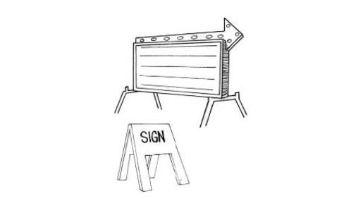
Sign, freestanding. Any sign supported wholly or in part by some structure other than the building or buildings housing the use to which the sign pertains.
Sign, home occupation. A sign that advertises or identifies a properly permitted home occupation.
Sign, identification. A sign giving the name or other attributes of a business or entity, for the purposes of identification.
Sign, incidental. A sign providing information or direction regarding the use upon which the sign is located. Incidental signs include help wanted signs, open/closed signs, signs indicating hours of operation, signs directing traffic flow through the site, menu boards, signs identifying drive-thru lanes, and similar signs.

Signs, indirectly illuminated. Any sign that is completely or partially illuminated at any time by an external light source that is so shielded as to not be visible at eye level.
Signs, inflatable. A sign that is intended to be expanded by air or other gas for its proper display or support.
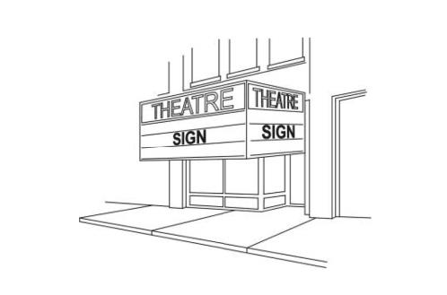
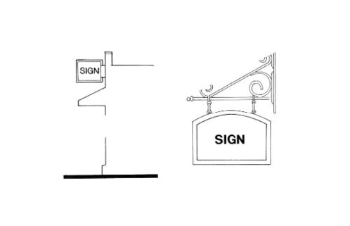
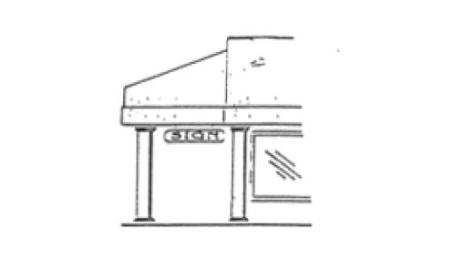
Sign, marquee. Any sign attached flat against the marquee or permanent sidewalk canopy of a building and not extending above the roofline.
Sign, monument. An identification sign that rises from the ground and has no clearance under it, with an opaque base having a width at least 80 percent of the width of the sign at the widest point.

Sign, off-premises. A sign, including billboards and poster panels, that directs attention to a business, commodity, service, activity or product sold, conducted or offered of the premises where such sign is located.
Sign, on-premises. A sign, that directs attention to a business, commodity, service, activity or product sold, conducted or offered on the premises where such sign is located.
Sign, open house. A sign advertising real property for sale is open for view by the public.
Sign, peddler's. A sign utilized by a person with a peddler's license issued by the City of Belton.
Sign, permanent. A sign that is permanently affixed to a building surface, parapet or overhang or is a monument type sign designed to remain in the original location.
Sign, pole. Any detached sign with an opaque base, pole, or pedestal that is not at least 80 percent of the width of the sign at its widest point.
Sign, political. Any sign advertising a political candidate, political party or ballot issue.
Sign, portable. A sign that is not permanently affixed to one location and has the capability of being moved from one site to another.
Sign, projecting. Any sign extending more than one foot from the face of the building to which it is attached.
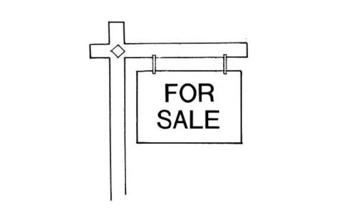
Sign, real estate. A sign advertising a piece of real property for sale or lease located on the real property that is for sale.
Sign, real estate directional. A sign directing attention to a piece of real property for sale or lease that is located on the real property that is for sale.
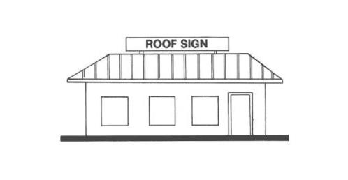
Sign, roof. A sign that extends above a roof or parapet wall of a building and that is wholly or partially supported by said roof.
Sign, semi-illuminated. Any sign that is uniformly illuminated over its entire area, including the area of the sign, by use of electricity or other artificial light.
Sign, snipe. Any sign of a material such as cardboard, paper, pressed wood, plastic or metal that is attached to a fence, tree, light pole, utility pole or temporary structure or those staked into the ground, or any sign that is not securely fastened to a building or firmly anchored to the ground.
Sign, subdivision amenity. A sign directing traffic to amenities such as a clubhouse or swimming pool within the subdivision.
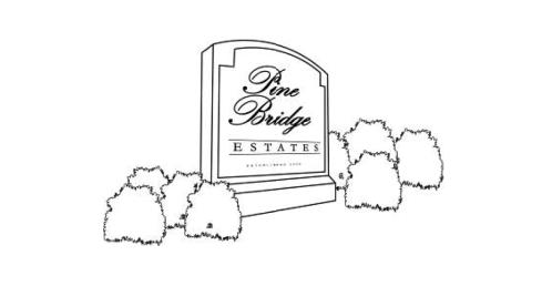
Sign, subdivision entrance. A detached sign indentifying the subdivision, located at one or more of the subdivision entrances.
Sign, temporary. A sign not intended, designed or installed for permanent display.
Sign, under canopy. A display attached to the underside of a marquee or canopy and protruding over public or private sidewalks or right-of-way.
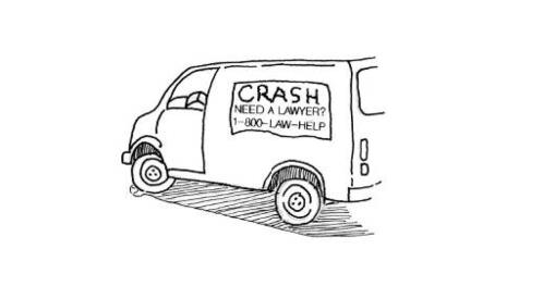
Sign, vehicle. A sign attached to, placed upon, mounted, painted, pasted, or drawn on any vehicle or trailer that is parked on a property for the principal purpose of displaying the sign message and is not regularly and customarily used in the operation of the business.
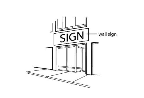
Sign, wall. A sign attached to or erected against an exterior wall of a building or structure that projects not more than 12 inches from a wall and presents only one face with advertising copy to the public and does not extend above the roof line.
Site plan. An accurately scaled development plan that illustrates the existing conditions on a parcel as well as depicting details of a proposed development, including topographic characteristics; the location and dimensions of buildings, yards, courts, landscape, pedestrian and vehicular circulation and parking, fences and screening.
Special flood hazard area. See "area of special flood hazard."
Special hazard area. An area having special flood hazards and shown on an FHBM, FIRM, or FBFM as zones (unnumbered or numbered) A and AE. Specified anatomical area. Uncovered or exposed human genitals, pubic region or pubic hair, buttocks, female breasts below a point immediately above the top of the areola encircling the nipple, or any combination of the foregoing; or human male genitals in a discernible erect state, even if completely and opaquely covered.
Specified sexual activities. Means any of the following acts of intended sexual arousal or excitement:
(1)
Sexual conduct including, but not limited to, actual or simulated acts of sexual intercourse, masturbation, oral copulation or sodomy;
(2)
Fondling or other intentional touching of a person's clothed or unclothed genitals, pubic area, buttocks, or the breast of a female;
(3)
Sadomasochistic acts; or
(4)
Acts involving animals or latent objects.
Start of construction. Includes substantial improvements, and means the date the building permit was issued, provided the actual start of construction, repair, reconstruction, rehabilitation, addition placement or other improvements were within 180 days of the permit date. The "actual start" means either the first placement of permanent construction of a structure on a site, such as the pouring of slabs or footings, the installation of piles, the construction of columns, and work beyond the stage of excavation; or the placement of a manufactured home on a foundation. Permanent construction does not include land preparation, such as clearing, grading and filling, the installation of streets and/or sidewalks, excavation for a basement, footings, piers, foundations, the erection of temporary forms, nor installation on the property of accessory buildings, such as garages or sheds not occupied as dwelling units or not part of the main structure. For a substantial improvement, the "actual start of construction" means the first alteration of any wall, ceiling, floor or other structural part of the building, whether or not that alteration affects the external dimensions of the building.
State coordinating agency. That agency of the state government or other office designated by the governor of the state or by state statute at the request of the Federal Flood Insurance Administrator to assist in the implementation of the National Flood Insurance Program (NFIP) in that state.
Story. That portion of a building included between the upper surface of a floor and the upper surface of the floor or roof next above.
Stream. Any watercourse identified on the City of Belton Stream Map.
Stream centerline. The sloping land that contains the stream channel and the normal flows of the stream.
Stream channel. The portion of a watercourse that contains the base flow of the stream.
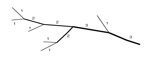
Stream order. The Strahler classification system for streams based on stream hierarchy and the position within a watershed. The smaller the stream, the lower its numerical classification. Stream order is determined by a combination of factors, including the confluence of smaller streams, increased flow from contributing water sources and the size of the watershed that feeds the stream. First order streams are the smallest streams regulated by this section; the term does not include roadside ditches. When two first-order streams come together, they form a second-order stream. When two second-order streams come together, they form a third-order stream. Streams of lower order joining a higher order stream do not change the order of the higher stream. Thus, if a first-order stream joins a second-order stream, it remains a second-order stream. It is not until a second-order stream combines with another second-order stream that it becomes a third-order stream. Streams orders are designated on the City of Belton Stream Map. An example of stream orders is shown below.
Street. A right-of-way dedicated to the public use which provides vehicular and pedestrian access to adjacent properties.
Street hierarchy. The conceptual arrangement of streets based upon the function. A hierarchical approach to street design classifies streets according to function, from high-traffic arterial roads down to streets whose function is residential access. Systematizing street design into a road hierarchy promotes safety, efficient land use, and residential quality.
Street, intersecting. Any street, which joins another street, whether or not it crosses the other.
Street line. A dividing line between a lot, tract, or parcel of land and the contiguous street.
Street network. The following street designations are adopted as a part of the transportation component of the comprehensive plan.
(1)
Local streets: provides access to properties.
(2)
Collector streets: conducts traffic from local streets to arterial streets, with access to properties.
(3)
Arterial streets: carries traffic out of and through the area, subject to certain control of entrances, exits and curb cuts.
Structure.
(1)
Anything constructed or erected with a fixed location on the ground, or attached to something having a fixed location on the ground. Among other things, "structures" include buildings, walls, fences, signs, billboards, sheds, towers, and bins. For purposes of this section, central air-conditioning condensing units and similar cooling system apparatus, other than so-called "window" or "room" conditioners, will be considered as structures.
(2)
For floodplain management purposes, a walled and roofed building, including a gas or liquid storage tank, that is principally above ground, as well as a manufactured home. For insurance purposes, "structure" means a walled and roofed building, other than a gas or liquid storage tank, that is principally above ground and affixed to a permanent site, as well as a manufactured home on a permanent foundation. For the latter purpose, the term includes a building while in the course of construction, alteration or repair, but does not include building materials or supplies intended for use in such construction, alteration or repair, unless such materials or supplies are within an enclosed building on the premises.
Stub street. A portion of a street for which an extension has been proposed and approved. May be permitted when development is phased over a period of time, but only if the street in its entirety has been approved in the preliminary plat.
Subdivider. A person, firm, corporation, partnership, or association which causes land to be divided into a subdivision for itself or for others.
Subdivision. The division of a tract of land into two or more lots or parcels for the purpose of transfer of ownership or building development, or, if a new street is involved, any division of a parcel of land. The term "subdivision" includes "re-subdivision," and the term "re-subdivision," as used herein, will include any further subdivision of a lot or parcel of land previously subdivided for sale, use, or other purposes, which vary from the latest, approved plat of the same.
Substantial damage. Damage of any origin sustained by a structure whereby the cost of restoring the structure to pre-damaged condition would equal or exceed 50 percent of the market value of the structure before the damage occurred.
Substantial improvement. Any reconstruction, rehabilitation, addition or other improvement of a structure, the cost of which equals or exceeds 50 percent of the market value of the structure before start of construction of the improvement. The term includes structures which have incurred substantial damage, regardless of the actual repair work performed. The term does not, however, include either:
(1)
Any project for improvement of a structure to correct existing violations of state or local health, sanitary or safety code specifications that have been identified by the local code enforcement official and which are the minimum necessary to assure safe living conditions, or
(2)
Any alteration of a "historic structure," provided that the alteration will not preclude the structure's continued designation as a "historic structure."
Surveyor. A professional land surveyor registered in the State of Missouri.
Trailer, hauling. A vehicle to be pulled behind an automobile or truck which is designed for hauling animals, produce, goods or commodities, including boats.
Trailer, travel or camper. A portable or mobile living unit used for temporary human occupancy away from the place of residence of the occupants, and not constituting the principal place or residence of the occupants.
Transient guest. Any person who rents and occupies a guest room in a lodging establishment for a period of less than 31 days.
Trash receptacle. A container used for the temporary storage of rubbish or materials pending collection.
Unified Development Code. The terms "Unified Development Code," "these regulations," or "this Code" mean the requirements contained in the Unified Development Code of the City of Belton.
Unit of development. A lot, parcel, building site, or building proposed in a development or subdivision.
Use. Any purpose for which a structure or a tract of land may be designed, arranged, intended, maintained, or occupied; also, any activity, occupation, business, or operation carried on, or intended to be carried on, in a structure or on a tract of land.
USGS. United States Coast and Geodetic Survey.
Variance.
(1)
A waiver from compliance with a specific provision granted to a particular property owner because of the practical difficulties or unnecessary hardship that would be imposed by the strict application of that provision of this section.
(2)
A grant of relief by the community from the terms of a floodplain management regulations. Flood insurance requirements remain in place for any varied use or structure and cannot be varied by the community.
Violation. The failure of a structure or other development to be fully compliant with the community's floodplain management regulations. A structure or other development without the elevation certificate, other certification or other evidence of compliance required by this section is presumed to be in violation until such time as that documentation is provided.
Visitor. An individual visiting a person or place temporarily, especially socially.
Water ponding area. Limits of the area inundated as a result of run-off from the 100-year storm.
Water surface elevation. The height, in relation to the National Geodetic Vertical Datum (NGVD) of 1929 (or other datum where specified) of floods of various magnitudes and frequencies in the floodplain.
Watercourse. The natural stream channel. A running stream of water; a natural stream fed from permanent or natural sources, including rivers, creeks, and streams. It must flow in a definite channel, having a bed or banks. It must be something more than mere surface drainage over the land.
Watershed. The land area that drains into a particular stream.
Wireless communication facility. A facility related to the use of the radio frequency spectrum for the purposes of transmitting or receiving radio signals, and may include, but is not limited to radio towers, television towers, telephone exchanges, micro-wave relay towers, telephone transmission equipment buildings and commercial mobile radio service facilities. The wireless communication facility use category includes all associated equipment unless the written context clearly indicates that another meaning is intended. The term "associated equipment" is to be read broadly and in context. Associated equipment may include, but is not limited to: antenna, equipment shelter or platform, lighting, monopole tower, mounting hardware, and supporting electrical or mechanical equipment.
Yard. A space on the same lot with a main structure, open, unoccupied and unobstructed by structures from the ground upward.
Yard, front. A yard located in the front of a lot between the front property line and the main building or any projection thereof, excluding steps and un-enclosed porches having a height of no greater than three feet, and also extending from side lot line to side lot line.
Yard, rear. A yard extending across the rear of a lot measured between lot lines and being the minimum horizontal distance between the rear lot line and the rear of the main building or any projections other than steps, un-enclosed balconies or un-enclosed porches. On corner lots, the rear yard shall be considered as parallel to the street upon which the lot has its least dimension. The rear yard shall in all cases be at the opposite end of the lot from the front yard.
Zoning administrator. The person or persons authorized and empowered by the city manager to administer the requirements of these zoning regulations.
Zone, district or zoning district. A portion of the city the boundaries of which are designated on the official zoning map and for which the regulations governing the use, height, area, size, and intensity of use of buildings and land are uniform.
(UDC 2010, § 2.1; Ord. No. 2005-3171, 9-6-2005; Ord. No. 2007-3317, 2-27-2007; Ord. No. 2008-3475, 8-12-2008; Ord. No. 2011-3736, § 1, 7-26-2011; Ord. No. 2012-3880, § 1, 12-18-2012; Ord. No. 2013-3937, § 1, 7-23-2013; Ord. No. 2015-4073, § 1, 3-10-2015; Ord. No. 2018-4414, § 1, 3-13-2018; Ord. No. 2018-4477, § 1, 11-27-2018; Ord. No. 2019-4529, § 1, 7-9-2019; Ord. No. 2021-4604, § 1, 1-12-2021; Ord. No. 2023-4751, § 1, 1-10-2023; Ord. No. 2023-4750, § 1, 1-10-2023; Ord. No. 2023-4777, § 1, 6-13-2023; Ord. No. 2024-4836, § 1, 2-27-2024; Ord. No. 2025-4912, § 2 (Exh. B), 4-29-2025)
State Law reference— Similar definitions, RSMo 315.005.
Sec. 1-6. - Zoning map.
The boundaries and location of the zoning districts as defined by this Code as identified on the official zoning map, entitled "Zoning Map of the City of Belton, Missouri." The official zoning map, together with all notations, references and information shown on the map is hereby incorporated by reference and made part of this Code. The map must remain on file and available to the public in the office of the community development director.
(UDC 2010, § 1.5)
Sec. 1-7. - Interpretation of zoning district boundaries.
Where uncertainty exists with respect to the zoning district boundaries, the zoning district boundaries will be construed as follows:
(1)
Corporate limits;
(2)
United States public land survey lines;
(3)
Property lines;
(4)
Centerlines of streets, alleys, waterways, easements and railroad rights-of-way lines or extensions of such lines; or
(5)
Where they do not coincide with the above, the district boundaries will be determined by the use of the scale shown on the official zoning map.
(UDC 2010, § 1.6)
Sec. 1-8. - Annexed land.
(a)
Voluntary annexations. Applications for any and all land to be voluntarily annexed into the city shall have a statutorily affirmed right to use either an extended option or an abbreviated option. Planning staff shall provide all applicants for annexation with information related to both extended and abbreviated procedures but make no recommendations.
(1)
The extended option shall follow all the provisions and procedures as established under the provisions of RSMo. 71.012, as amended.
(2)
The abbreviated option shall follow all the provisions and procedures as established under the provisions of RSMo. 71.014, as amended.
(b)
Involuntary annexations. To involuntarily annex property into the corporate limits of the City of Belton, the provisions and procedures established by RSMo. 71.015, as amended, shall be complied with in full. The City of Belton shall proceed under an involuntary annexation procedure when:
(1)
A written objection has been filed as outlined in RSMo. 71.012;
(2)
When not all of the owners of a tract to be annexed have consented to, and signed the verified petition as provided in RSMo. 71.012;
(3)
When the city desires to annex property without the consent of the owners as outlined in RSMo. 71.015.
(c)
Zoning of annexed property. All real property that is voluntarily or involuntarily annexed into the corporate limits of the City of Belton pursuant to the provisions of this chapter shall retain the zoning designation originally established by the county. The zoning designation shall be retained until the annexed real property is appropriately rezoned in accordance with the requirements and procedures established by the City of Belton as provided for in RSMo. ch. 89, as amended. These requirements shall include, but not [be] limited to, the notice and public hearing requirements incorporated by this Code and the Zoning Enabling Act, as provided for in RSMo. ch. 89, as amended.
(UDC 2010, § 1.7)
Sec. 1-9. - Word usage and construction of language.
(a)
Meaning and intent. All provisions, terms, phrases and expressions used in this Code will be construed according to the purpose and intent set out in the Code.
(b)
Headings, illustrations and text. In case of any difference of meaning or implication between the text of this Code and any heading, drawing, table, figure or illustration, the text controls.
(c)
Lists and examples. Unless otherwise specifically indicated, lists of items or examples that use terms such as "including," "such as," or similar language are intended to provide examples; not to be exhaustive lists of all possibilities.
(d)
Computation of time. The time in which an act is to be done will be computed by excluding the first day and including the last day. If the last day is a Sunday or legal holiday observed by the city, that day will be excluded. When the period of time prescribed or allowed is less than seven days, intermediate Sundays and legal holidays observed by the city will be excluded in the computation. Any half-holidays will not be counted as a legal holiday for purposes of this Code.
(e)
References to other regulations, publications and documents. Whenever reference is made to a resolution, ordinance, statute, regulation or document, that reference will be construed as referring to the most recent edition of such resolution, ordinance, statute, regulation, or document or to the relevant successor document, unless otherwise expressly stated.
(f)
Delegation of authority. Whenever a provision appears requiring the head of a department or another officer or employee of the city to perform an act or duty, that provision will be construed as authorizing the department director or officer to delegate that responsibility to others over whom they have authority.
(g)
Technical and non-technical terms. Words and phrases will be construed according to the common and approved usage of the language, but technical words and phrases that may have acquired a peculiar and appropriate meaning in law will be construed and understood according to such meaning.
(h)
Public officials and agencies. All public officials, bodies and agencies to which references are made are those of the City of Belton, unless otherwise expressly provided.
(i)
Mandatory and discretionary terms. The words "shall" and "will" and "must" are mandatory. The words "may" and "should" are discretionary and advisory terms.
(j)
Conjunctions. Unless the context clearly suggests the contrary, conjunctions will be interpreted as follows:
(1)
"And" indicates that all connected items, conditions, provisions or events apply; and
(2)
"Or" indicates that one or more of the connected items, conditions, provisions or events may apply.
(k)
Tenses and plurals. Words used in one tense (past, present or future) include all other tenses, unless the context clearly indicates the contrary. The singular includes the plural and the plural includes the singular.
(l)
Other rules. In the construction of the Unified Development Code, the provisions and rules of this section must be preserved and applied, except when the context clearly requires otherwise:
(1)
The phrase "used for" will include the phrases "arranged for," "designed for," "intended for," "maintained for" and "occupied for";
(2)
The word "person" includes individual, firms, corporations, associations, governmental bodies, and agencies, and all other legal entities;
(3)
The abbreviation "N/A" means not applicable;
(4)
The word "city" means City of Belton, Missouri;
(5)
The word "council" means the Belton City Council;
(6)
The word "director" means the community development director;
(7)
The word "commission" means the city planning commission;
(8)
The word "board" means the board of zoning adjustment;
(9)
Unless otherwise specified, all distances will be measured horizontally; and
(10)
The term "comprehensive plan," "growth management plan" and "city plan" mean the Growth Management Plan adopted by the planning commission in accordance with RSMo. 89.300 et seq., and as from time to time amended.
(UDC 2010, § 1.8)
Sec. 1-10. - Interpretation.
(a)
Minimum requirements. In their interpretation and application, the provisions of this Code will be held to be the minimum requirements for the promotion of the public health, safety, morals and welfare.
(b)
Conflicting or overlapping regulations.
(1)
Conflict or overlap with state and federal regulations. If the provisions of this Code are either more restrictive or less restrictive than comparable conditions imposed by the state or federal government, the regulations which are more restrictive will govern, to the extent permitted by law.
(2)
Conflict or overlap with other city regulations. If the provisions of this Code are inconsistent with one another, or if they conflict with provisions found in other adopted city ordinances the more restrictive provision will control. No text amendment, variance or special use permit or any other development approval under this Code may diminish the provisions of any other more restrictive city ordinance.
(3)
Conflict or overlap with private agreements. This Code is not intended to abrogate, annul or otherwise interfere with any private easement, covenant, restriction, agreement or legal relationship; provided however, that where the provisions of this Code are more restrictive (or impose higher standards of requirements) than such easement, covenants or other private agreements or legal relationship, the provisions of this Code will govern. The city does not enforce private agreements, easements, covenants or restrictions except those specifically required for the administration and enforcement of this Code, even where the private agreements are more restrictive than the provisions of this Code.
(4)
Development agreements and memorandums of understanding. Terms and conditions agreed to as part of an approved development agreement or memorandum of understanding are in addition to the requirements of this Code.
(UDC 2010, § 1.9)
Sec. 1-11. - Exemption.
The following structures and uses are exempt from the provisions of this Code:
(1)
Poles, wires, cables, conduits, laterals, pipes, mains, valves or other similar equipment for the distribution to consumers of telephone or other communications, electricity, gas or water, or the collection of sewage or surface water operated or maintained by a public utility but not including substations or accessory utility facilities located on or above the surface of the ground.
(2)
Railroad tracks, signals, bridges, and similar facilities and equipment located on a railroad right-of-way, and maintenance and repair work on such facilities and equipment.
(3)
Signs exempted from regulation.
(UDC 2010, § 1.10)
Sec. 1-12. - Transitional provisions for violations.
Any violation of the previous zoning or subdivision regulations of the city will continue to be a violation under this Code and will be subject to penalties and enforcement unless the use, development, construction or other activity is consistent with the express terms of this Code, in which case enforcement action will cease, except to the extent of collecting penalties for violations that occurred before the effective date specified.
(UDC 2010, § 1.11)
Sec. 1-13. - Completion of development.
(a)
Permits issued before effective date. Any building, development or sign for which a permit was lawfully issued before the effective date specified may be completed in conformance with the issued permit. If the building, development or sign is not completed within the time allowed under the original permit, then the building, development or sign shall be constructed, completed or occupied only in strict compliance with this Code.
(b)
Preliminary plats approved before effective date. If a preliminary plat was approved before the effective date specified, final plat approval may be granted in accordance with the preliminary plat. Final plats shall comply with all requirements of this Code.
(c)
Preliminary development plans approved before effective date. If a preliminary development plan for a planned unit development was approved before the effective date, final plat approval may be granted in accordance with the preliminary plan. Final plats shall comply with all requirements of this Code.
(UDC 2010, § 1.12)
Sec. 1-14. - Special uses.
(a)
Any use that was legally established before the effective date specified without a special use permit and which after the effective date is located within a zoning district that requires a special use permit for the subject use under this Code, will be issued a special use permit without following the procedures. The use and any proposed expansions or modifications will be subject to all applicable standards of this Code, including any new or modified use standards and the regulations for nonconformities.
(b)
Any use that was legally established before the effective date specified by a special use permit and which after the effective date is located within a zoning district that requires a special use permit for the subject use, may continue to be operated under the terms of the original special use permit. The use and any proposed expansions or modifications will be subject to all applicable standards of this Code, including any new or modified use standards and the regulations for nonconformities.
(c)
Any use that was legally established before the effective date specified with a special use permit and which after the effective date is located within a zoning district that does not require a special use permit for the subject use, will continue to be subject to all applicable standards of this Code, including any new or modified use standards and the regulations for nonconformities. Conditions established as part of the original approval of the special use permit shall remain in effect and be continuously followed.
(UDC 2010, § 1.13)
Sec. 1-15. - Severability.
It is hereby declared to be the intention of the city that the provisions of this Code are separable, in accordance with the following rules:
(1)
If any court or competent jurisdiction will adjudge any provision of this Code to be invalid, such judgment will not affect any other provisions of this Code.
(2)
If any court or competent jurisdiction will adjudge invalid the application of any provision of this Code to a particular property or structure, such judgment will not affect the application of said provisions to any other property or structure.
(UDC 2010, § 1.14)
Sec. 1-16. - Fire and public safety.
(a)
In areas where natural gas is available, the storage or use of LP gas in excess of 100 pounds shall be prohibited unless specifically approved by the development review committee and indicated on the approved development plan.
(b)
No traffic calming devices (i.e., speed bumps, etc.) may be installed prior to plans being reviewed and approved by the development review committee. Any traffic calming devices that cause undue jarring, create a safety hazard, or obstruct fire department access are prohibited.
(UDC 2010, § 1.29)