
Largo City Zoning Code
CHAPTER 8
GENERAL DEVELOPMENT STANDARDS AND IMPACT FEES
Section 8.7 - Parkland and Recreation Facilities Impact Fees[1]
Editor's note—Ord. No. 2025-01, § 23, adopted Dec. 17, 2024, renumbered Section 8.6, §§ 8.6.1—8.6.6 as Section 8.7, §§ 8.7.1—8.7.6.
Section 8.8 - Open Space Standards[2]
Editor's note—Ord. No. 2025-01, § 24, adopted Dec. 17, 2024, renumbered Section 8.7, §§ 8.7.1, 8.7.2 as Section 8.8, §§ 8.8.1, 8.8.2.
8.1.1 - Purpose
To protect the general health, safety, and welfare of the citizens of Largo and to implement the adopted Largo Comprehensive Plan through the application of detailed land development standards. The specific standards herein regulate the density and intensity of development, building setbacks, placement and height, impervious surface ratio (ISR), and the transfer of development rights.
8.1.2 - Authority
All proposed developments must comply with the development standards established in this CDC and all the provisions of the adopted Comprehensive Plan. Compliance is a precondition for the issuance of a Development Order (DO) and/or Development Permit (DP).
8.1.3 - Applicability
The development of any use shall be permitted only in full compliance with the performance standards described in this CDC.
8.2.1 - Objective
To provide for the proper location of uses consistent with their traffic generation and density/intensity characteristics.
8.2.2 - Gross Site Area and Net Land Area
Gross site area shall be calculated based on the total area of the parcel or the total area of contiguous parcels, under common ownership, that will be or have been platted as one (1) parcel prior to the issuance of a Certificate of Occupancy for the given project. Land needed for drainage improvements, including retention/detention areas, existing ponds, lakes and streams, wetlands, private streets, future public rights-of-way, parkland dedication, circulation, recreation facilities, etc., shall be included in the calculation. However, land in existing public rights-of-way and any parcels with no allowable density shall not be included in density calculations.
Net land area for the purposes of computing density/intensity shall be that total land area within the property boundaries of the subject parcel, specifically exclusive of any submerged land or public road right-of-way.
(Ord. No. 2025-08, § 26, 6-17-2025)
8.2.3 - Density
A.
Residential density is measured by units per acre (U/A) of net land area. Units per acre regulates the density of residential development based on the policies of the Comprehensive Plan. The maximum number of dwelling units (DU) that can be developed on a parcel may not exceed the density limits of the Future Land Use Map (FLUM) classification, with the exception of existing single-family lots in accordance with Section 8.3.2. Applicants may also consider a Transfer of Development Rights, pursuant to the requirements of Section 4.7, or Density/Intensity Averaging, pursuant to the requirements of Section 8.2.5.
(1)
Units per Acre (U/A) = Total number of Units per each acre.
(2)
Calculation:
a.
Existing/Proposed Units per Acre is calculated by dividing the total number of units by the number of acres represented by the net land area (see Section 8.2.2).
b.
Maximum Units per Acre is calculated by multiplying the density allowed for the FLUM classification for a parcel by the number of acres represented by the net land area rounded down to the next whole dwelling unit.
B.
An allowable accessory dwelling unit will not count as a dwelling unit when calculating the maximum residential density of the FLUM classification.
(Ord. No. 2025-01, § 15, 12-17-2024; Ord. No. 2025-08, § 27, 6-17-2025)
8.2.4 - Intensity
A.
Intensity is measured by Floor Area Ratio (FAR) and is applicable only to non-residential uses.
(1)
Calculation:
a.
Floor Area Ratio (FAR): The gross floor area square footage of non-residential buildings divided by the square footage of the net land area.
b.
Gross Floor Area: The sum of the horizontal areas of all floors within building walls covered by a roof, measured to the outside surfaces of exterior walls including the floor area of all ancillary non-residential uses.
(2)
Table 8-1 provides a maximum permitted ratio of total square footage of the gross floor area of all buildings on a lot to the net land area of a lot for non-residential uses.
(3)
Mixed-use developments can use a proportional split of the maximum Floor Area Ratio (FAR) and Dwelling Units per Acre (DU/A) allowed by the underlying land use classification.
Example: A 2-acre site with a R/OG land use classification can be developed up to either 43,560 sq. ft. (0.50 FAR) or 30 dwelling units (15 DU per acre), or a combination of both. The development could include, for example, 8,712 sq. ft. of office space and 24 residential units, or 17,424 sq. ft. of office space and 18 residential units. However, the total development must not exceed the maximum limits for both floor area and density.
(Ord. No. 2025-01, § 16, 12-17-2024; Ord. No. 2025-08, § 28, 6-17-2025)
8.2.5 - Density and Intensity for Mixed Use Projects and developments in Multimodal Corridor and Activity Centers
A.
Density and intensity of mixed use developments and developments within designated
Multimodal Corridors and Activity Centers shall not exceed, in total, the maximum
number of permitted units and the maximum FAR for the underlying land use, except
where permitted under Countywide Rules. The following example shows how density and
intensity may be stacked on a single site:
Example: A mixed use development is proposed for a two (2) acre site (87,120 sq. ft.)
within a designated Multimodal Activity Center. The site has a land use designation
of R/OR. The site can develop to a maximum of 43,560 sq. ft. (.50 FAR) in addition
to thirty dwelling units (15 DU per acre). The proposed mixed use development would
include 43,560 sq. ft. of professional office space (.50 FAR) and thirty (30) dwelling
units (15 DU per acre).
B.
In accordance with Countywide Rules, Density/intensity averaging is the aggregation of the otherwise permitted density and/or intensity of a parcel or parcels of land in a non-uniform or consolidated manner on a portion of such contiguous parcels. Lots are contiguous when parcels touch along a boundary or directly across any roadway or other right-of-way from each other. Density/intensity averaging is permitted in accordance with the Countywide Rules within a single Activity Center or Multimodal Corridor as a whole, provided that:
(1)
The maximum density or intensity standard for the applicable subcategory is not exceeded on an average areawide basis; and
(2)
Adoption and subsequent amendment of density/intensity standards is subject to the provisions of the Countywide Rules.
C.
Density/intensity averaging, within the Multimodal Corridors and Activity Centers as otherwise governed by the Countywide Rules shall be allowed to include any development rights available to, but previously unused by, existing developed property that is being added to or redeveloped using the density/intensity averaging provision.
D.
The City shall maintain permanent records of all deed restrictions and covenants recorded, and development rights averaged between two contiguous parcels, and make available forms on which to apply for density/intensity averaging. The density/intensity averaging application shall be part of an application for a development permit and any associated development agreement, if required, to develop the property. The Development Controls Officer shall be responsible for the following:
(1)
The density/intensity averaging application shall contain:
a.
A signed written agreement between the two parcel owners.
b.
A certificate of title for each parcel prepared by an attorney licensed to practice law in the State of Florida.
c.
Two copies of signed and sealed surveys, including legal descriptions, for the proposed parcels prepared by licensed land surveyor.
d.
A statement of the type and number of development rights in terms of density or intensity being averaged.
e.
Such additional information required the by the Development Controls Officer as necessary to determine the number of development rights that qualify for averaging.
(2)
A density/intensity averaging certificate shall identify:
a.
The two parcel owners
b.
A legal description of the two parcels to be averaged on which the calculation of the development rights is based.
c.
A statement of the number of development rights in either dwelling units per net acre or square feet of nonresidential floor area eligible for averaging.
d.
If only a portion of the total density/intensity available for averaging is used, a statement of the number of remaining development rights in either dwelling units per net acre or square feet of nonresidential floor area remaining on the properties.
e.
The date of issuance.
f.
The signature of the Development Controls Officer.
g.
A certificate number and/or case number assigned by the Development Controls Officer.
(3)
The recording mechanism shall be consistent with the Countywide Rules, and shall at a minimum, require written evidence of the density/intensity averaging in a document to be recorded in the official records with the Clerk of the Circuit Court for Pinellas County, and a record copy of the same to be filed with Forward Pinellas. The instrument of transfer shall conform to the requirements of this section and contain the following information:
a.
The names of the parcel owners.
b.
A certificate of title for the rights to be averaged prepared by an attorney licensed to practice law in the State of Florida.
c.
A legal description and survey of the parcels being averaged by a licensed surveyor named in the instrument, certified to the City of Largo.
d.
The density/intensity averaging certificate described in Section 8.2.5(D)(2) above.
e.
A covenant between the parties that assigns a specific number of development rights to be averaged and stating that it shall run with the land and be binding on the owners' heirs, assigns, and successors. .
f.
A covenant by which the transferor acknowledges that they have no further use or right of use with respect to the development rights being averaged, which shall state that the covenant runs with the land and is binding on the owners' heirs, assigs and successors.
g.
A covenant indicating the number of development rights remaining on the parcels stating that the parcels may not be subdivided or developed to a greater density or intensity than permitted by the remaining development rights which shall state that the covenant runs with the land and is binding on the owners' heirs, assigs and successors.
h.
A covenant that all provisions of the instrument of averaging shall run with and bind the parcels, will run with the land and may be enforced by the City of Largo.
i.
Any other relevant information or covenants.
Example: A new mixed use development is proposed for Property A, a one (1) acre site within a designated Activity Center. Property A has been approved for a development order for construction of a two-story, 78,408 sq. ft. building with retail on the ground floor, with office above. The property's base allowable dwelling units is 30. However, the development will not be building residential units nor will the property owner be using the density. Property B is contiguous to Property A, and the owner of Property B is proceeding through the site plan review process to develop an apartment complex with ground floor retail on Property B. Located within the Activity Center, Property B is two (2) acres and the owner will be constructing a mixed-use apartment complex using optional design guidelines to develop 90 dwelling units. However, the owner would like to develop 100 dwelling units total as part of the redevelopment. The owner of Property A agrees to transfer ten (10) dwelling units to the owner of Property B to complete the desired project on Property B. The two parties enter into an agreement through the density/intensity averaging certificate process, and as a condition of the Development Order by the City for each project, the transfer of density is recorded against the properties as a covenant running with the land.
(Ord. No. 2021-40, § 2, 6-1-2021; Ord. No. 2025-08, § 29, 6-17-2025)
8.2.6 - Residential Equivalents
A.
Clustering - Single-family developments with individually platted lots may be clustered and have less than five thousand (5,000) square feet per lot, provided the total development contains sufficient land in common ownership to make up the per-lot differential.
B.
Zero lot line - Zero Lot Line Developments are allowed in all land use designations with shared wall agreements.
C.
Assisted Living Facilities (ALFs) - ALFs and similar uses shall be calculated as two and one-half (2.5) beds equals one (1) dwelling unit.
(Ord. No. 2025-01, § 17, 12-17-2024)
8.2.7 - Impervious Surface Ratio (ISR)
Impervious surface is a measure of use intensity. The control of impervious surfaces ensures continued absorption of rainwater, aids in the control of stormwater runoff, and implements the policies of the Natural Resources Element of the Comprehensive Plan.
A.
Method of calculation - The maximum allowable impervious surface coverage, or that portion of the site which may be covered by building, paving, or other impervious materials, is expressed as a ratio. The ratio is calculated by dividing the total impervious surface area by the gross area of the site.
ISR = Total impervious area/Gross site area
B.
Use of pervious materials - The impervious square footage of areas covered by semipermeable materials, such as turf block or porous concrete, shall be calculated by multiplying the total square footage of these areas by the percentage of perviousness of the covering material. The use of semipermeable materials may be used, for purposes of ISR calculation only, to a maximum of fifty (50) percent of the required standard. These areas shall be considered pervious for purposes of drainage calculations.
C.
Residential properties - Maximum allowable Impervious Surface Ratio (ISR) for residential developments shall be determined for the entire project during site plan review. Swimming pools shall be considered impervious surfaces. The placement, installation, or construction of sealed material (which includes, but is not limited to asphalt, concrete, bricks, pavers, etc.) within front, side, or rear yards (including landscaped areas) of residential properties shall not result in an ISR of greater than sixty-five (65) percent of the entire parcel. A Development Permit shall be required for the placement, installation, or construction of sealed materials (which includes, but is not limited to asphalt, concrete, bricks, pavers, etc.) in residential yards.
8.2.8 - Exceptions
At the discretion of the DCO, developments may be prohibited from developing to the maximum ISR and/or intensity depending on underlying site conditions such as:
A.
Ground water quality and recharge capabilities;
B.
Stormwater percolation capacity across the site;
C.
Quality of stormwater discharge to adjacent wetlands or estuarine environments;
D.
Relationship of the proposed use to surrounding existing uses;
E.
Availability of public facilities and services to accommodate the project; and
F.
Level of Service (LOS) on the transportation network serving the project.
*Maximum FAR applies to non-residential uses only; see Section 8.2.4.
(Ord. No. 2025-01, § 18, 12-17-2024)
8.3.1 - Vacant Lots in Single-Family Subdivisions
Vacant lots within single-family platted subdivisions shall develop in compliance with established development standards in effect at the time of original platting. It is the intent of this Section to provide for compatibility in the construction of new residential units in areas approved for development prior to enactment of this CDC. Single-family dwellings to be constructed on previously platted lots are exempt from the concurrency review requirements.
8.3.2 - Development Standards for Infill Lots
A.
Single-family - If an existing residential lot, as subdivided prior to 1983 or as originally platted, contains less than the minimum lot size required for a single-family dwelling under this CDC, then one (1) single-family dwelling shall nevertheless be allowable on that lot or parcel, subject to compliance with all other development standards (e.g., setbacks, intensity/density, and allowable use). Section 17.5.H may apply to single-ownership non-conforming lot combinations.
B.
Duplexes, triplexes, and quadplexes - If an existing residential lot was platted or subdivided and developed with a duplex, triplex, or quadplex prior to 1983, then the same dwelling type shall be allowable on that lot provided the development complies with Section 8.6.
C.
Lots subdivided prior to 1983 or as originally platted - Existing single-family lots subdivided prior to 1983 or as originally platted shall use infill standards as described in Table 8-2. In addition:
(1)
Minimum side yard setback from an abutting right-of-way shall be fifteen (15) feet or twice the side yard setback, whichever is greater; and
(2)
The rear setback is reduced for dwellings with alley access for garages. The minimum setback for these units is five (5) feet from the alley right-of-way.
(Ord. No. 2023-04, § 3, 2-7-2023; Ord. No. 2025-01, § 19, 12-17-2024)
8.3.3 - Construction Requirements
The above standards and the following requirements must be complied with prior to issuance of any Development Permit on an infill lot:
A.
Construction Standards of Chapter 18;
B.
Erosion control and tree protection standards as described in Chapter 10 of this Code;
C.
The final grade elevation:
(1)
Shall be eighteen (18) inches to twenty-four (24) inches above the road crown, however it shall not exceed the grade elevation of the adjacent lots; and
(2)
Shall direct drainage away from the infill structure(s) and as well as any existing adjacent structures.
8.4.1 - Objective
To minimize the potential negative impacts from a new development upon existing adjacent uses; as well as to protect the new development from future uses on adjacent parcels.
8.4.2 - Building Placement
A.
Setback from abutting properties - Setback distance shall be measured at the narrowest distance between the structure wall and the property line.
(1)
One and two-story structures - Buildings shall be set back at least five (5) feet away from property lines, except where specified as an exception in 8.4.2.C or abutting rights-of-way.
(2)
Three-story and higher structures - Buildings higher than two (2) stories shall have a minimum setback of at least five (5) feet for the first two stories and five (5) additional feet for each additional story, except where specified as an exception in 8.4.2.C or abutting rights-of-way.
B.
Setback from abutting rights-of-way - The minimum setback from an abutting right-of-way shall be measured from the center line of the abutting right-of-way, except where specified as an exception in 8.4.2.C. To determine the right-of-way setback, see Table 8-3 Setbacks from Centerline and Figure 8-1 Setback from Abutting Right-of Way Example. See Section 9.2.4 for further clarification.
Figure 8-1: Setback from Abutting Right-of-Way Example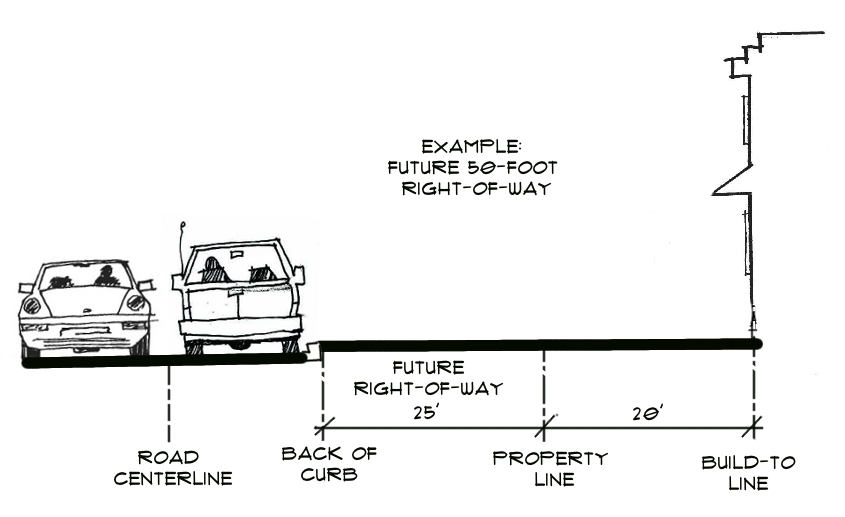
*Starkey Road is a minor arterial classification but has different setback requirements.
Source: Pinellas County Road Jurisdiction Viewer
C.
Exceptions
(1)
Development in Activity Centers and Multimodal Corridor overlays shall follow setback requirements contained in Chapter 7.
(2)
Clearwater-Largo Road Community Redevelopment District; setback standards shall follow specific CLR-CRD plan requirements.
(3)
West Bay Drive Community Redevelopment District (WBD-CRD); setback standards shall follow specific WBD-CRD Plan Requirements.
(4)
Minimum and maximum setbacks for small-type and medium-type housing are provided in Section 8.6, except that setbacks to a collector or arterial road shall be measured in accordance with Section 8.4.2.B.
(5)
Zero lot line development - A building may abut the property line only under the following conditions:
a.
Attachment easements or maintenance agreements between the subject property and the affected adjacent properties shall be provided and are subject to approval. The maintenance agreement must grant a minimum of a five (5) foot ingress and egress easement for the purpose of maintenance;
b.
To allow the use of zero lot line, the subject property and affected adjacent property must have the same land use designation.
c.
Plantings required as part of a landscaping buffer must still be provided on the site; and
d.
Roof overhangs (eaves), not including vertical supports, may extend into the setback area, but not beyond a property line.
Figure 8-2: Zero Lot Line Placement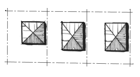
D.
Separation between structures - Minimum spacing between structures must meet the building separation standards in the Florida Building Code.
(Ord. No. 2025-01, § 20, 12-17-2024)
8.5.1 - Method of Calculation
When maximum building heights are specified in feet rather than stories, building height shall be calculated from the average elevation of the finished grade adjacent to the base of the building and running along its frontage to the highest point of the building's roof, excluding elevator shafts or stairwells that rise above roof level, and any architectural attachments and/or embellishments.
(Ord. No. 2025-01, § 21, 12-17-2024)
8.5.2 - Exceptions
[Reserved]
8.5.3 - Maximum Height
A.
Single-family Residential - The maximum residential building height for all residential lots, platted or unplatted, shall not exceed two (2) stories measured from the average elevation of the finished grade to the highest elevation of the structure, excluding the roof system, elevator shafts or stairwells that rise above roof level, and any architectural attachments and/or embellishments.
B.
Small-type and Medium-type Housing - Maximum building heights for small-type and medium-type housing are provided in Section 8.6.
C.
Multi-family and Non-residential - There is no height requirement for non-residential use types and multifamily developments. Instead, the bulk and height of a building is controlled by: required building setbacks and building separation; maximum impervious surface ratio; and site constraints such as required buffers and parking.
D.
Activity centers and Multimodal corridors - As required in individual Special Area Plans (see Chapter 7).
E.
The maximum residential building height for all lots located within a Special Flood Hazard Area (SFHA) which requires the first floor elevation to be one (1) foot above the base flood elevation shall not exceed two (2) stories measured from the lowest floor elevation to highest elevation of the structure, excluding the roof system, elevator shafts or stairwells that rise above roof level, and any architectural attachments and/or embellishments. The lowest residential floor elevation of one (1) foot above the base flood elevation is established in the Florida Building Code, Residential R322.2.1.
Figure 8-3: Maximum Single-Family Residential Building Height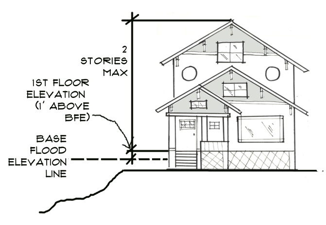
(Ord. No. 2019-43, § 1, 5-21-2019; Ord. No. 2025-01, § 21, 12-17-2024)
8.6.1 - Purpose
Small-type and medium-type housing includes various types of multi-unit low-rise housing in smaller buildings, many of which can fit into neighborhoods of detached homes. The standards in this section are designed to encourage the construction of small-type and medium-type housing by offering certain bonuses while providing design standards to keep this housing compatible with existing neighborhoods.
(Ord. No. 2025-01, § 22, 12-17-2024)
8.6.2 - Applicability
The standards in Section 8.6 apply in Future Land Use classifications where either group of small-type and medium-type housing is allowed by Table 6-1 and 6-2 and when a landowner chooses to build one or more of these housing types rather than other housing types allowed by Table 6-1 and 6-2. Residential housing types with thirteen (13) or more attached units shall follow the CDC requirements for multi-family developments.
(Ord. No. 2025-01, § 22, 12-17-2024)
8.6.3 - Small-type and Medium-type Housing
This section describes two groups of small-type and medium-type housing:
•
Small-type Housing refers to smaller "house-scale" buildings of two (2) to four (4) detached or attached units that can be built on single-family lots and which would fit most easily into neighborhoods of detached homes. Types of housing under this category include duplexes, triplexes, quadplexes, cottage courts, and townhomes (small).
•
Medium-type Housing refers to larger "mid-scale" buildings of five (5) to twelve (12) attached units where the building massing is larger and is compatible with areas that serve as transitions between low-density residential land uses and high-density/intensity land uses. These buildings would fit into or near neighborhoods with a mix of uses (e.g. retail/office/residential) and mid-rise buildings, and anywhere that is suitable for large multi-family buildings. Types of housing under this category include townhomes (medium), courtyard buildings, and multiplexes.
(Ord. No. 2025-01, § 22, 12-17-2024)
8.6.4 - Standards for Small-type and Medium-type Housing
Small-type and medium-type housing developments shall follow the standards outlined in this section, regardless of whether they use the available Small-type and Medium-type Housing Density Bonus. If a property is in a special area or overlay zone, then it must follow the standards outlined in Chapter 7 and the corresponding plan. If an existing residential lot was platted or subdivided and developed with small-type housing prior to 1983, then the same housing type is allowable on that lot provided that it complies with the standards outlined in this Subsection.
A.
Density/Intensity - Small-type and medium-type housing developments that do not use the available Small-type and Medium-type Housing Density Bonus shall follow the density and impervious surface ratio requirements for the underlying Future Land Use classification as outlined in Table 8-1. Small-type and medium-type housing developments using the available Small-type and Medium-type Housing Density Bonus shall use the density requirements outlined in Table 8-5.
B.
Setbacks, Building Heights, Minimum Lot Size, and Building Width - Small-type and medium-type housing developments must follow the standards outlined in Table 8-4.
Table footnotes:
1
If a property is in a special area or overlay zone, it must follow the standards outlined in Chapter 7 and the corresponding plan. If an existing residential lot was platted or subdivided and developed with small-type or medium-type housing prior to 1983, then the same housing type is allowable on that lot provided that it complies with the standards outlined in Section 8.6.4 and Table 8-4.
2
Setbacks for small-type and medium-type housing, including from the rights-of-way, shall be measured from the property line to the structure. However, setbacks from a collector or arterial road shall be measured in accordance with Section 8.4.2.B rather than from property line.
3
Dimensional standards for cottage courts are provided in Section 8.6.4.H.
4
Minimum lot size for cottage courts, courtyard buildings, and multiplexes are determined by the underlying Future Land Use Classification outlined in Table 8-1.
C.
Off-Street Parking - Off-street parking shall be provided on driveways compliant with City of Largo Engineering Standards for residential properties. Off-street parking may also be in dedicated parking spaces located to the side or rear of buildings. Dedicated parking spaces includes uncovered spaces, carports, park-under structures, or garages. Small-type housing developments and townhome (medium) developments shall follow the vehicle parking requirements per unit for single-family homes outlined in Table 9-2. Medium-type housing developments shall follow the vehicle parking requirements for multi-family developments outlined in Table 9-2.
D.
Landscaping Standards - Developments with two (2) to four (4) total units shall follow the landscape standards for single-family homes outlined in Chapter 10. Developments with five (5) or more units shall follow the landscape standards for multi-family developments outlined in Chapter 10.
E.
Doors and Windows - A primary entrance to every building must directly face a street, except for courtyard buildings and cottage courts where primary entrances may face the courtyard or central green. Facades facing a street, courtyard, or central green must have at least twenty percent (20%) of each story with transparent glass.
F.
Common Design Elements - New neighborhoods that include a mix of small-type and medium-type housing types shall use common design elements such as window types, roof overhangs, porches, stoops, or balconies.
G.
Additional Standards for Duplexes, Triplexes, and Quadplexes - If an existing lot does not have the minimum area required for a duplex, triplex, or quadplex, it may acquire land from an adjacent lot only if the adjacent lot will remain conforming with respect to all standards of this CDC, and both lots are replatted in accordance with the requirements of this CDC. Parking lots in front of the subject property shall not be permitted. The building façade shall have the appearance of a single-family home with symmetrically placed windows and at least one entry door facing the street. Structures shall not be built sideways into the lot where a blank wall is the only part of the structure visible from the street. To promote a sense of private space for each unit, the residential design must incorporate private patios not visible from the adjacent streets or similar private spaces which are internally oriented to the living space for each unit. Use of low-maintenance building materials in construction of residential dwelling units shall be required, where possible. Achieving the intent of this provision will be assessed by the Building Official or the Development Controls Officer (DCO) during the building plan review. For example: decorative vinyl fencing is preferred over wood fencing, and aluminum siding is preferred over wood siding (except in the context of historic preservation improvements).
H.
Additional Standards for Cottage Courts - Individual cottages are accessed from a central green which must be at least 1,250 square feet in area. The central green must open onto a street. Access may be controlled by an operable gate. Individual cottages nearest a street must be set back 10 feet from a street. Parking must be to the rear of the cottages, accessed from an alley or a side driveway. Parking can include uncovered parking or garages.
I.
Additional Standards for Townhome (small) - The maximum allowable driveway width facing the street is twelve (12) feet per dwelling unit. Two adjacent garages shall share one driveway when individual driveways would otherwise be separated by less than twenty (20) feet. The maximum combined garage width per unit is fifty (50) percent of the total unit width. Common areas (e.g., landscaping in private tracts, shared driveways, private alleys, lawns, play areas, and similar uses) shall be maintained by a homeowners' association or other legal entity. A homeowners' association may also be responsible for exterior building maintenance and roof replacement. Each dwelling unit shall extend from the foundation to the roof and be constructed with limited curb cuts for parking access. Contiguous townhome (small) units shall have vertically-oriented architecture to visually break up the horizontal mass of the overall building.
J.
Additional Standards for Townhome (medium) - Townhome (medium) developments that use the Small-type and Medium-type Housing Density Bonus shall have vehicle access from a rear alley whenever alley access is available or can be created at the time of subdivision approval. The maximum allowable driveway width facing the street is twelve (12) feet per dwelling unit. Two adjacent garages shall share one driveway when individual driveways would otherwise be separated by less than twenty (20) feet. The maximum combined garage width per unit is fifty (50) percent of the total unit width. Common areas (e.g., landscaping in private tracts, shared driveways, private alleys, lawns, play areas, and similar uses) shall be maintained by a homeowners' association or other legal entity. A homeowners' association may also be responsible for exterior building maintenance and roof replacement. Each dwelling unit shall extend from the foundation to the roof, contain a minimum of 40 square feet per dwelling unit of outdoor living space (e.g. balconies, small yards, patios, decks, or rooftops), and be constructed with limited curb cuts for parking access. Contiguous townhome (medium) units shall have vertically-oriented architecture to visually break up the horizontal mass of the overall building.
K.
Additional Standards for Courtyard Buildings - Individual dwelling units in courtyard buildings are accessed from a central common garden or courtyard or from a street. The garden or courtyard must be at least 250 square feet in area. The garden or courtyard must open onto the street. Access may be controlled by an operable gate.
(Ord. No. 2025-01, § 22, 12-17-2024; Ord. No. 2025-08, § 30, 6-17-2025)
8.6.5 - Approval Procedures for Small-type and Medium-type Housing
A.
When the development consists of two (2) to four (4) total units, the Small-Scale (Level I) review process is required, except for townhome (small) developments. Stormwater requirements for subdivisions and multi-family development (Section 11.2.2) will not be applied.
B.
Regardless of the total number of dwelling units, townhome (small) developments are required to follow Level II, Full Scale Review outlined in Section 3.4, but remain exempted from stormwater requirements outlined in Section 11.2.2 if they consists of four (4) or less total dwelling units, unless required by the Southwest Florida Water Management District.
C.
When the development consists of five (5) or more total units, the Full-Scale (Level II) review process is required.
(Ord. No. 2025-01, § 22, 12-17-2024)
8.6.6 - Small-type and Medium-type Housing Density Bonus
A.
To encourage small-type and medium-type housing in appropriate Future Land Use classifications, this Subsection authorizes certain bonuses to the maximum density otherwise established by this CDC. To use these bonuses, a small-type and medium-type housing development must comply with all small-type and medium-type standards and other provisions of this CDC and must not be located in the Special Flood Hazard Area (SFHA) or Coastal High Hazard Area (CHHA). Bonus levels are established for each land use classification and Community Redevelopment District Character District where small-type and medium-type housing is authorized, as shown in Table 8-5. The Small-type and Medium-type Housing Density Bonus supersedes minimum lot size requirements established by this CDC (refer to Table 8-4).
B.
Landowners who use the Small-type and Medium-type Housing Density Bonus must comply with the following.
(1)
Vacation Rentals. Landowners will be required to sign a land use restriction agreement attesting that the unit authorized by such bonuses will not be made available for vacation rentals (short-term rentals), and that advertising those units as such will be evidence of a code violation.
(2)
Affordability Requirements. If a development includes more than ten (10) total dwelling units, the development will be required to set-aside ten percent (10%) of the units as affordable dwelling units serving households at or below eighty percent (80%) Area Median Income (AMI). The period of affordability shall follow requirements in Chapter 14 of the CDC. An affordable housing density bonus agreement shall be recorded on the property. Refer to Chapter 14 for any additional affordability requirements for these set-aside units.
(Ord. No. 2025-01, § 22, 12-17-2024)
8.7.1 - Purpose
The availability of parkland and recreational facilities are an important element in preserving the quality of life in a highly urbanized area. Parks and open space lands, together with recreation facilities, meet the active and passive recreational needs of the population of Largo.
(Ord. No. 2023-25, § 2, 4-18-2023; Ord. No. 2025-01, § 23, 12-17-2024)
8.7.2 - Authority
A.
This Section implements goals, objectives, and policies of the Comprehensive Plan to expand and enhance the City's parks, trails, open space and recreational and community facilities.
B.
A Parkland and Recreation Facilities Impact Fee was established by the methodology developed in the August 2016 Tindale Oliver City of Largo Parks and Recreational Facilities Impact Fee Update Study Phase II Analysis Final Report and is hereby imposed on residential development in the City. The fee shall be established at the rates identified in Table 8-6.
C.
Imposition of Parkland and Recreation Facilities Impact Fees, identified in Table 8-6, became effective January 1, 2017 (Ord. No. 2016-91). The City Commission may enact a discount to the calculated rates identified in Table 8-6 by separate ordinance.
(Ord. No. 2023-25, § 2, 4-18-2023; Ord. No. 2025-01, § 23, 12-17-2024)
8.7.3 - Applicability
A.
The following types of new development are assessed Parkland and Recreation Facilities Impact Fees: single-family residential, multi-family, small-type and medium-type housing, manufactured homes, and congregate multi-family developments.
B.
For the purpose of this Section, congregate developments are those that provide some services (e.g., group transportation, dining halls, emergency monitoring systems, etc.) but consists of bona fide dwelling units rather than sleeping quarters. These types of congregate developments must comply with the requirements for multi-family development standards of this CDC and shall be required to pay Parkland and Recreation Facilities Impact Fees at the "Congregate" multi-family unit rate outlined in Table 8-6.
(Ord. No. 2023-25, § 2, 4-18-2023; Ord. No. 2025-01, § 23, 12-17-2024; Ord. No. 2025-08, § 31, 6-17-2025)
8.7.4 - Exemptions and Waivers
A.
Facilities subject to CDC Section 15.2.2 shall be exempt from Parkland and Recreation Facilities Impact Fees and include assisted living facilities (ALFs) that provide in-house care and services and typically have dormitory-style sleeping quarters and personal care at levels normally associated nursing homes.
B.
In order to support development in the community redevelopment districts (CRDs), the City waives Parkland and Recreation Facilities Impact Fees in the Clearwater-Largo Road and West Bay Drive CRDs as identified on Map 7-2.
C.
As outlined under CDC Section 14.1.5.B, the City waives Parkland and Recreation Facilities Impact Fees for Affordable Housing Developments (AHDs) constructed as owner-occupied or rental affordable housing.
(Ord. No. 2023-25, § 2, 4-18-2023; Ord. No. 2025-01, § 23, 12-17-2024)
8.7.5 - Administration
A.
Parkland and Recreation Facilities Impact Fees shall be held in trust by the City in a separate trust fund to be used for the acquisition, expansion, and construction of park and recreational land and facilities as identified in the Capital Improvements Program. Such land and facilities shall be available to serve the immediate or future needs of the residents of the new development, or for the improvement of other existing local park and recreational land which already partially serve such needs.
B.
Parkland and Recreation Facility Impact Fees may be paid in installments, on per building basis or per lot basis for subdivisions. The amounts of these partial payments shall be determined by the DCO and set forth in a detailed schedule to be included as a formal condition of approval and agreed to by the applicant before a DO will be issued and/or the final plat is recorded. The total amount due for Parkland and Recreation Facilities Impact Fees must be paid prior to the issuance of any building permit.
C.
The City Commission shall undertake a periodic review of Parkland and Recreation Facility Impact Fees to ensure that the adopted fee is commensurate with the level of growth and the accompanying land and facilities needs to support that growth.
(Ord. No. 2023-25, § 2, 4-18-2023; Ord. No. 2025-01, § 23, 12-17-2024)
8.7.6 - Procedures
A.
The required Parkland and Recreation Facility Impact Fees shall be due as a condition of approval for any of the following:
(1)
Recording of a final subdivision plat;
(2)
Development Order (DO) for a residential subdivision, multi-family development, mobile home development, and congregate multi-family development as defined under Section 8.7.3;
(3)
A subdivision replat or the amendment of any site plan, where the density of the development involved will be increased; and
B.
Credits for Parkland and Recreation Facilities Impact Fees:
(1)
Development projects are entitled to Parkland and Recreation Facilities Impact Fee credits for qualifying residential development that previously existed on the property.
(2)
A credit toward Parkland and Recreation Facilities Impact Fees may be provided toward new dwelling units based on the number and type of dwelling units on the development site from the most recent use of the property.
(3)
If the site has been cleared, applicants are required to provide evidence (e.g., demolition permits) of the site's previous number and type of dwelling units. The credit will be calculated based on the current Parkland and Recreation Facilities Impact Fees in effect at the time of issuance of the DO.
For example: if the subject parcel was previously developed four (4) single-family homes demolished in 2007, based on the single-family dwelling unit impact fee rate of $4,089.00 per unit, the Parkland and Recreation Facility Impact Fee credits for pre-existing development would total $16,356.00 ($4,089.00 × 4 single-family homes = $16,356.00).
(Ord. No. 2023-25, § 2, 4-18-2023; Ord. No. 2025-01, § 23, 12-17-2024)
8.8.1 - Purpose and Authority
A.
Purpose - To preserve land in its natural state to provide an aesthetically pleasing landscape; buffer incompatible uses; and preserve sensitive environmental features and important natural resources.
B.
Authority - This section implements policies of the Future Land Use Element, Natural Resources Element, Recreation Open Space Element, and Drainage Sub-element of the Largo Comprehensive Plan.
(Ord. No. 2025-01, § 24, 12-17-2024)
8.8.2 - Open Space Requirements
A.
Objective - To protect areas unsuitable or undesirable for development including, but not limited to, areas containing drainage-ways, flood plains, significant natural features, or environmentally sensitive land.
B.
Applicability and incentives - The following lands shall be designated open space prior to approval of a Development Order (DO).
(1)
Natural areas of undisturbed vegetation, wildlife habitat, or areas replanted with native vegetation, such as buffer areas along waterbodies, shall be designated Preservation once development rights have been provided either by clustering or under a Transfer of Development Rights (TDR) agreement. Remaining or unused development rights shall be extinguished by recording a conservation easement.
(2)
Agricultural uses may be designated Recreation/Open Space or preserved as open space through a conservation easement.
(3)
Greenways are linear green belts that contain bicycle paths or footpaths outside public rights-of-way that link residential areas with open space areas, or that connect wildlife habitat. Developments providing greenways may receive Multimodal Impact Fee (MIF) credit when a public access easement is provided, if approved by the DCO. Developers that construct improved greenways will receive a refund from the total amount of MIF collected, prior to issuance of a Certificate of Occupancy (CO).
(4)
Drainage facilities and other waterbodies shall be designated Water Drainage Feature or protected with conservation easements.
(5)
Golf courses and other altered green areas where the development rights that have been transferred either by clustering or under a TDR agreement shall be designated Recreation/Open Space unless future development is prohibited through a land use covenant or a conservation easement.
C.
Restrictions - Open space land shall not be occupied by buildings, roads, and road rights-of-way, and may not be separately sold, subdivided, or developed. However, reasonable improvements for passive recreation purposes are allowable.
D.
Ownership of open space - Open space areas may be owned, preserved, and maintained through any of the following mechanisms or combinations thereof:
(1)
Dedication to the City of Largo - If the City accepts the dedication of open space, it may occur in its totality prior to issuance of a CO or incrementally with each phase, if applicable;
(2)
Dedication to an appropriate public or nonprofit agency approved by the City, if there is an agency willing to accept the dedication;
(3)
Common ownership by a homeowners' association which assumes full responsibility for its maintenance. A copy of the Homeowner's documents must be provided and approved prior to final site plan approval;
(4)
Dedication of development rights to an appropriate public agency with ownership remaining with the developer or homeowners' association. Maintenance responsibility shall remain with the property owner; and/or
(5)
Deed-restricted private ownership preventing development and/or subsequent subdivision and providing for maintenance responsibility. The final plat must contain a stipulation advising the future owners of the property of the restrictions upon the land and the maintenance responsibilities.
E.
Maintenance - Open space areas shall be maintained so that the use and enjoyment thereof is not diminished or destroyed. Areas designated for open space generally require minimal maintenance.
(1)
Areas of undisturbed vegetation and those designated as preservation shall not be disturbed except for the removal of litter and invasive plant species. Dead trees and brush shall only be removed if a threat of fire exists within the area due to unusually dry conditions.
(2)
Natural watercourses shall be maintained as free flowing and devoid of debris and invasive vegetation.
(3)
Stream channels shall be maintained so as not to alter flood plain levels.
(4)
Greenways shall be maintained as to allow for the safe passage of bicycles and pedestrians.
(5)
Altered green areas such as golf courses shall be properly mowed and sodded to prevent soil erosion.
(6)
Maintenance by the City - In the event that any private owner fails to maintain an area designated for open space, the City may demand that the deficiency be corrected. If following reasonable notice, the deficiency has not been corrected, the City may, upon determining that the condition is a threat to the health, safety, or welfare of the community, enter the open space for maintenance purposes. All costs thereby incurred by the City shall be charged to the property owner and may become a lien upon the property.
(Ord. No. 2025-01, § 24, 12-17-2024)
8.9.1 - Purpose
Bonuses are provided throughout the city and its major activity centers. These bonuses allow developers to build more housing units per acre, taller buildings, or floor space than normally allowed in exchange for providing a defined public benefit. This section outlines information on the available bonuses for developers and where more information on the bonuses can be found.
(Ord. No. 2025-01, § 25, 12-17-2024)
8.9.2 - Application of Bonuses
An applicable density or intensity bonus shall be calculated based on the allowable maximum density and intensity of the underlying Future Land Use classification. Bonuses provided for the same public purpose cannot be stacked. For example, an affordable housing density bonus cannot be stacked with the Live Local Act density allowances. When stacking is permitted and a property is eligible for multiple density or intensity bonuses, each bonus shall be calculated individually prior to being added together. Density or intensity generated by one bonus shall not be included in the calculation of another bonus.
(Ord. No. 2025-01, § 25, 12-17-2024)
8.9.3 - Available Bonuses
A.
The following city-wide bonuses are available, if all the criteria of the bonus are met:
(1)
Affordable Housing Density Bonus - Section 14.2.1 of the CDC outlines the city's Affordable Housing Density Bonus Program that serves as an incentive to encourage Affordable Housing Developments within the city.
(2)
Small-type and Medium-type Housing Density Bonus - Section 8.6.6 of the CDC outlines the available density bonus to encourage the development of small-type and medium-type housing.
(3)
Graywater Density Bonus - Section 403.892, Florida Statutes, outlines the density bonus incentive available for use of graywater technologies within a development.
(4)
Live Local Act Density Allowances - Section 166.04151, Florida Statutes, outlines Florida's Live Local Act which allows density increases up to 30 units per acre for projects with at least 40% of units reserved for households serving no more than 120% Area Median Income (AMI) on properties with commercial, industrial, or mixed-use land categories.
B.
The following bonuses are available for developments within the Major Activity Centers and Multimodal Corridors, as defined in Section 7.2.
(1)
West Bay Drive Community Redevelopment District Density Bonuses - The West Bay Drive Community Redevelopment District Plan outlines the density bonuses available.
(2)
Clearwater-Largo Road Community Redevelopment District Density Bonuses - The Clearwater Largo Road Community Redevelopment District Plan outlines the density bonuses available.
(3)
LargoTri-City Activity Center and Multimodal Corridor Density Bonuses - Section 7.2.6.C(2) and Section 7.4.5 outlines the density bonuses available to incentivize affordable housing and sustainable development within the Largo Tri-City Activity Center and Multimodal Corridor.
(4)
Largo Mall Activity Center Density Bonus - Section 7.2.5 outlines a bonus available for certain design and development elements consistent with requirements within the Largo Mall Activity Center.
(Ord. No. 2025-01, § 25, 12-17-2024)