
Largo City Zoning Code
CHAPTER 11
STORMWATER AND FLOODPLAIN MANAGEMENT STANDARDS
Section 11.3 - Filling of Waterbodies
The total or partial filling of any lake, pond, retention pond, or other fresh waterbody shall be subject to permitting procedures of the FDEP, the SWFWMD, the USACE, and other appropriate regulatory agencies, and requires a subsidiary permit issued by the City of Largo. A statement of public purpose shall be required including evidence that filling of fresh waterbody is clearly in the best interest of the general population of Largo.
Section 11.4 - Maintenance of On-Site Stormwater Management System
Property owners shall be responsible for the cleaning, maintenance and repair of stormwater drains and drainage channels located on private property to minimize release of pollutants to the public stormwater system to the maximum extent practicable and to maintain the capacity of the stormwater facilities. Stormwater treatment facilities shall be operated and maintained pursuant to appropriate statutory provisions by the SWFWMD or other appropriate regulatory agencies. This shall include the removal of nuisance vegetation and sediment accumulations, the repair of eroded areas, routine grounds maintenance such as ground mowing and trash/debris removal, and maintenance of vegetation within easements. Where present, fountains must receive regular, consistent maintenance, which may include but not be limited to, filter systems cleaning, pump system maintenance and periodic removal of any accumulated dirt, leaves and debris.
11.1.1 - Purpose
To improve water quality and to minimize losses due to floods through the on-site control of stormwater. In addition, the standards in this Section of the CDC are intended to:
A.
Prevent natural floodwaters from being obstructed, diverted, displaced, or channelized by maintaining the natural hydrological and ecological functions of wetlands, coastal resources, estuarine environments, shorelines, fisheries, and marine habitats;
B.
Maintain desirable ground and surface water levels and quality;
C.
Prevent increased erosion and sedimentation;
D.
Restrict adverse interference with the normal movement of surface waters;
E.
Maintain the optimum storage capacity of watersheds;
F.
Minimize unreasonable risk of personal injury and property damage within flood prone areas;
G.
Minimize expensive and dangerous search, rescue, and disaster relief operations due to floods;
H.
Minimize the damage and repair costs to roads and utilities due to floods; and
I.
Prevent the need to construct expensive and environmentally damaging public projects to control floodwaters.
11.1.2 - Authority
Stormwater shall be controlled and treated pursuant to appropriate statutory provisions and any additional requirements as may be imposed by the City Engineer, the Southwest Florida Water Management District (SWFWMD), the Florida Department of Environmental Protection (FDEP) or other appropriate regulatory agencies. Where there is a conflict, the more stringent regulation shall prevail.
11.2.1 - Objective
To protect the proper function of natural water bodies by minimizing runoff through the on-site management of stormwater.
11.2.2 - Submission Requirements
A drainage plan must be submitted as part of the final site plan review process. Approval of the drainage plan by the City is required prior to issuance of a Development Order (DO).
A.
Drainage plan
(1)
In general - Grading plans shall be designed to direct stormwater away from structures and building pads towards public rights-of-way, drainage conveyances, and retention/detention areas.
(2)
Drainage plans shall include the following:
a.
Existing and proposed topographic information showing existing and proposed contours at less than two (2) foot intervals with high and low points indicated by spot elevations.
b.
Drawings that indicate the direction of flow of stormwater and all drainage facilities, such as ditches, canals, streams, storm sewers, etc., within or directly adjacent to the land to be developed.
(3)
Wetland boundaries identified - A field determination and mapping of the boundaries of wetland areas within or adjacent to the boundaries of development sites shall be made and initially approved by the Pinellas County Department of Environment and Infrastructure and, as necessary, by other appropriate regulatory agencies such as the FDEP, the SWFWMD and the United States Army Corps of Engineers (USACE).
B.
Soil tests
(1)
Pre-construction soil borings shall be made on and around potential retention pond sites where the soils pose constraints to construction of excavated ponds and embankments, as listed in "Engineering Standards" of the USDA Soil Conservation Service Soils Survey of Pinellas County, Florida.
(2)
Absorption basins will be required, subject to the review and approval of the City Engineer. A percolation test furnished by a soils testing laboratory shall be required to verify ground absorption capabilities. A safety factor of two (2) shall be used for calculating the absorption rate.
(3)
A soils survey supplied at the time of DO application shall verify the presence of upland soils in these areas. Measures necessary to overcome soil constraints shall be required as a condition of approval.
C.
Water quantity and quality - All calculations for runoff shall be included in the drainage plan submittal. The method of analysis must be in accordance with SWFWMD Basis of Review, Chapter 4, Water Quantity, and Chapter 5, Water Quality, unless otherwise defined in this Section or determined by the City Engineer that conditions warrant more stringent requirements.
D.
Required easements
(1)
Maintenance Easement - A minimum twenty (20) foot drainage easement, measured from the top of the bank, which will allow maintenance of drainage ways through the retention area, shall be granted to the City upon request of the City Engineer at the time of platting or site plan approval. Multiple easements may be required based on size and configuration of the proposed stormwater controls. These easements shall in no way relieve the property owner of maintenance of the retention area (for example, mowing of grass or weed control). The granting of a maintenance easement shall not require the City to maintain the easement and shall not render the City responsible for maintaining the drainage capacity of the drainage area. The easements shall confirm the preservation of the drainage area and allow the City to maintain the existing drainage capacity.
(2)
Conservation Easement - A vegetated buffer area shall be created, or preferably retained in its natural state, along the banks of any natural watercourse, waterbody, or freshwater and saltwater wetlands pursuant to applicable standards of jurisdictional agencies. The width of the vegetated area shall be a minimum of fifteen (15) feet and sufficient to prevent erosion; trap sediment and pollutants in overland runoff; provide access to the waterbody; and allow for periodic flooding without damage to buildings, roads, or other structures. Conveyance of such buffer shall be by conservation easement in accordance with Chapter 704.06, F.S., or as a conservation easement by recorded plat.
E.
Prohibited activities within easements - The following activities shall be prohibited within conservation easements and clearly stated on the final plat: placement of structures, roads, and utilities, planting of exotic species, native vegetation removal, mowing or trimming, filling by any material, excavation, maintaining livestock, storage of materials, or application of herbicides, pesticides, fertilizers or other chemical agents injurious to vegetation. In addition, the area must be properly marked as a conservation area through signage, fences, or similar structures.
F.
Design standards for retention/detention - Where there is a conflict between the requirements of other regulatory agencies and the provisions listed below, the more stringent shall prevail.
Figure 11-1: Required Stormwater Easements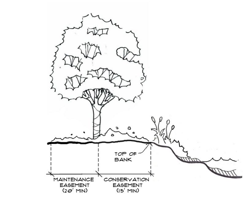
(1)
All new development is to control drainage, including roof drainage.
(2)
Upland sites shall be chosen for the location of buildings and other impervious structures.
(3)
Post-development stormwater discharge rates shall not exceed that of the pre-developed or pre-existing state. If pre-existing stormwater discharge causes adverse off-site impacts, site development shall include improvements required to mitigate all adverse off-site impacts.
(4)
Retention and detention systems must be used to retard, retain and/or detain accelerated runoff which a development generates. Water must be released from detention ponds into watercourses or wetlands at a rate and in a manner approximating the natural flow that would have occurred before development. Design capacity will be calculated considering variations between dry season and wet season water levels.
(5)
Retention/detention ponds shall be designed in accordance with the SWFWMD Basis of Review, Chapter 4, Water Quantity, and Chapter 5, Water Quality, unless it is determined by the City Engineer that conditions warrant more stringent requirements.
(6)
Retention/detention areas shall be designed so that stormwater runoff may be utilized for on-site irrigation.
(7)
Design of retention/detention ponds shall be governed by site constraints and opportunities resulting from the underlying soils and bedrock, and shall utilize state of the art engineering standards and techniques. The bank shall be sodded or landscaped with a maximum slope of 4:1. The provision for maximum slope may be waived if the developer can demonstrate that unusual hardship will be created by strict application thereof. The City Engineer may approve a steeper slope and require a protective fence or barrier.
(8)
All drainage not originating on the proposed developed land shall be kept separate from on-site drainage and shall not drain into the on-site retention area. No contours shall be altered which would adversely affect abutting properties.
(9)
Runoff shall not be discharged directly into open waters. Instead, vegetated buffers, swales, vegetated watercourses, wetlands, underground drains, catch basins, ponds, porous pavements, and similar systems for the detention, retention, treatment, and percolation of runoff shall be used, as appropriate, to increase time of concentration, decrease velocity, increase infiltration, allow suspended solids to settle, and remove pollutants.
(10)
Discharge into a public drainage system shall be governed by the regulations of the entity having jurisdiction over said system. For example, discharge to drainage facilities serving State roads shall be governed by the standards of the Drainage Manual published by the Florida Department of Transportation (FDOT), most recent edition.
(11)
Retention/detention ponds without a positive outfall may be approved if it is impractical to discharge into a public drainage system. These ponds shall be designed for a one hundred (100) year storm.
(12)
Where applicable, the use of Low Impact Development (LID) controls such as bioswales, pervious pavement, stormwater harvesting, rainwater harvesting, rain barrels and cisterns, rain gardens, etc., is encouraged to reduce the rate and volume of runoff for the protection of downstream water quality. The use of LID controls may be considered as credit toward the City's requirement for the treatment of the first one-half inch of rainfall subject to the approval of the City Engineer. To qualify for the credit, the developer shall supply calculations and methods of analysis demonstrating equivalent water quality treatment using LID.
(13)
One (1) foot of freeboard is required above high water level. Freeboard shall be defined as the distance from the top of the overflow structure up to the lowest point of top of bank, back of curb, or edge of pavement at the first upstream catch basin, whichever is lowest.
Figure 11-2: Freeboard Requirement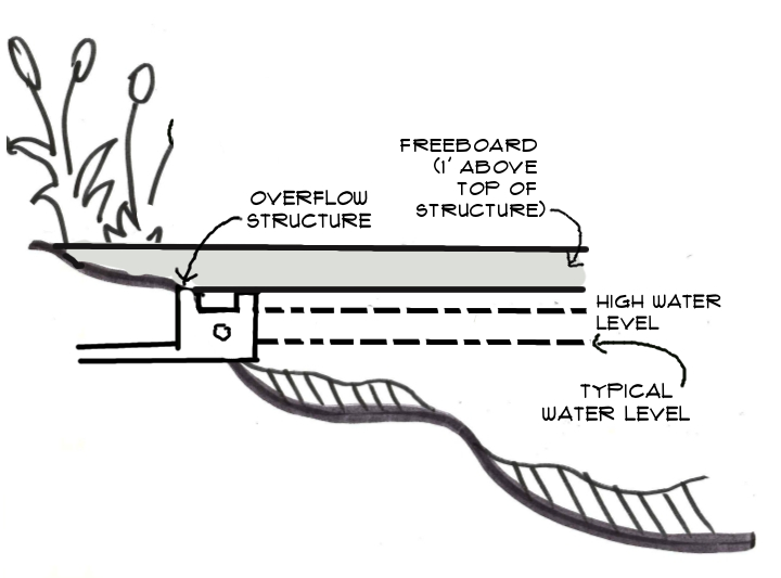
(14)
Runoff from newly developed or redeveloped parking lots shall be treated to remove oil and sediment before entering receiving waters.
(15)
Normally isolated wetlands tend to fill and overflow during floods. Flowage areas should be protected from incompatible development. The construction of roads across such areas shall be limited. For example, roads that are built shall be constructed on pilings or with adequate culverts so as not to obstruct normal flows.
(16)
Natural watercourses shall not be filled, dredged, cleared, deepened, straightened, stabilized, or otherwise altered, except in cases of overriding public interest and approved by the City Engineer.
(17)
A vegetated buffer area shall be created, or preferably retained in its natural state, along the banks of any natural watercourse, waterbody, or freshwater and saltwater wetlands pursuant to applicable standards of jurisdictional agencies. The width of the vegetated area shall be sufficient to prevent erosion, trap sediment and pollutants in overland runoff, provide access to the waterbody, and allow for periodic flooding without damage to buildings, roads, or other structures.
(18)
Wet detention systems and retention areas:
a.
Shall be designed so that shorelines are sinuous rather than straight, and so that the length of shoreline is maximized, thus offering more space for the growth of littoral vegetation (see Figure 11-3), unless approved by the City Engineer. Care shall be exercised not to create stagnant areas therein.
b.
A wet pond must be able to maintain a permanent pool. If the soil at the site is not sufficiently impermeable to prevent excessive seepage, as determined by the City Engineer, construction of an impermeable liner or other soil modifications will be required.
c.
Decorative fountains shall be included in all wet ponds, unless the DCO allows the substitution of a comparable aesthetic or functional enhancement to the pond for the fountain. The falling water from the fountain must be centered in the pond, away from the shoreline.
d.
Vegetation is an integral part of a wet pond system. The use of wetland and/or aquatic plants is required at the edge of all ponds to provide pollutant filtration, reduce algal growth, limit erosion and increase the aesthetic value of the pond. Except in maintenance easements, turf grass shall not be used. The planting requirement may be reduced or waived by the DCO if substituted by a comparable aesthetic or functional treatment.
Figure 11-3: Retention Area with Sinuous Shoreline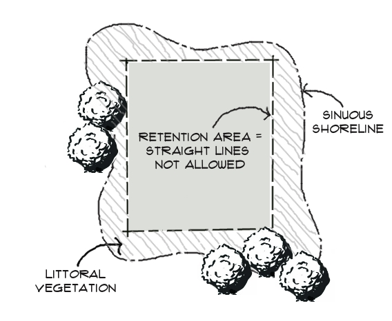
(19)
Although the use of wetlands for storing and purifying water is encouraged, care shall be taken not to overload their capacity to perform this function, thereby harming the wetland and transitional vegetation. Wetlands shall not be damaged or replaced by the construction of detention ponds unless equivalent wetlands are created as a replacement. Appropriate replacement ratios and the types of wetlands to be created shall be determined by the agency having jurisdiction at the time of permitting. Mitigative measures, including but not limited to, wetlands recreation, as required by the FDEP, the USACE, Pinellas County, the SWFWMD, and other regulatory agencies, will be required as a condition of approval if construction is to take place upon soils having constraints for development.
(20)
Retention/detention areas in residential subdivisions shall have direct access from public rights-of-way. The stormwater system shall be platted as part of the common areas to be the responsibility of the Homeowners Association (HOA). The HOA documents shall clearly specify the HOA's maintenance responsibility for the stormwater system.
(21)
Where a sidewalk or public right-of-way is immediately adjacent to a retention/detention pond, a guardrail or other protective device shall be installed along the sidewalk or right-of-way. Such device shall be required only where the retention pond and sidewalk or right-of-way are abutting. The City Engineer may waive such requirements when side slopes are less than a 4:1 ratio.
Figure 11-4: Sidewalk Abutting Steep Stormwater Slope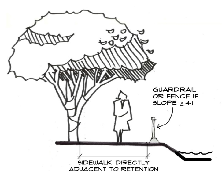
(22)
Ancillary retention areas shall be:
a.
located adjacent to the site benefiting from such improvements, and
b.
under the same ownership as the primary use or designated as a drainage easement under a recordable agreement between the property owners of both parcels. Such agreement shall clearly designate the liability and responsibility for maintenance and shall be subject to City approval prior to recording.
(23)
All impervious areas shall have a minimum slope of three-tenths (0.3) percent.
G.
Co-location of stormwater system with other site improvements
(1)
The use of drainage facilities and vegetated buffer zones for a combination of open space, recreation, and conservation areas is a priority of the City.
(2)
Parking areas may be used as retention areas by the use of restrictive inlets or restrictive pipe sizes. The parking area shall have sufficient retention area, and the discharge rate shall conform to all City requirements. A maximum water level of six (6) inches above grade will be allowed.
(3)
Proposed building design may allow for a certain amount of water retention or storage on the roof area.
(4)
Underground retention/detention areas (vaults) with an outfall to a public drainage facility are permissible if the requirements of this Section are otherwise met.
H.
Design standards for storm sewers, drainage ditches, and swales - All stormwater facilities in City rights-of-way or easements shall meet the following City standards:
(1)
All pipes shall be reinforced in concrete Class III and a minimum of fifteen (15) inches in diameter.
(2)
The maximum velocity for storm sewers shall be ten (10) feet per second with a minimum velocity of two (2) feet per second. The hydraulic gradient elevation shall be one (1) foot below ground elevation.
(3)
Prevention of soil erosion by stormwater shall be accomplished through control of stormwater velocity in swales and ditches. All swales and ditches shall be sodded, vegetated or lined with riprap or concrete if projected maximum stormwater velocities are greater than the maximum allowed velocity in a grassed channel. The maximum velocity in a grassed channel shall be a three and one-half (3.5) feet per second (fps). In other areas the maximum allowed stormwater velocity shall be limited by underlying soils conditions (see Table 11-1).
(4)
Existing swales and drainage ditches shall not be filled unless adequate alternative provisions are made for conveyance of water.
(5)
All intermittent watercourses, such as swales, shall be vegetated.
(6)
Artificial watercourses shall be designed, considering the soil type, so that the velocity of flow is low enough to prevent erosion.
11.2.3 - Compliance
Property owners and contractors shall be required to implement and comply with the City's notice to contractors regarding measures to eliminate erosion and adverse drainage impacts caused by construction activity. The City may, at its discretion, inspect construction activities for compliance, as indicated in the Code of Ordinances, and impose additional requirements or penalties, as deemed necessary.
11.2.4 - Exemptions to Required Retention
A.
Other agency requirements - Areas exempt from retention by the City must meet all other agencies' requirements for stormwater.
B.
Existing drainage facilities credit - Proposed developments on sites with existing drainage facilities will be given credit toward the retention/detention and treatment requirements, however; at a minimum, treatment of runoff for the first one-half inch of rainfall from the contributing area shall be required as a condition of a DO.
C.
Municipal separate storm sewer system (MS4) - On-site retention and treatment shall not be exempted for those businesses and industries that have the potential for adverse environmental impact on the City's Municipal Separate Storm Sewer System (MS4). These businesses may include, but are not limited to, industries requiring coverage under the Multisector General Permit or those requiring an Individual Permit under the guidelines of the EPA's National Pollution Discharge Elimination System (NPDES).
11.5.1 - Scope
The provisions of Section 11.5 through 11.20, including all subsections, shall apply to all development that is wholly within or partially within a flood hazard area, including but not limited to the subdivision of land; filling, grading, and other site improvements and utility installations; construction, alteration, remodeling, enlargement, improvement, replacement repair, relocation or demolition of buildings, structures, and facilities that are exempt from the Florida Building Code; placement, installation, or replacement of tanks; placement of recreational vehicles; installation of swimming pools; and any other development.
11.5.2 - Intent
The purpose of Sections 11.5 through 11.20, including all subsections, and the flood load and flood resistant construction requirements of the Florida Building Code are to establish minimum requirements to safeguard the public health, safety, and general welfare and to minimize public and private losses due to flooding through regulation of development in flood hazard areas to:
(1)
Minimize unnecessary disruption of commerce, access and public service during times of flooding;
(2)
Require the use of appropriate construction practices in order to prevent or minimize future flood damage;
(3)
Manage filling, grading, dredging, mining, paving, excavation, drilling operations, storage of equipment or materials, and other development which may increase flood damage or erosion potential;
(4)
Manage the alteration of flood hazard areas, watercourses, and shorelines to minimize the impact of development on the natural and beneficial functions of the floodplain;
(5)
Minimize damage to public and private facilities and utilities;
(6)
Help maintain a stable tax base by providing for the sound use and development of flood hazard areas;
(7)
Minimize the need for future expenditure of public funds for flood control projects and response to and recovery from flood events; and
(8)
Meet the requirements of the National Flood Insurance Program for community participation as set forth in the Title 44 Code of Federal Regulations, Section 59.22.
11.5.3 - Coordination with the Florida Building Code
Sections 11.5 through 11.20, including all subsections, is intended to be administered and enforced in conjunction with the Florida Building Code. Where cited, ASCE 24 refers to the edition of the standard that is referenced by the Florida Building Code.
11.5.4 - Warning
The degree of flood protection required by Sections 11.5 through 11.20, including all subsections, and the Florida Building Code, as amended by the City, is considered the minimum reasonable for regulatory purposes and is based on scientific and engineering considerations. Larger floods can and will occur. Flood heights may be increased by man-made or natural causes. Sections 11.5 through 11.20 of this Code do not imply that land outside of mapped special flood hazard areas, or that uses permitted within such flood hazard areas, will be free from flooding or flood damage. The flood hazard areas and base flood elevations contained in the Flood Insurance Study and shown on Flood Insurance Rate Maps and the requirements of Title 44 Code of Federal Regulations, Parts 59 and 60 may be revised by the Federal Emergency Management Agency, requiring this City to revise these regulations to remain eligible for participation in the National Flood Insurance Program. No guaranty of vested use, existing use, or future use is implied or expressed by compliance with Sections 11.5 through 11.20 of this Code.
(Ord. No. 2019-43, § 2, 5-21-2019)
11.5.5 - Disclaimer of Liability
Sections 11.5 through 11.20, including all subsections, shall not create liability on the part of the City or by any officer or employee thereof for any flood damage that results from reliance on this CDC or any administrative decision lawfully made thereunder.
11.6.1 - General
Where there is conflict between a general requirement in Sections 11.5 through 11.20, including all subsections, and a specific requirement in this Sections 11.5 through 11.20, including all subsections, the specific requirement shall be applicable.
11.6.2 - Areas to which this applies
Sections 11.5 through 11.20, including all subsections, shall apply to all flood hazard areas with the City, as established in Section 11.6.3.
11.6.3 - Basis for establishing flood hazard areas
The FEMA Flood Insurance Study for Pinellas County, Florida and Incorporated Areas dated August 24, 2021, and all subsequent amendments and revisions, and the accompanying Flood Insurance Rate Maps (FIRM), and all subsequent amendments and revisions to such maps, are adopted by reference as part of Section 11.5 through 11.20, including all subsections, and shall serve as the minimum basis for establishing flood hazard areas. Studies and maps that establish flood hazard areas are on file at the Community Development Department in Largo City Hall.
(Ord. No. 2024-19, § 2, 5-7-2024; Ord. No. 2025-20, § 2(Exh. A), 4-15-2025; Ord. No. 2025-08, § 35, 6-17-2025)
11.6.4 - Submission of additional data to establish flood hazard areas
To establish flood hazard areas and base flood elevations, pursuant to Section 11.9 the Floodplain Administrator may require submission of additional data. Where field surveyed topography prepared by a Florida licensed professional surveyor or digital topography accepted by the City Engineer or his/her designee indicates that ground elevations:
A.
Are below the closest applicable base flood elevation, even in areas not delineated as a special flood hazard area on a FIRM, the area shall be considered as a flood hazard area and subject to the requirements of Section 11.5 through 11.20, including all subsections, and, as applicable, the requirements of the Florida Building Code.
B.
Are above the closest applicable base flood elevation, the area shall be regulated as special flood hazard area, unless the applicant obtains a Letter of Map Change that removes the area for the special flood hazard area.
(Ord. No. 2025-20, § 2(Exh. A), 4-15-2025)
11.6.5 - Other laws
The provisions of Sections 11.5 through 11.20, including all subsections, shall not be deemed to nullify any provisions of local, state, or federal law.
11.6.6 - Abrogation and greater restrictions
Sections 11.5 through 11.20 of this Code, including all subsections, supersede any ordinance in effect for management of development in flood hazard areas. However, it is not intended to repeal or abrogate any existing Code provisions including but not limited to land development regulations, stormwater management regulations, or the Florida Building Code. In the event of a conflict between Sections 11.5 through 11.20, including all subsections, and any other regulation, the more restrictive shall govern. Sections 11.5 through 11.20, including all subsections, shall not impair any deed restriction, covenant or easement, but any land that is subject to such interests shall also be governed by Sections 11.5 through 11.20 of this Code.
(Ord. No. 2019-43, § 3, 5-21-2019)
11.6.7 - Interpretation
In the interpretation and application of Sections 11.5 through 11.20, included all subsections, all provisions shall be:
A.
Considered as minimum requirements;
B.
Liberally construed in favor of the City; and
C.
Deemed neither to limit nor repeal any other powers granted to the City under state statutes.
11.7.1 - Designation
The Building Official is designated as the Floodplain Administrator. The Floodplain Administrator may delegate performance of certain duties to other City employees.
11.7.2 - General
The Floodplain Administrator is authorized and directed to administer and enforce the provisions of Sections 11.5 through 11.20, including all subsections. The Floodplain Administrator shall have the authority to render interpretations of Sections 11.5 through 11.20, including all subsections, consistent with the intent and purpose of Sections 11.5 through 11.20, including all subsections, and may establish policies and procedures in order to clarify the application of their provisions. Such interpretations, policies, and procedures shall not have the effect of waiving requirements specifically provided in Section 11.5 through 11.20, including all subsections, without the granting of a variance pursuant to Section 11.11.
(Ord. No. 2025-20, § 2(Exh. A), 4-15-2025)
11.7.3 - Applications and permits
The Floodplain Administrator, in coordination with other pertinent offices of the City, shall:
A.
Review applications and plans to determine whether proposed new development will be located in flood hazard areas;
B.
Review applications for modification of any existing development in flood hazard areas for compliance with the requirements of Sections 11.5 through 11.20, including all subsections;
C.
Interpret flood hazard area boundaries where such interpretation is necessary to determine the exact location of boundaries; a person contesting the determination shall have the opportunity to appeal the interpretation;
D.
Provide available flood elevation and flood hazard information;
E.
Determine whether additional flood hazard data shall be obtained from other sources or shall be developed by an applicant;
F.
Review applications to determine whether proposed development will be reasonably safe from flooding;
G.
Issue development permits for development other than buildings and structures that are subject to the Florida Building Code, including buildings, structures and facilities exempt from the Florida Building Code, when compliance with Sections 11.5 through 11.20, is demonstrated, or disapprove the same in the event of noncompliance; and
H.
Coordinate with and provide comments to the Building Official to assure that applications, plan reviews, and inspections for buildings and structures in flood hazard areas comply with the applicable provisions of Sections 11.5 through 11.20, including all subsections.
(Ord. No. 2019-43, § 4, 5-21-2019)
11.7.4 - Substantial improvement and substantial damage determinations
For applications for building permits to improve buildings and structures, including alterations, movement, enlargement, replacement, repair, change of occupancy, additions, rehabilitations, renovations, substantial improvements, repairs of substantial damage, and any other improvement of or work on such buildings and structures, the Floodplain Administrator, in coordination with the Building Official, shall:
A.
Estimate the market value, or require the applicant to obtain an appraisal of the market value prepared by a qualified independent appraiser, of the building or structure before the start of construction of the proposed work; in the case of repair, the market value of the building or structure shall be the market value before the damage occurred and before any repairs are made;
B.
Compare the cost to perform the improvement, the cost to repair a damaged building to its pre-damaged condition, or the combined costs of improvements and repairs, if applicable, to the market value of the building or structure;
C.
Determine and document whether the proposed work constitutes substantial improvement or repair of substantial damage; and
D.
Notify the applicant if it is determined that the work constitutes substantial improvement or repair of substantial damage and that compliance with the flood resistant construction requirements of the Florida Building Code and Sections 11.5 through 11.20, including all subsections, is required.
(Ord. No. 2025-20, § 2(Exh. A), 4-15-2025)
11.7.5 - Modifications of the strict application of the requirements of the Florida Building Code
The Floodplain Administrator shall review requests submitted to the Building Official that seek approval to modify the strict application of the flood load and flood resistant construction requirements of the Florida Building Code to determine whether such requests require the granting of a variance pursuant to Section 11.11.
11.7.6 - Notices and orders
The Floodplain Administrator shall coordinate with appropriate local agencies for the issuance of all necessary notices or orders to ensure compliance with Sections 11.5 through 11.20, including all subsections.
11.7.7 - Inspections
The Floodplain Administrator shall make the required inspections as specified in Section 11.10 for development that is not subject to the Florida Building Code, including buildings, structures and facilities exempt from the Florida Building Code. The Floodplain Administrator shall inspect flood hazard areas to determine if development is undertaken without issuance of the appropriate permits.
11.7.8 - Other duties of the Floodplain Administrator
The Floodplain Administrator shall have other duties, including but not limited to:
(1)
Establish, in coordination with the Building Official, procedures for administering and documenting determinations of substantial improvement and substantial damage made pursuant to Section 11.7.4;
(2)
Require that applicants proposing alteration of a watercourse notify adjacent communities and the Florida Division of Emergency Management, State Floodplain Management Office, and submit copies of such notifications to the Federal Emergency Management Agency (FEMA);
(3)
Require applicants who submit hydrologic and hydraulic engineering analyses to support permit applications to submit to FEMA the data and information necessary to maintain the Flood Insurance Rate Maps if the analyses proposed to change base flood elevations, flood hazard area boundaries, or floodway designations; such submissions shall be made within 6 months of such data becoming available;
(4)
Review required design certifications and documentation of elevations specified by Sections 11.5 through 11.20, including all subsections, and the Florida Building Code to determine that such certifications and documentations are complete;
(5)
Notify the Federal Emergency Management Agency when the corporate boundaries of the City are modified; and
(6)
Advise applicants for new buildings and structures, including substantial improvements that are located in any unit of the Coastal Barrier Resources System established by the Coastal Barrier Resources Act (Pub. L. 97-348) and the Coastal Barrier Improvement Act of 1990 (Pub. L. 101-591) that federal flood insurance is not available on such construction; areas subject to this limitation are identified on Flood Insurance Rate Maps as "Coastal Barrier Resource System Areas" and "Otherwise Protected Areas."
(Ord. No. 2019-43, § 5, 5-21-2019)
11.7.9 - Floodplain management records
Regardless of any limitation on the period required for retention of public records, the Floodplain Administrator shall maintain and permanently keep and make available for public inspection all records that are necessary for the administration of Sections 11.5 through 11.20, including all subsections, and the flood resistant construction requirements of the Florida Building Code, including Flood Insurance Rate Maps; Letters of Map Change; records of issuance of permits and denial of permits; determinations of whether proposed work constitutes substantial improvement or repair of substantial damage; required design certifications and documentation of elevations specified by the Florida Building Code and Sections 11.5 through 11.20, including all subsections; notifications to adjacent communities, FEMA, and the state related to alterations of watercourses; assurances that the flood carrying capacity of altered watercourses will be maintained; documentation related to appeals and variances, including justification for issuance or denial; and records of enforcement actions taken pursuant to Sections 11.5 through 11.20, including all subsections, and the flood resistant construction requirements of the Florida Building Code. These records shall be available for public inspection at the Community Development Department in Largo City Hall.
(Ord. No. 2025-20, § 2(Exh. A), 4-15-2025; Ord. No. 2025-08, § 36, 6-17-2025)
11.8.1 - Permits required
Any owner or owner's authorized agent (hereinafter "applicant") who intends to undertake any development activity within the scope Sections 11.5 through 11.20, including all subsections, including buildings, structures and facilities exempt from the Florida Building Code, which is wholly within or partially within any flood hazard area shall first make application to the Floodplain Administrator, and the Building Official if applicable, and shall obtain the required permit(s) and approval(s). No such permit or approval shall be issued until compliance with the requirements of Sections 11.5 through 11.20, including all subsections and all other applicable codes and regulations has been satisfied.
(Ord. No. 2019-43, § 6, 5-21-2019)
11.8.2 - Development permits
Development permits shall be issued pursuant to Sections 11.5 through 11.20, including all subsections, any development activities not subject to the requirements of the Florida Building Code, including buildings, structures and facilities exempt from the Florida Building Code. Depending on the nature and extent of proposed development that includes a building or structure, the Floodplain Administrator may determine that a development permit is required in addition to a building permit.
(Ord. No. 2019-43, § 6, 5-21-2019)
11.8.3 - Buildings, structures and facilities exempt from the Florida Building Code
Pursuant to the requirements of federal regulation for participation in the National Flood Insurance Program (44 C.F.R. Parts 59 and 60), development permits shall be required for the following buildings, structures and facilities that are exempt from the Florida Building Code and any further exemptions provided by law, which are subject to the requirements of Sections 11.5 through 11.20, including all subsections:
A.
Railroads and ancillary facilities associated with the railroad.
B.
Nonresidential farm buildings on farms, as provided in Section 604.50, F.S.
C.
Temporary buildings or sheds used exclusively for construction purposes.
D.
Mobile or modular structures used as temporary offices.
E.
Those structures or facilities of electric utilities, as defined in Section 366.02, F.S., which are directly involved in the generation, transmission, or distribution of electricity.
F.
Chickees constructed by the Miccosukee Tribe of Indians of Florida or the Seminole Tribe of Florida. As used in this paragraph, the term "chickee" means an open-sided wooden hut that has a thatched roof of palm or palmetto or other traditional materials, and that does not incorporate any electrical, plumbing, or other non-wood features.
G.
Family mausoleums not exceeding 250 square feet in area which are prefabricated and assembled on site or pre-assembled and delivered on site and have walls, roofs, and a floor constructed of granite, marble, or reinforced concrete.
H.
Temporary housing provided by the Department of Corrections to any prisoner in the state correctional system.
I.
Structures identified in Section 553.73(10)(k), F.S., are not exempt from the Florida Building Code if such structures are located in flood hazard areas established on Flood Insurance Rate Maps.
(Ord. No. 2019-43, § 6, 5-21-2019)
11.8.4 - Application for a permit or approval
To obtain a development permit the applicant shall first file an application in writing on a form furnished by the Largo Building Department. The information provided shall:
A.
Identify and describe the development to be covered by the permit or approval.
B.
Describe the land on which the proposed development is to be conducted by legal description, street address or similar description that will readily identify and definitively locate the site.
C.
Indicate the use and occupancy for which the proposed development is intended.
D.
Be accompanied by a site plan or construction documents as specified in Section 11.9.
E.
State the valuation of the proposed work.
F.
Be signed by the applicant or the applicant's authorized agent.
G.
Give such other data and information as required by the Floodplain Administrator.
(Ord. No. 2019-43, § 6, 5-21-2019)
11.8.5 - Validity of permit or approval
The issuance of a development permit pursuant to Sections 11.5 through 11.20, including all subsections, shall not be construed to be a permit for, or approval of, any violation of Sections 11.5 through 11.20, and including all subsections, the Florida Building Code, or any other portion of the Comprehensive Development Code or the Largo City Code. The issuance of permits based on submitted applications, construction documents, and other information shall not prevent the Floodplain Administrator from requiring the correction of errors and omissions.
(Ord. No. 2019-43, § 6, 5-21-2019)
11.8.6 - Expiration
A development permit shall become invalid unless the work authorized by such permit is commenced within one hundred eighty (180) days after its issuance, or if the work authorized is suspended or abandoned for a period of one hundred eighty (180) days after the work commences. Extensions for periods of not more than one hundred eighty (180) days each shall be requested in writing and justifiable cause shall be demonstrated.
(Ord. No. 2019-43, § 6, 5-21-2019)
11.8.7 - Suspension or revocation
The Floodplain Administrator is authorized to suspend or revoke a development permit if the permit was issued in error, on the basis of incorrect, inaccurate or incomplete information, or in violation of Sections 11.5 through 11.20, including all subsections, or any other provision of the Comprehensive Development Code or the Largo City Code.
(Ord. No. 2019-43, § 6, 5-21-2019)
11.8.8 - Other permits required
Floodplain development permits and building permits shall include a condition that all other applicable state or federal permits be obtained before commencement of the permitted development, including but not limited to the following:
A.
The Southwest Florida Water Management District; Section 373.036, F.S.
B.
Florida Department of Health for on-site sewage treatment and disposal systems; Section 381.0065, F.S. and Chapter 64E-6, F.A.C.
C.
Florida Department of Environmental Protection for construction, reconstruction, changes, or physical activities for shore protection or other activities seaward of the coastal construction control line; Section 161.141, F.S.
D.
Florida Department of Environmental Protection for activities subject to the Joint Coastal Permit; Section 161.055, F.S.
E.
Florida Department of Environmental Protection for activities that affect wetlands and alter surface water flows, in conjunction with the U.S. Army Corps of Engineers; Section 404 of the Clean Water Act.
F.
Federal permits and approvals.
(Ord. No. 2019-43, § 6, 5-21-2019)
11.9.1 - Information for development in flood hazard areas
The site plan or construction documents for any development subject to the requirements of Sections 11.5 through 11.20, including all subsections, shall be drawn to scale and shall include, as applicable to the proposed development:
A.
Delineation of flood hazard areas, floodway boundaries and flood zone(s), base flood elevation(s), and ground elevations if necessary for review of the proposed development.
B.
Where base flood elevations or floodway data are not included on the FIRM or in the Flood Insurance Study, they shall be established in accordance with Section 11.9.2(B) or (C) of this ordinance.
C.
Where the parcel on which the proposed development will take place will have more than fifty (50) lots or is larger than five (5) acres and the base flood elevations are not included on the FIRM or in the Flood Insurance Study, such elevations shall be established in accordance with Section 11.9.2(A).
D.
Location of the proposed activity and proposed structures, and locations of existing buildings and structures; in coastal high hazard areas, new buildings shall be located landward of the reach of mean high tide.
E.
Location, extent, amount, and proposed final grades of any filling, grading, or excavation.
F.
Where the placement of fill is proposed, the amount, type, and source of fill material; compaction specifications; a description of the intended purpose of the fill areas; and evidence that the proposed fill areas are the minimum necessary to achieve the intended purpose.
G.
Delineation of the Coastal Construction Control Line or notation that the site is seaward of the coastal construction control line, if applicable.
H.
Extent of any proposed alteration of sand dunes or mangrove stands, provided such alteration is approved by the Florida Department of Environmental Protection.
I.
Existing and proposed alignment of any proposed alteration of a watercourse.
The Floodplain Administrator is authorized to waive the submission of site plans, construction documents, and other data that are required in Sections 11.5 through 11.20, but that are not required to be prepared by a registered design professional if it is found that the nature of the proposed development is such that the review of such submissions is not necessary to ascertain compliance with Sections 11.5 through 11.20, including all subsections.
(Ord. No. 2019-43, § 7, 5-21-2019)
11.9.2 - Information in flood hazard areas without base flood elevations (approximate Zone A)
Where flood hazard areas are delineated in the FIRM and base flood elevation data have not been provided, the Floodplain Administrator shall:
A.
Require the applicant to include base flood elevation data prepared in accordance with currently accepted engineering practices.
B.
Obtain, review, and provide to applicants base flood elevation and floodway data available from a federal or state agency or other source or require the applicant to obtain and use base flood elevation and floodway data available from a federal or state agency or other source.
C.
Where base flood elevation and floodway data are not available from another source, where the available data are deemed by the Floodplain Administrator to not reasonably reflect flooding conditions, or where the available data are known to be scientifically or technically incorrect or otherwise inadequate:
(1)
Require the applicant to include base flood elevation data prepared in accordance with currently accepted engineering practices; or
(2)
Specify that the base flood elevations is two (2) feet above the highest adjacent grade at the location of the development, provided there is no evidence indicating flood depths have been or may be greater than two (2) feet.
D.
Where the base flood elevation data is to be used to support a Letter of Map Change from FEMA, advise the applicant that the analyses shall be prepared by a Florida licensed engineer in a format required by FEMA, and that it shall be the responsibility of the applicant to satisfy the submittal requirements and pay the processing fees.
11.9.3 - Additional analyses and certifications
As applicable to the location and nature of the proposed development activity, and in addition to the requirements of Sections 11.5 through 11.20, including all subsections, the applicant shall have the following analyses signed and sealed by a Florida licensed engineer for submission with the site plan and construction documents:
A.
For development activities proposed to be located in a regulatory floodway, a floodway encroachment analysis that demonstrates that the encroachment of the proposed development will not cause any increase in base flood elevations; where the applicant proposes to undertake development activities that do increase base flood elevations, the applicant shall submit such analysis to FEMA as specified in Section 11.9.4 and shall submit the Conditional Letter of Map Revision, if issued by FEMA, with the site plan and construction documents.
B.
For development activities proposed to be located in a riverine flood hazard area for which base flood elevations are included in the Flood Insurance Study or on the FIRM and floodways have not been designated, hydrologic and hydraulic analyses that demonstrate that the cumulative effect of the proposed development, when combined with all other existing and anticipated flood hazard area encroachments, will not increase the base flood elevation more than one (1) foot at any point within the City. This requirement does not apply in isolated flood hazard areas identified as Zone AO or Zone AH.
C.
For alteration of a watercourse, an engineering analysis prepared in accordance with standard engineering practices which demonstrates that the flood-carrying capacity of the altered or relocated portion of the watercourse will not be decreased, and certification that the altered watercourse shall be maintained in a manner which preserves the channel's flood-carrying capacity; the applicant shall submit the analysis to FEMA as specified in Section 11.9.4.
D.
For activities that propose to alter sand dunes or mangrove stands in coastal high hazard areas (Zone V), an engineering analysis that demonstrates that the proposed alteration will not increase the potential for flood damage.
11.9.4 - Submission of additional data
When additional hydrologic, hydraulic or other engineering data, studies, and additional analyses are submitted to support an application, the applicant has the right to seek a Letter of Map Change from FEMA to change the base flood elevations, change floodway boundaries, or change boundaries of flood hazard areas shown on FIRMs, and to submit such data to FEMA for such purposes. The analyses shall be prepared by a Florida licensed engineer in a format required by FEMA. Submittal requirements and processing fees shall be the responsibility of the applicant.
11.10.1 - General
Development for which a development permit is required shall be subject to inspection.
(Ord. No. 2019-43, § 8, 5-21-2019)
11.10.2 - Development other than buildings and structures
The Floodplain Administrator shall inspect all development to determine compliance with the requirements of Sections 11.5 through 11.20, including all subsections, and the conditions of issued-development permits.
(Ord. No. 2019-43, § 8, 5-21-2019)
11.10.3 - Buildings, structures and facilities exempt from the Florida Building Code
The Floodplain Administrator shall inspect buildings, structures and facilities exempt from the Florida Building Code to determine compliance with the requirements of Sections 11.5 through 11.20, including all subsections, and the conditions of issued development permits.
(Ord. No. 2019-43, § 8, 5-21-2019)
11.10.4 - Buildings, structures and facilities exempt from the Florida Building Code, lowest floor inspection
Upon placement of the lowest floor, including basement, and prior to further vertical construction, the owner of a building, structure or facility exempt from the Florida Building Code, or the owner's authorized agent, shall submit to the Floodplain Administrator:
A.
If a design flood elevation was used to determine the required elevation of the lowest floor, the certification of elevation of the lowest floor prepared and sealed by a Florida licensed professional surveyor; or
B.
If the elevation used to determine the required elevation of the lowest floor was determined in accordance with Section 11.9.2C(2), the documentation of height of the lowest floor above highest adjacent grade, prepared by the owner or the owner's authorized agent.
(Ord. No. 2019-43, § 8, 5-21-2019)
11.10.5 - Buildings, structures and facilities exempt from the Florida Building Code, final inspection
As part of the final inspection, the owner or owner's authorized agent shall submit to the Floodplain Administrator a final certification of elevation of the lowest floor or final documentation of the height of the lowest floor above the highest adjacent grade; such certifications and documentations shall be prepared as specified in Section 11.10.4.
(Ord. No. 2019-43, § 8, 5-21-2019)
11.10.6 - Manufactured homes
The Floodplain Administrator shall inspect manufactured homes that are installed or replaced in flood hazard areas to determine compliance with the requirements of Sections 11.5 through 11.20, including all subsections, and the conditions of the issued permit. Upon placement of a manufactured home, certification of the elevation of the lowest floor shall be submitted to the Floodplain Administrator.
(Ord. No. 2019-43, § 8, 5-21-2019)
11.11.1 - General
The Planning Board shall hear and decide requests for appeals and requests for variance from the Sections 11.5 through 11.20. Pursuant to Section 553.73(5), F.S., the Planning Board shall hear and decide on requests for appeals and requests for variances from the flood resistant construction requirements of the Florida Building Code. This section does not apply to Section 3109 of the Florida Building Code. Requests for variances under this section will be heard in accordance with Chapter 4 of this Code.
(Ord. No. 2019-43, § 9, 5-21-2019)
11.11.2 - Appeals
The Planning Board shall hear and decide Level III appeals in accordance with Section 4.4 when it is alleged there is an error in any requirement, decision, or determination made by the Floodplain Administrator in the administration and enforcement of the Sections 11.5 through 11.20.
(Ord. No. 2019-43, § 9, 5-21-2019)
11.11.3 - Limitations on authority to grant variances
The Planning Board shall base its decisions on variances on technical justifications submitted by applicants, the considerations for issuance in Section 11.11.7, the conditions of issuance set forth in Section 11.11.8, and the comments and recommendations of the Floodplain Administrator and the Building Official. The Planning Board has the right to attach such conditions as it deems necessary to further the purposes and objectives of the Sections 11.5 through 11.20.
(Ord. No. 2019-43, § 9, 5-21-2019)
11.11.4 - Restrictions in floodways
A variance shall not be issued for any proposed development in a floodway if any increase in base flood elevations would result, as evidenced by the applicable analyses and certifications required in Section 11.9.3.
(Ord. No. 2019-43, § 9, 5-21-2019)
11.11.5 - Historic buildings
A variance may be issued for the repair, improvement, or rehabilitation of a historic building that is determined eligible for the exception to the flood resistant construction requirements of the Florida Building Code, Existing Building, Chapter 12 Historic Buildings, upon a determination that the proposed repair, improvement, or rehabilitation will not preclude the building's continued designation as a historic building and the variance is the minimum necessary to preserve the historic character and design of the building. If the proposed work precludes the building's continued designation as a historic building, a variance shall not be granted and the building and any repair, improvement, and rehabilitation shall be subject to the requirements of the Florida Building Code.
(Ord. No. 2019-43, § 9, 5-21-2019)
11.11.6 - Functionally dependent uses
A variance may be issued for the construction or substantial improvement necessary for the conduct of a functionally dependent use, as defined in-Sections 11.5 through 11.20, provided the variance meets the requirements of Section 11.11.4, is the minimum necessary considering the flood hazard, and all due consideration has been given to use of methods and materials that minimize flood damage during occurrence of the base flood.
(Ord. No. 2019-43, § 9, 5-21-2019)
11.11.7 - Considerations for issuance of variances
In reviewing requests for variances, the Planning Board shall consider all technical evaluations, all relevant factors, all other applicable provisions of the Florida Building Code, Sections 11.5 through 11.20, and the following:
(1)
The danger that materials and debris may be swept onto other lands resulting in further injury or damage;
(2)
The danger to life and property due to flooding or erosion damage;
(3)
The susceptibility of the proposed development, including contents, to flood damage and the effect of such damage on current and future owners;
(4)
The importance of the services provided by the proposed development to the community;
(5)
The availability of alternate locations for the proposed development that are subject to lower risk of flooding or erosion;
(6)
The compatibility of the proposed development with existing and anticipated development;
(7)
The relationship of the proposed development to the comprehensive plan and floodplain management program for the area;
(8)
The safety of access to the property in times of flooding for ordinary and emergency vehicles;
(9)
The expected heights, velocity, duration, rate of rise and debris and sediment transport of the floodwaters and the effects of wave action, if applicable, expected at the site; and
(10)
The costs of providing governmental services during and after flood conditions including maintenance and repair of public utilities and facilities such as sewer, gas, electrical and water systems, streets and bridges.
(Ord. No. 2019-43, § 9, 5-21-2019)
11.11.8 - Conditions for issuance of variances
Variances shall be issued only upon:
(1)
Submission by the applicant, of a showing of good and sufficient cause that the unique characteristics of the size, configuration, or topography of the site limit compliance with any provision of Sections 11.5 through 11.20 or the required elevation standards;
(2)
Determination by the Planning Board that:
(a)
Failure to grant the variance would result in exceptional hardship due to the physical characteristics of the land that render the lot undevelopable; increased costs to satisfy the requirements or inconvenience do not constitute hardship;
(b)
The granting of a variance will not result in increased flood heights, additional threats to public safety, extraordinary public expense, nor create nuisances, cause fraud on or victimization of the public or conflict with existing local laws and ordinances; and
(c)
The variance is the minimum necessary, considering the flood hazard, to afford relief;
(3)
Receipt of a signed statement by the applicant that the variance, if granted, shall be recorded in the Office of the Clerk of the Court in such a manner that it appears in the chain of title of the affected parcel of land; and
(4)
If the request is for a variance to allow construction of the lowest floor of a new building, or substantial improvement of a building, below the required elevation, a copy in the record of a written notice from the Floodplain Administrator to the applicant for the variance, specifying the difference between the base flood elevation and the proposed elevation of the lowest floor, stating that the cost of federal flood insurance will be commensurate with the increased risk resulting from the reduced floor elevation (up to amounts as high as $25.00 for $100.00 of insurance coverage), and stating that construction below the base flood elevation increases risks to life and property.
(Ord. No. 2019-43, § 9, 5-21-2019)
11.12.1 - Violations
Any development that is not within the scope of the Florida Building Code but that is regulated by Sections 11.5 through 11.20 that is performed without an issued permit, that is in conflict with an issued permit, or that does not fully comply with Sections 11.5 through 11.20, shall be deemed a violation. A building or structure without the documentation of elevation of the lowest floor, other required design certifications, or other evidence of compliance required by Sections 11.5 through 11.20, including all subsections, or the Florida Building Code is presumed to be a violation until such time as that documentation is provided.
(Ord. No. 2019-43, § 10, 5-21-2019)
11.12.2 - Authority
For development that is not within the scope of the Florida Building Code but that is regulated by Sections 11.5 through 11.20, including all subsections, and that is determined to be a violation, the Floodplain Administrator is authorized to serve notices of violation or stop work orders to owners of the property involved, to the owner's agent, or to the person or persons performing the work.
11.12.3 - Unlawful continuance
Any person who shall continue any work after having been served with a notice of violation or a stop work order, except such work as that person is directed to perform to remove or remedy a violation or unsafe condition, shall be subject to penalties as prescribed by law.
11.13.1 - Scope
Unless otherwise expressly stated, the words and terms used in Chapter 11 that are defined in Chapter 20 shall, have the meanings shown in Chapter 20.
11.13.2 - Terms defined in the Florida Building Code
Terms that are not defined in Chapter 20 but are defined in the Florida Building Code, shall have the meanings ascribed to them in that code.
11.13.3 - Terms not defined
Terms that are not defined in Chapter 20 shall have ordinarily accepted meanings such as the context implies.
11.14.1 - Design and construction of buildings, structures and facilities exempt from the Florida Building Code
Pursuant to Section 11.8.3, buildings, structures, and facilities that are exempt from the Florida Building Code, including substantial improvement or repair of substantial damage of such buildings, structures and facilities, shall be designed and constructed in accordance with the flood load and flood resistant construction requirements of ASCE 24. Structures exempt from the Florida Building Code that are not walled and roofed buildings shall comply with the requirements of Section 11.20.
11.14.2 - Buildings and structures seaward of the coastal construction control line
If extending, in whole or in part, seaward of the coastal construction control line and also located, in whole or in part, in a flood hazard area:
A.
Buildings and structures shall be designed and constructed to comply with the more restrictive applicable requirements of the Florida Building Code, Building Section 3109 and Section 1612 or Florida Building Code, Residential Section R322.
B.
Minor structures and non-habitable major structures as defined in Section 161.54, F.S., shall be designed and constructed to comply with the intent and applicable provisions of Sections 11.5 through 11.20 and ASCE 24.
(Ord. No. 2019-43, § 11, 5-21-2019)
11.14.3 - Florida Building Code local technical amendment; foundation design requirements for one- and two-family dwellings and townhouses in flood hazard areas
Construction documents for one- and two-family dwellings and townhouses in flood hazard areas shall include documentation prepared and sealed by a registered design professional that the foundation design accounts for site-specific flood loads.
(Ord. No. 2025-20, § 2(Exh. A), 4-15-2025)
11.15.1 - Minimum requirements
Subdivision proposals, including proposals for manufactured home parks and subdivisions, shall be reviewed to determine that:
A.
Such proposal are consistent with the need to minimize flood damage and will be reasonably safe from flooding;
B.
All public utilities and facilities such as sewer, gas, electric, communications, and water systems are located and constructed to minimize or eliminate flood damage; and
C.
Adequate drainage is provided to reduce exposure to flood hazards; in Zones AH and AO, adequate drainage paths shall be provided to guide floodwaters around and away from proposed structures.
11.15.2 - Subdivision plats
Where any portion of proposed subdivisions, including manufactured home parks subdivisions, lies within a flood hazard area, the following shall be required:
A.
Delineation of flood hazard areas, floodway boundaries and flood zones, and design flood elevations, as appropriate, shall be shown on preliminary plats;
B.
Where the subdivision has more than 50 lots or is larger than 5 acres and base flood elevations are not included on the FIRM, the base flood elevations determined in accordance with Section 11.9.2(A); and
C.
Compliance with the site improvement and utilities requirements of Section 11.16.
11.16.1 - Minimum requirements
All proposed new development shall be reviewed to determine that:
A.
Such development is consistent with the need to minimize flood damage and will be reasonably safe from flooding;
B.
All public utilities and facilities such as sewer, gas, electric, communications, and water systems are located and constructed to minimize or eliminate flood damage; and
C.
Adequate drainage is provided to reduce exposure to flood hazards; in Zones AH and AO, adequate drainage paths shall be provided to guide floodwaters around and away from proposed structures.
11.16.2 - Sanitary sewage facilities
All new and replacement sanitary sewage facilities, private sewage treatment plants (including all pumping stations and collector systems), and on-site waste disposal systems shall be designed in accordance with the standards of onsite sewage treatment and disposal systems in Chapter 64E-6, F.A.C. and ASCE 24 Chapter 7 to minimize or eliminate infiltration of floodwaters into the systems.
11.16.3 - Water supply facilities
All new and replacement water supply facilities shall be designed in accordance with the water well construction standards in Chapter 62-532.500, F.A.C. and ASCE 24 Chapter 7 to minimize or eliminate infiltration of floodwaters into the system.
11.16.4 - Limitations on sites in regulatory floodways
No development, including but not limited to site improvements, and land disturbing activity involving fill or regrading, shall be authorized in the regulatory floodway unless the floodway encroachment analysis required in Section 11.9.3(A) demonstrates that the proposed development or land disturbing activity will not result in any increase in the base flood elevation.
11.16.5 - Limitations on placement of fill
Subject to the limitations of Sections 11.5 through 11.20, including all subsections, fill shall be designed to be stable under conditions of flooding including rapid rise and rapid drawdown of floodwater, prolonged inundation, and protection against flood-related erosion and scour. In addition to these requirements, if intended to support buildings and structures (Zone A only), fill shall comply with the requirements of the Florida Building Code.
11.16.6 - Limitations on sites in coastal high hazard areas (Zone V)
In coastal high hazard areas, alteration of sand dunes and mangrove stands shall be permitted only if such alteration is approved by the Florida Department of Environmental Protection and only if the engineering analysis required by Section 11.9.3(D) demonstrates that the proposed alteration will not increase the potential for flood damage. Construction or restoration of dunes under or around elevated buildings and structures shall comply with Section 11.20.8(C).
11.17.1 - General
All manufactured homes installed in flood hazard areas shall be installed by an installer that is licensed pursuant to Section 320.8249, F.S., and shall comply with the requirements of Chapter 15C-1, F.A.C. and the requirements of Sections 11.5 through 11.20. If located seaward of the coastal construction control line, all manufactured homes shall comply with the more restrictive of the applicable requirements.
(Ord. No. 2019-43, § 12, 5-21-2019)
11.17.2 - Foundations
All new manufactured homes and replacement manufactured homes installed on permanent, reinforced foundations that:
A.
In flood hazard areas (Zone A) other than coastal high hazard areas, are designed in accordance with the foundation requirements of the Florida Building Code, Residential Section R322.2 and Sections 11.5 through 11.20, including all subsections.
B.
In coastal high hazard areas (Zone V), are designed in accordance with the foundation requirements of the Florida Building Code, Residential Section R322.3 and Sections 11.5 through 11.20, including all subsections.
(Ord. No. 2025-20, § 2(Exh. A), 4-15-2025)
11.17.3 - Anchoring
All new manufactured homes and replacement manufactured homes shall be installed using methods and practices which minimize flood damage and shall be securely anchored to an adequately anchored foundation system to resist flotation, collapse or lateral movement. Methods of anchoring include, but are not limited to, use of over-the-top or frame ties to ground anchors. This anchoring requirement is in addition to applicable state and local anchoring requirements for wind resistance.
(Ord. No. 2025-20, § 2(Exh. A), 4-15-2025)
11.17.4 - Elevation
Manufactured homes that are placed, replaced, or substantially improved shall be elevated such that the bottom of the frame of the manufactured home is at or above the elevation required, as applicable to the flood hazard area, in the Florida Building Code, Residential Section R322.2 (Zone A) or Section R322.3 (Zone V).
(Ord. No. 2025-20, § 2(Exh. A), 4-15-2025)
11.17.5 - Enclosures
Enclosed areas below elevated manufactured homes shall comply with the requirements of the Florida Building Code, Residential Section R322.2 or R322.3 for such enclosed areas, as applicable to the flood hazard area.
(Ord. No. 2025-20, § 2(Exh. A), 4-15-2025)
11.17.6 - Utility equipment
Utility equipment that serves manufactured homes, including electric, heating, ventilation, plumbing, and air conditioning equipment and other service facilities, shall comply with the requirements of the Florida Building Code, Residential Section R322, as applicable to the flood hazard area.
(Ord. No. 2025-20, § 2(Exh. A), 4-15-2025)
11.18.1 - Temporary placement
Recreational vehicles and park trailers placed temporarily in flood hazard areas shall:
(1)
Be on the site for fewer than 180 consecutive days; or
(2)
Be fully licensed and ready for highway use, which means the recreational vehicle or park model is on wheels or jacking system, is attached to the site only by quick-disconnect type utilities and security devices, and has no permanent attachments such as additions, rooms, stairs, decks and porches.
11.18.2 - Permanent placement
Recreational vehicles and park trailers that do not meet the limitations in Section 11.18.1 for temporary placement must meet the requirements of Section 11.17 for manufactured homes.
11.19.1 - Underground tanks
Underground tanks in flood hazard areas shall be anchored to prevent flotation, collapse or lateral movement resulting from hydrodynamic and hydrostatic loads during conditions of the design flood, including the effects of buoyancy assuming the tank is empty.
11.19.2 - Above-ground tanks, not elevated
Above-ground tanks that do not meet the elevation requirements of Section 11.19.3 shall:
A.
Be permitted in flood hazard areas (Zone A) other than coastal high hazard areas, provided the tanks are anchored or otherwise designed and constructed to prevent flotation, collapse or lateral movement resulting from hydrodynamic and hydrostatic loads during conditions of the design flood, including the effects of buoyancy assuming the tank is empty and the effects of flood-borne debris.
B.
Not be permitted in coastal high hazard areas (Zone V).
11.19.3 - Above-ground tanks, elevated
Above-ground tanks in flood hazard areas shall be attached to and elevated to or above the design flood elevation on a supporting structure that is designed to prevent flotation, collapse or lateral movement during conditions of the design flood. Tank-supporting structures shall meet the foundation requirements of the applicable flood hazard area.
11.19.4 - Tank inlets and vents
Tank inlets, fill openings, outlets and vents shall be:
A.
At or above the design flood elevation or fitted with covers designed to prevent the inflow if floodwater or outflow of the contents of the tanks during conditions of the design flood; and
B.
Anchored to prevent lateral movement resulting from hydrodynamic and hydrostatic loads, including the effects of buoyancy, during conditions of the design flood.
11.20.1 - General requirements for other development
All development, including man-made changes to improved or unimproved real estate for which specific provisions are not specified in Sections 11.5 through 11.20, including all subsections, or the Florida Building Code, shall:
A.
Be located and constructed to minimize flood damage;
B.
Meet the limitations of Section 11.16.4 if located in a regulated floodway;
C.
Be anchored to prevent flotation, collapse or lateral movement resulting from hydrostatic loads, including the effects of buoyancy, during conditions of the design flood;
D.
Be constructed of flood damage-resistant materials; and
E.
Have mechanical, plumbing, and electrical systems above the design flood elevation or meet the requirements of ASCE 24, except that minimum electric service required to address life safety and electric code requirements is permitted below the design flood elevation provided it conforms to the provisions of the National Electrical Code of the Building Code of wet locations.
11.20.2 - Fences in regulated floodways
Fences in regulated floodways that have the potential to block the passage of floodwaters, such as stockade fences and wire mesh fences, shall meet the requirements of Section 11.16.4.
11.20.3 - Retaining walls, sidewalks and driveways in regulated floodways
Retaining walls and sidewalks and driveways that involve the placement of fill in regulated floodways shall meet the requirements of Section 11.16.4.
11.20.4 - Roads and watercourse crossings in regulated floodways
Roads and watercourse crossings, including roads, bridges, culverts, low-water crossings and similar means for vehicles or pedestrians to travel from one side of a watercourse to the other side, that encroach into regulated floodways shall meet the requirements of Section 11.16.4. Alteration of a watercourse that is part of a road or watercourse crossing shall meet the requirements of Section 11.9.3(C).
11.20.5 - Concrete slabs used as parking pads, enclosure floors, landings, decks, walkways, patios and similar nonstructural uses in coastal high hazard areas (Zone V)
In coastal high hazard areas, concrete slabs used as parking pads, enclosure floors, landings, decks, walkways, patios and similar nonstructural uses are permitted beneath or adjacent to buildings and structures provided the concrete slabs are designed and constructed to be:
(1)
Structurally independent of the foundation system of the building or structure;
(2)
Frangible and not reinforced, so as to minimize debris during flooding that is capable of causing significant damage to any structure; and
(3)
Have a maximum slab thickness of not more than four (4) inches.
11.20.6 - Decks and patios in coastal high hazard areas (Zone V)
In addition to the requirements of the Florida Building Code, in coastal high hazard areas decks and patios shall be located, designed, and constructed in compliance with the following:
A.
A deck that is structurally attached to a building or structure shall have the bottom of the lowest horizontal structural member at or above the design flood elevation and any supporting members that extend below the design flood elevation shall comply with the foundation requirements that apply to the building or structure, which shall be designed to accommodate any increased loads resulting from the attached deck.
B.
A deck or patio that is located below the design flood elevation shall be structurally independent from buildings or structures and their foundation systems, and shall be designed and constructed either to remain intact and in place during design flood conditions or to break apart into small pieces to minimize debris during flooding that is capable of causing structural damage to the building or structure or to adjacent buildings and structures.
C.
A deck or patio that has a vertical thickness of more than twelve (12) inches or that is constructed with more than the minimum amount of fill necessary for site drainage shall not be approved unless an analysis prepared by a qualified registered design professional demonstrates no harmful diversion of floodwaters or wave runup and wave reflection that would increase damage to the building or structure or to adjacent buildings and structures.
D.
A deck or patio that has a vertical thickness of twelve (12) inches or less and that is at natural grade or on nonstructural fill material that is similar to and compatible with local soils and is the minimum amount necessary for site drainage may be approved without requiring analysis of the impact on diversion of floodwaters or wave runup and wave reflection.
11.20.7 - Other development in coastal high hazard areas (Zone V)
In coastal high hazard areas, development activities other than buildings and structures shall be permitted only if also authorized by the appropriate federal, state or local authority; if located outside the footprint of, and not structurally attached to, buildings and structures; and if analyses prepared by qualified registered design professionals demonstrate no harmful diversion of floodwaters or wave runup and wave reflection that would increase damage to adjacent buildings and structures. Such other development activities include but are not limited to:
A.
Bulkheads, seawalls, retaining walls, revetments, and similar erosion control structures;
B.
Solid fences and privacy walls, and fences prone to trapping debris, unless designed and constructed to fail under flood conditions less than the design flood or otherwise function to avoid obstruction of floodwaters; and
C.
On-site sewage treatment and disposal systems defined in 64E-6.002, F.A.C., as filled systems or mound systems.
11.20.8 - Nonstructural fill in coastal high hazard areas (Zone V)
In coastal high hazard areas:
A.
Minor grading and the placement of minor quantities of nonstructural fill shall be permitted for landscaping and for drainage purposes under and around buildings.
B.
Nonstructural fill with finished slopes that are steeper than one unit vertical to five units horizontal shall be permitted only if an analysis prepared by a qualified registered design professional demonstrates no harmful diversion of floodwaters or wave runup and wave reflection that would increase damage to adjacent buildings and structures.
C.
Where authorized by the Florida Department of Environmental Protection or applicable local approval, sand dune construction and restoration of sand dunes under or around elevated buildings are permitted without additional engineering analysis or certification of the diversion of floodwater or wave runup and wave reflection if the scale and location of the dune work is consistent with local beach-dune morphology and the vertical clearance is maintained between the top of the sand dune and the lowest horizontal structural member of the building.
(Ord. No. 2019-43, § 13, 5-21-2019)