
Largo City Zoning Code
CHAPTER 3
THE DEVELOPMENT REVIEW PROCESS
Section 3.6 - Level II, Phased Development Site Plan
"Phased Development" refers to a residential, non-residential, or mixed-use multiple building project that, by the nature of its size or function, is complex enough to require construction phasing over an extended period of time.
3.1.1 - Purpose
This chapter sets forth the application and review procedures required for the development of land in the City. The procedures are intended to facilitate the ongoing redevelopment of the City by implementing the goals, objectives, and policies of the Comprehensive Plan as well as the principles of the Strategic Plan.
3.1.2 - Applicability
No site development allowed by this CDC, including accessory and temporary uses, shall be established or enlarged, no clearing, grading, or the like shall be performed, and no structure shall be erected, constructed, or reconstructed until a site plan has been reviewed and approved in accordance with the requirements of this CDC. Although this primarily refers to exterior work, some interior alterations that result in the intensification of the use of the site, as determined by the DCO, may require site plan review and approval. Nothing herein shall relieve any applicant of the additional responsibility of seeking any other permit or development order required by any applicable statute, ordinance, or regulation.
3.1.3 - Description of the Tiered Development Review Process
Development within the City shall be reviewed and approved by the use of the following tiered process. The Tiered Development Review Process is a clear structure for development review within the City. The process is organized into a series of levels, beginning with small scale reviews, which require a brief review by staff (Level I), and culminating in Levels IV and V, which require public review and action by the City Commission in addition to staff review. (See Figure 3-1).
3.2.1 - Level I: Small Scale Review (DRC Approval Not Required)
Level I, Small Scale Review is an expedited administrative review process for small building renovations, expansions or other similar site improvements, and developments with two (2) to four (4) total dwelling units. Regardless of the total number of dwelling units, townhome (small) developments must follow Level II, Full Scale Review outlined in Section 3.4. Specific impacts of the proposed development relating to building setbacks, intensity of use, stormwater drainage obstructions, tree removal and easements are administratively reviewed to ensure that no adverse impacts will result from the proposed improvements. Issuance of a small scale approval memo is required prior to project commencement. Small scale review applies to non-residential, small-type housing, and multi-family property types. It does not apply to detached single-family residential property or accessory dwelling units (ADUs).
(Ord. No. 2025-01, § 2, 12-17-2024)
3.2.2 - Level II: Full Scale Review (DRC Approval Required)
Level II, Full Scale Review applies to the construction of new structures within the City, townhome (small) developments, and developments of five (5) or more total dwelling units, with the exception of accessory buildings, which are reviewed under the Level I review. Level II involves a full administrative review by the Development Review Committee (DRC). Issuance of a Development Order (DO) is required prior to project commencement.
(Ord. No. 2025-01, § 2, 12-17-2024)
3.2.3 - Level III: Planning Board Review (Planning Board Approval Required)
Level III Review applies to conditional uses, hardship relief requests, appeals of administrative decisions as well as development proposals where the impact on adjacent uses must be evaluated and approved by the Planning Board prior to project commencement.
(Ord. No. 2025-01, § 2, 12-17-2024)
3.2.4 - Level IV: Planning Board & City Commission Review
Level IV Review applies to amendments to the Future Land Use Map, Development Agreements, and other types of reviews listed, but not limited to, those stated in Section 4.1.3 of this document. Level IV Review includes DRC review, Planning Board and City Commission approval prior to project commencement.
3.2.5 - Level V: City Commission Review (Non-Regular Process)
Level V review encompasses recordings of plats and replats, the dedication of right-of-way or easements, the vacation of right-of-way or easements, and vested rights determinations. These issues do not require DRC review, but do require City Commission approval. Planning Board review is not typical and is only required at the discretion of the DCO.
(Ord. No. 2025-01, § 2, 12-17-2024; Ord. No. 2025-08, § 3, 6-17-2025)
3.3.1 - Level I, Applicability
Small scale review applies to non-residential, small-type housing, and multi-family property types. It does not apply to detached single-family residential properties, ADUs, or townhome (small) developments. Other than small-type housing developments between two (2) to four (4) total dwelling units, any change in use of the land must be to a similar or less intense use of land, as determined by the DCO.
(Ord. No. 2025-01, § 3, 12-17-2024)
3.3.2 - Level I, Types of Proposals Reviewed
The following types of proposals are considered to be subject to the Level I review process. Regardless of specific proposal type, no development shall be allowed to exceed the allowable cumulative total for gross floor area alterations. The total amount of allowable alterations of total gross floor area conducted/permitted on a particular property in accordance with Sections 3.3.2.B and 3.3.2.C will be computed on a cumulative basis for five (5) year periods of time. The initial five (5) year period started on November 1, 2011 and will end on November 1, 2016. At the end of each five (5) year period occurring thereafter, the cumulative total of allowable alterations that may be made to the gross square footage of buildings or structures located on a particular site that are completed in accordance with Sections 3.3.2.B and 3.3.2.C shall reset to zero. The new cumulative total gross square footage at the end of a five (5) year period shall comprise the base gross square footage, which will be applicable to any site improvements conducted within the subsequent five (5) year period.
A.
Pole or column-supported roof additions subject to all of the following:
(1)
The proposed roof may not have enclosed sides;
(2)
The roof addition must comply with all applicable setback standards; and
(3)
The roof addition must not be for the purpose of conducting a separate business on the site.
B.
Up to twenty-five (25) percent of GFA in structural alterations (small structures) - Alterations on properties with buildings or structures with a cumulative gross floor area up to 25,000 square feet, which result in a cumulative addition equal to either twenty-five (25) percent or less or 2,500 square feet or less of the gross floor area of the structure(s), whichever is less, and which comply with all applicable requirements, including, but not limited to, setback, parking and building code standards. The alteration total must comply with total allowable cumulative provisions (see Section 3.3.2).
C.
Up to ten (10) percent of the GFA in structural alterations (large structures) - Alterations on properties with buildings or structures with a cumulative gross floor area equal to 25,000 square feet or larger which result in a cumulative addition of ten (10) percent or less of the gross floor area of the building(s) or structure(s), and which comply with all applicable requirements including, but not limited to setback, parking and building code standards. The gross floor area must be under one (1) ownership and may include more than one (1) structure on a single parcel. The alteration total must comply with total allowable cumulative provisions (see Section 3.3.2).
D.
Site improvements increasing the Impervious Surface Ratio (ISR) up to twenty-five (25) percent - Site improvements including, but not limited to, minimal parking lot alterations, or the addition of walkways, patios, and decks that increase the impervious surface ratio (ISR) of the site up to the maximum permitted ISR in the applicable land use designation, but not exceeding twenty-five (25) percent or more of additional ISR. All site improvements must comply with all applicable requirements, including but not limited to, setback, parking and building code standards.
E.
Telecommunications facilities that meet the requirements of Section 15.5.5.A.
F.
Subsidiary development - Applications for subsidiary development shall be filed as an infrastructure permit and/or other required engineering permits with the Engineering Department. Subsidiary development encompasses changes to site contours or alterations, replacement or installation of site infrastructure including/as well as the following improvements:
(1)
Changes to the contour of the ground and/or where the primary use of land is extractive in nature, such as removal or deposit of earth or rock (i.e., a borrow pit). This provision does not apply to site preparation for developments subject to a DO;
(2)
Utility poles, lines, underground pipes, or other facilities required for the transmission of power or communications, excluding substations and buildings;
(3)
Sanitary sewer systems or drainage-ways, including pump stations, swales, manholes, seawalls, and bridges, but not collection or treatment facilities;
(4)
Streets, including curbs, sidewalks, catch basins, street lights, traffic-control devices, or other facilities associated with an existing right-of-way or easement;
(5)
Water systems, including mains, fire hydrants, or other facilities associated with the distribution of water; and
(6)
Filling of waterbodies.
G.
Small-type and Medium-type Housing - Small-type and medium-type housing that consist of two (2), three (3), or four (4) total dwelling units, regardless of type, and that meet the development standards in Section 8.6 will be subject to the Level I review process. Stormwater requirements for subdivisions and multi-family developments (outlined in Section 11.2.2) will not be applied. Regardless of the total number of dwelling units, townhomes (small) developments are required to follow Level II, Full Scale Review outlined in Section 3.4, but remain exempted from stormwater requirements outlined in Section 11.2.2 if they consist of four (4) or less dwelling units, unless required by the Southwest Florida Water Management District.
(Ord. No. 2025-01, § 4, 12-17-2024; Ord. No. 2025-08, § 4, 6-17-2025)
3.3.3 - Level I, Submission Requirements
The applicant shall submit as many copies of each item as required on the City's application packet. Failure to provide any of the following items or the requested number of copies shall cause the application to be deemed incomplete.
A.
Application form - The applicant shall complete the City's standard application form, including a letter describing the proposed changes. It shall be signed by the applicant and notarized. Signatures by agents of the property owners will be accepted only with proof of authorization. In a case of corporate ownership, a certified letter, written on company letterhead, stating that the representative is authorized to sign on behalf of the corporation, must be provided.
B.
Application fee - The application fee is paid in full accordance with the then current fee schedule.
C.
Site plan - Site plan submittals for Level I are not required to be prepared or signed and sealed by design professionals (such as architects, engineers and landscape architects), however all drawings subsequently submitted to the Building Division and/or Engineering Department for a Development Permit (DP) are required to meet all applicable building and engineering requirements of the CDC and any other applicable technical codes. Copies of the as-built survey, or site plan drawn to scale, must show the following information:
(1)
Street address and boundaries of subject property and any easements, with dimensions;
(2)
Locations and exterior dimensions of all existing buildings on the site, labeled to indicate present use, with a summary of total existing building coverage (in square feet); and
(3)
Locations and exterior dimensions of all proposed structural additions, labeled to indicate intended use, with a summary of total proposed additional building coverage (in square feet).
D.
Southwest Florida Water Management District (SWFWMD) permit - A SWFWMD stormwater management permit approval or letter of exemption may be required if previous surfaces are effected by the proposed improvements.
E.
Additional information, if necessary - The DCO shall have the authority to request additional information, such as architectural elevations and traffic studies, regarding any proposed changes from the applicant prior to administratively approving any small scale application.
(Ord. No. 2025-08, § 5, 6-17-2025)
3.3.4 - Level I, Administrative Review
A.
Review criteria
(1)
CDC compliance - Applications for Level I review shall be reviewed to ensure that proposed building or site alterations meet all applicable CDC requirements. Applicants for Level I review are not required to bring their entire site up to current CDC requirements, except in cases where sites do not adequately address and/or provide safe pedestrian and vehicle site circulation, or meet current ADA requirements, as determined by the DCO.
(2)
Subsidiary development - A permit may be issued for subsidiary development if the location, size, design, and operating characteristics of the proposed improvements will serve the needs of the area and will be compatible with the surrounding neighborhood. The compatibility determination is based upon the following factors:
a.
Harmony in scale, bulk, coverage, and density;
b.
The availability of necessary public facilities and utilities;
c.
The generation of traffic and the capacity of surrounding streets; and
d.
Effect upon the drainage system.
B.
Approvals
(1)
Approval by the DCO is required, which takes the form of small scale approval, rather than a Development Order (DO).
(2)
Applications for improvements involving subsidiary development are subject to review and approval by the City Engineer or his/her designee prior to approval by the DCO.
C.
Administrative relief/modification of standards
(1)
Administrative relief from development standards may be granted by the DCO as part of a Level I review. This administrative relief must be consistent with, and may not exceed the standard or the amount specifically described in Section 3.5 (Modification of Development Standards for Site Plan Approval). Administrative relief requests must be made in writing to the DCO.
(2)
When the DCO approves the Modification of Standards, he/she may prescribe appropriate conditions and safeguards in conformity with the intent and provisions of this CDC.
D.
Appeals - Nothing in this Section shall supersede the Planning Board review process or deny access to relief by the applicant. Should the applicant disagree with the decision of the DCO, or any of the conditions imposed as part of the terms under which the Modification of Standards is approved, he/she may elect to appeal the DCO's decision to the Planning Board. The Planning Board shall consider holding a hearing on the appeal. If a hearing is held, the Planning Board shall render its decision either approving, approving with conditions, or denying the appeal.
E.
Further review
(1)
Review for a Development Permit (DP) is required after approval by the DCO is issued. Applicants must meet all applicable building code and engineering requirements including, but not limited to, the requirements of Chapter 18.
(2)
Amendments to an approved project may be considered by the DCO if the amendments do not substantially alter the characteristics of the project as originally approved.
3.3.5 - Level I, Planning Board Review
Not required
3.3.6 - Level I, City Commission Review
Not Required
3.3.7 - Level I, Development Review Sequence
See Figure 3-2.
A.
Level I application submittal - The formal application shall be submitted to the DCO who shall indicate a submission date on each copy of the materials submitted. If the application is in conformance with the submission requirements of Section 3.3.3, it shall be deemed complete. The applicant shall be notified if the application is incomplete or otherwise does not meet the submission requirements within five (5) working days from receipt of the application. The date of acceptance shall be the date the application is deemed complete.
B.
Administrative review - The DCO shall review the application to ensure consistency with the review criteria requirements of Section 3.3.4. The applicant will receive written comments from this review within fifteen (15) working days of receipt of a complete application. If the application successfully meets all requirements, to the satisfaction of the DCO, a small scale approval is granted. If it does not, the applicant may choose to revise and resubmit, seek a modification of standards (see Section 3.5), or appeal to the Planning Board.
C.
Application for development permits - The applicant may apply for any required permits following small scale approval.
Figure 3-2: Level I: Small Scale Development Review Sequence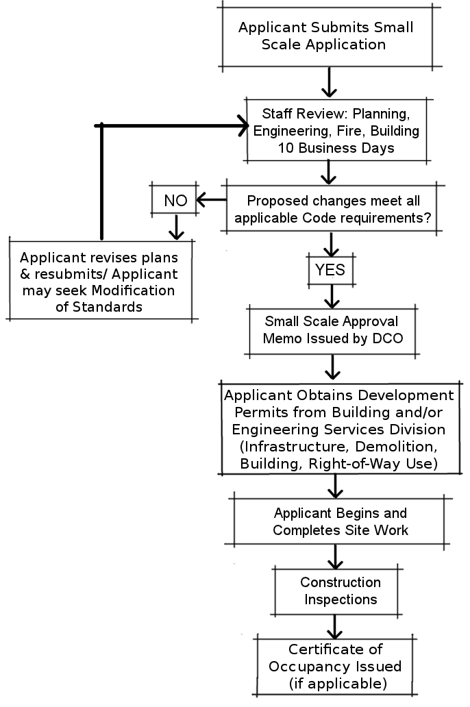
3.4.1 - Applicability
Level II, Full Scale Review applies to all new structures that exceed Level I requirements, townhome (small) developments, and developments of five (5) or more total dwelling units, within the City of Largo. It also includes improvements, such as parking lots, stormwater systems, etc., that are necessary to support these buildings and in excess of the allowable alterations reviewed under Level I.
(Ord. No. 2025-01, § 5, 12-17-2024)
3.4.2 - Level II, Type of Proposals Reviewed
A.
All new structures - Construction of new structures, with the exception of accessory buildings that do not exceed Level I requirements. This includes phased development site plans (see Section 3.6 for requirements).
B.
More than twenty-five (25) percent of the GFA in structural alterations (small structures) - Alterations of buildings or structures with a cumulative total gross floor area of 25,000 square feet or less, which result in a cumulative addition that exceeds twenty-five (25) percent or 2,500 square feet of the gross floor area of the structure(s), whichever is less, and which comply with all applicable requirements, including, but not limited to, setback, parking, and building code standards.
C.
More than ten (10) percent of the GFA in structural alterations (large structures) - Alterations of buildings or structures with a cumulative total gross floor area equal to 25,000 square feet or larger which result in cumulative addition of more than ten (10) percent of the gross floor area of the building(s) or structure(s), and which comply with all applicable requirements including, but not limited to setback, parking, and building code standards. The gross floor area must be under one (1) ownership and may include more than one (1) structure on a single parcel.
D.
Other site improvements that are over and beyond the improvements listed in Section 3.3.2, at the discretion of the DCO.
E.
Small-type and Medium-type Housing - Small-type and medium-type housing proposals that consist of five (5) or more total units, regardless of type, or are townhome (small) developments, and that meet the development standards in Section 8.6 will be subject to the Level II review process, unless required by other provisions in this CDC to use the Level III or Level IV processes.
(Ord. No. 2025-01, § 6, 12-17-2024)
3.4.3 - Level II, Submission Requirements
A.
All requirements listed in Section 3.3.3.A and 3.3.3.B.
B.
Preliminary site plan (see Section 3.7.4)
C.
Final site plan and plat (see Section 3.7.7 and Section 3.7.8)
D.
Concurrency impact questionnaire - An application for capacity-to-serve determination (Concurrency Impact Questionnaire) shall be submitted along with the final site plan.
Concurrency approval is a prerequisite of DO approval. The administration of concurrency within the City is explained in Section 3.7.3.
E.
If public improvements are included within the project, the following is required:
(1)
Public improvements cost certifications - A certification of the cost of the public improvements to be accepted by the City must be reviewed and approved by the City Engineer. This certification must include the cost of paving, drainage, and sanitary sewers to be accepted by the City.
(2)
Warranty bond - A one (1) year warranty bond equal to ten (10) percent of the cost of the improvements must be reviewed and approved by the City Engineer. The purpose of this bond is to guarantee the workmanship and materials of the public improvements accepted by the City, which shall include, but not be limited to costs associated with the removal of sediment from the stormwater collection system as a result of the construction activity. The bond form must conform to all City requirements at the time of issuance. The developer shall have up to sixty (60) days, as determined by the DCO, following written notice to complete improvements or follow-up maintenance in the event of default or failure. The City shall have the right to use the bond to secure satisfactory completion of the required improvements and stormwater collection system maintenance if the developer does not respond within the allowable time frame.
(3)
Mechanic's liens - The contractor involved with the construction and installation of the public improvements of the subdivision must submit a contractor's waiver of all claims and a final release of lien form to the City Engineer in order to provide verification that all work is complete.
F.
Additional information, if necessary - The DCO shall have the authority to request additional information, such as architectural elevations and traffic studies, regarding any proposed changes from the applicant prior to administratively approving any full scale application.
(Ord. No. 2025-08, § 6, 6-17-2025)
3.4.4 - Level II, Administrative Review
A.
Review criteria
(1)
CDC compliance - Applications for full scale review shall be reviewed to ensure that proposed building or site alterations meet all applicable CDC requirements.
(2)
Compatibility with planning documents and initiatives - The goals and policies of the Comprehensive Plan and the principles of the Strategic Plan define the community's vision for the design of new development and redevelopment. All full scale projects will be reviewed to ensure consistency with the following planning documents and initiatives:
a.
The Comprehensive Plan; and
b.
The Strategic Plan (See Section 3.7.2.A.).
(3)
Response to neighborhood concerns - The involvement and awareness of adjacent property owners in the review process is essential to identify specific issues not addressed by larger policies to ensure compatibility between existing development and new or infill development. A neighborhood information meeting (see Section 3.7.2.B) must be held at the conclusion of the preliminary site plan review, unless deemed unnecessary by the DCO, in order to acquaint adjacent property owners with the development proposal. Any recommendations provided by affected neighbors should be evaluated as part of the final site plan review process.
(4)
Concurrency adherence - A development's potential impacts on the following public facilities: potable water, sanitary sewer, solid waste, drainage, and recreation, shall be evaluated as part of the Level II review (See Section 3.7.3).
B.
Approvals - Approval by the DCO is required under Level II review, which takes the form of the issuance of a DO.
C.
Administrative relief/ modification of standards
(1)
Administrative relief from development standards may be granted by the DCO as part of a full scale review. This administrative relief must be consistent with, and may not exceed the standard or the amount specifically described in Section 3.5 (Modification of Development Standards for Site Plan Approval). Administrative relief requests must be made in writing to the DCO.
(2)
When the DCO approves the Modification of Standards, he/she may prescribe appropriate conditions and safeguards in conformity with the intent and provisions of the CDC.
D.
Appeals - Should the applicant disagree with the decision of the DCO or any of the conditions imposed as part of the terms under which the Modification of Standards is approved, he/she may elect to appeal the DCO's decision to the Planning Board. The Planning Board shall consider holding a hearing on the appeal. If a hearing is held, the Planning Board shall render its decision either approving, approving with conditions, or denying the appeal.
E.
Amending, modifying or withdrawing an application
(1)
Amendments to an approved project may be considered by the DCO if the amendments do not substantially alter the characteristics of the project as originally approved.
(2)
Modification of an application - If an applicant wishes to make modifications to a site plan submitted as part of a formal DO application, the application must either:
a.
Formally withdraw the existing application and submit a new application and all revised drawings; or
b.
Wait until the DCO issues an approved staff report containing the comments from all reviewing City departments. Applicants are advised that representations made during the review process by City staff are not final unless included in the approved staff report.
(3)
Withdrawal of an application - An applicant may submit a written request to withdraw an application for DO approval at any time after formal submission of a final site plan/preliminary plat application and prior to a final decision. A letter of withdrawal shall be submitted to the DCO.
3.4.5 - Level II, Planning Board Review
Not required
3.4.6 - Level II, City Commission Review
Not required, except for platting.
3.4.7 - Level II, Development Review Sequence
See Figure 3-3.
Figure 3-3: Level II: Full Scale Development Review Sequence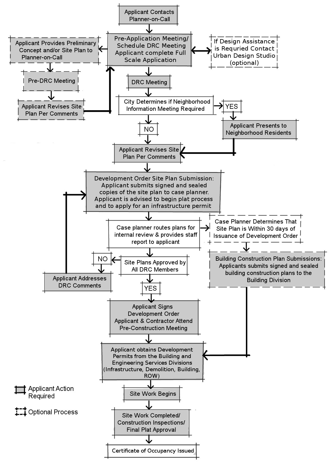
A.
Early development assistance - The City provides the following early development assistance programs:
(1)
Pre-application meeting [Required] - A pre-application meeting must be held by the applicant and City staff prior to formal application submittal (Section 3.7.6). Alternatively, the applicant may choose to participate in a Pre-DRC review.
(2)
Preliminary Development Review Committee (Pre-DRC) review [Optional] - Initial review of the project is conducted by the DRC to assist the applicant in preparing the final site plan. DRC recommendations are based on the City's ability to provide services to the property and the compatibility requirements and performance standards of this CDC.
(3)
Urban design assistance [Optional] - The City's Community Development staff provide optional assistance, within the pre-DRC and DRC process, in developing urban design solutions to specific development limitations or concerns. This assistance is intended to help applicants design projects that meet the requirements of the CDC and are compatible with City goals, objectives, and policies as represented by the Comprehensive Plan and Strategic Plan.
B.
Application submittal - The formal application shall be submitted to the DCO who shall indicate a submission date on each copy of the materials submitted. If a DO application is in conformance with the submission requirements of Section 3.4.3, it shall be deemed complete. The applicant shall be notified if the application is incomplete or otherwise does not meet the submission requirements within five (5) working days from receipt of the application. The date of acceptance shall be the date the application is deemed complete.
C.
DRC meeting - Upon submission of a complete application, the DRC will hold a meeting and inform the applicant what changes, if any, are necessary to ensure that the application will be consistent with the Comprehensive Plan, Strategic Plan, the requirements of this CDC, and any other applicable regulations. The DRC shall be scheduled to meet by a case planner within two (2) weeks of receipt of a complete application. A staff report containing interdepartmental comments for preliminary site plan review and for final site plan review shall be issued to the applicant within fifteen (15) working days of each DRC meeting.
D.
Neighborhood information meeting - A neighborhood information meeting will be held at the conclusion of the DRC review, unless the DCO determines that the project will not directly impact neighboring property owners. See Section 3.7.5 for requirements.
E.
Plan revisions - The applicant shall revise plans to address any neighborhood concerns and DRC recommendations.
F.
Development Order site plan submission - A final site plan review is conducted to ensure that comments received from the DRC review and the neighborhood information meeting have been incorporated. The final site plan review also includes a concurrency review, as described in Section 3.7.3. If a DO application is in conformance with the submission requirements of Section 3.7.7, it shall be deemed complete. The formal application for final site plan review shall be submitted to the DCO, who shall indicate a submission date on each copy of the materials submitted. The date of acceptance shall be the date the application is deemed complete. The applicant shall be notified if the application is incomplete or if it otherwise does not meet the submission requirements within fifteen (15) working days from receipt of the application. An approved final site plan is a prerequisite for final plat approval. The applicant is advised to begin the platting process once the final site plan is formally accepted by the City. Platting is a required condition of a DO, to ensure the accurate depiction of land subdivision due to the variation of lot lines, easements, or rights-of-way from previous records, due to the combination of parcels, or when parcels have not been previously platted.
G.
Development Order approval/pre-construction meeting - Final approval, resulting in the issuance of a DO, shall be based upon a final site plan that complies with all CDC standards as described on the staff report, an affirmative capacity-to-serve determination, comments from referral agencies, required meetings (neighborhood information and pre-application or Pre-DRC), and approvals by other agencies as evidenced by applicable permits. Where a referral agency or department specifies conditions to be met during the construction phase, it shall be noted on the DO, and the Certificate of Occupancy shall be withheld until compliance is verified. A pre-construction meeting shall be held following DO approval and prior to the release of an infrastructure permit or any other building permits.
H.
Application for development permits - Applicants must meet all applicable Fire Department, Building Division, and Engineering Department requirements, including but not limited to, requirements of Chapter 18 of this CDC. A Certificate of Occupancy will only be issued after completion of the work required by the DP.
I.
Submittal of an as-built drawings - An as-built drawing, properly certified, shall be submitted upon completion of the improvements for all properties subject to DO approval. A CO will only be issued after receipt of a certified as-built drawing and, if applicable, final plat approval.
J.
Submittal of final plat - Preliminary plat review and approval is a prerequisite for final plat approval. The final plat shall be approved for recording and scheduled for City Commission approval prior to the issuance of a DO. See Section 3.7.8B for a listing of plat waiver requirements.
K.
Amendment to an approved DO - Amendments to an approved DO may be accepted by the DCO if the amendments do not substantially alter the characteristics of the project as originally approved. The applicant must submit a written narrative of the changes, as well as any relevant site plan submittals that have been, or are proposed to be, altered following DO approval along with the then current fee schedule. If approved, the DCO will subsequently issue a revised DO that reflects the amendments.
3.5.1 - Purpose
This Section provides standards and procedures for the granting of administrative modifications of development standards. Modification of development standards is specifically intended to provide flexibility in the administration of standards to accommodate site specific conditions while maintaining high standards of site design, and to establish conditions to ensure compatibility where standards are modified. All applications for modifications of development standards that meet the requirements of Section 3.5 of this CDC shall be reviewed by the DCO.
(Ord. No. 2025-01, § 7, 12-17-2024)
3.5.2 - Applicability
The procedures of this section shall apply to all uses specified as allowable uses in Chapter 6 of this CDC as they relate to the following land development standards:
A.
Principal building setbacks modifications - Applicants may be allowed modifications up to twenty (20) percent of the setback requirement; however, in no case shall the side yard setback be less than five (5) feet for single-family, duplex, triplex, and quadplex developments. In addition, no modification of the required fifty (50) foot principal building setback from a natural surface water body or retained wetland shall be permitted. For properties adjacent to unpaved or unimproved alleyways, the DCO may apply modifications up to fifty (50) percent of the setback requirement on alley side.
B.
Accessory structure location standards - Applicants may be allowed modifications up to twenty (20) percent of the principal building setback requirement for accessory structures only. For accessory structures proposed on lots that are required to follow residential infill standards according to Section 8.3, the DCO may apply modifications up to fifty (50) percent of the required setback standards as shown in Table 8-2: Infill Development Standards.
C.
Fence height - Up to two (2) feet above the maximum fence height permitted by Section 16.3 in association with a fence height request, pillar and post height may be modified by a corresponding amount, provided the pillars or posts are not less than eight (8) feet apart. This provision applies to multi-family (four or more dwelling units), non-residential, and subdivisions as a whole.
D.
Parking, loading, and driveways - Up to ten (10) percent of the number of required parking spaces or two (2) spaces, whichever is greater. Accessible parking spaces shall be eligible for modification of standards, provided such modification does not reduce the number of spaces or the dimensions of spaces below the standards of the Florida Accessibility Code for Building Construction, the Americans with Disabilities Act requirements, or any other similar regulations issued thereafter. Modification of driveway and driving aisle width, parking space width and depth, and loading berth requirements shall also be considered.
E.
Landscaping and buffer yards - Locational and dimensional requirements of required landscaping areas may be reduced up to fifty (50) percent of the required width. The required quantity of plantings shall be provided but may be relocated.
F.
Lot depth - Minimum lot depth may be reduced, but not to a degree that would reduce the lot area below the minimum lot requirements of the relevant future land use district (see Table 8-1).
G.
Certain additions to principal building - Additions to existing principal buildings which do not have heating, ventilation, or air conditioning may be constructed using the accessory structure setback standards contained in Chapter 16.
H.
Air conditioning units and other similar mechanical equipment location - Air conditioning compressors and other similar mechanical equipment may be located in the rear or street side yard but shall not be located in the required front yard.
I.
Building width - Building width requirements for small-type and medium-type housing may be modified up to one (1) foot as long as it does not impede on other design requirements and has no negative effect on adjacent properties.
J.
Non-substantial modifications - Modification of the development standards listed above, of less than one (1) foot, shall be deemed to be non-substantial. The DCO shall be authorized to approve the modification at the time of the request based upon the requirements of this Section of the CDC. Non-substantial modifications must have no negative effects on adjacent properties.
(Ord. No. 2024-34, § 2, 6-18-2024; Ord. No. 2025-01, § 8, 12-17-2024; Ord. No. 2025-08, § 7, 6-17-2025)
3.5.3 - Modification of Development Standards, Submission Requirements
An application for Modification of Standards shall consist of the following:
A.
An accurate, up-to-date boundary survey - two copies, completed by a registered surveyor;
B.
A site plan - showing the complete property;
C.
Elevation drawings - showing the proposed building or building addition (if applicable); and
D.
Written modification request - including a statement of consistency with the standards established by this Section (See Section 3.5.8 and 3.5.9).
3.5.4 - Review Sequence
A.
An application for a modification of standards may be reviewed prior to application for Level I or Level II review or may be made in conjunction with Level I or Level II review.
B.
Upon acceptance of the application, the DCO shall review it and render his/her decision within fifteen (15) working days approving, approving with conditions, or denying the request. A modification of standards shall be reported in the staff comments and attached to the administrative approval.
3.5.5 - Relationship to Hardship Relief Review
Nothing in this Section shall supersede the Planning Board review process or deny access to relief by the applicant through the hardship relief review procedures (see Section 4.3).
3.5.6 - Appeals
Should the applicant disagree with the decision of the DCO or any of the conditions imposed as part of the terms under which the modification of standards is approved, he/she may elect to appeal the DCO's determination to the Planning Board. The appeal shall be reviewed by the Planning Board as set forth by this section. During the hearing, the Planning Board shall render its decision either approving, approving with conditions, or denying the appeal.
3.5.7 - Approving with Conditions
When the DCO approves the modification of standards, he/she may prescribe appropriate conditions and safeguards in conformity with the intent and provisions of this CDC. This may include, but not be limited to, some or all of the following provisions:
A.
Limiting the height, size location of a building or other structure;
B.
Designating the location of doors or windows;
C.
Requiring screening, landscaping, or other similar means to buffer or protect nearby property. The DCO may also prescribe standards for installation;
D.
Designating the size, height, location, or materials for a fence or wall;
E.
Protecting existing trees, vegetation, water resources, or other significant natural resources; and
F.
Specifying other conditions to permit development in conformity with the intent and purpose of this CDC and the Comprehensive Plan.
3.5.8 - General Standards
No modification may be granted under this Section unless the applicant demonstrates that it fulfills all of the following requirements:
A.
Comprehensive Plan compatibility - The request must be consistent with all applicable policies of the Comprehensive Plan.
B.
CDC compatibility - The request must be in conformance with any applicable substantive requirements of this CDC.
C.
Land use compatibility - The request would not result in any incompatible land uses or have a negative impact on adjacent land uses and any such impacts are mitigated by the site design.
D.
Adequate public facilities provision - The application would not overburden or otherwise adversely impact public facilities.
E.
Public health, safety and welfare consideration - The proposed modification is necessary to protect the public health, safety, and welfare.
3.5.9 - Site Specific Standards
No modification will be granted under this Section unless the applicant demonstrates the modification addresses at least one of the following:
A.
Superior alternative provision - The development will provide an alternative which will achieve the purposes of the requirement through clearly superior design.
B.
Technical impracticality - The strict application of the requirements would be technically impractical in terms of design or construction practices or existing site conditions due to conditions not directly attributable to the applicant.
C.
Lessen nonconforming conditions - The proposed modifications would lessen nonconforming conditions of the site. (See Chapter 17).
D.
Positive design elements - The proposed modification is consistent with the positive design elements of the existing adjacent development. Positive design elements shall be those identified by the General Development Standards of Chapter 8.
E.
Lessen tree removal and replacement requirements - As specified in Section 10.7.2.
3.6.1 - Purpose
The purpose of this Section is to outline the submission and procedural requirements associated with phased development site plans. Applicable projects will include large, complex projects with significant shared infrastructure needs that meet the requirements of Section 3.6.2. The requirements of this section are intended to facilitate the provision of a unified site layout that accounts for the overall mitigation of site impacts in an efficient manner, consistent with the requirements of this CDC.
3.6.2 - Applicability
Phased development plans may be considered for those proposed projects which meet all of the following requirements:
A.
Allowable uses - The proposed project uses are allowable uses of the Future Land Use Map designation in which it is located;
B.
Contiguous parcels - The proposed project includes two or more contiguous parcels, lots or tracts, or contains a right-of-way within;
C.
Acreage requirement - The proposed project includes a land area of three (3) acres or greater (proposed projects located within Special Area Plan areas are exempt from this provision);
D.
Time limitation - Development of a phased development project may not exceed three (3) years. Following the end of the validity period of any phased or site plan, the City will require that the remaining phase(s) for those phases of the project that have not been completed, or are under construction, undergo an administrative review to re-establish conformity with all current regulations as well as an amendment to an a Development Order. If the administrative review indicates the plan remains in substantial conformity with current requirements, its approval may be re-validated for an additional two (2) year period following submission of a letter of intent as well as the application fee paid in full accordance with the then current fee schedule;
E.
Phasing plan - All phased development site plan applications must include a preliminary phasing plan (see Section 3.6.3). The first phase of the development must consists of at least twenty (20) percent of the total square footage in gross building floor area of the entire project which includes all phases; and
F.
CDC Compliance - Phased development projects shall follow all other requirements of the CDC, unless otherwise stated in this Section.
3.6.3 - Required Submissions
Applications for phased site plan approval shall include a preliminary phasing plan. A final phasing plan that incorporates all required conditions of approval and details structures and infrastructure improvements and sequencing of the phases shall be submitted prior to any ground disturbing activities. Preliminary phasing plans shall be submitted concurrently with the site plan application specified in Section 3.4.3.
Preliminary phasing plans and final phasing plans shall include/provide the following information:
A.
Phase boundaries - Illustrative plans for each proposed phase must clearly mark, in heavy lines, the boundaries of the subject phase, and the phases labeled alphabetically (to avoid confusion with lot numbers);
B.
Buildings and infrastructure - Plans must depict roads, sidewalks, parcels, lots, tracks, common areas, drainage/stormwater systems, utilities, and other infrastructure, easements, rights-of-way, dedications, open space, and buildings and dimensions with distances from property lines and other buildings which are included within the subject phase;
C.
Natural features - Plans must depict the location of natural resources, regulated wetlands, natural drainage/ stormwater management areas, and wooded areas showing how future development will address preservation, protection or removal;
D.
Mitigation of impacts - Illustrative plans, which demonstrate how proposed improvements mitigate impacts associated with the undeveloped portions of the project that are not located within the boundaries of the subject phase;
E.
Emergency routes - Depict all proposed emergency routes and entry/exit ways on the plan;
F.
Previous phases - Previously established phases, including roads, sidewalks, parcels, lots, tracks, common areas, drainage/stormwater systems, utilities, and other infrastructure, easements, dedications, and open space should be shown on the plan shaded or gray-scaled;
G.
Intended uses - Depict the intended use, residential, commercial, and/or industrial and size in square feet of each building; and state the ratio of the square footage of each intended use, residential, commercial, and/or industrial to the total square footage of the buildings in each phase of the development;
H.
Consistent drawing scale - All phasing plans shall be drawn at the same scale. The final phasing plan should be drawn at the same scale as the preliminary plan;
I.
Project narrative - A narrative description or table which describes each phase and its associated improvements. In addition, the narrative or table shall demonstrate that each phase would comprise a "stand-alone" development which, should no subsequent phases be constructed, would meet or exceed the standards of this CDC and all other conditions of approvals. The narrative should also describe the proposed time-line for completion of the entire project and any proposals to bond for required un-built improvements;
J.
Platting - The project site must be platted in accordance with the parcel dimensions established in the approved phased development plan. The plat for the project site shall be approved by the City Commission and recorded prior to the issuance the Certificate of Occupancy for the first phase of development; and
K.
Additional information - The applicant shall provide any other information requested by the DCO, or their designee, in order to approve the phasing plan.
3.6.4 - Review Criteria
The DCO shall be responsible for the oversight of the phased development plan application review and decision making procedures within the City, as well as with Pinellas County, PSTA, FDOT, FDOH, DEP, and SWFWMD. A Development Order for the phased development plan shall be issued to an applicant whose application and proposed development is found, upon review, to be in compliance with all applicable provisions of this CDC. The DCO shall have the authority to change the review process of a phased plan from administrative to a formal public hearing approval process (which may include Planning Board, City Commission, or Development Agreement approval) when it has been determined that the normal review process fails to adequately protect the public interest. In addition, phasing plans shall be reviewed to ensure that they meet or exceed the following criteria:
A.
Independent phasing - All phases shall be required to be stand-alone. No prior phase shall be dependent on the completion of subsequent phases in order to be consistent with any required approvals and/or conditions, including, but not limited to: roads and utilities; fire safety; transportation, recreation, and/or impacts on public services. Landscaping, parking improvements, and stormwater shall be provided, in whole, unless otherwise approved by the DCO, within each phase, as required by the CDC;
B.
Completion of off-site improvements - All required off-site improvements which mitigate impacts associated with the subject phase shall be completed prior to final approval of that phase;
C.
Sanitary sewer concurrency - Sanitary sewer capacity shall be approved for the entire project area including all phases. Upon approval of the sanitary sewer concurrency application, the City will reserve the approved number of gallons per day of sanitary sewer capacity for the project for a period of one year, or as otherwise approved by the City Engineer, from the phased development plan approval date. After the said time period expires, the City will no longer reserve sanitary sewer capacity for undeveloped or underdeveloped phases of the project, and the applicant will be responsible to reapply for sanitary sewer concurrency for any phases of the project not connected to the City sanitary sewer system. In the event it is determined that the development of the project requires additional sanitary sewer capacity beyond what the City has reserved for the project, the City's Environmental Services Department in coordination with the City's Engineering Department will review the sanitary sewer concurrency application and make the determination whether to approve or deny the additional capacity;
D.
Orderly and efficient phasing - Phases shall be constructed in the manner approved in the phasing plan to ensure orderly and planned development. Phases shall be planned to ensure the efficient construction of adjacent future phases, which include those phases immediately next to the subject phase, sharing a common boundary line. Infrastructure improvements, which are required to serve the entire project, may be constructed within a nonadjacent phase;
E.
Expiration date notation - A Development Order for the phased development plan shall be issued for the project, with an expiration date of three years, or as otherwise approved, from the effective date of the ruling;
F.
Completion of a neighborhood information meeting - If a Neighborhood Information meeting is required for the project, per the DCO, the applicant shall only be required to hold one meeting for the entire project. The meeting shall be held prior to the issuance of the Development Order for the phased development plan. In the event the developer proposes a substantial change to the project after the required Neighborhood Information Meeting, the DCO may, at her or his sole discretion, require the developer to hold an additional Neighborhood Information Meeting in accordance with the CDC.
"Substantial Change" as used in this Section is presumed to exist when any of the following changes occur to the phasing plan and the design of the project:
(1)
Relocation or reconfiguration of buildings and structures, landscaping, buffers, setbacks, driveways, roads, or parking areas that affect abutting properties in the opinion of the DCO;
(2)
Any change involving wetlands;
(3)
Any change involving the design and location of proposed stormwater facilities that impacts surrounding properties in the opinion of the DCO;
(4)
Any changes to the dimensions or boundaries of the project site; or
(5)
Any other change determined by the DCO to be a material change to the phasing plan.
G.
Continued existence of existing conforming and nonconforming uses - The project site may be redeveloped in multiple phases, and as such, legally existing conforming or nonconforming uses and improvements located on the project site may continue to exist in their existing conforming or legally nonconforming state in accordance with Chapter 17 of the CDC. Existing uses and improvements located outside of each development phase will not need to be brought into compliance (unless the new development will create conditions hazardous to the public safety, as determined by the DCO, or will block vehicular access on the existing development) with current development standards until such time that the said portions of the phase are redeveloped;
H.
Payment of development fees - Development fees shall be paid as specified in the Development Order for the phased development plan, and in accordance with the provisions of this CDC, the City's Code of Ordinances, and the Pinellas County Multi-modal Impact Fee schedule;
I.
Master signage plan - A Master Signage Plan shall be required for each phase of development. In the event the project site is platted into separate parcels, lots, or tracks, off premise signage shall be prohibited, unless a Property Owner Association is legally established for the project site. Shared freestanding signs shall be allowed on a tract of land owned by the established property owners association; and
J.
Platting completion - Platting shall be completed prior the issuance of a Certificate of Occupancy for the first phase of development.
3.7.1 - Purpose
Compatibility is defined by state statutes as: "a condition in which land uses or conditions can coexist in relative proximity to each other in a stable fashion over time such that no use or condition is unduly negatively impacted directly or indirectly by another use or condition" F.S., 163.3164(9). The purpose of this Section is to provide guidance for administrative and/or legislative evaluation of the design of new or infill development and its compatibility with existing development by Community Development Department staff, the DRC, the Planning Board, and the City Commission.
3.7.2 - Compatibility and Design
The goals and policies of the Comprehensive Plan and the principles of the Strategic Plan define the community's vision for urban design and are intended to facilitate new development and redevelopment that is compatible with existing neighborhoods and businesses. Also, the involvement and awareness of adjacent property owners in the review process is essential to identify specific issues not addressed by larger policies to ensure compatibility between existing development and new or infill development.
A.
Consistency with Strategic Plan design principles
(1)
Activity Center Urban Design Guidelines - The Activity Center Urban Design Guidelines were adopted by City Commission on October 19, 2010. They provide general urban design guidance for staff in reviewing both small and full scale projects within the City's activity centers. Staff has extracted key concepts from the Guidelines to create "Style Sheets" for typical development and redevelopment scenarios to guide developers and staff in the review of proposals within these areas. Several of the desirable or mandated development design concepts are applicable City-wide, and consequently, are included throughout this CDC.
(2)
Neighborhood activity centers and mixed use corridors (Style Sheets) - Neighborhood Activity Centers and Mixed Use Corridors are expected to redevelop incrementally over time. Accordingly, staff has created "style sheets" reflecting not only the concepts of the Activity Center Design Guidelines, but the strategies contained within the City's Strategic Plan, including focusing on creating successful transitions and physical relationships between these node and adjacent neighborhoods.
(3)
Special design requirements for activity centers adopted as Community Redevelopment Districts (CRDs) and Special Area Plans - In addition to the Activity Center Design Guidelines, special design requirements for the City's CRDs (Clearwater-Largo Road and West Bay Drive) and for other major activity centers as adopted under the Special Area Plan provisions of the Countywide Plan Rules may be found in Section 7.2.
(4)
Community street standards - The Strategic Plan provides standards for redevelopment along the identified Community Street network within the City. These standards are included by reference in Section 7.4.3.
(5)
Mobility requirements - In accordance with Section 150, Impact Fees, of the Pinellas County Land Development Code.
B.
Compatibility with surrounding neighborhoods
(1)
Neighborhood information meeting - A neighborhood information meeting is held at the conclusion of the preliminary site plan review to acquaint adjacent property owners with the development proposal. It is intended to help adjacent property owners evaluate project impacts. Conflicts can arise between neighborhood property owners and developers due to lack of information about the relationship of the proposed development to the existing neighborhood. Effective communication between the parties can be facilitated by an informal meeting between the developer, impacted neighbors, and other interested parties. The following principles are intended to serve as a guide to evaluate the compatibility of a proposed development with its surroundings;
a.
Preservation or improvement of neighborhood character - The degree to which a proposal preserves or improves neighborhood character shall be one of the measures of compatibility. A preliminary site plan shall be evaluated based upon the design review criteria outlined in this CDC as well as the sensitivity of the proposed development to the natural environment and neighborhood relative to aesthetics, design, scale, bulk, height, orientation and the effect on existing views;
b.
Identification and mitigation of traffic impacts - The degree to which the proposed development identifies and mitigates its impacts to the road system and surrounding development is another measure of compatibility. Ideally, the project will be designed so additional traffic generated does not cause adverse impacts on the road system and surrounding development. (See Section 8.7.2.B(1-12) for examples of mitigation strategies);
c.
Identification and resolution of potential land use conflicts - Typical land use conflicts between existing and proposed uses involve air, noise, stormwater runoff, access, safety, and privacy. The extent to which these conflicts are avoided or effectively mitigated is a measure of compatibility; and
d.
Appropriate connections to residential neighborhoods and adjacent uses - The degree to which new or infill development provides appropriate pedestrian and vehicular connections to existing uses. Providing necessary privacy (through vegetative buffering and fencing, control of noise impacts, building, and traffic setbacks) for adjacent residential properties is also a measure of compatibility.
(2)
Information follow up - Prior to the issuance of a DO, a copy of the site plan will be provided for public information at City Hall and all citizens who request follow up information and provide the appropriate contact information at the Neighborhood Information Meeting will be notified of its availability.
3.7.3 - Concurrency
A.
Purpose - The purpose of the City's Concurrency Management System (CMS) is to ensure that facilities and services needed to support development are available concurrent with the impacts of such development. The CMS requires that the adopted level of service standards for potable water, sanitary sewer, solid waste, drainage, and recreation be maintained.
B.
Authority - The CMS shall ensure that issuance of a DO or DP is conditioned upon the availability of public facilities and services necessary to serve new development.
C.
Applicability - All applications for a DO or a DP, which result in an increased demand on municipal services, shall be subject to CMS review and approval.
D.
Exemptions
(1)
Twenty-five (25) percent or less gross floor area additions to non-residential uses, as well as single-family, duplex, and triplex dwellings when constructed on existing platted lots shall not be subject to CMS review and approval.
(2)
Concurrency Management Procedures:
a.
The capacity-to-serve determinations shall measure the potential impacts of a development proposal upon the minimum adopted levels of service (LOS) for potable water, sanitary sewer, solid waste, recreation, and drainage. The most current available information and data regarding the above facilities or services operating LOS shall be utilized for capacity-to-serve determinations.
b.
Applications for DO shall include a completed Concurrency Impact Questionnaire (CIQ) provided by the City. All information relevant to the project must be answered accurately and to the best ability of the applicant. Applicants must submit supporting calculations and/or studies when alternative methods of calculating demand are being utilized.
c.
The burden of showing compliance with the adopted minimum LOS and the capacity-to-serve determinations shall be upon the applicant. Upon receipt of a denial based upon insufficient capacity-to-serve, the applicant shall be afforded the opportunity to review the documentation and information upon which the determination was based.
d.
The Concurrency review determination will be valid for purposes of issuance of DO or DP for a period no greater than twelve months from the date of issuance. For those concurrency review determinations issued for a development agreement entered into by the City pursuant to the provisions of this Code, the duration of such determinations shall be for the time period stated in the development agreement.
e.
DOs and DPs issued and approved shall be based on, and in compliance with concurrency review determination issued for that development proposal. A DO or DP shall be in compliance with its concurrency review determination if the impacts associated with that DO or DP are equal to, or less than the allocations made in association with the review determination.
E.
Appeals/claims for a vested rights process - The process to appeal a denial of a proposed development based upon capacity-to-serve determinations is set forth in Section 4.11.
3.7.4 - Preliminary Site Plans (Concept Plans)
The applicant shall submit one (1) digital file and as many copies of a preliminary site plan containing the following information as deemed necessary by the DCO. Failure to provide any of the following items or the requested number of copies shall cause the application to be deemed incomplete.
A.
Proposed building footprint(s);
B.
Proposed interior traffic circulation, parking, and curbcuts;
C.
Proposed retention area(s);
D.
Required landscaping buffer types and widths;
E.
Location of proposed freestanding sign;
F.
Proposed dumpster(s) location; and
G.
A site data table such as depicted by Table 3-1: Example Site Data Table summarizing the areas and percentages of existing and proposed floor area, impervious surface, interior landscaping, and number of parking spaces, shall be included.
(Ord. No. 2025-08, § 8, 6-17-2025)
3.7.5 - Neighborhood Information Meeting
Proposed developments adjacent to existing residential property shall require a meeting with the surrounding property owners, unless waived by the DCO. The meeting must be held at a location and time convenient to the surrounding property owners to maximize attendance. It shall be the responsibility of the applicant to notify all affected parties, as stated below (3.7.5.A). The following sequence of activities is to be followed:
A.
Notification - Two (2) weeks prior to the meeting date, the applicant shall provide mailed notice to all property owners within five hundred (500) foot radius of the boundaries of the subject property as listed in the records of the Pinellas County Property Appraiser. The DCO shall provide the applicant with a current list of addresses from current tax records of the Pinellas County Property Appraiser. The list of addresses shall be considered current when obtained on or after the date of filing an application. The applicant shall provide the DCO with satisfactory evidence of mailing, consisting of a list of property owners to whom the notice was mailed bearing written verification by the U.S. Postal Service on the date of mailing.
B.
Applicant presentation - The applicant shall explain the proposed use of the subject property and make a copy of the preliminary site plan available for review by attendees. The applicant may also discuss the project's development objectives and design philosophy.
C.
Question and answer - Upon completion of the presentation, time shall be reserved for a question and answer period. Questioning should be focused on the proposal as presented, not to the question of whether the site should be developed. The applicant shall identify how potential conflicts between the proposed development and the surrounding neighborhood will be mitigated. Any representations made by the applicant to the attendees shall become a requirement for DO approval.
D.
Meeting held over applicant's objection - Staff reserves the authority to require the meeting over the applicant's objections. Failure to conduct a meeting when directed by staff shall be cause for denial of an application.
3.7.6 - Pre-Application Meeting
The applicant or the applicant's authorized representative shall schedule a pre-application meeting. Representatives of Community Development and other city departments, as deemed appropriate by the DCO, shall be in attendance. The purpose of the meeting shall be to acquaint the applicant with applicable substantive and procedural requirements, to arrange such technical and design assistance as will aid the applicant in interpretation of requirements, and to otherwise identify policies and regulations that create opportunities or pose significant constraints for the proposed development. A determination will be made at the pre-application meeting as to the necessity for subsurface soils and environmental surveys and other necessary information to be provided as part of the application.
(Ord. No. 2025-08, § 9, 6-17-2025)
3.7.7 - Final Site Plan/Preliminary Plat Review
A.
Application for a Development Order (DO) - Applications for final site plan/ preliminary plat approval will only be accepted provided the preliminary site plan has been revised to include the comments provided by the DRC, the neighborhood information meeting has been held by the applicant (if applicable) with pertinent issues addressed, and a pre-application conference has been held with staff. An application is considered complete when the following submission requirements are met:
(1)
Application form - The City's standard application form shall be completed, signed by the applicant, or agent of the applicant, and notarized. Signatures by agents of the property owners will only be accepted with proof of authorization. In the case of corporate ownership, a notarized letter, written on company letterhead, stating that the representative is authorized to sign on behalf of the corporation, must be provided;
(2)
Application fee - The application fee is paid in full accordance with the current fee schedule;
(3)
Certificate of title - A copy of the latest recorded deed or title insurance policy with an accurate legal description of the subject property is provided;
(4)
Boundary survey - A current survey, signed and sealed by a registered professional surveyor, shall be provided and must include the legal description of the property, the location and type of any adjacent or contained easements and/or rights-of-way, and the total area of the subject property in square feet and acres. If the survey is older than ninety (90) days, an affidavit must be provided by the applicant stating that no additions or alterations have been made to the site and that the attached survey is still an accurate representation of site conditions;
(5)
Topographic survey - A recent topographic survey of existing conditions based on United States Coast and Geodetic Survey, Mean Sea Level (MSL) Datum, and National Oceanographic Survey contoured to an interval of one (1) foot. The survey shall include the proposed plat area plus adjacent lands within a minimum of one hundred (100) feet of the boundaries thereof;
(6)
Soils survey and/or groundwater sampling - The DCO may require a surface soils survey, subsurface boring results, and/or ground water sampling which shall include discussion of necessary mitigative measures to be taken to overcome soil constraints on-site and potential impacts off-site;
(7)
Level of service (LOS) determination - If the proposed project impacts County or City facilities (water, sewer, solid waste, public schools), the City's Concurrency Impact Questionnaire (CIQ) and Priority Pollutant Information Form shall be completed, and a capacity-to-serve determination is required prior to issuance of a DO;
(8)
Legal documents - Preliminary drafts of any legal documents necessary to the control of the ownership and maintenance of common areas is required. Legal documents is provided for rights-of-way dedications and off-site drainage and all other easements;
(9)
Utility review - The Engineering Department will coordinate reviews by public utility companies and agencies involved in utility installations in residential developments;
(10)
Submission of required drawings - as provided in Section 3.7.7.B; and
(11)
Infrastructure permit applications - applicant shall submit application for an infrastructure permit to the Building Division along with the submission of all required drawings.
B.
Required drawings - The applicant shall submit one (1) digital file and as many copies of the final site plan/preliminary plat as is required on the City's application form. The plans shall contain the following information at a minimum. Additional information may be requested, as deemed necessary by the DCO. Failure to provide any of the following items or the requested number of copies shall cause the application to be deemed incomplete. Plans must be signed and sealed by a registered architect, landscape architect, or civil engineer licensed in the State of Florida, and must be drawn on durable material with permanent markings to a maximum scale of one inch equals sixty feet. The drawings shall include details in accordance with the City's most current Engineering Design and Construction Standards. The plans must encompass all of the information included in the preliminary site plan modified to comply with the comments provided by the Development Review Committee, and any modifications required as a result of agreements made during the neighborhood informational meeting. At a minimum, the following information shall be included within the submitted drawings:
(1)
General Information:
a.
A site location inset;
b.
Drawing scale used with graphic representation;
c.
Number of sheets per set of all plans relating to the project;
d.
A blank space measuring at least four (4) inches in width and three (3) inches in height in the top right corner of the cover page. This space will be reserved for the City's DO stamp;
e.
Proposed subdivision name and any previous or former subdivision names, scale, date, section, township, and range, and the County Property Appraiser's parcel number(s);
f.
The future land use map designations of all properties abutting, adjacent, and directly across the right-of-way from the subject property;
g.
Name, address, and telephone number of the owner(s) and/or developer(s) of the property. Where a corporation or company is the owner of the subject property, the name and address of the president and secretary of the corporation shall be affixed;
h.
Name, business address, and telephone number of those individuals responsible for the preparation of the drawings; and
i.
North indicator and complete dimensioning. All dimensions shall be in feet and decimal fractions of a foot, or in meters and decimal fractions of a meter.
(2)
Existing Conditions and Proposed Development:
a.
The location of any underground or overhead utilities, culverts, wells and drains on or within two hundred (200) feet of the property;
b.
Any historic and archaeological sites located on, or adjacent to, the property to be developed shall be shown on the site plan;
c.
All structures (including fences) shall be labeled as to type, height, composition, and intended use;
d.
Building setback distances from property lines abutting existing and proposed right-of-way center lines and all adjacent structures shall be indicated;
e.
Pad location and specifications of all proposed garbage dumpsters, compactors, grease traps, oil/water separators, and any other wastewater pre-treatment equipment. Delivery platforms, compactors, dumpsters, and mechanical air conditioning equipment should be located away from any adjacent residential and screened as necessary. All dumpsters visible from the public right-of-way must provide gated enclosures. In addition, all mechanical equipment, utility boxes, double check valves, and other similar items should be screened to minimize visibility to the general public;
f.
Parking, lighting, and traffic circulation in accordance with the requirements of this CDC. Locations of all proposed exterior lights shall be shown and orientation of lights shall also be given;
g.
Exact locations of all existing and proposed fire hydrants;
h.
Construction details showing compliance with the construction standards specified in this CDC, and written specifications meeting, or exceeding, all applicable design minimum standards. Name and seal of the registered civil engineer, licensed to practice in the State of Florida, who was responsible for the design of the public improvements;
i.
Locations, names, and widths of existing and proposed roads, sidewalks, accesses to the parcel, easements, building lines, alleys, parks and other open public spaces, and similar facts regarding adjacent property. The widths and locations of any rights-of-way, streets, easements, or other public ways or places shown upon the Future Land Use Map within the area to be subdivided and any proposed vacations of such streets, easements, public ways, or places. For all plats involving single-family subdivisions, the proposed rights-of-way shall be dedicated to the City of Largo;
j.
Development specifications of the tract including area, proposed number of lots and dwelling units, amount and location of all land to be dedicated or reserved for all public and private uses, including rights-of-way, sidewalks, easements, etc., amount of area devoted to all existing and proposed land uses, including schools, open space, churches, residential, and commercial, as well as the locations thereof;
k.
The boundaries of proposed drainage and utility easements over, under, or across private property. Such easements shall provide satisfactory access to an existing public right-of-way for maintenance or other activities by utility companies.
l.
Potable and reclaimed water distribution, wastewater collection plans, and proposed profiles including the location of the nearest available potable and reclaimed water supply, sewage disposal system, and the proposed tie-in points. All developments shall be required to tie into the reclaimed water lines once service becomes available;
m.
Special profile sheets showing special or unique situations, such as intersections or waterways;
n.
Areas to be preserved as open space in accordance with this CDC;
o.
All developments retaining areas in common ownership shall be required to establish a homeowner association (HOA), in accordance with Florida Statutes, prior to platting. Legal documentation, which may include a Declaration of Restrictions, shall be provided for City review, which shall provide that the HOA is responsible for maintenance of all common areas and improvements;
p.
Stormwater Management Plan - A master drainage plan in compliance with all of the requirements of Chapter 11 and showing the complete drainage system including:
(i)
Closed drainage areas, land cover acreages, impacts on the quality of on-site and surrounding ground water and surface waters, stormwater runoff to adjacent lands and existing outfall systems, and the complete calculations used to design the system. Rights-of-way and easements for all drainage improvements including, but not limited to, retention/detention ponds, ditches, culverts, channels, water control structures and the like, required for the drainage of the site for both on-site and off-site improvements shall be provided, as well as existing and proposed major drainage patterns, drainage courses, and easements as shown and adopted on the Pinellas County Master Drainage Plan and City of Largo's Master Stormwater Management Plan, or as deemed appropriate by the City Engineer;
(ii)
Typical and special roadway and drainage sections, summary of cut and fill quantities, and cross-sections and specifications for all proposed pavement;
(iii)
Flood-prone areas - Plan of the channel showing the location of existing structures therein, obstructions, and other typical areas, along with representative cross-sections of these areas, typical cross-section of the existing and proposed channel, one hundred (100) year storm (twenty-four (24) hour duration) hydrographs and/or flood routing calculations, and backwater curve profiles of the proposed waterway, unless the City Engineer approves the use of a lesser recurrence interval. Engineering shall evaluate all potential increases in flood hazards to lands upstream or downstream and facilities thereon, and shall make provisions for eliminating, at no public cost, the adverse effects due to the increase of flood hazards on said lands and facilities. Minimum finished floor elevation shall be set at least one foot above the maximum water surface elevation determined from a map of flood-prone areas prepared by the Federal Emergency Management Agency (FEMA) or the Pinellas County Master Drainage Plan and City of Largo's Master Stormwater Management Plan. If an Elevation Certificate (FEMA form) is not on file for an existing principal structure, then one must be prepared, certified, and submitted before any permit is issued for a structural addition or improvement. After completion of any new construction or structural addition, an Elevation Certificate must be prepared and certified by a registered land surveyor or civil engineer, and be submitted to the City Building Division before a Certificate of Occupancy or Certificate of Completion will be issued; and
(iv)
Existing and proposed improvements to waterways, lakes, streams, swales, channels or ditches, bridges, culverts, seawalls, bulkheads, docks, retaining walls, and any other proposed structure as required by the City Engineer;
q.
Site clearing and tree protection plan - The provisions to be made for the adequate control of erosion, sedimentation, dust, and debris during all phases of clearing, grading, and construction in accordance with the requirements of this CDC (see Section 10.4.2.C and D;
r.
Landscaping plan - A landscaping plan shall be submitted in accordance with the requirements of Chapter 10. The applicant shall include a tree inventory at the same scale as the layout plan and of sufficient detail to indicate the locations and species names of all existing trees and stands of native vegetation, with as to which are to be removed or relocated and which will remain; and
s.
Master signage plan - A master signage plan in accordance with the requirements of Chapter 12.
(3)
Development in the Community Redevelopment Districts (CRDs) - Development within the CRDs shall comply with the submission requirements of this Chapter and the applicable performance standards and supplemental standards of this CDC. In case of conflict, the more stringent requirements shall prevail. Plans for the CRD shall encompass facade designs including front, side, and rear building elevations, or a rendering for corner lots. There shall be sufficient detail, either through drawings or narrative, for an evaluation of proposed design, including proposed colors and materials. Where public or common areas are included, designs for the streetscape shall be submitted.
(4)
Residential developments - Residential developments shall comply with all of the performance standards and applicable supplemental standards of this CDC as well as the submission requirements of this CDC. In addition, plans for residential developments shall include the following:
a.
The total number of residential units shall be indicated, categorized according to number of bedrooms;
b.
The total number of units (all types) and units per acre shall be included, along with construction phase limits, if proposed;
c.
Area of land designated for open space and method of maintenance;
d.
Maximum allowable density in units/acre;
e.
Proposed location and orientation of street lights. Plans for street lights shall bear the approval of the requisite utility authorities involved;
f.
Maximum height(s) of building(s);
g.
Type of on-site recreation facilities proposed, the area expressed as a percentage of total site area, and all information necessary to calculate credit in accordance with this CDC;
h.
The location of existing streets within two hundred (200) feet of the development; and
i.
Legal description, boundary survey, tract dimensions, lot and block designations, location and description of existing and proposed permanent reference monuments.
(5)
Plats and Replats within Flood Hazard Areas: All plats and replats within flood hazard areas shall carry the following flood hazard warning prominently displayed on the document:
FLOOD HAZARD WARNING
This property is located within a recognized flood hazard area, and may be subject to flooding. Local building and development control officials may be contacted to obtain the latest information regarding flood elevations and restrictions on development which may limit use of this property.
C.
DO approval - Upon receipt of an approved staff report, the applicant shall make any necessary plan revisions prior to submission of eight (8) copies of the complete, signed, and sealed sets of all required final drawings or as deemed necessary by the DCO. The applicant shall be required to sign the DO agreeing to comply with all requirements and conditions therein. A pre-construction meeting shall be a prerequisite of DO approval, when deemed necessary by the City Engineer or DCO, but will typically occur immediately following the signing of the DO. This meeting must occur prior to the release of any Building Permits.
D.
Amending, modifying or withdrawing an application - See Section 3.4.4.E.
E.
Amending an approved DO - See Section 3.4.7.K.
(Ord. No. 2025-08, § 10, 6-17-2025)
3.7.8 - Final Plat Requirements
A.
Application requirements for final plat - The developer shall coordinate the construction of all improvements with the City Engineer. The required improvements must be completed in accordance with the DO. The final plat, along with the required records data and as-built drawings, shall be submitted to the City Engineer for review and approval. The final plat must be signed and sealed by a registered land surveyor in accordance with Chapter 177, F.S.
(1)
Final plat - The final plat shall be drawn to a maximum scale of one inch equals one hundred feet (1″ = 100′), represented graphically, and shall include the following information:
a.
Reference monuments and dimensional data - All dimensions, angles, bearings, and similar data on the plat shall be referenced and tied to the appropriate government corner, forty (40)-acre corner, or other recorded permanent reference monument;
b.
Accuracy of dimensions - All dimensions shall be accurate to the nearest one-hundredth (0.01) of a foot; angles and bearings shall be accurate to the nearest second;
c.
Drawing of final plat - The applicant shall submit copies of the final plat to the Engineering Department in the following quantity and reproducible formats:
(i)
One (1) set drawn in ink on mylar, chronoflex, or other dimensionally stable material. All prints shall be in accordance with State law and shall be reproducible using a diazo process. The applicant must also submit an additional seventeen (17) sets as blueprints; or
(ii)
Ten (10) blueprints and an electronic copy in Bentley Systems' MicroStation DGN format. Other acceptable electronic formats include: Autodesk AutoCAD DWG format, Release 12 or later, and Autodesk Drawing Exchange Format (DXF)
d.
Certification and approvals - The final plat shall contain provision for the certifications and approvals required by law on the face of the first page;
e.
Dedications - The purpose of all reserved areas shown on the plat shall be indicated on the plat. All areas reserved for use by the residents of the subdivision shall be so designated; and all areas reserved for public use, such as parks, rights-of-way for roads, streets or alleys, easements for utilities, rights-of-way and easements for drainage purposes, and any other public area, shall be dedicated by the owner of the land at the time the final plat is recorded. The total right-of-way acreage to be dedicated to the public must be indicated on the plat. All streets shall be named, and easements shall be dimensioned with the purpose of the easement being indicated;
f.
Mortgage holder's consent and approval - Dedications shall be consented to and approved by all holders of mortgages on the land to be platted. The signature(s) of the mortgage holder(s) must be witnessed and acknowledged. If the mortgage is held by a corporation, the consent and approval shall be signed by any two (2) officers of the corporation authorized to do so. Consent to plat and partial release of mortgage documentation may be substituted for the plat signatures;
g.
Certification of surveyor - The final plat shall be prepared under the responsible direction and supervision of a registered land surveyor, licensed in the State of Florida, who shall certify thereon that the plat is a true and correct representation of the lands surveyed and that the survey data comply with all of the requirements of the DO and Chapter 177, F.S. The certification shall bear the signature, registration number, and the official seal of the land surveyor. The certification shall also state that Permanent Reference Monuments (PRMs) have been set in compliance with State law and this Code, and that Permanent Control Points (PCPs) will be set under the direction and supervision of the surveyor within one (1) year from the date the plat is recorded. When required improvements have been completed prior to the recording of the plat, the certification shall state that PCPs have been set in compliance with all statutory requirements. All certification statements must comply with the current requirements of Chapter 177, F.S., and the Pinellas County Clerk's office;
h.
Signature blocks for officials - The signatures of the Mayor and the City Clerk shall be affixed to all approved final plats within signature blocks provided for this purpose. The Pinellas County Clerk's signature block must conform to current County requirements;
i.
Certification of title and ownership - A certificate, complying with the current requirements of the Pinellas County Clerk's office, must be submitted. In addition, all instruments of record affecting the property shall be listed, by type of instrument and recording information, on the face of the plat and certified by a title insurance agency. Any easements and similar documents shall also be depicted on the plat and properly labeled;
j.
Name of subdivision - Every subdivision shall be given a name by which it shall be legally known. Said name shall be different from any other name appearing on a recorded plat in Pinellas County unless the proposed subdivision is subdivided as an additional unit or section by the same developer or his successors in title. Every subdivision name shall have legible lettering of the same size and type, including the words "section," "unit," "replat," "amended," and the like. The name of the subdivision and all dedications within the subdivision shall be the same and shall be shown on the final plat. The designated name, which shall be approved by the DCO, along with the quarter section, township, and range, and the location within Largo, Pinellas County, Florida, must be indicated directly on every page beneath the heading;
k.
Description - Each final plat shall include a metes-and-bounds description of the lands subdivided. The description must contain sufficient information to enable determination of the starting point and boundary without reference to the plat;
l.
Index - A plat requiring multiple sheets to depict the subdivided lands shall contain an index sheet showing the entire subdivision and referencing the individual sheets. Each sheet shall be numbered and the total number of sheets shown, along with clearly labeled match lines, to show where other sheets match or adjoin;
m.
Lot and block identification - All lots shall be numbered progressively or, if in blocks, progressively numbered within each block. Blocks shall be similarly numbered or lettered, except that those in numbered additions bearing the same name may be numbered consecutively throughout several additions;
n.
Excluded parcels - All interior excluded parcels shall be clearly indicated and labeled "Not a part of this plat."
o.
Re-subdivision - If the subdivision to be platted is a re-subdivision of all or part of a previously recorded subdivision, ties to controlling lines appearing on the earlier plat sufficient to permit an overlay to be made shall be shown. In the event of a re-subdivision, the word "re-subdivision" shall be a subtitle following the name of the subdivision wherever it appears on the plat;
p.
Contiguous properties - All contiguous properties shall be identified by subdivision title, plat book, and page or, if applicable, as unplatted. All abutting existing easements and rights-of-way must be indicated;
q.
The abutting existing rights-of-way must be indicated to the centerline and the words "previously dedicated" shown therein;
r.
Restrictive covenants - Restrictions pertaining to the type and use of existing or proposed improvements, waterways, open spaces, odd-shaped and substandard parcels, building lines, buffer strips and walls, and other restrictions of similar nature shall require the establishment of restrictive covenants. Such covenants shall be noted on the plat. Documents pertaining to restrictive covenants shall be submitted for recording concurrently with the final plat;
s.
Private streets and related facilities - All streets and their related facilities designed to serve more than one (1) platted lot or tract shall be constructed to existing City standards. Private streets shall be allowed within property under single ownership or owned by a condominium or cooperative association, as defined by State law. Ownership and maintenance documents for private streets shall be submitted with the final plat. The dedication contained on the plat shall clearly delegate the maintenance responsibilities for said roads, thereby absolving the City or any other public agency from any such responsibility thereto. The rights-of-way and related facilities shall be identified as tracts for road, utility, and stormwater purposes under specific ownership;
t.
Bodies of water - For residential subdivisions, the ownership of all man-made lakes, ponds, retention basins, and other man-made bodies of water shown on the final plat shall not be dedicated to the public unless approved by the City. Retention/detention areas in residential subdivisions shall have direct access from public rights-of-way. Easements for drainage facilities into, through, around, or out of bodies of water shall be reserved as required by the City. No retention within individual backyards will be allowed;
u.
Street lights - For residential subdivisions, payment for street light installation must be received or a fee schedule for pole rental and fixture charges based on study completed by the electric utility and accepted by City Engineer. Street lights shall comply with the following requirements:
(i)
Street lights within public rights-of-way shall be electric, providing a minimum average illumination as recommended by Duke Energy and approved by the City Engineer. The street light mounting poles within public rights-of-way shall be concrete unless otherwise approved by the City Engineer and shall be wired for underground service;
(ii)
Street lighting shall be installed at each street intersection, at mid-block locations (200' minimum- 300' maximum spacing), and at the end of each cul-de-sac. Street lights may be required on interior streets, boundary streets, and access paths. Wherever, in the opinion of the City Engineer, a dangerous condition is created by sharp curves or irregularities in street alignment, additional lights may be required prior to receipt of development approval. Final locations will be recommended by Duke Energy, or its successors, and approved by the City Engineer; and
(iii)
Residential developments - The developer shall be responsible for the installation and leasing of street lights from Duke Power Corporation, or its successors, in a manner approved by the City Engineer. The developer shall be responsible for all lease payments required to maintain the lights until such time that at least seventy-five (75) percent of the lots are sold and control of the homeowners association has been turned over to the residents; after such time, the City of Largo will assume responsibility for the lease payments. Failure by the developer to make the street lighting lease payments shall result in revocation of the DO;
v.
Sidewalk installation guarantee - For residential subdivisions, a sidewalk installation guarantee form must be signed and acknowledged by the developer, and provided to the City Engineer. The form will serve as a guarantee that all sidewalks will be constructed by the developer prior to the issuance of a DO;
w.
Street and regulatory sign installation guarantee - For residential subdivisions, a street and regulatory sign installation guarantee form, if signs are not required for installation immediately, must be signed and acknowledged by the subdivision developer and submitted to the City Engineer. The form will serve as a guarantee that all streets and regulatory signs will be constructed/installed by the developer prior to the issuance of a DO; and
x.
Public improvements cost certifications - A certification of the cost of the public improvements to be accepted by the City must be reviewed and approved by the City Engineer. This certification must include the cost of paving, drainage, and sanitary sewers to be accepted by the City.
(2)
Warranty bond - A one (1)-year warranty bond equal to ten (10) percent of the cost of the subdivision improvements to be accepted by the City must be submitted to and approved the City Engineer. The purpose of this bond is to guarantee the workmanship and materials of the public improvements accepted by the City and to cover any costs associated with the removal of sediment from the stormwater collection system as a result of the construction activity. The bond form must conform to any City requirements at the time of issuance. The City shall have up to sixty (60) days, or as specified by the DCO, following written notice to use the bond to secure satisfactory completion of the required improvements and stormwater collection system maintenance in the event of default or failure of the developer to complete such improvements or follow up maintenance within the required time as specified by the DCO.
(3)
Releases of lien - All liens and assessments that encumber the property to be platted must be satisfied.
(4)
Mechanic's liens - The contractor involved with the construction and installation of the public improvements of the subdivision must submit a contractor's waiver and release of lien form to the City Engineer to provide verification that all contractors have been paid, and that no liens will be placed against the public improvements.
(5)
Surveyor certification - The surveyor involved with the preparation of the plat document must submit a certification that the plat closure is technically correct and meets the requirements of State law.
(6)
Guarantees or sureties - A developer who wishes to record a final plat prior to the construction of required improvements shall post guarantees or sureties with the City of Largo providing for construction of the required improvements within one (1) year after recording the final plat. All guarantees or sureties shall be of sufficient legal form and approved by the City Attorney. Guarantees or sureties shall be one of the following:
a.
Cash deposit - The developer shall deposit cash in the amount of one hundred and ten (110) percent of estimated engineering and construction costs for the installation and completion of the required improvements in an account subject to the control of the City of Largo. Monthly draws from such cash deposit or account authorized by the City Engineer may be made when the costs of required improvements installed equal or exceed the amount of the draw requested, plus any previous draws made, if the City Engineer has approved the improvements. The City Engineer shall have the right to reduce the amount of any requested draw to an amount justified by review of the required improvements. The developer shall be entitled to all interest earned on such deposit or account. The City of Largo shall, after sixty (60) days written notice to the developer, have the right to use such cash deposit or account to secure satisfactory completion of the required improvements in the event of default or failure of the developer to complete such improvements within the required time; or
b.
Letter of credit - The developer shall furnish an unconditional and irrevocable letter of credit for a period not to exceed one (1) year, in an amount equal to one hundred and ten (110) percent of the total estimated engineering and construction costs for the installation and completion of the required improvements, to the City Engineer. The letter of credit shall be issued by a United States banking institution, member FDIC, authorized to do business in the State of Florida, to the City in a form acceptable to the City Attorney. During the process of construction, the City Engineer shall reduce the dollar amount semiannually on the basis of work completed, but sufficient funds shall remain to complete the balance of required improvements. Following up to sixty (60) days written notice to the developer, the City has the right to draw sufficient funds on the letter of credit to secure satisfactory completion of the required improvements within the required time.
(7)
Recording of plats and replats - See Section 4.9.
B.
Waiver of plat requirements
(1)
The DCO may waive requirements for plat approval where a parcel of land was previously platted and is not being divided into separate lots or parcels. The request shall be considered if one of the following conditions is met:
a.
The land division consists solely of the conveyance of land or granting of easements or rights-of-way to a governmental or public agency; or
b.
A replat is solely for the purpose of refacing a lot, or lot line adjustments, without an increase in the number of lots or units otherwise allowed.
(2)
Waiver submission requirements - To request an approval from the DCO for a plat waiver, the following information must be provided:
a.
A boundary survey certified by a registered land surveyor licensed to practice in the State of Florida;
b.
Fully executed instruments such as deeds, rights-of-way dedications, easements, or reservations as determined by the DCO;
c.
Establishment of an escrow account for all construction and maintenance of improvements required by the City; and
d.
Current opinion of title showing proof of ownership of the property, from an attorney authorized to practice law in the State of Florida, or an opinion from a title insurance company authorized to do business in the State of Florida.
(Ord. No. 2025-08, § 11, 6-17-2025)
3.8.1 - Filing of Application
A.
Applications for Small Scale Approvals and DOs - shall be filed with the Planning Division of the Community Development Department.
B.
Applications for reclaimed water connection, sanitary sewer connection or for work within a public right-of-way, not associated with a Small Scale Approval or DO - shall be filed with the Engineering Department.
C.
All other permit applications - shall be filed with the Building Division of the Community Development Department and must be accompanied by a certified copy of the Small Scale Approval or DO issued, unless exempted.
3.8.2 - Compliance
A.
Effective period, compliance and enforcement - The effective period of a DO shall be twelve (12) months from the effective date of the DO.
B.
DO effective date - The effective date of a DO shall be the date of approval, as documented by the DCO's signature upon the DO Certificate.
C.
Cancellation due to inactivity - The DCO may cancel a DO if construction has not substantially commenced in accordance with an approved site plan as evidenced by poured footers, slab foundations, or road-base construction within twelve (12) months of DO approval. The DO may also be canceled by the DCO upon evidence of six (6) months of construction interruption as illustrated by inactivity in site inspections.
D.
Extension of the DO due to special circumstances - Extension may be granted by the DCO upon finding that special circumstances existed prior to the expiration date of the construction period. In order for an extension to be considered, the applicant must notify the City in writing at least one (1) month prior to the expiration date. Examples of special circumstances may include, but are not limited to, a delay caused by either a governmental or semi-public review agency, or a delay caused by the withdrawal of or inability to obtain financial support for the proposed development.
E.
Use of premises upon cancellation - In the event of a DO cancellation, the premises affected shall not be used or occupied without re-applying for and obtaining approval of a new DO in full compliance with the requirements of this CDC, as amended as of the date of submittal of the new application.
F.
Ongoing compliance - Failure to comply with or honor any express requirement of an approved DO shall constitute grounds upon which the City may issue a stop work order or refuse further processing of any permit or Certificate of Occupancy on a property. The City may ensure compliance with an approved DO through administrative citations or may use any other enforcement methods available.
3.8.3 - Enforcement Authority
Authority for enforcement of this CDC's requirements is set out in Chapter 2. The enforcement powers of the DCO, the Building Official, the City Engineer, and the Fire Marshal may be delegated to code inspectors/officers as provided below or as deemed appropriate by each official.
A.
Engineering Inspectors - The Engineering Inspectors may issue stop work orders for noncompliance with any of the conditions of an approved DO or DP.
B.
City arborist - The City's arborist, or designee, may issue stop work orders for noncompliance with the standards of this CDC relating to enforcement of landscaping and irrigation standards of an approved DO, tree removal permit, or site clearing and demolition permit.
C.
Building inspectors - The Building inspectors shall be responsible for compliance with all applicable Building Code standards and may issue stop work orders for noncompliance with any of the conditions of an approved DO or DP.
D.
Community Standards - The Building Division and Community Standards Division are empowered with code enforcement authority for the removal of illegal and prohibited structures including, but not limited to, signs. The Community Standards Division shall issue notices of violation and may refer unresolved matters to the City of Largo Code Enforcement Board or Special Magistrate in accordance with Chapter 9 of the City Code of Ordinances, may require the violator(s) to appear in county court, or may take any other enforcement methods available.
(Ord. No. 2022-07, § 2, 2-2-2022)