
Largo City Zoning Code
CHAPTER 7
SPECIAL DESIGNATIONS AND OVERLAYS
Section 7.2 - Major Activity Centers
Map 7-1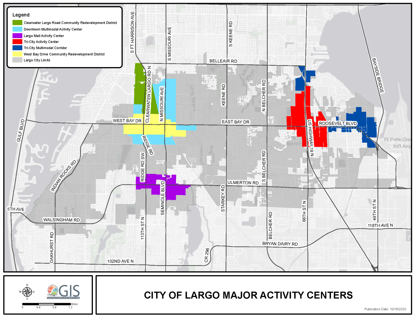
(Ord. No. 2021-32, § 5(Exh. A), 3-2-2021)
7.1.1 - Purpose
The City of Largo Strategic Plan, adopted in 2004 and updated in 2011, recommended that existing commercial nodes be redeveloped into concentrated areas of higher density, mixed-use development which emphasize a multimodal transportation orientation and pedestrian connections to adjacent neighborhoods. This Strategic Plan recommendation is part of a countywide strategy to identify and foster target areas for redevelopment. The City of Largo Comprehensive Plan establishes a framework for implementing this vision through supportive goals and policies, which were used to develop the standards in this section. There are three types of Activity Centers: Major Activity Centers, Neighborhood Activity Centers, and Employment Centers. The three (3) types are described below.
A.
Major Activity Centers
(1)
Location and Description - There are three (3) Major Activity Centers in the City of Largo: The Downtown Multimodal Activity Center (DMAC), the Largo Mall Activity Center and the Largo Tri-City Activity Center (LTAC) (See Map 7-1). Major Activity Centers are characterized by a mix of business, residential and civic uses in a high density, compact physical arrangement that creates a walkable environment, which makes it convenient for residents and employees to travel by public transit, bicycle, foot, or car.
(2)
Regulatory Authority - Development and redevelopment within the Major Activity Centers is guided by Special Area Plans. The Special Area Plans designate allowable uses, development standards, and design standards. The plans also delineate available incentives and provide a framework for public infrastructure improvements within each designated special area boundaries. Dedicated multimodal transportation plans may also be developed for the Major Activity Centers. These plans are coordinated with the Special Area Plan for the area in order to create land use and transportation strategies that are supportive of redevelopment in an urban, pedestrian-oriented form.
B.
Neighborhood Activity Centers
(1)
Location and Description - Neighborhood Activity Centers, while not overlays governed by special area plans and are not regulatory, generally consist of clusters of commercial land uses located at the intersections of arterials and community streets. These areas typically feature commercial uses that serve adjacent neighborhoods.
(2)
Regulatory Authority - Development and redevelopment within the Neighborhood Activity Centers is regulated by the standards applicable to the land uses within each area, as well as by the design guidelines contained within the Urban Design Guidelines for Activity Centers. Development and redevelopment should respect the scale and character of adjacent properties and neighborhoods.
(3)
Design - Bicycle, pedestrian, and public transit connections between Neighborhood Activity Centers and adjacent neighborhoods are encouraged in order to reduce reliance on automobiles. Where parcel sizes permit, residential may also be included. Neighborhood Activity Centers are not expected to result in densities/intensities above what is currently allowed by existing land use designations. However, the change toward a multimodal orientation (better pedestrian and bicycle access, the facilitation of public transit) will result in changes in the physical form of development (buildings will be closer to the street, for instance).
C.
Employment Centers - [Reserved]
(Ord. No. 2021-32, § 4, 3-2-2021; Ord. No. 2025-01, § 11, 12-17-2024)
7.2.1 - Downtown Multimodal Activity Center (DMAC)
A.
General characteristics and purpose - A Multimodal Activity Center is a designated area that incorporates or is anchored by a Major Activity Center or Transit Station Area and is of sufficient scale to support public transit or internal capture of trips within its boundaries. Within Multimodal Activity Centers, emphasis is placed on development that supports the use of multiple forms of transportation, leading to a reduction in automobile use. Designated areas shall be supported by an adopted multimodal capital plan and a CRD Plan, Special Area Plan, Transit Station Area Plan, or Overlay District standards. Multimodal Activity Centers are designated by amending the Comprehensive Plan. The City of Largo has designated one (1) Multimodal Activity Center, which is shown in light blue on Map 7-1 Major Activity Centers in Largo.
The Downtown Multimodal Activity Center (DMAC), encompasses both the Clearwater-Largo Road and West Bay Drive CRD. Both CRDs have adopted Special Area Plans in place. In addition, both were developed through a community-based planning process that directly involved local business owners and residents. The Plans work to cultivate the unique attributes of each district to foster a distinct sense of place and community identity. The Plans also designate allowable land uses, development standards, and design standards to provide a context for future development in the districts. To facilitate implementation of the Plans, specific strategies, including density and intensity bonuses, affordable housing incentives, economic development incentives, and public infrastructure investments, are specified. The strategies leverage public investments and public-private partnerships to achieve pedestrian-oriented, mixed-use development that supports economic and neighborhood revitalization.
B.
Location and boundaries - The Downtown Largo Multimodal Activity Center encompasses the West Bay Drive Community Redevelopment District (WBD-CRD); the Clearwater-Largo Road Community Redevelopment District (CLR-CRD); the Missouri Avenue corridor and adjacent areas between the CRD boundaries to the west and south, Auburn Street to the north, and 4th Street NE to the east; and the area south of 4th Avenue SW, west of Central Park Drive, north of 8th Avenue, and east of the Pinellas Trail, as indicated by Map 7-1.
C.
Transportation Management System - The Transportation Management System refers to the development impacts on transportation facilities and the implementation of mobility improvements pursuant to the Pinellas County Mobility Plan. The Mobility Plan implements multimodal impact fee that is "consumption based" in that new development is assessed based on the value of the increment of a transportation facility needed to serve it. Downtown Districts, which in the case of the City of Largo is the DMAC, receive a reduced rate because generally they produce less vehicle trips due to the concentration and mix of land uses in these areas. These fees shall be used within the district for multimodal improvements based on need. A list of public improvement needs is available in the Downtown Largo Multimodal Plan.
D.
Development standards - Specific development standards for the Downtown Largo Multimodal Activity Center are detailed in Section 7.2.2, Community Redevelopment Districts, below and in this Section.
(1)
Landscape/Pedestrian Improvements - Landscape requirements are intended to recognize the urban nature of the downtown area. Accordingly, the landscape requirements are organized into the following categories:
a.
Streetscaping - Streetscaping involves the creation of a pedestrian friendly environment with adequate sidewalks, well-spaced canopy trees between the street curb and the sidewalk for shade, and low hedges of evergreen shrubs behind the sidewalk to soften building edges and help screen parking lots. Utilities (such as street lights) and street furniture (such as bus shelters, benches and trash cans) are also located in the area between the street curb and the sidewalk in order to separate vehicles from pedestrians and provide a safe, unobstructed walking area. Visibility of the buildings and site from the street is emphasized. Signs, usually monument signs, do not conflict with the higher growing canopy trees. As the trees grow, they can be limbed up, raising the canopy and keeping the building visible. Where outdoor dining is provided, no low growing vegetation at all is needed.
Streetscape in the Mixed Use Corridor (MUC) and Professional Office (PO) Character Districts (CLR-CRD), the MUC and Medical Arts (MA) Character Districts (WBD-CRD) and the Commercial General (CG) and Institutional (I) designated properties in the remainder of the DMAC should receive a treatment suitable to higher density/intensity development and designed to withstand a high volume of pedestrian traffic, while streetscape plantings in the City Home (CH) and Neighborhood Residential (NR) Character Districts (CLR-CRD), the CH and NR Character Districts (WBD-CRD) and residential and all other land use designations in the remainder of the DMAC should reflect the less dense, purely residential nature of the development. Plantings, including street trees, are intended to be consistent in kind and design along each block face. Information on the appropriate types of plant materials, including "Florida Friendly" landscaping, may be found in Chapter 10 of this CDC.
All street frontages in the DMAC are required to have streetscaping as part of the Pedestrian Zone. Streetscaping shall also be provided along the major interior driveways which are intended to provide the primary multimodal access into and through the sites of proposed multi-building developments (see Primary Pedestrian Streets in Activity Center Guidelines, City of Largo, Florida, adopted October 19, 2010). The width and layout of the Pedestrian Zone varies for each Character District and is shown both in tabular and graphic form in the WBD-CRD Plan
b.
Curbside Landscaping/Utilities Area - The area between the back of street curb and the sidewalk in all Character Districts shall minimum of five (5) feet wide and contain:
(i)
Street trees intended to provide an urban tree canopy along each side of the street plus additional low growing landscaping (where appropriate) such as grass or ground cover. Street trees may be planted using a number of treatments, including the use of tree grates and pavers/bricks, or mulch beds with groundcover or grass. Street trees shall be approved canopy trees from the list maintained by the City of Largo Department of Recreation, Parks and Arts. Where overhead utility lines or other special conditions exist, understory trees may be substituted for canopy trees subject to approval by the DCO. Trees shall be spaced according to the landscape standards contained within Activity Centers, Table 7-1.
(ii)
Utilities such as street lights, fire hydrants, parking meters and the conduit serving these utilities; and
(iii)
Street furniture, where applicable, such as bus shelters, benches and trash cans.
Figure 7-1: Streetscaping within the DMAC, above, graphically shows applicable streetscaping
requirements within the MUC, PO, and MA Character Districts
c.
Sidewalk - The sidewalk allows unimpeded pedestrian movement and varies in width from a minimum of five (5) feet wide in the CH and NR Character Districts for both the CLR- and the WBD-CRDs to a maximum of ten (10) feet wide in the MUC and PO Character Districts for the CLR-CRD and in the MUC and MA Character Districts for the WBD-CRD. Within the remainder of the DMAC, the sidewalks are required to be a minimum of five (5) feet wide, with the exception of parcels with Commercial General (CG) and Institutional (I) land uses, which are required to have eight (8) feet wide sidewalks. The sidewalks may be constructed of concrete or pavers and are intended to be consistent in design along each block face. Accordingly, the first project on any block face will determine the design for the remainder of the block face. The sidewalk material shall be chosen not only on the basis of aesthetics but also to minimize maintenance costs.
d.
Areas between sidewalk and building - This area is five (5) feet wide (in the MUC, PO and CH Character Districts for the CLR-CRD and in the MUC, MA and CH Character Districts for WBD-CRD) (it is not required in the remainder of the DMAC) and provides space for additional landscaping to screen surface parking or accent building facades, seating for restaurants and paving for patios. This shall be finished either in paving or landscaping at the option of the property owner. In the NR Character District in both the CLR and WBD CRDs, the Pedestrian Zone ends at the build-to line, where the front yard of residences.
e.
Buffers - Landscaped buffers are required:
(i)
Along a property line shared with a less dense Character District within the CRD;
(ii)
Along a property line shared with a property designated as either Residential Low or Residential Urban Future Land Use Map designation at the perimeter of the CRD; and
(iii)
Around the perimeter of surface parking lots.
Buffers along shared property lines next to less dense development shall be placed in the required perimeter setback (as required in the WBD-CRD Plan for each Character District) and shall be a Type A buffer as defined in Table 10-3 of this CDC. Where a higher density/intensity Character District is separated from a less dense Character District by a public street, landscape buffers are not required; instead, a Pedestrian Zone with streetscaping is required as shown in Figure 7-2. Perimeter buffers for parking lots are required whether they are adjacent to shared property lines or public streets.
Figure 7-2: Streetscaping within the DMAC, above, graphically shows applicable streetscaping
requirements within the CH, NR Character Districts,
as well as residential use and CG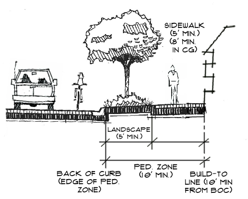
f.
Parking lot landscaping - Perimeter landscaping for surface parking lots will include a minimum five (5) feet wide landscape buffer with canopy trees and a solid three (3) feet minimum height to four (4) feet maximum height wall, fence, linear evergreen hedge, or combination thereof. Interior parking lot landscaping will meet the requirements of Chapter 10 of this CDC.
g.
Sustainable street and parking lot infrastructure - "Green" street infrastructure (landscaped swales in the green space next to the right-of-way to improve water quality and aid in storm water management) are encouraged within the DMAC. The use of green infrastructure is also encouraged to be incorporated into parking lot design through the installation of ribbon curb at the edge of parking lot islands and planting areas, with the plantings installed in swales below the grade of the parking lot to encourage natural drainage and filtration before rainwater enters the conventional stormwater system. Previous parking systems, such as grasscrete, are also encouraged where appropriate. Green infrastructure included in Appendix B., Optional Design Standards (Objective 1.2 Sustainable Downtown: "Use of Alternative Surfaces") of the WBD-CRD Plan and can be used to justify density, intensity and height bonuses.
h.
Optional landscaping - Landscaping may be provided between the back of sidewalk and the front of building, and/or on open space on the property either at the owner's discretion or as part of Optional Design Standards (Appendix B of the adopted WBD-CRD Plan) used to justify bonus height and/or density/intensity.
(2)
Mobility and site connectivity improvements
a.
Sidewalks - Sidewalks will be provided along all street rights-of-way. Where sufficient right-of-way width does not exist to support these improvements, the developer will construct it within an easement approved by and dedicated to the City. Sidewalks shall also be provided along the full length of the primary facade of each building.
b.
Building design - At least one primary entrance shall be visible from the public street and connected to that street by a pedestrian sidewalk aligned with the primary entrance. The primary entrance shall be clearly defined and highly visible. The entrance shall be accentuated with at least three (3) of the following design features:
-
Architectural features such as outdoor patios or plazas;
-
Display Windows;
-
Integral Planters or Wing Walls;
-
Canopies;
-
Arcades;
-
Parapets;
-
Peaked Roofs;
-
Arches; or
-
Architectural details other than those listed above such as details of building design.
c.
Connectivity - Well-defined, safe pedestrian access will be provided between building entrances and public sidewalks, transit stops, parking facilities, external sidewalks, and outparcel buildings. Pedestrian walkways shall be designed in a manner that reduces conflicts between the walkways and vehicular traffic. Public transit facilities shall be provided using landscaped areas, sidewalks, and pavement markings or pavers when crossing vehicular use areas.
Figure 7-3: Pedestrian Connection Example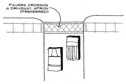
d.
Site design - Building sites shall be designed to promote connectivity to surrounding land uses and streets. Techniques may include development of internal street systems, interconnected driving aisles and shared access, pedestrian access, and siting of buildings in relationship to adjacent development.
(i)
Internal and new streets shall connect to existing streets or be designed to facilitate future connections to the maximum extent possible.
(ii)
Interconnected driving aisles and shared access shall be provided to connect with adjoining sites.
(iii)
Internal street systems shall be required for sites containing multiple buildings
(iv)
Siting of buildings shall take into consideration the relationship of the site to adjacent buildings and internal street systems and driving aisles to promote interconnectivity between adjacent land uses. Separation of buildings by internal streets or driving aisles may be required to promote connectivity and pedestrian orientation.
e.
Bike parking - At a minimum, either Class 1 or Class 2 bicycle parking facilities shall be provided for each project constructed in the MUC, PO Character Districts (CLR-CRD), as well as the MA and CH Character Districts (WBD-CRD). Class 1 bicycle parking facilities shelter the bicycle and its associated components and accessories from theft, vandalism and inclement weather. Examples of Class 1 facilities include bicycle lockers, restricted access parking, guarded parking and valet service. Class 2 bicycle parking refers to short-term storage racks that allows at least one wheel to be secured with a user-provided lock. Racks with two points of contact help prevent bicycles from falling over and are preferred.
(3)
Bonus height, density or intensity - Provision of mobility improvements that address multimodal needs as listed within the Multimodal Vision for Downtown Largo, may be considered to be a public amenity and used to justify bonus height, density and intensity under the Optional Design Standards
Appendix of the WBD-CRD Plan, subject to a Development Agreement with the City.
(4)
Safety and lighting - Site Standards for service areas, security and crime prevention, outdoor lighting and minimum open space requirements are contained within both the CLR-CRD and the WBD-CRD Plans for each Character District.
(5)
Stormwater management - Developments shall comply with all stormwater management requirements in Chapter 11, including the standards in 7.2.1.D(1)g. Sustainable Street and Parking Lot Infrastructure, above.
(6)
Redevelopment Incentives - Two (2) incentive programs have been established to facilitate redevelopment in the Downtown Largo Major Activity Center, they are as follows:
a.
Downtown Multimodal Impact Fee Reductions - Multimodal Impact Fees within the DMAC are reduced by fifty (50) percent as compared to districts outside the DMAC; and
b.
Provision of an alternate development process - Within the DMAC, and the other Activity Centers, a developer and/or property owner may choose the Alternate Development Process. This is an administrative process designed to achieve the City's vision for urban form and mobility standards as provided in the City's Strategic Plan and the "Urban Design Guidelines for Activity Centers," as amended and the CRD Plans for the two CRDs. This process also is administrative and is intended to allow a developer/property owner the ability to propose a project which meets the intent of the City's vision, while allowing for the administrative flexibility to amend certain site layout standards.
(i)
Applications - shall meet all applicable standards of Chapter 3, Level III, Full Scale Review;
(ii)
Review - shall meet the requirements of the Level III, DRC Review contained in Chapter 3. In addition, a review shall be conducted by the staff of the Community Development
Department Urban Design Studio. Applicants are encouraged to participate in collaborative manner with the Urban Design Studio. The Urban Design Studio shall use the principles of the City of Largo Strategic Plan, the guidelines of the "Urban Design Guidelines for Activity Centers" and the mobility standards contained in the Downtown Multimodal Plan as a basis for review;
(iii)
All development plans reviewed under this provision must be approved by the Development Controls Officer (DCO); and
(iv)
Community Development staff shall make a quarterly presentation of all plans approved under this provision to the Community Development Advisory Board (CDAB) at a publicly advertised meeting for the purpose of receiving feedback and guidance on the development of revised principles and guidelines going forward.
(v)
Projects approved under this provision are not required to meet Pinellas County transportation concurrency requirements.
7.2.2 - Community Redevelopment Districts in General
A.
Relationship to state and regional growth management requirements - Chapter 163, Part III, Florida Statutes governs community redevelopment districts (CRDs) and provides a process for their review and approval.
B.
Relationship to countywide land use planning - Both the Clearwater Largo Road Community Redevelopment District (CLR-CRD) and West Bay Drive Community Redevelopment District (WBD-CRD) Plans have been approved under the requirements of the Special Area Plan (SAP) provisions of the Pinellas Countywide Rules. The Countywide Plan and Countywide Rules provide a general land use map and a set of general land use rules common to all the local governments within Pinellas County. Under the Countywide Plan Rules, an SAP is required to designate an area as a Redevelopment District (CRD) on the Countywide Plan Map. Both the Largo City Commission and the Pinellas Board of County Commissioners (acting as the Countywide Planning Authority) must approve a SAP.
C.
Land use designations within the CRDs - In both the CLR-CRD and the WBD-CRD, overlay districts have been created as part of the land use designation of Community Redevelopment District. These are called "Character Districts" and represent areas within the Districts targeted for redevelopment opportunities. In addition, other land use designations found under Section 6.2, exist within the CRDs and represent areas which must be protected and are not currently considered as redevelopment opportunities. Character Districts and other land use designations are shown for each CRD on Map 7-3 Clearwater Largo Road CRD Character District Map, and Map 7-4 West Bay Drive CRD Character District Map.
D.
Relationship to City of Largo land use policy
(1)
Relationship to the Comprehensive Plan - The Comprehensive Plan is the City's growth management tool which identifies the long-range goals that the City wants to achieve over the next fifteen (15) to twenty-five (25) years. The framework of the Comprehensive Plan is regulated by the State of Florida. Every seven (7) years, the City is required to update its Comprehensive Plan by evaluating the status of the goals, objectives, and policies contained in the Plan and identifying new issues of public concern. The Comprehensive Plan is the planning and policy link between the vision and principles of the City of Largo Strategic Plan and the regulatory mechanism of the CDC. The importance of the implementation of both the Clearwater Largo Road and West Bay Drive Community Redevelopment District Plans are specifically reflected in the goals and objectives of the City of Largo Comprehensive Plan, particularly in the Future Land Use Element.
(2)
Relationship to Strategic Plan - The City of Largo Strategic Plan provides a vision for how commercial centers and corridors within the City will redevelop, how the business community will thrive, how infrastructure assets will be maintained, how transportation choices will be expanded, how parks and open space will be cultivated, and how neighborhoods will be preserved. The Strategic Plan is used to align City programming and capital improvements with the community's goals. The redevelopment of the CRDs are incorporated into one of the Strategic Plan's six (6) principles, "create activity centers and mixed use corridors." The Strategic Plan itself is incorporated into the Comprehensive Plan.
(3)
Relationship to adopted mobility plans - The Downtown Largo Multimodal Plan was adopted by the City Commission in 2011. It includes both of the City's downtown CRDs within its boundaries. Consistent with the Comprehensive Plan and the Strategic Plan, the Downtown Largo Multimodal Plan is intended to encourage development and redevelopment of the downtown, creating a community that is walkable and inviting. Implementing the Multimodal Plan for Downtown Largo will provide mobility through options other than the single occupant vehicle. The Multimodal Plan is part of the implementation program for both the Clearwater Largo Road Community Redevelopment District and the West Bay Drive Community Redevelopment District. The boundaries of the Downtown Multimodal Activity Center are shown on Map 7-2.
Map 7-2: CRDs and Multimodal Activity Center Boundaries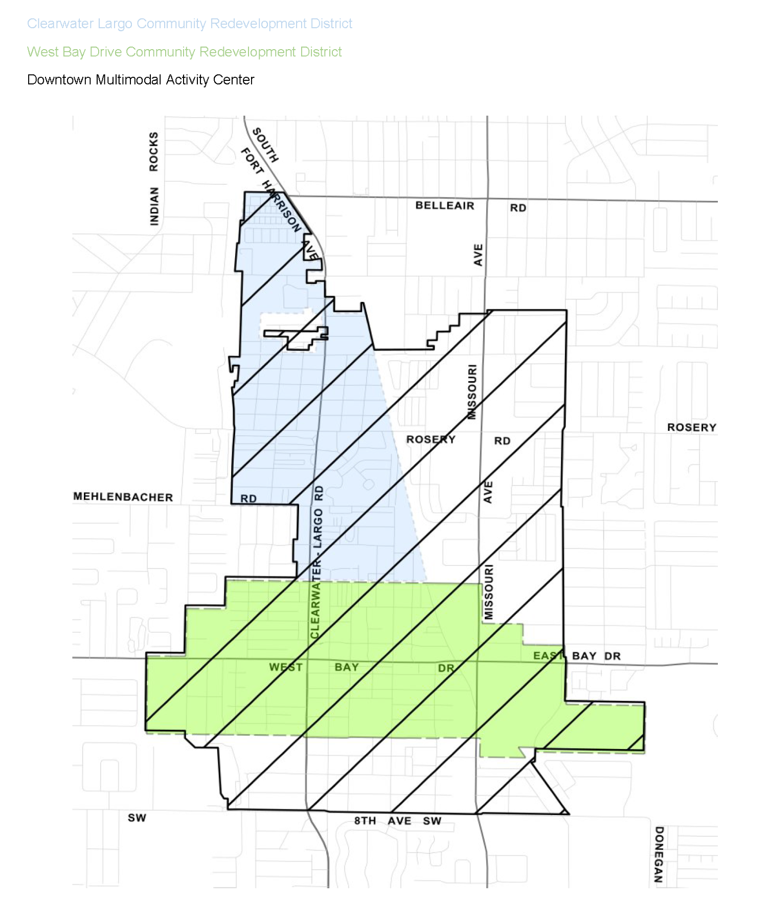
Map 7-3: Clearwater-Largo Road CRD Character District Map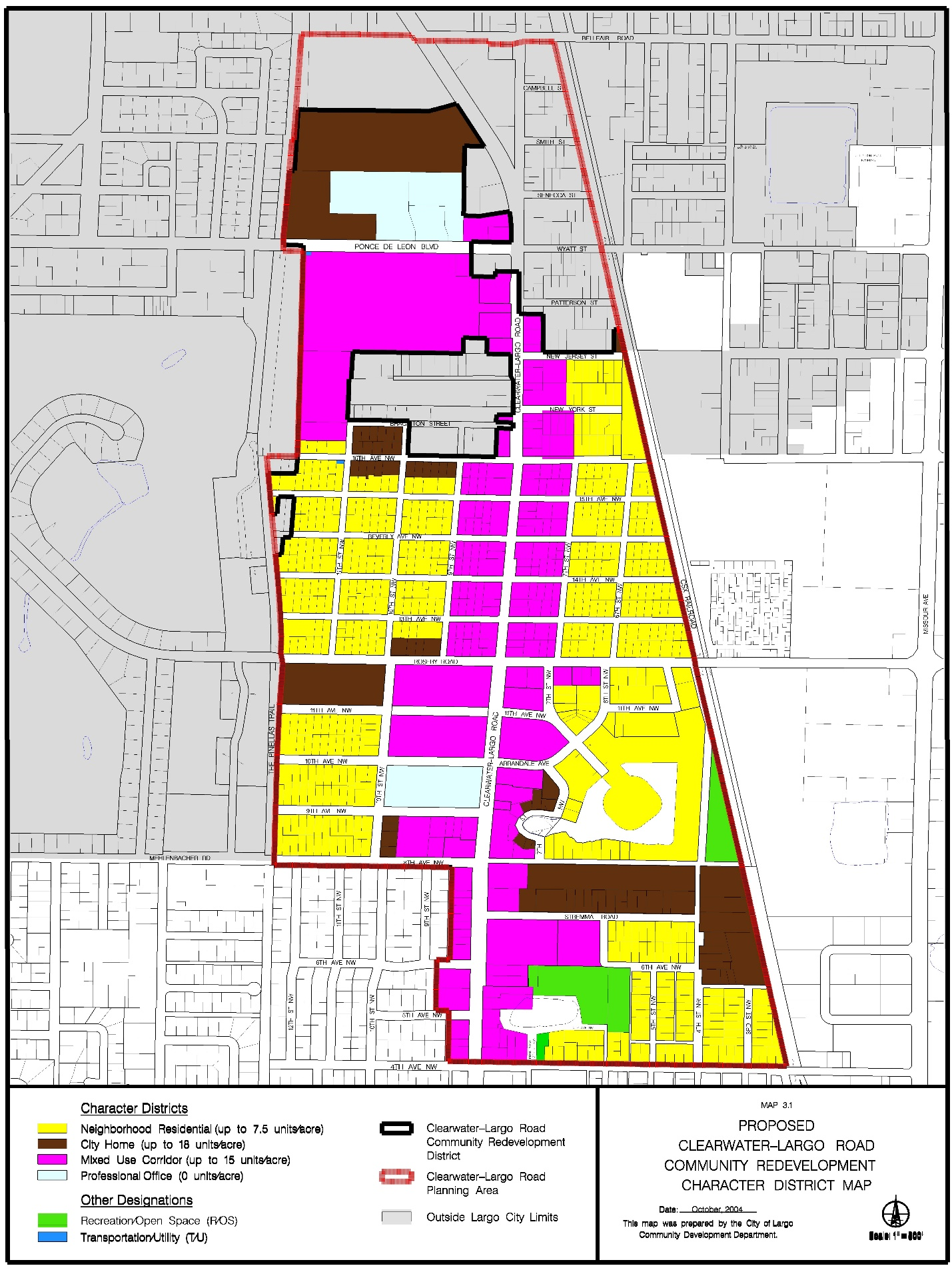
Map 7-4: West Bay Drive CRD Character District Map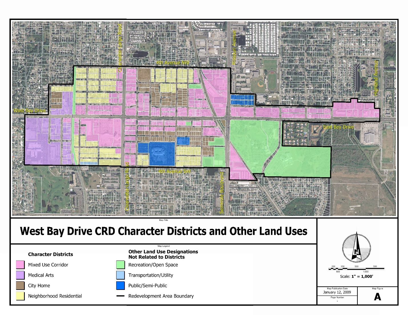
7.2.3 - Clearwater Largo Road Community Redevelopment District (CLR-CRD)
A.
General characteristics
(1)
Objective - To implement the CLR-CRD Plan (as adopted by Ordinance No. 2006-49, as amended by Ordinance No. 2009-05) by creating standards that transform the CLR-CRD into a vibrant mixed use district. The CLR-CRD Plan is intended to serve as the guide for redevelopment of this area for thirty (30) years from the date of adoption.
(2)
Boundaries - The boundaries of the CLR-CRD are provided in Map 7-3.
(3)
Use characteristics
a.
Allowable uses - as contained within Table 6-2 of this Code. Uses not included in either table, which contribute to the intent of the CRD Plan as stated in Section 3.1. Goals, Objectives and Policies, may be approved by the DCO.
b.
Prohibited uses - as contained within Table 6-2 of this CDC. Also, uses which do not contribute to the intent of the CRD Plan as stated in Section 3.1. Goals, Objectives and Policies, may be prohibited subject to a finding by the DCO.
c.
Use restrictions - The following restrictions shall apply to all redevelopment within the CLR-CRD:
(i)
Convenience stores are permitted up to a maximum gross floor area of 2,700 square feet.
(ii)
Gas stations are limited to a maximum of four (4) multi-pump dispensers (MPDs) and twenty-four (24) hoses (associated convenience store maximum of 1,000 square feet of gross floor area).
(iii)
Automotive repair garages engaging in outdoor repairs, or repairs visible from abutting properties or the right-of-way, are prohibited. Included are automotive repair garages which have overnight, outdoor storage of vehicles.
(iv)
Car and boat lots, including retail car sales, using outdoor displays are prohibited.
(v)
Drive-thrus for restaurants are permitted as connections to the site. When a fence is required, shrubs set at three (3) foot on center along the fence, shall also be provided.
(vi)
Live/Work Units, where permitted, must comply with any supplemental standards contained in the CLR-CRD Plan or this CDC. The work component must be an allowable use and shall not exceed 500 square feet per live-work unit.
B.
Character District Descriptions - see Section 5.2.4 J.
C.
Development Standards - The development standards contained in this Section are supplementary to the performance standards contained elsewhere in this CDC. Standards not specifically addressed in this Section shall be governed by the performance standards of the CDC. Where a conflict exists, the provisions of this Section shall govern.
(1)
General Development Standards - Standards for density/intensity, impervious surface ratio (ISR) and minimum lot size for all Character Districts are contained in Table 3.2, Site Design Standards in the CLR-CRD Plan.
(2)
Site Design Standards
a.
Building height - Building height by Character District is contained in Figure 3.3, Building Height in the CLR-CRD Plan.
b.
Building setbacks - Building setbacks are provided in Section 3.7.A.3 Setbacks in the CLR-CRD Plan. In addition, the following shall be required:
(i)
Building Placement - New developments are encouraged to promote a pedestrian-friendly atmosphere by locating the building(s) as close to the sidewalk as possible while complying with all applicable requirements.
(ii)
A maximum setback of seventy (70) feet shall be maintained from the centerline of Clearwater-Largo Road, unless the surrounding buildings are set back at a lesser or greater distance. In such cases, the DCO shall determine the appropriate setback by evaluating the average setback distance of the surrounding structures.
(iii)
When the building is set back seventy (70) feet or more from the centerline of the road, fencing shall not exceed four (4) feet in height along abutting rights-of-way and shall include openings to allow for sidewalk connections to the site. When a fence is required, shrubs set at three (3) foot on center along the fence, shall also be provided.
c.
Parking - Parking requirements are contained in Section 3, District Plan, of the CLR-CRD Plan. Where not specifically provided for in the CRD Plan, the requirements of Chapter 10 of the CDC shall govern. Where a conflict exists, the provisions of the CLR-CRD Plan shall govern.
d.
Mobility Improvements
(i)
The Downtown Largo Multimodal Plan was adopted by Resolution No. 2031. The Plan is part of the implementation program for the CLR-CRD and is intended to provide a functional and attractive environment, supporting both pedestrian and bicycle mobility. Accordingly, sidewalks will be provided along all street rights-of-way. Where sufficient right-of-way width does not exist to support these improvements, the developer will construct them within an easement approved by and dedicated to the City.
(ii)
Well-defined, safe pedestrian access will be provided between building entrances and public sidewalks, public transit stops, and parking facilities.
(iv)
Bicycle parking facilities shall be provided for each project constructed in the MUC, PO and CH Character Districts. This encompasses both Class 1 and Class 2 facilities. Class 1 bicycle parking facilities shelter the bicycle and its associated components and accessories from theft, vandalism and inclement weather. Examples of Class 1 facilities include bicycle lockers, restricted access parking, guarded parking and valet service. Class 2 bicycle parking refers to short-term storage racks that allows at least one (1) wheel to be secured with a user-provided lock. Racks with two (2) points of contact help prevent bicycles from falling over and are preferred.
e.
Stormwater management - Developments shall comply with all stormwater management requirements in Chapter 11, including the standards in Section 7.2.1.D(1)g Sustainable Street and Parking Lot Infrastructure, above.
f.
Signs - Signage shall be built at a pedestrian scale and integrated with the associated building's architectural style. Signage shall comply with the standards of Section 12.11 Signage in the CRDs.
g.
Outdoor Displays of Merchandise - All outdoor displays, whether permanent or temporary, shall not cumulatively exceed twenty-five (25) percent of the gross floor area of the building(s) on the property. Outdoor display of vehicles, automotive supplies, appliances, machinery, and similar products are not allowed. The following restrictions shall apply:
(i)
Permanent outdoor displays of merchandise require site plan approval for the addition floor area. The display area shall comply with the same building setback and landscaping requirements applicable to the primary structure.
(ii)
Temporary outdoor displays of merchandise shall be limited to a representative sample of items sold within the store in a compact and orderly area not to exceed twenty (20) square feet. The display area(s) shall be located near the building entrance(s) and shall be parallel to, and, abutting, either the building facade or the private sidewalk/walkway leading to the entrance(s). Outdoor displays shall be brought indoors when the business is closed. Outdoor displays shall not obstruct parking spaces or handicap accessibility of public or private sidewalks or walkways.
(Ord. No. 2025-01, § 12, 12-17-2024)
7.2.4 - West Bay Drive Community Redevelopment District (WBD-CRD)
A.
General characteristics
(1)
Objective - To implement the West Bay Drive Community Redevelopment District (WBD-CRD) Plan (as adopted by Ordinance No. 2009-31) by creating standards that allow existing businesses, residents and institutions to prosper within the District, while encouraging new investment at urban scale and density in the City's historic downtown. These standards also further the goals of the Strategic Plan and Comprehensive Plan, the Special Area Plan (SAP) provisions of the Pinellas Countywide Rules, and the Downtown Multimodal Activity Center.
(2)
Boundaries - The boundaries of the WBD-CRD are provided above in Figure 8.1 Community Redevelopment Districts (CRDs) and Multimodal Activity Center Boundaries
(3)
Use characteristics
a.
Allowable uses - As contained within Table 6.2 Allowable Uses by Land Use Classification in the CRDs.
b.
Prohibited uses - As listed within each Character District of the WBD-CRD Plan.
c.
Use Restrictions in Character Districts - As listed within each Character District of the WBD- CRD Plan.
(i)
Live/Work Units, where permitted, must comply with any supplemental standards contained in the WBD-CRD Plan or this CDC.
(ii)
Drive-thru restaurants - Drive-thrus for restaurants are permitted as conditional uses, subject to Level III Planning Board approval.
Figure 7-4: Conceptual Pedestrian Zone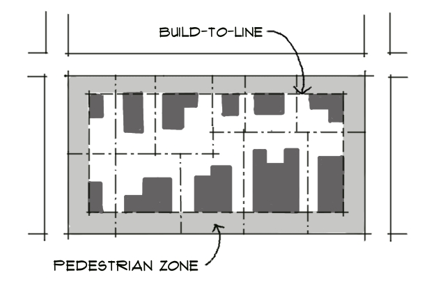
B.
Character Districts - For a description of Character Districts see Chapter 5 of this CDC.
C.
Development standards - The development standards of this Section of the CDC are supplementary to the performance standards contained elsewhere in this CDC. Standards not specifically addressed in this Section shall be governed by the performance standards of the CDC.
Where a conflict exists, the provisions of this Section shall govern.
(1)
General development standards - Standards for density/intensity, height, impervious surface ratio (ISR) and minimum lot size for all Character Districts are contained in Table 2-4: WBD-CRD Development Standards are in the WBD-CRD Plan.
(2)
Site design standards - The following site design standards shall apply to all Level II, Full Scale Review proposals within the WBD-CRD. To the extent practical, Level I, Small Scale Review proposals within the WBD-CRD shall also meet the following standards:
a.
Setbacks/pedestrian zone - In order to create a pedestrian oriented urban environment, building placement is defined by an area around the entire perimeter of a site called the "Pedestrian Zone."
Buildings in the MUC, MA and CH Character Districts are placed at a build-to line, where applicable, immediately behind (or inside of) the Pedestrian Zone. Buildings in the NR Character District are set back behind a front yard in addition to the Pedestrian Zone and placement is further defined by side yard setbacks and rear garages. Figure 7-5 depicts the required front, side and rear setbacks within the MUC Character District.
Figure 7-5: Required Streetscape within the MUC
b.
Building design standards including standards for building height and stepbacks; building placement to create an appropriate transition to adjacent residential neighborhoods; standards to achieve an active ground floor; and standards for architectural design treatments. These standards are provided in the WBD-CRD Plan for each Character District.
c.
Landscaping - Landscaping requirements for the WBD-CRD, including streetscaping, buffers, parking lot landscaping, sustainable street and parking lot infrastructure, and optional landscaping, are contained below in Section 7.2.1.D.
d.
Parking - The WBD-CRD Plan provides "Parking Accommodation" standards for each Character District. Standards not specifically addressed in the WBD-CRD Plan shall be governed by the requirements contained elsewhere in the CDC. Where a conflict exists, the provisions of the WBD-CRD Plan shall govern.
e.
Signs - Sign requirements for the WBD-CRD are contained in Section 12-11.
(Ord. No. 2025-01, § 13, 12-17-2024)
7.2.5 - Largo Mall Activity Center
A.
General characteristics and purpose - The Largo Mall Activity Center (LMAC) is one of three (3) Major Activity Centers identified in the City's Strategic Plan. The LMAC is both a major activity center and an area of regional importance. The objective of the LMAC is intended to provide for a higher quality, including density and intensity, form of development that can serve multiple modes of transportation and promote compact, walkable development. The activity center overlay is intended to provide flexibility within the district to allow development to have higher densities and intensities of up to two (2) times its current allowable dwelling units per acre (du/ac) and floor area ratio (FAR), but not to exceed thirty (30) du/ac or a FAR of 1.1. Table 7-1 provides an outline of the existing and proposed allowable development thresholds per land use within the LMAC. Properties within the LMAC are not required or expected to be developed to the maximum allowable du/ac or FAR as some properties may be restricted due to site location. Properties/projects which provide design and development elements consistent with the Largo Mall Activity Center overlay standards contained within the CDC are entitled to additional density and/or intensity to the thresholds identified by Table 7-1. These standards are intended to enhance the function of new development, minimize community impacts associated with such uses, meet the mobility goals of the Special Area Plan and improve the visual appearance/cohesiveness of all new uses.
B.
Location and boundaries - The LMAC encompasses approximately 325 acres of property that is roughly bisected by Seminole Boulevard and Ulmerton Road, as indicated by Map 7-1.
C.
Streetscape within the LMAC
(1)
Applicability - Streetscape standards apply to all parcels directly abutting public streets within the LMAC.
a.
Area between the back of the street curb and the sidewalk - This area, which is a minimum of five (5) feet in width regardless of adjacent street shall provide space for a minimum of three (3) canopy trees for every one hundred (100) feet of right-of-way. Shrubs and ground cover are not required.
b.
Sidewalk width - Sidewalk widths vary between five (5) feet in width minimum along collector, local and internal streets and eight (8) feet along arterial streets.
c.
Area between the sidewalk and building - This area, which is a minimum of five (5) feet in width, provides space for additional landscaping to screen surface parking or accent building facades, seating for restaurants and paving for patios. This area shall be finished either in paving or landscaping at the option of the property owner.
d.
Sustainable street infrastructure - "Green" street infrastructure (landscaped swales in the green space next to the right-of-way to improve water quality and aid in storm water management) is encouraged. Green infrastructure is included in Appendix B., Optional Design Standards (Objective 1.2 Sustainable Downtown: "Use of Alternative Surfaces") of the WBD-CRD Plan. The provision of these measure can be used to justify density, intensity and height bonuses. The DCO may reduce required streetside landscaping (including width of buffer and amount of trees and vegetation required) in return for the installation of bioswales or other green infrastructure adjacent to the street curb as part of the streetscape.
(2)
Internal street network requirements
a.
Applicability - Major interior driveways providing access to the entire site shall be designed as primary pedestrian streets (See Figure 7-6).
b.
Pedestrian streets through parking lots - Diagonal or straight-in parking is not allowed within the primary ingress/egress drive of the primary pedestrian street. Parallel parking is allowed (See Figure 7-8).
c.
Design elements - Primary pedestrian streets shall have a sidewalk on both sides that is a minimum of five (5) feet in width and streetscaping consisting of a minimum five (5) foot wide continuous landscape strip between the street or vehicle way curb and the sidewalk. Streetscaping in this landscape strip shall consist of canopy trees and evergreen ground cover. See Table 7-2.
1
Quantities are given for every one hundred (100) feet of right-of-way. Where parking, loading or internal driveways directly about the street right-of-way and/or an internal Primary Pedestrian Street, a Type A Landscape Buffer will be required in addition to the streetscape requirements.
2
Where overhead utilities exist, understory trees may be planted as a substitute for the canopy tree requirement at a ratio of two (2) understory trees for each canopy tree. There would thus be a total of six (6) understory trees required for each one hundred (100) lineal feet of right-of-way.
3
Shrubs are to be low growing, evergreen shrubs. Alternately, a sufficient quantity of evergreen ground cover to cover an area 5 feet wide × 100 feet long (500 square feet) for each one hundred (100) lineal feet of right-of-way may be planted.
D.
Off-street parking design in activity centers
(1)
Parking sub-groups - All parking lots shall be divided into clearly defined groupings of spaces with no more than fifty (50) spaces in a group. Such groups shall be broken into individual areas and/or separated by landscaping and/or by design components of the site or buildings.
(2)
Loading and storage areas - The site plan must demonstrate that loading and storage areas are carefully screened from view by pedestrians, motorists and nearby residents and businesses.
(3)
Dumpsters - All dumpsters must have solid panels that screens the area from the view of pedestrians, motorists and nearby residents and businesses. See Figure 7-7.
Figure 7-6: Example of an Internal Street Network
(4)
Utility equipment - Mechanical equipment or other utility hardware on roofs, ground, or buildings shall be screened from public view with architectural and/or landscape materials consistent with the building, or they shall be located so as not to be visible from any public ways. See Figure 7-9.
(5)
Sustainable Parking Lot Infrastructure - The provision of green infrastructure can be used to justify density, intensity and height bonuses. The DCO may reduce required streetside buffer landscaping (including width of buffer and amount of trees and vegetation required) as well as number of required parking spaces, in return for the installation of bioswales or other green infrastructure adjacent to the street curb as part of the streetscape. Green infrastructure is included in Appendix B., Optional Design Standards (Objective 1.2 Sustainable Downtown - "Use of Alternative Surfaces") of the WBD-CRD Plan.
Figure 7-7: Dumpster Enclosure
Figure 7-8: Internal Street Standard Within the Largo Mall Activity Center
Figure 7-9: Utility Screening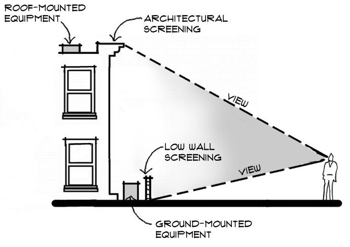
(Ord. No. 2025-08, §§ 19, 20, 6-17-2025)
7.2.6 - Largo Tri-City Activity Center
A.
General characteristics and purpose - The Largo Tri-City Activity Center (LTAC) is a Major Activity Center identified in the City's Strategic Plan. The LTAC is both a Major Activity Center and an area of regional importance included in the Pinellas County Gateway/Mid-County Master Plan. The objective of the LTAC is intended to encourage redevelopment and infill development with a mix of higher density and intensity uses and transit-oriented design that supports increased walkability and transit usage. The activity center overlays are intended to allow development to have higher densities and intensities and require additional design standards to support the vision for the activity center. These standards are intended to:
(1)
Enhance the function of new development, minimize community impacts associated with such uses;
(2)
Meet the mobility goals of the Special Area Plan; and
(3)
Improve the visual appearance/cohesiveness of all new uses.
To appropriately scale development density and intensity from the transit node at the intersection of U.S. Highway 19 and Roosevelt Boulevard out to the boundaries of the activity center two separate overlays were created: Transit Core Scale and Urban Scale. Table 7-3 provides an outline of the allowable development thresholds in each of the two activity center overlays within the LTAC. The LTAC overlays do not change the allowable use entitlements of any of the future land use designations codified in Chapter 6, Table 6-1: Allowable Uses within Land Use Classifications. Properties/projects which provide workforce/affordable housing and/or sustainable development in accordance with subsection 7.2.6.C consistent with the Largo Tri-City Special Area Plan (SAP) are entitled to additional density and/or intensity to the thresholds identified by Table 7-3.
B.
Location and boundaries - The LTAC overlays encompass approximately 379 acres (159 acres in the Transit Core overlay and 220 acres in the Urban Scale overlay) that are roughly centered around the intersection of U.S. Highway 19 and East Bay Drive/Roosevelt Boulevard, as indicated by Map 7-1.
C.
Density and intensity - Table 7-3: Largo Tri-City Special Area Plan Overlays Density and Intensity
(1)
Base Maximum Density and Intensity - The Largo Tri-City Overlays shall allow higher densities and intensities than are permitted in the underlying future land use designations. These allowable densities and intensities are shown in Table 7-3. However, properties classified as Commercial General (CG), Commercial Recreation (CR), and Residential High (RH) are permitted to use the base density afforded to them through their Future Land Use Map classification. The Major Activity Center Transit Core Scale Overlay shall allow a maximum base density of 30 units per acre and intensity of 2.0 floor area ratio. The Major Activity Center Urban Scale Overlay shall allow a maximum base density of 25 units per acre and intensity of 1.5 floor area ratio. The Multimodal Corridor Overlay shall allow a maximum base density of 20 units per acre and intensity of 1.0 floor area ratio.
(2)
Bonus Maximum Density and Intensity - Density and intensity bonuses, as shown in Table 7-3, may be achieved with the following elements incorporated into any individual development order to accomplish the Special Area Plan priorities such as promoting affordable and workforce housing, sustainable development and enhanced open/civic spaces:
a.
Affordable Housing Bonus Option 1 - Affordable housing may receive up to 20 dwelling units per acre of additional density (above the base residential density) by providing dwelling units for households with incomes at or below 80 percent of the area median income (AMI). This bonus shall comply with Sections 14.1.3.D and 14.1.4.B of the CDC and is based on the following scale:
(i)
Minimum 20% of Total Units meets one of the following:
1.
60—80% AMI + 10 Units/Acre
2.
< 60% AMI + 15 Units/Acre
(ii)
Minimum 40% of Total Units meets one of the following:
1.
60—80% AMI + 15 Units/Acre
2.
< 60% AMI + 20 Units/Acre
b.
Affordable Housing Bonus Option 2 - Alternatively, affordable housing may receive up to 10 dwelling units per acre of additional density (above the base residential density) by providing dwelling units for households with incomes between 80—120 percent of the area median income (AMI). This bonus shall comply with Sections 14.1.3.D and 14.1.4.B of the CDC and is based on the following scale:
(i)
Minimum 20% of Total Units meets the following:
1.
80—120% AMI + 5 Units/Acre
(ii)
Minimum 40% of Total Units meets the following:
1.
80—120% AMI + 10 Units/Acre
c.
Green Building Bonus Option - Developments meeting the following Leadership in Energy Efficient Design (LEED) or National Green Building Standard (NGBS) certification criteria may receive an increase of 0.5 FAR and/or 10 dwelling units per acre subject to the following scale and requirements:
(i)
Density and Intensity Bonus Scale:
1.
LEED or NGBS Platinum certification qualifies for an additional 0.5 FAR and/or 10 units per acre.
2.
LEED or NGBS Gold certification qualifies for an additional 0.25 FAR and/or 5 units per acre.
3.
LEED or NGBS Silver certification qualifies for an additional 2.5 units per acre.
(ii)
Requirements:
1.
Documentation - Applicant shall provide proof of registration of the project with the LEED or NGBS, proof of payment of all applicable fees for the rating system, a draft scorecard showing the achieved credits or points or any third-party documentation from an appropriately credentialed green building professional demonstrating how the measure is equivalent to the indicated certification level.
2.
Green Building Density Bonus Agreement - For properties receiving an intensity/density bonus pursuant to the Green Building Bonus Option, a land use restriction agreement must be entered into to ensure compliance with the requirements of this section of the CDC, prior to issuance of building permits. The land use restriction agreement will be recorded in the official records of Pinellas County, and will subject the property to covenants and restrictions running with the land for a minimum of thirty (30) years. The land use restriction agreement shall be in a form acceptable to the City Attorney.
3.
A certificate of occupancy for any building utilizing bonuses will not be issued until all incentive options are verified by documentation, as deemed necessary by the Development Controls Officer, and field inspections.
4.
If the owner cannot achieve the incentives provided in the land use restriction agreement, the owner shall be required to substitute incentive options to earn all points necessary for the Green Building Bonus Option, which must be approved by the Development Controls Officer, before a certificate of occupancy will be issued.
d.
Sustainable Development Bonus Option - [Reserved]
(3)
Floor Area Ratio Exemption - The following are not included in the calculation of floor areas and/or are exempt from FAR limitations:
•
Civic and open space, including interior atriums, outdoor plazas, courtyards and seating areas, or other public pedestrian use areas.
(4)
Density and Intensity Restrictions - The density and intensity allowed by the overlays does not apply to properties with a future land use designation of Preservation (P) or Recreation/Open Space (R/OS) or that are located within a Coastal High Hazard Area (CHHA).
D.
Development standards - Development standards apply to all parcels within the LTAC overlays in addition to all other applicable CDC standards, including but not limited to minimum lot sizes, impervious surface ratios and landscaping. Where there is a conflict between the standards of this section and other development standards in this CDC, the standards of this section shall govern.
(1)
Building Form and Placement:
a.
Minimum Street Frontage Setbacks:
(i)
East Bay Drive/Roosevelt Blvd. and U.S. 19 Frontage Road: 15 feet.
(ii)
All other roads: 0 feet.
b.
Maximum Building Height per Table 7-4: Largo Tri-City Maximum Building Height.
c.
Compatibility with Adjacent Uses:
(i)
Building height stepbacks - Buildings exceeding 3-stories adjacent to property with existing single family home uses or property with a very low density (up to 1 unit per acre) or low density (2.5 to 7.5 units per acre) residential FLUM designation shall have a building stepback to minimize impacts on adjacent properties. The building stepback shall measure a minimum of ten (10) feet deep from the lower story building facade commencing above the third story to increase light and air movement and mitigate the effect of the increased height on the adjacent properties. At the discretion of the DCO, if setbacks are proposed beyond the minimum required, stepbacks may be waived. See Figure 7-10.
(ii)
Additional setback requirements - Buildings exceeding 2-stories adjacent to property with a very low density residential FLUM designation (up to 1 unit per acre) shall have a fifty (50) foot setback in addition to the minimum required buffer for every story above the second story. For example: a 4-story building shall have a setback of at least one hundred (100) feet in addition to the minimum required buffer from adjacent property with a very low density residential FLUM designation. Buildings exceeding 2-stories adjacent to property with existing single family home uses or property with a low density residential FLUM designation (2.5 to 7.5 units per acre) shall have a twenty (20) foot setback in addition to the minimum required buffer for every story above the second story. For example: a 4 story building shall have a setback of at least forty (40) feet in addition to the minimum required buffer from adjacent property with existing single family home uses or property with a low density residential FLUM designation. See Figure 7-10.
Figure 7-10: Building Height Stepbacks & Additional Setbacks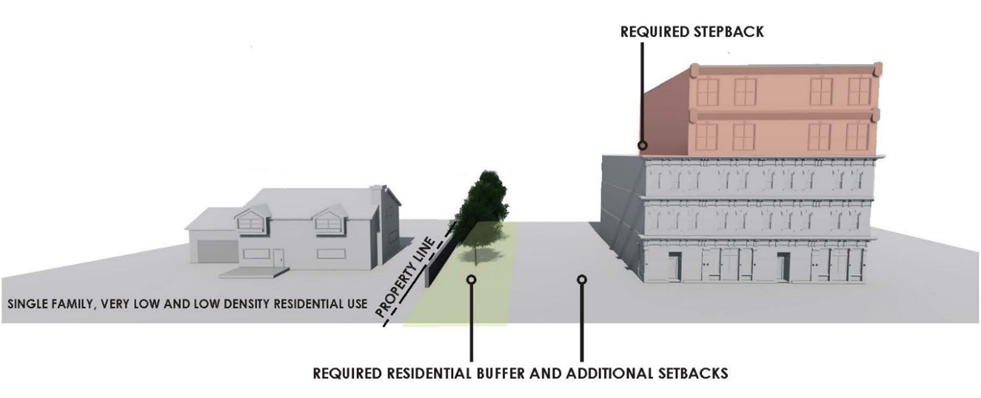
d.
Design Elements:
(i)
A façade transition line shall be provided at the top of the second story. The transition will be expressed by a material change, a trim line, or a balcony.
(ii)
Ground floors are required to have an active use with building entrances that face the pedestrian realm.
(iii)
All buildings should have their primary pedestrian entrance oriented towards the street.
(iv)
For office and retail uses, the ground floor elevation shall achieve a minimum of 60% transparency. Upper floors (high than 20 feet above grade) shall be no greater than 35% transparent.
(v)
Buildings adjacent to East Bay Drive/Roosevelt Boulevard and U.S. 19 frontage roads shall address multiple frontages and orientations.
(vi)
Structures facing East Bay Drive/Roosevelt Boulevard and U.S. 19 frontage roads may have one bay of parking in front of the building, while structures facing all other roads shall have pedestrian-oriented building design.
(vii)
Predominant exterior building materials shall be composed of high quality materials, such as architectural block, brick, concrete with an architectural finish, stucco, or glass. Exterior building materials shall not include unfinished concrete panels, pre-fabricated metal panels or smooth face concrete block.
(viii)
There shall be no expanse of blank walls greater than 20 feet. When architectural features are not an option, landscaping or murals may be allowed as an alternative.
e.
Architectural Design Review Submittal Requirements - Developers shall provide architectural elevations with sufficient detail to demonstrate the project meets the requirements of Largo Tri-City Activity Center at the time of preliminary site plan review.
(2)
Public Realm and Connectivity:
a.
Sidewalks - New development and redevelopment shall construct, reconstruct or expand frontage road sidewalks to the following minimum widths:
(i)
Activity Center Transit Scale Overlay Minimum Sidewalk Width:
•
East Bay Drive/Roosevelt Blvd. and U.S. 19 Frontage Road: 10 feet.
•
All other roads: 8 feet.
(ii)
Activity Center Urban Scale Overlay Minimum Sidewalk Width:
•
East Bay Drive/Roosevelt Blvd. and U.S. 19 Frontage Road: 8 feet.
•
All other roads: 6 feet.
b.
Internal private roads shall have sidewalks serving internal circulation.
c.
Other Pedestrian Walkways:
(i)
Pedestrian walkways shall be provided to access parking behind or to the side of buildings, connect destinations on adjacent properties, connect building frontages to adjacent sidewalks, and allow pedestrian circulation through parking lots to create a continuous pedestrian network.
(ii)
Pedestrian walkways shall be provided along individual or shared driveways connecting rights-of-way with side and rear yard parking.
(iii)
Pedestrian walkways shall be 6-foot wide minimum and free of obstructions.
(iv)
Pedestrian walkways that cross a parking area, driveway, street or other vehicular use area shall be clearly marked with striping, contrasting paving materials (e.g., light-color concrete inlay between asphalt), textured or raised pavement, or other appropriate treatment as approved by the DCO.
d.
Transit Facilities - The applicant for a development approval is responsible for coordinating with PSTA and the appropriate jurisdiction for the roadway on which development is proposed, to identify locations within and bordering the project boundary where current or planned transit stops are or will likely be located. At those locations, space shall be reserved for transit shelters and any required associated improvements, including bicycle racks.
e.
Access and Circulation:
(i)
Access and Driveway Consolidation - Curb cuts and driveways shall be consolidated where possible and located to minimize impact on pedestrian circulation along public sidewalks and front building facades.
(ii)
Cross Parcel Connections and Shared Access - To facilitate circulation and improve accessibility, vehicle and pedestrian networks on adjacent sites shall be interconnected and cross-access easements implemented. Parking lot drive aisles and pedestrian walkways shall be aligned and connected and drive aisle stub outs shall be constructed on properties abutting undeveloped sites to allow for future connections.
(iii)
Connection to Duke Energy Trail - Connections to the Duke Energy Trail shall be incorporated into site plans where property is adjacent to the Trail when feasible.
(iv)
Connective street network - Where feasible, new street network connections shall be incorporated into development sites and dead-end street and culs-de-sac shall be minimized.
f.
Reconstruction of Sidewalks and Landscaping - Reconstruction of existing sidewalks and landscape within rights-of-way shall be required. To the extent possible given right-of-way limits and utility conflicts, and with approval of the FDOT, Pinellas County, and/or the City, reconstruction shall follow the general standards for landscaping and sidewalks within the CDC and City Engineering Standards.
g.
Trash collection, mechanical equipment and loading areas:
(i)
Areas for trash collection and compaction, truck parking, loading docks, utility and other service functions shall be incorporated into the overall design of the building using decorative and durable materials consistent with the building facades.
(ii)
All containers for trash collection and compaction are required to be screened from the right-of-way and all adjacent properties. Enclosures shall be a minimum of six (6) feet in height and constructed of solid masonry walls with solid gates that totally conceal all of the contents. Where possible, they should be located behind buildings, away from streets, and obscured from public view from driveways.
(iii)
Additional landscape plantings shall be provided adjacent to truck parking, loading docks, utility and other service functions that are visible from the public right-of-way to further enhance the appearance.
(3)
Parking Regulation and Requirements - Parking shall be provided for within the LTAC consistent with Chapter 9 of the CDC and the following standards. Where there is a conflict, the standards of this section shall govern.
a.
Parking shall be placed at the rear of buildings or hidden/buffered from public right-of-way, internal private streets and open/civic spaces.
b.
Surface parking lots shall be screened with landscaping or a decorative façade structure to create an attractive public realm. Surface parking lots shall comply with the following standards:
(i)
Surface parking located along public sidewalks shall be screened from view by a low (24 to 36 inches) opaque hedge or wall.
(ii)
Alternative: Any surface parking areas fronting a street right-of-way that exceeds fifty percent (50%) of the property street frontage length shall provide a minimum five (5) feet wide landscape buffer with canopy trees and a solid three (3) feet minimum height to four (4) feet maximum height wall, decorative fence, linear evergreen hedge, or combination thereof.
c.
One bay of parking with no more than two rows of parking stalls permitted between buildings and the right-of-way along East Bay Drive/Roosevelt Boulevard and U.S. 19 Frontage Roads.
d.
On-street parking within 500 feet of the development site may be used towards meeting parking requirements.
e.
Parking in excess of maximums shall be permitted if the excess parking is shared within a 1,500 ft radius.
f.
Reduction of required minimum parking spaces by ten percent (10%) shall be permitted for development within ¼ mile of a public transit stop.
g.
Parking in excess of 90% of the maximum allowed, shall utilize reinforced grass or other permeable surface. All driveways and/or access aisles shall be improved with a permanent all-weather paving material which is graded to drain stormwater.
h.
Interior islands of parking lots in new projects shall be designed to utilize Low Impact Development techniques such as bioretention swales and native species. Where parking curbs and gutters are provided, they shall have breaks to allow water to enter the bioretention facilities within the parking landscape islands.
i.
Parking structures along street frontages shall incorporate liner buildings, active ground floor uses, or articulation of the façade (with design and materials compatible to adjacent buildings) to create a pedestrian friendly street edge.
j.
Reserved.
(4)
Open and Civic Space Requirements - The objective of this section is to ensure the provision of well-designed open and civic spaces to enhance the attractiveness, livability, and economic vitality of new development and redevelopment consistent with the Largo Tri-City Special Area Plan and the Activity Center Design Guidelines.
a.
Required area - Development projects greater than 4 acres in area, except for industrial uses or development within the Industrial Limited future land use designation, shall set aside a minimum of 5% of the total acreage of the proposed project as open and civic space.
b.
Area restrictions - The following areas may not be used in the open and civic space calculations: landscaping that is required for buffers, parking areas or screening of mechanical equipment, loading zones or other similar areas; medians; parking areas; private yards for single family developments, courtyards, or fenced areas only accessible by non-residential building occupants; and areas used for stormwater management or drainage system that are not accessible and enhanced as an open and civic space amenity. Enhanced stormwater systems must include at a minimum a hardscaped seating area and perimeter walkways. Enhanced stormwater systems larger than 3,600 square feet must also include a shade structure, water fountain, pedestrian scaled lighting, and a pet waste station.
c.
Location and use - Open and civic spaces should be visible and accessible from adjacent streets, sidewalks and buildings. Open and civic spaces should be incorporated in the development and designed for access by the general public during normal hours of operation of the principal use.
d.
Form - Open and civic spaces should generally be square or rectangular in form and located at the corner or end of a development block or surrounded on all sides by streets as long as traffic does not impede pedestrian access to and from the space. To ensure access, comfort, and adaptability, open and civic spaces are to be designed as extensions of the streetscape environment and include adequate seating, shade, landscaping, and open spaces for informal gathering and planned events. Clear lines of site are required to allow for the formal and informal surveillance of the space. The grade of hardscape areas, lawn panels, and planting beds shall generally match adjacent sidewalks.
e.
Open and Civic Space Types - Open and civic spaces should be designed as either a central space, neighborhood space, pedestrian activity zone or a combination of central or neighborhood space and pedestrian activity zone. See Figure 7-11.
(i)
Central spaces are required for development projects that are ten or more acres in area. Central spaces should be centrally-located within the project, and to be located in clear sight of key intersections. Designs elements will include hardscape area with seating, lighting, shade structures, and amenities designed to support active use and allow for the possibility of special events and activities.
(ii)
Neighborhood spaces are required for development projects that are between four and ten acres in area. Designs will include a mix of hardscape and landscape areas with seating and other amenities designed to support passive uses and limited allow for the possibility of small-scale active uses.
(iii)
Pedestrian Activity Zones - Pedestrian activity zones allow for attractive sidewalks, outdoor activities, display or dining, seating, public art and other amenities. Non-residential and mixed use buildings should include pedestrian activity zones between the building and parking lot, drive aisles, and internal streets.
(iv)
The minimum width for pedestrian activity zones is 15 feet and must include a pedestrian clear zone width of at least five feet.
f.
Amenity Requirements:
•
Placement. Furnishings must be placed at least forty-two (42) inches from the curb. Furnishings may not be placed within the pedestrian clear zone.
•
Minimum Seating and Trash Receptacles. A minimum of one trash receptacle and one seating area is required for each building frontage and for each 5,000 square feet of open and civic space.
•
Seating Requirements. Acceptable seating options include, but are not limited to benches, moveable seats, low walls, ledges, and steps. Each seating area must provide seats for at least four (4) people and meet the following minimum design standards: seating materials must be durable, weather resistant and free of any sharp edges. With the exception of individual moveable chairs, seating must be permanently anchored and immovable.
•
Seating Height and Depth. Seating surfaces shall be between 16 and 18 inches high. Seating without a back must be at least 16 inches deep. Seats with a back shall be no less than 14 inches deep.
•
Wall, Ledge, and Step Seating. Walls, ledges, and steps to be used for seating must be between 12 and 20 inches high, and at least 16 inches wide. Walls designed for seating on both sides must be at least 30 inches wide.
•
Landscaping. Three canopy trees are required within the pedestrian activity zone for each 100 lineal feet of building frontage and for each 5,000 square feet of central or neighborhood space. Understory trees may be used in place of canopy trees at a minimum rate of 2.5 to 1.
g.
Weather Protection - To enhance the pedestrian experience and architecture, buildings are required to provide protection from rain and sun. At a minimum, building facades must include weather protection along at least 75% of façade lengths fronting open and civic space. Where required, weather protection may be provided through the use of arcades, galleries, canopies, or awnings that generally meet the Activity Center Urban Design Guidelines.
h.
Lighting:
•
Pole mounted light heights may not exceed 15 feet within pedestrian activity zones or public spaces; 30 feet in driveways, or 25 feet in parking areas.
•
Light fixtures may not be placed within a pedestrian clear zone.
•
All intersections, parking areas, and perimeter public roads shall be illuminated with similar poles and fixtures.
Figure 7-11: Civic & Open Space Type Examples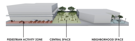
(5)
Auto-oriented and other special use restrictions:
a.
Drive-thrus, Gas Stations and Self-Storage Facilities subject to Supplemental Standards in Chapter 15.
b.
Prohibited Outdoor Uses -
(i)
Vehicular repair garages engaging in outdoor repairs or repairs visible from abutting properties or the right-of-way.
(ii)
Vehicular repair garages which have overnight, outdoor storage of vehicles.
c.
Residential development in the Residential/Office General (R/OG) and Residential/Office Limited (R/OL) future land use designations shall be limited to an area no greater than 5 acres consistent with Countywide Plan Rules, Section 2.3.3.6 - Office category.
(6)
Other Applicable Standards:
a.
Activity Center Design Guidelines - All non-industrial uses shall be designed generally in accordance with the Activity Center Guidelines (Resolution No. 2026, as amended from time to time).
b.
Large Scale Retail Development Standards - Commercial developments that meet the criteria for large scale retail development in Section 13.1 of the CDC shall comply with the requirements set forth in Chapter 14 of the CDC in addition to the requirements of this section.
(Ord. No. 2021-32, § 6, 3-2-2021; Ord. No. 2022-02, § 2, 3-15-2022; Ord. No. 2023-27, §§ 2, 3, 6-20-2023; Ord. No. 2023-52, § 2, 10-17-2023; Ord. No. 2024-18, §§ 2, 3, 3-5-2024; Ord. No. 2025-08, § 21, 6-17-2025)
7.3.1 - Neighborhood Activity Centers
A.
Location - The Neighborhood Activity Centers are generally located at the intersections of arterials and community streets and encompass all sites within a one-half (½) mile radius of each intersection.
B.
Development standards - The land uses generally found within Neighborhood Activity Centers include: Commercial General, Commercial Neighborhood, Residential Office General, Residential Office Retail, Residential Office Low, Industrial Limited, Industrial General, and Institutional. Development and redevelopment within the Neighborhood Activity Centers is regulated by the standards applicable to these land use designations, and the Urban Design Guidelines for Activity Centers.
7.3.2 - Employment Centers
[Reserved]
7.4.1 - Purpose
Corridors are defined as the land uses that are generally adjacent to significant roadways in the City and support the modes of transportation intended for those roadways. Within the City, there are three (3) types of corridors: Mixed-Use Corridors, Community Streets, and Scenic Non-Commercial Corridors; and a Multimodal Corridor Overlay. These corridor types are described below.
(Ord. No. 2021-32, § 7, 3-2-2021)
7.4.2 - Mixed-Use Corridors
A.
Location - The Strategic Plan identifies East/West Bay Drive, Roosevelt Boulevard, Ulmerton/Walsingham Road, Missouri/Seminole Boulevard, and 66th Street as sprawling strip commercial corridors that should be redeveloped into mixed-use corridors over time. Development along these corridors should contain a mixture of complimentary/supportive uses, such as a combination of residential, office, and commercial uses. These uses should support all modes of transportation (automobile, bicycling, walking, and mass transit).
B.
Development standards - The land uses generally found along the Mixed-Use Corridors include: Residential Urban, Residential Medium, Commercial General, Commercial Neighborhood, Residential Office General, Residential Office Retail, Residential Office Low, Industrial Limited, Industrial General, and Institutional. Development and redevelopment along Mixed-Use Corridors is regulated by the standards applicable to those land use designations. In addition, within the right-of-way of each Mixed-Use Corridor, streetscape standards of Section 7.2.1.D.(1) a. above, shall be instituted as part of the redevelopment of the sites.
C.
Incentives - [Reserved]
7.4.3 - Community Streets
A.
Purpose - The City's Community Streets form a local interconnecting street network that provides safe and attractive connections between neighborhoods, parks, community facilities, and daily commercial services. Context sensitive design is used to design these roadways to respect existing land uses along the roadways and balance options for residents of the City, as well as help reduce the number of bicycle and pedestrian accidents that occur along these streets. See Map 7-5, Community Streets.
Map 7-5: Community Streets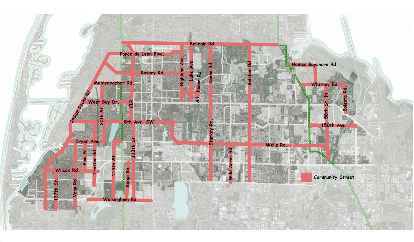
B.
Incentives - [Reserved]
(Ord. No. 2025-08, § 22, 6-17-2025)
7.4.4 - Scenic Non-Commercial Corridors
A.
Intent and purpose - The intent and purpose of the Scenic Non-Commercial Corridor designation is to guide the preservation and enhancement of scenic qualities, to ensure the integrity of the Countywide Plan Map, and to maintain and enhance the traffic operation of these especially significant roadway corridors in Pinellas County. The principal objectives of Scenic Non-Commercial Corridor designations are:
(1)
To preserve and enhance scenic qualities found along these corridors and to foster community awareness of the scenic nature of these corridors;
(2)
To encourage superior community design and enhanced landscape treatment, both outside of and within the public right-of-way;
(3)
To encourage land uses along these corridors which contribute to an integrated, well planned, and visually pleasing development pattern, while discouraging the proliferation of commercial, office, industrial, or intense residential development beyond areas specifically designated for such uses on the Countywide Plan Map;
(4)
To assist in maintaining the traffic operation of roadways within these corridors through land use type and density/intensity controls, and by conformance to access management regulations, by selective transit route location, and by the development of integrated and safe pedestrian and bicycle systems; and
(5)
To encourage design standards identified within the Pinellas Countywide Scenic Non-Commercial Corridor Master Plan, through the adoption of local ordinances and regulations consistent with those standards set forth within the Master Plan.
B.
Applicability - Countywide rules for land use changes along Scenic Non-Commercial Corridors shall be applied to those corridors identified on the Countywide Plan Map.
C.
Countywide Rules - When an application is made to amend the Countywide Plan Map on a Scenic Non-Commercial Corridor, the Forward Pinellas Board and the Countywide Planning Authority review the application according to provisions within the Countywide Rules.
(Ord. No. 2025-08, §§ 23, 24, 6-17-2025)
7.4.5 - Largo Tri-City Multimodal Corridor Overlay
A.
General characteristics and purpose - The objective of the Multimodal Corridor Overlay is intended to encourage redevelopment and infill development with a mix of higher density and intensity uses and transit-oriented design that supports increased walkability and transit usage. The overlay shall allow development to have higher densities and intensities and require additional design standards. These standards are intended to:
(1)
Enhance the function of new development, minimize community impacts associated with such uses;
(2)
Meet the mobility goals of the Largo Tri-City Special Area Plan, and;
(3)
Improve the visual appearance/cohesiveness of all new uses.
Table 7-3 identifies the allowable development density and intensity for the Multimodal Corridor Overlay. The overlay does not amend the allowable use entitlements of any of the future land use designations codified in Chapter 6, Table 6-1: Allowable Uses Within Land Use Classifications.
B.
Location and boundaries - The Multimodal Corridor Overlay encompasses approximately 355 acres generally located along certain segments of Roosevelt Boulevard and U.S. Highway 19, as depicted in Map 7-1.
C.
Density and intensity - Maximum density and intensity shall be consistent Table 7-3: Largo Tri-City Special Area Plan Overlays Density and Intensity and subsection 7.2.6.C.
D.
Development standards - Development standards apply to all parcels within the Largo Tri-City Multimodal Corridor Overlay in addition to all other applicable CDC standards, including but not limited to minimum lot sizes, impervious surface ratios and landscaping.
(1)
Building Form and Placement:
a.
Minimum Street Frontage Setbacks:
(i)
Roosevelt Blvd. and U.S. 19 Frontage Road: 15 feet.
(ii)
All other roads: 0 feet.
b.
Maximum Building Height per Table 7-4: Largo Tri-City Maximum Building Height.
c.
Compatibility with Adjacent Uses:
(i)
Building height stepbacks - Buildings exceeding 3-stories adjacent to property with existing single family home uses or property with a very low density (up to 1 unit per acre) or low density (2.5 to 7.5 units per acre) residential FLUM designation shall have a building stepback to minimize impacts on adjacent properties. The building stepback shall measure a minimum of ten (10) feet deep from the lower story building facade commencing above the third story to increase light and air movement and mitigate the effect of the increased height on the adjacent properties. At the discretion of the DCO, if setbacks are proposed beyond the minimum required, stepbacks may be waived. See Figure 7-10.
(ii)
Additional setback requirements - Buildings exceeding 2-stories adjacent to property with a very low density residential FLUM designation (up to 1 unit per acre) shall have a fifty (50) foot setback in addition to the minimum required buffer for every story above the second story. For example: a 4-story building shall have a setback of at least one hundred (100) feet in addition to the minimum required buffer from adjacent property with a very low density residential FLUM designation. Buildings exceeding 2-stories adjacent to property with existing single family home uses or property with a low density residential FLUM designation (2.5 to 7.5 units per acre) shall have a twenty (20) foot setback in addition to the minimum required buffer for every story above the second story. For example: a 4 story building shall have a setback of at least forty (40) feet in addition to the minimum required buffer from adjacent property with existing single family home uses or property with a low density residential FLUM designation. See Figure 7-10.
d.
Design Elements:
(i)
A façade transition line shall be provided at the top of the second story. The transition will be expressed by a material change, a trim line, or a balcony.
(ii)
Ground floor of buildings are required to have an active use with building entrances that face the pedestrian realm.
(iii)
All buildings should have their primary pedestrian entrance oriented towards the street.
(iv)
For office and retail uses, the ground floor elevation shall achieve a minimum of 60% transparency. Upper floors (high than 20 feet above grade) shall be no greater than 35% transparent.
(v)
Building frontage should be oriented towards the primary street.
e.
Architectural Design Review Submittal Requirements - Applicants shall provide architectural elevations with sufficient detail to demonstrate that they meet these requirements at the time of preliminary site plan review.
(2)
Public Realm and Connectivity:
a.
Minimum Sidewalk Width - New development and redevelopment shall construct, reconstruct or expand frontage road sidewalks to the following minimum widths:
•
East Bay Drive/Roosevelt Blvd. and U.S. 19 Frontage Road: 8 feet.
•
All other roads: 6 feet.
b.
Internal private roads shall have sidewalks serving internal circulation.
c.
Other Pedestrian Walkways:
(i)
Pedestrian walkways shall be provided to access parking behind or to the side of buildings, connect destinations on adjacent properties, connect building frontages to adjacent sidewalks, and allow pedestrian circulation through parking lots to create a continuous pedestrian network.
(ii)
Pedestrian walkways shall be provided along individual or shared driveways connecting rights-of-way with side and rear yard parking.
(iii)
Pedestrian walkways shall be 6-foot wide minimum and free of obstructions.
(iv)
Pedestrian walkways that cross a parking area, driveway, street or other vehicular use area shall be clearly marked with striping, contrasting paving materials (e.g., light-color concrete inlay between asphalt), textured or raised pavement, or other appropriate treatment as approved by the DCO.
d.
Transit Facilities - The applicant for a development approval is responsible for coordinating with PSTA and the appropriate jurisdiction for the roadway on which development is proposed, to identify locations within and bordering the project boundary where current transit stops are located or planned transit stops will be located. At those locations, space shall be reserved for transit shelters and any required improvements, including bicycle racks.
e.
Access and Circulation
(i)
Access and Driveway Consolidation - Curb cuts and driveways shall be consolidated where possible and located to minimize impact on pedestrian circulation along public sidewalks and front building facades.
(ii)
Cross Parcel Connections and Shared Access- To facilitate circulation and improve accessibility, vehicle and pedestrian networks on adjacent sites shall be interconnected and cross-access easements implemented. Parking lot drive aisles and pedestrian walkways shall be aligned and connected and drive aisle stub outs shall be constructed on properties abutting undeveloped sites to allow for future connections.
(iii)
Connection to Duke Energy Trail - Connections to the Duke Energy Trail shall be incorporated into site plans where the property is adjacent to the Trail when feasible.
(iv)
Connective street network - Where feasible, new street network connections shall be incorporated into development sites and dead-end street and culs-de-sac shall be minimized.
f.
Reconstruction of Sidewalks and Landscaping - Reconstruction of existing sidewalks and landscape within rights-of-way shall be required. To the extent possible given right-of-way limits and utility conflicts, and with approval of the FDOT, Pinellas County, and/or the City, reconstruction shall follow the general standards for landscaping and sidewalks within the CDC and City Engineering Standards.
(3)
Parking Regulation and Requirements. Parking shall be provided for within the Multimodal Corridor Overlay consistent with Chapter 9 of the CDC and the following standards. Where the there is a conflict, the standards of this section shall apply.
a.
Parking shall be placed at the rear of buildings or hidden/buffered from public streets, internal private streets and open/civic spaces.
b.
Surface parking lots shall be screened with landscaping or a decorative façade structure to create an attractive public realm. Surface parking lots shall comply with the following standards:
(i)
Surface parking located along public sidewalks shall be screened from view by a low (24 to 36 inches) opaque hedge or wall.
(ii)
Alternative: Any surface parking areas fronting a street right-of-way that exceeds fifty percent (50%) of the property street frontage length shall provide a minimum five (5) feet wide landscape buffer with canopy trees and a solid three (3) feet minimum height to four (4) feet maximum height wall, decorative fence, linear evergreen hedge, or combination thereof.
c.
One bay of parking with no more than two rows of parking stalls permitted between buildings and the right-of-way along East Bay Drive/Roosevelt Boulevard and U.S. 19 Frontage Roads.
d.
On-street parking within 500 feet of the development may be used to meet parking requirements.
e.
Parking in excess of maximums shall be permitted if the excess parking is shared with another property located within a 1,500 feet radius.
f.
Reduction of required minimum parking spaces by ten percent (10%) shall be permitted for development within ¼ mile of transit stop.
g.
Parking in excess of 90% of the maximum allowed, shall utilize reinforced grass or other permeable surface. All driveways and/or access aisles shall be improved with a permanent all-weather paving material which is graded to drain stormwater.
h.
Interior islands of parking lots in new projects shall be designed to utilize low impact development techniques such as bioretention swales and native species. Where parking curbs and gutters are provided, they shall have breaks to allow water to enter the bioretention facilities within the parking landscape islands.
i.
Parking structures along street frontages shall incorporate liner buildings, active ground floor uses, or articulation of the façade (with design and materials compatible to adjacent buildings) to create a pedestrian friendly street edge.
j.
Reserved.
(4)
Auto-oriented and other special use restrictions:
a.
Drive-thrus, Gas Stations and Self-Storage Facilities subject to Supplemental Standards in Chapter 15
b.
Prohibited Outdoor Uses -
(i)
Vehicular repair garages engaging in outdoor repairs or repairs visible from abutting properties or the right-of-way.
(ii)
Vehicular repair garages which have overnight, outdoor storage of vehicles.
c.
Residential development in the Residential/ Office General (R/OG) and Residential/Office Limited (R/OL) future land use designations is limited to an area of no greater than 5 acres consistent with Section 2.3.3.6 - Office category, Countywide Plan Rules.
(5)
Other Applicable Standards:
a.
Large Scale Retail Development Standards - Commercial developments that meet the criteria for large scale retail development in Section 13.1 shall comply with the requirements set forth in Chapter 14 in addition to the requirements of this section.
(Ord. No. 2021-32, § 8, 3-2-2021; Ord. No. 2022-02, § 3, 3-15-2022; Ord. No. 2023-27, § 4, 6-20-2023; Ord. No. 2023-52, § 2, 10-17-2023; Ord. No. 2024-18, § 4, 3-5-2024)
7.5.1 - Purpose
Transit Oriented Development (TOD) focuses on creating a compact development pattern with housing, jobs, shopping, community services and facilities, and recreational opportunities, all recognizes two (2) types of TOD designations: Transit Station Areas and Transit Corridors, as described below.
7.5.2 - Transit Station Areas
A.
Purpose - A designated transit station area is typically within a ¼ to ½ mile radius from a transit station, where, using Transit Oriented Development principles, the land development pattern is designed to maximize transit use by increasing density and intensity of development and requiring a mix of complementary land uses. Locational characteristics are based on the appropriate Transit Station Area Typology and density/intensity specified in the local transit station area plan and the commensurate locational characteristics found in the applicable plan categories under the Countywide Plan Rules.
B.
Location and boundaries - [Reserved]
C.
General development standards - [Reserved]
7.5.3 - Transit Corridors
A.
Location and boundaries - [Reserved]
B.
General development standards - [Reserved]
7.6.1 - Special Flood Hazard Area, Coastal High Hazard Areas and Shoreline
Properties within the Special Flood Hazard Area (SFHA) and Coastal High Hazard Area (CHHA), as defined in Chapter 20 and adopted by the City of Largo, must comply with all of the standards for the underlying Future Land Use classification and the restrictions of this Subsection and other sections of the CDC. The most current adopted SFHA and CHHA maps are available through the City of Largo's Geographic Information System (GIS) database.
A.
Use and Density Restrictions Within the CHHA and SFHA -
(1)
Residential uses
a.
Vacant parcels - Undeveloped residential land shall not be developed at densities greater than two and one-half (2.5) units per acre.
b.
Developed land - Developed residential land shall not be redeveloped at densities greater than seven and one-half (7.5) units per acre.
c.
Maximum density - Section 4.5.3 provides restrictions for Future Land Use Map Amendments that propose density increases within the CHHA or SFHA.
d.
New and expanded manufactured home developments shall not be allowed within the CHHA or SFHA. See Section 15.3 for other restrictions.
e.
No density bonuses shall be permitted in the CHHA or SFHA.
f.
No accessory dwelling units (ADUs) shall be permitted in the CHHA or SFHA.
(2)
Non-residential uses
a.
Critical facilities such as hospitals, police and fire stations, and other public facilities shall not be allowed within the CHHA or SFHA.
b.
Facilities with in-patient care or indigent residents such as clinics, care and rehabilitative facilities, nursing homes, etc., shall not be allowed within the CHHA or SFHA.
c.
Developments which pose a significant threat of releasing harmful pollutants into surface waters and groundwater during flooding and other natural events shall not be permitted within the CHHA or SFHA. This includes any development or change of use involving the production, use, or storage of volatile, explosive, or toxic materials.
d.
Facilities that house animals such as kennels, veterinarian offices, pet stores, animal shelters, etc., shall not be allowed within the CHHA or SFHA.
e.
Industrial uses shall not be allowed within the CHHA or SFHA.
f.
Maximum intensity - Section 4.5.3 provides restrictions for Future Land Use Map Amendments that propose intensity increases within the CHHA or SFHA.
B.
Shoreline - New developments along the shoreline, including at the mouths of McKay Creek, Allen's Creek, the Intracoastal Waterway, and areas containing coastal resources and estuarine environments, shall be required to provide and maintain public access to the shoreline.
(Ord. No. 2021-32, §§ 9, 10, 3-2-2021; Ord. No. 2025-01, § 14, 12-17-2024)
7.6.2 - Neighborhood Overlay Districts
Map 7-8: Yachthaven Estates Overlay Area
Figure 7-12: Platted Yachthaven Building Setbacks
Figure 7-13: Yachthaven Building Setbacks
A.
Purpose - Neighborhood Overlay Districts apply supplemental standards to a specific geographic area, in order to strengthen the identity and economic viability of the area. The standards are not considered appropriate for City wide implementation. This Section provides for the implementation of supplemental residential development standards, as identified in neighborhood plans adopted by the City of Largo.
B.
Applicability - Supplemental standards shall apply to the geographical area or areas identified in each prospective subsection.
(1)
Yachthaven Estates
a.
Purpose and area - This Section implements recommendation of the Yachthaven Estates Neighborhood Plan developed through a collaborative neighborhood planning process and adopted by the City Commission on April 15, 2003. The Yachthaven Estates Neighborhood overlay area comprises all seventy-three (73) residential lots bounded to the north by Channel Drive, the south by 124th Avenue North, the west by 145th Avenue North, and the east by 143rd Avenue North. This area is shown in Map 7-8.
b.
Development standards - Establish all existing lots as legal, conforming lots, recognizing the historical evolution of the neighborhood and that the gross land area, including rights-of-way, is within the seven and one-half (7.5) units per acre density allowed by the neighborhood's Residential Urban land use designation:
(i)
Lot redevelopment - The smaller lots (e.g., forty (40) feet by sixty (60) feet and forty-five (45) feet by ninety (90) feet) are allowed to redevelop in one (1) of three (3) ways:
-
Individually as single-family residences following the same standards applied to the other lots;
-
"Together" as two (2) single-family attached (zero lot line) residences with a single-family appearance. Each unit must be maintained as a separately deeded parcel capable of being independently owned and sold; or
-
Be combined into one (1) lot (without requiring replat), allowing them to be returned to the same size as the other surrounding lots.
(ii)
Lot line adjustments - Minor lot line adjustments to the lots located between Channel Drive and Valentine Drive may be allowed when the purpose is to combine lots in a manner aesthetically consistent with the rest of the neighborhood. The proposed lot configuration requires City Commission approval (but not replat) prior to any lot line adjustments being made. The resulting lot or lots require minimum lot dimensions of sixty (60) feet by eighty (80) feet and shall not result in the creation of "flag" lots. No increase in the number of lots is allowed.
The burden of proof to establish compliance with the requirements for consideration of a proposed lot line adjustment is placed on the applicant, not the neighborhood, City staff, or City Commission.
(iii)
Mobile home replacement - Mobile homes cannot be replaced on the lots. This requirement does not preclude the maintenance and repair of existing mobile homes and additions. Modular, wood frame, masonry, or similar new construction in compliance with Florida Building Code is allowed. All structures shall meet Flood Zone, Coastal High Hazard Area, and wind load standards appropriate for the neighborhood's proximity to the Intercoastal Waterway.
(iv)
Building setback
-
Unplatted lots - Minimum building setbacks are ten (10) foot front, five (5) foot side, and five (5) foot rear. Corner lots require a ten (10) foot setback on both road frontages. The minimum garage or carport setback is twenty (20) feet, in to allow a car to be parked in the driveway and entirely on-site.
-
The maximum building height is twenty-five (25) feet above the required minimum furnished floor elevation.
-
Platted lots - Minimum building setbacks for the platted Sleepy Hallow lots are twenty (20) foot front, seven and a half (7.5) foot side, and fifteen (15) foot rear. The maximum height is twenty-five (25) feet, unless an additional five (5) foot side and rear is provided for each ten (10) feet (or one (1) story) above twenty-five (25) feet.
(v)
Parking - At least two (2) paved parking spaces (driveway, garage, and/or carport) are required. Parking on the lawn or other unpaved surfaces is prohibited. Historically established grass and mulch parking spaces shall be paved or eliminated when a new home is constructed on the lot.
(vi)
Front porches - Front porches are encouraged to improve the appearance of the home and provide a semi-private/public outdoor gathering place.
(Ord. No. 2025-01, § 14, 12-17-2024; Ord. No. 2025-08, § 25, 6-17-2025)