
Miami City Zoning Code
Appendix E
Brickell City Centre
Regulating Plan
SAP BRICKELL CITY CENTRE
The Brickell City Centre is a mixed-use project in the heart of Brickell situated on seven main parcels totaling approximately 13.9 acres. The site is generally bounded by Brickell Avenue to the East, Southwest 1st Avenue to the West, Southeast 5th Street to the North and Southwest 8th Street to the South, further described in SAP-1.1.
Design Guidelines
Ordinance
11-00380ap2
Special Area Plan - Brickell City Centre 2nd Amendment
AN ORDINANCE OF THE MIAMI CITY COMMISSION, WITH ATTACHMENT(S), APPROVING WITH CONDITIONS, AN AMENDMENT TO THE PREVIOUSLY-APPROVED "BRICKELL CITY CENTRE" SPECIAL AREA PLAN ("BCC SAP") PURSUANT TO ARTICLE 3, SECTION 3.9 AND ARTICLE 7, SECTION 7.1.2.8 OF THE MIAMI 21 CODE, THE ZONING ORDINANCE OF THE CITY OF MIAMI, FLORIDA, BY ADDING ADDITIONAL PROPERTIES GENERALLY LOCATED IN THE EASTERN PORTION OF THE BLOCK BOUNDED BY SOUTHEAST 7TH STREET ON THE NORTH, SOUTHEAST 8TH STREET ON THE SOUTH, THE 8TH STREET METRO MOVER STATION RIGHT-OF-WAY ON THE WEST, AND BRICKELL AVENUE ON THE EAST, MIAMI, FLORIDA; MORE SPECIFICALLY DESCRIBED IN EXHIBIT "A"; THE ADDITIONAL EASTERN PORTION OF THE BLOCK COMBINES WITH THE ORIGINALLY-APPROVED "BCC PLAZA" TO CREATE THE "ONE BCC" BLOCK; THE AMENDMENT PROPOSES: A) ADDING APPROXIMATELY 67,620 SQUARE FEET (1.55 ACRES) OF LOT AREA FOR A TOTAL COMBINED LOT AREA OF 503,948 SQUARE FEET (11.57 ACRES); B) INCREASING THE RETAIL / ENTERTAINMENT AREA BY 58,307 SQUARE FEET FOR A TOTAL OF 723,575 SQUARE FEET; C) INCREASING THE OFFICE SPACE BY 36,333 SQUARE FEET FOR A TOTAL OF 961,400 SQUARE FEET; D) INCREASING THE RESIDENTIAL COMPONENT BY 256 UNITS FOR A TOTAL OF 1,400 UNITS; E) INCREASING HOTEL KEYS BY 120 FOR A TOTAL OF 385 KEYS; AND F) INCREASING THE PARKING SPACES ABOVE GROUND AND BELOW GRADE BY 308 SPACES FOR A TOTAL OF 5,057 SPACES. THE SQUARE FOOTAGES ABOVE ARE APPROXIMATE AND MAY INCREASE OR DECREASE AT TIME OF BUILDING PERMIT NOT TO EXCEED A TOTAL OF 9,071,064 SQUARE FEET OF FLOOR AREA OR LESS THAN 25,197 SQUARE FEET OF CIVIC SPACE OR NOT LESS THAN 50,395 SQUARE FEET OF OPEN SPACE; FURTHERMORE, AMENDING THE ZONING ATLAS OF ORDINANCE NO 13114, BY CHANGING THE ZONING CLASSIFICATION OF THE ADDITIONAL SELECTED PROPERTY FROM "T6-48A-O" URBAN CORE ZONE AND "T6-48B-O" URBAN CORE ZONE TO "T6-48B-O" URBAN CORE ZONE; MAKING FINDINGS OF FACT AND STATING CONCLUSIONS OF LAW; PROVIDING FOR BINDING EFFECT; CONTAINING A SEVERABILITY CLAUSE AND PROVIDING FOR AN EFFECTIVE DATE.
..Fiscal Impact
LOCATION: Generally Located in the Eastern Portion of the Block Bounded by SE 7th Street on the North, SE 8th Street on the South, the 8th Street Metro Mover Right-of Way to the West, and Brickell Avenue on the East [Commissioner Marc David Sarnoff - District 2]
APPLICANT(S): Spencer Crowley, Esquire, on behalf of Brickell City Centre Project LLC, and Daniel J. Alfonso, City Manager, on behalf of the City of Miami
FINDING(S):
PLANNING AND ZONING DEPARTMENT: Recommended approval with conditions*.
PLANNING, ZONING AND APPEALS BOARD: Recommended approval with conditions* on to City Commission on January 15, 2014 by a vote of 9-0.
*See supporting documentation.
PURPOSE: This will allow a second amendment to the Brickell City Centre Special Area Plan to add certain lands and authorize construction of a mixed-use building.
..Body
WHEREAS, the original "Brickell CitiCentre" is a 9.038 acres Special Area Plan ("SAP"), pursuant to Article 3, Section 3.9 of the Miami 21 Code, the Zoning Ordinance of the City of Miami, Florida, ("Zoning Ordinance"), generally bound by Brickell Avenue to the East, Southwest 1st Avenue to the West, Southeast 6th Street to the North and Southwest 8th Street to the South, Miami, Florida: and
WHEREAS, the applicant amended the SAP by renaming the project from "BRICKELL CITICENTRE" to "BRICKELL CITYCENTRE SAP"; and
WHEREAS, the applicant amended the Special Area Plan SAP, its Regulating Plan and Design Guidelines by adding 0.98 acres of abutting parcels to include in the Brickell CityCentre SAP project, located adjacent and north of the existing SAP and bounded by Southeast 5th Street, Southeast 1st Avenue, Southeast 5th Street, and South Miami Avenue, Miami Florida, and resulting in a total of 10.01 acres; and
WHEREAS, the applicant wishes to further amend the Special Area Plan, its Regulating Plan and Design Guidelines by adding an additional 1.55 acres to the Brickell CityCentre SAP project, generally located adjacent and east of the existing SAP and bounded by Southeast 7th Street on the North, Southeast 8th Street on the South, the 8th Street Metro Mover Right-of Way to the West, and Brickell Avenue on the East, Miami Florida, and further described in "Exhibit A" herein, resulting in a total of 11.57 acres; and
WHEREAS, the "Brickell CityCentre" SAP project integrates public improvements and infrastructure while providing greater flexibility resulting in higher or specialized quality building and streetscape design; and
WHEREAS, projects such as this are critically important to the economic revitalization and enhancement of the City of Miami Downtown area; and
WHEREAS, the expanded "Brickell CityCentre" SAP will benefit the area by creating residential units, hotel rooms, and commercial uses promoting its interaction with the adjacent areas, Brickell, Miami River and Downtown; and
WHEREAS, the Miami Planning, Zoning and Appeals Board, at its meeting on January 15, 2014, following an advertised public hearing, adopted Resolution No. PZAB-R-14-001 by a vote of nine to zero (9-0), item no. 5, recommending APPROVAL with conditions of the amended SAP as set forth; and
WHEREAS, revisions to the Public Benefits Section of the Regulating Plan, have been codified in Appendix E of Miami 21 as described in Exhibit "F", attached and incorporated; and
WHEREAS, the City Commission, after careful consideration of this matter, deems it advisable and in the best interest of the general welfare of the City of Miami and its citizens to amend its Zoning Ordinance as hereinafter set forth;
NOW, THEREFORE, BE IT ORDAINED BY THE COMMISSION OF THE CITY OF MIAMI, FLORIDA:
Section 1. The recitals and findings contained in the Preamble to this Ordinance are hereby adopted by reference thereto and incorporated herein as if fully set forth in this Section.
Section 2. The amended SAP, its Regulating Plan and Design Guidelines attached hereto, is approved subject to the conditions specified herein, and with the Zoning Ordinance.
Section 3. The findings of fact set forth below are made with respect to the amended SAP:
a. The amended SAP is consistent with the adopted Miami Comprehensive Neighborhood Plan, as amended.
b. The development proposed in the amended SAP is expected to generate recurring fiscal benefits of approximately $5.3 million in ad valorem taxes for both the city's general fund and debt service, as well as $300,000 annually to the DDA. Approximately 2,375 permanent jobs will be created with $200 million paid for construction labor. This is equivalent to 3,447 man-years of construction work at the average annual pay rate of a construction worker in Miami-Dade County, which is $58,800 per year.
c. The City Commission further finds that:
(1) The SAP will have a favorable impact on the economy of the City;
(2) The SAP will efficiently use public transportation facilities;
(3) Any potentially adverse effects of the development will be mitigated through compliance with the conditions of this SAP;
(4) The SAP will efficiently use necessary public facilities;
(5) The SAP will not negatively impact the environment and natural resources of the City;
(6) The SAP will not adversely affect living conditions in the neighborhood;
(7) The SAP will not adversely affect public safety;
(8) Based on the record presented and evidence presented, the public welfare will be served by the SAP;
(9) Any potentially adverse effects arising from this development not limited to safety and security, fire protection, solid waste, heritage conservation and trees will be mitigated through compliance with the conditions of this SAP.
Section 4. The SAP, inclusive of all exhibits, in particular, Exhibit "B", the Amended Concept Book, Exhibit "C" the Amended Regulating Plan, Exhibit "D" Amended Development Program Spreadsheet, Exhibit "E" the Amended Development Agreement, as approved, shall be binding upon the Applicant and any successors in interest.
Section 5. The amended application for SAP, which was submitted on November 22, 2013, and on file with the Hearing Boards Section of the Planning and Zoning Department, shall be relied upon generally for administrative interpretations and is incorporated by reference.
Section 6. The City Manager is directed to instruct the Planning and Zoning Director to transmit a copy of this Ordinance and attachments to the Applicant upon final approval.
Section 7. The Findings of Fact and Conclusions of Law are made with respect to the amended SAP as described herein and in documents incorporated hereto.
Section 8. The amended SAP for the "Brickell CityCentre" is granted and approved.
Section 9. In the event that any portion or section of this Ordinance or the amended SAP is determined to be invalid, illegal, or unconstitutional by a court or agency of competent jurisdiction, such decision shall in no manner affect the remaining portions of this Ordinance or amended SAP which shall remain in full force and effect.
Section 10. The provisions for this amended SAP, as approved, shall commence and become operative thirty (30) days after the final adoption of the Ordinance.
Section 11. This Ordinance shall become effective immediately upon its final adoption and signature of the Mayor, following any applicable appeal period. {1}
Section 12. The Zoning Ordinance is hereby amended by adding "Appendix E: AMENDED BRICKELL CITYCENTRE SAP" to said Ordinance, as follows:
APPENDIX E: AMENDED "BRICKELL CITYCENTRE SAP"
CONDITIONS:
Based on analysis and findings, the Planning and Zoning Department recommends approval of the amended "Brickell CityCentre" SAP with the following conditions:
- Meet all applicable building codes, land development regulations, ordinances and other laws and pay all applicable fees due prior to the issuance of any building permit.
- Allow the Miami Police Department to conduct a security survey at the appropriate time, of "One BCC", at the Department's discretion, and to make recommendations concerning security measures and systems; further submit a report to the Planning and Zoning Department, prior to commencement of construction, demonstrating how the Police Department recommendations, if any, have been incorporated into the SAP, as amended, security and construction plans, or demonstrate to the Planning and Zoning Director why such recommendations are impractical.
- Obtain approval from, or provide a letter from the Department of Fire-Rescue indicating applicant's coordination with members of the Fire Plan Review Section at the Department of Fire-Rescue in review of One BCC, owner responsibility, building development process and review procedures, as well as specific requirements for fire protection and life safety systems, exiting, vehicular access and water supply.
- Obtain approval from, or provide a letter of assurance from the Department of Solid Waste that "One BCC", now included in the SAP have addressed all concerns of the said Department prior to the obtaining a shell permit.
- Comply with the Minority Participation and Employment Plan (including a Contractor/Subcontractor Participation Plan) submitted to the City as part of the Application for Development Approval, with the understanding that the Applicant must use its best efforts to follow the provisions of the City 's Minority/Women Business Affairs and Procurement Program as a guide, as applicable.
- Record the following in the Public Records of Miami-Dade County, Florida, prior to the issuance of any building permit:
- Declaration of Covenants and Restrictions for "One BCC", providing that the ownership, operation and maintenance of all common areas and facilities will be by the property owner or a mandatory property owner association in perpetuity; and
- Record in the Public Records a Unity of Title or a covenant in lieu of a Unity of Title, if applicable, subject to the review and approval of the City Attorney's Office.
- Prior to the issuance of a shell permit, provide the Planning and Zoning Department with a recorded copy of the documents mentioned in condition number 6 above.
- Provide the Planning and Zoning Department with an amended temporary construction plan, inclusive of "One BCC", which contains the following:
- Temporary construction parking plan, with an enforcement policy;
- Construction noise management plan with an enforcement policy; and
- Maintenance plan for the temporary construction site; said plan shall be subject to the review and approval by the Planning and Zoning Department prior to the issuance of any building permits and shall be enforced during construction activity. All construction activity shall remain in full compliance with the provisions of the submitted construction plan or other agreements and permits as applicable; failure to comply may lead to a suspension or revocation of this SAP.
- Prior to the issuance of any building permit, the applicant shall provide the Planning and Zoning Department for review and approval:
- Environmental Impact Statement for amended SAP site, inclusive of "One BCC".
- Sufficiency Letter from the City of Miami, Office of Transportation for SAP site, inclusive of "One BCC".
- Final determination of Public School Concurrency and Capacity Reservation for all residential development within the SAP, inclusive of "One BCC".
- Conservation Assessment Report (project location is within an high Archeological Probability Zone)
- Applicants shall work with City staff (Department of Capital Improvements, CIP) to identify a solution for potential conflicts that may arise between the proposed development of "One BCC" and the implementation / completion of the Greenway project on Southeast 5th Street.
- Prior to final approval of this amendment, the applicants shall work with City staff (Office of Transportation) to review alternatives addressing traffic flow throughout Brickell Avenue.
- The "Brickell CityCentre" SAP includes a Development Review Process which addresses the build out of the individual projects as identified in the Regulating Plan.
- If the project is to be developed in phases and/or individual specific projects, the Applicant shall submit an interim plan, including a landscape plan, which addresses design details for the land occupying future phases of this Project in the event that the future phases are not developed, said plan shall include a proposed timetable and shall be subject to review and approval by the Planning and Zoning Director.
- The applicant shall meet conditions identified in this Ordinance, the "Brickell CityCentre" SAP and all applicable regulations from local, state and federal agencies.
- The proposed SAP, inclusive of "One BCC", is located within the Downtown Development of Regional Impact (DDRI) area. DDRI fees will be calculated based on final program. DDRI credits for "One BCC" may be reserved upon approval of this amendment; but without exception, all fees must be paid prior to the issuance of any building permit.
- Within 90 days of the effective date of this Ordinance, record a certified copy of the amended Development Agreement specifying that the Development Agreement runs with the land and is binding on the Applicant, its successors, and assigns, jointly or severally.
CONCLUSIONS OF LAW:
The amended "Brickell CityCentre" SAP, as approved complies with the Miami Comprehensive Neighborhood Plan as amended, is consistent with the orderly development and goals of the City of Miami, and complies with local land development regulations pursuant to the Zoning Ordinance Code.
The proposed development does not unreasonably interfere with the achievement of the objectives of the adopted State Land Development Plan applicable to the City of Miami.
..Footnote
{1} This Ordinance shall become effective as specified herein unless vetoed by the Mayor within ten days from the date it was passed and adopted. If the Mayor vetoes this Ordinance, it shall become effective immediately upon override of the veto by the City Commission or upon the effective date stated herein, whichever is later.
To view the Brickell City Centre Development Agreement, please visit this Miami-Dade County webpage link for the recorded document.
SAP 1.1 Legal Description
SAP 1.4 Regulating Plan for Brickell City Centre
BRICKELL CITY CENTRE
Brickell City Centre is a mixed-use project in the heart of Brickell situated on seven (7) parcels totaling approximately 13.9 acres. The site is located along S. Miami Avenue and bounded by S.W. 8th Street to south, S.E. 5 Street to the north, approximately S.W. 1st Avenue to the west, and approximately Brickell Avenue to the east.
The project as presently built consists of two-levels of underground parking to support the 551,482 s.f. of retail that has been constructed on the West, East, and North blocks. The future One BCC, N2, 650 SMA and AP phases will expand the floor area of the retail to approximately 808,575 s.f. . The underground parking has been designed to internalize circulation and limit the impact of vehicular traffic on the adjacent roadway system. The internal circulation is achieved through the connection of the three (3) underground garages at the Basement 02 level via driveways beneath S. Miami Avenue and S.E. 7th Street. The underground parking garage will be expanded to connect to the future N2 phase, and may connect to the One BCC phase.
In addition to the retail component, Brickell City Centre’s (“BCC”) program includes the development of approximately 2,358 residential units in six (6) towers, three of which are approximately 40 +/- stories in height on the BCC North, West and N2 parcels. A fourth tower, 80 stories tall, may be located on the One BCC parcel ("One BCC Mixed Use Tower"). The 650 SMA tower will be 54 stories and the AP tower will be 62 stories. In the first phase, 780 residential units have been constructed on the West and East blocks. A hotel, consisting of 352 hotel rooms, has been constructed on the BCC East parcel and a 120-room hotel is planned for the One BCC Mixed Use Tower. In total, 2,683 parking spaces have been constructed in the first phase and an additional 3,612 parking spaces will be provided in the One BCC Mixed Use Tower, N2, 650 SMA and AP phases, for a total of 6,295 spaces, to support the retail, residential, hotel and office uses.
Two office buildings on the West and East blocks, totaling 285,567 s.f., have been constructed in the first phase of BCC. Approximately 675,000 s.f. of office is proposed in the One BCC Mixed Use Tower, which may replace the office buildings currently and formerly located at 700 Brickell Avenue, 710 Brickell Avenue and 799 Brickell Plaza, located immediately east of the Brickell City Center/8th Street MetroMover station.
In addition to the above-listed programmatic elements, the project includes a number of significant features designed to enhance the public realm. Foremost among such elements is the climate ribbon that serves as unifying theme for the project, connecting the various parcels of Brickell City Centre and the project to the Miami River. The climate ribbon provides protection from the elements to patrons traveling along the open air corridors of the retail center and across the pedestrian connections that unify the site above the street. The climate ribbon also collects rainfall that is used for various water features on-site. The development of the One BCC parcel will bring the climate ribbon over the top of the 8th Street MetroMover station to the front door of Brickell Avenue.
Based on the global changes to market conditions following the COVID-19 pandemic, redevelopment of the One BCC block may also proceed in a different configuration to attract premier office tenants ("One BCC Signature Office"). These market changes are precipitated by an inflow of new residents and businesses to Miami, primarily from urban areas in the Northeast U.S. and California. The resulting increase in investment activity has generated office space interest particularly from significant, global financial service and technology companies that do not traditionally have a presence in south Florida. The SAP allows for larger tower floorplates in a One BCC Signature Office design that will create opportunities for the types of workspaces, these office tenants demand. Such attributes include increased visibility, flexibility, efficiency, volumetric space, and strategic co-location.
Additional public improvements constructed with the project include landscaping upgrades to the area under the MetroMover guideway for its use as a linear park that enhances the Brickell community’s connection with the Miami River. The project also made significant improvements to the Brickell City Center/8th Street MetroMover station which integrates the station with the project, improves station access, enhances MetroMover ridership (average weekday ridership is up 333% and average weekend ridership is up 814% from 2012 to 2018), and provides a multi-modal connection to the City of Miami Brickell Trolley line. The BCC project also included construction of the roundabout at 6 Street and South Miami Avenue, which has improved traffic circulation. Finally, Swire has agreed to contribute, and has made contributions, for improvements to the Underline at the Brickell Metrorail station.
Other public benefits that will be provided with future phases include a temporary fire station on the N2 block. At the time the N2 block is constructed, a permanent fire station will be incorporated into the N2 building and during construction a temporary home for the fire station will be provided by BCC. BCC will also improve the pedestrian realm along 5th Street under the South Miami Avenue Bridge, which is the Miami River Greenway. Therefore, a visitor to the BCC project will be able to arrive via the MetroMover, walk along the MetroMover Greenway to 5th Street, then walk west along 5th Street, which is the Miami River Greenway. Finally, additional overhead pedestrian connections between the 650 SMA block and the West and North blocks as well as between the 650 SMA block and the AP block will be constructed as part of the 650 SMA/AP phase of the BCC project.
BRICKELL CITY CENTRE GOALS
A driving force behind Brickell City Centre is a desire to create a walkable urban center within the Brickell area that will reduce carbon dioxide emission and promote energy conversation. The project incorporates improved street and transit connections that encourage pedestrian enjoyment and mass transit use through increased tree canopy, use of green building techniques, and enhancements to existing mass transit facilities.
The development goals include:
- A compact, pedestrian oriented and mixed use project designed to increase the use of current and proposed transit service.
- Facilitate the organized growth of downtown infill redevelopment ensuring that Miami remains the focus of the region’s economic, civic, and cultural activities.
- Provide a diversity of uses distributed throughout the Special Area Plan area which enables a variety of economic activity, workplace, residences and Civic Space types.
- Orient civic and public gathering spaces to reinforce community identity.
- Design buildings and landscape that contribute to the physical definition of Thoroughfares as civic places.
- Develop a proper framework that successfully accommodates automobiles while respecting the pedestrian and the special form of public spaces.
- Ensure that private development contributes to infrastructure and enriches a pedestrian and transit friendly public and private realm of the highest quality.
The following new or revised terms shall only apply within the area designated as part of the Brickell City Centre Special Area Plan. Any regulation not modified herein shall be subject to the requirements of the Miami 21 Code and any other applicable regulation.
Site 1: Brickell City Centre North
Subject Property Legal Description:
OTS 1 THROUGH 6, THE WEST HALF OF LOT 7, AND LOTS 9-14, BLOCK 107S, OF PATTERSON AND OLIVE SUBDIVISION, ACCORDING TO THE MAP OR PLAT BOOK B, AT PAGE 77, OF THE PUBLIC RECORDS OF MIAMI-DADE COUNTY, FLORIDA.
LESS AND EXCEPT THAT PORTION OF THE ABOVE DESCRIBED PARCEL CONVEYED BY RIGHT-OF-WAY DEED RECORDS IN OFFICIAL RECORDS BOOK 26161, PAGE 1547, PUBLIC RECORDS OF MIAMI-DADE COUNTY, FLORIDA.
Site 2: Brickell City Centre East
Subject Property Legal Description: PARCEL I:
LOTS 1, 2, 3, 4, 5, 6, 7, 8, 9, 10, 11, 12, 13, 14, AND 15, IN BLOCK 106S, OF S.L. & J.B. PATTERSON AND J.F. AND B.T. OLIVE SUBDIVISION, ACCORDING TO THE PLAT THEREOF AS RECORDED IN PLAT BOOK B, AT PAGE 77, OF THE PUBLIC RECORDS OF MIAMI-DADE COUNTY, FLORIDA.
LESS:
THOSE PORTIONS OF LOTS 1, 9, 10, 11, 12, 13, 14, AND 15, BLOCK 106S, OF THE S.L. & J.B. PATTERSON AND J.F. AND B.T. OLIVE SUBDIVISION, ACCORDING TO THE PLAT BOOK THEREOF AS RECORDED IN PLAT BOOK B, AT PAGE 77, OF THE PUBLIC RECORD OF MIAMI-DADE COUNTY, FLORIDA, LYING IN SECTION 38, TOWNSHIP 54 SOUTH, RANGE 41 EAST, AND MORE PARTICULARLY DESCRIBED AS FOLLOWS:
BEGIN AT THE SOUTHWEST CORNER OF SAID LOT 9; THENCE RUN N02°16’51” W ALONG THE WESTERLY BOUNDARY OF SAID LOTS 9 AND 1, FOR A DISTANCE OF 299.90 FEET TO THE POINT OF INTERSECTION WITH THE NORTHERLY BOUNDARY OF SAID LOT 1; THENCE RUN N87°47’15” E ALONG SAID NORTHERLY BOUNDARY OF LOT 1 FOR A DISTANCE OF 30.03 FEET TO A POINT OF CUSP AND CURVATURE OF A CIRCULAR CURVE CONCAVE TO THE SOUTHEAST AND HAVING A RADIUS OF 25.00 FEET AND A TANGENT BEARING OF S87°35’49” W; THENCE TURNING 180°, RUN WESTERLY, SOUTHWESTERLY AND SOUTHERLY ALONG SAID CURVE TO THE LEFT THROUGH A CENTRAL ANGLE OF 90°04’06” FOR AN ARC LENGTH OF 39.30 FEET TO A POINT
OF TANGENCY ON A LINE THAT IS 5.00 FEET EASTERLY AND PARALLEL WITH THE WESTERLY BOUNDARY OF SAID LOTS 1 AND 9; THENCE RUN S02°16’51” E ALONG SAID LINE THAT IS 5.00 FEET EASTERLY AND PARALLEL TO SAID WESTERLY BOUNDARY OF LOTS 1 AND 9, FOR A DISTANCE OF 234.80 FEET TO THE POINT OF BEGINNING OF A CIRCULAR CURVE CONCAVE TO THE LEFT, THROUGH A CENTRAL ANGLE OF 90°07’20” FOR AN ARC DISTANCE OF 39.32 FEET TO THE POINT OF TANGENCY AND A POINT ON A LINE THAT IS 15.00 FEET NORTHERLY AND PARALLEL WITH THE SOUTHERLY BOUNDARY OF SAID LOTS 9, 10, 11, 12, 13, 14, AND 15; THENCE RUN N87°35’49” E ALONG SAID LINE THAT IS 15.00 FEET NORTHERLY AND PARALLEL TO THE SOUTHERLY BOUNDARY OF LOTS 9, 10, 11, 12, 13, 14, AND 15, FOR A DISTANCE OF 319.95 FEET TO A POINT ON THE EASTERLY BOUNDARY OF SAID LOT 15; THENCE RUN S02°16’51” E ALONG SAID EASTERLY BOUNDARY OF SAID LOT 15, FOR A DISTANCE OF 15.00 FEET TO THE SOUTHEAST CORNER OF SAID LOT 15; THENCE RUN S87°35’49” W ALONG SAID SOUTHERLY BOUNDARY OF LOTS 9, 10, 11, 12, 13, 14, AND 15, FOR A DISTANCE OF 350.00 FEET TO THE POINT OF BEGINNING.
Site 3: Brickell City Centre West
SUBJECT PROPERTY LEGAL DESCRIPTION PARCEL I:
LOTS 1, 2, 3 IN BLOCK S3S, OF AMENDED PLAT BOOK 38A AND THE NORTH 1/2 OF BLOCK 53S CITY OF MIAMI, ACCORDING TO PLAT THEREOF AS RECORDED IN PLAT BOOK 1, AT PAGE 74, OF THE PUBLIC RECORDS OF MIAMI-DADE COUNTY, FLORIDA.
AND
LOTS 4, 5, 6, 7, 8, 9, 16, 17, 18, 19, 20, 21, 22, 23, AND 24, IN BLOCK 53S, OF MAP OF MIAMI-DADE COUNTY, FLORIDA; LESS THE SOUTH 10 FEET OF THE WEST 55 FEET OF SAID LOT 22 AND LESS THE SOUTH 10.00 FEET OF SAID LOTS 16,17, 19, 20, AND 21.
LESS:
THAT PORTION OF LOT 22, BLOCK 53S, OF THE MAP OF MIAMI-DADE COUNTY, FLORIDA, ACCORDING TO THE PLAT THEREOF AS RECORDED IN PLAT BOOK B, AT PAGE 41, OF THE PUBLIC RECORDS OF MIAMI-DADE COUNTY, FLORIDA., AND BEING MORE PARTICULARLY DESCRIBED AS FOLLOWS:
BEGIN AT THE POINT OF INTERSECTION OF THE NORTHERLY RIGHT OF WAY LINE OF S.W. 8TH STREET WITH THE WESTERLY RIGHT OF WAY OF S. MIAMI AVENUE AS SHOWN ON THE FLORIDA DEPARTMENT OF TRANSPORTATION RIGHT OF WAY MAPS FOR SECTION 87120-2513; THENCE RUN SOUTH 87°42’43” WEST ALONG SAID NORTHERLY RIGHT OF WAY LINE FOR A DISTANCE OF 25 FEET TO THE POINT OF BEGINNING OF A CIRCULAR CURVE CONCAVE TO THE NORTHWEST AND HAVING FOR ITS ELEMENTS A RADIUS OF 25.00 FEET AND A TANGENT BEARING OF NORTH 87°42’43” EAST; THENCE RUN NORTHEASTERLY, NORTHERLY, AND NORTHWESTERLY ALONG THE ARC OF SAID CIRCULAR CURVE TO THE LEFT, THROUGH A CENTRAL ANGLE OF 89°59’34” FOR A DISTANCE OF 39.27 FEET TO THE POINT OF TANGENCY AND A POINT OF SAID WESTERLY RIGHT OF WAY LINE; THENCE RUN SOUTH 02°16’51” EAST ALONG SAID WESTERLY RIGHT OF WAY LINE FOR A DISTANCE OF 25.00 FEET TO THE POINT OF BEGINNING,
PER RIGHT OF WAY DEDICATION, RECORDED IN OFFICIAL RECORDS BOOK 12159, PAGE 482 OF THE PUBLIC RECORDS OF MIAMI-DADE COUNTY, FLORIDA.
PARCEL II:
THE EAST 50 FEET OF LOTS 10, 11, AND 12 IN BLOCK 53A, AMENDED PLAT OF BLOCKS 38A AND THE NORTH HALF OF BLOCK 53S CITY OF MIAMI, ACCORDING TO THE PLAT THEREOF AS RECORDED IN PLAT BOOK 1, AT PAGE 74, OF THE PUBLIC RECORDS OF MIAMI-DADE COUNTY, FLORIDA.
PARCEL III:
THE EAST 50 FEET OF LOTS 13, 14, AND 15, BLOCK 53S, MAP OF MIAMI, DADE COUNTY, FLA., ACCORDING TO THE PLAT THEREOF AS RECORDED IN PLAT BOOK B, AT PAGE 41, OF THE PUBLIC RECORDS OF MIAMI-DADE COUNTY, FLORIDA, LESS THE SOUTH 10 FEET THEREOF.
Site 4: Brickell City Centre One BCC
SUBJECT PROPERTY LEGAL DESCRIPTION:
Lot 1, Less the Easterly 5 feet thereof, Block 106A, of MARY BRICKELL'S ADDITION TO THE MAP OF MIAMI, according to the Plat thereof, as recorded in Plat Book "B", Page 113, of the Public Records of Miami-Dade County, Florida.
TOGETHER WITH:
Lots 2, Less the Easterly 5 feet thereof, and all of Lots 3, 4, 12, 13, Block 106A, of MARY BRICKELL'S ADDITION TO THE MAP OF MIAMI, according to the Plat thereof, as recorded in Plat Book "B", Page 113, of the Public Records of Miami-Dade County, Florida.
TOGETHER WITH:
Lots 14 and 15, of Block 106A, of MARY BRICKELL'S ADDITION TO THE MAP OF MIAMI, according to the Plat thereof, as recorded in Plat Book "B", Page 113, of the Public Records of Miami-Dade County, Florida;
LESS AND EXCEPT therefrom that part thereof conveyed to the City of Miami for street and sidewalk purpose pursuant to that Warranty Deed recorded in Official Records Book 1790, Page 604, of the Public Records of Miami-Dade County, Florida, and being more particularly therein described as follows: Beginning at the Northeasterly corner of Lot 15, Block 106A, of the AMENDED MAP OF BRICKELL'S ADDITION TO THE MAP OF MIAMI, according to the Plat thereof, as recorded in Plat Book "B", at Page 113, of the Public Records of Miami-Dade County, Florida; thence run Southwardly along the Easterly line of Lots 15 and 14 of said Block 106A for a distance of 138 feet, more or less, to the Southeasterly corner of said Lot 14; thence run Westwardly along the Southerly line of said Lot 14 for a distance of 30 feet to a point; thence run Eastwardly, Northeastwardly and Northwardly along the arc of a curve to the left, having a radius of 25 feet, through a central angle of 89°59'50" with an arc distance of 39.27 feet to a point of tangency; thence run Northwardly along a line 5 feet West of and parallel with the Easterly line of said Lots 14 and 15 for a distance of 113 feet to a point of intersection with the Northerly line of said Lot 15; thence run Easterly along the Northerly line of said Lot 15 for a distance of 5 feet to the Point of Beginning.
Said lands situate, lying and being in Miami-Dade County, Florida.
AND TOGETHER WITH:
Lots 5, 6, 8, 8 1/2, 9, 10 and 11, Block 106A, "AMENDED MAP OF BRICKELLS ADDITION TO THE MAP OF MIAMI", according to the Plat thereof as recorded in Plat Book "B", Page 113 of the Public Records of Dade County, Florida, LESS therefrom a portion of the South 10 feet of said Lot 9 (as deeded to the City of Miami in Official Records Book 10551, Page 1004, of the Public Records of Dade County, Florida), said portion being more particularly described as follows:
BEGINNING at the most Southwesterly corner of said Lot 9, said point of beginning being also on the North Right-of-Way Line of S.E. 8th Street; thence, along the West Line of said Lot 9, N.0°07'30"E. for 10.00 feet to its intersection with the North Base Building Line of said S.E. 8th Street; thence, along said Base Building Line, East for 10.61 feet to its intersection with the Northwesterly extension of the South Line of Block 106A; thence, along said South Line of said Block 106A, S.74°39'31 "E. for 37.80 feet to a point on the Northerly Right-of-Way Line of said S.E. 8th Street; thence, along said Right-of-Way Line and along the South Line of said Lot 9, West for 47.08 feet to the POINT of BEGINNING.
Site 5: Brickell City Centre N2
SUBJECT PROPERTY LEGAL DESCRIPTION:
LOTS 1 THROUGH 7, IN BLOCK 108 SOUTH, OF S.L. & J.B. PATTERSON AND J.F. & B.T. OLIVE SUBDIVISION, ACCORDING TO THE PLAT THEREOF, AS RECORDED IN PLAT BOOK B, PAGE 77, OF THE PUBLIC RECORDS OF MIAMI-DADE COUNTY, FLORIDA; LESS AND EXCEPT THAT PORTION OF THE ABOVE DESCRIBED PARCEL CONVEYED BY ORDER OF TAKING RECORDED IN OFFICIAL RECORDS BOOK 11810, PAGE 2274, OF THE PUBLIC RECORDS OF MIAMI-DADE COUNTY, FLORIDA.
Site 6: 650 South Miami Avenue
Parcel 1:
A portion of Lot 18, in Block 38-A, AMENDED PLAT OF BLOCK 38-A AND THE NORTH HALF OF BLOCK 53-S, CITY OF MIAMI, according to the Plat thereof, as recorded in Plat Book 1 at Page 74 of the Public Records of Miami Dade County, Florida, more particularly described as follows:
Beginning at the Southeast corner of said Lot 18, run South 87°37'17" West, along the South line of said Lot 18, for a distance of 50.01 feet to the Southwest corner of said Lot 18; thence run North 02°16'37" West, along the West line of said Lot 18 for a distance of 90.55 feet to a point; thence run North 55°10'03" East for a distance of 18.32 feet to a point of curve; thence run Northeasterly along the arc of a circular curve, concave to the Southeast, having a radius of 2856.29 feet, through a central angle of 00°49'08", for an arc distance of 40.83 feet to a point on the east line of said Lot 18; thence run South 02°16'38" East, along the East line of said Lot 18, for a distance of 122.05 feet to the Point of Beginning.
Parcel 2:
All of Lots 19, 20 and 21, Block 38-A of AMENDED PLAT OF BLOCK 38-A AND THE NORTH HALF OF BLOCK 53-S, CITY OF MIAMI, according to the Plat thereof, as recorded in Plat Book 1 at Page 74, of the Public Records of Miami Dade County, Florida.
LESS AND EXCEPTING THEREFROM the following portion thereof, to wit:
Commence at the Southwest corner of said Lot 19; thence run North 02°16'38" West, along the West line of said Lot 19, for a distance of 122.05 feet to the Point of Beginning of the herein described parcel; thence continue to run North 02°16'38" West, along the West line of said Lot 19, for a distance of 27.72 feet to the Northwest corner thereof; thence run North 87°37'22" East, along the north line of said Lot 19 and 20, for a distance of 53.56 feet; thence run South 60°17'00" West for a distance of 60.35 feet to the Point of Beginning.
Parcel 3:
Lots 22 and 23 and the South ½ of Lot 24, in Block 38-A of AMENDED PLAT OF BLOCK 38-A AND THE NORTH HALF OF BLOCK 53-S, CITY OF MIAMI, according to the Plat thereof, as recorded in Plat Book 1 at Page 74, of the Public Records of Miami Dade County, Florida.
Parcel 4:
The North ½ of Lot 24 in Block 38-A of AMENDED PLAT OF BLOCK 38-A AND THE NORTH HALF OF BLOCK 53-S, CITY OF MIAMI, according to the Plat thereof, as recorded in Plat Book 1 at Page 74, of the Public Records of Miami Dade County, Florida.
Parcel 5:
Lot 1, Block 38-A, OF AMENDED PLAT OF BLOCK 38-A AND THE NORTH HALF OF BLOCK 53-S, CITY OF MIAMI, according to the Plat thereof, as recorded in Plat Book 1 at Page 74, of the Public Records of Miami Dade County, Florida.
Parcel 6:
Tract "A", of 602 COMPLEX, according to the Plat thereof, as recorded in Plat Book 139, at Page 41, of the Public Records of Miami-Dade, Florida.
Site 7: AP
Lot 6, in Block 38A, of AMENDED PLAT OF BLOCK 38A AND THE NORTH HALF OF BLOCK 53S, MAP OF MIAMI CO. FLA, according to the Plat thereof, as recorded in Plat Book 1, at Page 74, Public Records of Miami-Dade County, Florida, LESS that certain Right of Way for Bridge as recorded in Official Records Book 11897, Page 1864 and in Official Records Book 11913, Page 509, of the Public Records of Miami-Dade County, Florida
AND
Tract "B" of 602 COMPLEX, according to the Plat thereof, as recorded in Plat Book 139, Page 41, of the Public Records of Miami-Dade, Florida.
AND
Lot 4, Block E, SOUTH CITY OF MIAMI, according to the Plat thereof, as recorded in Plat Book B, at Page 41, of the Public Records of Miami-Dade County, Florida.
AND
Begin at the Southwest corner of Lot 1, Block E, of SOUTH CITY OF MIAMI, according to the Plat thereof, recorded in Plat Book B, Page 41, thence East 50 feet, thence North 100 feet to the North line of Lot 2 of said Block E South, thence run West 14.15 feet to the East line of S.W. Miami Avenue Road; thence Southwesterly along S.W. Miami Avenue Road 45.96 feet to the Northeast corner of Lot 4 of said Block E South; thence South along the East line of Lot 4, Block E South, 71.31 feet more or less to the place of Point of Beginning; same being the West 50 feet of Lot 1 and the West fractional part of Lot 2, Block E of SOUTH CITY OF MIAMI, Plat Book B, Page 41, Public Records of Miami-Dade County, Florida.
AND
A portion of Lots 1, 2, and 3, of Block E S, MAP OF MIAMI, according to the plat thereof as recorded in Plat Book B and Page 41, of the Public Records of Miami-Dade County, Florida, being more particularly described as follows:
Commence at the Southwest Corner of Lot 4, of said Block E S; thence N48°58'24"E along the Southeasterly Right-of-Way Line of S.W. Miami Avenue Road for a distance of 160.14 feet to the Southwest Corner of said Lot 3; said point also being the POINT OF BEGINNING of the hereinafter described Parcel of land: thence N48°58'24"E continuing along said Right-of-Way Line for a distance of 49.43 feet to a point of curvature with a circular curve concave Southeasterly; thence Northeasterly to the right along the arc of said curve having for its elements a Radius of 25.00 feet, through a central angle of 23°38'04" for an arc distance of 10.31 feet to a point of tangency; thence N72°36'28"E for a distance of 9.39 feet to a point of intersection with the "Limits of Construction Line" as shown on the Dade County Public Works Department Right-of-Way Map Section No. 87513-2644 dated March 1981, Revised January 1983; thence S02°16'45"E along said "Limits of Construction Line" for a distance of 13.68 feet to a point of curvature convave Westerly; thence continuing along said "Limits of Construction Line" Southwesterly to the right along the arc of said curve having for its elements a Radius of 250.25 feet, through a central angle of 29°47'13" for an arc distance of 130.10 feet to a point of intersection with the South line of said Lot 1 being non-tangent to the aforementioned curve; thence S87°37'19"W along the South Line of said Lot 1 also being the North Right-of-Way line of SW 6th Street, for a distance of 9.50 feet; thence N02°17'41"W along the East line of the West 50.00 feet of said Lots 1 and 2 for a distance of 100.01 feet to a point of intersection with the South line of said Lot 3; thence S87°37'19"W along said South line for a distance of 14.15 feet to the POINT OF BEGINNING.
AND
A portion of Southwest 6th Street being more particularly described as follows:
Begin at the Northwest corner of Lot 6 in Block 38A of AMENDED PLAT OF BLOCK 38A AND THE NORTH HALF OF BLOCK 53S, according to the Plat thereof, as recorded in Plat Book 1 at Page 74, of the Public Records of Miami-Dade County, Florida; thence North 87°37'27" East along the North line of said Lot 6, also being the South Right Of Way line of said Southwest 6th Street, also being the North line of Tract "B" of 602 COMPLEX, according to the Plat thereof, as recorded in Plat Book 139 at Page 41 of said Public Records for 180.37 feet to the Northeast corner of said Tract "B", said corner lying and being on the Northwesterly Limited Access Right Of Way Line and a point on a circular curve, concave to the Northwest and whose radius point bears North 50°56'14" West; thence Northeasterly along said Limited Access Right Of Way Line and being a 255.25 foot radius curve, leading to the left, through a central angle of 07°05'10" for an arc distance of 31.57 feet to a point on a non-tangent line; thence North 28°54'02" East along said Limited Access Right Of Way line for 19.13 feet to a point on a circular curve, concave to the Northwest; thence Northeasterly along said Limited Access Right Of Way Line and being a 254.75 foot radius curve, leading to the left, through a central angle of 02°16'35" for an arc distance of 10.12 feet to a point on the North Right Of Way line of Southwest 6th Street; thence South 87°37'27" West along the South line of Lot 1 and Lot 4 of BLOCK E S, of MAP OF MIAMI, according to the Plat thereof, as recorded in Plat Book B at Page 41, of said Public Records and said North Right Of Way Line for 153.71 feet to a point on the Southeasterly Right Of Way line of Southwest Miami Avenue Road, also being the Southwest corner of Lot 4; thence South 48°18'26" West for 78.91 feet to the Point of Beginning.
1.1 DEFINITIONS OF BUILDING FUNCTION: USES
CIVIL SUPPORT
Public Parking: A structured parking facility available to the general public for parking motor vehicles. The term Public Parking shall not include the use of surface parking lots for the parking of motor vehicles.
1.2 DEFINITIONS OF TERMS
Climate Ribbon: A framed Structure, which is open on its sides, fixed and self-supporting and which may be located over private property or within the Public Right-of-Way.
Design Guidelines: Plans, drawings, and diagrams submitted as part of the SAP.
Display Window: A window of a Commercial establishment facing a Frontage used to display merchandise for sale on site and shall have sufficient dimensions to display products. Display Window(s) may not be used for the display of posters or other adverting materials unless accompanied by the product being offered.
One BCC Mixed Use Tower: An allowable design for the One BCC block under the Second Amendment to the BCC SAP including residential, lodging, office, and commercial uses; as set forth in those plans prepared by Arquitectonica and stamped approved by the City's Hearing Boards Department on December 17, 2013, consisting of 75 pages.
One BCC Signature Office: An allowable configuration for the One BCC block, which may utilize certain design flexibilities that provide for larger tower floorplates to create opportunities for the types of workspaces that premiere office tenants demand, including attributes such as increased visibility, flexibility, efficiency, volumetric space, and strategic co-location.
Open Air Retail: A retail sales establishment operated substantially in the open air including, but not limited to: farmers market, vending carts/kiosks, and the like. Open Air Retail use is nonpermanent and mobile. Open Air Retail shall be located on private property and it shall not be located in an area that is classified as floor area.
Open Space: Any parcel or area of land or water essentially unimproved by permanent Buildings, open to the sky and/or covered by a Climate Ribbon; such space shall be reserved for public or private Use. Open Spaces may include Parks, Greens, Squares, Courtyards, Gardens, Playgrounds, paseos (when designed predominantly for pedestrians), pedestrian paths or associated landscaped areas, and those areas covered by a Climate Ribbon.
Parking, Off-Street: Any land area designed and used for parking motor vehicles including parking garages, driveways and garages serving residential uses, but excluding areas of Thoroughfares and surface parking lots.
Pedestal: Also known as podium. For the Brickell City Centre Special Area Plan parcels BCCN, BCCW and BCCE, that portion of a Building up to a maximum of 129 feet, for the One BCC and N2 parcels, that portion of a Building up to a maximum of 160 feet, for the 650 SMA parcel that portion of a Building up to a maximum of 129 feet (10 stories) and for the AP parcel that portion of a Building up to a maximum of 127 feet (12 stories) as depicted in the approved SAP plans and Design Guidelines.
Regulating Plan: Modifications of the underlying Miami 21 Transect Zone regulations for the Lots included in this SAP.
Retail Ribbon Sign: A sign emitting an illuminated message, image, design or combination thereof that is created electronically by any light source, LED (light emitting diodes) bare electric bulbs, luminous tubes, fiber optics, or any other combination of light sources creating a message. A Retail Ribbon Sign is classified as a Wall Sign. A Retail Ribbon Sign is not considered an Animated Sign or Flashing Sign.
Special Area Plan (SAP): Also known as the Brickell City Centre project.
Special Area Plan Permit (SAP Permit): A permit issued by the City which authorizes Development within an approved SAP.
Terminated Vista: A location at the axial conclusion of a Thoroughfare or Pedestrian Passage. A Building located at a Terminated Vista designated on a Special Area Plan is required to be designed in response to the axis.
3.3 LOTS AND FRONTAGES
3.3.6 For new Buildings in Established Setbacks Areas, the Established Setback shall be maintained except as modified in the Brickell City Centre Special Area Plan. (See also Article 4, Diagram 10) Galleries and Arcades may be permitted within the First Layer in Established Setback Areas and shall not encroach the Public Right-of-Way except by Special Area Plan. Where a Gallery or Arcade is permitted, the Established Setback shall only be maintained if a Gallery or Arcade is provided. Where a Gallery or Arcade is not provided, the setback for the underlying Transect Zone shall be maintained.
Established Setback Areas include:
- Brickell Financial
- Boundary: All properties on Brickell Avenue between SE 15th Road and the Miami River.
Brickell Avenue Setback: Thirty (30’) feet except the Southeast corner of the One BCC building which fronts Brickell may encroach into the 30' Brickell Avenue Setback by up to five (5') feet; Side and Rear: Ten (10') feet;
- Boundary: All properties on Brickell Avenue between SE 15th Road and the Miami River.
3.13 SUSTAINABILITY
3.13.1 General
BCC LEED Certification
BCC shall be certified by the United States Green Building Council (USGBC) as a Leadership in Energy and Environmental Design - Neighborhood Development (LEED-ND) project. Upon completion of the SAP process and prior to the construction of not more than 75% of the total square footage of the approved BCC project, the project shall obtain LEED-ND Stage 2 pre-certification in accordance with the LEED 2009 Rating System Stages of Certification adopted by the USGBC. Following approval of the LEED-ND Stage 2 pre-certification, the owner shall transmit a copy of the certificate issued by the USGBC confirming the pre-certification of BCC.
At the time BCC applies for and obtains a building permit for any portion of the approved project, the applicant shall provide the City with the following:
- A LEED checklist;
- Proof of LEED registration; and
- An affidavit affirming the applicant’s intent to ensure that the project is certified by the USGBC, at a minimum, as LEED Silver.
Upon completion of each of the approved BCC phases and issuance of certificates of occupancy for the same, the project shall apply for LEED-ND Stage 3 certification. Following successful completion of the certification process, BCC will obtain a certification plaque for public display and ensure that BCC is listed as a LEED-ND certified project on the USGBC website. At minimum, development within the SAP shall meet LEED-ND Silver certification.
3.14 PUBLIC BENEFITS PROGRAM
3.14.2 Upon providing a binding commitment for the specified public benefits as provided in Section 3.14.3 below, the proposed development project shall be allowed to build within the restrictions of the specific Transect Zone, up to the bonus Height and FLR as established in this Section. Square footage achieved through the bonus program via the Brickell City Centre SAP Public Benefits can be placed anywhere within the SAP.
3.14.3 The proposed bonus Height and FLR shall be permitted in exchange for contribution to the City for the following public benefits: affordable/workforce housing, Public Parks and Open Space, Green Buildings, Brownfields, and Civic Space or Civil Support space, and Brickell City Centre SAP Public Benefits. The City shall establish a Miami 21 Public Benefits Trust Fund for the cash contributions for Affordable/ Workforce Housing, Public Parks and Open Space, and Green Building certification shortfall penalty made under this section. The City Commission, upon the manager’s recommendation, shall annually decide the allocation of funds from the Trust Fund collected under this section. All cash contributions thus allocated by the Commission to support affordable/ workforce housing shall be deposited in the Affordable Housing Trust Fund for expenditures pursuant to the guidelines adopted by the City Commission. All cash contributions thus allocated by the Commission to support Parks and Open Space shall be deposited in the Parks and Open Space Trust Fund, set forth in Chapter 62 of the City Code, to be expended in accordance with the guidelines outlined therein.
3.14.4 For the purposes of the public benefits program, the following criteria shall apply:
a. Brickell City Centre Public Benefits. The One BCC, 650 SMA and AP buildings are eligible for the bonus height and Floor Lot Ratio benefits due to the public benefits that the BCC project encompasses.
The Brickell City Centre SAP Public Benefits are:
- 6th Street/Miami Avenue Roundabout (land costs)
- 6th Street/Miami Avenue Roundabout (engineering and construction costs)
- Eastward expansion of Metromover Station and direct connection to Brickell Avenue and into Brickell City Centre
- Above-grade pedestrian connection over Metromover Station
- Enhancement to Plazas on Brickell Avenue and Climate Ribbon
- Above-ground pedestrian connections across the public rights-of-way and between the Brickell City Centre parcels
- Temporary and permanent fire station on N2 block
- Improvements to the pedestrian realm along 5th Street underneath and adjacent to the South Miami Avenue bridge, facilitating access to the Miami River Greenway.
- Monetary contribution of $600,000 for improvements to the Underline near the Brickell Metrorail station.
- Heightened archeological monitoring requirements.
The total costs of the public benefits for the Project are above and beyond the monetary payment which would be required under the Public Benefits Trust Fund regulations of Miami 21.
Article 4, Table 5 BUILDING FUNCTION: PARKING AND LOADING
| SHARED PARKING STANDARDS | |
|---|---|
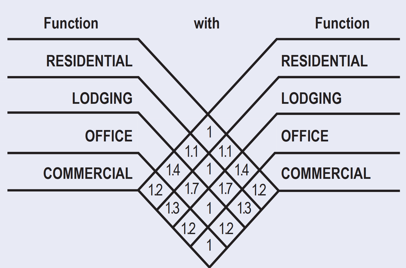
| SHARING FACTOR | The shared Parking Standards Table provides the method for calculating shared parking for buildings with more than one Use type. It refers to the parking requirements that appear in Table 4. The parking required for any two Functions on a Lot is calculated by dividing the number of spaces required by the lesser of the two uses by the appropriate factor from this Table and adding the result to the greater use parking requirement. For instance: for a building with a Residential Use requiring 100 spaces and a Commercial Use requiring 20 spaces, the 20 spaces divided by the sharing factor of 1.2 would reduce the total requirement to 100 plus 17 spaces. For uses not indicated in this chart on a mixed use lot a sharing factor of 1.1 shall be allowed. Additional sharing is allowed by Warrant. Additional sharing is allowed by SAP Permit. |
| |
| OFF-STREET PARKING STANDARDS | ||||
|---|---|---|---|---|
| ANGLE PARKING | ACCESS AISLE WIDTH | • Driveways shall have a minimum of 10 feet of paved width of a one-way drive and 20 feet for a two-way drive for parking area providing 10 or more stalls. • Pedestrian entrances shall be at least 3 feet from stall, driveway or access aisle. • Allowable slopes, paving, and drainage as per Florida Building Code. • Off-street Parking facilities shall have a minimum vertical clearance of 7 feet. Where such a facility is to be used by trucks or loading Uses, the minimum clearance shall be 12 feet Residential and 15 feet Commercial and Industrial. • Ingress vehicular control devices shall be located so as to provide a minimum driveway of 20 feet in length between the Base Building Line and dispenser. • For requirements of parking lots, refer to Article 9 and the City of Miami Off-street Parking Guides and Standards. | ||
| ONE WAY TRAFFIC SINGLE LOADED | ONE WAY TRAFFIC DOUBLE LOADED | TWO WAY TRAFFIC DOUBLE LOADED | ||
90 | 23 ft | 23 ft | 23 ft | |
60 | 12.8 ft | 11.8 ft | 19.3 ft | |
45 | 10.8 ft | 9.5 ft | 18.5 ft | |
| Parallel | 10 ft | 10 ft | 20 ft | |
| Standard stall: 8.5 ft x 18 ft minimum | ||||
| LOADING BERTH STANDARDS | T5, T6, CS, CI-HD & CI | DISTRICT | NOTES | |||||
|---|---|---|---|---|---|---|---|---|
RESIDENTIAL* | From 25,000 sf to 500,000 sf | Berth Types Residential*: 200 sf = 10 ft x 20 ft x 12 ft Commercial**: 420 sf = 12 ft x 35 ft x 15 ft Industrial***: 660 sf = 12 ft x 55 ft x 15 ft * Residential loading berths shall be setback a distance equal to their length. For the N2 block, residential loading berths shall be setback a minimum of ten (10) feet. ** Commercial berth may be substituted by 2 Residential berths. 2 Residential berths may be substituted by 1 Commercial berth. *** 1 Industrial berth may be substituted by 2 Commercial berths. 2 Commercial berths may be substituted by 1 Industrial berth. A required Industrial or Commercial loading berth may be substituted by a Commercial or Residential loading berth, by SAP Permit, if the size, character, and operation of the Use is found to not require the dimensions specified and the required loading berth dimension could not otherwise be provided according to the regulations of this Code. The total number of required loading berths for the One BCC Mixed Use Tower shall be seven (7) Industrial size loading berths and eight (8) Commercial size loading berths.** The total number of required loading berths for the 650 SMA block shall be two (2) Commercial sized loading berths, to be reviewed and approved via SAP Permit. The total number of required loading berths for the AP block shall be one (1) Residential size loading berth plus one (1) Commercial size loading berth for a total of two (2) loading berths, to be reviewed and approved via SAP Permit. Loading Hours shall comply with conditions established by the Development Order. | ||||||
| Berth Size | Loading Berths | |||||||
| 420 sf | 1 per first 100 units | |||||||
| 200 sf | 1 per each additional 100 units or fraction of 100. | |||||||
| Greater than 500,000 sf | ||||||||
| Berth Size | Loading Berths | |||||||
| 660 sf | 1 per first 100 units | |||||||
| 200 sf | 1 per each additional 100 units or fraction of 100. | |||||||
| LODGING | From 25,000 sf to 500,000 sf | From 25,000 sf to 500,000 sf | ||||||
| Berth Size | Loading Berths | Berth Size | Loading Berths | |||||
| 420 sf | 1 per 300 rooms | 420 sf | 1 per 300 rooms | |||||
| 200 sf | 1 per 100 rooms | 200 sf | 1 per 100 rooms | |||||
| Greater than 500,000 sf | Greater than 500,000 sf | |||||||
| Berth Size | Loading Berths | Berth Size | Loading Berths | |||||
| 660 sf | 1 per 300 rooms | 660 sf | 1 per 300 rooms | |||||
| 200 sf | 1 per 100 rooms | 200 sf | 1 per 100 rooms | |||||
OFFICE COMMERCIAL** INDUSTRIAL*** | From 25,000 sf to 500,000 sf | From 25,000 sf to 500,000 sf | ||||||
| Berth Size | Loading Berths | Area | Berth Size | Loading Berths | Area | |||
| 420 sf | 1st | 25K sf-50K sf | 420 sf | 1st | 25K sf-50K sf | |||
| 420 sf | 2nd | 50K sf-100K sf | 420 sf | 2nd | 50K sf-100K sf | |||
| 420 sf | 3rd | 100K sf-250K sf | 420 sf | 3rd | 100K sf-250K sf | |||
| 420 sf | 4th | 250K sf-500K sf | 420 sf | 4th | 250K sf-500K sf | |||
| Greater than 500,000 sf | Greater than 500,000 sf | |||||||
| Berth Size | Loading Berths | Area | Berth Size | Loading Berths | Area | |||
| 660 sf | 1/ | 500K sf | 600 sf | 1/ | 500K sf | |||
| **In a One BCC Signature Office design, required loading berths are subject to standards above, but only up to a maximum of six (6) loading berths with a Loading Management Plan approved by SAP Permit. A Loading Management Plan shall include: the layout of all berths; entry and exit routes; turning maneuverability studies; a requirement to have a dockmaster present for all loading hours; and an operational plan setting forth allowable loading hours, on-site personnel requirements, a radio (or alternate) communication system with drivers to provide advance notice of arrival times, and procedures for moving vehicles when necessary to prevent backups. Additional sharing of loading berths between tenants may be permitted by SAP Permit. | ||||||||
Article 4, Table 6 FRONTAGES
Arcade: a Frontage wherein the Façade includes a cantilevered building or colonnade that overlaps the sidewalk, while the Façade at sidewalk level remains at the Frontage Line. This type is conventional for retail Use. The arcade shall be no less than 8 feet wide and may overlap the whole width of the sidewalk to within 2 feet of the curb. Permitted by Special Area Plan. |
|  | ||
|---|---|---|---|---|
Article 4, Table 7 CIVIC SPACE TYPES
This table describes the standards for areas zoned as Civic Space (CS) and for Public Parks and Open Space provided by the Public Benefits Program.
Civic Space Types may be at multiple levels, landscaped and/or paved, open to the sky and shall be open to the public from 6:00 AM to 10:00 PM. The Civic Space at the NW corner of the One BCC block and on the 650 SMA block can be covered under a building if there is a minimum vertical clear height of 16 feet provided. Civic Space Types may be publicly or privately owned. Open Space requirements for each zone are described in Article 5.
Plaza: An Open Space available for civic purposes and programmed activities. A Plaza shall be spatially defined by Building Frontages and may include street Frontages. Its landscape shall consist primarily of pavement and trees. The minimum size shall be 1/8 acre and the maximum shall be 2 acres. |
|
5.6 URBAN CORE TRANSECT ZONES (T6)
5.6.1 Building Disposition (T6)
e. For the minimum Height, Facades shall be built parallel to the Principal Frontage Line as indicated in the Design Guidelines, Regulating Plan and SAP Plans. In the absence of Building along the remainder of the Frontage Line, a Streetscreen shall be built co-planar with the Façade to shield parking and service areas. In the case of two (2) or three (3) Principal Frontages meeting at Thoroughfare intersections, the Building corner may recede from the designated Setback up to twenty percent (20%) of the Lot length.
f. At the first Story, Facades along a Frontage Line shall have frequent doors and windows; pedestrian entrances shall occur at a maximum of seventy five (75) feet and vehicular entries shall occur at a minimum spacing of sixty (60) feet unless approved by SAP Permit. Principal entrances to retail establishments shall be provided along 7th and 8th Streets and South Miami Avenue. Where a retail establishment is located on the corner of 7th or 8th Street and South Miami Avenue, only one (1) principal entrance shall be required. For the N2 block, pedestrian entrances can occur at a maximum of two hundred (200) feet and vehicular entries can occur at a minimum spacing of ten (10) feet.
i. For the One BCC block, a cross-block passage of 10 feet is required. For the N2 block, a cross-block passage is not required. Instead, pedestrian passages can be provided at the ends of the N2 block. For the 650 SMA and AP blocks a cross-block Paseo providing a clear path of a minimum of ten (10) feet in width, including landscaping, is required from SW 7 Street to S. Miami Avenue (southbound) and from S. Miami Avenue (southbound) to SW Miami Avenue Road, respectively. In no event shall the clear walking path be less than eight (8) feet in width nor shall the landscaping area be less than two (2) feet in width. The Paseo shall be lined with active uses having frequent doors and windows on one-side or be anchored on one end by Civic Space, and any deviations shall be approved by SAP Permit.
For the N2 block, setbacks for Buildings shall be provided as listed below:
- Principal Front Setback on 5th Street: 0' min.; 2' min. above 8th Story
- Principal Front Setback on 6th Street: 0' min.; 20' min. above 8th Story
- Secondary Front Setback on 1st Avenue: 0' min.; 10' min. above 8th Story
For the 650 SMA block, setbacks for Buildings shall be provided as listed below:
- Principal Front Setback on South Miami Avenue (northbound lanes) and on SW 7th Street: 10’ min.; 17’-6” min above the 10th Story
- Secondary Front Setback on South Miami Avenue (southbound lanes): 10’ min.; 20’ min above the 10th Story
- Side Setback (west): 0’ min.; 30’ min. above the 10th Story
For the AP block, setbacks for Buildings shall be provided as listed below:
- Principal Front Setback on SW Miami Avenue Road: 10’ min., 13’ min above the 12th Story
- Secondary Front Setback on South Miami Avenue (southbound lanes): 5’ min.; 8’ min. above the 12th Story
- Side Setback (west): 10’ min,; 13’ min. above the 12th Story
5.6.2 Building Configuration (T6)
b. Above the eighth floor (tenth floor for the One BCC and 650 SMA blocks and twelfth floor for the AP block), the Building Floorplate dimensions shall be limited as follows:
- 30,000 square feet maximum for Residential and Hotel Uses (One BCC block only)
- 24,000 square feet maximum for Residential Uses (650 SMA block only)
- 30,000 square feet maximum for Commercial Uses and for parking
- 250 feet maximum length for Residential Uses
- 250 feet maximum length for Commercial Uses
- In a One BCC Signature Office design, the following additional tower flexibilities may be permitted by process of SAP Permit, so long as the Building does not exceed 2,850,000 square feet of total Floor Area:
- 40,000 square feet maximum Floorplate size for Office and Commercial Uses with a maximum length of 250 feet, on all tower Stories except:
- 60,000 square feet maximum Floorplate size for Office Uses for the first 100 feet of the tower above the maximum Height of the Pedestal, with a maximum Floorplate length of 350 feet.
- 40,000 square feet maximum Floorplate size for Office and Commercial Uses with a maximum length of 250 feet, on all tower Stories except:
c. Encroachments shall be as follows: At the First Layer, cantilevered Awnings and entry canopies may encroach up to one hundred percent (100%) of the depth of the Setback and into the Right-of-Way, except as may be further allowed by Chapter 54 of the City Code. Above the first Story, cantilevered balconies, bay windows, decorative features, and roofs may encroach up to three (3) feet (four (4) feet for the N2 block) of the depth of the Setback. The Climate Ribbon and any above-grade connection(s) spanning the Metromover between BCC East and One BCC blocks have no Setback, and may encroach into the Right-of-Way. Other cantilevered portions of the Building shall maintain the required Setback. Above the Pedestal no Encroachments are permitted, except that Facade components promoting energy efficiency such as shading and Screening devices that are non-accessible may encroach a maximum of three (3) feet.
d. For the N2 block, Galleries and Arcades (which includes cantilevered overhangs) can be ten (10) feet deep, can encroach 100% of the depth of the Setback and can overlap the whole width of the sidewalk to within four (4) feet of the curb on a Primary Frontage and sixteen (16) feet on a Secondary Frontage.
f. Loading and service entries shall be pursuant to the Design Guidelines of the Special Area Plan. Loading may be accessed from all Frontages if architectural treatments applied to exposed spaces create a finished appearance. In a One BCC Signature Office design, all loading may be provided above-ground and enclosed within the Pedestal. At ground level, parking and loading in a One BCC Signature Office design shall be screened by a Liner along the Frontage, unless demonstrated through SAP Permit that it is not practical. However, at ground level along the Metromover (west side of One BCC block), parking and loading in a One BCC Signature Office design may also be screened by an art, glass, or architectural treatment.
h. Mechanical equipment on a roof shall be screened by a parapet wall of a maximum height of twenty-five (25) feet or enclosure and shall conceal all equipment, except antennas, from lateral view. Where possible, equipment other than solar panels shall be enclosed or screened from overhead views.
5.6.4 Parking Standards (T6)
a. Parking shall be required and provided and accessed in accordance with Article 4, Table 5 of Miami 21, the Design Guidelines of this Special Area Plan and as modified in this section of the Regulating Plan.
Parking and loading requirements may be reduced via an SAP Permit, and may include all parking reductions available under the Miami 21 Code, amended as of March 3, 2022. Any other reduction greater than 30% shall require the submittal of a traffic study and/or parking study to support the greater reduction. As set forth in 7.1.2.a of this Regulating Plan any parking reductions allowed in Miami 21 shall be processed through an SAP Permit.
The vehicular entrance of a parking Lot or garage on a Frontage shall have a continuous flush sidewalk crossing and pedestrian safety zones for curb cuts widths over thirty (30) feet.
All parking, including drop-off drives and porte-cocheres, open parking areas, covered parking, garages, Loading Spaces and service areas shall be located in accordance with the Design Guidelines of this Special Area Plan, or otherwise located within the Pedestal for a One BCC Signature Office Design. All Screening utilized to visually shield or obscure the aforementioned areas shall be subject to the review and approval of the Planning Director.
Above ground parking may extend into the Second Layer by SAP Permit, if an art, glass treatment or Architectural Treatment, of a design to be approved by the Planning Director, with the recommendation of the Urban Development Review Board (UDRB), is provided for one hundred (100%) percent of that portion of the Pedestal Façade. In a One BCC Signature Office design, this process shall also apply to all ground-level parking and loading areas.
5.6.5 Architectural Standards (T6)
b. The Facades on Retail Frontages shall be detailed as storefronts and shall, for the first ten (10) feet above the sidewalk elevation, contain windows or doorways of transparent glass covering at least 50% of the linear footage of each Building. The base of all transparent openings shall be no more than two (2) feet above the sidewalk. Display Windows may count up to twenty-five percent (25%) of the transparency requirement if reviewed and approved through a SAP Permit.
For the N2 block, the Facades on Retail Frontages shall be detailed as storefronts and shall contain windows or doorways of transparent glass in accordance with the Design Guidelines of this Special Area Plan.
ILLUSTRATION 5.6 URBAN CORE TRANSECT ZONES (T6-48)
| BUILDING DISPOSITION | |
| LOT OCCUPATION | |
| a. Lot Area | 5,000 s.f. min. |
| b. Lot Width | 100 ft min. |
| c. Lot Coverage | |
| - 1-8 Stories | 80% max. |
| - Above 8th Story | 30,000 sf. max. Floorplate for Residential & Lodging for One BCC Block In a One BCC Signature Office design, the following additional tower flexibilities may be permitted by process of SAP Permit, so long as the Building does not exceed 2,850,000 square feet of total Floor Area: 40,000 square feet maximum Floorplate size for Office and Commercial Uses with a maximum length of 250 feet, on all tower Stories except: 60,000 square feet maximum Floorplate size for Office Uses for the first 100 feet of the tower above the maximum Height of the Pedestal, with a maximum Floorplate length of 350 feet. |
| d. Floor Lot Ratio (FLR) | T6-48a: 11 / 50% additional Public Benefit T6-48a: 18 / 50% additional Public Benefit |
| e. Frontage at front Setback | as per BCC SAP Plans and Design Guidelines |
| f. Open Space | 10% Lot Area min. |
| g. Density | 150 du/ac max. * |
| BUILDING SETBACK | |
| a. Principal Front | 10 ft. min.; 20 ft. min. above 8th Story |
| b. Secondary Front | 10 ft. min.; 20 ft. min. above 8th Story |
| c. Side | 0 ft. min.; 30 ft. min. above 8th Story |
| d. Rear | 0 ft. min.; 30 ft. min. above 8th Story |
| e. Abutting Side or Rear T5 | 0 ft. min. 1st through 5th Story 10 ft. min. 6st through 8th Story 30 ft. min. above 8th Story |
| BUILDING CONFIGURATION | |
| FRONTAGE | |
| a. Common Lawn | prohibited |
| b. Porch & Fence | prohibited |
c. Terrace or L.C | prohibited |
| d. Forecourt | permitted |
| e. Stoop | permitted |
| f. Shopfront | permitted (T6-48-L and T6-48-O only) |
| g. Gallery | permitted by Special Area Plan |
| h. Arcade | permitted by Special Area Plan |
| BUILDING HEIGHT | |
| a. Min. Height | 2 Stories |
| b. Max. Height | 48 Stories |
| c. Max. Benefit Height | 37 Stories (for One BCC block only) 6 Stories for 650 SMA block; 14 Stories for AP block |
* Or as modified in Diagram 9
6.3.2 Open Air Retail
Open Air Retail is a permitted use by right and shall be authorized in the BCC SAP and specifically in the retail concourses.
6.5 Sign Standards - Brickell City Centre SAP
6.5.1 Intent
Brickell City Centre is a pedestrian oriented, mixed-use, urban development district (the “District”) that includes residential, retail, office and hotel uses which are serviced by a mass transit station and several lined parking garages. The District is envisioned as a hub for high-end retail which does not otherwise exist in the City of Miami. The retail and office components of the District will consistently serve large numbers of people, many of whom will drive to the District and park in one of the Project’s several lined parking garages. Others will walk or take mass transit to access the Project. In order for the District to function properly and seamlessly integrate into the Brickell neighborhood, pedestrians must be clearly directed to the mass transit station and retail areas and vehicles must be clearly directed to parking garages.
The intent of these sign regulations is to (1) move pedestrians and vehicle traffic in and out of the District safely and efficiently; (2) promote safe and efficient pedestrian traffic within the District; (3) promote efficient vehicle circulation to and from the parking garages within the District; and (4) identify the District to motorists along adjacent Thoroughfares
6.5.2 Signage Location, Types, and Aggregation.
- Signs within the Brickell City Centre SAP shall be permitted as set forth in Miami 21, unless modified by the Brickell City Centre Regulating Plan and Design Guidelines as set forth below. Signs within Pedestrian Passages, including directional signs containing layout of the retail space and location of retail tenants, which do not contain advertising material visible from the public right-of-way, shall not be regulated by the City.
- Signage placed on the Pedestal or along the District’s Retail Frontages shall be classified as:
- Directional Signage: Directional Signage may be located at the entrances to parking garages and at pedestrian entrances to the Project, as generally depicted in the Design Guidelines. Directional Signage shall be designed to facilitate the movement of both vehicles and pedestrians and direct them to retail, restaurants, parking garages, and other Uses within the District. Directional Signs may range between forty (40) feet in length and four (4) feet in height up to a maximum of one hundred twenty five (125) square feet. Tenants’ names or logos shall not comprise more than 20% of the Area of Directional Signs. Additional regulations governing the location and specifications for Directional Signs may be adopted as part of a Master Sign Package.
- Ground/Freestanding Signage: Ground Signs shall not include Signs mounted on poles or posts in the ground. Ground Signs shall be located at Thoroughfare intersections and along the Principal Frontages, as generally depicted in the Design Guidelines. Signs should not be located within the Visibility Triangle as determined by Public Works or other regulatory agencies, unless it can be determined that such location will not adversely impact public safety. Signs shall be designed and placed in a manner to minimize impact to pedestrian circulation. Ground Signs shall be designed to identify the Project, communicate the District image, or specifically identify a major tenant. Ground signage shall be limited to five (5) signs per block, each with on more than two sign surfaces, neither of which shall exceed forty (40) square feet in Sign Area for each one hundred (100) feet of street Frontage. Permitted Sign Area may be cumulative, but no Sign surface shall exceed one hundred (100) square feet. The Maximum Height shall not exceed twenty (20) feet, including embellishments, as measured from the sidewalks on which the sign is placed. Additional regulations governing the location and specifications for Ground/Freestanding Signs may be adopted as part of a Master Sign Package.
- Wall Signage: Wall Signage shall be located on the Pedestal above the first Floor and oriented toward the street for the purpose of identifying the District and retail tenants of the District. Wall signage can be accommodated on a maximum of twenty-seven percent (27%) of the Pedestal Face (measured by the vertical area from the finished floor elevation to the top of the Pedestal and the horizontal area from setback to setback). Each Pedestal Facade shall be entitled to a minimum of four (4) and a maximum of eight (8) Wall Signs; provided however, that as part of an SAP Permit for a Master Sign Package, the City may approve up to ten (10) Wall signs on a maximum of two (2) Pedestal Facades upon demonstration that the increased number of Wall signs is consistent with Article 4, Table 12 of the Miami 21 Code and the signage standards listed below. Signs located on the Pedestal Facade must be arranged in a manner where each sign acts independently preventing composition signage. Additional regulations governing the maximum size, number, location and specifications for individual Wall Signs may be adopted as part of a Master Sign Package.
- Retail Ribbon Signs: Retail Ribbons Signs shall be counted as Wall Signs for purposes of limiting the number and size of Retail Ribbon Signs. The content of Retail Ribbon Signs shall be limited to advertising for products and services available and events occurring on the premises where the Retail Ribbon Sign is located.
- Tower Signage: Tower signage shall identify the Project or the name of a major tenant occupying more than five percent (5%) of the Floor Area of the tower, excluding parking garages. Tower signage will be located on towers above the Pedestal, in the manner and maximum size depicted in the design guidelines. Each tower shall be entitled to two (2) tower signs. In the event that tower signs are not placed on a tower, such tower signs may be transferred to another tower at a ratio of 2 to 1; however in no event may any one tower be entitled to more than three tower signs.
- The location of signs shall be as generally depicted in the Design Guidelines. The final location of signs may very if approved as part of a Master Sign Package.
- In addition to the signage types referenced in paragraph b. above, the signage types listed in Sec. 6.5.2.5.b.1., 2., and 3. shall also be permitted within the District, subject to the limitations identified therein.
6.5.3 Master Sign Package
- A Master Sign Package for the BCC SAP, or for individual blocks within the BCC SAP, may be submitted to the City for approval by SAP Permit. A Master Sign Package shall include the following: a plan view of each block indicating location of each sign type on each level, specifications for each sign type, and tenant sign restrictions.
- If a Master Sign Package is approved by SAP Permit, all signs which conform to the standards set forth therein shall not require an individual SAP Permit, and shall be permitted if in compliance with the Florida Building Code. If a master sign package is not adopted, or if an individual sign does not conform to the standards set forth in adopted Master Sign Package, such signage may only be approved by SAP Permit.
6.5.4 Signage Standards.
In addition to the standards in Article 4, Table 12 of the Miami 21 Code, the following standards shall be utilized by the Planning Director when evaluating whether a proposed master sign package or individual sign is consistent with the BCC SAP.
a. The District shall provide locations on the commercial areas of the building facade that are specifically designed to accommodate changeable tenant signage. Structure, materials, detailing, and power sources shall be designed with consideration of signage installation requirements and shall be readily adaptable and reparable as tenant sign needs change.
b. Sign illumination shall not be of high intensity. Locations for illuminated signage shall be oriented to the public right-of-way.
c. Orientation of any illuminated sign or light source shall be directed or shielded to the extent practicable.
d. Signs should be designed so as to fit within the architectural features of the facade and related elements and complement the District’s architecture.
e. Indirect and external light sources shall be the preferred option where lighting is required.
f. Small-scale signs projecting from the building face, perpendicular to the public right-of-way, are appropriate for all pedestrian oriented streets.
g. Graphic design for all signs should reflect consistency, simplicity, neatness, and minimum wording to minimize visual clutter and maximize legibility.
h. In order to activate the plaza adjacent to the Metromover station, the City may permit iconic and unique signage on the eastern Pedestal Face of BCC East, as part of a Master Sign Permit.
i. Sign colors should be limited in number and should be compatible with the facade. In most circumstances, dark backgrounds for signs are preferred over light backgrounds.
7.1.2 Permits
Brickell City Centre Development Review Process
The Brickell City Centre development review process is set forth below.
- SAP Permit.
All Development within the Project shall be approved by SAP Permit. In addition, all other permits necessary to develop Property within the Project, such as Warrants, Waivers, Variances, and Exceptions, shall be approved by SAP Permit and subject to the equivalent fee to those established in the Miami 21 Code and Chapter 62 of the City Code. The process and criteria for review and approval of an SAP Permit application is set forth below.- Review and approval process.
- The Zoning Administrator shall review each submitted application for a SAP Permit for completeness within seven (7) days of receipt. Upon verification by the Zoning Administrator, the application shall be referred to the Planning Director. The Planning Director shall review each application for an SAP Permit for consistency with the Brickell City Centre Regulating Plan, Design Guidelines, Development Agreement, Miami 21 and the Miami Comprehensive Neighborhood Plan.
- Review and approval process.
The One BCC block may be developed substantially in accordance with the approved One BCC Mixed Use Tower plans, or any other design that complies with the Brickell City Centre SAP. In a One BCC Signature Office design, development shall proceed by process of SAP Permit and be consistent with pages C2.96 to C2.98 of the One BCC Design Guidelines. To facilitate the purposes of the One BCC Signature Office concept, reasonable modifications to other pages of the Design Guidelines may be allowed by process of SAP Permit, if they otherwise remain in compliance with the SAP Regulating Plan, the Development Agreement, and the overall intent and themes of the Brickell City Centre project.
If the SAP Permit application involves a project in excess of two hundred thousand (200,000) square feet of floor area, it shall be referred to the Coordinated Review Committee, and it may be referred to the Urban Development Review Board. If the SAP Permit application involves a project equal to or less than two hundred thousand (200,000) square feet of floor area, it shall be reviewed by the Planning Director and the Zoning Administrator without need for review by the Coordinated Review Committee, unless the Planning Director determines that such review is necessary. If the application is referred, the committee or board shall review the application and provide its comments and recommendations to the Planning Director.
Where there is no referral to the Coordinated Review Committee, the Planning Director shall issue an intended decision within thirty (30) calendar days of a determination that the application is complete. Where there is referral to the Coordinated Review Committee, the Planning Director shall issue an intended decision within thirty (30) calendar days of the meeting of the Coordinated Review Committee. The applicant shall have seven (7) calendar days from receipt of the notice of the intended decision to request a conference with the Planning Director to discuss revisions or additional information regarding the application. Within ten (10) calendar days of the conference, or if no conference is requested, the Planning Director shall issue written findings and determinations regarding the applicable criteria set forth in this section and any other applicable regulations. The applicant and the Planning Director may mutually consent to an extension of the time for issuance of the final decision. The findings and determinations shall be used to approve, approve with conditions or deny the SAP Permit application.
- The Planning Director shall approve, approve with conditions or deny the SAP Permit application. Approvals shall be granted when the application is consistent with the SAP, inclusive of its Regulating Plan, Design Guidelines, approved Development Agreement, the Miami 21 Code and the Miami Comprehensive Neighborhood Plan, as applicable. Conditional approvals shall be issued when the application requires conditions in order to be found consistent with the SAP, inclusive of its Regulating Plan, Design Guidelines, approved Development Agreement, the Miami 21 Code and the Miami Comprehensive Neighborhood Plan, as applicable. Denials of applications shall be issued if, after conditions and safeguards have been considered, the application still is inconsistent with the SAP, inclusive of its Regulating Plan, Design Guidelines, approved Development Agreement, the Miami 21 Code and the Miami Comprehensive Neighborhood Plan, as applicable. The decision of the Director shall include an explanation of the Code requirements for an appeal of the decision. The Director shall include a detailed basis for denial of an SAP Permit.
- An SAP Permit shall be valid for a period of two (2) years during which a building permit or Certificate of Use must be obtained. This excludes a demolition or landscape permit. A one (1) time extension, for a period not to exceed an additional year, may be obtained if approved by the Planning Director upon written request by the Applicant and subject to the equivalent fee to those established in the Miami 21 Code and Chapter 62 of the City Code.
- Appeal of an SAP Permit to the Planning, Zoning and Appeals Board.
Applicant may file an appeal of the determination of the Planning Director which shall be de novo and taken to the Planning, Zoning and Appeals Board. An appeal shall be filed with the Hearing Boards Office within fifteen (15) calendar days of the posting of decision by the Planning Director on the City’s website. The Board shall determine whether the Permit is upheld or rescinded.
The ruling of the Planning, Zoning and Appeals Board may be further appealed to the City Commission, de novo and must be filed with the Office of Hearing Boards within fifteen (15) calendar days of the Board’s issuance of its ruling. The filing of the appeal shall state the specific reasons for such appeal, together with payment of any required fee. - Modifications to a previously approved SAP Permit
All applications for modifications of an approved SAP Permit shall be submitted in writing to the Zoning Administrator explaining the need for corrections and accompanied by payment of the fee established by the adopted fee schedule. Except for minor modifications, the permit may be amended only pursuant to the procedures and standards established for its original approval. The Zoning Administrator shall review criteria established in the Miami 21 Code to determine the degree of the modification.
All minor modifications shall be referred to the Planning Director for review and compliance with the Regulating Plan, Design Guidelines, approved Development Order, the Miami 21 Code and the Miami Comprehensive Neighborhood Plan, as applicable. If found to be in compliance, the Planning Director shall grant the application for minor modification.
One BCC Alternate Concept Design Guidelines


9.5.3 Trees
b. Street trees shall be of a species typically grown in Miami-Dade County which normally mature to a height of at least twenty (20) feet. Street trees shall have a clear trunk of four (4) feet, an overall height of fifteen (15) feet and a minimum caliper of three (3) inches at time of planting, and shall be provided along all roadways at a maximum average spacing of thirty (30) feet on center, except as otherwise provided in this Article. Where the aforementioned spacing requirement cannot be met, deviations from this standard shall be permitted so long as the total number of street trees provided equals the total number of street required by the thirty (30) feet spacing requirement. The thirty (30) foot average spacing requirement for multiple single family units and townhouse shall be based on the total lineal footage of roadway for the entire project and not based on individual Lot widths. Street trees shall be placed within the swale area or shall be placed on private property where demonstrated to be necessary due to right-of-way obstructions as determined by the Public Works Department. Street trees planted along private roadways shall be placed within seven (7) feet of the edge of roadway pavement and/or where present within seven (7) feet of the sidewalk.
9.5.5 Minimum Number of Trees
Where a conflict exists, the requirement imposing the higher standard shall apply.
o. Street trees of a species typically grown in Miami-Dade County which have a minimum clear trunk of four (4) feet, an overall height of not less than twenty (20) feet, and a minimum caliper of five (5) inches at the time of planting, shall count toward the minimum number of required trees at a ratio of 4 Street Trees-to-1 required Tree.
9.5.6 Shrubs
a. All shrubs shall be a minimum of eighteen (18) inches in height when measured immediately after planting. Shrubs shall be provided at a ratio of ten (10) per required tree. Ground cover may be provided in lieu of shrubs at a ratio of two ground cover plants to one shrub. No less than Thirty (30) percent of the shrubs shall be native species and no less than fifty (50) percent shall be low maintenance and drought tolerant. Eighty (80) percent of the shrubs shall be listed in the Miami-Dade Landscape Manual, the Miami-Dade Street Tree Master Plan and/or the University of Florida’s Low-Maintenance Landscape Plants for South Florida list.