
Miami City Zoning Code
ARTICLE 2
GENERAL PROVISIONS
Amendments to Article 2
| Amendments to Article 2 | |||
|---|---|---|---|
| ORDINANCE | DATE APPROVED | DESCRIPTION | LEGISLATIVE ID |
| 13235 | 11-18-2010 | Minor and non-substantial modifications throughout the Code | 10-00956zt |
| 13114 | 04-12-2022 | Clarifying that the miami 21 code provides a higher standard of zoning for those properties located in the miami-dade county Rapid Transit System Development Zone and providing that all such properties shall remain subject to all of the provisions of thhe Miami 21 Code | 9385 |
2.A MIAMI 21 ATLAS
2.1.1 Title and Purpose
- This Code shall be known as the Miami 21 Code of the City of Miami, Florida. This Code is declared to be in accord with the Miami Comprehensive Neighborhood Plan, as required by the Local Government Comprehensive Planning and Land Development Regulation Act, Section 163.3161 et seq., Florida Statutes (the “Comprehensive Plan”). A primary purpose of this Code is to implement the Comprehensive Plan.
- It is further the purpose of the Miami 21 Code to promote the public health, safety, morals, convenience, comfort, amenities, prosperity, and general welfare of the City and to provide a wholesome, serviceable, and attractive community, including without limitation protection of the environment; conservation of land, energy and natural resources; improved mobility; more efficient use of public funds; greater health benefits of a pedestrian environment; historic preservation; provision of recreational and open spaces; reduction of sprawl; and improvement of the built environment and human habitat.
- To further the goals and objectives of the Comprehensive Plan and the purpose of this Code, the City is divided into Transect Zones (“T-Zones”) of such number, characteristics, area, common unity of purpose, adaptability, or use as will accomplish the goals and objectives of the Comprehensive Plan and this Code.
2.1.2 Intent
The Miami 21 Code is intended to advance the interests of both conservation and development while responding to the existing conditions of the City, its regional context, and its natural features, infrastructure and Buildings.
- The conservation goals include:
- Preserving Neighborhoods, Historical Resources and the natural environment
- Improving the relationship between low Density Residential neighborhoods and adjacent Commercial Corridors with appropriate transitions of Density and Height following the theory of the Transect
- Increasing access to the natural environment through the Baywalk, the Riverwalk, the north-south Greenway, and new Parks
- Conserving energy and reducing carbon dioxide emissions through improved Thoroughfare connectedness to encourage walkability, bicycling and transit use
- Increasing tree canopy
- Encouraging green Buildings
- The development goals include:
- Maintaining the future growth capacity of the City core to ensure its preeminence as the transit-oriented, pedestrian-friendly focus for the region’s economic, civic and cultural activities
- Rebuilding the City’s commercial Corridors to function as Mixed-Use, transit-oriented, walkable centers for adjacent Residential Neighborhoods
- Ensuring that private Development contributes to increased infrastructure capacity, and through building embellishes a pedestrian-friendly public realm of highest ambient quality
- Establishing a rational process for successional growth in areas identified for density and growth
2.1.3 Transect Principles
The Miami 21 Code is intended to encourage the evolution of a settlement pattern based on the organizational principles of the Transect. The Transect is defined as a geographical cross-section that reveals a sequence of environments. Applied to the human or the built environment, the Transect is used to identify and organize a continuum of the physical environment ranging from the least to the most urban.
Transect planning creates coordinated, integrated and harmonious environments, based on the arrangement of all the components to support locational character. Within the range of urban contexts, each different type of location, called a Transect Zone, has development Function, Intensity and Disposition appropriate to the location, and integrates the details of the corresponding public realm. To ensure this integration, the Miami 21 Code controls development on Lots as well as establishes guidelines for the detailing of public right-of-way. For example, narrow streets with open swales find their place in neighborhoods of suburban character, while wide streets with tree lined sidewalks accompany Commercial Development in more intense urban areas.
The Transect encourages the making of places that build on historic character and that evolve over time. This evolution, with the principles enumerated below guiding growth or reduction in Density and Intensity, is called succession. Successional change emerges from a vision of the larger urban context and appropriate transitions across Transect Zones.
The City of Miami’s urban context is comprised of a series of Neighborhoods, Corridors, urban centers, and Districts, each with its own arrangement of Transect Zones. In all cases the goal of transit-oriented, pedestrian-friendly, Mixed-Use urbanism shall guide the arrangement of Transect Zones, Thoroughfares, Buildings and landscape. The specific design of each component should be appropriate to its Transect Zone, as provided in this Code.
Transect Zones are sequential in Intensity: successional zoning changes shall only be permitted sequentially and respecting transitions across Abutting Transect Zones as provided in Article 7.
Transect Zones manifest a range of responses to natural and urban conditions. As described in Article 5, Transect Zones T1, T2 and T3, the least urban, emphasize the presence of the natural environments. Transect Zones T4, T5 and T6, D1, D2 and D3 prioritize the built environment.
Specific to Natural (T1), Rural (T2) and Sub-Urban (T3) Zones, impermeable surface shall be minimized and confined to the ratio of Lot Coverage by Building specified in Article 5. To the extent not inconsistent with applicable state or federal law, storm water management on Thoroughfares may be accomplished through retention and percolation, channeled by curbside swales, or through underground storm drainage channeled by raised curbs.
Specific to General Urban (T4), Urban Center (T5) and Urban Core (T6) Zones, to the extent not inconsistent with applicable state or federal law, the continuity of the urbanized areas should transition to take precedence over the natural environment, except Parks, recreation and natural features. Storm water management on Thoroughfares and Lots shall be implemented primarily through underground storm drainage channeled by raised curbs, and there shall be no retention or detention required on the individual Lots. Impermeable surface shall be confined to the ratio of Lot Coverage by Building specified in Article 5.
2.2.2 Conflicts
Where the requirements of this Miami 21 Code vary with the applicable requirements of any law, statute, rule, regulation, ordinance, or code, the most restrictive or that imposing the higher standard shall govern.
This Code does not abrogate or affect any Easements, covenants, deed restrictions, property owner association rules, or agreements between private parties. Where the regulations set out in this Code are more restrictive than such Easements, covenants, deed restrictions, homeowner association rules, or agreements between private parties, the restrictions of this Code shall govern. Properties located within the Miami-Dade County Rapid Transit System Development Zone or within a Rapid Transit Zone District, as set forth in Chapter 33C of the Miami-Dade County Code, as amended, shall remain subject to all of the provisions of the Miami 21 Code.
2.2.3 Pending Actions and Development Approvals
The effective date of this Miami 21 Code shall not affect nor prevent the prosecution of any action pending at the time of the effective date of this Code, which action is to enforce Ordinance 11000, or the conditions of any development order adopted under Ordinance 11000. The conditions of a development approval under Ordinance 11000 shall continue in full force and effect unless a new approval is obtained, at which time the development shall come into conformance with these regulations if required under Article 7, Section 7.2 “Nonconformities” of this Code.
2.1.3.1 The City - Guiding Principles
- The City should retain its natural infrastructure and visual character derived from its location and climate, including topography, landscape and coastline.
- Growth strategies should encourage Infill and redevelopment.
- New Development should be structured to reinforce a pattern of Neighborhoods and urban centers, focusing growth at transit nodes rather than along Corridors.
- Transportation Corridors should be planned and reserved in coordination with land Use.
- Green Corridors should be encouraged and developed to enhance and connect the urbanized areas.
- The City should include a framework of transit, pedestrian, and bicycle systems that provide alternatives to automobile use.
- A diversity of land use should be distributed throughout the City to enable a variety of economic activity, workplace, residence, recreation and civic activity.
- Affordable and Workforce Housing should be distributed throughout the City to match job opportunities and to avoid concentrations of poverty.
- The City should expand and enhance transit opportunities and connections throughout the City.
2.1.3.2 The Community - Guiding Principles
- Neighborhoods and urban centers should be the preferred pattern of Development and Transect Zones emphasizing single use should be the exception.
- Neighborhoods and Urban centers should be compact, pedestrian-oriented and Mixed-Use. Density and Intensity of Use should relate to degree of transit service.
- The ordinary activities of daily living should occur within walking distance of most dwellings, allowing independence to those who do not drive.
- Interconnected networks of Thoroughfares should be designed to disperse and reduce the length of automobile trips and to encourage walking and bicycling.
- A range of Open Space, including Parks, Squares and Playgrounds, should be distributed within Neighborhoods and urban centers.
- Appropriate building Densities and land uses should occur within walking distance of transit stops.
- Civic, Institutional and Commercial activity should be embedded in Mixed-Use urban centers, not isolated in remote single-use complexes.
- Schools should be located to enable children to walk or bicycle safely to school. New schools should not be located on primary Thoroughfares.
- Within Neighborhoods, a range of housing types and price levels should accommodate diverse ages and incomes.
2.1.3.3 The Block and the Building - Guiding Principles
a. Buildings and landscaping should contribute to the physical definition of Thoroughfares as civic places.
b. Development should adequately accommodate vehicles while respecting the pedestrian and the spatial form of public space.
c. The design of Thoroughfares and Buildings should reinforce safe environments, but not at the expense of accessibility. Designs should incorporate principles of Crime Prevention Through Environmental Design (CPTED).
d. Architecture and landscape design should grow from local climate, topography, history, and building practice.
e. Buildings should allow their inhabitants to experience the geography and climate through energy efficient design.
f. Civic Buildings and public gathering places should be located to reinforce community identity and support self-government.
g. Civic Buildings should be distinctive and appropriate to a role more important than the other Buildings that constitute the fabric of the City.
h. Preservation and renewal of historic resources should be facilitated to affirm the continuity of the community.
i. Harmonious and orderly change and Development of urban areas should be enabled through a form-based zoning code that guides and regulates change.
2.2.1.1
This Code replaces the Zoning Ordinance for the City of Miami, also known as Ordinance 11000 except that Section 627, “SD-27 Midtown Special District” is hereby retained and incorporated as Appendix C hereto and all provisions of Ordinance 11000 referred to in Section 627 shall be applied to Midtown Special District, providing however that within the SD-27 Special District the Planning, Zoning and Appeals Board and procedures related to appeals thereto set out by this Miami 21 Code shall replace the Zoning Board and procedures related to appeals thereto in Ordinance 11000.
Furthermore, Section 616.3, “Miami WorldCenter” is hereby retained and incorporated as Appendix D hereto and all provisions of Ordinance 11000 referred to in Section 616.3 shall be applied to Miami WorldCenter, providing however that within the Miami WorldCenter the Planning, Zoning and Appeals Board and procedures related to appeals thereto set out by this Miami 21 Code shall replace the Zoning Board and procedures related to appeals thereto in Ordinance 11000.
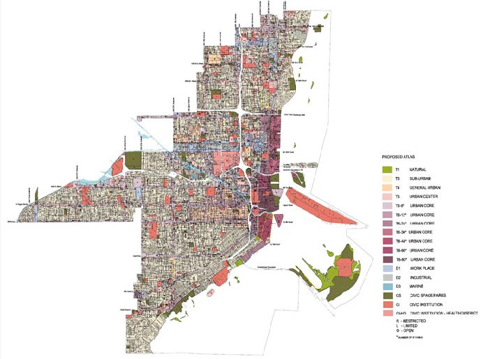
2.2.1.2 Miami 21 Atlas
a. The Miami 21 Atlas is the official Zoning Atlas for the City of Miami. The boundaries of all Transect Zones and the Transect designation are shown on the series of map sheets that compose the Miami 21 Atlas. The Miami 21 Atlas may be supplemented by additional layers or separate maps to the Atlas sheets, where the scale generally applicable to the Atlas sheets does not adequately show the details of boundaries or designations necessary to the particular area.
b. The Miami 21 Atlas, together with all adopted explanatory and supplemental material shown therein, is hereby adopted by reference and shall be part of this Code. The Official Zoning Atlas as adopted by Ordinance 11000 for the same area is hereby repealed.
c. The Miami 21 Atlas, and any amendments thereto, shall be maintained in the office of the City Clerk, and a certified copy of the Miami 21 Atlas shall be maintained at the Planning Department. Each Atlas sheet or supplemental element thereto shall be authenticated by the signature of the Mayor of the City, attested by the signature of the City Clerk of the City, and shall bear the seal of the City.
d. Any proposed amendment to the Miami 21 Atlas shall be identified by reference to the Atlas sheet or supplement involved, in addition to a legal description of the property or such other information as is required to make specific the application of the amendment. Any unauthorized changes to the Miami 21 Atlas shall be considered a violation of this Code and punishable as provided by law.
2.2.1.3
This Code affects all lands, water, Structures, Uses, and occupancies within the area of the City of Miami shown on the Miami 21 Atlas. No Building, Structure, land or water shall be used or occupied, no land shall be subdivided and no Building, Structure, land or part thereof shall be developed except in conformity with the Transect regulations in which it is located and with all applicable regulations in this Miami 21 Code, including lands that are included in the MiamiDade County Rapid Transit Zone.
2.2.4.1
In their interpretation and application, the provisions of this Miami 21 Code shall be the minimum requirements or maximum limitations, as the case may be, adopted for the promotion of the public health, safety, morals or general welfare.
2.2.4.2
The following general rules of construction shall apply to the text of this Code:
a. Headings. Section and subsection headings shall not be deemed to govern, limit, modify, or in any manner affect the scope, meaning, or intent of any provision of the Miami 21 Code.
b. Illustrations. In case of any difference of meaning or implication between the text of any provision and any illustration, the text shall control, unless the intent of the Code is clearly otherwise.
c. Terminology: Shall, may and should. “Shall” is always mandatory and not permissive. “May” is permissive. “Should” is advisory and identifies guidance provided by the City Commission in the implementation of these regulations.
d. Tenses and numbers. Words used in the present tense include the future, words used in the singular include the plural, and the plural includes the singular, unless the context clearly indicates the contrary.
e. Conjunctions. Unless the context clearly indicates otherwise, the following conjunctions shall be interpreted as follows:
1. “And” indicates that all connected items or provisions shall apply.
2. “Or” indicates that the connected items or provisions may apply singly or in any combination.
3. “Either/or” indicates that the connected items or provisions shall apply singly but not in combination.
f. Gender. Use of the masculine gender includes the feminine gender and use of the feminine gender includes the masculine.
g. Any act authorized by this Code to be carried out by a specific official or agency of the City is impliedly authorized to be carried out by a designee of that official or agency.
h. Any reference to federal laws, Florida Statutes, Florida Administrative Code, Miami-Dade County Code, or any other official code shall be construed to be a reference to the most recent enactment of the particular law, and shall include any amendments to it as may be adopted from time to time.
i. Capitalized terms in Articles 2 - 9 refer to Article 1 Definitions.
2.2.4.3 Calculations
a. Rounding. Where cumulative requirements or limitations are to be computed for purposes of this Code, fractions shall be carried forward in the summation, and the total rounded to the nearest whole number, subject to existing minimum Lot sizes and maximum Densities or Intensities of development required by the regulations of this Miami 21 Code.
b. Time. The time within which an act is to be done shall be computed by excluding the first and including the last day, except that if the last day is a Saturday, Sunday or legal holiday, that day shall be excluded.
2.2.5.1
Except as otherwise specifically provided, a Transect symbol or name shown within Transect boundaries in the Miami 21 Atlas indicates that regulations pertaining to the Transect Zone extend throughout the whole area surrounded by the boundary line.
2.2.5.2
Except as provided in Section 2.2.5.3, where a Transect Zone designation is not indicated for an area in the Miami 21 Atlas, the area shall be construed to be zoned as for the most restrictive Abutting Zone, until corrective action shall be taken by the City Commission.
2.2.5.3
Where uncertainty exists as to the location of the boundary of a Transect Zone, or other areas delineated for regulatory purposes in the Miami 21 Atlas, the following rules shall apply:
a. Boundaries indicated as approximately following the centerlines of streets, alleys, rights-of-way, or Easements shall be construed as following such centerlines as they exist on the ground.
b. Boundaries indicated as approximately following boundaries of Thoroughfares, public or private Property Lines, Rights-Of-Way, or Easements shall be construed as following such boundaries. Provided, however, that where such boundaries are so located with relation to other opposing boundaries as to leave such areas without apparent zoning designation, such boundaries shall be construed as running to the centerlines of the areas remaining.
c. Boundaries indicated as approximately following mean high water lines or centerlines of streams, canals, lakes, bays, or other bodies of water shall be construed as following such mean high water lines or centerlines. In the case of a change in mean high water line, the boundary shall be construed as moving with the change.
d. Where variation of the actual location from the mapped location would change the zoning status of a Lot or parcel, the boundary shall be interpreted so as to avoid the change.
e. In the event of vacation, the boundary shall be construed as remaining in its location, except where ownership of the vacated property is divided other than at the center, in which case the boundary shall be construed as moving with the ownership.
2.2.5.4
Boundaries indicated as approximately following City limits shall be construed as following such City limits. Where property previously within the City is removed from its limits, the zoning boundaries involved shall be construed as moving to conform to the change in City limits. Where property previously located outside the City is annexed, zoning boundaries shall not be construed as moving with City limits. In such cases, the City may receive and process permit applications for the property, but no permit shall be issued until the City Commission shall have rezoned the property to establish its zoning status and the permit is found to be in accord with the zoning.
2.2.5.5
Boundaries indicated as entering any body of water, but not continuing to intersection with other Transect boundaries or with the City limits, shall be construed as extending in the direction in which they enter the body of water to intersection with other zoning boundaries or with the City limits.
2.2.5.6
Boundaries indicated as approximately parallel to or extensions of mean high water lines or centerlines of bodies of water shall be construed as being parallel to or extensions of such features.
2.2.5.7
Where distances are not specifically indicated on any map in the Miami 21 Atlas, they shall be determined by reference to the scale of the map.
2.2.5.8
Where boundaries occur within a parcel of land comprising more than one Lot, the Lots shall be developed separately according to the assigned Transect Zone.