
Miami City Zoning Code
Appendix F
Miami Design District Retail Street SAP
SAP 2 MIAMI DESIGN DISTRICT RETAIL STREET
The Miami Design District Retail Street is a mixed-use project in the heart of the Design District situated on certain parcels totaling approximately 25.491 acres, as described in Exhibit "A". The site is generally bounded by Northeast 43rd Street and Northeast 42nd Street to the North, North Federal Highway and Biscayne Boulevard to the East, Northeast 38th Street to the South, and by NE Miami Court and North Miami Avenue to the West, Miami, Florida, as depicted in Sheet A1.5 of the Miami Design District Retail Street Special Area Plan Design Concept Book (the "Concept Book").
SAP 2.1 DEVELOPMENT AGREEMENTS
There are four (4) development agreements associated with the Miami Design District Retail Street SAP, which memorialize the vesting of underlying future land use and zoning, and associated development rights along with specific terms and obligations. Each of the relevant development agreements are listed and defined below, and collectively referenced herein as the "Development Agreements":
- That certain Second Amended and Restated Development Agreement by and between Norwegian Wood Acquisitions, LLC, Oak Plaza Associates (Del.) LLC, Jungle Plaza, LLC, 4200 Associates, LLC, Paradise Plaza Associates, LLC, Half-Circle Property (Del.) LLC, Lovely Rita Acquisitions, LLC, Uptown Girl Development, LLC, Sun King, LLC, Dacra Design 4141 LLC, MDDA Morning Dew, LLC, and Tiny Dancer Acquisitions, LLC, Delaware limited liability companies, and the City of Miami, dated as of August 18, 2021 and recorded in Official Records Book 32694, at Page 850, of the Public Records of Miami-Dade County, Florida, as subsequently amended by that certain Partial Release and Amendment to Second Amended and Restated Development Agreement dated as of ____ 2023 and recorded in Official Records Book _____, at Page _____, of the Public Records of Miami-Dade County, Florida (the "MDDA Development Agreement"). The City Commission approved the most recent version of the MDDA Development Agreement via Ordinance 14246 on December 14, 2023.
- That certain Development Agreement between 4201 NE 2nd AVE LLC and the City of Miami, dated as of April 20, 2015 and recorded in Official Records Book 29595, at Page 4542, of the Public Records of Miami-Dade County, Florida (the "Helm Development Agreement"). The City Commission approved the Helm Development Agreement via Ordinance 13506 on March 12, 2015.
- That certain Development Agreement between Flagler Holding Group, Inc. and the City of Miami, dated as of May 8, 2019 and recorded in Official Records Book 31455, at Page 2659, of the Public Records of Miami-Dade County, Florida, as subsequently amended by that certain First Amendment to Development Agreement dated as of ____ 2023 and recorded in Official Records Book ___, at Page ___, of the Public Records of Miami-Dade County, Florida (the "Flagler Development Agreement"). The City Commission approved the most recent version of the Flagler Development Agreement via Ordinance 14247 on December 14, 2023.
- That certain Development Agreement by and between RFD North 39 LLC, RFD North 40 LLC, RFD South 40 LLC, and the City of Miami, dated as of ____ 2023 and recorded in Official Records Book ___, at Page ___, of the Public Records of Miami-Dade County, Florida (the "RFD Development Agreement"). The City Commission approved the RFD Development Agreement via Ordinance 14245 on December 14, 2023.
SAP 2.2 REGULATING PLAN
SAP 2.3 CONCEPT BOOK
The current versions of the Miami Design District Retail Street SAP Design Concept Book was approved by the City Commission on December 14, 2023 under Ordinance No. 14244. Copies of the Design Concept Book approved under this legislation are on file with the City of Miami and are incorporated herein by reference.
Exhibit "A"
Legal Descriptions of the Property
MAP #1: LAVERNE SUBJECT PROPERTY STREET ADDRESS(ES): SUBJECT PROPERTY LEGAL DESCRIPTION: | 90 NE 39th Street (Folio No.: 01-3124-029-0130) Lots 1, 2 and 3, Block 2, of BILTMORE COURT, according to the Plat thereof, as recorded in Plat Book 7, at Page 37, of the Public Records of Miami-Dade County, Florida |
MAP #2, 3, 4, 5, 6, 7: PALM COURT SUBJECT PROPERTY STREET ADDRESS(ES): SUBJECT PROPERTY LEGAL DESCRIPTION: | 100 NE 39th Street (Folio No.: 01-3124-046-0010) 3851 Ne 1 Avenue(Folio No.: 01-3124-046-0020) 3801 NE 1 Avenue (Folio No.: 01-3124-046-0030) 132 NE 39th Street (Folio No.: 01-3124-046-0040) 140 NE 39th Street (Folio No.: 01-3124-046-0050) 180 NE 39th Street (Folio No.: 01-3124-046-0060) 3821 NE 1 Court (Folio No.: 01-3124-046-0070) Tracts A, B, C, D, E, F and G of PALM WAY SUBDIVISION, according to the Plat thereof, as recorded in Plat Book 170, at Page 32, of the Public Records of Miami-Dade County, Florida. |
MAP #8: BUICK SUBJECT PROPERTY STREET ADDRESS(ES): SUBJECT PROPERTY LEGAL DESCRIPTION: | 3841 NE 2nd Avenue (Folio No.: 01-3219-011-0100) The North 68.32 feet of Lot 2, and all of Lot 3, of SECOND AMENDED PLAT OF MAGNOLIA PARK, according to the Plat thereof, as recorded in Plat Book 5, at Page 25, of the Public Records of Miami-Dade County, Florida, together with that certain twelve-foot strip of land lying adjacent to and immediately East of the above-described property, said twelve-foot strip having for its Easterly boundary the Florida East Coast Railroad right-of-way. |
MAP #9: TUTTLE SOUTH SUBJECT PROPERTY STREET ADDRESS(ES): SUBJECT PROPERTY LEGAL DESCRIPTION: | 3725 Biscayne Boulevard (Folio No.: 01-3219-045-0010) Tract A of VIA TUTTLE SUBDIVISION, according to the plat thereof, as recorded in Plat Book 163, at Page 59, of the Public Records of Miami-Dade County, Florida formerly described as: Lot 32, less that part in Biscayne Boulevard, and Lots 33 through 36, less the West 6 feet thereof, MAGNOLIA PARK, 2ND AMENDED PLAT THEREOF, according to the Plat thereof, as recorded in Plat Book 5, at Page 25, of the Public Records of Miami-Dade County, Florida; AND Lots 33, 35 and 37, of BUENA VISTA BISCAYNE BADGER CLUB SUBDIVISION, according to the Plat thereof, as recorded in Plat Book 1, at Page 115, of the Public Records of Miami-Dade County, Florida; AND The North 34.88 feet of Lot 31 of BUENA VISTA BISCAYNE BADGER CLUB SUBDIVISION, according to the Plat thereof, as recorded in Plat Book 1, at Page 115, of the Public Records of Miami-Dade County, Florida; AND The East one foot of the West 6 feet of Lot 36, MAGNOLIA PARK, 2ND AMENDED PLAT THEREOF, according to the Plat thereof, as recorded in Plat Book 5, at Page 25, of the Public Records of Miami-Dade County, Florida. |
MAP #10: TUTTLE NORTH SUBJECT PROPERTY STREET ADDRESS(ES): SUBJECT PROPERTY LEGAL DESCRIPTION: | 299 NE 38th Street (Folio No.: 01-3219-011-0330) Lots 37, 38 and 39, SECOND AMENDED PLAT OF MAGNOLIA PARK, less right of way of Biscayne Boulevard, according to the plat thereof, as recorded in Plat Book 5, at Page 25, of the Public Records of Miami-Dade County, Florida. |
MAP #11, 12: SWEET BIRD SOUTH (f/k/a Norwegian Wood and Casa/Lady Jane) SUBJECT PROPERTY STREET ADDRESS(ES): SUBJECT PROPERTY LEGAL DESCRIPTION: | 92 NE 40th Street (Folio No.: 01-3124-029-0010) 99 NE 39th Street Lots 1, 2 and 3, Block 3, of AMENDED PLAT OF COMMERCIAL BILTMORE 1921, according to the Plat thereof, as recorded in Plat Book 6, at Page 132, of the Public Records of Miami-Dade County, Florida. And Lots 1 and 2, Block 1, of BILTMORE COURT, according to the Plat thereof, as recorded in Plat Book 7, at Page 37, of the Public Records of Miami-Dade County, Florida. |
MAP #13, 14: JBL (f/k/a JBL and Hale Daniel) SUBJECT PROPERTY STREET ADDRESS(ES): SUBJECT PROPERTY LEGAL DESCRIPTION: | (Folio No.: 01-3124-030-0090) 101 NE 39th Street 103 NE 39th Street 105 NE 39th Street 107 NE 39th Street 111 NE 39th Street 3907 NE 1st Avenue 3911 NE 1st Avenue Subtract A: Lot 11 and the East 3 feet of Lot 12, in Block 1, of MAGNOLIA COURT, according to the Plat thereof, as recorded in Plat Book 6, at Page 105, of the Public Records of Miami- Dade County, Florida. Subtract B: Parcel 1: Lots 21, 22 and 23, of SECOND SECTION, COMMERCIAL BILTMORE 1924, according to the plat thereof, as recorded in Plat Book 12, at Page 44, of the Public Records of Miami-Dade County, Florida. Parcel 2: Lot “A”, of BILTMORE COURT, according to the Plat thereof, as recorded in Plat Book 7, at Page 37 of the Public Records of Miami-Dade County, Florida. Parcel 3: Unnumbered Lot 13 x 100 feet East of Moore Parkway and West of J.W. Wallace Tract, COMMERCIAL BILTMORE, according to the Plat thereof, as recorded in Plat Book 6, at Page 132, of the Public Records of Miami-Dade County, Florida. Parcel 4: Lot 12, less the East 3 feet thereof, and Lot 13, in Block 1, of MAGNOLIA COURT, according to the Plat thereof, as recorded in Plat Book 6, at Page 105, of the Public Records of Miami-Dade County, Florida, less that part of said Lot 13 described as follows: Beginning at the Southwesterly corner of Lot 13, Block 1, of MAGNOLIA COURT, according to the Plat thereof, as recorded in Plat Book 6, at Page 105, of the Public Records of Miami-Dade County, Florida; thence run Eastwardly along the Southerly line of said Lot 13, a distance of Twelve (12) feet to a point of curve; thence run Westwardly and Northwestwardly along the arc of a tangential curve to the right, having a radius of Twenty-Five (25) feet and a central angle of 8°41’07” for a distance of 12.52 feet to a point on the Westerly line of said Lot 13; thence run Southwardly along the Westerly line of said Lot 13 a distance of 3.07 feet to the Point of Beginning. |
MAP #15: OAK PLAZA-OP 120 (f/k/a Collins) SUBJECT PROPERTY STREET ADDRESS(ES): SUBJECT PROPERTY LEGAL DESCRIPTION: | 139 NE 39th Street (Folio No.: 01-3124-030-0060) LOTS 7 THROUGH 9, INCLUSIVE, BLOCK 1, MAGNOLIA COURT, ACCORDING TO THE PLAT THEREOF, AS RECORDED IN PLAT BOOK 6, AT PAGE 105, OF THE PUBLIC RECORDS OF MIAMI-DADE COUNTY, FLORIDA, LESS AND EXCEPT THAT PORTION OF SAID LOT 7 LYING EASTERLY OF THE SOUTHERLY PROLONGATION OF THE WESTERLY LINE OF THE EAST 5.00 FEET OF LOT 12, SECOND SECTION, COMMERCIAL BILTMORE, AS RECORDED IN PLAT BOOK 12, AT PAGE 44, OF THE PUBLIC RECORDS OF MIAMI-DADE COUNTY, FLORIDA, SAID PORTION OF LOT 7 BEING MORE PARTICULARLY DESCRIBED AS FOLLOWS: BEGIN AT THE SOUTHEAST CORNER OF SAID LOT 7; THENCE SOUTH 89°58'58" WEST ALONG SOUTH BOUNDARY OF SAID LOT 7, FOR A DISTANCE OF 43.98 FEET; THENCE NORTH 00°01'50" WEST ALONG THE SOUTHERLY PROLONGATION OF THE WESTERLY LINE OF THE EAST 5.00 FEET OF SAID LOT 12, FOR A DISTANCE OF 93.23 FEET TO THE NORTH BOUNDARY OF SAID LOT 7; THENCE NORTH 89°59'41" EAST ALONG THE NORTH BOUNDARY OF SAID LOT 7, FOR A DISTANCE OF 43.98 FEET TO THE NORTHEAST CORNER OF SAID LOT 7; THENCE SOUTH 00°01'50" EAST ALONG THE EAST BOUNDARY OF SAID LOT 7, FOR A DISTANCE OF 93.22 FEET TO THE POINT OF BEGINNING. |
MAP #16: OAK PLAZA OP 110 (f/k/a Loggia) SUBJECT PROPERTY STREET ADDRESS(ES): SUBJECT PROPERTY LEGAL DESCRIPTION: | 163 NE 39th Street (Folio No.: 01-3124-030-0050) LOT 6 AND THAT PORTION OF LOT 7, BLOCK 1, MAGNOLIA COURT, ACCORDING TO THE PLAT THEREOF, AS RECORDED IN PLAT BOOK 6, AT PAGE 105, OF THE PUBLIC RECORDS OF MIAMI-DADE COUNTY, FLORIDA, LYING EASTERLY OF THE SOUTHERLY PROLONGATION OF THE WESTERLY LINE OF THE EAST 5.00 FEET OF LOT 12, SECOND SECTION, COMMERCIAL BILTMORE, AS RECORDED IN PLAT BOOK 12, AT PAGE 44, OF THE PUBLIC RECORDS OF MIAMI-DADE COUNTY, FLORIDA, SAID PORTION OF LOT 7 BEING MORE PARTICULARLY DESCRIBED AS FOLLOWS: BEGIN AT THE SOUTHEAST CORNER OF SAID LOT 7; THENCE SOUTH 89°58'58" WEST ALONG SOUTH BOUNDARY OF SAID LOT 7, FOR A DISTANCE OF 43.98 FEET; THENCE NORTH 00°01'50" WEST ALONG THE SOUTHERLY PROLONGATION OF THE WESTERLY LINE OF THE EAST 5.00 FEET OF SAID LOT 12, FOR A DISTANCE OF 93.23 FEET TO THE NORTH BOUNDARY OF SAID LOT 7; THENCE NORTH 89°59'41" EAST ALONG THE NORTH BOUNDARY OF SAID LOT 7, FOR A DISTANCE OF 43.98 FEET TO THE NORTHEAST CORNER OF SAID LOT 7; THENCE SOUTH 00°01'50" EAST ALONG THE EAST BOUNDARY OF SAID LOT 7, FOR A DISTANCE OF 93.22 FEET TO THE POINT OF BEGINNING. |
MAP #17: OAK PLAZA KVA OP 150 (Fendi) SUBJECT PROPERTY STREET ADDRESS(ES): SUBJECT PROPERTY LEGAL DESCRIPTION: | 150 NE 40th Street (Folio No.: 01-3124-028-0080) The West 20 feet of Lot 12, and all of Lot 13, of COMMERCIAL BILTMORE, SECOND SECTION, according to the plat thereof, as recorded in Plat Book 12, at Page 44, of the Public Records of Miami-Dade County, Florida. Also known as: The West 20 feet of Lot 12, and all of Lot 13, of SECOND SECTION, COMMERCIAL BILTMORE 1924, according to the plat thereof, as recorded in Plat Book 12, at Page 44, of the Public Records of Miami-Dade County, Florida. |
MAP #18: OAK PLAZA OP 160 SUBJECT PROPERTY STREET ADDRESS(ES): SUBJECT PROPERTY LEGAL DESCRIPTION: | 160 NE 40th Street (Folio No.: 01-3124-028-0060) 154 NE 40th Street (Folio No.: 01-3124-028-0070) Lots 10, 11 and the East 5 feet of Lot 12, of SECOND SECTION, COMMERCIAL BILTMORE 1924, according to the plat thereof, as recorded in Plat Book 12, at Page 44, of the Public Records of Miami-Dade County, Florida. |
MAP #19: TOMAS MAIER SUBJECT PROPERTY STREET ADDRESS(ES): SUBJECT PROPERTY LEGAL DESCRIPTION: | 170 NE 40th Street (Folio No.: 01-3124-028-0040) Lots 7 and 8, of SECOND SECTION, COMMERCIAL BILTMORE 1924, according to the Plat thereof, as recorded in Plat Book 12, at Page 44, of the Public Records of Miami-Dade County, Florida. |
MAP #20: MELIN SUBJECT PROPERTY STREET ADDRESS(ES): SUBJECT PROPERTY LEGAL DESCRIPTION: | 3930 NE 2nd Avenue (Folio No.: 01-3124-028-0010) Lots 1 through 6 inclusive, of SECOND SECTION, COMMERCIAL BILTMORE 1924, according to the plat thereof, as recorded in Plat Book 12, at Page 44, of the Public Records of Miami-Dade County, Florida, and Lots 1 through 4, inclusive, Block 1, and unnumbered Lot East of Lot 4, Block 1, of MAGNOLIA COURT, according to the plat thereof, as recorded in Plat Book 6, at Page 105, of the Public Records of Miami-Dade County, Florida. LESS Those portions of Lots 1, 2 and 3, Block 1, MAGNOLIA COURT, according to the plat thereof, as recorded in Plat Book 6, at Page 105, of the Public Records of Miami-Dade County, Florida, being more particularly described as follows: The East 10 feet of Lots 1, 2 and 3, and the external area of a circular curve, contained within said Lot 3, concave to the Northwest having a radius of 25 feet and tangents which are 25 feet North of and parallel with the centerline of N.E. 39th Street and 35 feet West of and parallel with the centerline of N.E. 2nd Avenue; AND LESS Those portions of Lots 1, 2 and 3, SECOND SECTION, COMMERCIAL BILTMORE 1924, according to the plat thereof, as recorded in Plat Book 12, at Page 44, of the Public Records of Miami-Dade County, Florida, being more particularly described as follows: The East 2 feet of Lots 1, 2 and 3, and the external area of a circular curve, contained within said Lot 3, concave to the Southwest having a radius of 25 feet and tangents which are 33 feet South of and parallel with the centerline of N.E. 40th Street and 35 feet West of and parallel with the centerline of N.E. 2nd Avenue. |
MAP #21: (NEWTON) SUBJECT PROPERTY STREET ADDRESS(ES): SUBJECT PROPERTY LEGAL DESCRIPTION: | 201 NE 39th Street (Folio No.: 01-3129-012-0010) Lots 1 and 2 and the 10.00-foot Easterly adjacent alley, PLAT SHOWING RESUBDIVISION OF LOTS 4-5-6 & 7 OF SECOND AMENDED PLAT OF MAGNOLIA PARK, according to the Plat thereof, as recorded in Plat Book 4, at Page 150, of the Public Records of Miami-Dade County, Florida. |
MAP #22, 23: (SWEET BIRD NORTH) (f/k/a Asi-Museum Village and Suttin and Lovely Rita) SUBJECT PROPERTY STREET ADDRESS(ES): SUBJECT PROPERTY LEGAL DESCRIPTION: | 81 NE 40th Street and 95 NE 40th Street (Folio No.: 01-3124-049-0020) Tract B, MUSEUM SUBDIVISION, according to the Plat thereof, as recorded in Plat Book 172, Page 98, of the Public Records of Miami-Dade County, Florida. Formerly known as: Lots 5, 6 and 7, Block 2, of AMENDED PLAT OF COMMERCIAL BILTMORE 1921, according to the Plat thereof, as recorded in Plat Book 6, at Page 132, of the Public Records of Miami-Dade County, Florida. And Lots 1, 2, 3 and 4, Block 2, AMENDED PLAT OF COMMERCIAL BILTMORE 1921, as according to the Plat thereof, as recorded in Plat Book 6, at Page 132, of the Public Records of Miami-Dade County, Florida. |
MAP #24, 25, 26, 27, 35, 36, 37, 38: (BRIDGE NORTH, BRIDGE SOUTH, JADE, MOSAIC, MOORE/GARDEN) (f/k/a Rosen, Mosaic/Chatham, Moore-Garden, Moore, Moore 140, Mosaic Lot, Rosen Lot, Palmer Building) SUBJECT PROPERTY STREET ADDRESS(ES): SUBJECT PROPERTY LEGAL DESCRIPTION: | 140 NE 41st Street (Folio No.: 01-3124-048-0020) 150 NE 41st Street (Folio No.: 01-3124-048-0030) 175 NE 40th Street (Folio No.: 01-3124-048-0040) 155 NE 40th Street (Folio No.: 01-3124-048-0050) 151 NE 40th Street (Folio No.: 01-3124-048-0060) Tracts B, C, D, E and F, of BRIDGE SUBDIVISION, according to the Plat thereof, as recorded in Plat Book 171, at Page 100, of the Public Records of Miami-Dade County, Florida. Said Tracts B (Bridge North), C (Jade), D (Moore/Garden), E (Mosiac) and F (Bridge South) of said Plat formerly having been described as Tracts 10, 11, 14 and a portion of vacated alleys more particularly described as follows: (Moore/Garden) Parcel 1: Lots 3, 5, 6 and 7, of AMENDED PLAT OF A PORTION OF BLOCK 10 OF BILTMORE SUBDIVISION AND A PORTION OF BLOCK 1 OF THE AMENDED PLAT OF COMMERCIAL BILTMORE SUBDIVISION, according to the Plat thereof, as recorded in Plat Book 45, at Page 55, of the Public Records of Miami-Dade County, Florida. Parcel 2: Lots 1 and 2, in Block 10, of BILTMORE, according to the Plat thereof, as recorded in Plat Book 6, at Page 67, of the Public Records of Miami-Dade County, Florida. Parcel 3: Lots 2, 3 and 4, in Block 1, of AMENDED PLAT OF COMMERCIAL BILTMORE 1921, according to the Plat thereof, as recorded in Plat Book 6, at Page 132, of the Public Records of Miami-Dade County, Florida. Together with:
(Mosaic / Bridge South) Parcel 1: Lots 8, 9, 10, 11 and 12, Block 1, of AMENDED PLAT OF COMMERCIAL BILTMORE 1921, according to the plat thereof, as recorded in Plat Book 6, at Page 132, of the Public Records of Miami-Dade County, Florida. Together with: A portion of the 12 foot Alley lying North of Block 1, AMENDED PLAT OF COMMERCIAL BILTMORE 1921, according to the Plat thereof, as recorded in Plat Book 6, at Page 132, of the Public Records of Miami-Dade County, Florida, being more particularly described as follows: BEGIN at the Northeast corner of Lot 8, Block 1, AMENDED PLAT OF COMMERCIAL BILTMORE 1921; thence S89°59'47"W along the North line of said Block 1 for a distance of 112.14 feet; thence N00°00'06"E for a distance of 6.00 feet; thence N89°59'47"E along the centerline of 12 foot Alley, for a distance of 112.13 feet; thence S00°03'19"E along the Northerly prolongation of the East line of said Lot 8, for a distance of 6.00 feet to the POINT OF BEGINNING. Parcel 2: Lots 13 and 14, Block 1 of AMENDED PLAT OF COMMERCIAL BILTMORE 1921, according to the Plat thereof, as recorded in Plat Book 6, at Page 132, of the Public Records of Miami-Dade County, Florida. Together with:
(Jade and Bridge North) Parcel 1: Lot 6, in Block 10, of BILTMORE, according to the Plat thereof, as recorded in Plat Book 6, at Page 67, of the Public Records of Miami-Dade County, Florida. Parcel 2: Lot 7, in Block 10, of BILTMORE, according to the plat thereof, as recorded in Plat Book 6, at Page 67, of the Public Records of Miami-Dade County, Florida. Parcel 3: Lot 5 and the West 20 feet of Lot 4, Block 10, BILTMORE, according to the Plat thereof, as recorded in Plat Book 6, at Page 67, of the Public Records, Miami-Dade County, Florida, Excepting therefrom the following part of the West 20 feet of Lot 4: Begin at the Southwest corner of said Lot 4, Block 10, of the aforesaid BILTMORE; thence East along the South line of said Lot 4 for a distance of 20 feet; thence North parallel with the West line of said Lot 4 for a distance of 20 feet to a point; thence Southwesterly along a tangent circular curve having a radius of 20 feet through a central angle of 90 degrees for an arc distance of 31.42 feet to the Point of Beginning. Parcel 4: Lot 8, in Block 10, of BILTMORE, according to the Plat thereof, as recorded in Plat Book 6, at Page 67, of the Public Records of Miami-Dade County, Florida. Together with:
|
MAP #28, 29, 30, 31, 32, 33, 34: MUSEUM GARAGE (f/k/a Asi-Museum Village) SUBJECT PROPERTY STREET ADDRESS(ES): SUBJECT PROPERTY LEGAL DESCRIPTION: | (Folio No.: 01-3124-049-0010) 90 NE 41st Street Tract A, of MUSEUM SUBDIVISION, according to the Plat thereof, as recorded in Plat Book 172, at Page 98, of the Public Records of Miami-Dade County, Florida.
Vacated Alley: A portion of the 12 foot alley lying between Block 9, of BILTMORE according to the plat thereof as recorded in Plat Book 6, Page 67, and Block 2 of AMENDED PLAT OF COMMERCIAL BILTMORE according to the plat thereof as recorded in Plat Book 6, Page 132, of the Public Records of Miami-Dade County, Florida, being more particularly described as follows:
|
MAP #41, 62: STARDUST WEST (f/k/a Moore 77 and Uptown Girl) SUBJECT PROPERTY STREET ADDRESS(ES): SUBJECT PROPERTY LEGAL DESCRIPTION: | 4100 NE 1st Avenue (Folio No.: 01-3124-024-1350) 77 NE 41st Street (Folio no.: 01-3124-024-1340) Parcel 1: Lot 22 and the East ½ of Lot 21, in Block 8, of BILTMORE, according to the Plat thereof, recorded in Plat Book 6, at Page 67, of the Public Records of Miami-Dade County, Florida. Parcel 2: Lots 23 and 24, less the North 46 feet thereof, in Block 8, of BILTMORE, according to the Plat thereof, recorded In Plat Book 6, at Page 67, of the Public Records of Miami-Dade County, Florida. |
MAP #42, 43, 44: PARADISE PLAZA (f/k/a Moore 115, Scarlet Begonia, Church (FCAA)) SUBJECT PROPERTY STREET ADDRESS(ES): SUBJECT PROPERTY LEGAL DESCRIPTION: | 115 NE 41st Street (Folio No.: 01-3124-024-1550) 135 NE 41st Street (Folio No.: 01-3124-024-1550) 150 NE 42nd Street (Folio No.: 01-3124-024-1550) Parcel 1: The West 325 feet of that certain tract of land in the city of Miami bounded on the North by N.E. 42nd Street, on the South by N.E. 41st Street, on the East by N.E. Second Avenue and on the West by the East lines of Lots 5 and 6, Block 7, BILTMORE, a subdivision shown by plat of record in Miami-Dade County, in Plat Book 6, at Page 67. Also known as: A portion of the West 325 feet of that certain Lot of Land, 432 feet East and West and 204.6 feet North and South, lying directly East of and adjoining Lots 5 and 6, Block 7, of BILTMORE, according to the Plat thereof, as recorded in Plat Book 6, at Page 67, of the Public Records of Miami-Dade County, Florida, of said Plat shown as Z.T. MERRITT HOME, said Lot lying in the Southeast corner of the NE 1/4 of the SE 1/4 of section 24-53-41. Parcel 2: Lot 5, Block 7, of BILTMORE, according to the Plat thereof, as recorded in Plat Book 6, at Page 67, of the Public Records of Miami-Dade County, Florida. Parcel 3: Lots 3 and 4, in Block 7, of BILTMORE, according to the Plat thereof, as recorded in Plat Book 6, at Page 67, of the Public Records of Miami-Dade County, Florida. |
MAP #45: 4100/Lee SUBJECT PROPERTY STREET ADDRESS(ES): SUBJECT PROPERTY LEGAL DESCRIPTION: | 4100 NE 2nd Avenue (Folio No.: 01-3124-024-1560) The East 107 feet of that certain tract of land 432 feet East and West by 204.6 feet North and South, lying directly East of and adjoining Lots 5 and 6, in Block 7, of BILTMORE, according to the Plat thereof, as recorded in Plat Book 6, at Page 67, of the Public Records of Miami-Dade County, Florida. |
MAP #46: 4141 SUBJECT PROPERTY STREET ADDRESS(ES): SUBJECT PROPERTY LEGAL DESCRIPTION: | 4141 NE 2nd Avenue (Folio No.: 01-3219-009-0010) Tract A and Tract 1, REVISED PLAT OF TRACT "A" AND BLOCKS 1, 2, 3, 8, 9, 10, 11 AND 12 OF BRENTWOOD, according to the plat thereof, as recorded in Plat Book 44, Page 6, of the Public Records of Miami-Dade County, Florida, formerly known as Tract "A" and Lots 1, 2, 3, 4 and 5, Block 1, of BRENTWOOD, according to the plat thereof as recorded in Plat Book 40, Page 66, of the Public Records of Miami - Dade County, Florida. |
MAP #47: 4200 SUBJECT PROPERTY STREET ADDRESS(ES): SUBJECT PROPERTY LEGAL DESCRIPTION: | 4200 NE 2nd Avenue (Folio No.: 01-3124-024-0930) Lot 1, less the East 5 feet thereof, Block 6, of BILTMORE, according to the Plat thereof, as recorded in Plat Book 6, at Page 67, of the Public Records of Miami-Dade County, Florida. |
MAP #48: Flagler SUBJECT PROPERTY STREET ADDRESS(ES): SUBJECT PROPERTY LEGAL DESCRIPTION: | 4218 NE 2nd Avenue (Folio No. 01-3124-024-0940) LOT 2, 3 AND 24, BLOCK 6, BILTMORE, ACCORDING TO THE PLAT THEREOF, AS RECORDED IN PLAT BOOK 6, AT PAGE 67, OF THE PUBLIC RECORDS OF MIAMI-DADE COUNTY, FLORIDA. |
MAP #49: 4240 SUBJECT PROPERTY STREET ADDRESS(ES): SUBJECT PROPERTY LEGAL DESCRIPTION: | 4240 NE 2nd Avenue (Folio No.: 01-3124-024-0950) Lot 4, less the East 5 feet thereof, in Block 6, BILTMORE, as recorded in Plat Book 6, Page 67, of the Public Records of Miami-Dade County, Florida. |
MAP #50, 51: CITY GARAGE (f/k/a City Garage, Sebastien) SUBJECT PROPERTY STREET ADDRESS(ES): SUBJECT PROPERTY LEGAL DESCRIPTION: | 3800 NE 1st Avenue (Folio No.: 01-3124-033-0240) Parcel 1: Lots 2, 3, 4, 5, 6, 7, 8, 9, 10, 11, 12, 13 and 14, in Block 2, of COMMERCIAL BUENA VISTA, according to the Plat thereof, as recorded in Plat Book 14, at Page 56, of the Public Records of Miami-Dade County, Florida. Parcel 2: Lots 15, 16, 17 and 18, Block 2, of COMMERCIAL BUENA VISTA, according to the Plat thereof, as recorded in Plat Book 14, at Page 56, of the Public Records of Miami-Dade County, Florida. Less the following portion of Lot 18, Block 2, of COMMERCIAL BUENA VISTA, according to the Plat thereof, as recorded in Plat Book 14, at Page 56, of the Public Records of Miami-Dade County, Florida, as conveyed to the City of Miami by Right-of-Way Deed, recorded May 18, 2015, in Official Records Book 29619, at Page 3235, being more particularly described as follows:
|
MAP #52, 53: PENNY LANE (f/k/a Spear, Always Flowers) SUBJECT PROPERTY STREET ADDRESS(ES): SUBJECT PROPERTY LEGAL DESCRIPTION: | 50 NE 39th Street (Folio No.: 01-3124-029-0150) Parcel 1: That portion of Lots 19, 20 and 21, of Block 2, COMMERCIAL BUENA VISTA, according to the Plat thereof, as recorded in Plat Book 14, at Page 56, of the Public Records of Miami-Dade County, Florida, lying West of the West line of Lot 6, of Block 2, of BILTMORE COURT, according to the Plat thereof, as recorded in Plat Book 7, at Page 37, of the Public Records of Miami-Dade County, Florida. Parcel 2: All of Lot 7 and Lot 8, less the following described property: Beginning at the Northeast corner of Lot 8, in Block 2, of BILTMORE COURT, according to the Plat thereof, as recorded in Plat Book 7, at Page 37, of the Public Records of Dade County, Florida now known as Miami-Dade County, Florida; thence run West along the North line of said Lot 8, a distance of 50.02 feet to the Northwest corner of said Lot 8; thence run South along the West line of said Lot 8, a distance of 89.30 feet to the Southwest corner of said Lot 8; thence run East along the South line of said Lot 8, a distance of 30.92 feet to a point; thence run North along a line parallel with and 30.92 feet East of the West line of said Lot 8, for a distance of 70.27 feet to a point of curve; thence run Northerly and Easterly along the arc of a curve having a radius of 19.15 feet and a central angle of 90°02'53" for an arc distance of 30.10 feet to the Northeast corner of said Lot 8, which is the point of beginning, all in Block 2, of BILTMORE COURT, according to the Plat thereof, as recorded in Plat Book 7, at Page 37, of the Public Records of Dade County, Florida, now known as Miami-Dade County, Florida. AND LESS the following described lands conveyed to the City of Miami by Right-of-Way Deed, recorded February 28, 2017, in Official Records Book 30436, at Page 3942: A portion of Lot 7 and Lot 8, Block 2, BILTMORE COURT, according to the Plat thereof, as recorded in Plat Book 7, at Page 37, of the Public Records of Miami-Dade County, Florida, being more particularly described as follows: The external area of a circular curve lying within Lots 7 and 8, in Block 2, of BILTMORE COURT, according to the Plat thereof, as recorded in Plat Book 7, at Page 37, of the Public Records of Miami-Dade County, Florida, said circular curve being concave to the Southeast, having a radius of 25 feet, and tangents which are 25 feet South of and parallel with the center line of N.E. 39th Street and 20 feet East of and parallel with the center line of N.E. Miami Court. |
MAP #54, 55, 56: LIDIA (f/k/a Lidia) SUBJECT PROPERTY STREET ADDRESS(ES): SUBJECT PROPERTY LEGAL DESCRIPTION: | 30 NE 39th Street (Folio No.: 01-3124-029-0160) 3840 NE Miami Court (Folio No.: 01-3124-026-0220 3825 N. Miami Avenue (Folio No.: 01-3124-029-0170) Parcel 4A: Lot 9, less the East 15 feet, and Lots 10 through 13, Inclusive, Block 2, of BILTMORE COURT, according to the Plat thereof, as recorded In Plat Book 7, at Page 37, of the Public Records of Miami-Dade County, Florida, LESS that portion of Lot 11, Block 2, taken by Eminent Domain pursuant to Final Judgment under Clerks File No. 69R-17950, described as follows: All that part of Lot 11, Block 2, of BILTMORE COURT, which lies within the external area formed by a 25 foot radius are, concave to the Southeast, tangent to the North line of said Lot 11 and tangent to a line that is 10 feet East and parallel to the West line of said Lot 11. And Parcel 4B Lot 4, less the West 15 feet, and Lot 5, Block 3, of CENTRAL ADDITION BUENA VISTA, according to the Plat thereof, as recorded in Plat Book 3, at Page 191, of the Public Records of Miami-Dade County, Florida. |
MAP #57, 58, 59: MARCY SUBJECT PROPERTY STREET ADDRESS(ES): SUBJECT PROPERTY LEGAL DESCRIPTION: | 3852 N. Miami Avenue (Folio No.: 01-3124-021-0940) 20 NW 39th Street (Folio No.: 01-3124-021-0950) 28 NW 39th Street (Folio No.: 01-3124-021-0960) Lots 1, 2, 3 and 4, in Block 6, of PRINCESS PARK, according to the Plat thereof, as recorded in Plat Book 6, at Page 87, of the Public Records of Miami-Dade County, Florida. |
MAP #60, 61: MADONNA SUBJECT PROPERTY STREET ADDRESS(ES): SUBJECT PROPERTY LEGAL DESCRIPTION: | 3900 N. Miami Avenue (Folio No.: 01-3124-021-0580) 21 NW 39th Street (Folio No.: 01-3124-021-0570) Lots 22, 23, and 24, in Block 3, of PRINCESS PARK, according to the Plat thereof, as recorded in Plat Book 6, at Page 87, of the Public Records of Miami-Dade County, Florida. |
MAP #63: STARDUST EAST (Tiny Dancer) SUBJECT PROPERTY STREET ADDRESS(ES): SUBJECT PROPERTY LEGAL DESCRIPTION: | 4039 NE 1st Avenue (Folio No.: 01-3124-024-1540) Lot 12, in Block 10, of BILTMORE, according to the Plat thereof, recorded in Plat Book 6, at Page 67, of the Public Records of Miami-Dade County, Florida. |
MAP #64: HELM SUBJECT PROPERTY STREET ADDRESS(ES): SUBJECT PROPERTY LEGAL DESCRIPTION: | 220 NE 43rd Street (Folio No.: 01-3219-009-0070) All of Block 2, of BRENTWOOD, according to the plat thereof as recorded in Plat Book 40, Page 66, Public Records of Miami-Dade County, Florida, ALSO KNOWN AS: Lot 5, Block 2, of BRENTWOOD, according to the Plat thereof, as recorded in Plat Book 40, Page 66, Public Records of Dade County, Florida, and Tract 2, of REVISED PLAT TRACT “A” and Blocks 1, 2, 3, 8, 9, 10, 11 and 12, of BRENTWOOD, according to the Plat thereof and recorded in Plat Book 44, Page 6, Public Records of Miami-Dade County, Florida. |
MAP #65: SUBJECT PROPERTY STREET ADDRESS(ES): SUBJECT PROPERTY LEGAL DESCRIPTION: | 1 NE 40th ST (Folio No.: 01-3124-027-0210) Lots 19, 20, 21, 22, 23 and 24, less the West 10 feet of lots 23, 22, 23 and 24, all in Block 2, of amended Plat of COMMERCIAL BILTMORE, according to the Plat thereof, as recorded in Plat Book 6, Page 132. of the Public Records of Miami-Dade County. Florida |
MAP #66: SUBJECT PROPERTY STREET ADDRESS(ES): SUBJECT PROPERTY LEGAL DESCRIPTION: | 35 NE 40th Street (Folio No.: 01-3124-027-0180) Lots 14, 15, 16, 17 and 18. In Block 2, of amended Plat of COMMERCIAL BILTMORE, according to the map or plat thereof, as recorded in Plat Book 6, Page 132, of the Public Records of Miami Dade County, Florida. Together with the terms, provisions and conditions contained in that certain declaration of restrictive covenants in favor the city of Miami. Florida, a municipality of the state of Florida, recorded in official records book 23151, page 4667 |
MAP #67: SUBJECT PROPERTY STREET ADDRESS(ES): SUBJECT PROPERTY LEGAL DESCRIPTION: | 3995 N Miami Avenue (Folio No.: 01-3124-027-0430) The West 102 feet of lots 21, 22, 23 and 24, less the west 10 feet thereof Block j, of amended Plat of COMMERCIAL BILTMORE, according to the plat thereof, as recorded in Plat Book 6, Page 132, of the Public Records of Miami-Dade County, Florida |
MAP #68: SUBJECT PROPERTY STREET ADDRESS(ES): SUBJECT PROPERTY LEGAL DESCRIPTION: | 10 NE 40th Street (Folio No.: 01-3124-027-0420) Lots 19 and 20 and the East 5 feet of Lots 21, 22, 23 and 24, Block 3, of amended plat of COMMERCIAL BILTMORE, according to the Plat thereof, as recorded in Plat Book 6, Page 1.32, of the Public Records of Miami-Dade County, Florida; and the North 2 inches of Lot 10, and the North 2 inches of the East 2 feet of Lot 11. Block 1. Of BILTMORE COURT. According to the Plat thereof as recorded in Plat Book 7, Page 37, Public Records of Miami-Dade County, Florida |
MAP #69: SUBJECT PROPERTY STREET ADDRESS(ES): SUBJECT PROPERTY LEGAL DESCRIPTION: | 28 NE 40th Street (Folio No.: 01-3124-027-0400) Lots 17 and 18, Block j, of amended Plat of COMMERCIAL BILTMORE, according to the Plat thereof, as recorded in Plat Book 6, Page 132, of The Public Records of Miami-Dade County, Florida |
MAP #70: SUBJECT PROPERTY STREET ADDRESS(ES): SUBJECT PROPERTY LEGAL DESCRIPTION: | 40 NE 40th Street (Folio No.: 01-3124-027-0390) Lots 15 and 16, Block 3, of amended Plat of COMMERCIAL BILTMORE, according to the Plat thereof, as recorded in Plat Book 6, Page 132, of the Public Records of Miami-Dade County, Florida |
MAP #71: SUBJECT PROPERTY STREET ADDRESS(ES): SUBJECT PROPERTY LEGAL DESCRIPTION: | 50 NE 40th Street (Folio No.: 01-3124-027-0360) Lots 12, 13 and 14, Block 3, of amended Plat of COMMERCIAL BILTMORE, according to the Plat thereof, as recorded in Plat Book 6, Page 132, of the Public Records of Miami-Dade County, Florida |
MAP #72: SUBJECT PROPERTY STREET ADDRESS(ES): SUBJECT PROPERTY LEGAL DESCRIPTION: | 56 NE 40th Street (Folio No.: 01-3124-027-0350) Lots 10 and 11, Block 3, of amended Plat of COMMERCIAL BILTMORE, according to the plat thereof recorded in Plat Book 6, Page 1.32, Public Records of Miami-Dade County, Florida |
MAP #73: SUBJECT PROPERTY STREET ADDRESS(ES): SUBJECT PROPERTY LEGAL DESCRIPTION: | 3925 N Miami Avenue (Folio No.: 01-3124-029-0100) Lot 11. Less the North 2 inches of the East 2 feet and less the West 10 feet. And Lot 12 less the West 10 feet. Block 1. Of BILTMORE COURT, as recorded in Plat Book 7 Page 37, of the Public Records of Miami Dade County, Florida |
MAP #74: SUBJECT PROPERTY STREET ADDRESS(ES): SUBJECT PROPERTY LEGAL DESCRIPTION: | 15 NE 39th Street (Folio No.: 01-3124-029-0110) Lot 13, Block 1, of BILTMORE COURT, according to the Plat thereof as recorded in Plat Book 7 Page 37, of the Public Records of Miami-Dade County, Florida; less the West 10 feet of said Lot 13, and less the following described property: From the Southeast corner of lot 13, Block 1, of BILTMORE COURT, according to the Plat thereof as recorded in Plat Book 7 Page 37, of The Public Records of Miami-Dade County, Florida; thence run West along the South line of said lot 13 for a distance of 82.00 feet to the point of beginning of the following described parcel of land; thence run northwesterly along the arc of a tangential curve to the right having a radius of 15 feet through a central angle of 90°00'00" with an arc distance of 23.56 feet to a point of tangency on a line 10 feet East of and parallel with the West line of said Lot 13; thence run south along a line 10 feet East of and parallel with the West line of said lot 13 for a distance of 10 feet to a point; thence run southeasterly along the arc of a tangential curve to the left having a radius of 25 feet through a central angle of 36°52'12" with an arc distance of 16.09 feet to the point of beginning |
MAP #75: SUBJECT PROPERTY STREET ADDRESS(ES): SUBJECT PROPERTY LEGAL DESCRIPTION: | 21 NE 39th Street (Folio No.: 01-3124-029-0080) Lots 9 and 10, less the North 0.28 feet of Lot 10, Block 1. Of BILTMORE COURT. According to the map or Plat thereof, as recorded in Plat Book 7, Page 37, of the public Records of Miami - Dade County, Florida |
MAP #76: SUBJECT PROPERTY STREET ADDRESS(ES): SUBJECT PROPERTY LEGAL DESCRIPTION: | 45 NE 39th Street (Folio No.: 01-3124-029-0060) Lots 7 and 8, Block 1, of Biltmore Court, according to the Plat thereof, as recorded in Plat Book 7, Page 37, of the Public Records of Miami-Dade County, Florida. ALSO described as: Begin at the Southwest corner of said Lot 8, Block 1, said point being on the North right of way line of NE 39th street; thence N00°00'00"e, along the West line of said Lot 8 a distance of 93.45 feet; thence N90°00'00"e, along the North line of said Lots 7 and 8 Block 1 a distance of 100.00 feet; thence N00°00’00"e, along the East line of said Lot 7, Block 1 a distance of 93.45 feet to the North right of way line of NE 39th street; thence N90°00'00"w, along said North right of way line of NE 39th street a distance of 100.00 feet to the point of beginning |
MAP #77: SUBJECT PROPERTY STREET ADDRESS(ES): SUBJECT PROPERTY LEGAL DESCRIPTION: | 53 NE 39th Street (Folio No.: 01-3124-029-0050) Lot 6, Block 1, of BILTMORE COURT, according to the Plat thereof, as recorded in Plat Book 7, Page 37, of the Public Records of Miami-Dade County. Florida |
MAP #78,79,80: SUBJECT PROPERTY STREET ADDRESS(ES): SUBJECT PROPERTY LEGAL DESCRIPTION: | 55 NE 39th Street (Folio No.: 01-3124-029-0040) 75 NE 39th Street (Folio No.: 01-3124-029-0030) 81 NE 39th Street (Folio No.: 01-3124-029-0020) Lots J, 4 and 5, Block 1, BILTMORE COURT, according to the Plat thereof recorded in Plat Book 7, Page 37, Public Records of Miami-Dade County, Florida |
MAP #81: SUBJECT PROPERTY STREET ADDRESS(ES): SUBJECT PROPERTY LEGAL DESCRIPTION: | 27 NW 39th Street (Folio No.: 01-3124-021-0560) Lot 21, Block 3, PRINCESS PARK, according to the Plat thereof recorded in Plat Book 6, at Page 87, of the Public Records of Miami Dade County, Florida. |
MAP #82: SUBJECT PROPERTY STREET ADDRESS(ES): SUBJECT PROPERTY LEGAL DESCRIPTION: | 3819 N Miami Ave (Folio No.: 01-3124-026-0200) Lot 3, less the West 15 feet, in Block 3, of CENTRAL ADDITION TO BUENA VISTA, according to the Plat thereof, as recorded in Plat Book 3, at Page 191, of the Public Records of Miami Dade County, Florida. |
MAP #83: SUBJECT PROPERTY STREET ADDRESS(ES): SUBJECT PROPERTY LEGAL DESCRIPTION: | 3801 N Miami Ave (Folio No.: 01-3124-026-0180) Lots 1 and 2, Block 3, CENTRAL ADDITION TO BUENA VISTA, according to the Plat thereof, as recorded in Plat Book 3, at Page 191, of the Public Records of Miami Dade County, Florida Less the following part for Right-of-Way: BEGINNING AT THE NORTHWEST CORNER OF SAID LOT 2; THENCE SOUTH ALONG THE WEST LINE OF SAID LOTS 1 AND 2 TO THE SOUTHWEST CORNER OF SAID LOT 1; THENCE EAST ALONG THE SOUTH LINE OF SAID LOT 1, A DISTANCE OF 34.92 FEET; THENCE 1\100.45'04" E, A DISTANCE OF 4.50 FEET TO THE BEGINNING OF A CURVE CONCAVE TO THE NORTHEAST, HAVING A RADIUS OF 20 FEET; THENCE RUN NORTHWEST 31.33 FEET ALONG SAID CURVE THROUGH A CENTRAL ANGLE OF 89°45'40" TO A POINT ON A LINE 15 FEET EAST OF AND PARALLEL TO THE WEST LINE OF SAID LOTS 1 AND 2; THENCE NORTH ALONG SAID LINE 15 FEET EAST OF AND PARALLEL TO THE WEST LINE OF SAID LOTS 1 AND 2 TO A POINT ON THE NORTH LINE OF SAID LOT 2; THENCE WEST ALONG THE SAID NORTH LINE OF SAID LOT 2 TO THE POINT OF BEGINNING. AND LESS THE SOUTH 5 FEET OF THE EAST 66.59 FEET OF LOT 1 BLOCK 3 |
1.1 DEFINITIONS OF BUILDING FUNCTION: USES (Article 4, Table 3)
d. COMMERCIAL
This category is intended to encompass land Use functions of retail, service, entertainment or recreational establishments and supporting office. The definitions listed herein shall only apply within the Miami Design District Retail Street SAP area.
EntertainmentEstablishment: A place of business serving the amusement and recreational needs of the community. Such facilities may include, but are not limited to: cinemas, billiard parlors, teen clubs, dance halls, video arcades, or special event spaces and ballrooms. Uses not included: Entertainment Establishment, Adult.
Open Air Retail: A retail sales establishment operated substantially in the open air including, but not limited to: farmers market, vending carts, kiosks, tenant event, retail promotional events, Retail Merchandising Units, and the like. Uses not included are: car sales, equipment sales, boat sales, home and garden supplies, and Flea Markets.
Auto-Related Commercial Establishment: An auto related retail establishment for the sale of automobiles and automobile related items. The site shall provide for a display or window fenestration with a view of the automobiles and automobile related items. If the establishment is under 55,000 square feet and there are no automobile services (such as the repair or maintenance of motor vehicles , it is permitted by Right. If the establishment is over 55,000 square feet or contains automobile services (such as the repair or maintenance of motor vehicles), such establishments may be permitted by Warrant.
Ancillary Retail Storage: Commercial storage space associated with tenants of the Miami Design District Retail Street SAP, which may be located in the same building or a separate building from the main retail tenant.
1.2 DEFINITIONS OF TERMS
This section provides for terms in the Code that are technical in nature or that might not be otherwise reflected in common usage of the word. If a term is not defined in this Article, then the Zoning Administrator shall determine the correct definition of the term. The definitions listed herein shall only apply within the Miami Design District Retail Street SAP area.
Ancillary Use: An Ancillary Use is a Use customarily incidental and subordinate to the Principal Use of a Structure and, unless otherwise specifically provided, located on the same premises. Ancillary Uses include, but are not limited to, restaurant and bar uses located within a Lodging Use or a leasing office within a Residential Use. Ancillary Uses shall share access points with the Principal Use. The Principal and Ancillary use must be permitted within the applicable transect zone pursuant to Article 4, Table 3.
Awning: A movable roof-like Structure, cantilevered or otherwise entirely supported from a Building, used to shade or screen windows or doors.
Building Height: The vertical extent of a Building measured in Stories or feet.
Building Height, Maximum: The maximum Building Height shall include all Stories, including additional Stories permitted by Remaining Aggregated Floor Area or any applicable bonuses as shown in Illustrations 5.4, 5.5 and 5.6, or the total feet permitted in Section 5.6.2(g) herein.
Cantilever: A Frontage where the Facade includes a cantilevered section of a Building, including but not limited to, open balconies, bay windows, planters, and similar architectural features, that may project beyond the Frontage Line, with the Facade at Sidewalk level remaining at the Frontage Line.
Floorplate: The total indoor Floor Area of any given Story of a Building, measured to the exterior of the wall, and excluding balconies.
Frontage, Retail: A Principal Frontage facing a public space such as a Thoroughfare of higher pedestrian importance (i.e. traffic volume, number of lanes, etc.) requiring that Facades be detailed as storefronts in accordance with the requirements set forth in Sec. 5.4.5.b., 5.5.5.b., and 5.6.5.b of the Miami Design District Retail Street SAP. Retail Frontages do not include the Secondary Frontages located on NE 42nd Street between NE 1st and 2nd Avenues, as well as those portions of a Pedestrian Passage Frontages located more than twenty-five (25’) from the intersection of any Thoroughfare and the Pedestrian Passage.
Gateway Site: Lots 9 and 10, as identified on page 1.4 of the Miami Design District Retail Street Special Area Plan Design Concept Book, which are situated at a major entrance to the SAP and front Biscayne Boulevard.
Gateway Site North or “Tuttle North”: Lot 10, as identified on page 1.4 of the Miami Design District Retail Street Special Area Plan Design Concept Book, located in Block 1 East, pursuant to sheet A 4.1 of the Miami Design District Retail Street Special Area Plan Design Concept Book. Tuttle North is designated as a “Gateway Site.”
Gateway Site South or “Tuttle South”: Lot 9, as identified on page 1.4 of the Miami Design District Retail Street Special Area Plan Design Concept Book, located in Block 1 East East, pursuant to sheet A 4.1 of the Miami Design District Retail Street Special Area Plan Design Concept Book. Tuttle South is designated as a “Gateway Site” and is eligible for height flexibility in accordance with the criteria listed in Section 3.14.3 of the SAP Regulating Plan.
Loading Space: An area in which goods and products are moved on and off a vehicle, including the stall or berth.
SAP Area: The Lots which comprise the Miami Design District Retail Street Special Area Plan properties are those identified on page A1.4 and A1.5 of the Miami Design District Retail Street Special Area Plan Design Concept Book, as amended.
Open Space: Any parcel or area of land or water essentially unimproved by permanent Buildings and open to the sky and/or covered by a Shade Feature; such space shall be reserved for public or private Use. Open Spaces may include Parks, Greens, Squares, Courtyards, Gardens, Playgrounds, paseos (when designed predominantly for pedestrians), pedestrian paths or associated landscaped areas, and those areas covered by a Shade Feature.
Principal Use: The primary use of a Structure.
Remaining Aggregate FLR or "RAF": Any FLR which has not been utilized for any parcel located within the T6 Urban Core transect zone within the SAP Area, which may be transferred to other parcels located within the T6 Urban Core transect zone within the SAP Area. Remaining Aggregate FLR will be tracked via an aggregated rights tracking sheet ("Tracking Sheet") and reviewed annually as part of the Annual Review process, as indicated in the MDDA Development Agreement and RFD Development Agreement.
Remaining Aggregate Density or "RAD": Any Density which has not been utilized for any parcel located within the T6 transect zone within the SAP Area, which may be transferred to other parcels located within the T6 transect zone within the SAP Area. Remaining Aggregate Density will be tracked via an aggregated rights Tracking Sheet and reviewed annually as part of the Annual Review process, as indicated in the MDDA Development Agreement and RFD Development Agreement.
Retail Merchandising Unit: A freestanding structure open on one or more sides, fixed or portable, which may be connected to electricity and/or potable water, used as Open Air Retail for a commercial purpose or for the display or dissemination of information.
Shade Feature: A translucent or transparent framed Structure, which is fixed and self-supporting and provides shade from the sun.
Signature Tower(s): A tower utilizing additional Floorplate flexibility in order to create an iconic and unique structure promoting the intent of the Miami Design District Retail Street Special Area Plan. A total of three (3) Signature Towers are permitted in the T6 Transect Zones within the SAP Area; however, no Block may contain more than one (1) Signature Tower.
Parking, Tandem: The placement of two (2) spaces permitted one behind the other and ability to use mechanical parking systems (i.e. stackers) on the two (2) spaces to accommodate a total of up to four (4) vehicles.
Pedestrian Bridge: An above-grade open or enclosed Structure connecting two Buildings over a Right-of-Way for pedestrian access, as permitted by Public Works and as may be allowed in the Development Agreements.
Transit Corridor: A mass transit route with designated transit vehicle(s) operating at an average 25 minute or less headway Monday through Friday between the hours of 7 a.m. through 7 p.m. and includes designated transit stop locations within 1/4 mile of the Miami Design District Retail Street SAP Area. Multiple transit routes or types of transit vehicles may be added cumulatively under this definition for the purpose of parking reductions.
1.3 DEFINITIONS OF SIGNS
Copy Area: The area computed by surrounding each Identification or Secondary Identification Sign with a square or rectangle shape to determine the area. Less those portions within the square or rectangle consisting of logo brand marks, framing elements, large scale featured artwork swashes, simple lines, back plates, or other decorative elements.
Directional Sign: Vehicular or pedestrian-scale signage containing multiple messages that serve to identify the Miami Design District and guide or direct the public safely to destinations within the district. Directional signs may be located on private property or within the Public Right-of- Way, subject to the approval of the Director of Public Works for all such signs within the Public Right-of-Way. Directional signs may be combined with address Signs but shall bear no advertising matter, and may be directed to guide area visitors to entrances, exits, retailer/tenants, or Parking Areas. The words “advertising matter” shall not be construed to include graphic logos, registered trade names, or elements of the district identity or “tag lines” that may be incorporated as part of the sign aesthetics. The size of a Directional Sign, and copy thereon, shall be scaled appropriately to the speed of the area traffic.
Gateway Sign: A large-scale, mounted identity Sign of not greater than 5,000 square feet in size or 85% of a Building wall that serves to identify the district, mark a destination for visitors, and reinforce the district’s character as a destination for art, culture, dining, and fashion. A Gateway Sign may include or be comprised solely of an art installation and recognition of the installation sponsor, which sponsor or donor recognition shall be limited to one (1) recognition comprising no more than 15% of the art installation forming all or a part of the Gateway Sign. Art installations forming part of a Gateway Sign shall not contain any point of sale signage or commercial product expression related to the donor or sponsor. Gateway Signs shall be oriented to face major traffic Thoroughfares, such as I-195, Biscayne Boulevard and North Miami Avenue, and shall be limited to no more than five (5) such signs within the Miami Design District Retail Street SAP Area.
Notice and Warning Sign: Signs limited to providing notice concerning posting of property against trespass; directing deliveries; indicating the location of buried utilities; warning against hazardous conditions; prohibiting salesman; peddlers, or agents; and the like.
Secondary Identification Sign: A Sign limited to the name or registered trade name of a Building, institution or person, whether natural or corporate person.
SAP Signage Package: A comprehensive signage proposal consisting of Gateway Signs and/or Directional Signs for all or a Block(s) of the Miami Design District Retail Street SAP requiring approval by SAP Permit for Signage that deviates from the requirements of Article 6 of Miami 21, as further amended by the Miami Design District Retail Street Special Area Plan.
Sign Area: Signs shall be comprised of individual letters, figures or elements on a wall or similar surface of the Building or Structure. The area and dimension of the Sign shall encompass a regular geometric shape or a combination of regular geometric shapes, which form, or approximate, the perimeter of all elements in the display, the frame, and any applied background that is not part of the architecture of the Building. When separate elements are organized to form a single Sign, and are separated by open space, the Sign area and dimensions shall be calculated by determining the geometric form or combination of forms, which comprise all of the Sign area, including the space between different elements, less the space attributed to any elements not comprising part of the Copy Area.
ARTICLE 4. TABLE 1 TRANSECT ZONE DESCRIPTIONS
| T1 | THE NATURAL ZONE consists of lands approximating a wilderness condition, permanently set aside for conservation in an essentially natural state. |
|
|
|
|
|
|
|
|---|---|---|---|---|---|---|---|---|
| T2 | THE RURAL ZONE consists of lands in open or cultivated state or sparsely settled. These include woodland, grassland and agricultural land. |
|
|
|
|
|
|
|
| T3 | THE SUB-URBAN ZONE consists of low-Density areas, primarily comprised of Single-Family and Two Family residential units with relatively deep Setbacks, Streetscapes with swales, and with or without Sidewalks. Blocks may be large and the roads may be of irregular geometry to accommodate natural and historic conditions. |
|
|
|
|
|
|
|
| T4 | THE GENERAL URBAN ZONE consists of a Mixed-Use but primarily residential urban fabric with a range of Building types including rowhouses, small apartment Buildings, and bungalow courts. Setbacks are short with an urban Streetscape of wide Sidewalks and trees in planters. Thoroughfares typically define medium-sized blocks. |
|
|
|
|
|
|
|
| T5 | THE URBAN CENTER ZONE consists of higher Density Mixed-Use Building types that accommodate retail and office Uses, rowhouses and apartments. A network of small blocks has Thoroughfares with wide Sidewalks, steady street tree planting and Buildings set close to the Frontages with frequent doors and windows. |
|
|
|
|
|
|
|
| T6 | THE URBAN CORE ZONE consists of the highest Density and greatest variety of Uses, including Civic Buildings of regional importance. A network of small blocks has Thoroughfares with wide Sidewalks, with steady tree planting and Buildings set close to the Frontage with frequent doors and windows. |
|
|
|
|
|
|
|
| C | THE CIVIC ZONE consists of public use space and facilities that may contrast in use to their surroundings while reflecting adjacent Setbacks and landscape. |
|
|
|
|
|
|
|
| D | THE DISTRICT ZONE consists of the least regulated Building and accommodates commercial and industrial Uses of a scale and with a Streetscape that facilitate vehicular access. |
|
|
|
|
|
|
|
ARTICLE 4. TABLE 2 (not applicable; please see Illustrations in Article 5)
ARTICLE 4. TABLE 3 BUILDING FUNCTION: USES
(The table below can also be found in Ord.14244 14/12/2023 PDF here)
| T4 URBAN GENERAL O/L | T5 URBAN CENTER O | T6 URBAN CORE O | |
|---|---|---|---|
| DENSITY (UNITS PER ACRE) | 36 | 65 | 150* |
| RESIDENTIAL | |||
| SINGLE FAMILY RESIDENCE | R | R | R |
| COMMUNITY RESIDENCE | R | R | R |
| ANCILLARY UNIT | R | ||
| TWO FAMILY RESIDENCE | R | R | R |
| MULTI FAMILY HOUSING | R | R | R |
| DORMITORY | E | R | R |
| HOME OFFICE | R | R | R |
| LIVE - WORK | R | R | R |
| WORK - LIVE | |||
| LODGING | |||
| BED & BREAKFAST | R | R | R |
| INN | R | R | R |
| HOTEL | R | R | |
| OFFICE | |||
| OFFICE | R | R | R |
| COMMERCIAL | |||
| AUTO-RELATED COMMERCIAL ESTAB. | R** | R** | |
| ENTERTAINMENT ESTABLISHMENT | R | R | R |
| ENTERTAINMENT ESTAB. - ADULT | |||
| FOOD SERVICE ESTABLISHMENT | R | R | R |
| ALCOHOL BEVERAGE SERVICE ESTAB. | R* | R* | R |
| GENERAL COMMERCIAL | R | R | R |
| MARINE RELATED COMMERCIAL ESTAB. | W | W | |
| OPEN AIR RETAIL | R | R | |
| PLACE OF ASSEMBLY | R | R | |
| RECREATIONAL ESTABLISHMENT | R | R | |
| ANCILLARY RETAIL STORAGE | R | R | R |
| CIVIC | |||
| COMMUNITY FACILITY | R | R | R |
| RECREATIONAL FACILITY | R | R | R |
| RELIGIOUS FACILITY | R | R | R |
| REGIONAL ACTIVITY COMPLEX | |||
| CIVIL SUPPORT | |||
| COMMUNITY SUPPORT FACILITY | W | W | W |
| INFRASTRUCTURE AND UTILITIES | R | R | R |
| MAJOR FACILITY | |||
| MARINA | W | W | W |
| PUBLIC PARKING | R | R | R |
| RESCUE MISSION | |||
| TRANSIT FACILITIES | W | W | W |
| EDUCATIONAL | |||
| CHILDCARE | W | W | W |
| COLLEGE / UNIVERSITY | E | W | W |
| ELEMENTARY SCHOOL | E | W | W |
| LEARNING CENTER | E | R | R |
| MIDDLE / HIGH SCHOOL | E | W | W |
| PRE-SCHOOL | E | R | R |
| RESEARCH FACILITY | R | R | R |
| SPECIAL TRAINING / VOCATIONAL | E | W | W |
| INDUSTRIAL | |||
| AUTO-RELATED INDUSTRIAL ESTBL. | |||
| MANUFACTURING AND PROCESSING | |||
| MARINE RELATED INDUSTRIAL ESTBL. | |||
| PRODUCTS AND SERVICES | |||
| STORAGE/ DISTRIBUTION FACILITY | |||
R Allowed By Right W Allowed By Warrant: Administrative Process - CRC (Coordinated Review Committee) E Allowed By Exception: Public Hearing - granted by PZAB (Planning, Zoning & Appeals Board) Boxes with no designation signify Use prohibited. | |||
Uses may be further modified by Supplemental Regulations, State Regulations, or other provisions of this Code. See City Code Chapter 4 for regulations related to Alcohol Beverage Service Estab.
* Allowed by Warrant when facing T3 or when including outdoor use.
** See definitions, at Article 1, Section 1.1.
ARTICLE 4. TABLE 4 DENSITY, INTENSITY AND PARKING T4 - GENERAL URBAN ZONE
| DENSITY (UPA) | 36 UNITS PER ACRE |
|---|---|
| RESIDENTIAL | Residential Uses are permissible as listed in Table 3, limited by compliance with:
|
| LODGING | Lodging Uses are permissible as listed in Table 3.
|
| OFFICE | Office Uses are permissible as listed in Table 3.
|
| COMMERCIAL | Commercial Uses are permissible as listed in Table 3, limited by compliance with:
|
| CIVIC | Civic Uses are permissible as listed in Table 3, limited by compliance with:
|
| EDUCATIONAL | Educational Uses are permissible as listed in Table 3, limited by compliance with:
|
ARTICLE 4. TABLE 4 DENSITY, INTENSITY AND PARKING T5 – URBAN CENTER ZONE
| DENSITY (UPA) | 65 UNITS PER ACRE |
|---|---|
| RESIDENTIAL | Residential Uses are permissible as listed in Table 3, limited by compliance with:
|
| LODGING | Lodging Uses are permissible as listed in Table 3.
|
| OFFICE | Office Uses are permissible as listed in Table 3, limited by compliance with:
|
| COMMERCIAL | Commercial Uses are permissible as listed in Table 3, limited by compliance with:
|
| EDUCATIONAL | Educational Uses are permissible as listed in Table 3, limited by compliance with:
|
ARTICLE 4. TABLE 4 DENSITY, INTENSITY AND PARKING T6 – URBAN CORE ZONE
| DENSITY (UPA) | 150 UNITS PER ACRE1 |
|---|---|
| RESIDENTIAL | Residential Uses are permissible as listed in Table 3, limited by compliance with:
|
| LODGING | Lodging Uses are permissible as listed in Table 3.
|
| OFFICE | Office Uses are permissible as listed in Table 3, limited by compliance with:
|
| COMMERCIAL | Commercial Uses are permissible as listed in Table 3, limited by compliance with:
|
| EDUCATIONAL | Educational Uses are permissible as listed in Table 3, limited by compliance with:
|
| 1 (Note: parcels with Remaining Aggregate Density within the T6 transect zone may transfer such Remaining Aggregate Density to other parcels within the T6 transect zone within the SAP Area, for a maximum of 300 units per acre). |
ARTICLE 4. TABLE 5 BUILDING FUNCTION: PARKING LOADING
| SHARED PARKING STANDARDS | ||
|---|---|---|
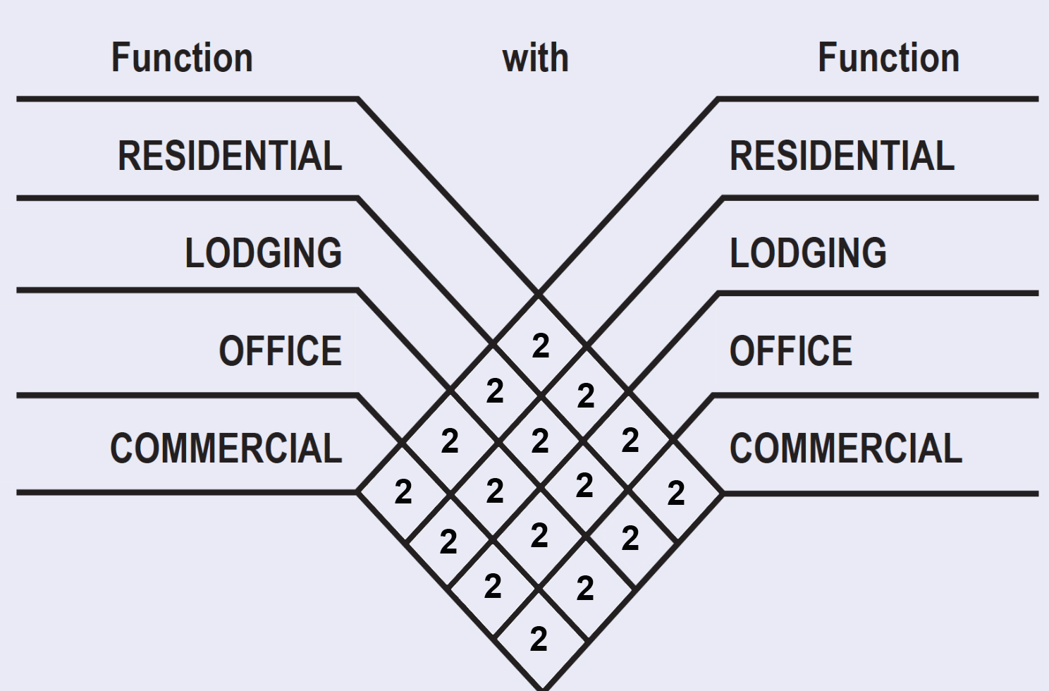
| SHARING FACTOR | The shared Parking Standards Table provides the method for calculating shared parking for buildings with more than one Use type. It refers to the parking requirements that appear in Table 4 and may apply in the aggregate district wide. The parking required for any two Functions on a Lot is calculated by dividing the number of spaces required by the lesser of the two uses by the appropriate factor from this Table and adding the result to the greater use parking requirement. For instance: for a building with a Residential Use requiring 100 spaces and a Commercial Use requiring 20 spaces, the 20 spaces divided by the sharing factor of 2 would reduce the total requirement to 100 plus 10 spaces. For uses not indicated in this chart on a mixed use lot, or within the mixed-use SAP area, a sharing factor of 2 shall be allowed. Additional sharing is allowed by Warrant. | |
| ||
OFF-STREET PARKING STANDARDS | ||||
| ANGLE OF PARKING | ACCESS AISLE WIDTH |
| ||
| ONE WAY TRAFFIC SINGLE LOADED | ONE WAY TRAFFIC DOUBLE LOADED | TWO WAY TRAFFIC DOUBLELOADED | ||
| 90 | 22 ft | 22 ft | 22 ft | |
| 60 | 12.8 ft | 11.8 ft | 19.3 ft | |
| 45 | 10.8 ft | 9.5 ft | 18.5 ft | |
| Parallel | 10 ft | 10 ft | 20 ft | |
| Standard stall: 8.5 ft x 18 ft minimum | ||||
| LOADING BERTH STANDARDS | T5, T6 | NOTES | ||
| RESIDENTIAL* | Berth Size | Loading Berths | Berth Types Residential*: 240 sf = 10 ft x 20 ft x 12 ft * Residential and Lodging loading berths shall be concealed within a building. ** 1 Commercial berth may be substituted by 2 Residential berths A required Commercial loading berth may be substituted be a lesser loading berth, if the size character, and operation of the Use is found to not require the dimensions specified and the required loading berth dimension could not otherwise be provided according to the regulations of this Code. Commercial berths may be shared by retail in same or abutting block. | |
| 420 sf | 1 per first 100 units | |||
| 240 sf | 1 per each additional 100 units or fraction of 100 | |||
| LODGING | Berth Size | Loading Berths | ||
| 420 sf | 1 per 300 | |||
| 240 sf | 1 per 100 | |||
| OFFICE COMMERCIAL** | From 50,000 sf to 500,000 sf of Habitable Space | |||
| Berth Size | Loading Berths | Area | ||
| 420 sf | 1st | 50K sf - 120K sf | ||
| 420 sf | 2nd | 120K sf - 250K sf | ||
ARTICLE 4. TABLE 6 FRONTAGES
|
| |||
|---|---|---|---|---|
a. Common Lawn: a Frontage wherein the Façade is set back substantially from the Frontage Line. The front yard created remains unfenced and is visually continuous with adjacent yards, supporting a common landscape. The Setback can be densely landscaped to buffer from higher speed Thoroughfares. |
|
| ||
b. Porch & Fence: aFrontage wherein the Façade is set back from the Frontage Line with an attached Porch permitted to encroach. A fence at the Frontage Line maintains the demarcation of the yard while not blocking view into the front yard. |
|
| ||
c. Terrace or Light Court: a Frontage wherein the Façade is set back from the Frontage Line by an elevated terrace or a sunken light court. This type buffers residential use from urban sidewalks and removes the private yard from public encroachment. The raised terrace is suitable for outdoor cafes. |
|
| ||
d. Forecourt: a Frontage wherein a portion of the Façade is close to the Frontage Line with a portion set back. The forecourt with a large tree offers visual and environmental variety to the urban Streetscape. The Forecourt may accommodate a vehicular drop off. |
|
| ||
e. Stoop: a Frontage wherein the Façade is aligned close to the Frontage Line with the first Story elevated from the sidewalk sufficiently to secure privacy for the windows. The entrance is usually an exterior stair and landing. This type is recommended for ground-floor Residential Use. |
|
| ||
f. Shopfront: a Frontage wherein the Façade is aligned close to the Frontage Line with the Building entrance at sidewalk grade. This type is conventional for retail Use. It has substantial glazing at the sidewalk level and an Awning that may overhang the sidewalk. |
|
| ||
g. Gallery: a Frontage wherein the Façade is aligned close to the Frontage Line with an attached cantilevered or a lightweight colonnade overlapping the sidewalk. This type is conventional for retail Use. Allowed by SAP Permit. See 5.4.2, 5.5.2 and 5.6.2 of this Miami Design District Retail Street Special Area Plan for additional regulations. |
|
| ||
h. Arcade: a Frontage wherein the Façade includes a colonnade that overlaps the sidewalk, while the Façade at sidewalk level remains at the Frontage Line. This type is conventional for retail Use. Arcades may contain programmable space or arcades or balconies above them corresponding with the width of the covered area. Allowed by SAP Permit. See 5.4.2, 5.5.2 and 5.6.2 of this Miami Design District Retail Street Special Area Plan for additional regulations. |
|
| ||
i. Cantilever: a Frontage wherein the Facade includes a cantilevered section of a Building which overlaps the sidewalk, with the Facades at sidewalk level remaining at the Frontage or Front Setback Line. Cantilevers may contain programmable space or arcades or balconies above them corresponding with the width of the covered area or may be designed as architectural canopies. A variation may have a light support. Allowed by SAP Permit. See 5.4.2, 5.5.2 and 5.6.2 of this Miami Design District Retail Street Special Area Plan for additional regulations. |  |  | ||
j. Porte-Cochère: A specific Frontage type where the driveway goes beneath habitable space into a protected vehicular drop off and pedestrian entry area. A porte-cochère provides an opening through a continuous Building facade. Driveway width and separation rules for each Transect Zone shall apply. |  |  | ||


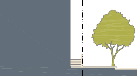


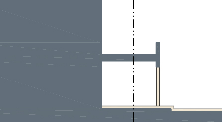

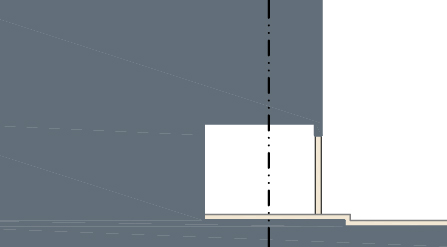
ARTICLE 4. TABLE 8 DEFINITIONS ILLUSTRATED
| a. THOROUGHFARE & FRONTAGES | |||
|---|---|---|---|
| |||
| b. TURNING RADIUS | c. BUILDING DISPOSITION | ||
|
| ||
| d. LOT LAYERS | e. FRONTAGE & LOT LINES | ||
|
| ||
| e. SETBACK DESIGNATIONS | f. VISIBILITY TRIANGLE | ||
|
| ||
*ESA - Established Setback Area. See Miami 21 Appendix F Article 1 - Definitions | |||
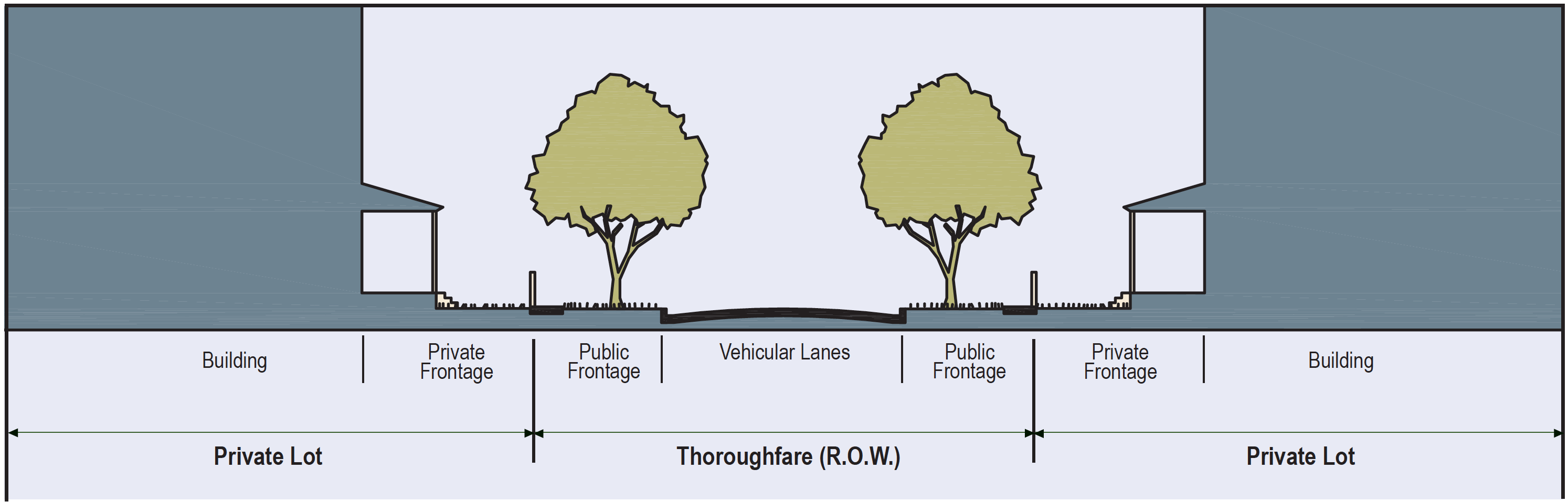
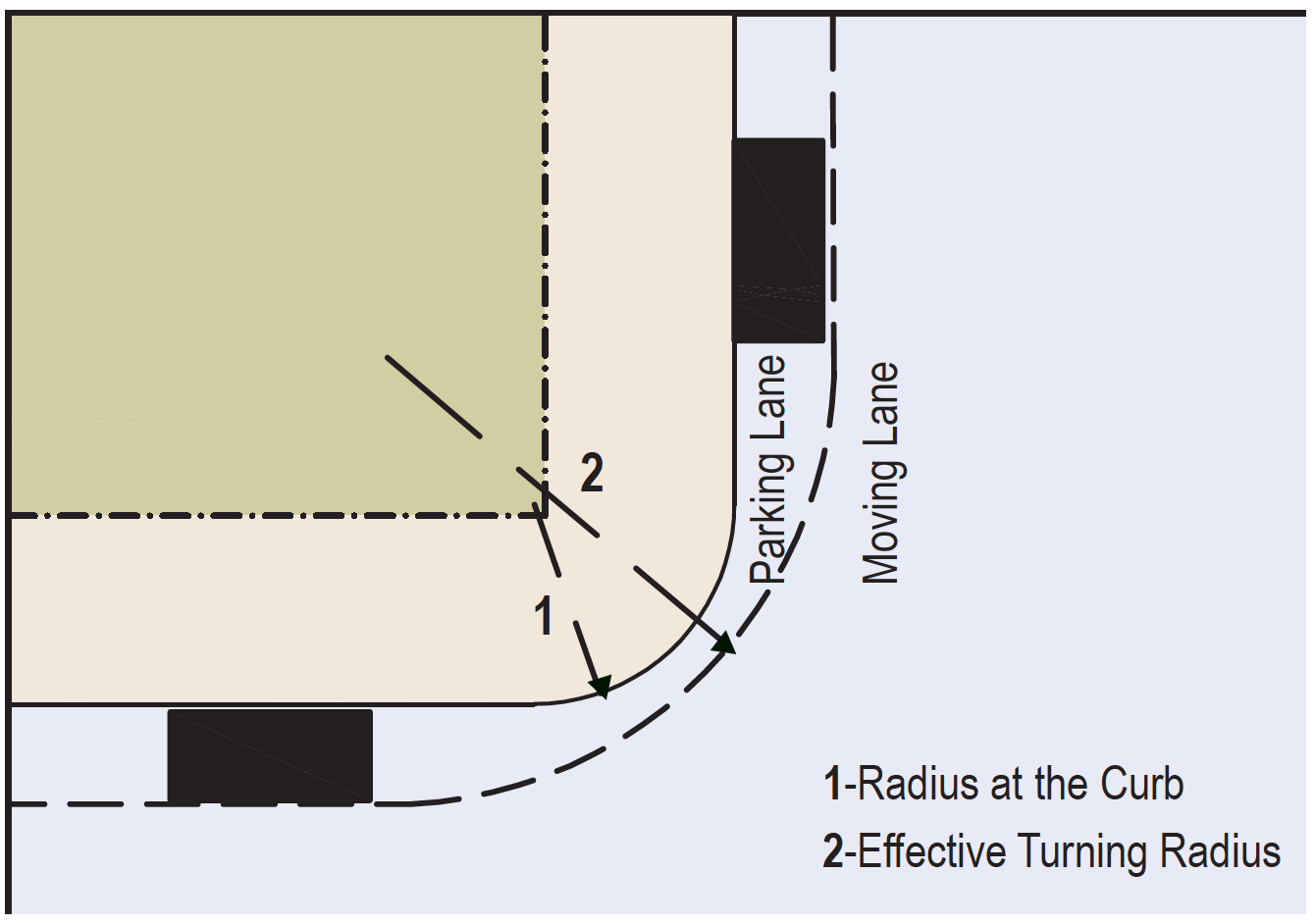
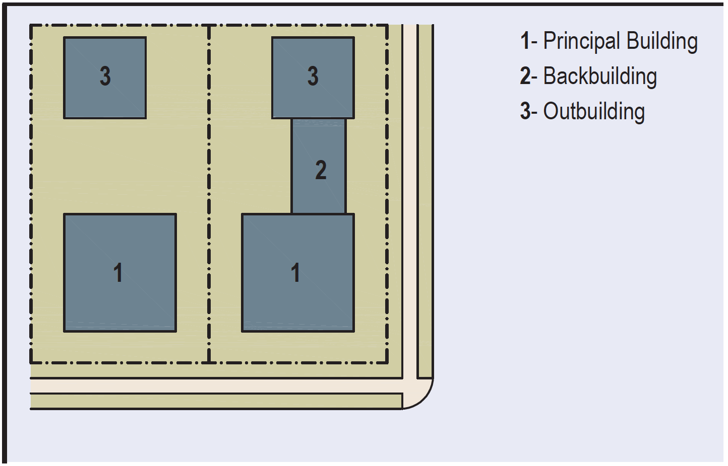
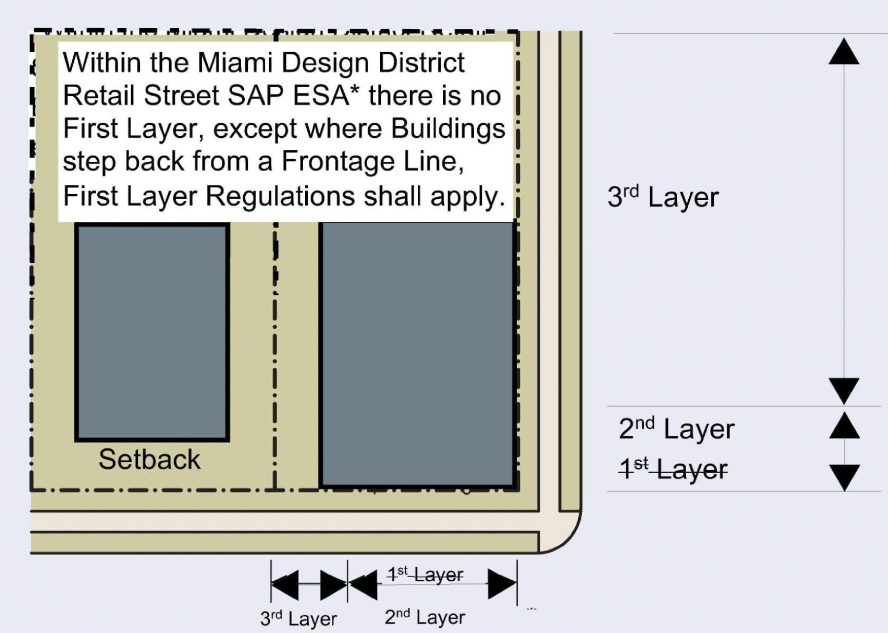
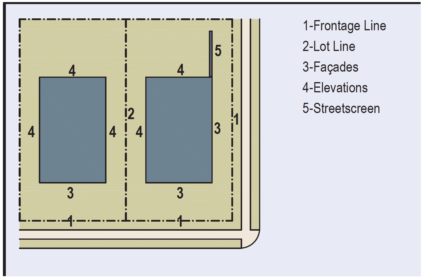
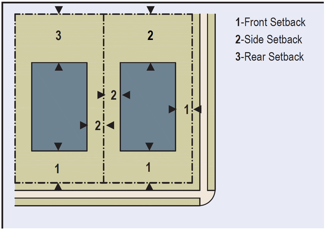
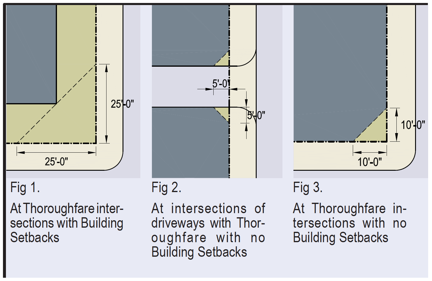
ILLUSTRATION 5.4 URBAN CENTER TRANSECT ZONES (T4)
(The table below can also be found in Ord.14244 14/12/2023 PDF here)
| BUILDING DISPOSITION LOT OCCUPATION | 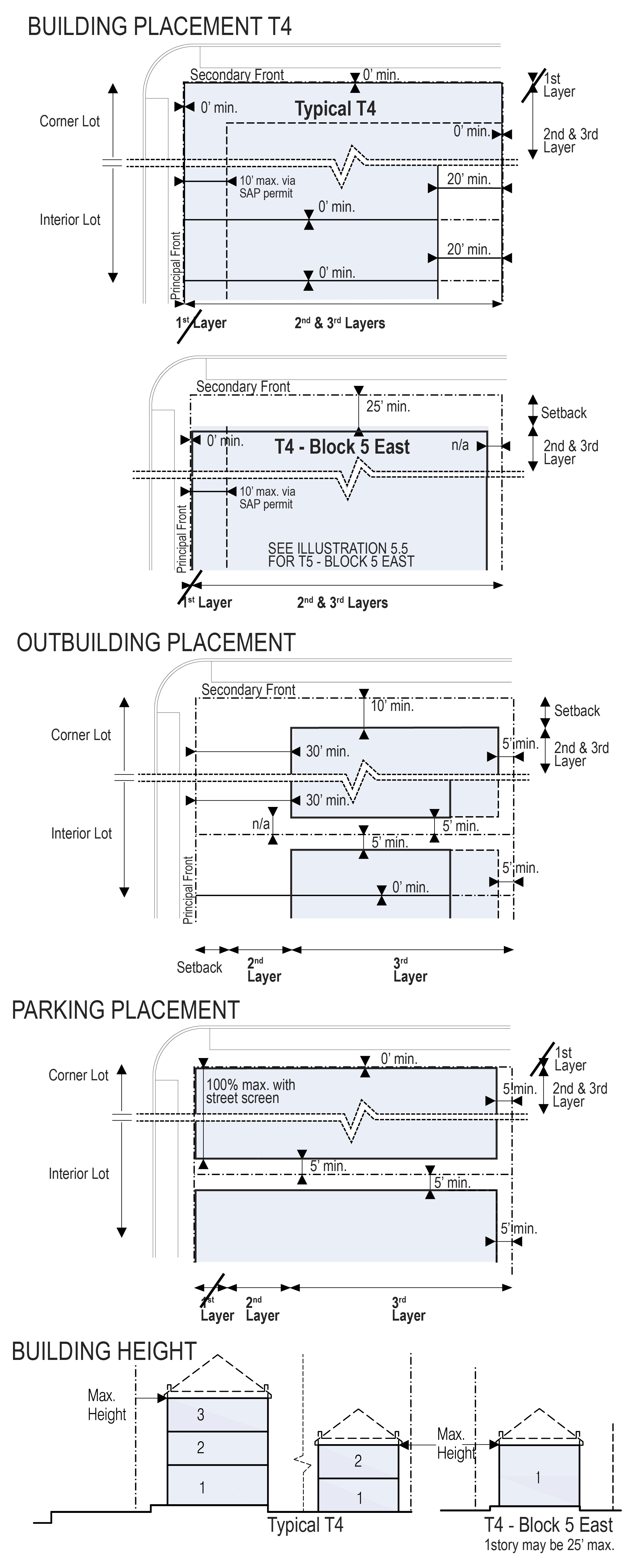 | |
| a. Lot Area - if rear vehicular access | 5,000 s.f. min. 1,400 s.f. min. | |
| b. Lot Width - if rear vehicular access | 50 ft. min. 16 ft. min. | |
| c. Lot Coverage | 93.5 % SAP aggregate, except Block 5 East. See 5.4.1.(b)1 | |
| d. Floor Lot Ratio (FLR) | N/A | |
| e. Frontage at front Setback | 50% min. or as permitted in 5.4.1.(f) | |
| f. Open Space Requirements | 6.5 % min.SAP aggregate, except Block 5 East2 | |
| g. Density | 36 du/acre max. | |
| BUILDING SETBACK3 | ||
| a. Principal Front | Est. Setback 0 ft or 10 ft max. via SAP Permit | |
| b. Secondary Front | Est. Setback or 10 ft max.via SAP Permit, except along NE 43rd Street for Block 5 East 25 ft or 50 ft min.4 See 5.4.1.(e) | |
| c. Side | 0 ft. min.5 n/a for Block 5 East | |
| d. Rear | 20 ft. min. n/a for Block 5 East | |
| OUTBUILDING SETBACK (Note: Outbuilding Setbacks are not applicable to Block 5 East) | ||
Principal Front | 30 ft. min. | |
| Secondary Front | 10 ft. min. | |
| Side | 0 ft. min.6 | |
| Rear | 5 ft. min. | |
| BUILDING CONFIGURATION FRONTAGE | ||
| a. Common Lawn | permitted | |
| b. Porch & Fence | prohibited | |
| c. Terrace or L.C. | permitted | |
| d. Forecourt | permitted | |
| e. Stoop | permitted | |
| f. Shopfront | permitted (T4 L & O only) | |
| g. Gallery | permitted* | |
| h. Arcade | permitted* | |
| i. Cantilever | permitted* | |
| j. Porte-Cochère | permitted* | |
| *Habitable Space allowed above via SAP Permit | ||
| BUILDING HEIGHT | ||
| a. Principal Building | 3 Stories and 40 ft. max. except 1 Story and 25 ft. max. for Block 5 East | |
| b. Outbuilding | 2 Stories max. n/a for Block 5 East | |
1 Block 5 East shall meet its Lot Coverage requirements independently.
2 For further information regarding Open Space, please see Section (15)(b) of the MDDA Development Agreement except: for Block 5 East, see Section (13) of the Helm Development Agreement; and for applicable parcels in Block 5, See Section (13) of the Flagler Development Agreement.
3 Please see Article 4 Table 8 regarding no First Layer in the SAP Area.
4 Block 5 East Secondary Frontage along NE 43rd Street shall be Setback 25 ft min. for 150 ft from NE 2nd Avenue and thereafter 50 ft min. See 5.4.1.(e).
5 Where an adjacent Building has a side Setback, then new Building shall match said Setback up to 5 ft.
6 Where an adjacent Building has a side Setback, then new Building shall match said Setback up to 5 ft.
ILLUSTRATION 5.5 URBAN CENTER TRANSECT ZONES (T5)
(The table below can also be found in Ord.14244 14/12/2023 PDF here)
| BUILDING DISPOSITION LOT OCCUPATION1 | 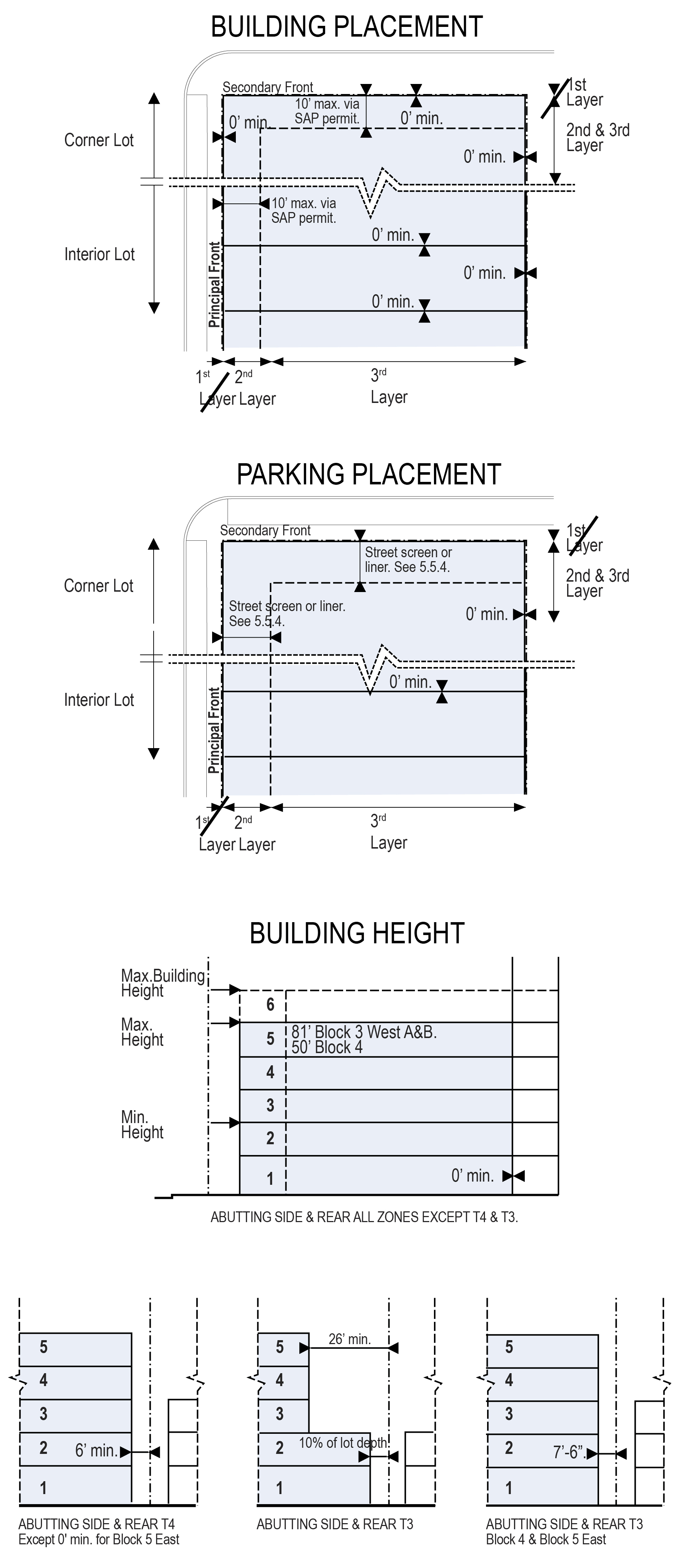 | |
| a. Lot Area - With rear vehicular access | 5,000 s.f. min. 1,200 s.f. min. | |
| b. Lot Width - With rear vehicular access | 50 ft. min. 16 ft. min. | |
| c. Lot Coverage | 93.5 % SAP aggregate, except Block 5 East and Block 3 West B. See 5.5.1.(b)2 | |
| d. Floor Lot Ratio (FLR) | N/A | |
| e. Frontage at front Setback | 60% min. or as permitted in 5.5.1.(e). | |
| f. Open Space Requirements | 6.5 % SAP aggregate, except Block 5 East and Block 3 West B.3 | |
| g. Density | 65 du/acre max. | |
BUILDING SETBACK4 | ||
| a. Principal Front | Est. Setback 0 ft. or 10 ft. max. via SAP Permit | |
| b. Secondary Front | Est. Setback 0 ft. or 10 ft. max. via SAP Permit, except 10' min. 1st Story; 15' min. 2nd Story Block 4 | |
| c. Side | 0 ft. min. | |
| d. Rear | 0 ft. min. | |
| e. Abutting Side or Rear T4 | 6 ft. min., except 0' min. for Block 5 East | |
| Abutting Side or Rear T3 | 10% of Lot depth min., 1st through 2nd Story 26 ft. min. above 2nd Story, except 7.5 ft. min. all Stories in Block 4 & Block 5 East | |
BUILDING CONFIGURATION FRONTAGE | ||
| a. Common Lawn | prohibited | |
| b. Porch & Fence | prohibited | |
| c. Terrace or L.C. | prohibited | |
| d. Forecourt | permitted | |
| e. Stoop | permitted | |
| f. Shopfront | permitted (T5 L & O only) | |
| g. Gallery | permitted* | |
| h. Arcade | permitted* | |
| i. Cantilever | permitted* | |
| j. Porte-Cochère | permitted* | |
| *Habitable Space allowed above via SAP Permit | ||
BUILDING HEIGHT | ||
| a. Min. Height | 2 Stories | |
| b. Max. Height, except below: | 5 stories unless specified in 5.5.2.(g) | |
| Block 4 Block 3 West A & B Block 5 East | 50 ft. 81 ft. Varies. 81 ft. or less. See 5.5.2 (g) | |
| c. Max. Building Height | 1 Story Abutting D1 | |
1 A Cross-Block Pedestrian Passage shall not be required for Blocks 3 West A and B, Block 4 and Block 5 East. See 5.5.1.(h)
2 Block 5 East shall meet its Lot Coverage requirement independently. Lot Coverage calculations for Block 3 West B shall be calculated independent of the aggregate calculation for new Buildings within the SAP Area, except may be calculated in aggregate with Block 2 West B and Block 2 West C.
3 For further information regarding Open Space, please see Section (15)(b) of the MDDA Development Agreement except: for Block 5 East please see Section (13) of the Helm Development Agreement; and for Block 3 West B see Section (13) of the RFD Development Agreement.
4 Please see Article 4 Table 8 regarding no First Layer in the SAP Area.
ILLUSTRATION 5.6 URBAN CORE TRANSECT ZONES (T6-8)
(The table below can also be found in Ord.14244 14/12/2023 PDF here)
| BUILDING DISPOSITION LOT OCCUPATION | 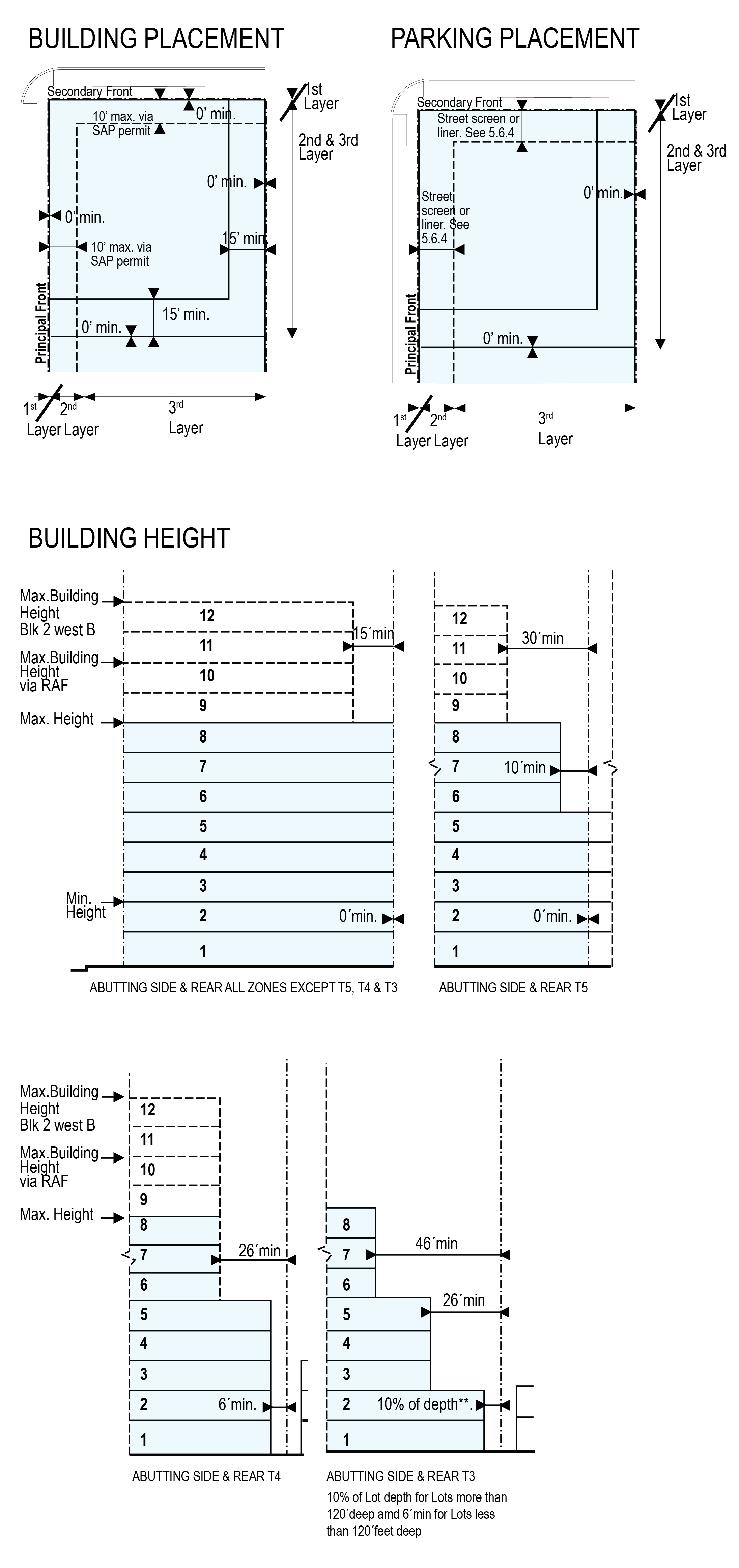 | |
| a. Lot Area | 5,000 s.f. min. | |
| b. Lot Width | 50 ft. min. | |
| c. Lot Coverage | ||
| -1-8 Stories | 93.5 % SAP aggregate, except Block 2 West B1. See 5.6.1.(a) | |
| - Above 8th Story | Residential & Lodging: 15,000 s.f. floorplate max. Office & Commercial: n/a | |
| d. Floor Lot Ratio (FLR)6 | 5 / 7 via RAF2 or for Block 2 West B additional Public Benefit via 3.14 of Miami21 | |
| e. Frontage at front Setback | 60% min. or as permitted in 5.6.1.(d) | |
| f. Open Space Requirements | 6.5% min. SAP aggregate, except Block 2 West B.3 | |
| g. Density6 | 150 du/acre max. or 300 du/ac max via RAD4 | |
BUILDING SETBACK5 | ||
| a. Principal Front | Est. Setback 0 ft. or 10 ft. via SAP Permit. 0' above 8th story pursuant to ESA | |
| b. Secondary Front | Same as Principal Front | |
| c. Side | 0 ft. min.; 15 ft. min. above 8th Story | |
| d. Rear | 0 ft. min.; 15 ft. min. above 8th Story | |
| e. Abutting Side or Rear T5 | 0 ft. min. 1st through 5th Story 10 ft. min. 6th through 8th Story 30 ft. min. above 8th Story | |
| Abutting Side or Rear T4 | 6 ft. min. 1st through 5th Story 26 ft. min. above 5th Story | |
| Abutting Side or Rear T3 | 10% of Lot depth min. 1st through 2nd Story 26 ft. min. 3rd through 5th Story 46 ft. min. above 5th Story | |
BUILDING CONFIGURATION FRONTAGE | ||
| a. Common Lawn | prohibited | |
| b. Porch & Fence | prohibited | |
| c. Terrace or L.C. | prohibited | |
| d. Forecourt | permitted | |
| e. Stoop | permitted | |
| f. Shopfront | permitted (T6-8 L & O) | |
| g. Gallery | permitted* | |
| h. Arcade | permitted* | |
| i. Cantilever | permitted* | |
| j. Porte-Cochère | permitted* | |
| * habitable space above via SAP Permit | ||
BUILDING HEIGHT | ||
| a. Min. Height | 2 Stories | |
| b. Max. Height | 8 Stories | |
| c. Max. Building Height | 10 Stories via RAF, except 12 Stories Block 2 West B | |
1 Lot Coverage calculations for Block 2 West B shall be calculated independent of the aggregate calculation for new Buildings within the SAP Area, except may be calculated in aggregate with Block 2 West C and Block 3 West B.
2 "RAF" Remaining Aggregate FLR. See Article 1, Definitions.
3 For further information regarding Open Space, please see Section (15)(b) of the MDDA Development Agreement and for Block 2 West B see Section (13) of the RFD Development Agreement.
4 "RAD" Remaining Aggregate Density. See Article 1, Definitions.
5 Please see Article 4 Table 8 regarding no First Layer in the SAP Area.
6 Block 2 West B is designated T6-8 Transect Zone; however, the permissible Floor Area shall be limited as if it was a T5 Transect Zone and Density shall be calculated as 65 DU/ac. The permissible Floor Area shall be calculated in accordance with the T5 standards in Illustration 5.5 of Miami 21.
ILLUSTRATION 5.6 URBAN CORE TRANSECT ZONES (T6-12)
(The table below can also be found in Ord.14244 14/12/2023 PDF here)
| BUILDING DISPOSITION LOT OCCUPATION1 |  | |||||
| a. Lot Area | 5,000 s.f. min. | |||||
| b. Lot Width | 50 ft. min. | |||||
| c. Lot Coverage | ||||||
| -1-8 Stories | 93.5 % SAP aggregate, except Block 2 West C2 | |||||
| - Above 8th Story | Res.& Lodging: 15,000 s.f. Floorplate max., except for Signature Towers. Off & Comm: n/a | |||||
| d. Floor Lot Ratio (FLR) | 8 /11 via RAF3 or for Block 2 West C additional Public Benefit via Sec. 3.14 of Miami21, except 10.4 max. for Gateway Sites. | |||||
| e. Frontage at front Setback | 60% min. or as permitted in 5.6.1.(d) | |||||
| f. Open Space Requirements | 6.5% min. SAP agg., except Block 2 West C4 | |||||
| g. Density | 150 du/ac5 or 300 du/ac via RAD3 | |||||
BUILDING SETBACK (see Art 4 Table 8, no First Layer) | ||||||
| a. Principal Front | Est. Setback 0 ft. or 10 ft. via SAP Permit. 0 ft. above 8th story pursuant to ESA | |||||
| b. Secondary Front | Same as Principal Front | |||||
| c. Side | 0 ft. min.; 15 ft. min. above 8th Story | |||||
| d. Rear | 0 ft. min.; 30 ft. min. above 8th Story6 | |||||
| e. Abutting Side or Rear T5 | 0 ft. min. 1st through 5th Story 10 ft. min. 6th through 8th Story 30 ft. min. above 8th Story except, 10' min. Block 1 West, Block 2 West A & C | |||||
| Abutting Side or Rear T4 | 6 ft. min. 1st through 5th Story | |||||
| Abutting Side or Rear T3 | 10% of Lot depth min. 1st through 2nd Story 26 ft. min. 3rd through 5th Story 46 ft. min. above 5th Story | |||||
BUILDING CONFIGURATION FRONTAGE | ||||||
| a. Common Lawn | prohibited | |||||
| b. Porch & Fence | prohibited | |||||
| c. Terrace or L.C. | prohibited | |||||
| d. Forecourt | permitted | |||||
| e. Stoop | permitted | |||||
| f. Shopfront | permitted (T6-12 L & O only) | |||||
| g. Gallery | permitted* | |||||
| h. Arcade | permitted* | |||||
| i. Cantilever | permitted* | |||||
| j. Porte-Cochère | permitted* | |||||
| * habitable space above via SAP Permit | ||||||
BUILDING HEIGHT | ||||||
| a. Min. Height | 2 Stories | |||||
| b. Max. Height | 12 Stories | |||||
| c. Max. Building Height7 | 20 stories via RAF 291 ft. Block 1A, Block 2 West C 36 Stories Block 1 East East via Bonus Height | |||||
1 A Cross-Block Pedestrian Passage shall not be required for Block 1 West or Block 1 East East.
2 Lot Coverage calculations for Block 2 West C shall be calculated independent of the aggregate calculation for new Buildings within the SAP Area, except may be calculated in aggregate with Block 2 West B and Block 3 West B. See 5.6.1.(a).
3 "RAF" Remaining Aggregate FLR. "RAD" Remaining Aggregate Density. See Article 1, Definitions.
4 For further information regarding Open Space, please see Section (15)(b) of the MDDA Development Agreement and for Block 2 West C see Section (13) of the RFD Development Agreement.
5 Gateway Sites shall have a maximum Density of 150 du/ac.
6 For Block 2 West C, Rear and Side Setbacks shall be 15' min. above the 8th Story.
7 For Block 2 West A, 12 Stories max. north of midblock and 14 Stories max. south of midblock.
7.1.2 Permits
The permits that may be necessary to develop property within the Miami Design District Retail Street SAP area include the following: Warrant; Waiver; Exception; Variance; SAP Permit; and amendment to the Miami Design District Retail Street SAP. The permits, with the exception of the SAP Permit, are illustrated in Article 7, Diagram 14. In addition, certain approvals may be necessary to confirm that uses are permitted under the Code, these include zoning approval (by right), certificate of use, planning determination, or zoning interpretation. Permits issued in error shall convey no rights to any party. The Zoning Administrator shall require corrections to be made unless construction has commenced on that portion of the construction that was permitted in error.
9.5 MINIMUM STANDARDS
The following standards shall be considered minimum requirements unless otherwise indicated:
2.1.1. INTENT
The intent of the Miami Design District Retail Street Special Area Plan ("SAP" or "Miami Design District SAP") is to guide the design, construction and management of a retail pedestrian street and its surrounding city streets in the Design District to ensure a high quality, mixed use, pedestrian experience. The control of Building location, massing, and surface is intended to produce public space that is safe, comfortable and interesting for pedestrians and attractive to high-end retail tenants. Pedestrian mobility is to be improved by an enhanced Public Right-of-Way Streetscape and by the addition of a four block long Pedestrian Passage.
The public space of the Pedestrian Passage is of a scale that is intimate and episodic. The quantity and materials of shared elements in the public spaces, such as pavement, signs and lighting are intended to be minimized and recessive, as the primary experience should be that of the highly individualistic retail stores. The Building Facade lines of the Miami Design District Retail Street SAP are drawn to support the continuity of the existing Design District street wall, to form the sequential character of the pedestrian street experience, and to give store tenants appropriate space distribution and visibility.
This document precedes the final development program, architectural design and detailing, and infrastructure engineering, and it is expected that adjustments to the development program, architectural design and detailing, and infrastructure engineering may be necessary during implementation phases of design development and construction documents. Adjacent and non-adjacent parcels within the SAP Area which have unutilized density or unutilized FLR, located within the T6 Urban Core transect zone ("T6 Properties") may transfer such Remaining Aggregate Density or Remaining Aggregate FLR to other T6 Properties within the SAP Area, provided however that each individual project on those T6 Properties must comply with the limits imposed by the SAP Regulating Plan and the Comprehensive Plan. Notwithstanding the forgoing, density and intensity shall be counted on an aggregate basis for all T6 Properties located within the SAP; such that the total aggregated density and intensity throughout the T6 Properties shall not surpass the aggregated as-of-right maximum (i.e. base) density and intensity permitted in the underlying T6 Properties. Aggregated density and intensity, as well as the Remaining Aggregate Density and Remaining Aggregate FLR will be tracked via an aggregated rights Tracking Sheet and reviewed annually as part of the Annual Review process, as indicated in the MDDA Development Agreement and RFD Development Agreement.
The SAP is based on the Miami 21 Zoning Code, as amended through April 2012, and shall serve to supplement the code. Where standards set forth herein conflict with standards set forth in the code, the standards in this SAP shall govern, including but not limited to Section 6.5 Sign Standards, which supersedes the Sign Regulations in Article 10 of Miami 21. Where the standards in the SAP are silent, the underlying Miami 21 zoning code requirements shall govern. By virtue of the adoption of the Miami Design District Retail Street SAP, and any subsequent amendments thereto, all provisions of the Miami 21 Zoning Code requiring enactment or authorization by Special Area Plan pursuant to and identified in Section 3.9, unless modified in the SAP, shall be deemed duly enacted or authorized.
The Miami Design District Retail Street SAP shall not constitute a precedent for the balance of the City of Miami. The alternate standards of this SAP should be considered unique with regard to the large aggregation of property under multiple ownership committed to an integrated development plan, as well as its unified design and management that will enable and ensure a coherent, high quality, and sustainable result.
3.3.6
For new Buildings in Established Setbacks Areas, the Established Setback may be maintained as identified on page A1.7 of the Concept Book . Galleries, Cantilevers and Arcades may be permitted within Established Setback Areas and may be permitted to encroach into the Public Right-of-Way by SAP Permit and upon review by UDRB and with the approval of the Director of Public Works and Planning Director. Habitable Space above the Public Right-Of-Way shall be included in the development capacity of the subject lot and included towards the overall development capacity approved within this SAP.
Established Setback Areas include:
c. Design District
1. Boundary: The Established Setback for the Miami Design District Retail Street SAP shall be as identified on page A1.7 of the Concept Book. and applicable throughout the SAP area. Established Setbacks shall apply for the entire Height of the Building.
- Frontage Setback: Zero (0’) feet
3.5.2
A Story is a Habitable level within a Building of a maximum fourteen (14) feet in Height from finished floor to finished floor. Basements are not considered Stories for the purposes of determining Building Height. A ground level Story may exceed this limit up to a total height of twenty-five (25) feet and a top level Story in the T5, T6 Transect Zones may exceed this limit up to a total height of twenty-eight (28) feet and count as one (1) Story, if the Building Height does not exceed the Maximum Building Height including all applicable bonuses allowed by the transect at fourteen (14) feet per floor and twenty-five (25) feet at the ground level. A single floor level exceeding fourteen (14) feet, or twenty-five (25) feet at ground level , shall be counted as two (2) Stories; except for T6-12 where a single floor exceeding fourteen (14) feet may count as one (1) Story if the Building Height does not exceed the Maximum Building Height, including by RAF or all applicable bonuses, allowed by the specific block identified in the illustrations in Article 5. Where the first two Stories are retail or hotel lobby, their total combined Height shall not exceed thirty-nine (39) feet and the first floor shall be a minimum of fourteen (14) feet in Height. Mezzanines and other interstitial spaces that may be accessed for storage, repairs and other service functions shall not count as a Story so long as the maximum height does not exceed fourteen (14) feet and may not exceed thirty-three percent (33%) of the Habitable Space Floor Area.
3.5.3
Except as specifically provided herein, the Height limitations of this Code shall not apply to any roof Structures for housing elevators, bathrooms, stairways, tanks, ventilating fans, solar energy collectors, or similar equipment required to operate and maintain the Building (provided that such Structures shall not cover more than twenty percent (20%) of roof area for T4 and T5); nor to church spires, steeples, belfries, monuments, water towers, flagpoles, vents, or similar Structures, which may be allowed to exceed the maximum Height by SAP Permit; nor to fire or parapet walls, which shall not extend more than five (5) feet above the maximum Height in T4 and T5 and ten (10) feet in T6.
3.6.1 Off-street Parking Standards
Off-street Parking requirements for the individual Transect Zones shall be as set forth in Article 4, Table 4 of the Miami Design District Retail Street SAP. Where required Off-street Parking is based on square footage of Use, the calculation shall only include Habitable Rooms and Habitable Space occupied by such Use. Parking and Loading Spaces shall not be required for Ancillary Uses, including Ancillary Retail Storage. With the exception of Block 5 East, Off-street Parking requirements within the Miami Design District Retail Street SAP area may be calculated and provided for in aggregate for new Buildings. Existing Buildings as identified on Sheet A2.3 of the Concept Book, shall not be required to provide parking, if densities and intensities do not increase from existing uses from the adopted date of approved Miami Design District Retail Street SAP, as amended. If density and intensities change then applicable parking requirements shall apply. All new development shall be subject to parking requirements within Miami 21, as modified by the Miami Design District Retail Street SAP.
- Off-street Parking dimensions and Shared Parking (mixed-use) reduction table shall be as set forth in Article 4, Table 5 of the Miami Design District Retail Street SAP.
- Required Parking for Adaptive Reuses may be reduced or exempted by SAP Permit for properties located in a Community Redevelopment Area, or in areas where a Parking Trust Fund has been established, or for historic sites and contributing Structures within designated historic districts.
- Parking reductions shall not be cumulative except in T4, T5 and T6. Parking reductions shall not exceed fifty percent (50%) of the total Off-street Parking required, except for Residential components of projects within one thousand (1,000) feet of Metrorail or Metromover stations.
- Parking requirements may be satisfied in the Miami Design District Retail Street SAP area by making payment into the Design District Parking Improvement Trust Fund pursuant to Section 35, Article V of the City Code; such payments may be used to satisfy certain parking requirements in full or in part for particular development programs in the Miami Design District Retail Street SAP area.
- Porte-Cochères where one valet drop off area services greater than 275 dwelling units shall provide direct access to temporary valet vehicular storage without crossing into the public frontage, except via SAP Permit.
3.6.2 Off-street Parking Driveway Standards [RESERVED]
3.6.3 Additional Off-street Parking Regulations
General performance standards for Off-street Parking facilities:
- Parking shall be implemented so as to provide safe and convenient access to and from public Thoroughfares which include movement lanes and Public Frontages.
- Vehicular access through single family residential properties for nonresidential Uses shall be prohibited.
- Off-street Parking spaces shall be located with sufficient room for safe and convenient parking without infringing on any public Thoroughfare or sidewalk.
- Off-street Parking spaces whose locations require that cars back into movement lanes shall only be permissible in T4 zones. Backing into Alleys shall be permissible in all Transect Zones.
- Off-street Parking or loading area shall not be used for the sale, repair, or dismantling of any vehicle or equipment, or for storage of materials or supplies.
- Parking or storage of commercial trucks, buses, vans, sign trailers; trailers or semi-trailers for freight, cargo; or the like shall not be permitted in any T4, T5-R or T6-R Zone.
- Inoperable vehicles shall be stored only in storage facilities or other approved places where they are completely concealed from public view.
- Except in connection with permitted active continuing construction on the premises, construction equipment such as earth moving machines, excavators, cranes, and the like are not permitted.
- All Off-street Parking shall comply with applicable regulations related to lighting, paving, and drainage including the Miami-Dade County Code and the Florida Building Code.
- Specific areas may be set aside for Tandem Parking. Tandem Parking in all Transect Zones, may be used by both a valet parking operator or for residential self-parking. Each Tandem Parking space for residential self-parking shall serve a single residential unit.
- Parking facilities on adjoining Lots may share access points, driveways and parking subject to a recorded covenant running with the property on which the facilities are located.
- Where Lots are Abutting, underground parking may extend to Abutting blocks and Lots, including under Thoroughfares., as described in the Development Agreements or as otherwise authorized by the City
3.6.4 Calculation of Off-street Parking requirements related to number of seats.
Where parking requirements relate to number of seats and seating is in the form of undivided pews, benches, or the like, twenty (20) lineal inches shall be construed to be equal to one (1) seat. Where Parking requirements relate to movable seating in auditoriums and other assembly rooms, ten (10) square feet of Floor Area shall be construed to be equal to one (1) seat except where otherwise specified. Net floor area shall be the actual area occupied by seating and related aisles, and shall not include accessory unoccupied areas or the thickness of walls.
3.6.5 Valet Parking
Off-street Parking facilities maintained with valet parking shall be allowed generally, provided that the minimum Off-street Parking requirements of this Code are satisfied and that an attendant shall remain on duty during business hours or as long as the Principal Building is occupied.
Valet parking stations shall respond to demand within the Miami Design District Retail Street SAP area and multiple valet stations may be provided on each block when such stations are operated under a unified management scheme. Each valet station shall be permitted subject to review by the Miami Parking Authority (MPA) to ensure that the proposed locations will not adversely affect the flow of traffic on the adjoining Thoroughfare.
3.6.9 Loading Requirements
Off-street vehicular loading shall be required in accordance with the standards set forth in Article 4, Table 5 of the Miami Design District Retail Street SAP. Service and loading vehicles servicing properties located within the Miami Design District Retail Street SAP area may gain access to such off-street loading area in order to service the property by utilizing no more than three (3) on-street maneuvers.
- Loading Standards. On-street loading shall be allowed in areas designated by signage and for limited intervals during specified hours.
- Retail/Commercial Loading. On-street loading areas intended to service storefront retail and retail locations along the Pedestrian Passage shall be permitted within specifically designated zones. Loading within such designated zones shall not exceed 20 minutes. Such loading activity shall occur only between the hours of 6 a.m. and 10 a.m.
- Express Parcel Delivery. On-street loading for express parcel delivery shall be allowed in specifically designated zones. Loading within such designated zones shall not exceed 15 minutes and shall occur only between the hours of 8 a.m. and 6 p.m.
- Required decorative screening. Off Street Loading shall be screened by decorative walls or gates as described in Article 5, which shall be kept closed when the loading entry is not in use.
3.6.10 Bicycle Parking Requirements
- Bicycle parking shall be provided in aggregate for all new, Buildings in all T4, T5, and T6 zones, as shown in Article 4, Table 4 of the Miami Design District Retail Street SAP. The requirement set forth herein shall not apply to any existing and Adaptive Use Buildings.
- Block 5 East. Notwithstanding the foregoing, bicycle parking for any new Building within Block 5 East shall be calculated and provided independently of the aggregate calculation for bicycle parking on the balance of the Blocks comprising the Miami Design District Retail Street SAP.
- After the first fifty (50) required bicycle spaces are provided within the Miami Design District Retail Street SAP area, additional required spaces may be reduced by one-half.
- Required bicycle parking shall meet the following standards:
- Required bicycle parking facilities may be located within the project site, adjacent to multiple Buildings, or in a shared bicycle parking facility located within the Miami Design District Retail Street SAP area and subject to all the conditions for shared bicycle parking facilities below:
- Required bicycle parking for Buildings within the Miami Design District Retail Street SAP area may be satisfied in the aggregate and will be tracked via an aggregated rights Tracking Sheet, that will be submitted as part of the building permit application for each project and reviewed annually as part of the Annual Review process.
- Shared bicycle parking facilities may be located anywhere within the Miami Design District Retail Street SAP area.
- The minimum number of required bicycle parking is satisfied by all Buildings using the shared facility.
- Required bicycle parking facilities may be located within the project site, adjacent to multiple Buildings, or in a shared bicycle parking facility located within the Miami Design District Retail Street SAP area and subject to all the conditions for shared bicycle parking facilities below:
- Within the Miami Design District Retail Street SAP area, bicycle parking requirements may be satisfied by providing bicycle racks within the Sidewalk or on-street bicycle corrals within an on-street parking space. Said racks or bicycle corrals shall be available for use by the public at no cost. Locations may be chosen to support Transit Oriented Development along Priority Corridors.
- Bicycle parking requirements shall be calculated in aggregate, prior to automobile parking reductions for the off-street parking requirements for the Miami Design District Retail Street SAP area.
3.9.1 General
Unless a Building is specifically approved as part of the Special Area Plan, any Building equal to or greater than 200,000 sq. ft. of Floor Area shall be reviewed by the Planning Director, after referral to and recommendation from the CRC for conformance to the Plan, prior to issuance of the Building Permit.
3.13.1 General
a. Landscape requirements are as required in Article 9 of the Miami Design District Retail Street SAP, this Code, and the City of Miami Tree Protection regulations of Chapter 17 of the City Code, as amended by the Development Agreements. Where the Miami Design District Retail Street SAP and the Miami 21 code are more restrictive than the Tree Protection regulations as amended in the Development Agreements, the Miami Design District Retail Street SAP and the Miami 21 code shall apply.
NOTE: All new Buildings in excess of 50,000 sq. ft. of Floor Area within the Miami Design District Retail Street SAP shall conform to the sustainability requirements set forth in Miami 21.
3.14.1 The Miami Design District SAP has provided the following public benefits:
- Construction of the Pedestrian Passage (i.e. Paseo Ponti and Jade Alley) from Palm Court to Paradise Plaza.
- Activation of Palm Court and Paradise Plaza as publicly accessible civic spaces.
- Improvements to the pedestrian realm through enhanced public right-of-way investments, which include, paving, utilities, drainage, landscaping, pavers, site amenities, and street lighting throughout the SAP.
- Public art investments throughout the SAP.
- Artistic garage facades throughout the SAP.
- Architectural facades throughout the SAP .
- Marketing, operating and curating the district as a premier cultural destination in the City of Miami.
- Contributions towards the Institute of Contemporary Art, Miami ("ICA"), including the donation of the underlying lots.
- Payment of maintenance for the public right-of-way investments and all public benefit investments throughout the SAP.
- FEC Right of Way Improvements, in the event one or more of the SAP parcels fronting the Florida East Coast Railway right-of-way (“FEC Right-of-Way”) obtains a building permit for demolition or redevelopment, as described further in the MDDA Development Agreement.
3.14.2 Tuttle South
Tuttle South is eligible for Bonus Height, as established in Illustration 5.6 for Block 1 East East, due to the public benefits that the Miami Design District SAP project has provided to the City to date; in addition, Tuttle South shall also provide additional public benefits as described in Section 3.14.3.
3.14.3 Gateway Sites
Within the Miami Design District SAP, Tuttle South and Tuttle North are designated as Gateway Sites. In order for development within the Gateway Sites to achieve an FLR of 10.4 (i.e. Bonus FLR) and Tuttle South to achieve a height of thirty-six (36) stories (i.e. Bonus Height), the following public benefits and criteria must be met;
(1) the Planning Director shall make a determination that the project on the Gateway Site is of exceptional architectural merit; which applicant may appeal to the Planning, Zoning and Appeals Board within fifteen (15) business days of a determination by filing written notice with the Office of Hearing Boards;
(2) the applicant shall create 10,000 square feet of Civic Space within the Gateway Site, which shall be publicly accessible;
(3) the applicant shall fund and place artwork in the dedicated Civic or Open space within the Gateway Site, which shall be publicly accessible;
(4) the applicant agrees to comply with the following design elements in Section 5.6.4(d) and (j), respectively of the Regulating Plan:
- For any above or below ground parking structures located at the intersection of two Thoroughfares, a retail Liner shall be provided for a minimum of fifty feet (50’) in order to complement the surrounding architecture.
- Above-grade parking may extend into the Second Layer above a first floor liner with decorative facade treatment matching the liner facade below or an art or green wall. Underground parking may extend above grade into a first floor Liner if the Building Facade is designed to meet the Sidewalk in such a manner that fully obscures the Parking Area.
(5) the applicant agrees to meet with representatives of the Bay Point Property Owners and Buena Vista East Historic Neighborhood Association not less than fifteen (15) days in advance of submitting any redevelopment site plans for the Gateway Site to the City of Miami; and
(6) the applicant shall construct and maintain enhanced street right-of-way improvements including lighting, landscaping, and other non-standard improvements in the right-of-way immediately fronting the Gateway Site, consistent with other non-standard improvements throughout the district.
5.1.1
This Article sets forth the standards applicable to development within each Transect Zone located within the Miami Design District Retail Street SAP area. Provisions of the Miami 21 Code modified herein shall apply only within the Miami Design District Retail Street SAP.
5.4.1 Building Disposition (T4)
- Newly platted Lots shall be dimensioned according to Illustration 5.4 of the Miami Design District Retail Street SAP.
- Lot Coverage by any Building shall not exceed the percentage listed in Illustration 5.4 of the Miami Design District Retail Street SAP, calculated in aggregate for new Buildings only.
- Block 5 East. Notwithstanding the foregoing, Lot Coverage for new Buildings on Block 5 East shall be calculated independently of the aggregate calculation for new Buildings on the balance of the Blocks comprising the Miami Design District Retail Street SAP. Said Lot Coverage shall not exceed the percentage listed in Illustration 5.4 for Block 5 East of the Miami Design District Retail Street SAP.
- A Building shall be disposed in relation to the boundaries of its Lot according to Illustration 5.4 of the Miami Design District Retail Street SAP.
- One Principal Building at the Frontage, and one Outbuilding to the rear of the Principal Building, may be built on each Lot as shown in Article 4, Table 8 of the Miami Design District Retail Street SAP. The Outbuilding shall be separated from the Principal Building by a minimum of ten (10) feet.
- Setbacks for Principal Buildings shall be as set forth in Illustration 5.4 of the Miami Design District Retail Street SAP.
- Block 5 East. For the Secondary Frontage along NE 43rd Street of Block 5 East, any Building shall be Setback a minimum of twenty-five feet (25’) from the Frontage Line for the initial one hundred and fifty feet (150’) of said Secondary Frontage from NE 2nd Avenue and, thereafter, shall be Setback a minimum of fifty feet (50’) from the Frontage Line for the balance of said Frontage to NE 4th Avenue.
- Facades shall be built within 10 feet of the Principal Frontage Line, for a minimum of fifty percent (50%) of its length. In lieu of the aforementioned requirement, Civic Space may be provided and applied towards the fifty percent (50%) minimum described above on the condition that (i) there is a building behind the Civic Space that meets the minimum façade requirements, or (ii) the Civic Space spans from one thoroughfare to another. Civic Space may also be provided along any Frontage Line as shown in Article 4, Table 7. In the absence of a Building or Civic Space along the remainder of a Frontage Line, a Street screen, art or landscaping shall shield parking and service areas.
- The Setbacks for Outbuildings, pools, tennis courts or other similar recreational facilities shall be as shown for Outbuildings in Illustration 5.4 of the Miami Design District Retail Street SAP.
- Accessory Structures shall follow the setbacks for Principal Buildings as shown in Illustration 5.4 of the Miami Design District Retail Street SAP. One (1) Story, non-habitable Accessory Structures, of a maximum of two hundred (200) square feet or ten (10%) percent of the Floor Area of the Principal Building, whichever is greater, shall be located in the Second or Third layer of the property and shall be setback a minimum of five (5) feet from any side Property Line and ten (10) feet from any rear Property Line.
5.4.2 Building Configuration (T4)
- Development within Private Frontages shall comply with Illustration 5.4 of the Miami Design District Retail Street SAP.
- Galleries, Arcades and Cantilevered Buildings shall be permitted to extend above the Public Right-of-Way. (See Section 3.3.6 and Article 4, Table 6 of the Miami Design District Retail Street SAP). In T4, an Arcade, Gallery or Cantilever, and the addition of any Habitable Space above an Arcade or Cantilever, shall require an SAP Permit and: (i) review by UDRB; and (ii) the approval of the Director of Public Works.
- An Arcade shall not reduce the active Sidewalk width from the connecting Sidewalk and shall maintain a minimum vertical clearance of fifteen feet (15’) above the average Sidewalk grade. The Arcade shall be a minimum of thirteen feet (13’) deep and may overlap the whole width of the Sidewalk to within two (2’) feet of the curb.
- A Cantilever extending into the Public Right-Of-Way, shall maintain a minimum vertical clearance of fifteen (15’) feet above the average Sidewalk grade. A Cantilever may overlap the whole width of the Sidewalk to within two (2’) feet of the curb.
- A Gallery shall not reduce the active Sidewalk width from the connecting Sidewalk and shall maintain a minimum vertical clearance of fifteen feet (15’) above the average Sidewalk grade. The Gallery shall be a minimum of thirteen feet (13’) deep and may overlap the whole width of the Sidewalk to within two (2’) feet of the curb.
- Encroachments shall be allowed as follows:
- Pedestrian Passage. An Awning and/or Canopy within the Pedestrian Passage shall be permitted to encroach to a maximum depth of eight (8) feet or twenty five percent (25%) of the width of the Pedestrian Passage, whichever is less. Such Encroachment shall further be limited by objects in the Pedestrian Passage such as trees, streetlamps, etc. Bottom edges of Awnings or Canopies shall be no lower than eight (8) feet above the pavement/floor. Awnings of the quarter- sphere type shall not be permitted.
- Sidewalk or Public Alleys. Awnings or Canopies abutting a Sidewalk or a public Alley or similar Public Right-Of-Way shall be designed in accordance with Section 54-186 of the City Code and:
- Shall maintain a minimum vertical clearance of eight feet (8’) above the Sidewalk and shall not extend into or occupy more than two-thirds (2/3) of the width of the Sidewalk measured from the building where said Awning or Canopy has a vertical clearance of less than fifteen feet (15’)above the Sidewalk.
- Stanchions or columns that support Awnings or Canopies shall be located not less than two (2’) feet in from the curb line.
- Shall not extend over any portion of the Sidewalk within two (2’) feet of the curb where said Awning or Canopy has a minimum vertical clearance of fifteen (15’) feet or greater above the Sidewalk.
- Shall be further limited by objects located within the Public Right-of-Way such as trees, street lights, etc.
- Open Balconies, bay windows, planters and other architectural features shall be permitted to encroach into the Pedestrian Passage up to three (3) feet beyond the Building Facade for up to twenty five percent (25%) of the width of the Building Facade when located not less than fourteen (14’) feet above the surface of the Pedestrian Passage.
- Unroofed screen enclosures shall be located within the Second or Third Layer only and shall have a five (5) feet minimum side and rear Setback.
- All outdoor storage, electrical, plumbing, mechanical, and communications equipment and appurtenant enclosures, shall be within the Second or Third Layer and concealed from view from any Frontage or sidewalk by liner buildings, walls, Streetscreens, or opaque gates. These shall not be allowed as Encroachments on any required Setback, except for Buildings existing as of the effective date of this Code, where mechanical equipment, such as air conditioning units, pumps, exhaust fans or other similar noise producing equipment may be allowed as Encroachments in the Setback by SAP Permit.
- Loading and service entries shall be accessed from Alleys when available. When a Lot has only Principal Frontages, vehicular entries, Loading Docks and service areas shall be permitted on Principal Frontages. Loading and service entries shall be screened from all Pedestrian Passage and Principal Frontage views by decorative walls or gates, commercial grade decorative wood or metal, tile, artistic or non-advertising signage (including way finding signage), Streetscreens or art or green walls. Where a Lot is located on one (1) or more State or County Thoroughfares and is within 200 feet of a T3 Transect Zone on the same side of such Thoroughfare, all vehicular entries, Loading Docks, and service areas may be accessed from a single access point on the Principal Frontage.
- Building Heights shall be measured in Stories and shall conform to Illustration 5.4 of the Miami Design District Retail Street SAP. The first-floor Elevation of a Principal Building shall be at average Sidewalk grade; a first-floor Residential Function should be at a minimum Height of two (2) feet and a maximum Height of three and a half (3.5) feet for privacy reasons or as regulated by FEMA, whichever is higher. The height of the building shall be up to three (3) Stories, and a maximum of forty (40) feet to the top of the roof slab.
- Block 5 East. Notwithstanding the foregoing, any portion of a Building or Structure located within Zone B of Block 5 East shall not exceed one (1) Story with a maximum Height of twenty-five (25’) feet. See also Illustration 5.4 for Block 5 East and Sec. A4.3 of the Miami Design District Retail Street SAP Concept Book.
- Mechanical equipment on a roof shall be enclosed by parapets of the minimum height necessary to conceal it, and a maximum height of five (5) feet . Roof decks shall be permitted up to the Maximum Building Height. Trellises may extend above the Maximum Building Height up to eight (8) feet. Structures for housing climate-controlled stairs, elevators, elevator lobbies, kitchens, bathrooms or mechanical enclosures shall be limited to twenty (20%) percent of the roof area and may extend up to fourteen (14) feet above the Maximum Building Height, or higher if approved by SAP Permit. Other ornamental Building features including sculpture, artistic installations or decorative screens may extend up to fourteen (14) feet above the Maximum Building Height, or higher by SAP Permit.
- Fences and walls may be located at the Frontage Line as shown in Article 4, Table 6 of the Miami Design District Retail Street SAP. Fences and walls shall be a maximum Height of four (4) feet at the Frontage Line, except aluminum, wood, commercial grade decorative wood or iron picket and post Fences with or without masonry posts which shall not exceed a maximum of eight (8) feet in Height. Within the Second and Third Layers, Fences and walls shall be a maximum Height of eight (8) feet, unless otherwise approved by SAP Permit.
- All ground floor and roof top utility infrastructure and mechanical equipment shall be concealed from public view. At the Building Frontage, all equipment such as backflow preventers, siamese connections, and the like shall be placed within the line of the Facade or behind the Streetscreen. Exhaust air fans and louvers may be allowed on the Facade only on Frontages located not less than fourteen (14’) feet above the Sidewalk in a fashion that does not adversely impact the pedestrian experience. All service infrastructure and utility elements, including, but not limited to, electrical transformers, telephone boxes, cable and other utility boxes, utility wiring, meters, backflow preventers, condensers, dumpsters and loading docks, shall be screened from all Pedestrian Passage and street views by walls or gates. Loading and service entries shall be accessed from subterranean garages or designated service areas.
- Service, infrastructure and utility elements may be creatively concealed or emphasized. Rooftop elements, such as equipment, tanks, exits and elevator towers, shall be designed, housed or concealed as architectural elements worthy of public view as such elements shall be visible from the elevated highway and surrounding Buildings.
5.4.3 Building Function & Density (T4)
- Buildings in T4 shall conform to the Functions, Densities, and Intensities described in Article 4, Tables 3 and 4 and Illustration 5.4 of the Miami Design District Retail Street SAP. Certain functions as shown in Article 4, Table 3 of the Miami Design District Retail Street SAP shall require approval by Warrant or Exception. Consult Article 6 of the Miami Design District Retail Street SAP for any supplemental use regulations.
5.4.4 Parking Standards (T4)
- Vehicular parking shall be required as shown in Article 4, Tables 4 and 5 of the Miami Design District Retail Street SAP.
- Parking may be accessed by an Alley when available.
- Surface parking lots, covered parking and garages shall be located within the Second and Third Layers as illustrated in Article 4, Table 8 of the Miami Design District Retail Street SAP. Surface parking lots, garages, Loading space and service areas shall be masked from the Frontage by a Streetscreen as specified in Illustration 5.4 of the Miami Design District Retail Street SAP. A maximum one hundred percent (100%) of the width of the Facade may be surface parking, covered parking or garage, which shall align with or be setback from the Facade. Driveways and drop-offs, including parking, may be located within the Second Layer. Where a Setback exists, Porte-Cochères may encroach into the Setback or may provide a gateway through the Building's façade into the Second or Third Layer.
- Underground parking may extend up to the Property Line. Ramps to underground parking shall be within the Second and Third Layers. Underground structures should be entered by pedestrians from a Building or the Pedestrian Passage.
- The maximum width at the Property Line of a driveway on a Frontage shall be twelve (12) feet. Shared driveway width combining ingress and egress shall be a maximum width of thirty-five (35) feet at the Property Line and may encroach into Setbacks. Two separate driveways on one Lot shall have a minimum separation of twenty (20) feet. Any vehicular drive greater than twenty (20) feet in width shall require a median of not less than three (3) feet in width between vehicular ingress and egress travel lanes to enhance pedestrian safety.
- Block 5 East. Notwithstanding the foregoing, no driveways or curb cuts shall be permitted along the Frontage abutting NE 43rd Street east of NE 2nd Avenue.
- Tandem Parking on site should be encouraged.
- Shared Parking shall be calculated according to Article 4, Table 5 for the Miami Design District Retail Street SAP.
- In T4-L and T4-O a minimum of one (1) bicycle rack space shall be provided for every twenty (20) vehicular parking spaces and may be in the Private Frontage or the Public Right-of-Way in a fashion consistent with the guidelines referenced in 3.6.10.d of the Miami Design District Retail Street SAP.
- Where Lots are Abutting, underground parking may extend to Abutting Blocks and Lots, including under Thoroughfares., as described in the Development Agreements or as otherwise authorized by the City.
- Above-grade parking may extend into the Second Layer above a first floor Liner with decorative Facade treatment matching the Liner Facade below or an art or green wall. Underground Parking may extend above grade into a first floor Liner if the Building Facade is designed to meet the Sidewalk in such a manner that fully obscures the Parking Area.
5.4.5 Architectural Standards (T4)
- Only permanent structures shall be allowed. Temporary Structures, such as mobile homes, construction trailers, travel trailers, recreational vehicles and other temporary structures, shall not be allowed except as otherwise permitted by City Code.
- The Facades on Retail Frontages shall be detailed as storefronts with decorative Facade treatment or an art or green wall, and glazed no less than fifty percent (50%) of the Sidewalklevel Story. A reduction to the above glazing standard to provide between forty-nine percent (49%) and thirty percent (30%) glazing may be granted by SAP Permit. Requests for reductions to provide between twenty-nine percent (29%) to a minimum of fifteen percent (15%) glazing may be granted by SAP Permit with review by the UDRB.
- Roof materials should be light-colored, high-Albedo or a planted surface and shall comply with Article 3, Section 3.13.2 of this Code.
- Building walls shall generally reinforce the continuity of the Frontage Line and of the a Pedestrian Passage by their surfaces and by their establishment of the edge. Building walls may curve, angle, or deviate from the Setback, established pursuant to Sec. 3.3.6, by no more than ten feet (10’) if approved by SAP Permit.
- Block 5 East. Building walls for the Secondary Frontage abutting NE 43rd Street may depart from the above requirement in a manner consistent with the standards set forth in Sec. 5.4.1.e.1.
- Each Shopfront Facade may be an individual design. In the case of Abutting Shopfront Facades, their designs shall be coordinated. Party walls may extend beyond or above the walls of Abutting Buildings and shall be designed and finished as if they were intended to be permanent, as they may be seen from Thoroughfares, the Pedestrian Passage, and from surrounding Buildings.
- Entrance doors shall be at Sidewalk grade or the grade of the Pedestrian Passage, with the exception to entrance doors for existing Buildings and their additions. At the first Story, Facades along a Frontage Line shall have: (i) frequent doors and windows; (ii) pedestrian entrances at a maximum spacing of seventy-five (75’) feet; and (iii) vehicular entries at a minimum spacing of sixty (60’) feet, unless otherwise approved by SAP Permit.
- The visible exterior soffits of Balconies and roof overhangs and the ceilings of Arcades and Balconies shall be articulated with attention to materials and lighting given that the undersides of such elements are frequently more visible than the Facade.
5.4.6 Landscape Standards (T4)
- Open Space Calculation. Open Space shall be calculated on an aggregate basis for all of the new Building Lots included as part of the Miami Design District Retail Street SAP and shall be a minimum of six and a half percent (6.5%) of the total new Building Lot Area. Should the Open Space set forth on page A1.8 of the Concept Book fall below ten percent (10%) of the total new Building Lot Area, the owner(s) of the multiple properties comprising the Miami Design District Retail Street SAP area shall offset the difference between the desired ten percent (10%) Open Space and the required six and a half percent (6.5%) Open Space in accordance with the terms of each of the respective Development Agreements, as applicable. Areas under permanent kiosks or Retail Merchandising Units shall not be calculated as Open Space.
- Block 5 East. Notwithstanding the foregoing, Open Space for Block 5 East shall be calculated independently of the aggregate calculation for new Buildings on the balance of the Blocks comprising the Miami Design District Retail Street SAP. Open Space for Block 5 East shall be a minimum of six and a half percent (6.5%) of the Block 5 East Lot Area. Should the Open Space provided on Block 5 East fall below ten percent (10%) of the Block 5 East Lot Area, the owner(s) of the tracts comprising Block 5 East shall off-set the difference desired ten percent (10%) Open Space and the required six and a half percent (6.5%) Open Space in accordance with the terms of the Helm Development Agreement.
- Please see Article 9 for Additional Regulations.
5.4.7 Ambient Standards (T4)
- Noise regulation shall be as established by the City Code.
- Average lighting levels measured at the Building Frontage shall not exceed 2.0 foot-candles (fc). Average Horizontal illuminance, measured at the Building Frontage, where adjacent to T3 shall not exceed 1.0 fc.
- Lighting of Building and Open Space of First and Second Layers shall complement the street lighting of Abutting public spaces.
- The lighting fixtures of exposed rooftop parking shall be concealed by a parapet wall and shall not be seen from surrounding streets.
- Neither direct nor reflected light or glare shall extend or pollute beyond parapet walls.
5.5.1 Building Disposition (T5)
- Newly platted Lots shall be dimensioned according to Illustration 5.5 of the Miami Design District Retail Street SAP.
- Lot coverage by any Building shall not exceed the percentage listed in Illustration 5.5 of the Miami Design District Retail Street SAP, calculated in aggregate for new Buildings only.
- Block 5 East. Notwithstanding the foregoing, Lot Coverage for new Buildings in Block 5 East shall be calculated independent of the aggregate calculation for new Buildings on the balance of the Blocks comprising the Miami Design District Retail Street SAP. Said Lot Coverage shall not exceed the percentage listed in Illustration 5.5 for Block 5 East of the Miami Design District Retail Street SAP.
- Block 3 West B and Block 2 West B and C. Lot coverage, Open Space, and Civic Space within Block 3 West B, Block 2 West B and C may be calculated in the aggregate; however, Lot Coverage, Open Space, and Civic Space shall be calculated independent of the aggregate calculation for new Buildings within the Miami Design District Retail SAP Area.
- Buildings shall be disposed in relation to the boundaries of their Lots according to Illustration 5.5 of the Miami Design District Retail Street SAP.
- Buildings or Shopfronts shall have their principal pedestrian entrances on the Pedestrian Passage, a Principal Frontage Line or from a Courtyard at the Second Layer. Where a Building or Shopfront fronts both the Pedestrian Passage and a Principal Frontage and its length along the Principal Frontage is eighty (80’) feet or less, its principal pedestrian entrance may be located on either the Pedestrian Passage or the Principal Frontage. Where a Building or Shopfront fronts both the Pedestrian Passage and a Principal Frontage and its length along the Principal Frontage is greater than eighty (80’) feet on the ground floor fronts on both the Pedestrian Passage and a Principal Frontage, its principal pedestrian entrance shall be located on the Principal Frontage.
- For the minimum Height, Facades shall be built within 10 feet of the Principal Frontage Line for a minimum of sixty percent (60%) of its length. In lieu of the aforementioned requirement, Civic Space may be provided and applied towards the sixty percent (60%) minimum described above on the condition that (i) there is a building behind the Civic Space that meets the minimum façade requirements, or (ii) the Civic Space spans from one thoroughfare to another. Civic Space may also be provided along any Frontage Line as shown in Article 4, Table 7. In the absence of a Building or Civic Space along the remainder of a Frontage Line, a Street screen, art or landscaping shall shield parking and service areas. In the case of two (2) or more Principal Frontages meeting at Thoroughfare intersections, the Building corner may recede from the designated Setback up to twenty percent (20%) of the Lot length.
- At the first Story, Facades along a Principal Frontage should have frequent doors and windows.
- Setbacks for Buildings shall be as shown in Illustration 5.5 of the Miami Design District Retail Street SAP.
- A cross-Block passage shall be provided as follows:
- Cross-Block Pedestrian Connection. If the Frontage Line of a site is at any point more than three hundred and forty (340) feet from a Thoroughfare intersection, the Building shall provide a cross-Block Pedestrian Passage, subject to the following exceptions:
- Block 3 West A and B. An above ground Parking Garage or above ground Parking Structure located in Block 3 West A shall not be required to provide a cross-Block Pedestrian Passage. In addition, a cross-block Pedestrian Passage shall not be required for Block 3 West B
- Block 4. A cross-Block Pedestrian Passage shall not be provided to exit onto NE 42nd Street.
- Block 5 East. In lieu of providing a cross-Block Pedestrian Passage for Block 5 East, any Building or Structure constructed thereon shall, at a minimum, incorporate a Cantilever, Arcade or Gallery along NE 2nd Avenue Frontage for Block 5 East, cantilevered Awnings and entry Canopies shall be liberally used as part of the Building design along said Frontage, subject to the limitations set forth in Section 5.5.2 of the Miami Design District Retail Street SAP, and in combination with street trees to ensure that pedestrians are adequately protected from the elements.
- Cross-Block Vehicular Passage. If the Frontage Line of a site is at any point six hundred and fifty (650) feet from a Thoroughfare intersection, a vehicular cross-Block passage shall be provided.
- Cross-Block Pedestrian Connection. If the Frontage Line of a site is at any point more than three hundred and forty (340) feet from a Thoroughfare intersection, the Building shall provide a cross-Block Pedestrian Passage, subject to the following exceptions:
5.5.2 Building Configuration (T5)
- Development within Private Frontages shall comply with Illustration 5.5 of the Miami Design District Retail Street SAP.
- Galleries, Arcades and Cantilevered Buildings shall be permitted to extend above the Public Right-of-Way. (See Section 3.3.6 and Article 4, Table 6 of the Miami Design District Retail Street SAP). In T5, an Arcade, Gallery or Cantilever, and the addition of any Habitable Space above an Arcade or Cantilever, shall require an SAP Permit and: (i) review by UDRB; and (ii) the approval of the Director of Public Works.
- An Arcade shall not reduce the active Sidewalk width from the connecting Sidewalk, and shall maintain a minimum vertical clearance of fifteen feet (15’) above the average Sidewalk grade. The Arcade shall be no less than thirteen (13’) feet deep and may overlap the whole width of the Sidewalk to within two (2’) feet of the curb.
- A Cantilever extending into the Public Right-Of-Way shall maintain a minimum vertical clearance of fifteen (15’) feet above the average Sidewalk grade. A Cantilever may overlap the whole width of the Sidewalk to within not less than two (2’) feet of the curb.
- A Gallery shall not reduce the active Sidewalk width from the connecting Sidewalk and shall maintain a minimum vertical clearance of fifteen (15’) feet above the average Sidewalk grade. The Gallery shall be a minimum of thirteen (13’) feet deep and may overlap the whole width of the Sidewalk to within two (2’) feet of the curb.
- Encroachments shall be allowed as follows:
- Pedestrian Passage. Awnings and/or Canopies within the Pedestrian Passage shall be permitted to encroach to a maximum depth of eight feet (8’) or twenty five percent (25%) of the width of the Pedestrian Passage. Such encroachment shall be further limited by objects located within the Pedestrian Passage such as trees, street lights, etc. Bottom edges of Awnings or Canopies shall be no lower than eight feet (8’) above the pavement/floor. Awnings of the quarter-sphere type shall not be permitted.
- Sidewalk or Public Alleys. Awnings or Canopies abutting a Sidewalk or public Alley or similar Public Right-Of-Way shall be designed in accordance with the Section 54-186 of the City Code and:
- Shall maintain a minimum clearance of eight feet (8’) above the Sidewalk and shall not extend into or occupy more than two-thirds (2/3) of the width of the Sidewalk measured from the building where said Awning or Canopy has a vertical clearance of less than fifteen (15’) feet above the Sidewalk.
- Stanchions or columns that support Awnings or Canopies shall be located not less than two (2’) feet from within the curb line.
- Shall not extend over any portion of the Sidewalk within two (2’) feet of the curb where said Awning or Canopy has a minimum vertical clearance of less than fifteen (15’) feet above the Sidewalk.
- Other cantilevered portions of the Building shall maintain the required Setbacks. At the Second and Third Layers, bay windows, chimneys, roofs, and stairs may encroach up to fifty percent (50%) of the depth of the side or rear Setback. At the Second and Third Layers, Balconies may encroach up to fifty percent (50%) of the depth of the side or rear Setback.
- Open Balconies, bay windows, planters and other architectural features shall be permitted to encroach into the Pedestrian Passage up to three (3) feet beyond the Building Facade for up to twenty five percent (25%) of the width of the Building Facade when located not less than fourteen feet (14’) above the surface of the Pedestrian Passage.
- Pedestrian bridges shall have no Setback and may encroach into the Right-of-Way as permitted by Public Works and as may be permitted in the Development Agreements.
- Screen enclosures shall be located within the Second or Third Layer only and shall have a five (5) feet minimum side and rear Setback when Abutting T3 or T4.
- Loading and service entries shall be accessed from Alleys when available and otherwise from the Secondary Frontage. When Lots have only Principal Frontages, vehicular entries, Loading spaces and service areas shall be permitted on Principal Frontages. Loading and service entries shall be screened from all Pedestrian Passage and Primary Frontage views by decorative walls, gates or Streetscreens. Where a Lot is located on one (1) or more State or County Thoroughfares and is within 200 feet of a T3 Transect Zone on the same side of such Thoroughfare, all vehicular entries, Loading Docks, and service areas may be accessed from a single access point on the Principal Frontage.
- All outdoor storage, electrical, plumbing, mechanical, and communications equipment and appurtenant enclosures shall be located within the Second or Third Layer and concealed from view from any Frontage or Sidewalk by Liner Buildings, walls, Streetscreens, or opaque gates. These shall not be allowed as Encroachments.
- Building Heights shall be measured in Stories or feet and shall conform to Illustration 5.5 for each Block of the Miami Design District Retail Street SAP. The first floor elevation shall be at average Sidewalk grade. A first floor Residential Function should be raised a minimum of two (2) feet and a maximum of three and a half (3.5) feet above average Sidewalk grade. Existing one Story Structures shall be considered conforming and may be enlarged. Each of the following Blocks shall be subject to the additional standards set forth herein below:
- Block 3 West A and Block 3 West B. Parking Garages or Parking Structures located on Block 3 West A, and Buildings and Structures, or portions thereof, located on Block 3 West B shall have a Maximum Building Height of eighty-one feet (81’) with no limitation on the total number of Stories
- Block 4. Buildings and Structures, or portions thereof, located on Block 4 shall be limited to a Maximum Building Height of fifty feet (50’).
- Block 5 East. Buildings and Structures, or portions thereof, located on Block 5 East shall be developed in a manner consistent with the standards for each of the Block 5 East zones depicted in Section A4.3 of the Miami Design District SAP Concept Book. Said Building(s) and Structure(s) shall comply with the following Maximum Building Heights for each zone:
- Zone C: 2 Stories
- Zone D: 4 Stories
- Zone D2: 5 Stories
- Zone E: 5 Stories
Within Zone E, the introduction of a mezzanine level within the 5th Story shall be permitted and shall not be counted as an additional Story so long as the Height of the improvements located within said zone do not exceed eight-one feet (81’).
- Mechanical equipment on a roof shall be enclosed by parapets of the minimum height necessary to conceal it, and a maximum height of five (5) feet. Roof decks shall be permitted up to the Maximum Building Height. Trellises may extend above the Maximum Building Height up to eight (8) feet. Structures for housing climate-controlled stairs, elevators, elevator lobbies, kitchens, bathrooms or mechanical enclosures shall be limited to twenty (20%) percent of the roof area and may extend up to fourteen (14) feet above the Maximum Building Height, or higher if approved by SAP Permit. Other ornamental Building features including sculpture, artistic installations or decorative screens may extend up to fourteen (14) feet above the Maximum Building Height, or higher by SAP Permit.
- All ground floor and roof top utility infrastructure and mechanical equipment shall be concealed from public view. At the Building Frontage, all equipment such as backflow preventers, siamese connections, and the like shall be screened from public view with landscaping or a similar aesthetic treatment placed within the line of the Facade or located behind the Streetscreen. Exhaust air fans and louvers may be allowed on the Facade only when located not less than fourteen (14’) feet above the average Sidewalk Elevation in a fashion that does not adversely impact the pedestrian experience. Service, infrastructure and utility elements may be creatively concealed or emphasized. Rooftop elements, such as equipment, tanks, exits and elevator towers, shall be designed, housed or concealed as architectural elements worthy of public view as such elements shall be visible from the elevated highway and surrounding Buildings.
- Streetscreens or fences shall be a minimum of three and a half (3.5) feet in Height and constructed of a material matching the adjacent building Facade or of masonry, wood commercial grade decorative wood or metal, tile, artistic or non-advertising signage (including way finding), or art or a green wall. The Streetscreen may be replaced by a hedge or fence. Streetscreens shall have openings no larger than necessary to allow automobile and pedestrian access. Streetscreens shall be located co-planar with the Building Facade Line. Streetscreens more than three (3) feet high shall be fifty percent (50%) permeable or articulated to avoid blank walls.
- Within the Second and Third Layers, fences and walls shall not exceed a Height of eight (8) feet, unless approved by SAP Permit, with the exception of Streetscreens masking loading docks and temporary constructions fences.
5.5.3 Building Function & Density (T5)
- Buildings in T5 shall conform to the Functions, Densities, and Intensities described in Article 4, Tables 3 and 4 and Illustration 5.5 of the Miami Design District Retail Street SAP. Certain Functions as shown in Article 4, Table 3 of the Miami Design District Retail Street SAP shall require approval by Warrant or Exception. Consult Article 6 of the Miami Design District Retail Street SAP for any Supplemental Use regulations.
5.5.4 Parking Standards (T5)
- Vehicular parking and loading shall be required as shown in Article 4, Tables 4 and 5 of the Miami Design District Retail Street SAP.
- On-street parking available along the Frontage Lines that correspond to each Lot shall be counted toward the parking requirement of the Building on the Lot.
- Parking should be accessed by an Alley. Parking shall, when available, be accessed from the Secondary Frontage. Where Lots have only Principal Frontages, parking may be accessed from the Principal Frontages. When a Lot has only Principal Frontages, Driveways, Loading Docks and service areas shall be at the Second Layer and permitted on Principal Frontages.
- All parking, open parking areas, covered parking, garages, Loading Spaces and service areas, with the exception of drop-off drives and Porte-Cochères, shall be masked from the Frontage by a Streetscreen as illustrated in Article 4, Table 8 of the Miami Design District Retail Street SAP. Parking, drop-off drives and Porte-Cochères may extend into the Second Layer with appropriate Facade or Landscape treatment. Underground parking may extend into the Second Layer only if it is fully underground. Ramps to underground parking shall be only within the Second and Third Layers. Above ground parking may extend into the Second Layer with appropriate Facade treatment. For any above ground parking structures located at the intersection of two Thoroughfares, a retail liner shall be provided for a minimum of fifty (50) feet in order to complement the surrounding architecture. Surface parking may extend into the Second Layer a maximum of twenty five percent (25%) of the length of the Primary Frontage up to a maximum of fifty (50) feet, except Interim Parking which may be 100% of the length of the Primary Frontage and shall comply with all other applicable City Code regulations.
The vehicular entrance of a parking Lot or garage on a Frontage shall be no wider than forty-five (45) feet. A single vehicular entrance and/or exit consisting of a single curb cut of up to fifty (50) feet wide may be permitted per Block by SAP Permit when it is demonstrated that the following criteria is met:
i. No more than (3) new vehicular entrances and/or exits consisting of a single curb cut of fifty (50) feet wide shall be permitted across the SAP Area. Only said extended vehicular entrances and/or exits created after January 1, 2024 shall count towards this threshold.
ii. Only one (1) fifty (50) foot wide vehicular entrance and/or exit allowed per project.
iii. Consolidates and reduces the total necessary vehicular entrances and/or exits.
iv. Reduces the overall width of the vehicular entrances and/or exits per development site.
v. Includes streetscape design elements that create safe and comfortable pedestrian environment across the extended vehicular entrances and/or exits.
The minimum distance between vehicular entrances shall be twenty (20) feet at the Property Line, unless approved by SAP Permit, and may encroach into Setbacks. Where the vehicular entrance exceeds thirty (30) feet in width, a median of not less than three (3) feet in width shall be provided between vehicular ingress and egress travel lanes to enhance pedestrian safety.- Block 3 West A. For any Parking Garage or Parking Structure in Block 3 West A identified on page A2.2 of the Concept Book, the vehicular entrance of said parking lot or garage shall be limited to total vehicular pavement not wider than fifty-one feet (51’) (exclusive of the width of the pedestrian refuge and any abutting alley) upon approval by SAP Permit.
- Pedestrian entrances to all parking lots and parking structures shall be directly from a Frontage Line. Underground parking structures should be entered by pedestrians directly from a Principal Building or the Pedestrian Passage.
- Buildings mixing Uses shall provide parking for each Use. Shared Parking shall be calculated according to Article 4, Table 5 of the Miami Design District Retail Street SAP.
- Underground parking may extend up to the Property Line. Ramps to underground parking shall be within the Second and Third Layers. Where Lots are Abutting, underground parking may extend to Abutting Blocks and Lots, including under Thoroughfares, as described in the Development Agreements or as otherwise authorized by the City.
- Above-grade parking may extend into the Second Layer above a first floor Liner with decorative Facade treatment matching the Liner Facade below or an art or green wall. Underground Parking may extend above-grade into a first floor Liner if the Building Facade is designed to meet the Sidewalk in such a manner that fully obscures the Parking Area.
- Block 3 West A. For any Parking Garage or Parking Structure located on Block 3 West A, a decorative Facade treatment or art or green wall shall be approved via SAP Permit. The Facade treatment shall conceal from view all internal elements including, but not limited to, vehicles, piping, fans, ducts and all lighting.
- A Porte-Cochère's driveway leading to a private drop off area should be the minimum width possible and shall be the maximum curb cut width of twenty four (24) feet each way at the Property Line. Any vehicular driveway greater than twenty (20) feet in width shall require a median of not less than three (3) feet in width between vehicular ingress and egress travel lanes to enhance pedestrian safety. Where there is a single curb cut combining ingress and egress, shared driveway width shall be a maximum width of thirty five (35) feet at the Property Line excluding median width. The maximum Porte-Cochère width including the median shall be eighty (80) feet. Two separate driveways on one Lot shall have a minimum separation of twenty (20) feet. Where an alley does not exist and driveway access to an internal service area will act to remove frontage interruptions for service from occurring directly on a Principal or Secondary frontage, one additional twelve (12) foot driveway may share or be accreted to a Porte-Cochère driveway's width with appropriate frontage treatment or streetscreen via SAP Permit. A minimum separation between independent Porte-Cochères shall be 120 feet and shall be no more than two per Block Face.
5.5.5 Architectural Standards (T5)
- Only permanent Structures shall be allowed. Temporary Structures such as mobile homes, construction trailers, travel trailers, recreational vehicles and other temporary Structures shall not be allowed, except as otherwise permitted by the City Code and this Code.
- The Facades on Retail Frontages shall be detailed as storefronts with decorative Facade treatment or an art or green wall, and glazed no less than fifty percent (50%) of the Sidewalklevel Story. A reduction to the above glazing standard to provide between forty-nine percent (49%) and thirty percent (30%) glazing may be granted by SAP Permit. Requests for reductions to provide between twenty-nine percent (29%) to a minimum of fifteen percent (15%) glazing may be granted by SAP Permit with review by the UDRB
- Roof materials should be light-colored, high Albedo or of a planted surface and shall comply with Article 3, Section 3.13.2 of this Code.
- The Facade of a Parking Garage that is not concealed behind a Habitable Liner shall be screened to conceal all internal elements such as plumbing pipes, fans, ducts and lighting. Ramping should be internalized wherever possible. Exposed spandrels shall be prohibited. The exposed top level of parking Structures shall be covered a maximum of sixty percent (60%) with a shade producing Structure such as, but not limited to, a vined pergola or retractable canvas shade Structure. In lieu of the use of the aforementioned shade producing Structure, an alternate treatment of the exposed top level of parking Structure may be approved by SAP Permit.
- Building walls shall generally reinforce the continuity of the Frontage Line and of the Pedestrian Passage by their surfaces and by their establishment of the edge. Building walls may curve, angle, or deviate from the Established Setback, established pursuant to Sec. 3.3.6., by no more than ten feet (10’) if approved by SAP Permit.
- Each Shopfront Facade may be an individual design. In the case of Abutting Shopfront Facades, their designs shall be coordinated. Party walls may extend beyond or above the walls of Abutting Buildings and shall be designed and finished as if they were intended to be permanent, as they may be seen from Thoroughfares, the Pedestrian Passage, and from surrounding Buildings.
- Not less than one (1) entrance doors per Building or tenant space, as the case may be, shall be at Sidewalk grade or the grade of the Pedestrian Passage, with the exception to entrance doors for existing Buildings and their additions.
- The visible exterior soffits of Balconies and roof overhangs and the ceilings of Arcades and Balconies shall be articulated with attention to materials and lighting given that the undersides of such elements are frequently more visible than the Facade.
5.5.6 Landscape Standards (T5)
- Open Space shall be calculated on an aggregate basis for all of the new Building Lots included as part of the Miami Design District Retail Street SAP and shall be a minimum of six and a half percent (6.5%) of the total new Building Lot Area. Should the Open Space set forth on page A1.8 of the Concept Book fall below ten percent (10%) of the total new Building Lot Area, the owner(s) of the multiple properties comprising the Miami Design District Retail Street SAP area shall off-set the difference between the desired ten percent (10%) Open Space and required six and a half percent (6.5%) Open Space in accordance with the terms of each of the respective Development Agreements. Areas under permanent kiosks shall not be calculated as Open Space.
- Block 5 East. Notwithstanding the foregoing, Open Space for Block 5 East shall be calculated independent of the aggregate calculation for new Buildings on the balance of the Blocks comprising the Miami Design District Retail Street SAP. Open Space for Block 5 East shall be a minimum of six and a half percent (6.5%) of the Block 5 East Lot Area. Should the Open Space provided on Block 5 East fall below ten percent (10%) of the Block 5 East Lot Area, the owner(s) of the tracts comprising Block 5 East shall off-set the difference desired ten percent (10%) Open Space and the required six and a half percent (6.5%) Open Space in accordance with the terms of the Helm Development Agreement.
5.5.7 Ambient Standards (T5)
- Noise regulations shall be as established in the City Code.
- Average lighting levels measured at the Building Frontage shall not exceed 5.0 foot-candles (fc). Average horizontal illuminance, measured at the Building Frontage, where adjacent to T3 shall not exceed 1.0 fc.
- Lighting of Building and contingent Open Spaces shall be complementary with the street lighting of Abutting public spaces as illustrated in Article 8 of the Miami Design District Retail Street SAP. Interior garage lighting fixtures shall not be visible from streets.
- The lighting fixtures of exposed rooftop parking shall be concealed by a parapet wall and shall not be seen from surrounding streets.
- Neither direct nor reflected light or glare shall extend or pollute beyond parapet walls.
5.6.1 Building Disposition (T6)
- Lot coverage by any Building shall not exceed the percentage listed in Illustration 5.6 of the Miami Design District Retail Street SAP, calculated in aggregate for new Buildings only.
- Block 5 East. Notwithstanding the foregoing, Lot Coverage for new Buildings shall be calculated independent of the aggregate calculation for new Buildings on the balance of the Blocks comprising the Miami Design District Retail Street SAP. Said Lot Coverage shall not exceed the percentage listed in Illustration 5.6 for Block 5 East of the Miami Design District SAP.
- Block 3 West B and Block 2 West B and C. Lot coverage, Open Space, and Civic Space within Block 3 West B, Block 2 West B and C may be calculated in the aggregate; however, Lot Coverage, Open Space, and Civic Space shall be calculated independent of the aggregate calculation for new Buildings within the Miami Design District Retail SAP Area.
- Buildings shall be disposed in relation to the boundaries of their Lots according to Illustration 5.6 of the Miami Design District Retail Street SAP.
- Buildings or Shopfronts shall have their principal pedestrian entrances on the Pedestrian Passage, a Principal Frontage Line or from a courtyard at the Second Layer. Where a Building or Shopfront fronts both the Pedestrian Passage and a Principal Frontage and its length along the Principal Frontage is eighty (80’) feet or less, its principal pedestrian entrance may be located on either the Pedestrian Passage or the Principal Frontage. Where a Building or Shopfront fronts both the Pedestrian Passage and a Principal Frontage and its length along the Principal Frontage is greater than eighty (80’) feet, its principal pedestrian entrance shall be located on the Principal Frontage.
- For the minimum Height, Facades shall be built within 10 feet of the Principal Frontage Line for a minimum of sixty percent (60%) of its length . In lieu of the aforementioned requirement, Civic Space may be provided and applied towards the sixty percent (60%) minimum described above on the condition that (i) there is a building behind the Civic Space that meets the minimum façade requirements, or (ii) the Civic Space spans from one thoroughfare to another. Civic Space may also be provided along any Frontage Line as shown in Article 4, Table 7. In the absence of a Building or Civic Space along the remainder of a Frontage Line, a Street screen, art or landscaping shall shield parking and service areas. In the case of two (2) or more Principal Frontages meeting at Thoroughfare intersections, the Building corner may recede from the designated Setback up to twenty percent (20%) of the Lot length.
- Setbacks for Buildings shall be as shown in Illustration 5.6 of the Miami Design District Retail Street SAP. For T6-8, T6-12, T6-24, T6- 36, T6-48, T6- 60 and T6-80, the Frontage Setbacks above the eighth floor shall not be required for a Frontage facing a Civic Space or a Right-of-Way seventy (70) feet or greater in width. At property lines Abutting a lower Transect Zone the Setbacks shall reflect the transition as shown in Illustration 5.6 of the Miami Design District Retail Street SAP.
- Block 2. For Lots zoned T6-12 having one (1) dimension measuring one hundred feet (100’) or less, Frontage Setbacks above the eighth floor may be a minimum of zero feet (0’).
- Block 2 West A and C. For Lots zoned T6-12 having one (1) dimension measuring one hundred feet (100’) or less, Frontage Setbacks above the eighth floor may be a minimum of zero feet (0’).
- Block 3 West A. For Lots zoned T6-8 having one (1) dimension measuring one hundred feet (100’) or less, Frontage Setbacks above the eighth floor may be a minimum of zero feet (0’).
- Above the eighth floor, minimum building spacing is sixty (60) feet, except that where the Building abuts T5, the sixty (60) feet required spacing above the fifth floor shall be 20 feet. For T6-12, T6- 24, T6-36, T6-48, T6-60 and T6-80 Lots having one dimension one hundred (100) feet or less, side and rear Setbacks above the eighth floor may be reduced to a minimum of twenty (20) feet. For T6-12, T6-24, T6-36, T6-48, T6-60 and T6-80 above the eighth floor in the Second Layer, at a setback of ten (10) feet, an additional two stories of habitable space may extend a maximum sixty percent (60%) of the length of the street Frontages. For T6-12, T6-24, T6-36, T6-48, T6-60 and T6-80 above the eighth floor an additional six feet of non-habitable space may be allowed without additional setback to accommodate depth of swimming pools, landscaping, transfer beams, and other structural and mechanical systems.
- Block 2 West A, B and C. Lots zoned T6-12 may:
- Reduce side Setbacks above the 5th floor to a minimum of ten feet (10’) and no Building separation shall be required when adjacent to a T5 zoned Lot;
- Reduce side Setbacks above the 8th floor to a minimum of fifteen feet (15’) and building separation to thirty feet (30’) when the Building is adjacent to a T6 Lot; and
- Permit enclosed stairs to encroach up to five feet (5’) into the Setback via SAP Permit.
- Block 2 West A, B and C. Lots zoned T6-12 may:
- A cross-Block passage shall be provided as follows:
- Cross-Block Pedestrian Connection. If the Frontage Line of a site is at any point more than three hundred and forty (340) feet from a Thoroughfare intersection, the Building shall provide a cross-Block Pedestrian Passage, subject to the exception listed herein below. Such a cross-Block connection may be covered above the first floor by a maximum of twenty-five percent (25%) of its length, and up to one-hundred percent (100%) may be covered above the first floor for Blocks 1A, Block 2 West B and Block 2 West C, with Structures connecting Buildings, such as a terrace, pedestrian bridge, vehicular bridge, or Habitable Space. In all T6 zones, a cross Block connection may be roofed.
- Block 1 West. A Parking Garage or Parking Structure located in Block 1 West shall not be required to provide a cross-Block Pedestrian Passage.
- Block 1 East East. A cross-block Pedestrian Passage shall not be required for Block 1 East East.
- Cross-Block Vehicular Connection. If the Frontage Line of a site is at any point six hundred and fifty (650) feet from a Thoroughfare intersection, a vehicular cross-Block connection shall be provided.
- Cross-Block Pedestrian Connection. If the Frontage Line of a site is at any point more than three hundred and forty (340) feet from a Thoroughfare intersection, the Building shall provide a cross-Block Pedestrian Passage, subject to the exception listed herein below. Such a cross-Block connection may be covered above the first floor by a maximum of twenty-five percent (25%) of its length, and up to one-hundred percent (100%) may be covered above the first floor for Blocks 1A, Block 2 West B and Block 2 West C, with Structures connecting Buildings, such as a terrace, pedestrian bridge, vehicular bridge, or Habitable Space. In all T6 zones, a cross Block connection may be roofed.
5.6.2 Building Configuration (T6)
- Development within Private Frontages shall comply with Illustration 5.6 of the Miami Design District Retail Street SAP.
- Galleries, Arcades and Cantilevered Buildings shall be permitted to extend above the Public Right-of-Way. (See Section 3.3.6 and Article 4, Table 6 of the Miami Design District Retail Street SAP). In T6, an Arcade, Gallery or Cantilever, and the addition of any Habitable Space above an Arcade or Cantilever shall require an SAP Permit and: (i) review by UDRB; and (ii) the approval of the Director of Public Works.
- An Arcade shall not reduce the active Sidewalk width from the connecting Sidewalk and shall maintain a minimum vertical clearance of fifteen feet (15’) above the average Sidewalk grade. The Arcade shall be no less than thirteen (13’) feet deep and may overlap the whole width of the Sidewalk to within two (2’) feet of the curb.
- A Cantilever extending into the Public Right-Of-Way, shall maintain a minimum vertical clearance of fifteen (15’) feet above the average Sidewalk grade. A Cantilever may overlap the whole width of the Sidewalk to within two (2’) feet of the curb.
- A Gallery shall not reduce the active Sidewalk width from the connecting Sidewalk and shall maintain a minimum vertical clearance of fifteen (15’) feet above the average Sidewalk grade. The Gallery shall be a minimum of thirteen (13’) feet deep and may overlap the whole width of the Sidewalk to within two (2’) of the curb.
- Above the eighth floor, the Building Floorplate dimensions shall be limited as follows:
- 15,000 square feet maximum for Residential Uses in T6-8, T6-12 and T6-24
- 18,000 square feet maximum for Residential Uses in T6-36, T6-48, T6-60 and T6-80
- 180 feet maximum length for Residential Uses
- Signature Towers with Residential Uses may exceed the above dimensions such that the Floorplates are permitted at a maximum of 20,000 square feet and the length of the Floorplates are permitted at a maximum of 220 feet.
- Encroachments shall be as follows:
- Pedestrian Passage. Awnings or Canopies within the Pedestrian Passage shall be permitted to encroach to a maximum depth of eight (8’) feet or twenty five percent (25%) of the width of the Pedestrian Passage, whichever is less. Such Encroachment shall be further limited by objects located within the Pedestrian Passage such as trees, street lights, etc. Bottom edges of Awning or Canopies shall be no lower than eight feet (8’) above the pavement/floor. Awnings of the quarter-sphere type shall not be permitted.
- Sidewalk or Public Alley. Awnings or Canopies abutting a Sidewalk or a public Alley or similar Public Right-of-Way shall be designed in accordance with Section 54-186 of the City Code and:
- Shall maintain a minimum vertical clearance of not less than eight feet (8’) above the pavement/floor and shall not extend into or occupy more than two-thirds (2/3) of the width of the Sidewalk measured from the building where said Awning or Canopy has a vertical clearance of less than fifteen (15’) feet above the Sidewalk.
- Stanchions or columns that support Awnings or Canopies shall be located not less than two (2’) feet from within the curb line.
- Shall not extend over any portion of the Sidewalk within two (2’) feet of the curb where said Awning or Canopy has a minimum vertical clearance of fifteen (15’) feet above the Sidewalk.
- Such Encroachment shall be further limited by the edge of the Sidewalk or by objects in the Public Right-Of-Way such as trees, streetlamps, etc.
- At the Second Layer, bay windows and roofs shall be at a maximum three (3) feet deep and may encroach up to thirty percent (30%) of the depth of the Sidewalk. Other cantilevered portions of the Building shall maintain the required Setbacks. At the Second and Third Layers, bay windows, chimneys, roofs, and stairs may encroach up to fifty percent (50%) of the depth of the side or rear Setback. At the Second and Third Layers, Balconies may encroach up to fifty percent (50%) of the depth of the side or rear Setback.
- Open balconies, bay windows, planters and other architectural features shall be permitted to encroach into the Pedestrian Passage up to three (3) feet beyond the Building Facade for up to twenty five percent (25%) of the width of the Building Facade when located not less than fourteen (14’) feet above the surface of the Pedestrian Passage.
- Pedestrian bridges shall have no Setback and may encroach into the Right-of-Way as permitted by Public Works and as may be permitted in the Development Agreements.
- All outdoor storage, electrical, plumbing, mechanical and communications equipment and appurtenant enclosures shall be located within the Second or Third Layer and concealed from view from any Frontage or Sidewalk by Liner Buildings, walls, Streetscreens, or opaque gates. These shall not be allowed as Encroachments.
- Loading and service entries shall be accessed from Alleys when available, and otherwise from the Secondary Frontage. Loading spaces and service areas shall be internal to the building. Where Lots have only Principal Frontages, vehicular entries, Loading Docks and service areas shall be permitted on Principal Frontages. Loading and service entries shall be screened from all Pedestrian Passage and Primary Frontage views by decorative walls or gates or Streetscreens. Where a Lot is located on one (1) or more State or County Thoroughfares and is within 200 feet of a T3 Transect Zone on the same side of such Thoroughfare, all vehicular entries, Loading Docks, and service areas may be accessed from a single access point on the Principal Frontage.
- Block 2 West. Unenclosed Loading Spaces and services areas on T6-12 zoned Lots within Block 2 West are permitted by SAP Permit and shall be buffered by a highly decorative wall or screen.
- Building Heights shall be measured in Stories or feet in conformance with Illustration 5.6 for each Block of the Miami Design District Retail Street SAP. First-floor elevation shall be at average Sidewalk grade. A first level Residential Function should be raised a minimum of two (2) feet and a maximum of three and a half (3.5) feet above average Sidewalk grade. Existing one Story Structures shall be considered conforming and may be enlarged.
- Block 1 East East. Building(s) and Structure(s), or any portions thereof, located on Tuttle South may have a Maximum Building Height of thirty six (36) stories, in accordance with Section 3.14.3 of the SAP Regulating Plan."
- Block 2 West C. Building(s) and Structure(s), or any portions thereof, located on Block 2 West C shall have a Maximum Building Height of 291 feet with no limitation on the total number of Stories; any required FLR exceeding 8 may be satisfied either by RAF as described in this Appendix or by compliance with Miami 21 underlying Section 3.14 or any combination thereof.
- Block 1 A. Building(s) and Structure(s), or any portions thereof, located on Block 1 shall have a Maximum Building Height of 291 feet with no limitation on the total number of Stories, any required FLR exceeding 8 may be satisfied either by RAF as described in this Appendix or by compliance with Miami 21 underlying Section 3.14 or any combination thereof.
- Mechanical equipment on a roof shall be enclosed by parapets of the minimum Height necessary to conceal it. Structures for housing climate-controlled stairs, elevators, elevator lobbies, kitchens, bathrooms, or mechanical equipment or for ornamental Building features (including sculpture, artistic installations or decorative screens) may extend up to fourteen (14) feet above the Maximum Building Height for T6-8 and T6-12, or higher if approved by SAP Permit. Notwithstanding the above, there shall be no limitation for ornamental elements, climate-controlled stairs, elevators, or mechanical equipment extensions above Maximum Building Height for T6-12. Roof decks shall be permitted up to the Maximum Building Height. Trellises, open-air canopies and rooftop architectural walls that are open on one or more sides may extend above the Maximum Building Height up to fourteen (14) feet.
- All ground floor and roof top utility infrastructure and mechanical equipment shall be concealed from public view. At the Building Frontage, all equipment such as backflow preventers, siamese connections, and the like shall be screened from public view with landscaping or a similar aesthetic treatment, placed within the line of the Facade or behind the Streetscreen. Exhaust air fans and louvers may be allowed on the Facade only on Frontages fourteen (14’) feet above the Sidewalk in a fashion that does not adversely impact the pedestrian experience. Service, infrastructure and utility elements may be creatively concealed or emphasized. Rooftop elements, such as equipment, tanks, exits and elevator towers, shall be designed, housed or concealed as architectural elements worthy of public view, as such elements shall be visible from the elevated highway and surrounding tall Buildings.
- Streetscreens or fences shall be a minimum of three and a half (3.5) feet in Height and constructed of a material matching the adjacent Building Facade or of masonry, wood or commercial grade decorative wood, metal, tile, artistic or non-advertising signage (including way finding), or art or a green wall. The Streetscreen may be replaced by a hedge. Streetscreens shall have openings no larger than necessary to allow automobile and pedestrian access. Streetscreens shall be located co-planar with the Building Facade Line. Streetscreens over three (3) feet high shall be fifty percent (50%) permeable or articulated to avoid blank walls.
- Within the Second and Third Layers, fences and walls shall not exceed a Height of eight (8) feet unless approved by SAP Permit, with the exception of Streetscreens masking loading docks and temporary construction fences.
5.6.3 Building Function & Density (T6)
- Buildings in T6 shall conform to the Functions, Densities, and Intensities described in Article 4, Tables 3 and 4 and Illustration 5.6 of the Miami Design District Retail Street SAP. Certain Functions as shown in Article 4, Table 3 of the Miami Design District Retail Street SAP shall require approval by Warrant or Exception. Consult Article 6 of the Miami Design District Retail Street SAP for any supplemental regulations.
- The calculation of the FLR shall not apply to that portion of the building that is entirely below base flood elevation.
5.6.4 Parking Standards (T6)
- Vehicular parking and loading shall be required as shown in Article 4, Tables 4 and 5 of the Miami Design District Retail Street SAP.
- On-street parking available along the Frontage Lines that correspond to each Lot shall be counted toward the parking requirement of the Building on the Lot.
- Parking should be accessed by an Alley. Parking shall be accessed from the Secondary Frontage when available. Where Lots have only Principal Frontages, parking may be accessed from the Principal Frontages. When a Lot has only Principal Frontages, Driveways, vehicular entries, Loading Docks and service areas shall be at the Second Layer and permitted on Principal Frontages.
- Principal Frontage. All parking, open parking areas, covered parking, garages, Loading Spaces and service areas, with the exception of drop-off drives and Porte-Cochères, shall be located within the Third Layer and shall be masked from the Frontage by a Liner Building or Streetscreen as illustrated in Article 4, Table 8 of the Miami Design District Retail Street SAP. Parking, drop-off drives and Porte-Cochères may extend into the Second Layer with appropriate Facade or Landscape treatment. For any above or below ground parking structures located at the intersection of two Thoroughfares, a retail Liner shall be provided for a minimum of fifty feet (50’) in order to complement the surrounding architecture. Surface parking may extend into the Second Layer a maximum of twenty five percent (25%) of the length of the Primary Frontage up to a maximum of fifty (50) feet, except for Interim Parking which may be 100% of the length of the Primary Frontage and shall comply with all other applicable City Code regulations.
- Underground parking may extend up to the Property Line. Ramps to underground parking shall be within the Second or Third Layers.
- The vehicular entrance of a parking Lot or garage on a Frontage shall be no wider than forty-five (45) feet. A single vehicular entrance and/or exit consisting of a single curb cut of up to fifty (50) feet wide may be permitted per Block by SAP Permit when it is demonstrated that the following criteria is met:
i. No more than (3) new vehicular entrances and/or exits consisting of a single curb cut of fifty (50) feet wide shall be permitted across the SAP Area. Only said extended vehicular entrances and/or exits created after January 1, 2024 shall count towards this threshold.
ii. Only one (1) fifty (50) foot wide vehicular entrance and/or exit allowed per project.
iii. Consolidates and reduces the total necessary vehicular entrances and/or exits.
iv. Reduces the overall width of the vehicular entrances and/or exits per development site.
v. Includes streetscape design elements that create safe and comfortable pedestrian environment across the extended vehicular entrances and/or exits.
The minimum distance between vehicular entrances shall be twenty (20) feet at the Property Line, unless approved by SAP Permit, and may encroach into Setbacks. Where the vehicular entrance exceeds thirty (30) feet in width, a median of not less than three (3) feet in width shall be provided between vehicular ingress and egress travel lanes to enhance pedestrian safety.- Block 3 West A. Notwithstanding the foregoing, the vehicular entrance of a Parking Garage or Parking Structure on a Frontage on Block 3 West shall be no wider than fifty-one feet (51’).
- Pedestrian entrances to all parking lots and Parking Structures shall be directly from a Frontage Line. Underground Parking Structures should be entered by pedestrians directly from a Principal Building or the Pedestrian Passage.
- Buildings mixing uses shall provide parking for each Use. Shared Parking shall be calculated according to Article 4, Table 5 of the Miami Design District Retail Street SAP.
- Where Lots are Abutting, underground parking may extend to Abutting Blocks and Lots, including under Thoroughfares, as described in the Development Agreements or as otherwise authorized by the City.
- Above-grade parking may extend into the Second Layer above a first floor liner with decorative facade treatment matching the liner facade below or an art or green wall. Underground parking may extend above grade into a first floor Liner if the Building Facade is designed to meet the Sidewalk in such a manner that fully obscures the Parking Area.
- A Porte-Cochère's driveway leading to a private drop off area should be the minimum width possible and shall be the maximum curb cut width of twenty four (24) feet each way at the Property Line. Any vehicular driveway greater than twenty (20) feet in width shall require a median of not less than three (3) feet in width between vehicular ingress and egress travel lanes to enhance pedestrian safety. Where there is a single curb cut combining ingress and egress, shared driveway width shall be a maximum width of thirty five (35) feet at the Property Line excluding median width. The maximum Porte-Cochère width including the median shall be eighty (80) feet. Two separate driveways on one Lot shall have a minimum separation of twenty (20) feet. Where an alley does not exist and driveway access to an internal service area will act to remove frontage interruptions for service from occurring directly on a Principal or Secondary frontage, one additional twelve (12) foot driveway may share or be accreted to a Porte-Cochère driveway's width with appropriate frontage treatment or streetscreen via SAP Permit. A minimum separation between independent Porte-Cochères shall be 120 feet and shall be no more than two per Block Face.
5.6.5 Architectural Standards (T6)
- Only permanent Structures shall be allowed. Temporary Structures, such as mobile homes, construction trailers, travel trailers, recreational vehicles and other temporary Structures, shall not be allowed, except as otherwise permitted by the City Code and this code.
- The Facades on Retail Frontages shall be detailed as storefronts with decorative Facade treatment or an art or green wall, and glazed no less than fifty percent (50%) of the Sidewalklevel Story. A reduction to the above glazing standard to provide between forty-nine percent (49%) and thirty percent (30%) glazing may be granted by SAP Permit. Requests for reductions to provide between twenty-nine percent (29%) to a minimum of fifteen percent (15%) glazing may be granted by SAP Permit with review by the UDRB.
Notwithstanding the foregoing, the first one hundred feet (100’) of NE 38th Street east of NE 1st Avenue shall be detailed as a storefront and glazed with clear glass for no less than 60% of the sidewalk-level Story for the first 100 feet of the Building Frontage, unless an artistic or architectural treatment in lieu of glazing is approved by SAP Permit; the second one hundred feet (100') of Building Frontage along NE 38th Street east of NE 1st Avenue shall contain an artistic or architectural treatment in lieu of glazing to be approved by SAP Permit. - Roof materials should be light-colored, high Albedo or of a planted surface and shall comply with Article 3, Section 3.13.2 of this Code.
- The Facade of a parking garage that is not concealed behind a Habitable Liner and all Elevations shall be screened to conceal all internal elements such as plumbing pipes, fans, ducts and lighting. Ramping should be internalized wherever possible. Exposed spandrels shall be prohibited. The exposed top level of parking structures shall be covered a minimum of sixty percent (60%) with a shade producing structure such as, but not limited to, a vined pergola or retractable canvas shade structure. In lieu of the use of the aforementioned shade producing Structure, an alternate treatment of the exposed top level of parking Structure may be approved by SAP Permit.
- Building walls shall generally reinforce the continuity of the Frontage Line and of the Pedestrian Passage by their surfaces and by their establishment of the edge. Building walls may curve, angle, or deviate from the Established Setback, as established pursuant to Sec. 3.3.6., by no more than ten feet (10’) if approved by SAP Permit.
- Each Shopfront Facade may be an individual design. In the case of Abutting Shopfront Facades, their designs shall be coordinated. Party walls may extend beyond or above the walls of Abutting buildings and shall be designed and finished as if they were intended to be permanent as they may be seen from Thoroughfares, the Pedestrian Passage, and from surrounding Buildings.
- Not less than one (1) entrance door per Building or tenant space, as the case may be, shall be at Sidewalk grade or the grade of the Pedestrian Passage, with the exception to entrance doors for existing Buildings and their additions.
- The visible exterior soffits of Balconies and roof overhangs and the ceilings of Arcades and Balconies shall be articulated with attention to materials and lighting given that the undersides of such elements are frequently more visible than the Facade.
5.6.6 Landscape Standards (T6)
- Open Space shall be calculated on an aggregate basis for all of the new Building Lots included as part of the Miami Design District Retail Street SAP and shall be a minimum of six and a half percent (6.5%) of the total new Building Lot Area. Should the Open Space set forth on page A1.8 of the Concept Book fall below ten percent (10%) of the total new Building Lot Area, the owner(s) of the multiple properties comprising the Miami Design District Retail Street SAP area shall off-set the difference between the desired ten percent (10%) Open Space and required six and a half percent (6.5%) Open Space in accordance with the terms of each of the respective Development Agreements. Areas under permanent kiosks shall not be calculated as Open Space.
5.6.7 Ambient Standards (T6)
- Noise regulations shall be as established in the City Code.
- Average lighting levels measured at the Building Frontage shall not exceed 20 fc (foot-candles).
- Average Lighting of Building and contingent Open Spaces shall complement the street lighting of Abutting public spaces as illustrated in Article 8 of the Miami Design District Retail Street SAP. Interior garage lighting fixtures shall not be visible from Thoroughfares.
- The lighting fixtures of exposed rooftop parking shall be concealed by a parapet wall and shall not be seen from surrounding Thoroughfares.
- Neither direct nor reflected light or glare shall extend or pollute beyond parapet walls.
6.3.1 Large Scale Retail
A single commercial establishment occupying more than 55,000 square feet of Floor Area in the Miami Design District Retail Street SAP shall be permitted subject to the following requirements:
| LOCATION | By Right in T6-12 or above for up to two (2) establishments with a maximum size of 120,000 square feet and 160,000 square feet. By Right in T5 for up to one (1) establishment with a maximum size of 120,000 square feet. By Exception in T5 on Block 5 East for up to one (1) establishment with a maximum size of 100,000 square feet. |
| LOT SIZE | As required by the Transect Zone |
| COMMERCIAL AREA LIMITATIONS | Minimum: 55,000 square feet |
| REQUIREMENTS WHEN ABUTTING A MORE RESTRICTIVE TRANSECT |
|
| PARKING |
|
| ADDITIONAL REQUIREMENTS |
|
6.3.2 Criteria for Certain Open Air Retail Uses
- Open Air Retail uses, including Outdoor dining areas within Plazas, Courtyards, and Pedestrian Passage, and Roof Terraces are permitted by Right.
- All exhibits, displays and sales of items from a Retail Merchandising Unit shall be subject to the following limitations:
- Retail Merchandising Units, excluding any associated signage, as permitted below in b.5., shall be limited to a maximum size of one hundred and sixty (160) square feet in area and shall not exceed a maximum Height of fifteen (15) feet;
- There shall be no more than twenty (20) Retail Merchandising Units located in the SAP boundaries, and limited to Parcels 1-83, as identified on Sheet A1.5 of the Concept Book.
- Retail Merchandising Units shall be setback from any adjacent public right-of-way by a minimum of ten (10) feet.
- Retail Merchandising Unit openings and windows may be closed from time to time to secure the structure.
- Individual exterior Building or Business Identification Signs shall be limited to sixteen (16) square feet in area, with no dimension exceeding eight (8) linear feet in length. There shall be no more than two (2) Building or Business Identification Signs per Retail Merchandising Unit.
- Open Air Retail uses shall not count towards gross buildable area and floor lot ratio calculations if the vending carts, kiosks, Retail Merchandising Units or other structure has wheels and is removable within 24 hours in case of emergency.
- Deviations from the standards set forth in Section 6.3.2.b may be approved by SAP Permit upon a finding by the Planning Director that the requested modifications are justified due to one or more of the following special conditions:
- Established pedestrian flow patterns;
- Existing landscape features;
- Governmental action which creates a peculiar configuration on the subject property;
- Deviations do not interfere with the pedestrian experience within the Pedestrian Passage.
6.3.7 Criteria for Other Outdoor Uses
- Outdoor dining areas associated with permanent structures such as food and beverage service establishments, or other retail uses shall be permitted as follows:
- Outdoor dining areas within Plazas, Courtyards, and Pedestrian Passages are permitted by Right.
- Outdoor dining areas on a rooftop or fronting a Thoroughfare are permitted by SAP Permit.
- Artistic installations, exhibits and structures, including but not limited to artwork, tents, shipping container concepts, or other creative installations, are permitted within Plazas, Courtyards, and Pedestrian Passages by Right, and are permitted in areas fronting a Thoroughfare, or within the public right of way by SAP Permit.
6.5.1.5 GENERAL REQUIREMENTS
The following general requirements and limitations shall apply with regard to Signs located within the Miami Design District Retail Street SAP, in addition to provisions appearing elsewhere in this Code, with the exception of Signs located more than twenty-five feet (25’) from the intersection of any Thoroughfare and the Pedestrian Passage. No Variance from these provisions is permitted unless other-wise provided herein.
- Any Sign allowed herein may contain, in lieu of any other message or copy, any lawful non- Commercial message, so long as said Sign complies with the size, Height, Area and other requirements of this code and the City Code.
- Limitations on false and misleading Signs. It shall be unlawful to post any Sign that is false or misleading.
- No Sign adjacent to a T3, T4-R, T5-R or T6-R zone shall be illuminated or Flashing unless such Signs are specifically authorized by the regulations for the Transect in which erected. Whether or not illuminated or Flashing Signs are authorized generally within a zone, no Flashing Sign shall be permitted within one hundred (100) feet of any portion of property in a Residential district located north of NE 42nd Street, as measured along the street Frontage on the same side of the street, or as measured in a straight line to property across the street, if the flashing element of such Sign is directly visible from the Residential property involved.
- Revolving or Whirling Signs and pennant or streamer Signs are hereby prohibited unless such Signs are specifically authorized by the regulations for the Zone in which erected.
- Signs of historic significance. Any Sign determined to be of historic significance by the Historic and Environmental Preservation Board, through resolution that makes findings according to the Chapter 23 of the City Code, may be exempted by Warrant from any Sign limitation imposed by this code. The placement of said Sign may be as approved according to the considerations and standards of Warrant approval, as the criteria in Chapter 23.
- Variances for Height on freestanding outdoor Advertising Signs may be granted by the Planning, Zoning and Appeals Board, pursuant to the limitations set forth in this code and upon compliance with the following:
- An application for a Height Variance for a freestanding outdoor Advertising Sign may only be submitted, and accepted by the City, if the Height Variance is necessary due to a government action which renders the Sign not visible from the roadway(s) which it was intended to be viewed from; said government action will only be considered a justification for the requested Variance if the action occurs after the Sign has been legally erected under the provisions of the zoning ordinance in effect at the time the Sign was built. A legally erected Sign that was legally constructed and not in compliance with the Height provisions of the Zoning Ordinance may not justify the noncompliant Height as hardship for a Variance request; only a subsequent government action, which physically impedes the visibility of a Sign, will be considered a valid justification;
- Any application for a Height Variance for a freestanding outdoor Advertising Sign must be accompanied by line of sight studies from the roadway(s) which such Sign is intended to be viewed from; and
- A finding must be made that the Variance be requested is the minimum Variance necessary to make such Sign visible from the roadway(s) which such Sign is intended to be viewed from.
- In addition, this section shall not apply to any Sign with nonconforming status.
- All Temporary Signs shall comply with the requirements of Chapter 62 of the City Code.
- All Signs shall comply with the vision clearance standards of this code.
- A Warrant shall be required for establishment of community or Neighborhood bulletin boards, including kiosks in districts where permissible, but no Sign permits shall be required for posting of notices thereon. Size and location standards shall be as set forth in the districts where permissible. Subject to approval by the officer or agent designated by the City Manager, such bulletin boards or kiosks may be erected on public property. Conditions of the Warrant shall include assignment of responsibility for erection or maintenance, and provision for removal if not properly maintained.
- Freestanding Signs higher than seven (7) feet in height are prohibited in Transect Zones T6- 24, T6-36, T6-48, T6-60, and T6-80. Free standing Signs above seven (7) feet in height may be permitted by Warrant in all Zones, subject to any applicable Design Guidelines. These regulations do not apply to those signs regulated under Chapter 62, Article 13 of the City Code.
- Painted wall Signs are prohibited in Transect Zones T6-24, T6-36, T6-48, T6-60, and T6-80. Painted wall Signs may be permitted by Warrant in all Zones, subject to any applicable Design Guidelines. Painted wall Signs shall be limited to on-premises business identification signage as more specifically regulated in each transect zone per Section 6.5.2. These regulations do not apply to those signs regulated under Chapter 62, Article 13 of the City Code.
6.5.2 TRANSECT SPECIFIC STANDARDS
6.5.2.1 GENERALLY
- Criteria. In the review and approval of Signs, the City shall ensure compliance with all applicable sections of the Florida Building Code and ensure that the Signs comply with the zoning regulations of this code including:
- The size and Area of the Signs comply with the specifications set forth for the type of Sign and the Zone in which the Sign is to be located; and
- The Signs comply with location standards on the subject property or Structure as specified herein.
6.5.2.5 T4-O, T5-L, T5-O, T6-L, T6-O
Except as otherwise provided, the following Signs are permitted and may be illuminated but shall not be Animated or flashing.
- For a single establishment within a Building:
- Wall Signs. When a single establishment takes up an entire Building, wall Signs shall be limited to one and one half (1 1/2) square feet of Sign Area for each lineal foot of Building Facade area.
- Each establishment is permitted one (1) Identification Sign and up to two (2) Secondary Identification Signs per Shopfront Facade, all of which shall be subject to the aggregate Sign Area. The Sign Area for each Shopfront Facade shall be calculated independently.
- Wall signs shall be limited to registered trade names, logo brand marks, swashed, simple lines, back plates and other decorative touches. Tag lines, bylines, merchandise or service descriptions are not permitted.
- The Copy Area of each Identification Sign and Secondary Identification Sign shall be computed by surrounding each Sign with a square or rectangle shape in order to calculate the area. Elements such as logo brand marks, swashes, simple lines, back plates or other decorative touches shall not be included as part of the Copy Area. Letter height shall be determined by measuring the tallest letter of an Identification Sign or Secondary Identification Sign, inclusive of swashes, ascenders, and descenders. Identification Signs and Secondary Identification Signs shall not exceed eighty percent (80%) of the width of the Shopfront Facade. The combined area of all Identification Signs and Secondary Identification Signs shall not exceed thirty-five percent (35%) of the area of the Shopfront Facade.
- Window Signs. Attached signs shall not exceed thirty-five (35%) of the glassed area of the window in which placed. Number of such Signs in not limited by these regulations, but the Window Sign areas shall be included as part of aggregate wall Sign Area, as limited above. Only trade names or graphic logos may be used. Store description, advertisements, or tag lines are not permitted. The entire graphic shall be mounted below 48” in height from finished floor and all applied graphics shall be adhered to the interior side of the glass. Painted Signs in the form of artistic murals may be allowed by SAP Permit.
- Projecting Signs. Shall be limited to one (1) Sign structure with no more than two (2) Sign surfaces, neither of which shall exceed forty (40) square feet in Sign Area; however, such permissible Sign Area may be increased to eighty (80) square feet where maximum projection from the face of the Building is two (2) feet or less; sixty (60) square feet where projection is more than two (2) and less than three (3) feet; and forty (40) square feet where projection is at least three (3), but not more than four (4) feet. The aggregate Area of such Signs shall be included as part of aggregate wall Sign Area, as limited above.
- Ground/Freestanding Signs. Shall be limited to one (1) Sign structure with no more than two (2) Sign surfaces, neither of which shall exceed forty (40) square feet in Sign Area for each establishment or for each one hundred (100) feet of street Frontage. Permitted Sign Area may be cumulative, but no Sign surface shall exceed one hundred (100) square feet. Maximum Height limitation shall be twenty (20) feet including embellishments, measured from the crown of the nearest adjacent local or arterial street, not including limited access highways or expressways, provided, however, that the Zoning Administrator may increase the measurement of the crown by up to five (5) feet to accommodate unusual or undulating site conditions.
- Tenant Logo Treatment. Identification Signage (fascia wall signs, for example) can be intermixed with large expressions and artistic interpretations of the tenant brand logo marks. Tenant logos may be considered as larger scaled artistic expressions of the merchandising and can be used at a large urban Building scale, as Building patterns, or may be incorporated into the Building architecture itself, so as to be considered a part of the Building and Facade expression. Building wraps are not permitted. All Tenant Logo Treatment shall not be calculated as part of aggregate Facade Sign Area.
Where a Tenant Logo or any letter, numeral, character, figure or emblem will cover more than fifty percent (50%) of the area of the Building Facade, such architectural or artistic treatment shall require approval by SAP Permit. - Building Address Signs. Building addresses will not be calculated as part of aggregate wall Sign Area, as limited above.
- Wall Mounted Plaque. Not more than one (1) such Sign, not exceeding four (4) square feet in area, may be located adjacent to entry doors. No taglines, slogans, service or product descriptions are permitted in the text. A Wall Mounted Plaque shall be calculated as part of aggregate Facade Sign Area, as limited above.
- Inlaid Entry Vestibule Floor Signs. Not more than one (1) such Sign not exceeding ten (10) square feet in area, may be recessed into the floor, located solely within tenant lease line at the entry vestibule of the store, and integrated flush into the surrounding flooring system. Such Signs must be fabricated out of durable, non-slip materials. Inlaid Entry Vestibule Floor Signs shall not be calculated as part of aggregate wall Sign Area, as limited above.
- Interior Signs. Signage, mounted inside the store three (3) feet beyond the Shopfront Facade, viewed from the pedestrian walkway will not be calculated as part of aggregate Facade Sign Area, as limited above. Any Signage mounted inside the store within three (3) feet of the Shop-front Facade shall be considered a Window Sign and governed by the requirements of Sec. 6.5.2.5.a.2.
- Video and animated architectural Facade treatments may be used as approved by SAP Permit.
- Prohibited Sign Types. Following is a list of prohibited sign types:
- Suspended blade signs.
- Moving, rotating, or flashing signs, except video facade treatments permitted via SAP Permit.
- Signs with exposed neon, vacuum-formed plastic, and internally illuminated plex-faced box signs.
- Parapet-mounted signs or signs which project above the parapet.
- Painted tenant identity signs, except artistic murals permitted via SAP Permit.
- Balloon or inflatable signs.
- Signs which emit sound, odor, or any visible matter, except audio video permitted through the SAP Permit.
- Simulated materials, i.e. plastic laminate, paper, cardboard, foam, Sentra.
- Freestanding tenant identity signs and portable signs such as A-frame sandwich boards.
- Signs advertising the availability of employment opportunities.
- Signs with tag lines, slogans, phone numbers, or service description.
- Signs attached, painted on, or otherwise affixed to trees and landscaping.
- Wall Signs. When a single establishment takes up an entire Building, wall Signs shall be limited to one and one half (1 1/2) square feet of Sign Area for each lineal foot of Building Facade area.
- For a single Building with more than one establishment opening up to the outdoors:
- Wall Signs. The Building in which the establishments are located shall be allowed one (1) wall Sign, limited to a Building Identification Sign, not exceeding fifty (50) square feet in Area, for each face of the Building oriented toward the street, In addition, each individual establishment within a Building that has a separate entrance to the outdoors (available to the general public, whether on the ground floor or on an upper level), and a minimum Frontage of twenty (20) linear feet to the outdoors, shall be allowed the following Signs:
- A wall Sign not to exceed one (1) square foot in Area for each linear foot of Frontage of the establishment.
- Window Signs not to exceed twenty percent (20%) of the glass area of the window or glass door in which placed; such Window Signs may be painted or attached. The number of such Signs is not limited by these regulations, but aggregate Area shall be included as part of aggregate wall Sign Area, as limited above.
- A hanging (as in under an Awning or similar Structure) Sign not to exceed three (3) square feet in Area.
- Window Signs. Attached signs shall not exceed thirty-five (35%) of the glassed area of the window in which placed. The number of such Signs is not limited by these regulations, but the total areas shall be included as part of aggregate wall Sign Area, as limited above. Only trade names or graphic logos may be used. Store descriptions, advertisements, or tag lines are not permitted. The entire graphic shall be mounted below 48” in height from finished floor and all applied graphics shall be adhered to the interior side of the glass. Painted Signs in the form of artistic murals may be allowed by SAP Permit.
- Projecting Signs. Shall be limited to one (1) Sign structure with no more than two (2) Sign surfaces, neither of which shall exceed forty (40) square feet in Sign Area; however, such permissible Sign Area may be increased to eighty (80) square feet where maximum projection from the face of the Building is two (2) feet or less; sixty (60) square feet where projection is more than two (2) and less than three (3) feet; and forty (40) square feet where projection is at least three (3), but not more than four (4) feet. The aggregate Area of such Signs shall not be included as part of aggregate wall Sign Area, as limited above.
- Ground or freestanding Signs. Shall be limited to one (1) Sign structure with no more than two (2) Sign surfaces, neither of which shall exceed forty (40) square feet in Sign Area for each establishment or for each one hundred (100) feet of street Frontage. Permitted Sign Area may be cumulative, but no Sign surface shall exceed one hundred (100) square feet. Maximum Height limitation shall be twenty (20) feet including embellishments, measured from the crown of the nearest adjacent local or arterial street, not including limited access highways or expressways, provided, however, that the Zoning Administrator may increase the measurement of the crown by up to five (5) feet to accommodate unusual or undulating site conditions.
- Wall Signs. The Building in which the establishments are located shall be allowed one (1) wall Sign, limited to a Building Identification Sign, not exceeding fifty (50) square feet in Area, for each face of the Building oriented toward the street, In addition, each individual establishment within a Building that has a separate entrance to the outdoors (available to the general public, whether on the ground floor or on an upper level), and a minimum Frontage of twenty (20) linear feet to the outdoors, shall be allowed the following Signs:
- For outdoor advertising business Signs. Outdoor advertising business Signs shall be permitted as accessory Uses to principal Commercial Uses, and such Signs shall further be limited as follows:
- Signs shall be wall mounted only on side walls of the existing principal Commercial Structure and shall not be freestanding;
- Signs shall be limited to one Sign per Structure only;
- Sign Area shall be limited to no greater than thirty-two (32) square feet;
- Permissible Sign Area may only be utilized on a Commercial Structure which has the allowable thirty-two (32) square feet of Sign Area unused from the total permissible wall Sign Area for the Structure in question (not counting the twenty (20) square feet of wall Signs allowable per establishment); and
- Such Signs may either be painted or mounted onto the subject wall.
6.5.3 Limitations on Signs Above a Height of Fifty (50) Feet Above Grade
Except as otherwise provided in a specific Transect Zone, the following regulations shall apply to all Signs above a Height of fifty (50) feet above grade:
- Signs shall be limited to the identification of the Building or the name of one (1) major tenant of the Building occupying more than five percent (5%) of the gross leasable Building Floor Area. Not more than two (2) Signs per Building on two (2) separate Building Facades shall be permitted.
- Signs shall consist of individual letters or a graphic logotype, including embellishments such as borders or backgrounds.
- The maximum height of a letter shall be as indicated in the table below.
| any portion of a Sign over fifty (50) feet but less than two hundred (200) feet above grade | 4 FEET |
| any portion of a Sign over two hundred (200) feet but less than three hundred (300) feet above grade | 6 FEET |
| any portion of a Sign over three hundred (300) feet but less than four hundred (400) feet above grade | 8 FEET |
| any portion of a Sign over four hundred (400) feet above grade | 9 FEET |
d. The maximum height of a logo may exceed the maximum letter height by up to fifty percent (50%) if its width does not exceed its height. When text and a graphic logotype are combined in an integrated fashion to form a seal or emblem representative of an institution or corporation, and when this emblem is to serve as the principal means of Building identification, the following regulations shall apply.
| any portion of a Sign over fifty (50) feet but less than two hundred (200) feet above grade | 200 SQ. FT |
| any portion of a Sign over two hundred (200) feet but less than three hundred (300) feet above grade. | 300 SQ. FT |
| any portion of a Sign over three hundred (300) feet but less than four hundred (400) feet above grade | 400 SQ. FT |
| any portion of a Sign over four hundred (400) feet above grade | 500 SQ. FT |
- The maximum length of the Sign shall not exceed eighty percent (80%) of the width of the Building wall upon which it is placed, as measured at the height of the Sign. The Sign shall consist of not more than one (1) horizontal line or one (1) vertical of letters or symbols, unless it is determined that two (2) lines of lettering would be more compatible with the Building design. The total length of the two (2) lines of lettering, end-to-end, if permitted, shall not exceed eighty percent (80%) of the width of the Building wall.
- Deviations from the maximum size of letter, logotype, length of Sign or number of Signs may be granted by SAP Permit.
- All Signs higher than fifty (50) feet above grade may be permitted by SAP Permit and shall be reviewed based on the following guidelines:
- Signs should respect the Architectural Features of the Facade and be sized and placed subordinate to those features. Overlapping of functional windows, extensions beyond parapet edges obscuring architectural ornamentation or disruption of dominant Facade lines are examples of Sign design problems considered unacceptable.
- The Sign’s color and value (shades of light and dark) should be harmonious with Building materials.
- In the case of a lighted Sign, a reverse channel letter that silhouettes the Sign against a lighted Building face or the subtle application of illuminated letter returns is desirable. Lighting of a Sign should be accompanied by accent lighting of the Building’s distinctive Architectural Features and especially the Facade area surrounding the Sign. Lighted Signs on unlit Buildings are un-acceptable. The objective is a visual lighting emphasis on the Building with the lighted Sign as subordinate.
- Feature lighting of the Building, including exposed light elements that enhance Building lines, light sculpture or kinetic displays that meet the criteria of the Miami-Dade County artin- public places ordinance, shall not be construed as Signage subject to these regulations.
6.5.4 Special Area Plan Signage Package
The Miami Design District Retail Street SAP Signage Package shall serve to enhance the district’s identity, provide safe and clear directional devices for visitors into and through the district, deliver information about the Miami Design District Retail Street SAP area, and preserve the character of the surrounding community as a unique destination for art, culture, design, and fashion in Miami. A SAP Signage Package shall allow greater flexibility in sign regulations when the flexibility results in a higher or specialized quality design. Approval of such a package may also authorize the placement of Directional Signs within the Public Rightof-Way or voluntary Frontage setback subject to the following conditions: (i) Directional Signs shall not be located within the Public Right-of-Way so as to disrupt pedestrian activity; (ii) Directional Signs shall respect the vision clearance standards set forth in Sec. 3.8.4 of Miami 21; and (iii) the placement of a Directional Sign within the Public Right-of-Way shall require the approval of Public Works Department. Specific sign standards may be exceeded for various sign types with the exception that the total aggregate areas for Building Identification and Directional Signs are not exceeded. A SAP Signage Package submittal may be submitted for either the entirety of the SAP area or for the individual blocks comprising the SAP area. Such submittal, at a minimum, shall include the following: (i) a plan view of each Sign type indicating the typical condition for each Sign type and (ii) the specifications of each sign type. Where an SAP Signage Package is approved for an individual block, all subsequent submittals for future blocks shall incorporate an aesthetic consistent with the aesthetic of the previously approved Signage package. Upon approval of a SAP Signage Package, all signs which conform to the standards set forth therein shall not require an individual SAP Permit, and shall be permitted if in compliance with the Florida Building Code.
7.1.2.10 Miami Design District Retail Street SAP Permit
- SAP Permit.
The SAP Permit authorizes the Development of Structures or Uses within the Miami Design District Retail Street SAP area following review of the proposed design or Use by the Planning Director. Design conditions or Uses requiring approval by SAP Permit are described in the various articles of the Miami Design District Retail Street SAP, and are referenced herein as a non-exhaustive list only for convenience. The specific parameters of each SAP Permit are further described in the articles in which each SAP Permit appears in the Code.- Arcades, Galleries, and Cantilevers in T4, T5, and T6 (Article 5, Section 5.4.2.b, 5.5.2.b, and 5.6.2.b).
- Encroachment of closed stair and open balconies above the 8th floor for T6-12 Lots west of NE 1st Avenue a maximum of five (5) feet into the required Setback (Article 5, Section 5.6.1.f).
- Habitable stories above Arcade and Cantilevered Buildings in T4, T5, and T6 (Article 5, Section 5.4.2.b, 5.5.2.b, and 5.6.2.b).
- Open, buffered Loading for T6-12 Lots located west of NE 1st Avenue (Article 5, Section 5.6.2.f).
- Retail Frontage glazing reductions in T4, T5 and T6 (Article 5, Section 5.4.5.b, 5.5.5.b, 5.6.5.b).
Signage related deviations (Article 6, Sec. 6.5.2.5.a.2, 6.5.2.5.a.5, 6.5.2.5.a.10, 6.5.2.5.a.11, , 6.5.2.5.b.2, 6.5.3.f, and 6.5.3.g.)
SAP Signage Package approval (Article 6, Section 6.5.4).
Decorative Facade treatment or art or green wall (Article 5, Section 5.5.4.i).
Building Setback modification from Established Setback in T4, T5 and T6 (Article 5, Section 5.4.5.d., 5.5.5.e, and 5.6.5.e).
Vehicular pavement width for parking lot or Parking Garage entrance (Article 5, Section 5.5.4.e.i.1).
Outdoor dining areas fronting a Thoroughfare or on a rooftop (Article 6, Section 6.3.7(a)(2))
Artistic installations, exhibits and structures, including but not limited to artwork, tents, shipping container concepts, or other creative installations (Article 6, Section 6.3.7(b))
As appropriate to the nature of the SAP Permit involved and the particular circumstances of the case, SAP Permits up to ten percent (10%) of any particular standard of this Code except Density, Intensity and Height, may be granted when doing so promotes the intent of the particular Transect Zone where the proposal is located; is consistent with the guiding principles of this Code; and there is practical difficulty in otherwise meeting the standards of the Transect Zone, or when doing so promotes energy conservation and Building sustainability.
Height of extensions for a stair, elevator or mechanical enclosure in T4, T5, and T6 (Article 5, Section 5.4.2.h, 5.5.2.h, and 5.6.2.h)
Height of Fences and Walls in T4, T5 and T6 (Article 5, Section 5.4.2.i, 5.5.2.k, and 5.6.2.k)
Vehicular entry spacing in T4, T5 and T6 (Article 5, Section 5.4.5.f, 5.5.4.e. and 5.6.4.f.)
Alternative treatment for exposed top level of a Parking Structure in T5 and T6 (Article 5, Section 5.5.5.d and 5.6.5.d)
Deviations from Retail Merchandise Unit limitation (Article 6, Section 6.3.2.d)
- SAP Permit review and approval process.
All Development of Structures or authorization of Uses within the Miami Design District Retail Street SAP area identified as permitted by SAP Permit shall be reviewed and approved as set forth below.- Applications for SAP permits shall be made on forms provided by the city and, in addition, shall be accompanied by any information reasonably deemed necessary by the Planning Director to render a decision on the subject application. The Planning Director shall review each submitted application for a SAP Permit for completeness. Unless a Building was specifically approved as part of the Special Area Plan, all Buildings shall be reviewed by the Planning Director, after referral for recommendation to the Coordinated Review Committee (CRC) for conformance to the Plan, prior to the issuance of the Building Permit, consistent with the requirements of Sec. 3.9.1.g of this Code. All applications for Uses within the Miami Design District Retail Street SAP authorized by the SAP Permit shall be reviewed by the Planning Director without need for referral to the CRC.
- Where there is no referral to the CRC, the Planning Director shall issue a notice of an intended decision within twenty-one (21) calendar days of a determination that the SAP Permit application is complete. Where there is a referral to the CRC, the Planning Director shall issue a notice of an intended decision within fifteen (15) calendar days of the meeting date of the CRC. The applicant shall have seven (7) calendar days from receipt of the notice of the intended decision to request a conference with the Planning Director to discuss revisions or provide additional information regarding the application. Within ten (10) calendar days of the conference, or if no conference is requested within ten (10) days of the notice of the intended decision, the Planning Director shall issue his decision with written findings and determinations regarding the applicable criteria set forth in this section and any other applicable regulations as they relate to the application. The applicant and the Planning Director may mutually agree to an extension of time for the issuance of the final decision. The findings and determinations shall be used to approve, approve with condition, or deny the SAP Permit application. If a decision is not issued by the Planning Director within the above-specified timeframes, the SAP Permit application shall be deemed approved.
- The Planning Director shall approve, approve with conditions, or deny the SAP Permit application. Approvals shall be granted when the application is consistent with the Comprehensive Plan, the Miami Design District Retail Street SAP, and the terms of the accompanying Development Agreement. Conditional approvals shall be granted when the application requires the imposition of conditions in order to be consistent with the Comprehensive Plan, the Miami Design District Retail Street SAP, and the terms of the accompanying Development Agreement. Denials of applications shall be issued if, in the estimation of the Planning Director, conditions and safeguards have been considered and the application is still found to be inconsistent with the Comprehensive Plan, the Miami Design District Retail Street SAP, and the accompanying Development Agreement. The decision of the Planning Director shall include an explanation of the code requirements for an appeal of the decision. The Director shall include a citation of the legal authority supporting the denial of an SAP Permit application.
- SAP Permit Review Criteria.
A SAP Permit shall be approved if the application is consistent with the Comprehensive Plan, the Miami Design District Retail Street SAP, and its accompanying Development Agreement. The Planning Director shall further consider the criteria set forth in Table 12 of Article IV where appropriate. - SAP Permit Appeal to the Planning, Zoning and Appeals Board.
The SAP Permit applicant may appeal the determination of the Planning Director within fifteen (15) calendar days of the issuance of a final decision. Appeal of the determination of the Planning Director shall be filed with the Office of Hearing Boards and shall be heard de novo by the Planning, Zoning and Appeals Board. The Planning, Zoning and Appeals Board shall determine whether to affirm, modify or reverse the determination of the Planning Director. Should the Board reverse the Planning Director's denial or modify conditions of the planning director's approval, the board may, as appropriate, approve the permit as requested by the applicant or approve with modified conditions and safeguards as necessary to ensure the SAP permit's consistency with the Comprehensive Plan, the Miami Design District Special Area Plan, and the terms of the accompanying Development Agreement.
The SAP Permit applicant may appeal the ruling of the Planning, Zoning and Appeals Board to the City Commission within fifteen (15) calendar days of the issuance of its ruling. Such appeals shall be filed with the Office of Hearing Boards and shall be considered de novo by the City Commission. The City Commission shall determine whether to affirm, modify or reverse the ruling of the Planning, Zoning and Appeals Board. Should the Commission reverse the Planning, Zoning and Appeals Board's determination or modify conditions of the approval, the Commission may, as appropriate, approve the permit as requested by the applicant or approve with modified conditions and safeguards as necessary to ensure the SAP permit's consistency with the Comprehensive Plan, the Miami Design District Special Area Plan, and the terms of the accompanying Development Agreement.
9.5.3 TREES
- Tree Size
All trees, except street trees, shall be a minimum of twelve (12) feet high and have a minimum caliper or diameter at breast height (DBH) of two (2) inches at time of planting, except that thirty (30) percent of the tree requirement may be met by native species with a minimum height of ten (10) feet and a minimum caliper of one and one-half (1 1/2) inches at time of planting. - Street tree size and spacing
Street trees shall be of a species typically grown in Miami-Dade County which normally mature to a height of fifteen (15) feet and a minimum caliper of three (3) inches at time of planting, and shall be provided along all roadways at a maximum average spacing of thirty (30) feet on center, except as otherwise provided in this Article. The thirty (30) foot average spacing requirement for multiple single family units and townhouse shall be based on the total lineal footage of roadway for the entire project and not based on individual Lot widths. Street trees shall be placed within the swale area or shall be placed on private property where demonstrated to be necessary due to right-of-way obstructions as determined by the Public Works Department. Street trees planted along private roadways shall be placed within seven (7) feet of the edge of roadway pavement and/or where present within seven (7) feet of the sidewalk. - Power lines
Where the height and location of overhead power-lines requires the planting of low growing trees, street trees shall have a minimum height of eight (8) feet, a minimum caliper of one and one-half (1.5) inches at time of planting, and shall meet the following requirements:- Single trunk trees clear of lateral branches to four (4) feet and/or multi trunk trees or tree/shrubs, as referenced in the Landscape Manual, cleared of foliage to a height of four (4) feet.
- A maximum average spacing of twenty-five (25) feet on center.
- Maturing to a height and spread not encroaching within five (5) feet of overhead power distribution lines.
- Under high voltage (50kV and above) transmission lines installed independent of under built distribution lines, tree height and spread shall not exceed the minimum approach distances specified in the current ANSI (American National Standards Institute) Z133.1 Standards, as referenced in the Landscape Manual.
9.5.5 MINIMUM NUMBER OF TREES
The minimum number of required trees, in addition to street trees, is referenced in Table A.
Within the Miami Design District Retail Street SAP, where the trees provided exceed the minimum caliper or DBH requirements set forth in Sec 9.5.3.a and 9.5.3.b, the total number of required trees may be reduced, so long as, at the time of planting, the total minimum caliper or DBH provided is equal to or greater than the total minimum caliper or DBH for the number trees required in Table A and Sec. 9.5.3.b at the time of planting.
| TABLE A | |
Zoning District | Number of Trees Required |
| Per Acre of Net Lot Area | |
| Urban General | |
| T4-L | 28 |
| T4-O | 28 |
| Urban Center | |
| T5-O | 22 |
| Urban Core | |
| T6-O | 22 |
*Requirements determined by most restrictive abutting Transect Zone
Where a conflict exists, the requirement imposing the higher standard shall apply.
- Urban Center and Urban Core Transect Zones. In Urban Center or Urban Core Transect Zones, if the minimum number of trees required cannot be reasonably planted on the ground level of the subject property, the applicant may plant forty percent (40%) of the required trees on upper levels such as open recreation areas or exposed decks.
- Off-site tree planting. If the minimum number of trees required cannot be reasonably planted within the Miami Design District Retail Street SAP Area, the applicant may enter into an agreement with the city, as approved by the department, to plant the excess number of required trees on public property in the following order of priority: (i) elsewhere within Design District; (ii) within one (1) mile of the Design District; or (iii) within any City park; or (iv) at any location within the City approved by the Planning Department.
- Tree trust fund. If the minimum number of trees required cannot be reasonably planted on the subject property, but as an alternative to the off-site tree planting option provided in subsection 9.5.5.b, the applicant shall contribute into the city’s tree trust fund the sum of one thousand dollars ($1000.00) for each two (2) inch caliper tree required in accordance with Table A of Section 9.5.5. A city resident with current proof of residency and homestead status shall contribute five hundred ($500.00) for each two (2) inch caliper tree required in accordance with Table A of Section 9.5.5.
- Grassed areas that are to be used for organized sports such as football and soccer or other similar sports or playgrounds, that are clearly identified on a landscape plan shall not be counted toward calculating tree and maximum lawn area requirements.
- Trees shall be planted to provide shade to residential structures of a height of thirty-five (35) feet or less. At least two (2) required lot trees shall be positioned in the energy conservation zone as defined herein. All exterior air conditioning units, except for air conditioning units placed on the roof, shall be shaded by trees and/or shrubs as referenced in the Landscape Manual.
- Palms of a fourteen (14) foot minimum overall height and minimum caliper of three (3) inches at time of planting shall count as a required tree on the basis of two (2) palms-per tree, except as provided herein for palms used as of street trees. No more than thirty (30) percent of the minimum tree requirements shall be palms.
- Existing trees required by law to be preserved on site and that meet the requirements of Section 9.5.3, may be counted toward fulfilling the minimum tree requirements.
- Prohibited and controlled tree species shall not be counted toward fulfilling minimum tree requirements. Prohibited trees shall be removed from the site after obtaining approval of a tree removal permit.
- No less than thirty (30) percent of the required trees and/or palms shall be native species.
- No less than fifty (50) percent of the required trees shall be low maintenance and drought tolerant species.
- Eighty (80) percent of the trees shall be listed in the Miami-Dade Landscape Manual, the Miami- Dade Street Tree Master Plan and/or the University of Florida’s Low-Maintenance Landscape Plants for South Florida list.
- In order to prevent adverse environmental impacts to existing native plant communities, cabbage palms (Sabal palmetto) that are harvested from the wild shall not be used to satisfy minimum landscaping requirements. Only existing cabbage palms (Sabal palmetto) which are rescued from government approved donor sites, transplanted within the site, or commercially grown from seed shall be counted towards the minimum tree and native plant requirements.
- When trees are planted within the right-of-way, the owners of land adjacent to the areas where street trees are planted must maintain those areas including the trees, plants and sod, using pruning methods specified in this Code. A covenant executed by those owners is required, or a special taxing district must be created to maintain these areas. Where the State, County or municipality determines that the planting of trees and other landscape material is not appropriate in the public right-of-way, they may require that said trees and landscape material be placed on private property.
- Consideration shall be given to the selection of trees, plants and planting site to avoid serious problems such as clogged sewers, cracked sidewalks, and power service interruptions.