
Miami City Zoning Code
ARTICLE 3
GENERAL TO ZONES
Amendments to Article 3
| ORDINANCE | DATE APPROVED | DESCRIPTION | LEGISLATIV ID |
|---|---|---|---|
| 13166 | 04-22-2010 | Measurement of Height (T6-36 and above) | 10-00291zt-b |
| 13173 | 05-13-2010 | D1 height and mezzanine | 10-00374zt |
| 13177 | 05-13-2010 | “Green” ordinances carried into Miami 21 | 10-00519 |
| 13235 | 11-18-2010 | Minor and non-substantial modifications throughout the Code | 10-00956zt |
| 13265 | 05-12-2011 | Incentives for construction of Affordable Housing | 11-00022zt |
| 13271 | 05-26-2011 | Modified bond requirements and necessary LEED documentation. | 11-00195zt |
| 13314 | 02-23-2012 | Added “Structures other than signs” to dominant setback waivers. | 11-0079zt |
| 13359 | 01-10-2013 | Accessory Parking | 12-00942zt |
| 13358 | 01-10-2013 | Added watercraft stationing regulations | 11-00806zt |
| 13354 | 01-10-2013 | Tigertail Setback Area | 12-01180zt |
| 13373 | 03-28-2013 | Affordable Housing Setbacks above the 8th Floor by Waiver | 13-00002zt |
| 13436 | 02-27-2014 | Affordable Housing Amendment | 13-01348zt |
| 13452 | 04-24-2014 | Park Improvements Amendment | 13-01088zt |
| 13465 | 05-22-2014 | Affordable Housing Amendment | 14-00109zt |
| 13494 | 01-22-2015 | Amended Article 3 to allow substitution of “and” for “or”. | 14-01074zt |
| 13507 | 03-12-2015 | Modification of Public Benefits Program language to include T6-24b | 14-01198zt |
| 13114 | 09-24-2015 | Added definition of Extensive Green Roof, Intensive Green Roof, Legacy Structure, Paseo, and Neighborhood Revitalization District (NRD). Updated definitions of Open Space, Pedestrian Passage, and Roof Terrace. | 15-00678zt |
| 13114 | 07-13-2015 | Modification of Article 3.12 to include 3.12.3 Neighborhood Revitalization District (NRD) | 15-00678zt1 |
| 13596 | 02-25-2016 | Article 3 Section 3.3.6(g) 1 an existing Established Setback Area to include an established Side Setback for the entire Height of a building. | 15-01496zt |
| 13636 | 09-22-2016 | Density transfer across transect boundaries. | 16-00659zt |
| 13665 | 10-27-2016 | Attainable Mixed Income Housing definition and supplemental regulations. | 1177 |
| 13656 | 01-12-2017 | Art in Public Places definitions, requirements and administration. | 1222 |
| 13672 | 03-23-2017 | Attainable Workforce Housing definition and supplemental regulations. | 1677 |
| 13787 | 09-13-2018 | Transfer of Development Density | |
13804 | 01-24-2019 | Waterfront setbacks | |
13831 | 03-22-2019 | Freeboard | |
13817 | 12-13-2019 | T6-24B | |
| 13932 | 10-08-2020 | Distinguishes abutting conditions and incorporates additional bonus | |
| 13937 | 10/22/2020 | Modifies the area median income for Workforce Housing | |
| 13943 | 11-19-2020 | Requiers that 20% of new parking spaces constructed meet the EV Capable standards | |
| 13944 | 11-19-2020 | Solar Equipment | |
| 13961 | 12-10-2020 | Streetscape Enhancements Throughout The City of Miami | |
13962 | 01-28-2021 | Modifies regulations for density and uses for the district zone regarding lodging uses | |
| 14027 | 09-23-2021 | Amend the definition of the term “abutting” as it relates to Special Area Plans | 9382 |
| 14034 | 11-08-2021 | Provides for off-site loading within an established downtown Flagler parking district area by process of waiver in certain T6 transect zones | |
| 14041 | 12-09-2021 | To grant flexibility regarding waterfront building setback requirements in conjunction with recent amendments to Appendix B, titled "Waterfront Design Guidelines". | 10773 |
| 14052 | 2-10-2022 | To modify the definitions of attainable mixed-income housing and workforce housing, to add new incentives including a floor lot ratio bonus and new minimum unit sizes, and to permit affordable and attainable mixed-income developments abutting a T3. | |
| 14055 | 03-30-2022 | Amends the definition of the term “parking, tandem” and creates regulations for T5 and T6 lots with a qualified development. | |
| 14083 | 07-28-2022 | To establish an affordable housing transfer of development density program. | 12009 |
| 14084 | 07-28-2022 | As it relates to Ground Floor Height Allowances, in order To correct inconsistencies and permit additional flexibility In The design of buildings. | 12007 |
| 14134 | 01-12-2023 | To modify Article 3, Section 3.5.2 | 12603 |
| 14183 | 06-08-2023 | To allow and establish definitions and regulations for Co-Living Residential Uses. | 13541 |
| 14211 | 09-28-2023 | Amends Article 3 and 5 clarifying density standards in certain transit locations, and allowing bonus building height and modifications to the development standards in specified areas within the T5 urban center. | 14113 |
| 14226 | 10-26-2023 | Amends maximum lot area for developments within the Southeast Overtown Park West Community Redevelopment Agency | 14558 |
| 14228 | 10-26-2023 | Incorporates additional height allowances and freeboard in the floodplain. | 14631 |
| 14235 | 11-16-2023 | Add new definition (Article 1); clarify the Waiver processes relating to elderly housing (Article 3); clarify Waiver processes relating to substitution of loading berths (Article 4); clarify the Waiver processes relating to service and parking access from a Principal Frontage (Article 5); clarify the Waiver processes relating to reservoir parking spaces (Article 6); clarify the Waiver processes relating to nonconforming properties and update the Waivers summary list (Article 7). | 14196 |
| 14241 | 11/29/2023 | Modifies the Brickell Financial setback area's Established Setback standards and add a new Downtown East Flagler setback area. | 14680 |
| 14242 | 11-27-2023 | Clarifies application of Intermediate Level. | 14889 |
| 14250 | 01-11-2024 | Clarifies and amend the waiver processes. | 14192 |
| 14262 | 03-14-2024 | To allow bonus building height in certain Opportunity Zones within T5 | 15047 |
| 14288 | 05-23-2024 | Elderly Housing Density Bonus | 15942 |
| 14328 | 10-24-2024 | To expand the affordable housing transfer of development density program to include opportunity zones and to provide other minor clarifications | 16224 |
| 14350 | 01-09-2025 | Amending Section 3.4, to clarify density standards in certain Transit Corridors, and by amending Section 3.14, and illustration 5.5, to allow Bonus Building Height within specified Transit Corridors and Transect zones in exchange for Affordable/workforce Housing. | 16917 |
| 14355 | 02-13-2025 | Allows the utilization of Public Right-of-Way dedications since the last recorded plat for Density and Intensity purposes | 14139 |
| 14354 | 02-13-2025 | Addition of a Portico definition; increase Driveway design options; clarifications of the maximum Height of ground-floor Story and raised decks within T3; clarify the Freeboard regulations within the T3; additional detail and the reformatting of language regarding Height and disposition of Fences and walls in T3; flexibility relating to parking within the T3; flexibility provided to Encroachments to the rear of T3; and Waiver to allow additional height for raised decks. | 16869 |
| 14373 | 06-17-2025 | Prohibits properties within or abutting the Coconut Grove Conservation District (NCD-3) from using the T5-O bonus height under the Public Benefits Program. | 17440 |
| 14375 | 10-01-2025 | Updates definitions and regulations for Ancillary Dwelling Units, including design standards, allowable zones, parking, unit sizes, and waiver processes, and clarify related rules and illustrations. | 17018 |
| 14379 | 7-10-2025 | Amends to update definitions, parking standards, design criteria, and housing regulations. Includes clarifications, incentives, and procedural consistency. | 17531 |
| 14385 | 7-24-2025 | Updates Article 3 to add Section 3.19 (Transit Station Neighborhood Development) establishing criteria for transit-oriented development with design flexibility and public benefits. | 17599 |
| 14394 | 9-11-2025 | This ordinance amends the City of Miami’s zoning code to establish a new Workforce Housing Program that provides supplemental regulations to support the development of housing for middle-income workers. | 17323 |
| 14426 | 12-11-2025 | Amends to permit limited commercial uses in certain restricted transect zones by revising the affordable, attainable, and workforce housing program sections | 18178 |
| 14440 | 1-22-2026 | Updates Article 3 Sections 3.9 and 3.14 to clarify special area plan (SAP) public benefit requirements and how SAP public benefits are calculated. | 18259 |
3.2 PHASING
All development shall conform to this Code regardless of phasing. Each phase of a development project shall conform to this Code in its entirety.
3.9 SPECIAL AREA PLANS
The purpose of a Special Area Plan is to allow parcels greater than nine (9) Abutting acres in size to be master planned so as to allow greater integration of public improvements and Infrastructure, and greater flexibility so as to result in higher or specialized quality building and Streetscape design within the Special Area Plan.
The purpose of a Special Area Plan further is to encourage the assembly and master planning of parcels greater than nine (9) Abutting acres in size, in order to provide greater integration of public and private improvements and Infrastructure; to enable Thoroughfare connectivity; to encourage a variety of Building Heights, massing and Streetscape design, and to provide high quality design elements, all in order to further the intent of this Code expressed in Article 2.
3.10 HISTORIC PRESERVATION STANDARDS
See Chapter 23 of the City Code, titled Historic Preservation, for regulations and additional height requirements.
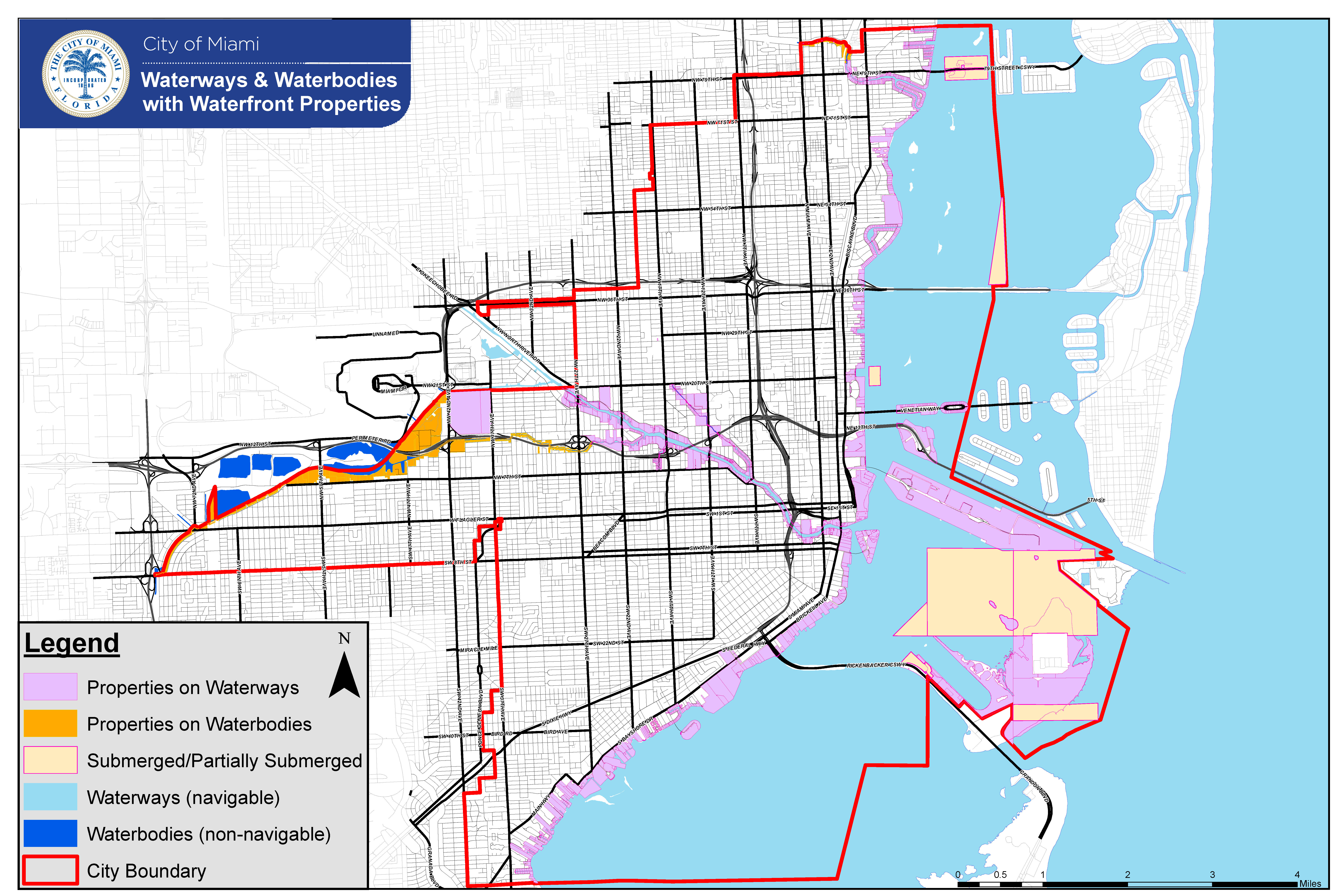
3.11 WATERFRONT STANDARDS
In addition to the Miami City Charter requirements, the following Setback, walkways and Waterfront standards shall apply to all Waterfront properties within the City, except as modifications to these standards for all Waterfront properties may be approved by the City Commission pursuant to the procedures established in the City Charter.
All Miami riverfront properties shall include water-related uses across all Transect Zones except T3.
- Waterfront Setbacks
- For properties fronting a Waterway, the Setback shall be a minimum of fifty (50) feet measured from the mean high water line provided along any Waterfront, except where the depth of the Lot is less than two-hundred (200) feet the Setback shall be a minimum of twenty-five percent (25%) of the Lot depth; and except for T3, T4-R, D1, D2 and D3 Transect Zones where a minimum Setback of twenty (20) feet shall be provided, except where the depth of the Lot is less than eighty (80) feet the Setback shall be a minimum of twenty-five percent (25%) of the Lot depth. These requirements shall not apply to Marine Related Industrial Establishments along the Miami River. Within D1, D2 and D3 Transect Zones facilities may span across man-made slips with a Structure to conduct marine-related commercial and industrial activities.
- For properties fronting a Waterbody, the Setback shall be a minimum of twenty-five (25) feet measured from the mean high water line provided along any Waterfront, except for the following:
- Where the depth of the Lot is less than one-hundred (100) feet, the Setback shall be a minimum of twenty-five percent (25%) of the Lot depth; and
- For T3, T4-R, D1, D2, and D3 Transect Zones, a minimum Setback of twenty (20) feet shall be provided, except where the depth of the Lot is less than eighty (80) feet, the Setback shall be a minimum of twenty-five percent (25%) of the Lot depth.
For other Lot configuration conflicts, the Setback may be reduced a maximum of fifty percent (50%) by process of Waiver.
- Waterfront Side Setbacks consisting of one (1) or more lot lines generally perpendicular to the greatest adjacent body of water shall be equal in aggregate to at least twenty-five percent (25%) of the water frontage of each Lot based on average Lot Width, to allow View Corridors open from ground to sky and to allow public access to the Waterfront; except for T3, T4-R, D1, D2 and D3 Transect Zones.
- Waterfront Walkways Design Standards:
- Waterfront walkways shall be designed and constructed within the Waterfront Setbacks in accordance with these Waterfront Walkway Design Standards and should remain open to public access during all times, but at a minimum, shall remain open to the public between 6am through 10pm. Waterfront walkways are not required within Transect Zones T3, T4-R, D1, D2 and D3 unless the site is a new Commercial retail, Office, Lodging or restaurant Use. Properties along a Waterbody shall only require a Waterfront walkway if it has been identified within the Miami River Greenway Action Plan or other Waterfront Master Plans as a component of a publicly accessible Greenway and Blueway network system within the City and Miami-Dade County.
- Waterfront walkways shall feel public, meet all Americans with Disabilities Act (A.D.A.) requirements throughout the entire length of the Waterfront walkway and provide unobstructed visual access to the water.
- Waterfront walkways shall connect to abutting public walkways, neighboring walkways, and Open Space at a consistent A.D.A. compliant width and grade to allow clear pedestrian circulation along the water’s edge. Properties abutting a Thoroughfare or Public Frontage shall coordinate with the appropriate agency or organization on improvements and connections to Waterfront walkways required on those properties.
- The Waterfront walkway surface shall remain at a constant elevation and be accessible to handicapped persons throughout the entire length of the Waterfront walkway. Walkways should have a slight grade away from the bulkhead edge for stormwater retention within the transition zone.
- All Waterfront walkways shall be built to the standards and guidelines outlined within the Miami River Greenway Regulatory Design Standards, Miami River Greenway Action Plan, and Waterfront Design Guidelines, Appendix B of this Code.
- The total width of a Waterfront walkway shall be a minimum of twenty-five (25) feet per Appendix B, unless the Setback is reduced when the depth of the Lot requires it. Waterfront walkway Design Standards shall apply in the entirety of the Setback when properties are set back less than twenty-five (25) feet. Standards may be adjusted by process of Waiver, but shall not diminish the Circulation Zone identified within Appendix B, with a clear path no less than twelve (12) feet in total width provided.
- Waterfront Properties that do not provide a Waterfront walkway within the Waterfront Setback area shall remain unimproved by any permanent Structure or other Structures permitted under Section 62-528 or Section 62-535 of the City Code.
Diagram 1: Waterways & Waterbodies with Waterfront Properties.
3.12 DESIGN GUIDELINES, NEIGHBORHOOD CONSERVATION DISTRICTS, AND NEIGHBORHOOD REVITALIZATION DISTRICTS AND STREETSCAPE MASTER PLANS
3.14 PUBLIC BENEFITS PROGRAM
The intent of the Public Benefits Program established in this section is to allow bonus Building Height in T5 and T6 Zones, bonus FLR in T6 Zones, and bonus Building Height in D1 Zones, subject to certain conditions, in exchange for the developer’s contribution to specified programs that provide benefits to the public.
3.15 AFFORDABLE AND ATTAINABLE MIXED-INCOME HOUSING SPECIAL BENEFIT PROGRAM SUPPLEMENTAL REGULATIONS
The intent of the Affordable Housing special benefit program established in this section is to facilitate the development of high quality Affordable Housing in the City by providing development incentives, including, but not limited to, modifications of architectural/design standards and parking reductions.
3.16.A. WORKFORCE HOUSING SPECIAL BENEFIT PROGRAM SUPPLEMENTAL REGULATIONS
3.16.B WORKFORCE LIVING DEVELOPMENT HOUSING PROGRAM SPECIAL BENEFIT SUPPLEMENTAL REGULATIONS
3.17 PUBLIC ART REQUIREMENTS
Government Development Projects shall comply with all applicable provisions of the Public Art Program pursuant to Article 11 of this Code and Chapter 62, Article XVI, of the City Code, as applicable.
3.18 ANCILLARY DWELLING UNIT (ADU) STANDARDS
- ADUs shall comply with the Florida Building Code, City of Miami Code, and all other applicable standards of the Miami 21 Code. Additionally, an ADU shall conform to the following standards:
- Allowable Locations
- An ADU, as defined in Article 1, titled ‘Definitions’, may be permitted in those Transect Zones pursuant to Article 4, Table 3, titled ‘Building Function: Uses’, on Lots containing a Single-Family Residence.
- Ownership and Use
- As an ADU is a Residential Use, an ADU must be used as predominately permanent housing.
- The Single-Family Residence and the ADU shall be under the same ownership.
- An ADU may only be rented if the property has current proof of Homestead status.
- ADUs are subject to registration and annual renewal requirements of the City Code.
- When all of the following spaces are provided and are separate from the uses within the Principal Dwelling Unit, it shall be deemed an ADU.
- Sleeping / living area; and
- Shower / bathroom; and
- Kitchen that incorporates a sink, countertop for food preparation, and refrigerator.
- Unit Sizes
- See Article 6, titled ‘Supplemental Regulations’, Table 13; that sets out the minimum and maximum ADU unit sizes.
- Placement
- An ADU shall either be within the Principal Building or an Ancillary Building. See Article 5, titled ‘Specific to Zones’; that provides the specific Principal Building and Ancillary Building design standards and illustrations.
- A one-Story Ancillary Building may be attached or detached from the Principal Building and shall follow the Setbacks for Ancillary Buildings.
- A two-Story Ancillary Building:
- Detached from the Principal Building shall be separated by a minimum of ten (10) feet and shall follow the Setbacks for Ancillary Buildings.
- Attached to the Principal Building shall follow the Setbacks for the Principal Building.
- Height
- Ancillary Buildings shall be limited to two (2) Stories, with the exception of those located in T3-R, which shall be limited to one (1) Story.
- Ancillary Buildings shall be no taller than the Principal Building. See Article 5, Illustrations.
- Entrances and Elevations
- See Article 4, Table 12 for Design Review Criteria.
- The ADU shall have a separate entrance from the Principal Dwelling Unit.
- Principal Buildings containing an ADU shall be designed visually as one single-family residence and the ADU entrance shall not face the street.
- Ancillary Buildings shall be visually harmonious with the architecture of the Principal Building.
- Any Elevation of an Ancillary Building that Abuts another property shall provide only clerestory windows, no more than 24 inches in height, on the corresponding second-Story.
- Ancillary Buildings containing an ADU are encouraged to have Awnings, Canopies and/or an associated outdoor area.
- Parking
- See Article 4, Table 4, titled ‘Density, Intensity and Parking’, that lists the parking requirements.
- Where an existing legal Principal Building prevents the required ADU parking space from being placed within the Second or Third Layer, said parking space:
- May be placed within the First Layer.
- Shall be exempted from the required Driveway separation distance.
- Shall utilize parking strips. Said strips shall not exceed two (2) feet in width.
- Shall be exempted from the First Layer pervious / impervious pavement requirements.
- Allowable Locations
3.19 TRANSIT STATION NEIGHBORHOOD DEVELOPMENT
The intent of the Transit Station Neighborhood District (“TSND”) established in this section is to provide a framework for increased Density and Intensity, consistent with the Future Land Use Map (“FLUM”) of the Miami Comprehensive Neighborhood Plan (“MCNP”), in Transit Oriented Development (“TOD”) areas in order to promote responsible urban development and encourage transit ridership.
3.1.1
The Miami 21 Code Transect Zones are described in Article 4, Table 1 and include the standards summarized in Article 4, Table 2 and further described in Article 5. They range in Function and Density from low-Density, primarily residential areas to high Density Mixed-Use areas, across the Transect, with zones identified as T1, T2, T3, T4, T5, T6, CS, CI, CI-HD, D1, D2 and D3 and all R, L, O and T6 subcategories.
3.3.1
Lots assembled into one (1) ownership within one (1) Transect Zone may be developed as a single Lot. Lots assembled into one (1) ownership that encompass more than one (1) Transect Zone shall be developed according to the corresponding Transect regulation for each Lot, except as described in Section 3.6.1(e). In such cases, there shall be no transfer of Density or Intensity of Development Capacity between Transect Zones, except if the Lots are assigned equal Densities, Density may be transferred across the Transect boundary. Lots under the same or different ownership that are participating in the Historic Preservation Transfer of Development Density program established in Chapter 23 of the City Code may transfer Density from historically designated properties or certain non-contributing resources to TOD areas, subject to compliance with all applicable regulations. Where Lots are assembled into one (1) ownership, the side or rear Setbacks sharing the Property Line may be eliminated. Lot assembly shall require a Unity-of-Title acceptable to the City Attorney. Contiguous Lots in one (1) ownership, as of the effective date of this Code, may be developed as one (1) Lot in excess of the maximum Lot size.
In addition, for development within the Southeast Overtown Park West Community Redevelopment Agency (SEOPW CRA) area, contiguous Lots under common ownership or assembled via a covenant in lieu of Unity of Title for one (1) or more Buildings may exceed maximum Lot Area (Lot Size) for Uses that serve the neighborhood and upon determination of compliance with neighborhood compatibility performance criteria set forth below:
- The development is located within the SEOPW CRA area of a) the Overtown Cultural and Entertainment District or b) the Overtown Culmer Community identified within the SEOPW CRA Redevelopment Plan;
- The development project accomplishes a minimum of one (1) Goal from each of the fourteen (14) Guiding Principles within the SEOPW CRA Redevelopment Plan;
- Building Facades on Primary and Secondary Frontages shall emphasize activated ground floor Habitable Space and incorporate façade treatments that are compatible with the neighborhood character and implement variations in façades through art, glass, or architectural treatments and materials of a design approved by the Planning Director with the recommendation of the UDRB;
- Provides for native species street trees within the verge with a DBH of 25% above the typical standards required by a Street Tree Master Plan and Chapter 17 of the City Code;
- When required, the Cross-Block Pedestrian Passage, shall be at least fifty percent (50%) open to the sky, which connects at least two (2) Thoroughfares, or which is aligned so as to connect with another Cross-Block Pedestrian Passage across a Thoroughfare to the subject property, and is publicly accessible 24-hours a day or reduced hours by process of Waiver; and
- Public benefit contribution provided pursuant to Section 3.14 of this Code within the SEOPW CRA shall be allocated to the Parks and Open Spaces Trust Fund for the I-395 Underdeck Open Space development.”
3.3.2
In Transect Zones T5, T6, CI, CS, D1, D2, and D3, buildable sites shall Enfront a vehicular Thoroughfare or a Pedestrian Passage, with at least one Principal Frontage.
3.3.3
Lots facing Thoroughfares on more than one (1) side shall have designated Principal Frontage(s) and may have Secondary Frontage(s). Unless otherwise designated by a Special Area Plan, a Principal Frontage shall be that facing the Thoroughfare of higher pedestrian importance or intensity (i.e., traffic volume, number of lanes, etc.), as determined by the Planning Director upon request by the Zoning Administrator.
- If two Thoroughfares are of equal importance each Frontage shall be considered a Principal Frontage. Lots with two or more Frontages may consider other non-fronting Property Lines as sides.
- Lots shall have at least one (1) Principal Frontage, except Waterfront Lots shall have at least two (2) Principal Frontages, one of which shall be the Waterfront and shall conform to Waterfront Setback Standards. However, Lots which do not require a Waterfront walkway pursuant to Section 3.11 shall not consider the Waterfront as a Principal Frontage. For Waterfront Setbacks, see Section 3.11 and Appendix B - Waterfront Design Guidelines.
- Where an existing lot of record is located adjacent to a Thoroughfare in a manner that creates an irregular Frontage such that the side or rear yards cannot be determined as with a regular Lot, the Zoning Administrator shall determine, by Waiver, the side and rear yards and Setbacks for the Lot with due regard to the orientation of Structures and buildable areas on the Lot and relationship to adjoining properties. Prior to submitting an application for a Waiver under this Code, the prospective applicant shall meet with the Zoning Administrator in a preapplication meeting to review guidelines for determining existing site conditions and allow the evaluation to adjust minimum dimensions for Setbacks of the Lot due to site constraints or hardships.
3.3.4
For the purposes of this Code, Lots are divided into Layers which control Development on the Lot.
3.3.5
Adjustments to Setbacks to match the dominant Setback of the block and its Context for Structures and Buildings shall be pursuant to Article 5, titled “Specific to Zones".
3.3.6
For new Buildings in Established Setbacks Areas, the Established Setback shall be maintained. (See also Article 4, Diagram 10) Galleries and Arcades may be permitted within the First Layer in Established Setback Areas and shall not encroach the Public Right-of-Way except by Special Area Plan. Where a Gallery or Arcade is permitted, the Established Setback shall only be maintained if a Gallery or Arcade is provided. Where a Gallery or Arcade is not provided, the setback for the underlying Transect Zone shall be maintained.
Established Setback Areas include:
- Brickell Financial
- Boundary: All properties on Brickell Avenue between SE 15th Road and the Miami River.
- Brickell Avenue Setback: Thirty (30’) feet; Side and Rear: Fifteen (15’) feet;
- Brickell Avenue Front Setback Encroachments: For Rights-of-Way with an adjacent Sidewalk ten (10) feet or greater, stairs, ramps, and other elements used for vertical circulation and landscaping may encroach up to twenty-five (25') feet for that portion of the site where the adjacent Sidewalk is ten (10) feet or greater. Encroachments shall incorporate the following design elements:
- provide moderate grading transition when a grade change is required;
- integrate and harmonize with the design of the adjacent Building Façade, Civic Space Type or Landscape Plan;
- provide enhanced streetscape quality, hardscape design, landscape elements, furnishing elements, and lighting; and
- comply with Article 4 Table 12: Design Review Criteria.
- Boundary: All properties bounded by SE 1st Avenue to the west, SE 8th Street to the north, Biscayne Bay to the east and SE 15th Road to the south.
- Interior Side and Rear Setback: fifteen (15’) feet
- Boundary: All properties on Brickell Avenue between SE 15th Road and the Miami River.
- Biscayne Boulevard
- Boundary: All properties along the west side of Biscayne Boulevard from NE 7th Street to NE 12th Street and both sides of Biscayne Boulevard from NE 12th Street to NE 17th Street.
- Setback Adjacent to Biscayne Boulevard: Fifteen (15’) feet
- Boundary: Biscayne Boulevard from NE 17th Street to Interstate 195.
- Setback Adjacent to Biscayne Boulevard: Zero (0’) feet with Gallery
- Boundary: All properties along the west side of Biscayne Boulevard from NE 7th Street to NE 12th Street and both sides of Biscayne Boulevard from NE 12th Street to NE 17th Street.
- Design District
- Boundary: All properties bounded on the east by Biscayne Boulevard; on the south by NE 36th Street; on the west by North Miami Avenue; and on the north by NE 40th Street.
- Frontage Setback: Zero (0’) feet
- Boundary: All properties bounded on the east by Biscayne Boulevard; on the south by NE 36th Street; on the west by North Miami Avenue; and on the north by NE 40th Street.
- 27th Avenue Coconut Grove
- Boundary: The west side of 27th Avenue from SW 28th Terrace to South Dixie Highway.
- 27th Avenue Frontage Setback: Twenty-five (25’) feet
- Boundary: The north side of SW 28th Terrace between South Dixie Highway and SW 27th Avenue.
- SW 28th Terrace Frontage Setback: Fifteen (15’) feet
- Boundary: Bird Avenue between Mary Street and Aviation Avenue; Lincoln Avenue between SW 27th Avenue and Darwin Street; the north Side of Abaco Avenue from SW 27th Avenue to Washington Street; the south Side of Aviation Avenue from SW 27th Avenue to Swanson Avenue.
- Frontage Setback on all streets except SW 27th Avenue: Fifteen (15’) feet
- Boundary: The west side of 27th Avenue from SW 28th Terrace to South Dixie Highway.
- 9th Street Promenade
- Boundary: All properties Adjacent to NW 9th Street between NW 2nd Avenue and North Miami Avenue.
- NW 9th Street Frontage Setback: Twenty-five (25’) feet
- Boundary: All properties Adjacent to NW 9th Street between NW 2nd Avenue and North Miami Avenue.
- Tigertail Avenue
- Boundary: All properties along the southeast side of Tigertail Avenue between Darwin Street and Aviation Avenue.
- Tigertail Avenue Setback: One hundred feet (100’) except, Residential Uses (as ancillary Use), may be developed in accordance with Setback provisions of the underlying Transect Zone. Parking structures lined by Residential Uses must be setback a minimum of fifty (50’) feet from Tigertail Avenue.
- Boundary: All properties along the southeast side of Tigertail Avenue between Darwin Street and Aviation Avenue.
- South Bayshore Drive
- Boundary: All properties on the northern side of South Bayshore Drive from McFarlane Road to Aviation Avenue.
- South Bayshore Drive Setback: Thirty (30’) feet; Side Setback: fifteen (15’) feet minimum for the entire height of the building.
- Boundary: All properties on the northern side of South Bayshore Drive from Aviation Avenue to SW 17th Avenue.
- South Bayshore Drive Setback: Eighty (80’) feet
- Boundary: All properties on the northern side of South Bayshore Drive from McFarlane Road to Aviation Avenue.
- Coral Way
- Boundary: Coral Way from the western City limits (SW 37th Avenue) to SW 1st Court.
- Coral Way Setback: Zero (0’) feet with Gallery
- Boundary: Coral Way from the western City limits (SW 37th Avenue) to SW 1st Court.
- 8th Street
- Boundary: All properties Adjacent to SW 8th Street between SW 27th Avenue and SW 1st Court.
- SW 8th Street Setback: Zero (0’) feet with Gallery
- Boundary: All properties Adjacent to SW 8th Street between SW 27th Avenue and SW 1st Court.
- 22nd Avenue
- Boundary: 22nd Avenue from NW 1st Street to SW 8th Street.
- 22nd Ave Setback: Zero (0’) feet with Arcade
- Boundary: 22nd Avenue from NW 1st Street to SW 8th Street.
- Central Coconut Grove
- Boundary:
- All properties Adjacent to Grand Avenue between Margaret Street and Mary Street.
- All properties Adjacent to Commodore Plaza between Grand Avenue and Main Highway
- All properties Adjacent to Fuller Street between Grand Avenue and Main Highway.
- All properties Adjacent to Main Highway between Charles Avenue to Grand Avenue.
- All properties Adjacent to McFarlane Road between Grand Avenue and South Bayshore Drive.
- All properties Adjacent to Virginia Street between Oak Avenue and Grand Avenue.
- All properties Adjacent to Florida Avenue between Virginia Street and Mary Street.
- All properties Adjacent to Rice Street between Oak Avenue and Florida Avenue.
- All properties on the west side of Mary Street between Oak Avenue and Grand Avenue.
- All properties on the south side of Oak Avenue between Matilda Street and Tigertail Avenue.
- Central Coconut Grove Setback (on the streets listed above): Five (5) feet.
- Wynwood
- Boundary: Established Setback Areas have been identified within Wynwood NRD-1 Street Master Plan located within Appendix J of this Code.
- Wynwood Norte
- Boundary: Established Setback Areas have been identified within Wynwood NRD-2 Street Master Plan located within Appendix P of this Code.
- Downtown East Flagler Street
- Boundary: All properties Adjacent to East Flagler Street between West 1 Avenue and Biscayne Boulevard
- Frontage Setback: Zero (0’) feet
- Setback above the 8th Story: ten (10’) feet
- Boundary: All properties Adjacent to East Flagler Street between West 1 Avenue and Biscayne Boulevard
3.4.1
Lot Area, inclusive of any dedications for Right-of-Way purposes since the last recorded plat, but no earlier than August 8, 1934, shall be used for purposes of Density and Intensity calculation. Evidence in the form of a deed (i.e. Right-of-Way, warranty or other deed) and a survey showing that said dedication for Right-of-Way purposes was granted after August 8, 1934 shall be provided to the Office of Zoning.
3.4.2
Density shall be calculated in terms of units as specified by Article 4, Tables 3 and 4. The referenced tables provide the maximum allowable Densities. Intensity shall be calculated in terms of Floor Lot Ratio. The buildable Density or Intensity on any particular site will be affected by other regulations in this Code and thus the stated maximums of this Miami 21 Code may exceed the actual Capacity that a site can sustain when other regulations of this Code are applied to the site. The inability to reach the maximum Density or Intensity because of the necessity to conform to the other regulations of this Code shall not constitute hardship for purposes of a Variance.
3.4.3
Lodging Units shall be considered as equivalent to one-half (0.50) of a Dwelling Unit.
3.4.4
Co-Living Rooms shall be considered as equivalent to one-quarter (0.25) of a Dwelling Unit. Co-Living Units with less than four (4) Co-Living Rooms shall be considered minimum one (1) Dwelling Unit.
3.4.5
- The allowable Transect Zone Density may be increased as provided by the Future Land Use Element of the Miami Comprehensive Plan (Residential Density Increase Areas), as illustrated in Article 4, Diagram 9.
Properties with an underlying Comprehensive Plan designation that provides for a greater Density than the zoning and meets subsection 3.4.5.2 (a) or (b) below, the applicable Density shall be as permitted by the underlying Comprehensive Plan designation.
Properties within one-half (1/2) mile of a Metrorail, Brightline, or Tri-Rail station; or
T5-O sites located within one of the following Transit Corridors:
NW 7th Avenue
ii. Biscayne Boulevard
3.5.1
Unless otherwise specified herein, the Height of Buildings shall be measured in Stories. The height of Fences, walls and Structures shall be measured in feet. The Height of Buildings, Structures, Fences and walls shall be measured from the Average Sidewalk Elevation or, where no sidewalk exists, the average of the record profile grade elevation of the street Abutting the Principal Frontage of the Building, as determined by the Public Works Department, provided however where Section 20-3 (11) of the City Code defines a higher elevation of the adjacent street, that higher future elevation shall control. In the event that the Base Flood Elevation, as established by FEMA, plus Freeboard, is higher than the sidewalk or grade elevations, the total Height of the Building but not the height of Fences and walls shall be measured from the Base Flood Elevation plus Freeboard.
3.5.2
- For all Transect Zones:
- A Story is a Habitable level within a Building with a maximum Height of fourteen (14) feet from finished floor to finished floor.
- Basements are not considered Stories for the purposes of determining Building Height.
- For specific Transect Zones, except the T3 Transect Zone:
- A ground-level Story may exceed this limit up to a total height of twenty-five (25) feet, and
- A a top-level Story in the T5, T6 Transect Zone may exceed this limit up to a total height of twenty-eight (28) feet and count as one (1) Story, if the Building Height does not exceed the maximum Building Height including all applicable bonuses allowed by the transect at fourteen (14) feet per floor and twenty-five (25) feet at the ground level.
- A ground-level Story may exceed fourteen (14) feet up to a total height of thirty (30) feet when located in the Special Flood Hazard Area, given that the finished floor of the ground level meets the Average Sidewalk Elevation.
- A single floor level exceeding fourteen (14) feet or twenty-five (25) feet at ground level (or thirty (30) feet at ground level within the Special Flood Hazard Area), shall be counted as two (2) Stories; except for T6-36, T6-48, T6-60, T6-80, and D1, where a single floor level exceeding fourteen (14) feet may count as one (1) story if the Building Height does not exceed the maximum height, including all applicable bonuses, allowed by the transect at fourteen (14) feet per floor.
- The first two Stories’ total combined Height shall not exceed thirty-nine (39) feet, or forty-four (44) feet in the Special Flood Hazard Area.
- The first floor shall be a minimum of fourteen (14) feet in Height, or nineteen (19) feet in the Special Flood Hazard Area.
- Intermediate Levels may not exceed thirty-three percent (33%) of the Floor Area, except in the D1, where Intermediate Levels may not exceed fifty percent (50%) of the Floor Area. Intermediate Levels extending beyond thirty-three percent (33%) of the Floor Area, or fifty percent (50%) of the Floor Area in D1, shall be counted as an additional floor.
- The Height of a Parking Structure concealed by a Liner may be equal to the Height of the Liner; this may result in a Liner Story concealing more than one level of Parking.
3.5.3
Except as specifically provided herein, the Height limitations of this Code shall not apply to any Solar Equipment or roof Structures for housing elevators, stairways, tanks, ventilating fans, or similar equipment required to operate and maintain the Building. Roof Structures shall not cover more than twenty percent (20%) of roof area for T4 and T5. Solar Equipment may cover an entire roof area. Church spires, steeples, belfries, monuments, water towers, flagpoles, vents, or similar Structures, may be allowed to exceed the maximum Height by Waiver. Fire or parapet walls, which shall not extend more than five (5) feet above the maximum Height in T4 and T5 and ten (10) feet in T6 and Districts are allowed.
3.5.4
No Building or other Structure shall be located in a manner or built to a Height which constitutes a hazard to aviation or creates hazards to persons or property by reason of unusual exposure to aviation hazards. In addition to Height limitations established by this Code, limitations established by the Miami-Dade County Height Zoning Ordinance as stated in Article 37 of the Code of Miami-Dade County (Miami International Airport) shall apply to Heights of Buildings and Structures.
3.5.5
Height limitations for Properties Abutting and in Proximity to National Historic Landmarks
- All properties designated a National Historic Landmark (NHL) which include a Designed Landscape that is an integral part of the documented significance supporting the NHL designation shall be protected by height limitations throughout the entire Civic Institution zoned property of which the NHL is a part, so as to protect the Designed Landscape from the potentially adverse effects of an undertaking that may diminish the integrity of the NHL property’s location, design, setting, materials, workmanship, association or qualities that qualified it for NHL designation. Examples of adverse effects which diminish the integrity of the NHL property include those which: cause physical destruction of or damage to all or part of the NHL property; or change the character of the NHL property’s use or physical features within the NHL property’s setting that contribute to its historic significance; or introduce visual, atmospheric or audible elements that diminish the integrity of the NHL property’s significant historic features; or alter the NHL property in a way that is not consistent with the federal standards for the treatment of historic properties and applicable guidelines, as published by the United States Department of the Interior.
- The height of structures throughout the entire Civic Institution zoned property of which the NHL is a part shall not exceed that established by a six (6) degree vertical plane which is measured beginning from the ground floor elevation of the principal historic building at the façade that overlooks the Designed Landscape, which plane shall extend in a one hundred eighty (180) degree arc facing the Designed Landscape and measured at grade from the midpoint of the building façade. The ground floor elevation shall be measured according to the 1929 N.G.V.D. of Mean Sea Level supplied by the City of Miami. Structures existing on affected properties at the time of the effective date of this Miami 21 Code shall not be considered nonconforming structures.
- Should the height limitations for structures located in such Civic Institution zoned property as of the effective date of this Miami 21 Code be more restrictive than that created by this section, the most restrictive height shall apply. In the event of a rezoning of all or part of the Civic Institution property, either by successional zoning or by Special Area Plan, the height limitations specified in this Section 3.5.5 shall be incorporated in all subsequent rezonings.
- For purposes of this Section 3.5.5, the following definitions shall apply:
- Designed Landscape is one or more of the following:
- a landscape that has significance as a design or work of art;
- a landscape consciously designed and laid out by a master gardener, landscape architect, architect, or horticulturalist to a design principle, or an owner or other amateur using a recognized style or tradition in response or reaction to a recognized style or tradition;
- a landscape having a historical association with a significant person, trend, event, etc. in landscape gardening or landscape architecture; or
- a landscape having a significant relationship to the theory or practice of landscape architecture.
- National Historic Landmark is a nationally significant historic place designated by the Secretary of the Interior because it possesses exceptional value or quality in illustrating or interpreting the heritage of the United States, and defined in Title 36, Section 65.3 of the Code of Federal Regulations.
- Designed Landscape is one or more of the following:
3.5.6
See Chapter 23 of the City Code, titled Historic Preservation, for regulations and additional height requirements.
3.6.1 Off-street Parking Standards
- Off-street Parking requirements for the individual Transect Zones shall be as set forth in Article 4, Table 4. Where required off-street parking is based on square footage of Use, the calculation shall only include Habitable Rooms and Habitable Space occupied by such Use.
- Off-street Parking dimensions and Shared Parking (mixed-use) reduction table shall be as set forth in Article 4, Table 5.
- Required Parking for Adaptive Uses shall be as set forth in Article 7, Section 7.2.8. Nonconforming Site Improvements may be reduced or exempted by Waiver for properties located in a Community Redevelopment Area.
- Parking reductions shall not be cumulative except in T6-36, T6-48, T6-60 and T6-80. Parking reductions shall not exceed fifty percent (50%) of the total Off-street Parking required, except for Residential components of projects within one thousand (1,000) feet of Metrorail or Metromover stations.
- Parking that is otherwise not allowed but that is customarily incidental and subordinate to a principal Use may be provided in any T3 or T4-R Transect Zone by process of Exception and only if there is an existing legally built parking lot. Access for such Lots shall be subject to all other requirements of the Transect Zone including Liner, landscaping, or Streetscreen requirements. Such parking shall not expand or increase the degree of nonconformity. Parking in other Transect Zones shall be approved pursuant to Article 4, Table 3.
- 20% of all newly constructed parking spaces must be EV Capable. In no case will this be less than one (1) required space and the calculated number shall always be rounded up for any fraction of a space. This requirement does not apply to dwellings without a designated parking space located on the premises nor does this requirement apply to parking spaces located in the public right-of-way.
3.6.2 Off-street Parking Driveway Standards [RESERVED]
3.6.3 Additional Off-street Parking Regulations
General performance standards for Off-street Parking facilities:
- Parking shall be implemented so as to provide safe and convenient access to and from public Thoroughfares which include movement lanes and Public Frontages.
- Vehicular access through Residential properties for nonresidential Uses shall be prohibited.
- Off-street Parking spaces shall be located with sufficient room for safe and convenient parking without infringing on any public Thoroughfare or sidewalk.
- Off-street Parking spaces whose locations require that cars back into movement lanes shall only be permissible in T3 and T4 zones. Backing into Alleys shall be permissible in all Transect Zones.
- Off-street Parking or loading area shall not be used for the sale, repair, or dismantling of any vehicle or equipment, or for storage of materials or supplies.
- Parking or storage of commercial trucks, buses, vans, sign trailers; trailers or semi-trailers for freight, cargo; non-recreational watercraft; or the like shall not be permitted in any T3, T4, T5-R or T6-R Zone.
- Inoperable vehicles and other inoperable Recreational Watercraft or equipment shall be stored only in storage facilities or other approved places where they are completely concealed from public view.
- Except in connection with permitted active continuing construction on the premises, construction equipment such as earth moving machines, excavators, cranes, and the like shall only be allowed in D1, D2 and D3, as allowed by this Code.
- All Off-street Parking shall comply with applicable regulations related to lighting, paving, and drainage including the Miami-Dade County Code and the Florida Building Code.
- Specific areas may be set aside for Tandem Parking. Tandem Parking in all Transect Zones, except T3 and T4, shall be used only by a valet parking operator.
- Parking facilities on adjoining Lots may share access points, driveways and parking subject to a recorded covenant running with the property on which the facilities are located, by process of Waiver.
- Stationing of Recreation Watercraft:
- Transect Zones Stationing of Recreational Watercraft may only be permitted in T3, T4-R and T4-L Zones and only where incidental to a Single-Family Residence. This section shall not be construed as preventing the docking of boats along the waterfront.
- Screening Screening arrangements shall be made to buffer view of the Recreational Watercraft from Abutting parcels by means of walls, fences or landscaping of sufficient opaqueness to visually conceal its bulk while in keeping with applicable provisions in Article 3 and 5.
- Occupancy Recreational Watercraft stationed in T3, T4-R and T4-L Zones shall not be used as Residential or other Occupancies.
- Location Stationing of Recreational Watercraft may only be permitted when placed within the Second or Third Layer of the property.
- Height The maximum height of the Recreational Watercraft shall not exceed eight (8) feet, inclusive of trailer and excluding Minor Accessories.
- State or condition Stationing of Recreational Watercraft in T3, T4-R and T4-L Zones may only be permitted as long as the Recreational Watercraft is maintained in an orderly and seemly condition.
3.6.4 Calculation of Off-street Parking requirements related to number of seats.
Where parking requirements relate to number of seats and seating is in the form of undivided pews, benches, or the like, twenty (20) lineal inches shall be construed to be equal to one (1) seat. Where Parking requirements relate to movable seating in auditoriums and other assembly rooms, ten (10) square feet of Floor Area shall be construed to be equal to one (1) seat except where otherwise specified. Net floor area shall be the actual area occupied by seating and related aisles, and shall not include accessory unoccupied areas or the thickness of walls.
3.6.5 Valet Parking
Off-street Parking facilities maintained with valet parking shall be allowed generally, provided that the minimum Off-street Parking requirements of this Code are satisfied and that an attendant shall remain on duty during business hours or as long as the Principal Building is occupied.
3.6.6 Parking Management Plan
Parking allowed off-site through a parking management plan agreement with the City of Miami Parking Authority shall be as set forth in Chapter 35 of the City Code.
Within areas under a parking management plan, outdoor areas, including the public right-of-way, which are regularly used for display and sales, or as dining areas, shall be calculated as part of the establishment’s total floor area and shall comply with Off-Street parking requirements.
3.6.7 Off-street Parking Reductions by Use
- Parking reductions for Elderly Housing.
- Housing for the Elderly, in relation to this regulation, is not to be construed as homes or institutions for the aged which are primarily convalescent or Nursing Homes.
- Off-street Parking space requirements in connection with Housing for the Elderly conforming to the requirements of state or federal programs may be reduced by process of Warrant to a minimum of one (1) parking space per every two (2) Dwelling Units.
- The applicant shall submit a parking management plans which demonstrates how the parking deficiency will be mitigated in the event that the housing becomes market rate housing at some time in the future.
The following criteria shall apply:- The premises shall be used as Housing for the Elderly, subject to the exceptions and limitations set forth in (a) above, until the parking requirements for a different Use have been met; and
- The applicant shall demonstrate that the reduction in Off-street Parking is justified in view of the nature and type of prospective occupancy and the economic circumstances involved, that the impacts from such reduction are not likely to unduly burden traffic and parking facilities in the neighborhood, and there will be adequate Off-street Parking for occupants, visitors, and staff; and
- Applicant shall submit written certification from the applicable City, State or Federal agency in charge of the program.
- Parking Reduction for Low-Income Housing
- Off-street Parking requirements in connection with housing for low income families and individuals may be reduced by process of Exception only up to fifty percent (50%) of the spaces generally required. Housing for low-income families and individuals shall be qualified by the City of Miami Department of Community Development.
- The applicant shall submit plans which demonstrate how the remaining parking may be accommodated in the event that the housing becomes market rate housing at some time in the future.
The following criteria shall apply:- The project shall otherwise conform to the requirements of state or federal programs for this purpose.
- The Board, in its consideration of the application for Exception, shall determine and make a finding that the reduction in Off-street Parking requirements is justified in view of the nature and type of prospective occupancy and the economic circumstances involved, and that traffic and parking problems resulting from such reduction will not unduly burden traffic facilities in the Neighborhood.
- The Board shall, as part of its grant of Exception, specify that the City, upon notice and review for Waiver, may later require that the applicant implement its plan to provide the full amount of required parking if it is demonstrated that traffic and parking conditions together with impact on the Neighborhood require such provision.
- After such permit has been issued, the premises shall not be used other than as Low Income Housing, subject to the Exception and limitations set forth in (a) above, unless and until any parking requirements and all other requirements or limitations of this Code have been met.
3.6.8 Deferral of Off-street Parking Standards
- Deferral of portions of total required parking improvements in phased projects
Parking requirements shall be met as set forth by this Code and built concurrently with approved improvements generating said requirement. Provision of parking should not in part or in whole be deferred for future implementation. Further, phased projects shall be approved subject to provision of required parking for each component phase to be provided concurrently with the phase generating said requirement; however deferrals may be granted by Exception as specified below. - Deferral period, revocation of permit; notice of revocation.
A deferral may be allowed for up to five (5) years without provision for renewal except upon application for a new Exception.
3.6.9 Off-street Loading Requirements
- Off-street vehicular loading shall be required for all T5, T6, CS, CI, CI-HD and D zones, as shown in Article 4, Table 5 and shall require no more than three (3) turning movements.
- Within the Downtown Flagler Parking and Loading Improvement District as described in Exhibit “A”, attached and incorporated, Loading for non-residential uses may be provided on-site or off-site as established in Chapter 35 of the City Code and further described in Article 4, Table 4 by process of Waiver and after a Covenant, in a form acceptable to the City Attorney, running with the land is recorded upon both the property on which the Loading will occur and the property which requires the Loading.
3.6.10 Off-street Bicycle Parking Requirements
- Off-street bicycle parking shall be provided for all T4, T5, T6, CS, CI, CI-HD, and D zones, as shown in Article 4, Table 4 and shall be calculated prior to any vehicular parking reductions.
- Within TOD areas, required bicycle parking shall be provided as both Short-Term Bicycle Parking and Long-Term Bicycle Parking as described within the Miami Bicycle Master Plan.
- Short-Term Bicycle Parking may be located within the public ROW or a required Setback, within 200 feet of the building’s entrance.
- Long-Term Bicycle Parking shall be located within a built structure subject to the standards outlined below.
- Required bicycle parking shall meet the following standards:
- Required bicycle parking shall be provided in a safe, accessible and convenient location.
- Bicycle parking facilities shared by more than one use are encouraged.
- Required bicycle parking facilities may be located within the project site or in a shared bicycle parking facility subject to all the conditions for shared bicycle parking facilities below:
- Required bicycle parking spaces for two (2) or more adjacent sites may be satisfied by the same bicycle parking facility used jointly provided that such right of joint use and maintenance is evidenced by covenant running with the land or equivalent legal document establishing the joint use.
- Required shared bicycle parking facilities are to be located within 300 feet of any building’s main entrance.
- The minimum number of required bicycle parking is satisfied by all sites using the shared facility.
- For the purposes of this section, shared bicycle parking facilities are areas, locations, or structures designed to accommodate, house, store, maintain or hold several bicycle parking spaces.
- When required off-street vehicular parking is covered, the required bicycle parking shall also be covered.
- When required bicycle parking is provided in racks, one (1) standard U-rack will accommodate two (2) bikes and each rack must meet the following standards:
- The bicycle frame and one (1) wheel can be locked to the rack with a high security, U-shaped shackle lock if both wheels are left on the bicycle;
- A bicycle six feet long can be securely held with its frame supported so that the bicycle cannot be pushed or fall in a manner that will damage the wheels or components; and
- The rack must be securely anchored.
- When required bicycle parking is provided in lockers, the lockers must be securely anchored.
- Parking and maneuvering areas.
- Each required bicycle parking space must be accessible without moving another bicycle;
- There must be an aisle of at least five (5) feet wide behind all required bicycle parking to allow room for bicycle maneuvering;
- The area devoted to bicycle parking must be hard surfaced.
- A one (1) square foot directional sign shall be required if the bicycle parking area is not visible from the street or main building entrance. Said sign must be posted at the main building entrance indicating the location of the bicycle parking.
3.7.1 General
For all Commercial and Industrial Uses, a six-foot (6) solid masonry wall shall be provided along all property lines which adjoin T3, T4-R, T5-R and T6-R.
3.7.2 Prohibited on Fences and walls
- The use of broken glass, projecting nails, coiled razor wire, spikes or similar materials on walls and Fences is prohibited in all Transect Zones.
- Barbed wire Fences, or use of barbed wire along the top of a fence or wall, shall be permissible only in D1, D2 and D3, subject to approval by Waiver upon making a written finding that its use and placement are reasonably necessary to the safety, welfare and security of the property.
3.8.1 General Principles
- Thoroughfares are intended for use by vehicular, transit, bicycle, and pedestrian traffic and to provide access to Lots and Open Spaces.
- Thoroughfares consist of lanes for vehicles, transit, bicycles and Public Frontages. The lanes may have a variety of widths for movement and parking. The Public Frontages contribute to the character of Transect Zones. They may include swales, Sidewalks, curbing, Planters, bicycle paths and street trees. See Article 4, Tables 6 and 8.
- Thoroughfares should be designed in context with the urban form and desired design speed of the Transect Zones through which they pass. The Public Frontages that pass from one Transect Zone to another should be adjusted accordingly.
- Bicycles are a sustainable and viable mode of transportation and recreation in the City of Miami. Bicycle use of Thoroughfares should be as follows: Bicycles and vehicles may share use of lanes on all Thoroughfares. Thoroughfares that have sufficient paving width to accommodate bicyclists’ safety should include dedicated Bicycle Lanes. Greenways, waterfront walks and other Civic Spaces should include Bicycle usage .
- A City-wide bicycle plan may designate an interconnected network serving bicyclists with a series of marked routes that include Bicycle Lanes as well as Bicycle Routes that give bicycles priority, such as those Thoroughfares which parallel major corridors or include major corridors which can be reconfigured to limit conflicts between vehicles and bicycles.
- Pedestrian comfort should be a primary consideration of Thoroughfare design and dimensions. Design conflict between vehicular, bicycle and pedestrian movement should be decided in favor of the pedestrian.
3.8.2 Thoroughfares
- The guidelines for Thoroughfares are as described in Article 8.
- The Thoroughfare network should be designed to prioritize connectivity, defining Blocks not exceeding an average perimeter length of 1,320 feet. The length shall be measured as the sum of Lot Frontage Lines. Thoroughfare closings should not be allowed; instead, traffic calming designs should be deployed to control traffic volume and speed.
- All Thoroughfares should terminate at other Thoroughfares, to form a network. Cul-de-sacs should be permitted only when supported by natural site conditions. Thoroughfares that provide View Corridors shall not be vacated.
- In T5 and T6 Zones, Public and Private Frontages should be coordinated with a single paving and landscape design as provided in Article 4, Table 6 and Article 8.
3.8.3 Public Frontages
- Public Frontages should be designed as shown in Article 4, Table 6 and allocated within Transect Zones as specified in Article 4, Table 2.
- Within the Public Frontages, the arrangement of street trees and street lights should be as provided in Article 8.
- The Public Frontage in Transect Zones T1, T2 and T3 should include trees of various species, and may include low maintenance understory landscape. The introduced landscape should consist primarily of native species requiring minimal irrigation, fertilization and maintenance.
- The Public Frontage in Transect Zones T4, T5, T6 and D1 should include trees planted in a regularly-spaced Allée of single or alternated species with shade canopies of a height that, at maturity, clears the first Story. The introduced landscape should consist primarily of durable species tolerant of soil compaction.
3.9.1 General
- The single or multiple owner(s) of Abutting properties in excess of nine (9) acres may apply for a rezoning to a Special Area Plan. For the purposes of applying for a rezoning to a Special Area Plan, the term Abutting shall not include properties separated by the Florida East Coast Railway Corridor or separated across a street or alley with an actual or zoned width of seventy (70) feet or greater as set by Chapter 54, Article V of the City Code.
- A Special Area Plan shall be approved by the process of rezoning with or without Transect changes. Properties designated as “T3” – Sub-Urban Transect Zone shall not be considered for a Special Area Plan.
- A Special Area Plan shall assign Thoroughfares, Transect Zones and Civic Space Types, with appropriate transitions to Abutting areas. Guidelines for Thoroughfares and Public Frontages may be adjusted to the particular circumstances of the Special Area Plan.
- A Special Area Plan shall include a map of the Thoroughfares and Transect Zones, and the standards that deviate from the requirements of Article 5.
- A Special Area Plan shall assign at least five percent (5%) of its aggregated Lot Area to a new Civic Space Type. Civic Building sites are to be located within or adjacent to Civic Space Types or at the axial termination of significant Thoroughfares. The developer shall be responsible for constructing the public improvements within the Special Area Plan, including but not limited to the Civic Space Types and Thoroughfares.
- A Special Area Plan shall provide for additional public benefits above the minimum baseline as outlined in Section 3.14 to reduce any adverse impacts due to an increase in density, intensity and/or height resulting from a rezoning and/or any deviations from the development standards outlined in this Miami 21 Code.
- Development within the Special Area Plan shall be pursuant to a recorded development agreement that will establish the allocation of Thoroughfares and Civic Space Types and Building Area among the Building sites, and the creation and retention of the public benefits.
- Unless a Building is specifically approved as part of the Special Area Plan, any Building shall be reviewed by the Planning Director, after referral to and recommendation from the CRC for conformance to the Plan, prior to issuance of the Building Permit.
- A Special Area Plan may include:
- A differentiation of the Thoroughfares as a Primary-Grid (A-Grid) and a Secondary-Grid (B-Grid). Buildings along the A-Grid shall be held to the highest standard of this Code in support of pedestrian activity. Buildings along the B-Grid may be more readily considered for automobile-oriented standards allowing surface parking lots, unlined parking decks, and drive-throughs. The Frontages assigned to the B-Grid shall not exceed thirty percent (30%) of the total length within a Special Area Plan. For Frontages on the B-Grid, parking areas may be allowed in the Second Layer.
- Retail Frontage requiring that a Building provide a Commercial Use at sidewalk level along the entire length of the Frontage. The Commercial Use Building shall be no less than seventy percent (70%) glazed in clear glass and provided with an Awning overlapping the sidewalk as generally illustrated in Article 4, Table 6. The first floor should be confined to Retail Use through the depth of the Second Layer.
- Gallery or Arcade Frontage, requiring that a Building provide a permanent cover over the sidewalk, either cantilevered or supported by columns. The Gallery or Arcade Frontage may be combined with a Retail Frontage as shown in Article 4, Table 6. Gallery or Arcade Frontage within the First Layer may apply towards Open Space requirements.
- Build-to-lines that differ from Transect Zone Setback requirement.
- A Terminated Vista location, requiring that the Building be provided with architectural articulation of a Type and character that responds to the location.
- A Pedestrian Passage, requiring a minimum ten (10) foot wide pedestrian access be reserved between Buildings.
- A preservation plan acceptable to the Historic and Environmental Preservation Board for any historic resources in the area of the Special Area Plan.
- Area Design Guidelines.
- A parking management program that enables shared parking among public and private Uses.
- Flexible allocation of development capacity and Height, excluding Density on individual sites within the Special Area Plan shall be allowed so long as the capacity or Height distribution does not result in development that is out of Scale or character with the surrounding area, and provides for appropriate transitions.
3.12.1 Design Guidelines
This section lists additional guidelines defining elements to protect and promote Neighborhood or area character, which may be obtained through the Planning Department. In the areas for which guidelines have been adopted, any proposed building shall be reviewed by the Planning Director prior to the issuance of a building permit.
- MLK Boulevard Streetscape Beautification Master Plan and Façade Standards
- Southeast/Overtown Park West Community Redevelopment Plan
- Miami River Greenway Regulatory Design Standards
- Grand Avenue Vision Plan
- Coral Way Beautification Master Plan
- Little Haiti - French Creole Design Standards
- Offstreet Parking Design Standards and Guidelines
- Overtown Folklife Village
- OMNI CRA Streetscapes: Performing Arts & Media Entertainment District
3.12.2 Neighborhood Conservation Districts (NCD)
- Intent
A Neighborhood Conservation District (NCD) is an overlay zoning district that is intended to preserve unique and distinctive neighborhoods that exhibit a certain defined character worthy of protection, such as physical features, design characteristics, and recognized cultural or historical identity. The Neighborhood Conservation District provides additional regulations or design guidelines for new construction, major alterations and additions to existing Buildings, in order to protect, enhance and perpetuate the value of the neighborhood conservation area. It is further intended that such districts and the regulations adopted for them shall be in accord with, and promote the Miami Comprehensive Neighborhood Plan. - Purposes
The purposes of creating a Neighborhood Conservation District, singularly or in combination, are to:- Protect neighborhoods that have distinguishable architectural character but that do not qualify for historic district status because of the loss of the original fabric through attrition and new development, although the neighborhood still maintains a considerable number of non-contiguous traditional structures that retain some characteristics that reflect their historical origins.
- Identify structures within the district that, while not historically designated, possess significant character reflecting a Type, period or method of construction important to Miami’s past. Demolition of such structures will be subject to review prior to receiving a demolition permit.
- Protect areas that have a distinctive landscape, geologic, or environmental character. Protect and promote the lush sub-tropical vegetation and tree canopy that defines the South Florida landscape and gives particular identity to the neighborhood. Protect remaining unique environmental features such as exposed bluffs, natural rock outcroppings, caves, natural sinkholes, and springs.
- Identify and celebrate those neighborhoods whose immigrant or émigré citizens have brought a unique cultural perspective to a neighborhood and which deserve recognition and protection.
- Protect and promote specialized commercial areas with distinct character, such as antique, arts, outdoor markets, or design districts, and assist in their economic revitalization and enhancement.
- Designation Process
The NCD shall be designated by process of rezoning, and shall be initiated by an applicant who submits the following to the Planning Department:- A description of the proposed boundaries of the NCD;
- A description of the distinctive features of the district which are sought to be protected and preserved;
- A list of all property owners within the boundaries of the proposed district;
- Evidence that demonstrates that at least fifty-one (51) percent of the owners within the proposed boundary support the initiation of the NCD rezoning.
The Planning Director shall prepare a recommended conservation plan and any proposed regulations and/or design guidelines as provided in paragraph d. below. The PZAB shall consider the recommendations and provide its recommendations to the City Commission. In addition, the City shall conduct at least one workshop regarding the proposed NCD during the consideration of the rezoning, and notification of the workshop shall be sent by first class mail to all property owners located within the proposed boundaries of the district, as shown on the tax roll, at least thirty days prior to the workshop. The City Commission upon designation of the NCD shall adopt the conservation plan and any requisite regulations for the NCD, and the Zoning Atlas shall be amended to show the district boundaries of the NCD. Amendments to any NCD adopted under this Code shall be adopted pursuant to this Code.
- Recommendation for Neighborhood Conservation District designation
The Planning Department shall prepare a recommendation for the designation of each NCD. Each recommendation shall identify the proposed rezoning by the specific name created for the NCD and shall contain the following information:- A statement of the purposes of the NCD, specifying the substantial public interest involved and the objectives to be promoted by the conservation plan and any special regulations for the district as a whole, or within any subareas of the district which may be recommended.
- The boundaries of the NCD district and any sub-areas, if any, including a map and a general land description of the boundaries.
- An explanation of the boundaries selected that meet the intent and requirements for the NCD.
- A conservation plan identifying and describing the distinctive neighborhood characteristics of the proposed district, with appropriate maps and graphics, and any design guidelines or regulations recommended to promote the purposes of the district. Regulations may require rezoning to different Transect zones than those existing at the time of designation, additional overlay zoning standards, additional overlay zoning processes, or the like, as tailored to the purposes of the specific NCD.
- NCD Land Development Regulations
The requirements of this Code shall be effective in the NCD except as modified by the regulations of the conservation plan adopted by the City Commission upon designation of the NCD.. The ordinance designating the NCD shall be referenced in this Code, with any specific regulations and design guidelines of the NCD adopted by reference to this Code and maintained in the Planning Department.
The Planning, Zoning and Appeals Board and procedures related to appeals thereto set out by this Miami 21 Code shall replace the Zoning Board and procedures related to appeals thereto in Ordinance 11000. - NCD-1 Coral Gate Neighborhood Conservation District
The Coral Gate NCD-1, originally adopted by Ord. No. 12413, on September 25, 2003, is hereby amended and codified in Appendix A.1 to this Code. - NCD-2 Village West Island and Charles Avenue Neighborhood Conservation District
The Village West Island and Charles Avenue NCD-2 incorporates and amends:- The Charles Avenue NCD-2, originally adopted by Ord. No. 12417, September 25, 2003, and repealed and reenacted by Ord. No. 12651, adopted January 27, 2005;
- SD-28, the Village West Ordinance, adopted by Ord. No. 12651, January 27, 2005;
- Portions of SD-2 adopted by Ord. No. 12651, adopted January 27, 2005;
- Portions of the Coconut Grove NCD-3, originally adopted by Ord. No. 12672, September 24, 2005.
The Village West Island and Charles Avenue NCD is hereby adopted and codified in Appendix A.2 to this Code.
- NCD-3 Coconut Grove Neighborhood Conservation District
The Coconut Grove NCD-3 incorporates and amends:- The Coconut Grove NCD-3, originally adopted by Ord. No. 12672, September 24, 2005;
- Portions of SD-2, originally adopted by Ord. No. 12651, January 27, 2005; and
- SD 18, originally adopted by Ord. No. 10863, March 28, 1991; and
- SD 18.1, originally adopted by Ord. No. 11240, March 27, 1995.
The Coconut Grove NCD is hereby adopted and codified in Appendix A.3 to this Code.
3.12.3 Neighborhood Revitalization Districts (NRD)
- Intent
A Neighborhood Revitalization District (NRD) is an overlay zoning district that is intended to revitalize unique and distinctive neighborhoods that exhibit a certain defined character worthy of enhancements, such as distinct physical features, unique design characteristics, or recognized cutural identity. A NRD provides additional regulations or design guidelines for new construction or modifications to existing Buildings and Streetscapes, in order to promote, enhance, and perpetuate the value of properties while responding to the existing conditions of the neighborhood. It is further intended that such districts and the regulations adopted for them shall be in accordance with and promote the adopted Zoning Ordinance and Miami Comprehensive Neighborhood Plan. - Purposes
The purposes of creating a NRD, sigularly or in combination, are to:- Revitalize unique and distinctive neighborhoods that have exhibited a certain defined character worthy of enhancements, such as distinct physical features, unique design characteristics, or recognized cultural identity.
- Identify and preserve structures within the district that, while not historically designated, possess significant character reflecting a Legacy Structure which is a component of the neighborhood and important to Miami’s past.
- Protect and promote specialized commercial areas with distinct character, such as arts, outdoor markets, or design districts, and assist in their economic revitalization and enhancement.
- Establish commercial Corridors to function as Mixed-Use, transit-oriented, walkable areas for the neighborhood and its surrounding community.
- Improve off-street parking efficiency through transit incentivized parking reductions and centralized parking programs.
- Implement a Public Benefits Program calibrated to the neighborhood to address specific needs for Affordable/Workforce Housing, Public Parks and Open Space, or Civic Space or Civic Support Uses.
- Designation Process
The NRD shall be designated by process of rezoning, and may be initiated by the Planning and Zoning Department or by an applicant. If initiated by an applicant, such application must be submitted to the Planning and Zoning Department and accompanied by the following:- A description of the proposed boundaries of the NRD;
- A description of the distinctive physical features and characteristics of the district which are sought to be enhanced and perpetuated for the future of the neighborhood;
- A list of all property owners within the boundaries of the proposed district;
- Written evidence that demonstrates that at least fifty-one percent (51%) of the owners within the proposed boundaries support the initiative of the NRD rezoning.
The Planning Director shall prepare a recommended revitalization plan and any proposed regulations or design guidelines as provided in paragraph d. below. The Planning, Zoning and Appeals Board (“PZAB”) shall consider the recommendations and provide its recommendations to the City Commission. In addition, the City shall conduct at least one workshop regarding the proposed NRD during the consideration of the rezoning, and notification of the workshop shall be sent by first class mail to all property owners located within the proposed boundaries of the district, as shown on the tax roll, at least ten (10) days prior to the workshop. The City Commission, upon designation of the NRD, shall adopt the revitalization plan and any proposed regulations or design guidelines for the NRD, and the Zoning Atlas shall be amended to show the district boundaries of the NRD. Amendments to any NRD adopted under this Code shall be adopted pursuant to this Code.
- Recommendation for Neighborhood Revitalization District designation
The Department of Planning and Zoning shall prepare a recommendation for the designation of each NRD. Each recommendation shall identify the proposed rezoning by the specific name created for the NRD and shall contain the following information:- A statement of the purposes of the NRD, specifying the substantial public interest involved, the objectives to be promoted by the revitalization plan and any proposed regulations or design guidelines, and any special regulations for the district as a whole, or within any sub-areas of the district which may be recommended.
- The boundaries of the NRD district and any sub-areas, if any, including a map and a general land description of the boundaries.
- An explanation of the boundaries selected that meets the intent and requirements for the NRD.
- Appropriate maps and graphics, and any design guidelines or regulations recommended to promote the purposes of the district. Regulations may require rezoning to different Transect Zones than those existing at the time of designation, additional overlay zoning standards, additional overlay zoning processes, or the like, as tailored specifically to the NRD.
- NRD Land Development Regulations
The requirements of this Code shall be effective in the NRD except as modified by the regulations of the revitalization plan and any proposed regulations or design guidelines adopted by the City Commission upon designation of the NRD. The ordinance designating the NRD shall be referenced in this Code, with any specific regulations and design guidelines of the NRD adopted by reference to this Code and maintained in the Planning and Zoning Department. - NRD-1 Wynwood Neighborhood Revitalization District
The Wynwood NRD-1, originally adopted by Ord. No. 13561, on September 24, 2015, is hereby amended and codified in Appendix J to this Code. NRD-2 Wynwood Norte Neighborhood Revitalization District 2.
The NRD-2, originally adopted by Ord. No. 13987, on March 25,2021 is hereby amended and codified in Appendix P to this Code.
3.12.4 Streetscape Master Plan
- Intent
A Streetscape Master Plan is set of guidelines and standards for enhancements to roadway conditions specific to a neighborhood’s characteristic and identity. - Purposes
The purpose of creating a Streetscape Master Plan, singularly or in combination, is to:- Strengthen a sense of place, neighborhood identity, and aesthetics through the identification of strategic tree species and planting locations at gateways and along thoroughfares;
- Enhance the identity of the Neighborhood along major corridors;
- Develop guidelines and standards for public landscaping experiences in the right-of-way which interact with the surrounding art or architectural elements on private property without conflicting or obstructing visibility of façade treatments applied to building exteriors;
- Build the community’s resilience to the impacts of climate change through tree canopies to reduce the heat island effect and reintroduce native plant species;
- Maintain and enhance the quality of the air, water, and land through a mature tree canopy’s ability to sequester carbon and release oxygen;
- Promote Green Infrastructure opportunities to mitigate urban stormwater runoff throughout the Neighborhood;
- Promote and encourage actions that reduce greenhouse gas emissions through the creation of attractive and comfortable pedestrian and cycling routes to encourage the use of alternate modes of transportation;
- Improve the pedestrian experience with appropriate street furniture, trash receptacles, street lighting, and other streetscape features;
- Use the adopted NRDs or NCDs as a guiding document for Right-Of-Way standards for existing conditions;
- Coordinate streetscape improvements with surrounding Special Area Plan (SAP) proposals;
- Develop minimum planting standards above and beyond those in the Code and industry best practices for planting treatments, irrigation, suspended pavement systems, etc;
- Develop specific standards for enhancement of transit stops and transit enhancements;
- Encourage integration of surrounding neighborhoods with specific design interventions;
- Establish a landscape and maintenance program that goes beyond standard ROW improvements identified by the Department of Resilience and Public Works for a Neighborhood.
- Designation Process
A Streetscape Master Plan shall be designated through a Public Hearing process with a recommendation from the Planning, Zoning and Appeals Board to the City Commission and may be initiated by the Planning Department or the Department of Resilience and Public Works. - Recommendation for a Streetscape Master Plan designation
The Planning Department or the Department of Resilience and Public Works shall prepare a recommendation for the designation of each Streetscape Master Plan. Each recommendation shall identify the proposed design guidelines and shall contain the following information:- A statement of the purposes of the Streetscape Master Plan specifying the substantial public interest involved and the objectives to be promoted by the Streetscape Master Plan.
- The boundaries of the Streetscape Master Plan Area, if any, including a map and a general land description of the boundaries.
- An explanation of the boundaries selected that meets the intent and requirements for the Streetscape Master Plan.
- Appropriate maps and graphics and any design guidelines or regulations recommended to promote the purposes of the Streetscape Master Plan.
- Streetscape Master Plan Design Guidelines
The requirements of this Code shall be effective in the adopted Streetscape Master Plan Area except as modified by the regulations of the Streetscape Master Plan and any proposed regulations or design guidelines adopted by the City Commission upon designation of the Streetscape Master Plan. The ordinance designating the Streetscape Master Plan shall be referenced in this Code with any specific regulations and design guidelines of the Streetscape Master Plan adopted by reference to this Code and maintained by the Planning Department. - Wynwood Streetscape Masterplan
See NRD-1, Appendix J, of this Code.
3.13.1 General
- Landscape requirements are as required in Article 9 of this Code and the City of Miami Tree Protection regulations of Chapter 17 of the City Code, except that where this Code is more restrictive than the Tree Protection regulations, this Code shall apply.
- All new Buildings of more than 50,000 square feet of Habitable Rooms or Habitable Space in the T5, T6, CI and CS zones shall be at a minimum certified as Silver by the United States Green Building Council (USGBC) Leadership in Energy and Environmental Design (LEED) standards or equivalent standards adopted or approved by the City.
- At the time of Building Permit application, the owner shall submit:
- Proof of registration with the Green Building Certification Institute, or equivalent agency;
- A signed and sealed affidavit from a LEED Accredited Professional, or applicable designation, stating that the proposed Building is designed to achieve the required certification; and
- A LEED Scorecard, or equivalent document, identifying anticipated credits to be achieved.
- At the time of Certificate of Occupancy application, the owner shall submit:
- Proof of certification by the Green Building Certification Institute, or equivalent agency;
- A bond posted in a form acceptable to the City, in the amount indicated below;
- Two percent (2%) of the total cost of construction for a 50,000 - 100,000 square feet Building;
- Three percent (3%) of the total cost of construction for a 100,001 - 200,000 square feet Building;
- Four percent (4%) of the total cost of construction for any Building greater than 200,000 square feet; or
- Proof of partial compliance from the Green Building Certification Institute, or applicable agency, which demonstrates the credits presently achieved. In addition, a prorated portion of the full bond amount, as indicated in subsection 2(b) above, shall be posted based on the number of remaining credits needed to meet minimum certification requirements. The bond amount to be posted shall be calculated as follows:
(credits remaining for certification / credits required for certification) x full bond amount = prorated bond amount
- Forfeiture of Bond
A bond under this Section 3.13.1 shall be forfeited to the City in the event that the Building does not meet the for LEED Silver certification or applicable certification. The City will draw down on the bond funds upon failure of the owner to submit proof of LEED Silver certification in a form acceptable to the City within one (1) year of the City’s issuance of the Certificate of Occupancy for the Building. If required certification is not achieved but a majority of the credits have been verified, the owner shall forfeit a portion of the bond based on any outstanding credits which shall be calculated as follows:
(credits remaining for certification / credits required for certification) x full bond amount = bond amount forfeited
If the amount to be forfeited is greater than fifty percent (50%) of the full bond amount, the bond shall be forfeited in its entirety. Funds that become available to the City from the forfeiture of the bond shall be placed in the Miami 21 Public Benefits Trust Fund established by this Code.
- At the time of Building Permit application, the owner shall submit:
- Affordable Housing Developments that qualify under Section 3.15, may elect to comply with the sustainability requirements promulgated by the Florida Housing Finance Corporation, or its successor agency, in lieu of the requirements set forth in Section 3.13.1.b above.
- The preservation of Natural Features such as trees, vegetation, geological, and other land characteristics and the preservation of archaeological features of significance are in the public interest. Said preservation may justify the relaxation of Setbacksplacement and number of Off-street Parking spaces, and driveway separation requirements by process of Waiver. The Zoning Administrator shall determine that the trees, vegetation, geological, and other natural characteristics or archaeological features are either in the Buildable Area of the Site, proposed location of the driveway or Parking, in the First Layer, or in the Public Right-of-Way immediately adjacent to the Lot. The Environmental Resources Division shall clarify that the species, size, health, and other characteristics of the Natural Features merit preservation. The Preservation Officer shall clarify that the archeological features merit preservation.
3.13.2 Heat Island Effect
The intent of this section is to reduce the heat island effect in the City of Miami and to consequently reduce energy consumption and bills for buildings within the City.
- Applicability
In all Transect Zones, except T3, the provisions of this section are applicable to all new construction and to repair or replacement greater than fifty percent (50%) by area of existing roofs or site Hardscape. All repairs or replacement of existing roofing or Hardscape shall be reviewed by the Zoning Department for compliance with this section. The following portions of new or existing roofs are exempted from the requirements of Section 3.13.2:- The portion of the roof acting as a substructure for and covered by a rooftop deck, vegetation associated with an extensive or intensive green roof as defined by the U.S. Environmental Protection Agency, or any area of a roof utilized by photovoltaic and solar equipment.
- A rooftop deck covering a maximum of 1/3 of the rooftop total gross area.
- Existing roofs where less than fifty percent (50%) of existing roof area is repaired or replaced are exempt from the requirements of 3.13.2.c.
- Existing Hardscapes where less than fifty percent (50%) of existing Hardscape area is being repaired or replaced are exempt from the requirements of 3.13.2.d.
- Solar Reflectance
- For roofing materials, all roof exterior surfaces and building materials used to comply with this section, shall have a minimum Solar Reflectance as specified in sections 3.13.2.c and 3.13.2.d when (i) tested in accordance with ASTM E903 or ASTM E1918, (ii) tested with a portable reflectometer at near ambient conditions, (iii) labeled by the Cool Roof Rating Council, or (iv) labeled as an Energy Star qualified roof product. Any product that has been rated by the Cool Roof Rating Council or by Energy Star shall display a label verifying the rating of the product.
- For paving materials, all paving materials used to comply with this section shall have a minimum solar reflectance as specified in sections 3.13.2.d when (i) tested in accordance with ASTM E903 or ASTM E1918, (ii) tested with a portable reflectometer at near ambient conditions, or (iii) default values of Solar Reflectance for listed materials may be used as follows:
Material Solar Reflectance Typical new gray concrete 0.35 Typical weathered gray concrete 0.20 Typical new white concrete 0.40 Typical weathered white concrete 0.40 New asphalt 0.05 Weathered asphalt 0.10
- Roof
- Requirements for Low Sloped Roofs
Roofing materials used in roofs with slopes of a rise of zero (0) units in a horizontal length (0:12 pitch) up to and including roofs with slopes of a rise of two (2) units in a horizontal length of 12 units (2:12 units) (“low-sloped”) shall meet the following requirements:- Low-sloped roofs constructed as part of a new building shall utilize roofing products that meet or exceed an initial reflectance value of 0.72 or a three-year installed reflectance value of 0.5 as determined by the Cool Roof Rating Council or by Energy Star.
- Exception. Where more than 50% of the total gross area of the low-sloped roof is covered with vegetation associated with an extensive or intensive green roof as defined by the US EPA, the remainder of the roof shall have a reflectance value of a minimum of 0.30 and the rooftop deck exception in section 3.13.2.a.1 applies.
- Exception. Ballasted roofs with a minimum of 15 lbs/sq. ft. or ballast over the entire roof surface may have a reflectance value of a minimum of 0.30. For the purposes of this section, “ballast” shall mean river rock aggregate or larger, pavers or other means of weighing down a roofing membrane over a substrate to resist wind uplift.
- Requirements for Steep Sloped Roofs
Roofing materials used in roofs with slopes of a rise greater than two (2) units in a horizontal length (2:12 pitch) (“steep-sloped”) shall meet the following requirements:- Steep sloped roofs shall have an initial Solar Reflectance of 0.15 or greater.
- Requirements for Roofs with Multiple Slopes
Roofs with multiple slopes shall be subject to those requirements applicable to the slope which covers the largest area of the building footprint.
- Requirements for Low Sloped Roofs
- Non-roof Requirements
- Provide any combination of the following strategies for fifty percent (50%) of the site Hardscape:
- Shade from solar panels or roofing materials with a Solar Reflectance of at least 0.30.
- Shade from trees within five (5) years of occupancy.
- Paving materials with a Solar Reflectance of at least 0.30.
- Pervious Pavement System.
OR
- Place a minimum of fifty-percent (50%) of parking spaces under cover (defined as underground, under deck, under roof, or under building). Any roof used to shade or cover parking must have a Solar Reflectance of at least 0.30.
- Provide any combination of the following strategies for fifty percent (50%) of the site Hardscape:
3.14.1
The bonus Height and FLR shall be permitted if the proposed Development contributes toward the specified public benefits, neighborhood enhancements, and/or Affordable/Workforce Housing above that which is otherwise required by this Code, in the amount and in the manner as set forth herein.
T5 bonus Height
- The bonus Height shall only be available to properties in a T5 Transect Zone that are not located within or Abutting the Neighborhood Conservation District (NCD) of Coral Gate (NCD-1), Village West Island District and Charles Avenue (NCD-2), or the Coconut Grove Neighborhood Conservation District (NCD-3), and satisfy one or more of the following circumstances:
- T5-O site within a TOD not Abutting a T3 Transect Zone; or
- T5-O site within a TOD Abutting a T3 Transect Zone shall be by process of Exception with City Commission approval; or
- T5-O lots assembled and platted prior to Miami 21 that are more than 200,000 square feet shall be by process of Exception with City Commission approval; or
- T5 site that Abuts a D1 Transect Zone except when Abutting a T3 Transect Zone; or
- T5-O site within an Opportunity Zone and within a TOD or a quarter (1/4) mile of a Transit Corridor, but not Abutting a T3 Transect Zone.
- T5-O site located within one of the following Transit Corridors:
- NW 7th Avenue
- Biscayne Boulevard
- For properties that fall under the above subsections 3.14.1(1)(a) through (d), the bonus Height shall be as follows:
T5-O: five (5) Story maximum, bonus to eight (8) Stories; bonus Development Height shall only be permitted through Public Benefits pursuant to Section 3.14 and/or neighborhood enhancements as described below in an amount equivalent to the floor area of the proposed bonus floors, as follows:- Landscape Enhancements: Development provides for native specimen street trees within the verge with a DBH of twenty-five percent (25%) above the typical standards required by Article 9 and City Code Chapter 17 and are specified within an adopted Street Tree Master Plan. For each tree provided on-site above twenty-five percent (25%) of the standard DBH required, a development shall be allowed an equivalent amount of Floor Area of anticipated mature canopy area provided up to the bonus Height described in Section 3.14.1.
- Park Improvements: As identified under Section 3.14.4.b improvements shall be coordinated with the City’s Capital Improvement Program within the associated Commission District. Nothing herein shall prohibit or limit an applicant under this section from making an additional voluntary contribution of amounts in excess of its obligation under this section to be used for Capital Improvements within the associated Commission District.
- Pedestrian and Mobility Connections: Creating or improving pedestrian and mobility connections between the development site and a transit stop and/or other community-serving destinations such as parks, government buildings, and commercial corridors. Such connections may include, but are not limited to, City Right-of-Way crosswalks, sidewalk improvements, street trees, street furnishings, and, traffic calming improvements that are coordinated with the City’s Capital Improvements Program of the associated Commission District.
- The value of contributing pedestrian and mobility connection improvements shall be calculated and for said value, the development project shall be allowed additional bonus Height as described in Section 3.14.1. For all applicable purposes, such contributions shall be treated as a Trust Fund contribution pursuant to Section 3.14.4.b.(3).
- On-site Mobility Amenities: For development sites within a TOD area and five hundred (500) feet of the Underline, enhanced on-site mobility amenities may be provided over and above the required bicycle facilities identified within Section 3.6.10. Such mobility amenities include air-conditioned space, lockers, showers, bicycle repair stations, drinking fountains within the mobility amenity space, and increased bicycle storage providing at least twenty percent (20%) more bicycle spaces than required. If at least two of the preceding enhancements are provided, the Development shall be allowed bonus Height of an equivalent amount of Floor Area as described in Section 3.14.1. If at least three (3) of the preceding enhancements are provided, the Development shall be allowed bonus Height of two (2) times the amount of Floor Area as described in Section 3.14.1. If at least four (4) of the preceding enhancements are provided, the Development shall be allowed bonus Height of three (3) times the amount of Floor Area as described in Section 3.14.1.
- The value of contributing on-site mobility amenities shall be calculated and for said value, the development project shall be allowed additional bonus Height as described in Section 3.14.1. For all applicable purposes, such contributions shall be treated as a Trust Fund contribution pursuant to Section 3.14.4.b.(3).
For properties that fall under the above subsection 3.14.1(1)(e) through (f), the bonus Height shall be as follows:
T5-O: five (5) Story maximum, bonus to eight (8) Stories up to a maximum of 91 feet when Abutting T3; bonus Development Height shall only be permitted through the development of a mixed-income building with Dwelling Units provided as described below:Certification by the City of Miami’s Housing and Community Development Department, or successor, that the proposed Development is providing the minimum requirements stated herein:
the first Story of bonus Development Height shall be permitted through the provision of a minimum five percent (5%) of the total Dwelling Units as Affordable/Workforce Housing serving residents at or below one hundred percent (100%) of the AMI; and
any additional Stories of bonus Development Height, up to the maximum stated in 3.14.1.3, shall be permitted through the provision of an additional minimum of five percent (5%) of the total Dwelling Units as Affordable/Workforce Housing serving residents at or below eighty percent (80%) of the AMI.
All Developments under this Section shall submit a recorded covenant running with the land in a form acceptable to the City of Miami, confirming the Development will meet the above criteria for a period of no less than thirty (30) years from the date of the issuance of a Certificate of Occupancy for homeownership or rental housing Development, with a minimum of two (2) automatic ten (10) year extensions that may only be released with City Commission approval. Said covenant shall meet all other requirements including those set forth in Chapter 62 of the City Code.
T6 bonus Height
The bonus shall not be available to properties in a T6 Zone if the property abuts a T3 Zone or in a T6-8 Zone if the property shares a property line with a CS Zone.
- T6-8: eight Story maximum, bonus to twelve (12) Stories, FLR 5; bonus of twenty-five percent (25%)
- T6-12: twelve (12) Story maximum, bonus to twenty (20) Stories, FLR 8, bonus of thirty percent (30%)
- T6-24a: twenty-four (24) Story maximum, bonus to forty-eight (48) Stories, FLR 7, bonus of thirty percent (30%)
- T6-24b: twenty-four (24) Story maximum, bonus to forty-eight (48) Stories, FLR 16, bonus of forty percent (40%)
- T6-36a: thirty-six (36) Story maximum, bonus to sixty (60) Stories, FLR 12, bonus of forty percent (40%)
- T6-36b: thirty-six (36) Story maximum, bonus up to sixty (60) Stories, FLR 22, bonus of forty percent (40%)
- T6-48a: forty eight (48) Story maximum, bonus up to eighty (80) Stories, FLR 11, bonus of fifty percent (50%)
- T6-48b: forty eight (48) Story maximum, bonus up to eighty (80) Stories, FLR 18, bonus of fifty percent (50%)
- T6-60a: sixty (60) Story maximum, bonus up to unlimited Stories, FLR 11, bonus of fifty percent (50%)
- T6-60b: sixty (60) Story maximum, bonus up to unlimited Stories, FLR 18, bonus of fifty percent (50%)
- T6-80: eighty (80) Story maximum, bonus to unlimited Stories, FLR 24; bonus of fifty percent (50%).
- Transect Zone Heights are fully described in Article 5.
- In addition, certain other bonuses may be provided as follows:
- Reserved
- In T6 zones, additional Height and FLR for LEED certified Silver, Gold or Platinum Buildings as described in Section 3.14.4.
- An additional Story in any zone for development of a Brownfield as described in Section 3.14.4.
- In T6 zones additional Height and FLR for development that donates a Civic Space Type or Civil Support Use area to the City of Miami as described in Section 3.14.4.
In T6-24b zones, bonus Height and FLR shall be fully satisfied through the following requirements:
i. For rental Residential Development, a minimum of fourteen percent (14%) of the units shall be provided as Workforce Housing or a minimum of seven percent (7%) of the units shall be provided as Affordable Housing.
ii. For ownership Residential Development, a minimum of ten percent (10%) of the units shall be provided as Workforce Housing or a minimum of five percent (5%) of the units shall be provided as Affordable Housing.
iii. For all other development excluding ground floor Commercial and Office Uses, fourteen percent (14%) of the non-residential FLR shall be provided as a Trust Fund contribution as described in Section 3.14.4.a.(3).
In T6-8-O zones located in TOD areas, a proposed Development may obtain an additional two (2) Bonus FLR in addition to two (2) by Right FLR that is available only after fully utilizing all other Bonus FLR. There will be no limitations on the number of stories but a maximum Building Height of 179 feet (or 235 feet for developments which are 500 feet or more from T3) if the proposed Development meets one of the following criteria, as further described in Section 3.14.4:
• For Office Development: Contributions to the Public Benefit Trust Fund for the purposes of developing Affordable/Workforce Housing at or below one hundred percent (100%) AMI.
• For Residential Development: All bonus height and FLR is satisfied through the provision of on-site Affordable/Workforce Housing at or below one hundred percent (100%) of AMI.
D bonus Height
- D Zone: eight (8) Story maximum, bonus to ten (10) Stories.
3.14.2
Upon providing a binding commitment for the specified public benefits as provided in Section 3.14.3 below, the proposed development project shall be allowed to build within the restrictions of the specific Transect Zone, up to the bonus Height and FLR as established in this Section. The only square footage allowed above the maximum Height is that achieved through the bonus program.
3.14.3
The proposed bonus Height and FLR shall be permitted in exchange for contribution to the City for the following public benefits: Affordable/Workforce Housing, Public Parks and Open Space, Green Buildings, Brownfields, and Civic Space or Civil Support space. The City shall establish a Miami 21 Public Benefits Trust Fund for the cash contributions for Affordable/Workforce Housing, Public Parks and Open Space, and Green Building certification shortfall penalty made under this section. The City Commission, upon the manager’s recommendation, shall annually decide the allocation of funds from the Trust Fund collected under this section. All cash contributions thus allocated by the Commission to support Affordable/Workforce Housing shall be deposited in the Affordable Housing Trust Fund for expenditures pursuant to the guidelines adopted by the City Commission. All cash contributions thus allocated by the Commission to support Parks and Open Space shall be deposited in the Parks and Open Space Trust Fund, set forth in Chapter 62 of the City Code, to be expended in accordance with the guidelines outlined therein.
- Definitions
- Affordable/Workforce Housing shall mean: housing available to families which meet the qualifications as established by the City Housing and Community Development Department and as specifically defined in Article 1 and shall not exceed 100% AMI.
- Public Parks and Open Space shall mean: Open Space meeting the standards of Article 4, Table 7 of this Code.
- Green Building shall mean a Building certified by the United States Green Building Council (USGBC) as Silver, Gold or Platinum rated.
- Brownfield shall mean: a site within the City that is subject to a Brownfield Site Rehabilitation Agreement (BSRA) executed between the property owner and the City Department of Economic Development.
3.14.4
For the purposes of the public benefits program, the following criteria shall apply:
- Affordable/Workforce Housing. The development project in a T6 zone may provide any of the following or combination thereof:
- Affordable/Workforce Housing on site of the development. For each square foot of Affordable/Workforce Housing priced at or below eighty percent (80%) area median income (including pertaining shared space such as parking and circulation) provided on site, the development shall be allowed three (3) square feet of additional area up to the bonus Height and FLR as described in Section 3.14.1. For each square foot of Affordable/Workforce Housing priced above eighty percent (80%) area median income (including pertaining shared space such as parking and circulation) provided on-site, the development shall be allowed an equivalent amount of development Floor Area up to the bonus Height and FLR as described in Section 3.14.1.
- Affordable/Workforce Housing off-site. For each square foot of Affordable/Workforce Housing (including pertaining shared space such as parking and circulation) provided off site, in a location within the City approved by the City Manager, the development shall be allowed an equivalent square footage of additional area up to the bonus Height and FLR as described in Section 3.14.1. No additional allowance is given for the purchase of the site.
- Trust Fund contributions. For a cash contribution to the Miami 21 Public Benefit Trust Fund, the development shall be allowed additional Floor Area up to the bonus Height and FLR described in Section 3.14.1. The cash contribution shall be determined based on a percentage of the market value of the per square foot price being charged for units at projects within the market area where the proposed project seeking the bonus is located. The calculation assumes a land value per saleable or rentable square foot within market area to equate to between 10 (ten) to 15 (fifteen) percent of market area’s weighted average sales price per square foot. The cash contributions shall be adjusted on an annual basis to reflect market conditions effective October 1st of every year.
- Public Parks, Open Space, or Park Improvements. The development project may provide any of the following or combination thereof:
- Public Park, or Open Space, provided through purchase and in an area of need identified by the City Parks and Open Space Master Plan and the City’s Parks Department. In addition park improvements provided through donation for Public Parks with amenity levels that are Moderate or that Need Improvement as defined by the Parks Department Facilities’ Assesment Report.
- For each square foot of dedicated public Park or Open Space provided, the development shall be allowed two times the development Floor Area of provided land up to the bonus Height and FLR as described in Section 3.14.1. The Open Space may be a Park, Green or Square, as more fully described in Article 4, Table 7 of this Code.
- Park improvements shall be valuated and for said value the development project shall be allowed additional Floor Area up to the bonus Height and FLR described in Section 3.14.1 and shall for all applicable purposes be treated as a Trust Fund contribution pursuant to Section 3.14.4.b.(3).
- Park improvements for Public Parks in areas below 50% median income threshold shall be allowed two times the valuation credit.
- Park improvements for Public Parks located within five hundred (500) feet of the development site and that are within a T5 Transect Zone and a TOD area shall be allowed two (2) times the valuation credit for up to 50% of the Floor Area. Park improvements for Public Parks located within five hundred (500) feet of the development site that are within a T5 Transect Zone and a TOD area with a Metrorail, Brightline or Tri-Rail station shall be allowed five (5) times the valuation credit for up to 50% of the Floor Area.
- Donations must meet all City requirements for design, equipment specifications, construction, warranties, etc. Park improvements are subject to review and approval by the City Manager or designee in accordance with Miami 21.
- Public Open Space provided on-site in a location and of a design to be approved by the Planning Director. For each square foot of dedicated public Park or Open Space provided, the development shall be allowed an equivalent amount of development Floor Area up to the bonus Height and FLR as described in Section 3.14.1. The project shall maintain the Frontage requirements of the Transect Zone. The Open Space may be a Courtyard, Plaza, or Thoroughfare or Pedestrian Passage through the site connecting two (2) Thoroughfares, such as a segment of the Baywalk or FEC Greenway. See Article 4, Table 7.
- Trust Fund contribution. For a cash contribution to the Miami 21 Public Benefits Trust Fund, the development project shall be allowed additional Floor Area up to the bonus Height and FLR described in Section 3.14.1. The cash contribution shall be determined based on a percentage of the market value of the per square foot price being charged for units at projects within the market area where the proposed project seeking the bonus is located. The calculation assumes a land value per saleable or rentable square foot within market area to equate to between 10 (ten) to 15 (fifteen) percent of market area’s weighted average sales price per square foot. The cash contributions shall be adjusted on an annual basis to reflect market conditions effective October 1st of every year.
- Public Park, or Open Space, provided through purchase and in an area of need identified by the City Parks and Open Space Master Plan and the City’s Parks Department. In addition park improvements provided through donation for Public Parks with amenity levels that are Moderate or that Need Improvement as defined by the Parks Department Facilities’ Assesment Report.
- Historic Preservation. The second half of a Development’s requested Bonus Floor Area to the maximum bonus Height and FLR as described in Section 3.14.1 shall be allowed for additional square footage qualified under the city Transfer of Development Rights program established in Chapter 23, City Code.
- Green Building. Additional Height and FLR shall be allowed for Buildings certified by the U.S. Green Building Council (USGBC) or for Buildings in a T5 Transect zone within one-half (1/2) mile of a Metrorail, Brightline or Tri-Rail station certified by the Florida Green Building Coalition (FGBC) as follows:
- Silver, USGBC: For Buildings under 50,000 sf, 2.0% of the floor lot ratio (FLR)
- Silver, FGBC: 20% of the non-Bonus Floor Area in a T5 zone within one-half (1/2) mile of a Metrorail, Brightline or Tri-Rail station.
- Gold, USGBC: 4.0% of the Floor Lot Ratio (FLR)
- Gold, FGBC: 30% of the non-Bonus Floor Area in a T5 zone within one-half (1/2) mile of a Metrorail, Brightline or Tri-Rail station.
- Platinum, USGBC: 13.0% of the Floor Lot Ratio (FLR)
If at the time the first Certificate of Occupancy is issued for the Building that received a public benefits bonus for a Green Building, the anticipated LEED or FGBC certification, as applicable, has not been achieved, then the owner shall post a performance bond in a form acceptable to the City of Miami. The performance bond shall be determined based on the value of land per square foot of Building in the area of the City in which the proposed project is located, which may be adjusted from time to time based on market conditions. The methodology for determining the value of land per square foot of Building shall be maintained in the Planning Department. The City will draw down on the bond funds if LEED or FGBC certification, as applicable, has not been achieved and accepted by the City within one year of the City issuance of the Certificate of Occupancy for the Building. Funds that become available to the City from the forfeiture of the performance bond shall be placed in the Miami 21 Public Benefits Trust Fund established by this Code.
- Brownfields. One additional Story of Height shall be permitted for redevelopment on a Brownfield Site as defined herein.
- Civic Space Types and Civil Support Uses. For a development project in a T6 zone that donates a Civic Space Types or Civil Support Uses on site to the City of Miami, an additional two square feet of area for each square foot of donated space or use, up to the bonus Height and FLR, shall be allowed.
3.14.5
No Building permit shall be issued for bonus Height and FLR until the Zoning Administrator has certified compliance with the provisions of this section, upon referral and assurance of compliance from applicable departments. Certification shall be made only after a certified check has been deposited and cleared to the Miami 21 Public Benefits Trust Fund or, for non cash contributions, a binding commitment has been approved by the City Manager. The cash contribution shall be nonrefundable.
3.14.6
Special Area Plans. Creation and retention of Public Benefits in accordance with Section 3.9. Under no circumstances shall design standards be reduced, waived, or eliminated as part of the retention of the Public Benefits process. The minimum baseline for calculating the retention of public benefits shall be determined by the additional development capacity such as the difference in height, density, intensity, lot coverage, and Floor Lot Ratio (FLR) between the existing underlying zoning and the proposed zoning. This minimum baseline shall be assessed in accordance with Section 3.14.4(a)(3). Any additional proffers above this baseline shall be considered as part of the creation of Public Benefits.”
3.15.1
As a pre-requisite to qualify as an Affordable Housing Development eligible for any of the special benefits described in Section 3.15, an applicant shall submit to the Office of Zoning a recorded covenant running with the land acceptable to the City of Miami confirming the property will meet the criteria in subsection (a) or (b) below for a period of no less than thirty (30) years from the date of the issuance of a final Certificate of Occupancy or Temporary Certificate of Occupancy, whichever is issued first, and Certification by the City’s Housing and Community Development Department, or successor Department, that the proposed Development will provide:
- A minimum of eighty percent (80%) of the Dwelling Units (Multi-family or Elderly) as Affordable Housing serving residents at or below sixty percent (60%) of the area median income (AMI) as published by the United States Department of Housing and Urban Development annually;
- If the Development is not restricted to elderly residents and is located within a Residential Density Increase Area as set forth in Article 4, Diagram 9 of the Miami 21 Code, that the proposed Development is a mixed-income building providing at least:
- forty percent (40%) of the units as Affordable Housing serving residents at or below sixty percent (60%) of AMI; or
- twenty percent (20%) of the units as Affordable Housing serving residents at or below fifty percent (50%) of AMI.
3.15.2
As a pre-requisite to qualify as an Attainable Mixed-Income Housing Development eligible for any of the special benefits described in Section 3.15, an applicant shall submit to the Office of Zoning:
- Certification by the City’s Housing and Community Development Department that the proposed Development will provide a minimum of forty percent (40%) of the Dwelling Units as Affordable Housing serving residents at or below sixty percent (60%) of AMI, a minimum of ten percent (10%) of the Dwelling Units above sixty percent (60%) of the AMI and at or below eighty percent (80%) of the AMI, a maximum of ten percent (10%) of the Dwelling Units at any price, and the remainder of the Dwelling Units above sixty percent (60%) of the AMI and at or below one hundred percent (100%) of the AMI; or
- Certification by the City’s Housing and Communityand Economic Development Department that the proposed Development will provide a minimum of twenty percent (20%) of the Dwelling Units as Affordable Housing serving residents at or below fifty percent (50%) of AMI, a minimum of ten percent (10%) of the Dwelling Units above sixty percent (60%) of the AMI and at or below eighty percent (80%) of the AMI, a maximum of ten percent (10%) of the Dwelling Units at any price, and the remainder of the Dwelling Units as Workforce Housing above sixty percent (60%) of the AMI and at or below one hundred percent (100%) of the AMI.
- All Developments under this Section must also submit verification that the proposed Development is within a quarter (¼) mile of a Transit Corridor, or within a TOD area.
- All Developments under this Section must also submit a recorded covenant running with the land acceptable to the City of Miami, confirming the property will meet the criteria in subsection (a) above for a period of no less than thirty (30) years from the date of the issuance of a final Certificate of Occupancy for homeownership or rental housing Development, with two (2) automatic ten (10) year extensions for Development that contains any rental housing that may be released by a vote of the City Commission. Such covenant must also meet all other requirements including those set forth in Chapter 62 of the City Code.
3.15.3
Affordable and Attainable Mixed-Income Housing Developments that are zoned T3 are not eligible for the provisions in Section 3.15. All Affordable and Attainable Mixed-Income Housing Developments where all Dwelling Units are at or below eighty percent (80%) AMI or that are Government or religious institution Developments, whether owned or leased by the City, County, CRA, or a religious institution, that abut a T3 Zone are permitted by Exception with City Commission approval in accordance with Article 4, Table 12. All Affordable and Attainable Mixed-Income Developments that share a property line with a T3 Zone shall provide a buffer appropriate to the context in accordance with Article 4, Table 12. Affordableand Attainable Mixed-Income Housing Developments that are zoned T4 or abut a T4 Zone shall require a Warrant for consideration under Section 3.15.
3.15.4
In place of any conflicting provisions elsewhere in this Code, Affordable and Attainable Mixed-Income Housing Developments may be developed in accordance with the following, subject to a Warrant:
- Height
- T4: Maximum building height of 40 feet with no limitation on the number of Stories for homeownership Development;
- T5: Maximum building height of 75 feet with no limitation on the number of Stories;
- T6-8: Maximum building height of 125 feet with no limitation on the number of Stories;
- T6-12: Maximum building height of 240 feet with no limitation on the number of Stories;
- Intensity
- T6-8: An Attainable-Mixed Income Development that utilizes the provisions of Section 3.15.6.a may receive an additional twenty-five percent (25%) bonus FLR.
- Minimum Size
a. A one-bedroom Dwelling Unit shall have a minimum size of five hundred (500) square feet.
b. A two-bedroom Dwelling Unit shall have a minimum size of six hundred (600) square feet. - Pedestrian or Vehicular Cross Block Passages shall not be required.
- Development Abutting two (2) or more Thoroughfares shall have only one (1) Principal Frontage and shall not be subject to the minimum Principal Frontage Line requirement. Determination of which Frontage is to serve as the Principal Frontage shall be made by the Planning Director upon request by the Zoning Administrator.
- Development shall not be subject to maximum Lot Area requirements.
- Development in T6 Zones shall be exempt from complying with the requirements contained in Sections 5.6.1 (h) and 5.6.2 (b).
- Setback requirements above the Podium may be modified by Waiver for Development in T6 Zones.
- When located in a T5-R or T6-R Transect Zone a proposed development associated with a Federal or State Funded program may provide limited Commercial Uses up to ten percent (10%) of floor area or not to exceed the minimum prescribed program(s) requirements.
3.15.5
Parking requirements for those units that qualify as Affordable or Attainable Mixed-Income Housing may be reduced as stated below. The parking reductions below may be cumulative; however in no event shall parking be reduced by more than eighty percent (80%) of the spaces required.
- A thirty-five percent (35%) reduction in required parking is permitted by Right.
- Within a Transit Oriented Development (TOD), an additional reduction of fifteen percent (15%) of required parking is permitted by Right and an additional reduction of fifteen percent (15%) of required parking is permitted for Attainable Mixed-Income Housing Projects by Waiver.
- An additional reduction of up to fifteen percent (15%) of required parking may be permitted by Warrant, upon a showing that the reduction in off-street parking is justified in view of the nature and type of prospective occupancy and the economic circumstances involved, and that the impacts from such reduction are not likely to unduly burden traffic and parking facilities in the neighborhood.
- Parking for development proposals providing Housing for the Elderly may be reduced by Warrant to provide a maximum of one (1) parking space per every two (2) Dwelling Units provided as Elderly Housing, upon a showing that the reduction in off-street parking is justified in view of the nature and type of prospective occupancy and the economic circumstances involved, and that the impacts from such reduction are not likely to unduly burden traffic and parking facilities in the neighborhood.
- Affordable or Attainable Mixed-Income Housing Developments whose parking has been reduced under the terms set forth in Section 3.15 will continue to operate under the recorded covenant described in Subsection 3.15.1 or 3.15.2, until parking requirements applicable at the time of release are met.
3.15.6
In addition to the Development incentives listed above, Affordable Housing and Attainable Mixed-Income Housing projects shall be afforded Density bonuses as follows:
- Any Development that meets all the required criteria in Subsection 3.15.2 and provides a minimum of ten percent (10%) of the Dwelling Units as Extremely Low Income as defined herein shall be provided a one hundred percent (100%) Density bonus. The Development after the Density bonus shall maintain the affordable and workforce housing mix described in 3.15.2 (a) or 3.15.2 (b), whichever is appliable, and shall provide ten percent (10%) of the Dwelling Units as Extremely Low Income Housing for the entire Development.
- Any Development that meets all the required criteria in Subsection 3.15.2 and provides a minimum of five percent (5%) of the Dwelling Units as Extremely Low Income as defined herein shall be provided a fifty percent (50%) Density bonus for rental Development or a one hundred percent (100%) Density bonus for Development that is entirely comprised of homeownership units. The Development after the Density bonus shall maintain the affordable and workforce housing mix described in 3.15.2 (a) or 3.15.2 (b), whichever is appliable, and shall provide five percent (5%) of the Dwelling Units as Extremely Low Income Housing for the entire Development.
- Any Affordable Housing Development that is entirely comprised of Dwelling Units that are Housing for the Elderly serving residents at or below sixty percent (60%) of Area Median Income (AMI) shall be provided a one hundred percent (100%) Density bonus.
Developments that meet these criteria may be developed in accordance with Subsection 3.15.4 By Right. - Attainable Mixed-Income Housing Transfer of Development Density Program.
A Development shall be eligible to sell excess as-of-right density up to one unit of density for each unit within a qualifying Attainable Mixed-Income Housing development provided the development satisfies all of the following:
- Meets the criteria in Subsection 3.15.2;
- Includes a minimum 200 Attainable Mixed-Income Housing units; and
- Located within a Community Redevelopment Area (CRA) or Opportunity Zone.
In such cases, the City shall permit the owner, or successor in interest, to transfer the difference between the number of to be constructed Attainable Housing units at the eligible property and the as-of-right density of the property. Eligible off-site properties may receive up to fifty percent (50%) increase above allowable Density. The City shall permit the density transfer without requiring provision of Workforce Housing or Affordable Housing at the receiving property.
For purposes of this section, an eligible receiving site shall mean any property that satisfies all the following:
- Located within a T5, T6, or CI-HD Transect Zone;
- Located within a Transit Oriented Development area or Transit Corridor; and
- Eligible to increase its Density by being consistent with the Interpretation of the Future Land Use Map of the Miami Comprehensive Neighborhood Plan (MCNP).
Upon the City’s issuance of a building permit for construction of an Attainable project qualifying under this section, the City’s Zoning Administrator, or designee, shall issue a Certificate of Eligibility confirming that the Owner is entitled to sell the unused density to an eligible receiving property. The City’s Zoning Administrator shall be notified of each transfer of density and the Zoning Administrator shall issue a Certificate of Transfer confirming the sale of the units and the balance of units eligible to be transferred after each transfer transaction, to be recorded in the public records of Miami-Dade County.
A percentage of proceeds of each transfer shall be contributed to the City’s Affordable Housing Trust Fund or to the applicable CRA for implementation of the CRA master plan. A final contribution amount of between fifteen to twenty-five percent (15% - 25%) of the proceeds shall be negotiated and determined by the City Manager or designee.
3.15.7
Notwithstanding any conflicting provisions elsewhere in this Code, City-owned Lots located wholly within a T5 and/or T6 Transect Zone with Developments qualified under Section 3.15.1 or Section 3.15.2 and meeting the requirements of Subsection (a) may be developed as provided in Subsection (b).
(a) Requirements:
(1) The proposed Development shall be within a quarter (1⁄4) mile of a Transit Corridor or a half (1/2) mile of a TOD; and
(2) The proposed Development shall not Abut a T3 Transect Zone.
(b) Qualifying Developments pursuant to this Section may be developed by Waiver as follows:
(1) The Development’s maximum Density may be increased by one hundred percent (100%) over and above the base amount allowed for the corresponding Miami Comprehensive Neighborhood Plan Future Land Use Designation unless located in a Residential Density Increase Area, in which case such Density shall be subject to the provisions of Section 3.3.1.
(2) The Development’s maximum FLR shall be as allowed by the corresponding Miami Comprehensive Neighborhood Plan Future Land Use Designation for the Lot subject to the provisions of Section 3.3.1.
(3) For T5 and T6-8, the maximum Building Height shall be 125 feet with no limitation on the number of Stories.
(4) Setbacks shall be provided pursuant to the underlying Transect up to the maximum Height allowed in this Subsection.
(5) Parking may be provided pursuant to Section 3.15.5 provided that parking reductions within a TOD may be attained within a Transit Corridor.
(6) Allow Tandem Parking by both a valet operator or for residential self-parking provided that the total number of spaces is equal to or greater than the number of units with one (1) Tandem Parking space satisfying one (1) required parking space. Each Tandem Parking space for residential self-parking shall serve a single residential unit.
(7) Development Abutting two (2) or more Thoroughfares shall have only one (1) Principal Frontage and shall not be subject to the minimum Principal Frontage Line requirement. Determination of which Frontage is to serve as the Principal Frontage shall be made by the Planning Director upon request by the Zoning Administrator.
(c) The requirements set forth in Subsections (a) and (b) above shall not apply to any properties wholly located in City Commission District 2 or 4.
3.16.a.1
As a pre-requisite to qualify as an Attainable Workforce Housing Development eligible for any of the special benefits described in Section 3.16.a, an applicant shall submit to the Office of Zoning:
- Certification by the City’s Housing and Community Development Department that the proposed Development will provide a minimum of twenty-five percent (25%) of the Dwelling Units as Workforce Housing serving residents above sixty percent (60%) of the area median income (“AMI”) and at or below eighty percent (80%) of the AMI as published by the United States Department of Housing and Urban Development (“HUD”) annually; and the proposed Development will provide the remaining Dwelling Units as Workforce Housing serving residents above sixty percent (60%) of the AMI and at or below one hundred percent (100%) of the AMI as published by HUD annually;
- Verification that the proposed Development is within a quarter (¼) mile from a Transit Corridor or a half (½) mile from a Transit Oriented Development (“TOD”); and
- A recorded covenant running with the land, in a form acceptable to the City Attorney, requiring the property meet the criteria in Subsection (a) above for a period of no less than thirty (30) years from the date of the issuance of a temporary or final Certificate of Occupancy, whichever is issued first.
3.16.a.2
Attainable Workforce Housing Developments that Abut a T3 Zone are not eligible for the provisions in Section 3.16.a. Attainable Workforce Housing Developments that abut a T4 Zone shall require a Warrant for consideration under Section 3.16.a.
3.16.a.3
Notwithstanding any conflicting provisions elsewhere in this Code, Attainable Workforce Housing Developments may be developed in accordance with the following, subject to a Warrant:
- Height
- T5: Maximum building height of seventy-five (75) feet with no limitation on the number of Stories;
- T6-8: Maximum building height of one hundred twenty-five (125) feet with no limitation on the number of Stories;
- T6-12: Maximum building height of two hundred forty (240) feet with no limitation on the number of Stories;
- Pedestrian or Vehicular Cross Block Passages shall not be required.
- Developments abutting two (2) or more Thoroughfares shall have only one (1) Principal Frontage and shall not be subject to the minimum Principal Frontage Line requirement. Determination of which Frontage is to serve as the Principal Frontage shall be made by the Planning Director upon request by the Zoning Administrator.
- Developments shall not be subject to maximum Lot Area requirements.
- Developments in T6 Zones shall be exempt from complying with the requirements contained in Sections 5.6.1(h) and 5.6.2(b).
- Setback requirements above the Podium may be modified for Developments in T6 Zones.
- When located in a T5-R or T6-R Transect Zone a proposed development associated with a Federal or State Funded program may provide limited commercial uses up to ten percent (10%) of floor area or not to exceed the minimum prescribed program(s) requirements.
3.16.a.4
Parking requirements for those units that qualify as Attainable Workforce Housing may be reduced as stated below. The parking reductions below may be cumulative; however, in no event shall parking be reduced by more than eighty percent (80%) of the spaces required.
- A thirty-five percent (35%) reduction in required parking is permitted by Right.
- Within a TOD, an additional reduction of fifteen percent (15%) of required parking is permitted by Right and an additional reduction of fifteen percent (15%) of required parking is permitted for Attainable Workforce Housing Projects by Waiver.
- An additional reduction of up to fifteen percent (15%) of required parking may be permitted by Warrant, upon a showing that the reduction in off-street parking is justified in view of the nature and type of prospective occupancy and the economic circumstances involved, and that the impacts from such reduction are not likely to unduly burden traffic and parking facilities in the neighborhood.
- Attainable Workforce Housing Developments whose parking has been reduced under the terms set forth in Section 3.16.a will continue to operate under the recorded covenant described in Subsection 3.16.a.1(c), until parking requirements applicable at the time of release are met.
3.16.b.1.
As a pre-requisite to qualify as a Workforce Living Housing Development eligible for any of the special benefits described in Section 3.16.b.2, an applicant shall submit to the Office of Zoning all of the following information:
- Certification by the City’s Housing and Community Development Department that the proposed Development will provide all of the following:
- A minimum of fifteen percent (15%) of the Dwelling Units serving residents at or below sixty percent (60%) of the AMI as published by the United States Department of Housing and Urban Development annually;
- A minimum of twenty-five percent (25%) of the Dwelling Units serving residents at or below one hundred percent (100%) of the AMI as published by the United States Department of Housing and Urban Development annually; and
- A minimum of ten percent (10%) of the Dwelling Units serving residents at or below one hundred twenty percent (120%) of the AMI as published by the United States Department of Housing and Urban Development annually.
- Verification that the proposed Development is within a quarter (¼) mile of a Transit Corridor, or within a TOD area.
- Verification that the proposed Development does not exceed the Height as described below:
- T4: Maximum building height of 50 feet with a limit of four (4) Stories;
- T5: Maximum building height of 75 feet;
- T6-8: Maximum building height of 125 feet;
- T6-12: Maximum building height of 240 feet;
- A recorded covenant running with the land acceptable to the City of Miami, confirming the property will meet the criteria in subsection (a) above for a period of no less than thirty (30) years from the date of the issuance of a final Certificate of Occupancy for homeownership or rental housing Development, with two (2) automatic ten (10) year extensions for Development that contains any rental housing that may be released by a vote of the City Commission. Such covenant must also meet all other requirements including those set forth in Chapter 62 of the City Code.
- A narrative in their Building Permit application. The narrative shall include the property address(es), a list of all special benefits applied to the Development under Section 3.16.b.2., and a description of any other associated special entitlements.
3.16.b.2.
Notwithstanding any conflicting provisions elsewhere in this Code, Workforce Living Housing Developments may be developed in accordance with the following By Right:
- Height
- T4: Maximum building height of 50 feet with a limit of four (4) Stories;
- T5: Maximum building height of 75 feet with no limitation on the number of Stories;
- T6-8: Maximum building height of 125 feet with no limitation on the number of Stories;
- T6-12: Maximum building height of 240 feet with no limitation on the number of Stories;
- Setbacks: Projects may be developed in accordance with the outlined setbacks below
- T4:
- Rear: 5' setback, except when abutting T3
- Side: 0' setback, except when abutting T3
- T5:
- When abutting Side or Rear T4: Respective Side or Rear Setback shall be 18ft. min through all Stories.
- When abutting Side or Rear T4: Respective Side or Rear Setback above the 5th Story shall not have cantilevered balconies.
- T6:
- Principal Front: 10 ft. min through all Stories
- When abutting Side or Rear T4: Respective Side or Rear Setback shall be 15 ft. min. 1st through 8th Story; 25 ft. min. above 8th Story
- When abutting Side or Rear T4: Respective Side or Rear Setback above the 8th Story shall not have cantilevered balconies.
- T4:
- Lot Area:
- T4: Lot Area max. increase to 40,000 sf.
- Lot Coverage:
- T4: 80% lot coverage, except when Abutting T3.
- Density:
- T4: up to 100% bonus Density.
- T5: up to 100% bonus Density.
- T6: up to 100% bonus Density.
- Intensity:
- When located in a T5-R or T6-R Transect Zone a proposed development associated with a Federal or State Funded program may provide limited commercial uses up to ten percent (10%) of floor area or not to exceed the minimum prescribed program(s) requirements by process of Warrant.
- T6: A Workforce Living Development that utilizes the provisions of Section 3.16.b.1.a may receive an additional twenty-five percent (25%) bonus FLR.
- Parking:
- T4: Parking reduction by one hundred percent (100%) for any Structure with a Floor Area of ten thousand (10,000) square feet or less.
- T5/T6: Parking may extend into the Second Layer above the first Story along all Frontages. The Façade of a parking garage that is not concealed behind a Habitable Liner shall be screened to conceal from view all internal elements including, but not limited to, vehicles, plumbing pipes, fans, ducts and all lighting. The size, location, and materials for such screening elements shall be of a design to be approved by the Planning Director or designee for one hundred (100%) percent of that portion of the Pedestal Façade where there is no Liner.
- Minimum Size:
- A one-bedroom Dwelling Unit shall have a minimum size of five hundred (500) square feet.
- A two-bedroom Dwelling Unit shall have a minimum size of six hundred (600) square feet.
- Dwelling Unit Size:
- Micro-dwelling units shall be permitted.
- Cross Block Passages:
- T5/T6: Pedestrian or Vehicular Cross Block Passages may be covered.
- Frontages:
- Development Abutting two (2) or more Thoroughfares shall have only one (1) Principal Frontage. Determination of which Frontage is to serve as the Principal Frontage shall be made by the Zoning Administrator.
3.16.b.3.
Parking requirements for those units that qualify as Workforce Living Housing Development may be reduced as stated below. The parking reductions below may be cumulative; however, in no event shall parking be reduced by more than eighty percent (80%) of the spaces required, unless otherwise specially provided herein or above.
- A sixty-five percent (65%) reduction in required parking is permitted By Right.
- An additional reduction of up to fifteen percent (15%) of required parking may be permitted by Warrant, upon a showing that the reduction in off-street parking is justified in view of the nature and type of prospective occupancy and the economic circumstances involved, and that the impacts from such reduction are not likely to unduly burden traffic and parking facilities in the neighborhood.
- Workforce Living Housing Developments in which parking has been reduced under the terms set forth in Section 3.16 will continue to operate under the recorded covenant described in Subsection 3.16.b.1, until parking requirements applicable at the time of release are met.
3.19.1 Applicability.
Applicable to properties within one-half (1/2) mile of an existing or approved future transit station as approved by the Miami-Dade County Transportation Planning Organization; the distance from the train station may be increased up to one (1) mile if the project includes improved mobility options such as connection to pedestrian shed, bicycle shed, or a circulator. Properties shall have an underlying MCNP designation of TOD Node– 1, TOD Node– 2, TOD Node– 3, or TOD Node– 4. These designations provide for a greater Density than the zoning and shall meet subsection 3.19.1(a) or (b) below; the applicable Density shall be as permitted by the underlying MCNP designation.
- TOD Node– 1, TOD Node– 2, TOD Node– 3, or TOD Node– 4: Properties within one-half (1/2) mile of an existing or approved future Metrorail, Brightline, or Tri-Rail station.
- TOD Node– 1, TOD Node– 2, or TOD Node– 3: Properties within one (1) mile of an existing or approved future Metrorail, Brightline, or Tri-Rail station.
Properties located within a Neighborhood Conservation District (“NCD”) or abutting an NCD are prohibited from being included in a TSND.
Contributing and non-contributing properties located within a locally designated historic district are not eligible to participate in the TSND. TSND applications for individual, locally designated historic properties proffering public benefits shall be processed by Exception approved by the City Commission provided that all additions and alterations receive a Certificate of Appropriateness (COA) from the Historic Environmental Preservation Board (HEPB) as per Chapter 23 of City Code and any applicable Historic District Design Guidelines; and they meet the following criteria:
- Local, State or Nationally, individually designated properties located within a locally designated historic district; or
- Local, State or Nationally, individually designated historic properties not located within a historic district.
3.19.2 General TSND.
In place of any conflicting provisions elsewhere in this Code, parcels within the TSND located within one-half (1/2) mile from a transit station may be developed up to the T6-12-O Transect Zone standards in accordance with the following, subject to an Exception; and parcels within the TSND located between one-half (1/2) mile and one (1) mile from a transit station may be developed up to the T6-8-O Transect Zone standards in accordance with the following, subject to a Exception. Existing parcels zoned T4, T5, T6-8, or D1 may be developed By Right under the following provisions 3.19.2.b, c and d except height shall not exceed the allowed existing Transect Zone height. Parcels that are zoned T3 are not eligible for the provisions in Section 3.19.2. A pre-application meeting is required.
- Public Benefits: Public benefits shall be evaluated by the City through the Exception process. All of the following Public Benefits are required:
- Enhanced Pedestrian and Mobility Connections: Creating or improving pedestrian and mobility connections between the development site and a transit stop and/or other community-serving destinations such as parks, government buildings, and commercial corridors. Such connections may include, but are not limited to, City Right-of-Way crosswalks, sidewalk improvements, street trees, street furnishings, and traffic calming improvements that are coordinated with the City’s Capital Improvements Program of the associated Transit Oriented Development and shall be proportional to the project.
- Housing – Certification by the City’s Housing and Community Development Department and covenant that the proposed Development will provide all of the following:
- A minimum of three percent (3%) of the Dwelling Units serving residents at or below sixty percent (60%) of the “AMI” as published by the United States Department of Housing and Urban Development annually;
- A minimum of five percent (5%) of the Dwelling Units serving residents at or below one hundred percent (100%) of the “AMI” as published by the United States Department of Housing and Urban Development annually; and
- A minimum of two percent (2%) of the Dwelling Units serving residents at or below one hundred twenty percent (120%) of the “AMI” as published by the United States Department of Housing and Urban Development annually.
- Development Parameters shall be permitted in accordance with the T6-12-O Transect Zone standards for parcels located up to one-half (1/2) mile from a transit station and T6-8-O for parcels located between one-half (1/2) mile up to one (1) mile from a transit station. Density and Intensity shall be based on the underlying Future Land Use designation: TOD Node 1-4. Sites may bonus with additional public benefits as outlined in Section 3.14 of this Code.
- Parking: Parking standards identified within Article 4, Table 4 for T4-O, T5-O, and T6-O, and D1 shall be allowed By Right.
- Developments shall comply with maximum Lot Area standards established in Illustration 5.6. Developments may exceed maximum Lot Area by process of Warrant, when all the following design standards are met:
- Facades on Primary and Secondary Frontages shall include architectural elements that emphasize vertical articulation and break up the Facade, including but not limited to changes in Façade depth, materiality, window fenestration, or columns.
- For Facades on Primary and Secondary Frontages longer than 200 feet in length, development shall provide physical breaks with one or more of the following options:
- a Paseo of a minimum ten (10) feet in width and twelve (12) feet in height, which may be covered and/or private
- an Open Space of a minimum twelve (12) feet in width, which may be private
- Pedestrian Entrances on Primary Frontages shall be no less than every one hundred (100) linear feet of Facade. No Waivers offered elsewhere in this Code shall be applied to this provision;
- Driveways shall be limited to a maximum aggregate of fifty feet (50’) per Development;
- Native specimen street trees shall be provided with a DBH twenty-five percent (25%) greater than the standards required by the Miami 21 Zoning Code and Chapter 17 of the City Code; and
- Notwithstanding the above, Developments that exceed Lot Area by twenty percent (20%) or greater shall incorporate at least one of the following:
- A Civic Space Type that complies with all the following standards:
- Minimum five percent (5%) of the Lot Area; and
- Located so that it provides a physical break in the building massing.
- Enhanced streetscape design for that entire Frontage of the development, that provides all of the following elements above the standard Right-of-Way improvements per the City Code:
- hardscape materials;
- landscape;
- furnishings; and
- lighting.
- A Civic Space Type that complies with all the following standards:
3.19.3 Enhanced TSND.
In place of any conflicting provisions elsewhere in this Code, parcels within the TSND areas of applicability may be developed up to the T6-24b-O Transect Zone standards in accordance with the following, when approved as part of a master plan approved by Exception. Existing parcels zoned T4, T5, T6-8, or D1 may be developed By Right under the following provisions, except height shall not exceed the allowed existing Transect Zone height. Parcels that are zoned T3 are not eligible for the provisions in Section 3.19.3. Pre-application meetings are required.
- Applications and master plans shall include a minimum of three (3) acres of land.
- Application and master plan requirements. Application and master plan shall include:
- Area Plan shall illustrate the overall project boundaries, development footprint, and relationship to adjacent parcels and infrastructure. The area plan shall establish a base for understanding how the project conforms to zoning and land use regulations and shall include the following:
- Lot dimensions and building footprints
- Setbacks, easements, and right-of-way information
- Open Space Diagram(s) shall demonstrate how the project meets and exceeds minimum open space requirements by integrating publicly accessible parks, plazas, and greens that promote recreation, social interaction, and environmental quality; and shall include the following:
- Location and size of proposed open spaces
- Designation as park, plaza, green, courtyard, etc.
- Public vs. private accessibility
- Compliance with 10% open space minimum
- Civic Diagram(s) shall identify and emphasize the inclusion of civic spaces and uses that serve the community, such as schools, libraries, and community centers, supporting neighborhood vitality and long-term public benefit and shall include the following:
- Location of any donated civic space or civic use buildings (e.g., schools, libraries)
- Integration and connectivity with the surrounding context
- Frontage Diagram(s) shall define the architectural treatment and public interface of building facades, ensuring active, pedestrian-friendly frontages consistent with urban design goals and transect zone standards. These shall include the following:
- Principal and secondary frontages
- Transparency, entrances, and facade treatments
- Streetscape Diagram(s) shall depict enhancements to the public realm, including sidewalks, trees, furniture, and lighting that support walkability, safety, and comfort for all users, while contributing to a cohesive and resilient streetscape and shall include the following:
- Sidewalk widths, tree placement, street furniture, lighting
- Street sections
- Green infrastructure (bioswales, rain gardens, tree planters or grates)
- May require additional agreements with the Department of Resiliency and Public Works.
- Circulation Diagram(s) shall map out the internal and external movement patterns for pedestrians, cyclists, and vehicles, ensuring seamless and safe connections to transit nodes, community destinations, and the surrounding neighborhood and shall include the following:
- Vehicular, bicycle, and pedestrian circulation networks
- Public and private streets
- Access points and connectivity
- Phasing Plan(s) shall outline the logical sequence of development and infrastructure delivery over time, ensuring the project is implementable, coordinated, and able to provide public benefits at each phase and shall include the following:
- Development broken down into phases
- Timeline and triggers for each phase
- Temporary vs. permanent improvements
- Mobility Amenity Diagram(s) shall locate and describe additional multimodal infrastructure—such as bicycle storage, repair stations, or circulators—that promote non-vehicular transportation and align with TOD principles and shall include the following:
- Locations of mobility amenities (e.g., bike rooms, showers, lockers)
- Circulator routes if applicable
- Quantities of enhanced bike parking
- Massing Diagrams shall convey the height, bulk, and articulation of buildings and their compliance with T6 Transect Zone guidelines, ensuring context-sensitive design and visual interest throughout the district and shall include the following:
- Building heights and required setback above the Podium
- Relationship to T6-24B-O Transect Zone standards
- Architectural Diagram and Associated Standards shall include the following:
- Street Frontage that requires high quality architecture
- Terminating vistas
- Materiality and façade treatments (including art/glass requirements)
- Article 4, Table 12
- Applicable cultural, historic, and design guidelines
- Parking Layouts and Strategy shall confirm that parking solutions are efficient, shared, and supportive of transit usage while minimizing the visual and environmental impact of parking infrastructure on the urban environment and shall include the following:
- Parking counts per use (residential, commercial, etc.)
- Shared parking rationale across phases
- Landscape Strategy and Diagrams shall show the integration of robust landscaping features, specimen trees, and ecological design strategies that enhance environmental performance, comfort, and aesthetic value across the site; and shall include the following:
- Enhanced landscaping strategy
- Specimen trees with DBH > 25% of standard
- Rain gardens, green roofs, rooftop gardens as applicable
- Traffic Analysis shall evaluate the anticipated transportation impacts of the development, ensuring that traffic flow, safety, and multimodal infrastructure improvements are accounted for and coordinated with citywide systems and shall include the following:
- Vehicular impact on surrounding streets
- Multimodal trip generation
- Circulator impact if proposed
- Development Program Summary shall provide a quantitative breakdown of proposed land uses, densities, and development intensity, aligning the master plan with adopted land use policies and demonstrating compliance with TSND zoning allowances and shall include the following:
- Gross square footage per use
- Residential unit counts (market rate vs. affordable/workforce)
- Retail/commercial breakdown
- Public Benefit Summary Diagram shall illustrate and summarize the full scope of public benefits proposed under the Exception process, such as transit station enhancements, affordable housing, parks, and other amenities that generate long-term value for the community and shall include visual representation of proposed public benefits such as:
- New/improved transit station
- Park contributions
- Public art
- Small business or workforce training spaces
- Historic preservation contributions
- Location and type of LEED/FGBC certified buildings
- Green infrastructure diagrams (bioswales, graywater reuse, etc.)
- Brownfield site documentation (if applicable)
- Public benefits shall support significant urban planning and neighborhood benefits; and, be evaluated by the City through the master plan Exception process. They shall include the following Public Benefits:
- Transit Station:
- Development of a new fixed rail station as approved by the Miami – Dade County Transportation Planning Organization; or
- Significant improvements to a fixed rail station that are coordinated with Miami-Dade County Department of Transportation and Public Works, FEC, or Tri-rail, or a contribution amounting to approximately one and half percent (1.5%) of total project investment into the City Transportation Trust Fund.
- Neighborhood Enhancements: The Development shall provide all of the following Neighborhood Enhancements:
- Landscape Enhancements: Development provides for specimen street trees within the verge with a DBH of twenty-five percent (25%) above the typical standards required by Article 9 of Miami 21 and Chapter 17 of the City Code, as amended, and are specified within the Master Plan.
- Public Parks, Open Space, or Park Improvements. The development project shall provide any one (1) of the following or combination thereof:
- Public Park or Open Space donated, via a separate instrument as determined by the City, to the City in an area of need identified by the City Parks and Open Space Master Plan and the City’s Parks Department. In addition, park improvements provided through donation for Public Parks with amenity levels that are Moderate or that Need Improvement as defined by the Parks Department Facilities’ Assessment Report.
- The Open Space may be a Park, Green, or Square, as more fully described in Article 4, Table 7 of this Code.
- Park improvements shall for all applicable purposes be treated as a Trust Fund contribution pursuant to Section 3.14.4.b.(3).
- Donations must meet all City requirements for design, equipment specifications, construction, warranties, etc. Park improvements are subject to review and approval by the City Manager or designee in accordance with Miami 21.
- Public Open Space provided on-site in a location and of a design to be approved by the Planning Director. The project shall maintain the Frontage requirements as per the Frontage Diagram. The Open Space may be a Courtyard, Plaza, or Thoroughfare or Pedestrian Passage through the site connecting two (2) Thoroughfares, such as a segment of the Baywalk or FEC Greenway. See Article 4, Table 7.
- Parks and Open Space Trust Fund contribution: The cash contribution shall be determined based on a percentage of the market value of the per square foot price being charged for units at projects within the market area where the proposed project seeking the bonus is located. The calculation assumes a land value per saleable or rentable square foot within the market area to equate to between ten percent (10%) to fifteen percent (15%) of market area’s weighted average sales price per square foot. The cash contributions shall be adjusted on an annual basis to reflect market conditions effective October 1st of every year.
- Public Park or Open Space donated, via a separate instrument as determined by the City, to the City in an area of need identified by the City Parks and Open Space Master Plan and the City’s Parks Department. In addition, park improvements provided through donation for Public Parks with amenity levels that are Moderate or that Need Improvement as defined by the Parks Department Facilities’ Assessment Report.
- Enhanced bike and pedestrian shed: Pedestrian and Mobility Connections: Creating or improving pedestrian and mobility connections between the development site and a transit stop and/or other community-serving destinations such as parks, government buildings, and commercial corridors. Such connections may include, but are not limited to, City Right-of-Way crosswalks, sidewalk improvements, street trees, street furnishings, and, traffic calming improvements that are coordinated with the City’s Capital Improvements Program of the associated Transit Oriented Development and shall be proportional to the project. Nothing herein shall prohibit or limit an applicant under this section from making an additional voluntary contribution of amounts in excess of its obligation under this section to be used for Capital Improvements within the associated TOD area.
- Mobility Amenities:
- A minimum of four (4) enhanced on-site (within master plan area) mobility amenities shall be provided over and above the required bicycle facilities identified within Section 3.6.10. Such mobility amenities include air-conditioned space, lockers, showers, bicycle repair stations, drinking fountains within the mobility amenity space, and increased bicycle storage providing at least twenty percent (20%) more bicycle spaces than required; or
- A funded circulator.
- Certification by the City’s Housing and Community Development Department and covenant that the proposed Development will provide all of the following:
- A minimum of six percent (6%) of the Dwelling Units serving residents at or below sixty percent (60%) of the “AMI” as published by the United States Department of Housing and Urban Development annually.
- A minimum of ten percent (10%) of the Dwelling Units serving residents at or below one hundred percent (100%) of the “AMI” as published by the United States Department of Housing and Urban Development annually.
- A minimum of four percent (4%) of the Dwelling Units serving residents at or below one hundred twenty percent (120%) of the “AMI” as published by the United States Department of Housing and Urban Development annually.
- Small Business Development: On-site Workforce Development training, Small Business support or micro-retail in the amount of a minimum of 3,000 square feet within the master plan area with individual spaces to be under 1,000 square feet
- Other Enhancements: The Development shall include at least (1) of the following:
- Historic Preservation. Developments with a construction cost, as determined by the Building Department, under $50,000,000 to contribute 1% to the Historic Preservation Trust Fund. Developments with a construction cost, as determined by the Building Department, $50,000,000 or over to contribute 0.5% to the Historic Preservation Trust Fund.
- Green Building and infrastructure:
- At least one (1) structure within the Development shall be a minimum of Gold certifiable by either U.S. Green Building Council (USGBC) the Florida Green Building Coalition (FGBC).
- If at the time the first Certificate of Occupancy, including any Temporary Certificate of Occupancy, is issued for the Building that received a public benefits bonus for a Green Building, the anticipated LEED or FGBC certification, as applicable, has not been achieved, then the owner shall post a performance bond in a form acceptable to the City of Miami. The bond shall be determined based on the value of land per square foot of Building in the area of the City in which the proposed project is located, which may be adjusted from time to time based on market conditions. The methodology for determining the value of land per square foot of Building shall be maintained in the Planning Department. The City will draw down on the bond funds if LEED or FGBC certification, as applicable, has not been achieved and accepted by the City within one year of the City issuance of the Certificate of Occupancy for the Building. Funds that become available to the City from the forfeiture of the bond shall be placed in the Miami 21 Public Benefits Trust Fund established in Chapter 62 of the City Code.
- Incorporate Green Walls in High Traffic Areas (minimum 1,000 square feet)
- Rainwater Harvesting
- Rooftop Gardens/ Green Roof per this Code
- Minimal Excavation Foundations
- Graywater Re-Use
- Bioswales
- Raingarden
- At least one (1) structure within the Development shall be a minimum of Gold certifiable by either U.S. Green Building Council (USGBC) the Florida Green Building Coalition (FGBC).
- Brownfields: Redevelopment on a Brownfield Site.
- Civic Space Types and Civil Support Uses: Donation, via a separate instrument as determined by the City, of a Civic Space Types or Civil Support Uses on site to the City of Miami or construction of a public or charter school.
- Contribution to the Public Art Trust Fund. Developments with a construction cost, as determined by the Building Department, under $50,000,000 to contribute 1% to the Art in Public Places Trust Fund. Developments with a construction cost, as determined by the Building Department, $50,000,000 or over to contribute 0.5% to the Art in Public Places Trust Fund.
- Contribution to a Community Trust. Developments with a construction cost, as determined by the Building Department, under $50,000,000 to contribute 1% to an established local Community Trust recognized by the City, within the TOD area. Developments with a construction cost, as determined by the Building Department, $50,000,000 or over to contribute 0.5% to an established local Community Trust recognized by the City, within the TOD area.
- Transit Station:
- Development Parameters. Master plans complying with the above parameters may include the following, as shown in the approved master plan:
- Height. Maximum height may be permitted up to the T6-24B-O Transect Zone; the minimum height required shall be one (1) story with a minimum 15 foot facade. Sites may bonus with additional public benefits as outlined in 3.14.
- Density: Properties included in the Master Plan shall have a land use designation of TOD Node-1, TOD Node - 2, TOD Node - 3, or TOD Node - 4. Density shall correspond to the density of the land use designation in the MCNP. Residential density may be shared and shifted between phases and projects within the master plan so long as the master plan as a whole complies with the density requirements herein and does not exceed the land use designation by more than 100%.
- Intensity. Intensity shall correspond to the density of the land use designation in the MCNP. Floor area may be shared and shifted between transect zones within the master plan so long as the master plan as a whole complies with the intensity requirements herein.
- Lot Coverage. Lot coverage shall be permitted in accordance with the T6-24B-O Transect Zone.
- Open Space. Open Space shall be a minimum of ten percent (10%) of the master plan area. Publicly accessible elevated plazas may be approved as part of the master plan and count toward Open Space requirements.
- Building Placement and Disposition. Building Placement and Disposition shall be permitted generally in accordance with T6-24B-O Transect Zone regulations, with the below adjustments:
- Parking may extend into the Second Layer above the first Story along all Frontages. The Façade of a parking garage that is not concealed behind a Habitable Liner shall be screened to conceal from view all internal elements, including but not limited to, vehicles, plumbing pipes, fans, ducts and all lighting. The size, location, and materials for such screening elements shall be approved by the Planning Director with a recommendation from the UDRB.
- Pedestrian or Vehicular Cross Block Passages are required as per Section 5.6.1.i. of Miami 21. Requirements may be modified or waived provided that pedestrian connectivity and circulation is demonstrated within the master plan.
- Developments abutting two (2) or more Thoroughfares shall have only one (1) Principal Frontage and shall not be subject to the minimum Principal Frontage Line requirements. Determination of which Frontage is to serve as the Principal Frontage shall be made by the Planning Director and indicated in the adopted Frontage Diagram.
- Developments shall not be subject to maximum Lot Area requirements.
- Developments shall be exempt from complying with the requirements contained in Sections 5.6.1(g) related to setbacks above the eighth floor, 5.6.1(h) related to minimum building spacing, and 5.6.2(b) related to building floorplates, through the master plan process with the exception of first layer requirements.
- Permitted Uses. Uses shall be permitted generally in accordance with T6-24B-O Transect Zone regulations, with the below adjustments:
- Educational Uses as listed in Section 1.1.g of this Code shall be permissible By Right.
- Civic Uses as listed in Section 1.1.e. of this Code shall be permissible By Right.
- Civil Support Uses; all listed in Section 1.1.f. of this Code shall be permissible By Right.
- Outdoor dining within private property shall be permissible By Right.
- Public Storage Facilities shall be permissible as permissible within the underlying zoning transect.
- Large scale retail, in excess of 55,000 square feet, shall be permissible By Right – form and design shall be approved by the Planning Director with a recommendation by UDRB as part of the master plan process.
- Gas stations shall be permissible By Right, subject to Article 6, Table 13 of Miami 21. Nonetheless, Frontage requirements may be reduced through the master plan process where a benefit to the public is demonstrated.
- Parking. Centralized parking within the master plan shall be encouraged. Centralized parking within the master plan shall allow parking to be shared and shifted between phases and projects within the master plan so long as the master plan as a whole complies with the parking requirements herein.
- General Commercial, Place of Assembly: 1.5 spaces per 1,000 SF
- Office, Civic (except Place of Assembly), Health Care Services: 0.6 spaces per 1,000 SF
- Residential: 1 space per unit; 0.5 spaces per income restricted unit qualifying under Section 3.15.1 or 3.15.2
- Lodging: 0.3 spaces per unit
- Transit systems, including Maintenance Facilities: no parking required.
- Other Uses: 50% of the required parking indicated in Article 4, Table 4 for the T6 Transect Zone.
- Tandem Parking by both a valet operator or for residential self-parking shall be permitted provided that the total number of spaces is equal to or greater than the number of residential units with one (1) Tandem Parking space satisfying one (1) required parking space. Each Tandem Parking space for residential self-parking shall serve a single residential unit.
- Structure with a Floor Area of twenty thousand (20,000) square feet or less may reduce parking by 100%.
- Architectural, Landscape, and Ambient standards. Architectural, Landscape, and Ambient standards shall be in accordance with the T6-24B-O Transect Zone; Article 4, Table 12; Miami 21 Guiding Principles; and any applicable cultural, historic, or design guidelines; with the below exceptions:
- Temporary activations which comply with building code and all applicable City Code requirements; such shall be permitted as shown in the phasing plan.
- Developments shall be exempt from complying with the requirements contained in Sections 5.6.5(b) for large scale retail provided that all newly constructed Principal Building Facades along Primary and Secondary Frontages shall:
- include and maintain art treatment along a minimum of twenty-five percent (25%) of the ground floor Facade or twenty-five percent (25%) of the Facade above the ground floor; and
- include a minimum of seventy percent (70%) art or glass treatment at the sidewalk level.
- Art or glass treatment shall be of a design to be approved by the Planning Director with the recommendation of the UDRB.
- Modification(s) and amendment(s) to a Master Plan may be made as per Section 7.1.3.5 of this Code.
- Individual buildings approved under 3.19.3 may at any time re-apply under 3.19.2 subject to the process of a Warrant. Public Benefits shall not transfer.
- Individual buildings under a Master Plan may be approved administratively by the Planning Department, if the Planning Director determines that they are substantially in compliance with Section 3.19.3. These approvals may occur without requiring a modification or amendment to the approved Master Plan, as long as the proposed building has the same or lesser height, intensity, density, and lot coverage as previously approved.
- Modification(s) and amendment(s) to a Master Plan or individual buildings within a Master Plan may also be made according to the terms of a particular approved Master Plan.
- Area Plan shall illustrate the overall project boundaries, development footprint, and relationship to adjacent parcels and infrastructure. The area plan shall establish a base for understanding how the project conforms to zoning and land use regulations and shall include the following:
3.8.4.1 Intent; “Material Impediment to Visibility” construed.
It is the intent of these regulations to provide protection from traffic hazards at intersections for automotive vehicles and their passengers, and for cyclists and pedestrians, including small children. Given this intent, the phrase “Material Impediment to Visibility,” as used here, is to be construed as any material obstruction to Visibility which would result in concealment of a child over two and one-half (2 1/2) feet in height approaching an intersection, or would conceal an approaching automotive vehicle or cyclist from such a child. In determinations as to whether or not there is Material Impediment to Visibility, the speed, direction, and duration of movement to point of potential collision or contact shall be considered.
Adjacent to Thoroughfares, nothing shall be erected, placed, planted, or allowed to grow in such a manner as to form a Material Impediment to Visibility between the heights of two and one-half (2 1/2) feet and ten (10) feet above the street grade level within Visibility Triangles described below:
- At Thoroughfare intersections with Building Setbacks:
Visibility Triangles shall be maintained to include an area bounded by the first twenty-five (25) feet along the intersecting edges of the right-of-way (or Base Building Line) projected where rounded, and a line running across the Lot and connecting the ends of such twenty-five-foot lines. See Article 4, Table 8. - At intersections of driveways with Thoroughfares with Building Setbacks:
Visibility Triangles shall be maintained to include an area bounded by the first ten (10) feet along the intersecting edges of the Base Building Line and the driveway, projected where rounded, and a line running across any intervening right-of-way and the Lot and connecting the ends of such ten-foot lines. See Article 4, Table 8. - At Thoroughfare intersections with Buildings with no Setbacks:
Visibility Triangles shall be maintained to include an area bounded by the first ten (10) feet along the intersecting edges of the Base Building Line, projected where rounded, and a line running across the Lot and connecting the ends of such ten-foot lines. See Article 4, Table 8. - At intersections of driveways with Thoroughfares with no Building Setbacks:
Visibility triangles shall be maintained to include an area bounded by the first five (5) feet along the intersecting edges of the Base Building Line and driveway, projected where rounded, and a line running across any intervening right-of-way and the Lot and connecting the ends of such five-foot lines. See Article 4, Table 8. - At all Thoroughfare intersections:
Visibility Triangles shall be maintained to include an area bounded by the first ten (10) feet along the intersecting edges of the Base Building Line, projected where rounded, and a line running across the Lot and connecting the ends of such ten-foot lines. See Article 4, Table 8.
3.8.4.2 Variances prohibited.
No Variances from the provisions of Section 3.8.4 are permitted.