
Milton City Zoning Code
ARTICLE 13
- DEFINITIONS
13.1.1. - General
The following words, terms, and phrases, when used in this UDC, have the meanings given in this article, except where the context clearly indicates a different meaning or when alternative meanings are otherwise provided in this UDC.
When a word or term is defined with respect to specific articles or sections of this UDC, that meaning is not intended to apply in other articles or sections unless the context clearly indicates.
Additional words and terms related to the use of property are defined in Article 8.
Words not specifically defined in this article or elsewhere in this UDC have the meaning given by Merriam-Webster's Collegiate Dictionary (latest edition).
The following apply to the use of words in this UDC:
1.
Words used in the present tense include the future tense.
2.
Words used in the singular include the plural and vice versa.
3.
The words "shall," "must," and "will" are mandatory.
4.
The word "may" is permissive.
5.
The phrases "must not," "may not," and other negative forms of "may" (e.g., "No person may…") are prohibitive.
6.
The nouns "zone," "zoning district" and "district" have the same meaning and refer to the zoning districts established by this UDC.
7.
The phrase "used for" includes the phrases "arranged for," "designed for," "intended for," "maintained for" and "occupied for."
Whenever the term "dwelling unit," "dwelling," "premises," "building," "roominghouse," "rooming unit," "housekeeping unit" or "story" is stated in this UDC, it will be construed as though it was followed by the words "or any part thereof."
13.1.2. - Abbreviations
The following abbreviations appear frequently in this UDC and refer to the full term identified below:
#
100-year floodplain. Land in the floodplain subject to a 1% or greater statistical occurrence probability of flooding in any given year.
A
A-Grid. With respect to Form-Based Codes, cumulatively, those thoroughfares that by virtue of their pre-existing pedestrian-supportive qualities, or their future importance to pedestrian connectivity, are held to the highest standards prescribed by Form-Based Codes. See also "B-Grid."
Abandoned sign. Any sign that contains or exhibits broken panels, visible rust, visible rot, damaged support structures, or missing letters or which is otherwise dilapidated, unsightly, or unkempt, and for which no person accepts maintenance responsibility.
Abandonment. With respect to Sec. 8.4.5. Telecommunications Facility, the intent to abandon or discontinue operations as evidenced by voluntary conduct such as written notice to the City to stop using the facility, or failure to use a wireless telecommunications facility for six or more consecutive months.
Accessory building. With respect to Form-Based Codes, an outbuilding containing an accessory dwelling unit.
Accessory facility or structure. With respect to Sec. 8.4.5. Telecommunications Facility, an accessory facility or structure serving or being used in conjunction with the wireless telecommunications facilities, and located on the same property or lot as the wireless telecommunications facilities, including, but not limited to, utility or transmission equipment storage equipment, storage sheds or cabinets.
Accessory site feature. Mechanical, electrical, and ancillary equipment, cooling towers, mechanical penthouses, heating and air conditioning units and pads, exterior ladders, storage tanks, processing equipment, service yards, storage yards, exterior work areas, loading docks, maintenance areas, dumpsters, recycling bins, and any other equipment, structure or storage area located on a roof, ground, or building.
Accessory structure. Other than with respect to Sec. 8.4.5. Telecommunications Facility, a structure that is usually subordinate in both purpose and size, incidental to, and customarily associated with a permitted principal structure or use located on the same lot.
1.
Examples of accessory structures in single-family dwelling districts include outbuildings, such as barns, tool sheds, woodsheds, workshops, outdoor kitchens, pool houses, gazebos, guesthouses, storage sheds, detached garages and detached carports, and structures supplied with electrical power.
2.
The term does not include:
a.
Fences and retaining walls.
b.
Driveways.
c.
Surface parking lots.
d.
Patios, and similar paved surfaces.
Accidental discharge. A discharge prohibited by this UDC which occurs by chance and without planning or consideration before the occurrence.
Acoustic music. Music produced by a musical instrument whose sound is not electronically modified.
Active tree protection. The active and ongoing planning, installation and monitoring of physical measures undertaken to protect a tree during land disturbance or alteration.
Addition (to an existing building). Any walled and roofed expansion to the perimeter of a building in which the addition is connected by a common loadbearing wall other than a firewall. Any walled and roofed addition which is connected by a firewall or is separated by an independent perimeter loadbearing wall is considered new construction.
Adjoin. To have a common border with. The term also means coterminous, contiguous, abutting and adjacent.
Administrative minor variance. See "variance."
Administrative modification. A change to an approved condition of zoning that constitutes only a technical change and does not involve significant public interest as determined by the Director.
Administrative variance. See "variance."
Administrator. See "Director."
Alcoholic beverage. All alcohol, malt beverages, wine, or distilled spirits intended for human consumption. Any reference to alcoholic beverages shall be deemed to include alcoholic consumables, regardless of whether such consumables are in liquid or solid form.
Allee. A regularly spaced and aligned row of trees usually planted along a thoroughfare or path.
Alley. A minor, permanent vehicular service access to the back or the side of properties otherwise abutting a street. The term is synonymous with the term "service drive."
Alternative antenna support structure. Clock towers, campaniles, freestanding steeples, light structures and other alternative designed support structures that camouflage or conceal antennas as an architectural or natural feature.
Alternative screening design. A vegetative screening as approved by the City Arborist.
Amplified sound. Sound that is increased in volume by electronic or mechanical means.
Animated sign. Any sign, or part of a sign, that uses any movement or change of lighting or color to depict action or create a special effect or scene.
Antenna.
1.
With respect to the general provision of this UDC, a system of electrical conductors that transmit and/or receive electromagnetic waves or radio frequency or other wireless signals. Such includes, but not be limited to radio, television, cellular, paging, personal telecommunications services, microwave telecommunications and services not licensed by the Federal Communications Commission (FCC), but not expressly exempt from the City's siting, building, and permitting authority.
2.
With respect to Sec. 8.4.4. Small Wireless Facilities and Antennas, the definition in said section.
Antenna array. A single set or group of antennas and their associated mounting hardware, transmission lines or other appurtenances which share a common attachment device such as a mounting frame or mounting support.
Appearance. The outward aspect that is visible to the public.
Applicable codes. With respect to Sec. 8.4.4. Small Wireless Facilities and Antennas, uniform building, fire, safety, electrical, plumbing, or mechanical codes adopted by a recognized national code organization to the extent such codes have been adopted by the State of Georgia or the City or are otherwise applicable in the City.
Applicable wall area. The wall on which a wall sign is attached, including all walls and windows that have the same street or pedestrian orientation. All open air spaces are excluded from the applicable wall area.
Applicant.
1.
With respect to the general provision of this UDC, a person submitting an application for approval under this UDC.
2.
With respect to Sec. 8.4.4. Small Wireless Facilities and Antennas, a written request submitted by an applicant to the City for a permit to: (i) collocate a small wireless facility in a right-of-way; or (ii) install, modify, or replace a pole or decorative pole in a right-of-way on which a small wireless facility is or will be collocated.
Application. A petition for approval under the requirements of this UDC.
Application for designation. With respect to historic preservation, a formal request in writing in a form specified by the Historic Preservation Commission that the Historic Preservation Commission consider a property for possible designation as a historic property or historic district.
Appraised tree value. The dollar value of a tree as determined by a certified arborist using methodology set forth in the latest edition of the Guide for Plant Appraisal developed by the Council of Tree and Landscape Appraisers and published by the international Society of Arboriculture (www.isaarbor.com).
Appropriate. Fitting to the context of a site, neighborhood or community.
Architectural concept. The basic aesthetic idea of a structure, or group of structures, including the site, signs, buildings and landscape development that produces the architectural character.
Architectural feature. A significant element of a structure or site.
Area of shallow flooding.A designated AO or AH zone on a community's Flood Insurance Rate Map (FIRM) with base flood depths from one to three feet, and where a clearly defined channel does not exist, where the path of flooding is unpredictable and indeterminate, and where velocity flow may be evident.
Area of special flood hazard. The land subject to a 1% or greater chance of flooding in any given year. The term includes:
1.
All floodplain and floodprone areas at or below the base flood elevation (including A, A1-30, A-99, AE, AO, AH, and AR on the FHBM or the FIRM).
2.
All floodplain and floodprone areas at or below the future-conditions flood elevation.
3.
All other floodprone areas as referenced in Sec. 11.2.1.B.
4.
All streams with a drainage area of 100 acres or greater.
As-built drawings. Plans which show the actual locations, elevations, and dimensions of the improvements as certified by a professional engineer or a licensed surveyor in the state.
Attached wireless telecommunications facility. An antenna or antenna array that is secured to an existing building or structure (except an antenna support structure) with any accompanying pole or device which attaches it to the building or structure, together with transmission cables, and an equipment cabinet, which may be located either on the roof or inside/outside of the building or structure. An attached wireless telecommunications facility is considered to be an accessory use to the existing principal use on a site.
Attic. An unheated storage area located immediately below the roof.
Attractive. Having qualities that arouse satisfaction and pleasure in numerous, but not necessarily all, observers.
Audible sign. Any sign which emits a sound which is audible or emits a signal which can be converted into audible sounds, whether by radio or other means.
Authority pole. With respect to Sec. 8.4.4. Small Wireless Facilities and Antennas, a pole owned, managed, or operated by or on behalf of the City. Such term does not include poles, support structures, electric transmission structures, or equipment of any type owned by an electric supplier.
Avenue (AV). With respect to Form-Based Codes, a thoroughfare of high vehicular capacity and low to moderate speed, acting as a short distance connector between urban centers, and usually equipped with a landscaped median.
Awning/canopy sign. Any sign that is a part of, or attached to, an awning, canopy or other fabric, plastic or structural protective cover over a door, entrance, window, or outdoor service area. The term "awning/canopy sign" does not include a marquee.
B
B-Grid. With respect to Form-Based Codes, cumulatively, those thoroughfares that by virtue of their use, location, or absence of pre-existing pedestrian-supportive qualities, may meet a standard lower than that of the A-Grid. B-Grid thoroughfares are often privately-owned. See also "A-Grid."
Backbuilding. With respect to Form-Based Codes, a single-story structure connecting a principal building to an outbuilding. See Article 7A Table 12 and Article 7B Table 13.
Banner. A sign other than a flag with or without characters, letters, illustrations or ornamentation applied to cloth, paper, vinyl or fabric that is intended to be hung either with a frame or without a frame. Neither flags nor awning/canopy signs are considered banners.
Base Density. With respect to Form-Based Codes, the number of building units per acre before use of TDR. See also "density."
Base flood. A flood having a one percent chance of being equaled or exceeded in any given year (i.e., the 100-year flood).
Base flood elevation. The highest water surface elevation anticipated at any given point during the base flood. The term is synonymous with the term "intermediate regional flood elevation."
Basement.
1.
With respect to the general provisions of this UDC, the lower level of a building having a floor-to-ceiling height of at least six and one-half feet and a portion of its floor subgrade (below ground level) on at least one side. See also "cellar."
2.
With respect to Sec. 11.2. Floodplain Management/Flood Damage Prevention/Flood Damage Prevention, a level below a floor of a building with a portion of the floor below grade.
Beacon. Any light with one or more beams directed into the atmosphere or directed at one or more points not on the same lot as the light source; also any light with one or more beams that rotate or move.
Berm. A planted earthen mound.
Best Management Practices (BMPs).
1.
With respect to Sec. 11.4. Stormwater Management, both structural devices to store or treat stormwater runoff and non-structural programs or practices which are designed to prevent or reduce the pollution of the waters of the State of Georgia.
2.
With respect to Sec. 11.6. Soil Erosion, Sedimentation, and Pollution Control, sound conservation and engineering practices to prevent and minimize erosion and resultant sedimentation, which are consistent with, and no less stringent than, those practices contained in the "Manual for Erosion and Sediment Control in Georgia" published by the commission as of January 1 of the year in which the land-disturbing activity was permitted.
BMP landscaping plan. With respect to Sec. 11.4. Stormwater Management, a design for vegetation and landscaping that is critical to the performance and function of the BMP including how the BMP will be stabilized and established with vegetation. It shall include a layout of plants and plant names (local and scientific).
Bicycle Lane (BL). With respect to Form-Based Codes, a dedicated lane for cycling within a moderate-speed vehicular thoroughfare, demarcated by striping and having a minimum width of 5 feet.
Bicycle Route (BR). With respect to Form-Based Codes, a thoroughfare suitable for the shared use of bicycles and automobiles moving at low speeds.
Bike paths. Paths that separate bicycle riders from vehicles. Bike paths can meander through wooded areas, traverse the edge of open areas, and may (in many instances) parallel existing roadways or walks.
Billboard. A freestanding sign with an area of more than 120 square feet.
Blade sign. A sign which extends out from a building face or wall so that the sign face is perpendicular or at an angle to the building face or wall. The term is synonymous with the term "shingle sign."
Block.
1.
With respect to the general provision of this UDC, a parcel of land or lots entirely surrounded by public or private streets, other than alleys.
2.
With respect to Form-Based Codes, the aggregate of private Lots, passages, rear alleys and rear lanes, circumscribed by thoroughfares on all sides.
Block Face. With respect to Form-Based Codes, the aggregate of all the building facades on one side of a block.
Board. With respect to Sec. 11.6. Soil Erosion, sedimentation, and Pollution Control, the Georgia Board of Natural Resources.
Boulevard (BV). With respect to Form-Based Codes, a thoroughfare designed for high vehicular capacity and moderate speed, traversing an urbanized area. Boulevards are usually equipped with slip roads buffering sidewalks and buildings.
Buffer. With respect to Sec. 11.6. Soil Erosion, Sedimentation, and Pollution Control, the area of land immediately adjacent to the banks of state waters in its natural state of vegetation that facilitates the protection of water quality and aquatic habitat.
Buffer, stream or state water. A natural or enhanced vegetated area lying adjacent to the stream or state water that is required by City, State, or federal regulations to be maintained in an undisturbed and natural condition.
Buffer, tributary. A protection area adjoining the tributaries of the Chattahoochee River or the Little River tributary of the Etowah River.
Buffer, zoning. A natural undisturbed portion of a lot, except for approved access and utility crossings, which is set aside to achieve a visual barrier between the use on the lot and adjacent lots and uses.
Buildable area.
1.
With respect to the general provision of this UDC, the portion of a parcel of land where a building may be located and which must contain enough square footage to meet the minimum required by the zoning district. The term means that portion of a parcel of land which is not located in the:
a.
Driveways.
b.
Landscape strips.
c.
Minimum setbacks.
d.
Sanitary sewer easements.
e.
Slopes to build streets.
f.
Specimen tree areas.
g.
State water buffers.
h.
Stormwater.
i.
Tree save areas.
j.
Tributary buffers.
k.
Utility corridors.
l.
Wetlands.
m.
Zoning buffers.
2.
With respect to Sec. 9.3.8. Steep Slopes, a contiguous area, excluding septic drain fields and driveways, for the placement of a building or structure and which meets steep slope requirements and other provision of this UDC.
3.
With respect to Article 10. Streets and Improvements, a portion of a lot where buildings and specified structures may be located after all minimum yards, buffers, landscape strips, and other setbacks have been met.
Building.
1.
With respect to the general provisions of this UDC, any structure with a roof, designed or built for the support, enclosure, shelter, or protection of persons, animals, chattels, or property of any kind.
2.
With respect to Sec. 11.2. Floodplain Management/Flood Damage Prevention/Flood Damage Prevention, any structure built for support, shelter, or enclosure for any occupancy or storage.
Building code. The technical codes approved for enforcement or otherwise adopted or adopted as amended by the City under the Georgia Uniform Codes Act, which regulate the construction of buildings and structures.
Building line. A line which is no closer to a property line than the minimum yard (setback) requirements.
Building official. The official who is charged with the administration and enforcement of Chapter 10 of the City Code of Ordinances (Buildings and Building Regulations) or any duly authorized representative.
Building permit. A written permit that allows construction issued by the building official.
Building setback line. A graphic representation of the required minimum horizontal distance between a building and the related front, side, or rear property lines which establishes the minimum space to be provided between the building and property lines.
Business. A use involving retailing, wholesaling, warehousing, outside storage, manufacturing or the delivery of services regardless of whether payment is involved. The term does not include uses which are customarily incidental (accessory) to another use.
By Right. With respect to Form-Based Codes characterizing a proposal or component of a proposal for a building scale plan (Sec. 7A.4 and Sec. 7B.4) that complies with the code and is permitted and processed administratively, without public hearing. See also "warrant" and "variance."
C
Canopy. A roof like cover, excluding carports, that either projects from the wall of a building or is freestanding.
Caliper. The diameter of the trunk of tree nursery stock or a newly planted tree measured at 6 inches above the ground line for trees with calipers 4 inches and smaller, and at 12 inches above the ground line for trees with calipers greater than 4 inches.
Car wash. An area or structure equipped with facilities for washing automobiles.
Cellar. The lower level of a building with more than one-half of its floor-to-ceiling height below the average finished grade of the adjoining ground on all sides, or with a floor-to-ceiling height of less than six and one-half feet. See also "basement."
Certified arborist. Professional who possesses the technical competence gained through experience and related training to provide for or supervise the management of trees and other woody plants in residential, commercial and public landscapes and whose level of training is certified by the International Society of Arboriculture.
Certificate of appropriateness. A document evidencing approval by the Historic Preservation Commission of an application to make a material change in the appearance of a designated historic property or of a property located within a designated historic district.
Certificate of endorsement (COE). A document evidencing support of a material change in the appearance of a property located within an overlay district by the person or board designated within an overlay district.
Certified personnel. A person who has successfully completed the appropriate certification course approved by the Georgia Soil and Water Conservation Commission.
Chamfered. A condition where a small exterior wall plane at a building corner has been formed when the planes of the two adjacent walls are cut away, usually at an angle of 45 degrees.
Changeable copy sign. Any sign that incorporates changing lights, lettering, or images to form a sign message or messages, whether such changes are accomplished electronically or manually.
Channel. A natural or artificial watercourse with a definite bed and banks that conveys continuously or periodically flowing water.
City. The City of Milton, Georgia.
City Arborist. The designee of the City of Milton assigned by the Community Development Department Director with the primary responsibilities of administering and enforcing the tree ordinance.
City Architect. A registered architect retained or employed by the City of Milton to support the Director in reviewing development for compliance with the requirements of this UDC.
City Attorney. The City of Milton City Attorney or their designee.
City Council. The Mayor and City Council of the City of Milton, Georgia.
City fee schedule. Appendix A - Fees and Other Charges of the City Code of Ordinances.
City Manager. The City of Milton City Manager or their designee.
City separate storm sewer system. Any facility designed or used for collecting and conveying stormwater including, but not limited to, any roads with drainage systems, highways, City streets, curbs, gutters, inlets, catch basins, piped storm drains, pumping facilities, structural stormwater controls, ditches, swales, natural and manmade or altered drainage channels, reservoirs, and other drainage structures, and which is:
1.
Owned or maintained by the City with draining from public property;
2.
Not a combined sewer; and
3.
Not part of a publicly or privately owned treatment works.
City tree. Any tree which is located within any City park, City easement, City right-of-way, or on any other City-owned property.
Civic function, civic use. Any use allowed under Sec. 8.4.1.
Civic building. With respect to Form-Based Codes, a building operated by a city, county, state, or federal government.
Civic building site. With respect to Form-Based Codes, a parcel containing a civic building.
Civic space. With respect to Form-Based Codes, an outdoor area dedicated for public use. Civic Space types are defined by the combination of certain physical constants including the relationships among their intended use, their size, their landscaping and their enfronting buildings.
Civic space TDR sending site. With respect to Form-Based Codes, a park/greenway TDR sending site designated as civic space in an adopted plan or code and therefore assigned a higher TDR allocation factor than other park/greenway TDR sending sites but treated as a park/greenway TDR sending site in all other respects.
Civic Zone. With respect to Form-Based Codes, a designation for sites dedicated for civic building sites and civic spaces.
Clean Water Act. The Federal Water Pollution Control Act (33 USC 1251 et seq.), and any subsequent amendments thereto.
Clearcutting.
1.
With respect to the general provision of this UDC, the removal of all vegetation, including trees, from a property, whether by cutting or other means, excluding stream buffer requirements.
2.
With respect to Sec. 11.1. Tree Canopy Conservation Ordinance, a method of harvesting timber that results in the removal of all trees from all or a portion of a property.
Clearcutting permit. A permit for removing trees and vegetation on properties which are not subject to an approved land disturbance permit.
Clerestory. Any high windows above eye level.
Club. A nonprofit social, educational, or recreational use normally involving:
1.
Civic clubhouses,
2.
Community centers,
3.
Country clubs,
4.
Fraternal organizations,
5.
Public swimming pools or courts,
6.
Lodge halls, or
7.
Similar facilities.
Club, neighborhood. Any club operated for recreation and social purposes solely by the residents of a specific neighborhood or community.
Cohesiveness. Unity of composition among elements of a structure or among structures, and their landscape development.
Collocate or Colocation.
1.
With respect to Sec. 8.4.4. Small Wireless Facilities and Antennas, to install, mount, modify, or replace a small wireless facility on or adjacent to a pole, decorative pole, or support structure.
2.
With respect to Sec. 8.4.5. Telecommunications Facility, a situation in which two or more wireless personal service providers place a wireless telecommunications antenna or antennas and feed lines on a common antenna support structure or other structure on which there is an existing antenna array.
Commercial. The term collectively defining uses defined and regulated by Sec. 8.5.1 Commercial Uses.
Commercial establishment. A business located on Property as defined in "commercial property."
Commercial equipment. Any equipment or machinery used in a business trade or industry, including but not limited to: earth-moving equipment, trenching or pipe-laying equipment, landscaping equipment, mortar and concrete mixers, portable or mobile pumps, portable or mobile generators, portable or mobile air compressors, pipes, pool cleaning equipment and supplies, and any other equipment or machinery similar in design or function. However, equipment and machinery for business use kept within enclosed vehicles are not included.
Commercial driveway. Any private entrance, exit, ramp, tunnel, bridge, side road, or other vehicular passageway to any property used for commercial purposes, except a farm or a dwelling house not exceeding a four-family capacity, and leading to or from any public road on the state highway system.
Commercial property. With respect to Sec. 11.7. Noise Control, property that is zoned and/or developed with nonresidential uses in T-6, T-5, T-4, T-4 Open, T-4 Permissive, C-1 and O-I zoning districts. It also includes uses permitted with a use permit in other zoning districts listed in Sec. 6.3.1, "allowed use chart" that are in the following categories: Commercial, Agricultural, and Institutional Type Uses.
Commercial tree nursery or commercial tree farm. With respect to Sec. 11.1 Tree Canopy Conservation Ordinance, a property on which trees are grown and sold as wholesale or retail nursery stock by a business licensed by the City.
Commercial user. A business that is not an individual property owner or renter that receives compensation for providing products or services.
Commercial vehicle. Any vehicle used in a business, trade, industry or motorized equipment that has two or more of the following characteristics:
1.
Exceeds a gross vehicle weight rating (GVWR) of 11,000 pounds.
2.
Is regularly used in the conduct of a business, commerce, profession, or trade.
3.
Exceeds 7 feet in height from the base of the vehicle to the top.
4.
Exceeds 20 feet in length.
5.
Has more than two axles.
6.
Has more than four tires in contact with the ground.
7.
Used, designed and built to carry more than 8 passengers.
8.
Designed to sell food or merchandise directly from the vehicle or trailer itself.
9.
Bears signs, logos or markings identifying the owner or registrant, a trade, business, service, or commodity.
Commission. With respect to Sec. 11.6. Soil Erosion, Sedimentation, and Pollution Control, the Georgia Soil and Water Conservation Commission (GSWCC).
Common Yard. With respect to Form-Based Codes, a planted private frontage wherein the facade is set back from the frontage line. It is visually continuous with adjacent yards.
Communications facility. With respect to Sec. 8.4.4. Small Wireless Facilities and Antennas, the set of equipment and network components, including wires and cables and associated equipment and network components, used by a communications service provider to provide communications services.
Communications service provider. With respect to Sec. 8.4.4. Small Wireless Facilities and Antennas, a provider of communications services.
Communications services. With respect to Sec. 8.4.4. Small Wireless Facilities and Antennas, cable service as defined in 47 U.S.C. § 522(6); telecommunications service as defined in 47 U.S.C. § 153(53); information service as defined in 47 U.S.C. § 153(24), as each such term existed on January 1, 2019; or wireless services.
Community Development Department. The City of Milton Community Development Department.
Community Development Director. The City of Milton Community Development Department Director or their designee.
Compatibility. Harmony in appearance of architectural features in the same vicinity.
Comprehensive Plan. The most recent documents approved by the City Council which set forth desired long range development patterns for the City of Milton, Georgia.
Comprehensive Transportation Plan. The most recent document approved by City Council which sets forth a long range transportation plan for the City of Milton, Georgia.
Concealed. With respect to Sec. 8.4.5. Telecommunications Facility, a wireless telecommunications facility that is disguised, hidden, part of an existing or proposed structure or placed within an existing or proposed structure, to include antennas, ancillary structures, and utilities.
Concurrent variance. See "variance."
Configuration. With respect to Form-Based Codes, the form of a building, based on its massing, private frontage, and height.
Conservation easement. An agreement between a landowner and the City or other government agency or land trust that permanently protects open space or greenspace on the owner's land by limiting the amount and type of development that can take place, but continues to leave the remainder of the fee interest in private ownership.
Conserved tree. Any tree where encroachment into the Critical Root Zone does not exceed 25%.
Consolidated application. With respect to Sec. 8.4.4. Small Wireless Facilities and Antennas, an application for the collocation of multiple small wireless facilities on existing poles or support structures or for the installation, modification, or replacement of multiple poles and the collocation of associated small wireless facilities.
Constrained land. With respect to Form-Based Codes, areas occupied by lakes, streams, wetlands, buffers, landfills, and all other land so determined by the Director.
Construction activity. With respect to Sec. 11.3. Illicit Discharge and Illegal Connection, activities subject to the Georgia Erosion and Sedimentation Control Act or NPDES general construction permits. The term includes construction projects resulting in land disturbance. The term includes, but is not limited to, the following activities:
1.
Clearing and grubbing.
2.
Demolition.
3.
Excavating.
4.
Grading.
Construction board of appeals. The board appointed by the City Council that hears appeals of stop work orders.
Construction machinery. Machines or tools powered by electricity, fuel, or by hand that are used to construct buildings, roads, walls, and other accessory structures.
Construction material. Building materials and rubble resulting from the construction, remodeling, repair, and demolition operations on pavements, houses, commercial buildings and other structures. The term includes, but is not limited to, asbestos containing waste, wood, bricks, metal, concrete, wall board, paper, cardboard, inert waste landfill material, and other nonputrescible wastes which have a low potential for groundwater contamination.
Construction. The process, act or manner of constructing something.
Contributing. With respect to historic preservation, a building, structure, object, site or work of art that adds to the historic architectural qualities or archaeological values for which the district is significant because it was present during the period of significance, relates to the documented significance of the district, and possesses historic integrity or is capable of yielding important information about the period of significance.
Consumer fireworks. Any small fireworks devices containing restricted amounts of pyrotechnic composition, designed primarily to produce visible or audible effects by combustion, that comply with the construction, chemical composition, and labeling regulations of the United States Consumer Product Safety Commission as provided for in Parts 1500 and 1507 of Title 16 of the Code of Federal Regulations, the United States Department of Transportation as provided for in Part 172 of Title 49 of the Code of Federal Regulations, and the American Pyrotechnics Association as provided for in the 2001 American Pyrotechnics Association Standard 87-1, and additionally means Roman candles.
Convenience store. A use offering a limited variety of groceries, household goods, and personal care items, always in association with the dispensing of motor fuels as an accessory use. The term does not include vehicle service, maintenance and repair.
Convenient location and time. Suitable time and easily accessible place for applicants to meet with interested parties to discuss rezoning and use permit petitions.
Council. See "City Council."
County. Fulton County, Georgia.
Courtyard. A landscaped or hardscaped open-air area, other than a yard, that is bounded by the walls of a building and is used primarily for supplying pedestrian access and amenities, light, and air to the abutting buildings but not for parking or vehicle access.
Courtyard building. With respect to Form-Based Codes, a building that occupies the boundaries of its lot while internally defining one or more private patios.
Coverage. With respect to Sec. 8.4.5. Telecommunications Facility, the geographic area reached by an individual wireless telecommunications facility installation.
CPESC. Certified professional in erosion and sediment control with current certification by certified professional in Erosion and Sediment Control, Inc., a corporation registered in North Carolina which is also referred to as CPESC or CPESC, Inc.
Crossroads communities. The rural development pattern where commercial buildings are built at the intersections of two major roads and residences are built at the edges.
Crosswalk. A right-of-way dedicated to public use, 4 feet or more in width that crosses a street and furnishes a specific area for pedestrian movements at an intersection.
Crown. The entirety of a tree's scaffold limbs, branches, and leaves.
Critical root zone (CRZ). For a conserved tree, the ground and soil area to a depth of 24 inches within the larger of either the dripline or a circular area with a radius extending out from the trunk 1.5 feet for every one inch of DBH.
Cul-de-sac. A street having only one connection to another street and permanently terminated by a vehicular turn around.
Cul-de-sac, temporary. A street having one end open to traffic and being temporarily terminated by a vehicular turnaround to provide connectivity to future developments.
Curb. With respect to Form-Based Codes, the edge of the vehicular pavement that may be raised or flush to a swale. It usually incorporates the drainage system.
Curb cut. A connection between a roadway and a property for vehicular access. Curb cut applies to access regardless of the existence of curbing.
Cut. A portion of land surface or area from which earth has been removed or will be removed by excavation (the depth below the original ground surface to the excavated surface also known as excavation).
Cutoff. A luminaire light distribution where the emission does not exceed 2.5% of the lamp lumens at an angle of 90 degrees above nadir and does not exceed 10% at a vertical angle of 80 degrees above nadir.
D
Day(s). One or more consecutive calendar days, unless otherwise indicated.
Day-night average sound level (DNL). The 24-hour average sound level, in decibels, obtained from the accumulation of all events with the addition of ten decibels to sound levels in the night from 10:00 p.m. to 7:00 a.m. DNL is a weighted average measured in decibels (db).
DB(A). The sound level measured in decibels, using the "A" weighting network on a sound level meter.
Deck. A structure abutting a dwelling with no roof or walls except for visual partitions and railings not to exceed 42 inches above finished floor which is constructed on piers or a foundation above grade for use as an outdoor living area.
Decorative pole. With respect to Sec. 8.4.4. Small Wireless Facilities and Antennas, an authority pole that is specially designed and placed for aesthetic purposes.
Density. The number of buildings units within a standard measure of land area.
Department.
1.
With respect to the general provision of this UDC, the Community Development Department or such other department with the authority to implement this UDC.
2.
With respect to Sec. 11.6. Soil Erosion, Sedimentation, and Pollution Control, the Georgia Department of Natural Resources (DNR).
Design committee. A committee composed of the Community Development Director, City Architect, City Arborist and, if necessary, any other City staff as required to provide design review of the rural viewshed.
Design professional. A professional licensed by the State of Georgia in the field of: engineering, architecture, landscape architecture, forestry, geology or land surveying; or a person that is a certified professional in erosion and sediment control (CPESC) with a current certification by certified professional in Erosion and Sediment Control, Inc. Designs professionals shall practice in a manner that complies with applicable Georgia law governing professional licensure.
Design professional of record. The licensed professional whose seal appears on plats or plans subject to these regulations.
Design Review Board. The City of Milton Design Review Board.
Design speed. With respect to Form-Based Codes, the velocity at which a thoroughfare tends to be driven without the constraints of signage or enforcement.
Designation. With respect to historic preservation, a decision by the City of Milton to designate a property as a "historic property" or as a "historic district" and thereafter prohibit all material change in appearance of such property or within such district before the issuance of a certificate of appropriateness by the Historic Preservation Commission of the City of Milton.
Designation or designated. A decision by the City Council, wherein a property or district is declared an overlay district.
Detention. The temporary storage of stormwater runoff in a stormwater detention facility for the purpose of controlling the peak discharge.
Detention facility. A structure designed for the storage and gradual release of stormwater runoff at controlled rates.
Developer. A person who undertakes land development activities, including all applicants for permits under this UDC.
Development activity. Any activity on real property which requires a development permit.
Development area. The geographic area included within a land disturbance permit, a building permit, or other permit issued under this UDC.
Development.
1.
With respect to the general provision of this UDC, a land development or land development project that meets the definition of a site commercial, subdivision, or residential activity.
2.
With respect to Sec. 11.2. Floodplain Management/Flood Damage Prevention/Flood Damage Prevention, any manmade change to improved or unimproved real estate including, but not limited to:
a.
Buildings or other structures.
b.
Mining.
c.
Dredging, filling, clearing and grubbing.
d.
Grading and paving.
e.
Any other installation of impervious cover, excavation or drilling operations or storage of equipment or materials.
3.
With respect to Sec. 11.4. Stormwater Management, a new development or redevelopment.
Development of regional impact (DRI) study. A review by the Atlanta Regional Commission and the Georgia Regional Transportation Authority of large-scale projects that are of sufficient size that they are likely to create impacts beyond the jurisdiction in which each project will be located.
Development permit. A land disturbance permit, grading permit, building permit, demolition permit, minor plat approval, preliminary plat approval, concept plan approval or other permit or approval issued by the Director authorizing the start of the disturbance, alteration, improvement, or development of a given tract of land.
Development permit standards. Requirements established for each administrative and use permit such as setbacks, access, landscape and buffer areas, hours of operation, etc.
Development standards. Dimensional measurements as specified in zoning districts relating to such standards as yard setbacks, lot area, lot frontage, lot width, height and floor area.
Development, multifamily. A development of multifamily dwelling units on a single lot of record.
Development, single-family. A development of single-family dwelling units, with each dwelling unit including accessory structures, on a separate lot of record.
Development, townhouse. A development of townhouse dwelling units.
Diameter at breast height (DBH). The diameter at 4.5 feet above the ground line of the trunk of an existing tree, calculated by dividing the circumference of the trunk by 3.14.
Directional antenna. An antenna or array of antennas designed to concentrate a radio signal in a particular area.
Director.
1.
With respect to the general provision of this UDC, the Community Development Director or their designee. The term is synonymous with the term "administrator."
2.
With respect to Sec. 11.6. Soil Erosion, Sedimentation, and Pollution Control, the Director of the Environmental Protection Division or their designee.
Distilled spirits, liquor, or spirituous liquor. Any alcoholic beverage obtained by distillation or containing more than 24% alcohol by volume, including, but not limited to, all fortified wines. Any reference to distilled spirits, liquor, or spirituous liquor shall be deemed to include alcoholic consumables that contain distilled spirits or spirituous liquor. The terms "distilled spirits, liquor, or spirituous liquor," when used in this UDC, shall all carry the same meaning.
Distribution line. A pipeline other than a gathering or transmission line.
District. With respect to Sec. 11.6. Soil Erosion, Sedimentation, and Pollution Control, the Fulton County Soil and Water Conservation District.
District at Mayfield. The area shown on the Crabapple Form-Based Code Regulating Plan as "The District at Mayfield."
District, agricultural. An agricultural zoning district.
District, agricultural/T2. A term that includes agricultural districts and the T2 Transect Zone.
District, commercial. A term used to collectively identify all zoning districts found in Article 5 of this UDC, along with T4-O, T5, and T6.
District, nonresidential. A term used to collectively identify all zoning districts found in Article 3 and Article 5 of this UDC, along with T4-O, T5, and T6.
District, residential. A term used to collectively identify all of the zoning districts found in Article 4 of this UDC, along with T3, and T4.
Division. With respect to Sec. 11.6. Soil Erosion, Sedimentation, and Pollution Control, the Environmental Protection Division (EPD) of the Department of Natural Resources.
Dooryard. With respect to Form-Based Codes, a private frontage type with a shallow setback and front garden or patio, usually with a low wall at the frontage line. (Variant: Lightwell.)
Draft form. Malt beverages served from a cask or pressurized keg rather than from a bottle or can.
Drainage easement. An easement appurtenant or attached to a tract or parcel of land allowing the owner of adjacent tracts or other persons to discharge stormwater runoff onto the tract or parcel of land subject to the drainage easement.
Drainage facility. A facility which provides for the collection, removal and detention of surface water or groundwater from land by drains, watercourse or other means.
Drainage structure. A device composed of a virtually nonerodable material such as concrete, steel, plastic, or other such material that conveys water from one place to another by intercepting the flow and carrying it to a release point for stormwater management, drainage control, or flood control purposes.
Dripline. The vertical line extending from the outermost edges of a tree's branches to the ground, that forms, more or less, a circle on the ground centered on the tree's trunk.
Drive. With respect to Form-Based Codes, a thoroughfare along the boundary between an urbanized and a natural condition, usually along a waterfront, park, or promontory. One side has the urban character of a thoroughfare, with sidewalk and building, while the other has the qualities of a road or parkway, with naturalistic planting and rural details.
Drive-in theater. An establishment laid out such that patrons may enter and park to view a motion picture while remaining in their vehicle.
Drive-through. The definition in Sec. 8.8.11.
Driveway. A vehicular access way.
Driveway, attached single-family residential, access or shared. A paved area used for the ingress or egress of vehicles, and allowing access from a street to a building, other structure or facility which complies with the access standards established in Article 10.
Driveway, detached single-family residential, access or shared (private drive). A paved or unpaved area used for ingress or egress of vehicles which allows access from a street to a building, other structure or facility for no more than two single-family residential lots.
Driveway, modified, single-family residential, access or shared (private drive). A paved or unpaved area used for ingress or egress of vehicles which allows access from a street to a building, other structure or facility and may provide access to any number of single-family residential lots provided that the accessed lots are each a minimum of 3 acres in size.
Drug crime. An act which is a violation of Article 2 of O.C.G.A. § 16-13-2, et seq. known as the "Georgia Controlled Substances Act."
Dwelling. Any building or portion thereof which is designed for or used for residential purposes for periods of more than 30 days.
Dwelling unit. A single unit consisting of one or more rooms constructed with cooking, sleeping, and sanitary facilities designed for and limited to use as living quarters for one family.
E
Easement. That portion of land or property reserved for present or future use by a person or agency other than the owner of the property. The easement may be for use under, on, or above a lot.
Eating establishment. An establishment which may be licensed to sell distilled spirits, malt beverages, or wines and which derives at least 50% of its total annual gross food and beverage sales from the sale of prepared meals or food. Provided, however, that when determining the total annual gross food and beverage sales for a brewpub, barrels of malt beverages sold to licensed wholesale dealers or to the public for consumption off the premises shall not be used.
Edge yard building. With respect to Form-Based Codes, a building that occupies the center of its lot with setbacks on all sides.
Effective radiated power (ERP). The product of the antenna power input and the numerically equal antenna power gain.
Effective Turning Radius. The measurement of the inside turning radius taking parked cars and emergency vehicles into account.
Electric supplier. With respect to Sec. 8.4.4. Small Wireless Facilities and Antennas, any electric light and power company subject to regulation by the Georgia Public Service Commission, any electric membership corporation furnishing retail service in this state, and any municipality which furnishes such service within this state.
Elevated building. A nonbasement building built to have the lowest floor of the lowest enclosed area elevated above the ground level by means of fill, solid foundation perimeter walls, pilings, columns, piers, or shear walls adequately anchored so as not to impair the structural integrity of the building during a base flood event.
Elevation. With respect to Form-Based Codes, an exterior wall of a building not along a frontage line. See also "facade."
Eligible facilities request. With respect to Sec. 8.4.4. Small Wireless Facilities and Antennas, an eligible facilities request as set forth in 47 C.F.R. § 1.40001(b)(3), as it existed on January 1, 2019.
Emergency work. Work required to restore property to a safe condition following a public calamity, work required to protect persons or property from an immediate exposure to danger, or work by private or public utilities for providing or restoring immediately necessary utility services.
Encroach. To break the plane of a vertical or horizontal regulatory limit with a building or structural element, so that it extends into a setback, into the public frontage (Form-Based Codes only), or above a height limit.
Encroachment. Any structural element that encroaches.
Enfront. With respect to Form-Based Codes, to place an element along a frontage, as in "porches enfront the street."
Engineer. A registered, practicing engineer, licensed by the State of Georgia.
Environmentally adverse. Any use or activity which poses a potential or immediate threat to the environment and is physically harmful or destructive to living beings as described in the Executive Order 12898 regarding environmental justice.
Environmentally stressed community. A community exposed to a minimum of two environmentally adverse conditions resulting from:
1.
Public and private municipal uses:
a.
Airports.
b.
Railroads.
c.
Solid waste and wastewater treatment facilities.
d.
Utilities.
2.
Industrial uses:
a.
Landfills.
b.
Manufacturing facilities.
c.
Quarries.
Equestrian Trail. With respect to Form-Based Codes, an unpaved equestrian way running independent of a vehicular thoroughfare or multi-use trail and having an average width of 8 feet.
Equipment. With respect to Sec. 11.7. Noise Control, any stationary or portable device or any part thereof capable of generating sound.
Emission inspection station. Any permanent or temporary structure that provides the service of inspecting automobile emissions as required by the State of Georgia.
Erosion and sedimentation control manual. A field manual produced by the Georgia Soil and Water Conservation Commission that illustrates vegetative and structural best management practices (BMPs), and their use for land-disturbing activities.
Erosion and sedimentation control plan. A plan that is designed to minimize the accelerated erosion and sediment runoff at a site during land disturbance activities.
Erosion. The process by which land surface is worn away by the action of wind, water, ice or gravity.
Erosion, sedimentation and pollution control plan. A plan required by the Erosion and Sedimentation Act, O.C.G.A. § 12-7-1, et seq., that includes, as a minimum, protections at least as stringent as the state general permit, best management practices, and requirements in Sec. 11.6.4.B and Sec. 11.6.4.C.
Establishment period. For a newly planted tree, the time from planting on-site until the beginning of the fourth growing season on-site.
Excavation. Any manmade cavity or depression in the earth's surface, including its sides, walls, or faces formed by earth removal and producing unsupported earth conditions as the result of the excavation. If installed forms or similar structures reduce the depth to width relationship, an excavation may become a trench.
Existing construction. Any structure for which the start of construction commenced before July 5, 2006.
Existing tower map. The siting map approved by the City Council to identify existing sites where wireless telecommunications facilities are located as may be amended from time to time. Such map may be derived from propriety information submitted by wireless providers. See Sec. 8.4.5.
Existing tree. An established tree growing on-site for at least three complete growing seasons.
Extended detention. The storage of stormwater runoff for an extended period of time.
Exterior architectural features. The architectural style, general design and general arrangement of the exterior of a structure and site including, but not limited to, the kind or texture of the building material and the type and style of all windows, doors, signs, facade, landscaping and other architectural fixtures, features, details, or related elements.
Exterior environmental features. With respect to historic preservation, all aspects of the landscape or the development or appearance of a site which affect the historical character of the property.
Exterior street. A street, either public or private, that is not located within a subdivision or final plat.
External design feature. The general arrangement of any portion of structures or landscaping, including the type, and texture of the materials, the type of roof, windows, doors, lights, signs, and fixtures of portions which are open to the public view.
Extreme flood protection. Measures taken to prevent adverse impacts from large low-frequency storm events with a return frequency of 100 years or more.
F
Facade. With respect to Form-Based Codes, the exterior wall of a building that is set along a frontage line. See also "elevation."
Fall zone. An area equal to 133% of the height of the structure in every direction.
Family.
1.
One or more persons related by blood, marriage, adoption, guardianship, or other duly authorized custodial relationship, or up to four unrelated persons, occupying a dwelling unit and living as a single housekeeping unit.
2.
The term does not include persons occupying a roominghouse, boardinghouse, lodginghouse, or hotel.
Family day care home. A home occupation in which shelter, care, and supervision are provided for six or fewer persons on a regular basis.
Federal Emergency Management Agency (FEMA). The federal agency which administers the National Flood Insurance Program. This agency prepares, revises, and distributes the flood maps and studies adopted in this UDC.
Fee. With respect to Sec. 8.4.4. Small Wireless Facilities and Antennas, a one-time, nonrecurring charge based on time and expense.
Fence. An enclosure or barrier, composed of wood, masonry, stone, wire, iron, or other materials or combination of materials used as a boundary, means of protection, privacy screening, or confinement, including brick or concrete walls but not including hedges, shrubs, trees, or other natural growth.
Fence, equestrian. See Sec. 2.3.3 (Additional Equestrian Fence Standards).
Fill. A portion of land surface to which soil or other solid material has been added; the depth above the original ground surface or an excavation.
Final stabilization. With respect Sec. 11.6 Soil Erosion, Sedimentation, and Pollution Control, all soil disturbing activities at the site have been completed, and that for unpaved areas and areas not covered by permanent structures, 100% of the soil surface is uniformly covered in permanent vegetation with a density of 70% or greater, or landscaped according to the plan (uniformly covered with landscaping materials in planned landscape areas), or equivalent permanent stabilization measures as defined in the manual (excluding a crop of annual vegetation and seeding of target crop perennials appropriate for the region). Final stabilization applies to each phase of construction.
Finished grade. The final elevation and contour of the ground after cutting or filling and conforming to the proposed design.
Five Acre Road Zone. With respect to Article 7B Deerfield Form-Based Code, an area shown on the Deerfield/Highway 9 Regulating Plan with specific requirements that were identified in the Highway 9 North Vision Plan.
Flag lot. A lot where frontage to a public street is provided via a narrow strip of land forming a "pole" or "stem" to the buildable portion of the lot known as "the flag."
Flag. Any fabric or bunting containing colors, patterns, or symbols.
Flashing sign. A sign, the illumination of which is not kept constant in intensity at all times when in use or which exhibits marked changes in lighting effects.
Flood, flooding.
1.
With respect to the general provision of this UDC, "flood" or "flooding" means a general and temporary condition of partial or complete inundation of normally dry land areas from:
a.
The overflow of inland or tidal waters; or
b.
The unusual and rapid accumulation or runoff of surface waters from any source.
2.
With respect to Sec. 11.4. Stormwater Management, "flooding" means a volume of surface water that exceeds the banks or walls of a BMP or channel and overflows onto adjacent lands.
Flood elevation study. An examination, evaluation, and determination of flood hazards and, if appropriate, corresponding water surface elevations.
Flood hazard boundary map (FHBM). An official map of a community, issued by the Federal Insurance Administration, where the boundaries of areas of special flood hazard have been defined as zone A.
Flood insurance rate map (FIRM). An official map of a community, issued by the Federal Insurance Administration, delineating the areas of special flood hazard and risk-premium zones applicable to the community.
Flood insurance study (FIS). The official report by the Federal Insurance Administration evaluating flood hazards and containing flood profiles and water surface elevations of the base flood.
Flood lamp. A form of lighting designed to direct its output in a specific direction with a reflector formed from the glass envelope of the lamp itself. Such lamps are so designated by the manufacturers and are typically used in residential outdoor area lighting.
Floodlight. A form of lighting designed to direct its output in a diffuse, more or less specific direction, with reflecting or refracting elements located external to the lamp.
Floodplain.
1.
With respect to Sec. 11.5. Steam Buffer Protection, any land area susceptible to flooding, which would have at least a 1% probability of a flooding occurrence in any calendar year based on the basin being fully developed as shown on the current land use plan.
2.
With respect to Sec. 11.2. Floodplain Management/Flood Damage Prevention, any land susceptible to flooding.
Floodprone area. Areas shown on the flood insurance rate map as "Zone B" (zone where the contributing drainage area is less than one square mile) and which are determined by the Public Works Department to be a hazard to adjacent properties or development in the event of the base flood.
Floodproofing. Any combination of structural and nonstructural additions, changes, or adjustments to structures which reduce or eliminate flood damage to:
1.
Real estate or improved real property.
2.
Structures and their contents.
3.
Water and sanitary facilities.
Floodway, regulatory floodway. The channel of a stream or other watercourse and the adjacent areas of the floodplain which is necessary to contain and discharge the base flood flow without cumulatively increasing the base flood elevation more than one foot.
Floor area. Gross floor area, unless otherwise indicated.
Floor area, gross. The sum of all floors of a structure as measured to the outside surfaces of exterior walls or the center of connected or common walls.
1.
The term includes:
a.
Common public areas, such as lobbies, restrooms and hallways; and
b.
Spaces devoted exclusively to permanent mechanical systems, permanent storage areas, stairwells and elevator shafts.
2.
The term does not include:
a.
Attics.
b.
Porches.
c.
Balconies.
d.
Internal parking and loading areas.
e.
Other areas outside of the exterior walls of the building.
3.
Gross floor area is used to determine the building sizes for all but single-family dwellings and to determine required parking when floor area is the designated measure for a use. The term "gross floor area" is commonly referred to as "floor area."
Floor area, ground. The heated floor area of the first story of a building above a basement or, if no basement, the lowest story.
Floor area, heated.
1.
The sum of all heated area of a dwelling or dwelling unit, as appropriate, measured to the inside surfaces of exterior walls.
2.
The term does not include:
a.
Attics.
b.
Balconies.
c.
Basements (finished or unfinished).
d.
Decks.
e.
Garages.
f.
Patios.
g.
Porches.
Floor area, net.
1.
The sum of all floors of a structure as measured to the outside surfaces of exterior walls.
2.
The term does not include:
a.
Attached and detached garages.
b.
Attics with less than 7 feet of headroom.
c.
Balconies.
d.
Basements.
e.
Decks.
f.
Elevator shafts.
g.
Halls.
h.
Patios.
i.
Porches.
j.
Stairways.
Floor area, net leasable. The gross floor area less the common public areas.
Foot-candle. A unit of measure for illuminance on a surface that is everywhere one foot from a point source of light of one candle, and equal to one lumen per square foot of area.
Forecourt. With respect to Form-Based Codes, a private frontage wherein a portion of the facade is close to the frontage line and the central portion is set back.
Forested area. An area at least 50 feet wide in any one dimension and at least 2,500 square feet in total area consisting of at least 5 trees with 75% tree canopy cover.
Freeboard. A factor of safety usually expressed in feet above a flood level for purposes of floodplain management.
Freestanding sign. Any sign supported by structures or supports that are placed on or anchored in the ground and that are independent from any building or other structure. They are permanently affixed signs which are wholly independent of a building for support.
Frontage. With respect to Form-Based Codes, the area between a building facade and the vehicular lanes, inclusive of its built and planted components. Frontage is divided into private frontage and public frontage.
Frontage line. With respect to Form-Based Codes, a Lot line bordering a public frontage. Facades facing frontage lines define the public realm and are therefore more regulated than the elevations facing other lot lines.
Frontage, private. With respect to Form-Based Codes, the privately held layer between the frontage line and the principal building facade that bears the principal entrance to the building.
Frontage, public. With respect to Form-Based Codes, the area between the curb of the vehicular lanes and the frontage line.
Fuel oil. A liquid petroleum product that is burned in a furnace for the generation of heat or used in an engine for the generation of power. The term includes oil that may be:
1.
A distilled fraction of petroleum;
2.
A residuum from refinery operations;
3.
A crude petroleum; or
4.
A blend of two or more of the oils in subsections 1. through 3. of this definition.
Fuel pump or fueling position. Any device used for the sale of fuel for motor vehicles. A single fuel pump is a fuel pump that can serve only one vehicle at a time. The number of pumps on a single device is determined by the maximum number of vehicles that can be serviced at the same time.
Full cutoff. A luminaire light distribution where zero candela intensity occurs at or above an angle of 90 degrees above nadir. Additionally, the candela per 1,000 lamp lumens does not numerically exceed 100 (10%) at or above a vertical angle of 80 degrees above nadir. This applies to all lateral angles around the luminaire.
Function. With respect to Form-Based Codes, the use or uses accommodated by a building and its lot, categorized as restricted, limited, or open, according to the intensity of the use.
Functionally dependent use. A use which cannot perform its intended purpose unless it is located or carried out in close proximity to water.
Future-conditions flood elevation. The flood standard equal to or higher than the base flood elevation. The term also means the highest water surface anticipated at any given point during the future-conditions flood.
Future-conditions flood. The flood having a 1% chance of being equaled or exceeded in any given year based on future-conditions hydrology. Also known as the 100-year future-conditions flood.
Future-conditions floodplain. Any land area susceptible to flooding by the future-conditions flood.
Future-conditions hydrology.
1.
The flood discharges associated with projected land use conditions based on a community's:
a.
Zoning map;
b.
Comprehensive plan; and
c.
Watershed study projections.
2.
The term does not include consideration of:
a.
Projected future construction of flood detention structures; or
b.
Projected future hydraulic modifications within a stream or other waterway, such as bridge and culvert construction, fill, and excavation.
G
Gallery. With respect to Form-Based Codes, a private frontage common for retail use wherein the facade is aligned close to the frontage line with an attached cantilevered shed or lightweight colonnade overlapping the sidewalk.
Garage machinery. With respect to Sec. 11.7. Noise Control, machines or tools powered by electricity, fuel, or by hand that is used in maintaining or building various types of automotive items such as engines of all types, car or truck chassis.
Geographic area. With respect to all overlay districts, the land area subject to overlay district regulations.
Geographic search area. An area designated by a wireless provider or operator for a new base station, produced in accordance with generally accepted principles of wireless engineering.
Glare. The sensation produced within the visual field by luminance that is sufficiently greater than the luminance to which the eyes are adapted, causing annoyance, discomfort, or loss in visual performance and visibility.
Governing authority. See "City Council."
Grade. The average elevation of the finished surface of the ground adjacent to all sides of any structure.
Grading. Altering the shape of ground surfaces. The term includes:
1.
Cutting.
2.
Filling.
3.
Shaping or any combination thereof.
4.
Stockpiling.
5.
Stripping.
6.
The land in its cut or filled condition.
Graffiti. Unauthorized writing or drawing on the facade of any building, sign, path, accessory structure, wall, fence, or other site element.
Gravel road. An unpaved road surfaced with gravel material and may have a paved extension that is constructed and maintained to function as an all-weather surface for vehicular and pedestrian travel and is synonymous with the term "unpaved road." Those gravel roads in the City include the following:
1.
Black Oak Road.
2.
Brittle Road.
3.
Burgess Drive.
4.
Burgess Road.
5.
Christophers Run.
6.
Clarity Road.
7.
Cowart Road.
8.
Darby Road.
9.
Day Road.
10.
Holly Road.
11.
King Circle.
12.
Knox Hill Drive.
13.
Lackey Road.
14.
Land Road.
15.
Landrum Road.
16.
Lively Road.
17.
Louis Road.
18.
Nix Road.
19.
Old Cogburn Road.
20.
Old Dorris Road.
21.
Old Henderson Road.
22.
Old Holly Road.
23.
Phillips Circle.
24.
Rowe Road.
25.
Simmons Hill Road.
26.
Spring Falls Road.
27.
Summit Road.
28.
Sweet Apple Road.
29.
Westbrook Road.
30.
Wood Road.
Green. With respect to Form-Based Codes, a civic space type for unstructured recreation, spatially defined by landscaping rather than building frontages.
Greenspace. Permanently protected land and water, including agricultural and forestry land that is in its undeveloped, natural state or that has been developed only to the extent consistent with, or is restored to be consistent with, one or more of the following goals:
1.
Water quality protection for rivers, streams, and lakes.
2.
Flood protection.
3.
Wetlands protection.
4.
Reduction of erosion through protection of steep slopes, areas with erodible soils, and stream banks.
5.
Protection of riparian buffers and other areas that serve as natural habitat and corridors for native plant and animal species.
6.
Scenic protection.
7.
Protection of archaeological and historic resources.
8.
Provision of recreation in the form of boating, hiking, camping, fishing, hunting, running, jogging, biking, walking, and similar outdoor activities.
9.
Connection of existing or planned areas contributing to the goals set out in this definition.
Greenway. An open space corridor in largely natural conditions which may include multi-use trails and equestrian trails.
Gross Site Area. With respect to Form-Based Codes, all land within a site's boundaries.
Ground elevation. The original elevation of the ground surface before cutting or filling.
Growing season. March 1 to November 30.
Guy tower. A tower supported, in whole or in part, by guy wires and ground anchors.
H
Hardship. The existence of extraordinary and exceptional conditions pertaining to the size, shape, or topography of a particular property, because of which the property cannot be developed in strict conformity with the provisions of this UDC.
Harmony. A quality that represents an attractive arrangement of parts, as in an arrangement of various architectural elements.
Hazardous tree. A tree that is likely to fail wholly or in part, under normal environmental conditions as determined by a certified arborist.
Health and wellness department. The Fulton County Health and Wellness Department or authorized representative thereof.
Healthy tree. A tree with a live crown ratio greater than 30%, less than 50% crown dieback, no major structural defects, a life expectancy of 15 years or greater, and free from signs or symptoms of irreversible decline, severe insect or disease infestation, severe chlorosis, or other life-threatening conditions.
Height. The vertical distance measured from the finished grade along all walls of a structure to the highest point of the coping or parapet of a flat roof or to the average height between eaves and ridge for gable, hip and gambrel roofs.
Height. With respect to Sec. 8.4.5. Telecommunications Facility, see "structure height."
Heritage tree. A tree that is designated by the Director to be of notable community interest because of its outstanding age or size, landmark recognition or historical association.
Highest adjacent grade. The highest natural elevation of the ground surface, prior to construction, adjacent to the proposed foundation of a building.
Highway. With respect to Form-Based Codes, a rural and suburban thoroughfare of high vehicular speed and capacity. This type is allocated to the more rural Transect Zones (T-2 and T-3).
Historic. Belonging to the past (including what is important or culturally significant in the past); at least 50 years old; and retaining a significant degree of integrity that is comprised of at least one of five qualities: location, design, setting, materials, and workmanship.
Historic district.
1.
With respect to the general provision of this UDC, a geographically definable area, urban or rural, possessing a significant concentration, linkage, or continuity of sites, buildings, structures, works of art, or objects, or a combination thereof, which (1) have special character or special historical or aesthetic interest or value; (2) represent one or more periods or styles or architecture typical of one or more eras in the history of Milton, Fulton County, Georgia, or the nation; and (3) cause such area, by reason of such factors, to constitute a visibly perceptible section of the City of Milton. A district may also comprise individual elements separated geographically but linked by association or history. A historic district further means an area designated by the City Council as a historic district pursuant to Sec. 12.7.
2.
With respect to Sec. 8.4.4. Small Wireless Facilities and Antennas, (i) any district, site, building, structure, or object included in, or eligible for inclusion in, the National Register of Historic Places maintained by the secretary of the interior of the United States in accordance with Section VI.D.1.a.i—v of the Nationwide Programmatic Agreement codified by 47 C.F.R. Part 1; (ii) any area designated as a historic district under Article 2 of Chapter 10 of Title 44, the Georgia Historic Preservation Act; or (iii) any area designated as a historic district or property by law prior to April 26, 2019.
Historic period lighting. Commercial lighting with an architectural design from the late 19th and early 20th centuries.
Historic property. An individual building, structure, site, or object designated by the City Council as a historic property pursuant to Sec. 6.5.
Historic structure.
1.
With respect to the general provision of this UDC, structures in Milton which have been formally designated as a historic structure as designated by the City Historic Preservation Commission or Georgia Historic Preservation Division of the Department of Natural Resources or the United States Department of the Interior; have sufficient historic merit as determined by the City Council and the Historic Preservation Commission so as to require preservation.
2.
With respect to Sec. 11.2. Floodplain Management/Flood Damage Prevention, a structure that is:
a.
Listed individually in the National Register of Historic Places (a listing maintained by the U.S. Department of Interior) or preliminarily determined by the Secretary of the Interior as meeting the requirements for individual listing on the National Register;
b.
Certified or preliminarily determined by the Secretary of the Interior as contributing to the historical significance of a registered historic district or a district preliminarily determined by the Secretary to qualify as a registered historic district;
c.
Individually listed on a state inventory of historic places and determined as eligible by states with historic preservation programs which have been approved by the Secretary of the Interior; or
d.
Individually listed on a local inventory of historic places and determined as eligible by communities with historic preservation programs that have been certified either:
i.
By an approved state program as determined by the Secretary of the Interior; or
ii.
Directly by the Secretary of the Interior in states without approved programs.
Hoop stress. A causation of internal and external pressure loading on a pipe.
Hotspot. A land use or activity on a site that has the potential to produce higher than normally found levels of pollutants in stormwater runoff. As designated by the Director, hotspot land use may include gasoline stations, vehicle service and maintenance areas, industrial facilities (both permitted under the Industrial Stormwater General Permit and others), material storage sites, garbage transfer facilities, and commercial parking lots with high-intensity use.
House. With respect to Form-Based Codes, a single-family dwelling, often shared with an accessory building in the back yard.
I
IESNA. The Illuminating Engineering Society of North America, a nonprofit professional organization of lighting specialists that has established recommended design standards for various lighting applications.
Illegal connection. Either of the following:
1.
Any pipe, open channel, drain or conveyance, whether on the surface or subsurface, which allows an illicit discharge to enter the storm drain system including, but not limited to, any conveyances which allow any nonstormwater discharge including sewage, process wastewater, and wash water to enter the storm drain system, regardless of whether such pipe, open channel, drain or conveyance has been previously allowed, permitted, or approved by an authorized enforcement agency; or
2.
Any pipe, open channel, drain or conveyance connected to the City's separate storm sewer system which has not been documented in plans, maps, or equivalent records and approved by an authorized enforcement agency.
Illicit discharge. Any direct or indirect nonstormwater discharge to the City's separate storm sewer system, except as exempted in Sec. 11.3.3.A (Prohibitions).
Illuminance. The quantity of light arriving at a surface divided by the area of the illuminated surface, measured in foot-candles.
1.
Horizontal illuminance applies to a horizontal surface.
2.
Vertical illuminance applies to a vertical surface.
3.
The term "average illuminance" means the level of illuminance over an entire illuminated target area.
4.
The term "maximum illuminance" means the highest level of illuminance on any point within the entire area.
5.
The term "minimum illuminance" means the lowest level of illuminance on any point within the entire area.
Illuminance levels.
1.
The illuminance levels and foot-candles noted in this UDC.
2.
The term also means the illuminance levels occurring just before lamp replacement and luminaire cleaning.
3.
The average illuminance level applies to an entire illuminated target area.
4.
Minimum and maximum illuminance levels apply to small areas within the entire illuminated target area. Unless otherwise noted, illuminance levels refer to horizontal illuminance levels.
Illuminated sign, external. A sign illuminated by an external light source. Such source cannot be a device that changes color, flashes or alternates.
Illuminated sign, internal. A sign illuminated by an internal light source, including electric lights, luminous tubes, LED, neon, fiber optics, fluorescent. Such source cannot be a device that changes color, flashes, or alternates.
Illumination.
1.
The term "direct illumination" means illumination which is projected from within a sign, building, etc.
2.
The term "indirect illumination" is illumination which is projected onto a sign, building, etc.
Imitation traffic signs. Signs which contain or are an imitation of an official traffic sign or signal or contain the words "stop," "go," "slow," "caution," "warning," or similar words in such a manner as to resemble official traffic control signs.
Impervious cover.
1.
With respect to Sec. 11.5. Steam Buffer Protection Any manmade paved, hardened or structural surface regardless of material. Impervious cover includes, but is not limited to:
a.
Any concrete or asphalt.
b.
Buildings.
c.
Decks.
d.
Roads.
e.
Rooftops.
f.
Streets.
g.
Swimming pools.
2.
With respect to Sec. 11.4. Stormwater Management, a surface composed of any material that significantly impedes or prevents the natural infiltration of water into soil. Impervious cover includes, but is not limited to:
a.
Any concrete or asphalt surface.
b.
Buildings.
c.
Rooftops.
d.
Streets and roads.
Impervious surface. A surface composed of any material that significantly impedes or prevents the natural infiltration of water into the soil.
Improvement setback. An area adjacent to a zoning buffer in which no improvements or structures may be constructed. No development activity such as tree removal, stump removal or grinding, land disturbance or grading is permitted without the approval of the Director.
Industrial activity. Activities subject to NPDES industrial permits as defined in 40 CFR 122.26(b)(14).
Industrial stormwater general permit. The National Pollutant Discharge Elimination System (NPDES) permit issued by the Georgia Environmental Protection Division to an industry for stormwater discharges associated with industrial activity. The permit regulates pollutant levels associated with industrial stormwater discharges or specifies on-site pollution control strategies based on Standard Industrial Classification (SIC) Code.
Industrialized building. A building manufactured in accordance with the Georgia Industrialized Building Act (O.C.G.A. §§ 8-2-110 to 8-2-121) and the Rules of the Commissioner of the Georgia Department of Community Affairs issued pursuant thereto. State approved buildings meet the state building and construction codes and bear an insignia of approval issued by the commissioner. The term is synonymous with the term "modular building."
Infiltration. The process of percolating stormwater runoff into the subsoil.
Inspection and maintenance agreement. A written agreement providing for the long-term inspection, occupation, and maintenance of the stormwater management system and its components on a site.
Institutional uses. Include:
1.
All civic uses defined and regulated by Sec. 8.4.1.
2.
Hospitals.
3.
Other similar uses or facilities.
Intermediate regional flood (IRF) elevation. See "base flood elevation."
J
Junk facility. See "salvage/storage/junk facility."
Jurisdictional wetland. An area that is inundated or saturated by surface water or groundwater at a frequency and duration sufficient to support a prevalence of vegetation typically adapted for life in saturated soil conditions, commonly known as hydrophytic vegetation.
L
Lamp. The component of an outdoor luminaire that produces light.
Land development. Any land change including, but not limited to:
1.
Clearing, grubbing, stripping or the removal of vegetation.
2.
Construction.
3.
Dredging, grading or excavating.
4.
Paving.
5.
Transporting and filling of land.
6.
Any other activity related to installing impervious cover.
Land development activities. Those actions or activities which comprise, facilitate, or result in land development.
Land development application. The application for a land development permit on a form provided by the City along with the supporting documents required to be filed therewith.
Land development permit. The authorization necessary to begin construction-related land-disturbing activity.
Land development project. A discrete land development undertaking.
Land disturbance. Any land or vegetation change including, but not limited to, clearing, grubbing, stripping, removal of vegetation, dredging, grading, excavating, and transporting and filling of land, and that does not include construction, paving or any other installation of impervious surfaces.
Land disturbance activity. With respect to Sec. 11.5. Steam Buffer Protection, those actions or activities which comprise, facilitate, or result in land disturbance.
Land-disturbing activity.
1.
With respect to the general provision of this UDC, those actions or activities which comprise, facilitate, or result in land disturbance.
2.
With respect to Sec. 11.1 Tree Canopy Conservation Ordinance, any activity which may result in soil erosion from water or wind and the movement of sediments into state waters or onto lands within the state, including, but not limited to, clearing, dredging, grading, excavating, transporting, and filling of land, but not including agricultural practices as set forth in the City of Milton Soil Erosion and Sedimentation Control Ordinance.
3.
With respect to Sec. 11.4. Stormwater Management, any activity which may result in soil erosion from water or wind and the movement of sediments into state water or onto lands within the state, including but not limited to clearing, dredging, grading, excavating, and filling of land. Land-disturbing activity does not include agricultural practices as described in O.C.G.A. § 12-7-17(5) or silvicultural land management activities as described in O.C.G.A. § 12-7-17(6) within areas zoned for these activities.
4.
With respect to Sec. 11.6. Soil Erosion, any activity which may result in soil erosion from water or wind and the movement of sediments into state waters or onto lands within the state:
a.
The term includes, but is not limited to:
i.
Clearing, dredging or grading; and
ii.
Excavating, transporting or the filling of land.
b.
The term does not include agricultural practices as described in Sec. 11.6.1.B.5.
Land disturbance permit. An official authorization issued by the Director, allowing defoliation or alteration of a site or the commencement of any construction activities including, but not limited to:
1.
Clearing;
2.
Grubbing;
3.
Dredging;
4.
Grading; and
5.
Excavating, transporting and filling of land.
The term does not include agricultural practices as defined in the O.C.G.A. § 1-3-3.
Landscape architect. A registered, practicing landscape architect licensed by the State.
Landscape. Plant materials, topography and other physical elements combined in relation to one another and to structures, including pavement.
Landscape Strip.
1.
With respect to the general provisions of this UDC, an area required by this UDC or any condition of zoning, use permit or variance approval, which is reserved for the installation and/or maintenance of plant materials.
2.
With respect to Form-Based Codes, the element of the public frontage between the sidewalk (or right-of-way where no sidewalk is required along Five Acre Road) and the frontage line that is required to match the built character on specific existing thoroughfares. All or a portion of the landscape strip may be counted towards meeting a minimum setback by warrant. The landscape strip may contain fencing.
Larger common plan of development or sale. A contiguous area where multiple separate and distinct construction activities are occurring under one plan of development or sale. For the purpose of this definition, the term "plan" means:
1.
An announcement.
2.
Piece of documentation such as a sign, public notice or hearing, sales pitch, advertisement, drawing, permit application, zoning request, or computer design; or
3.
Physical demarcation such as boundary signs, lot stakes, or survey marking, indicating that construction activities will occur on a specific plot.
Lattice tower. A guyed or self-supporting, open frame structure that has three or four sides used to support telecommunications equipment.
Law. With respect to Sec. 8.4.4. Small Wireless Facilities and Antennas, any and all federal, state, or local laws, statutes, common laws, codes, rules, regulations, orders, or ordinances.
Lawful use. Any use of lots or structure which is not in violation of any existing federal, state or local law, statute, regulation or ordinance.
Lawn maintenance machinery. Machines or tools powered by electricity, fuel, or by hand that are used to mow, trim, fertilize, seed, till, or other associated actions to maintain lawns, golf courses and other types of landscapes.
Layer. With respect to Form-Based Codes, a range of depth of a lot within which certain elements are permitted.
LED. An electronically controlled sign utilizing light-emitting diodes to form some or all of the sign message.
Level of service (LOS). A quantitative and qualitative measure of how well traffic flows on a given street or highway. The term "level of service" includes such factors as highway width, number of lanes, percentage of trucks, total traffic volume, turning movements, lateral clearances, grades, sight distance, capacity in relation to volume, travel speed and other factors which affect the quality of flow.
Light, direct. Light emitted directly from the lamp, off of the reflector or reflector diffuser, or through the refractor or diffuser lens, of luminaire.
Light, fully shielded. Outdoor light fixtures shielded or constructed so that no light rays are emitted by the installed fixture at angles above the horizontal plane as certified by a photometric test report.
Lightwell. With respect to Form-Based Codes, a private frontage type that is a below-grade entrance or recess designed to allow light into basements.
Light, indirect. Direct light that has been reflected or has scattered off of other surfaces.
Limits of disturbance. The boundary within which all construction, materials storage, grading, landscaping, and related activities must occur.
Liner Building. With respect to Form-Based Codes, a building specifically designed to mask a parking lot or a parking structure from a frontage.
Linear feasibility program. A feasibility program developed by the City and submitted to the Georgia Environmental Protection Division, which sets reasonable criteria for determining when implementation of stormwater management standards for linear transportation being constructed by the City is infeasible.
Linear Park: With respect to Form-Based Codes, an outdoor area dedicated for public use. It is adjacent to a public thoroughfare with a combination of landscape and hardscape elements, such as plazas, fountains, benches, and tables. Additional shade tree plantings should be planted as approved by the City Arborist within public gathering places and alongside pedestrian paths.
Linear transportation project. Construction projects on traveled ways including but not limited to roads, sidewalks, multi-use paths and trails, and airport runways and taxiways.
Lites, simulated divided. A method of constructing windows in which muntins are affixed to the inside and outside of a panel of insulating glass to simulate the look of true divided light.
Lite, true divided. A method of constructing windows in which multiple individual panes of glass or lights are assembled in the sash using muntins.
Live crown ratio. The percentage of the total height of a tree that is occupied by the tree's live crown.
Livestock. Horses, mules, cows, sheep, goats, hogs, and all other animals used or suitable for either food or labor.
Loading space. An area within the main building or on the same lot, which provides for the loading, or unloading of goods and equipment from delivery vehicles.
Local issuing authority. The governing authority of any county or municipality which is certified pursuant to O.C.G.A. § 12-7-8(a).
Lodging. The term collectively defining uses defined and regulated by Sec. 8.5.5 Lodging.
Logic of design. Widely accepted principles and criteria in the solution of design problems.
Lollypop sign. A pole sign with an additional three-dimensional shape or sign on the top.
Lot.
1.
With respect to the general provision of this UDC, the basic lawful unit of land, identifiable by a single deed established by plat, subdivision, or as otherwise permitted by law, to be separately owned, used, developed, or built upon. In determining the area and dimension of a lot, no part of the right-of-way of a road or crosswalk may be included. The term is synonymous with the terms "tract" and "parcel."
2.
With respect to Sec. 9.2. Signs, a parcel of land that is of sufficient size to meet minimum zoning requirements for lot area, coverage, and use and that can provide such yards and other open spaces as required by the zoning standards.
Lot coverage. The percentage of impervious surfaces located on a lot in comparison to the total lot area, calculated by dividing impervious surface area by total lot area. For purposes of calculating lot coverage, impervious surfaces includes:
1.
The footprint of the main building regardless of size.
2.
The total footprints of any accessory buildings larger than 150 square feet.
3.
Swimming pools, hot tubs, and associated decks.
4.
Parking pads and driveways.
For purposes of calculating lot coverage, total lot area is the area of the lot reduced by the area of the following that is located within the boundaries of the lot:
1.
Streets.
Lot coverage by building. With respect to Form-Based Codes, the portion of lot coverage that only includes:
1.
The total footprints of all main building regardless of size; and
2.
The total footprints of any accessory buildings larger than 150 square feet.
Lot frontage. The shortest property line adjoining a street or, for lots requiring no street frontage, oriented toward a street. A property line adjoining a stub street is considered frontage unless it is proposed for access or is the only street frontage. Front yard requirements are measured from this property line. When a multiple frontage lot has equal distance on street frontages, the Director will determine the legal lot frontage.
Lot line or property line. A line established through recordation of an approved plat, or a deed in the absence of a platting requirement, which separates a lot from other lots, or a lot from rights-of-way.
Lot line, front. A lot line which extends the entire length of an abutting street from intersecting property line to intersecting property line. The front lot line of a corner lot abuts the street which adjoins the lot for the shortest distance.
Lot line, rear. Generally, the lot line opposite and most distant from the front lot line. For a pointed or irregular lot, the rear lot line is an imaginary line, parallel to and the most distant from the front lot line, not less than 20 feet long, and wholly within the lot. True triangular lots do not have rear lot lines. Lots with more than one front lot line do not have rear lot lines. The Director makes the final determination of rear lot lines when in dispute or undefined by this definition.
Lot line, side. A lot line which is not a rear or front lot line.
Lot width. With respect to Form-Based Codes, the length of the principal frontage line of a lot.
Lot width, minimum. The least dimension required along the building line specified for each district, parallel to the lot frontage and measured between side lot lines.
Lot, corner. A lot abutting two or more streets at their intersection.
Lot, double/multiple frontage. A lot other than a corner lot abutting two or more streets that may or may not intersect at that lot.
Lot, minimum lot size. The smallest permissible lot area established by the applicable zoning district regulations or conditions of zoning.
Lot, multiple frontage. Lots adjoining more than one street.
Lot, nonconforming. See "nonconforming lot, use or structure."
Lot, unlawful. Any lot-of-record which, at the time of recordation in the official records of the clerk of superior court, was not in compliance with zoning and subdivision laws in effect at that time.
Lot-of-record. A lot, whether lawful or unlawful, which appears on a deed and plat recorded in the official records of the clerk of superior court.
Loud and unreasonable noise. Any sound or noise, including, but not limited to, music or speech, which is so loud in volume level and/or of such duration or character as to disturb the comfort, health, peace, safety, quiet enjoyment or repose of one or more persons of ordinary sensibilities.
Low power commercial radio mobile network. A system of low power commercial telecommunications facilities which allows wireless conversation to occur from site to site.
Low power mobile radio service telecommunications facility. An unmanned facility which consists of equipment for the reception, switching and transmission of low power mobile radio service communications. Such facilities may be elevated, either building-mounted or ground-mounted; transmitting and receiving antennas; low power mobile radio service base equipment; or interconnection equipment. The facility types include: roof and/or building mounted facilities, freestanding low power mobile radio service facilities, and micro-cell or repeater facilities.
Low power telecommunications facility. An unmanned facility consisting of equipment for the reception, switching and/or receiving of wireless telecommunications operating at 1,000 watts or less effective radiated power (ERP) including, but not limited to, the following:
1.
Cellular, enhanced specialized mobile radio (ESMR), paging services and personal communications networks (PCN).
2.
Point-to-point microwave signals.
3.
Private, low power mobile radio services which include industrial, land transportation, emergency public safety and government, automatic vehicle monitoring, personal mobile (CB's) and HAM operators.
4.
Signals through FM radio boosters under ten watts ERP.
5.
Signals through FM radio transmitters.
Low power telecommunications facility accessory building. An unmanned building used to house equipment related to a communications facility.
Lowest floor.
1.
The lowest floor of the lowest enclosed area, including the basement.
2.
The term does not include an unfinished or flood-resistant enclosure, used solely for the parking of vehicles, building access, or storage, in an area other than a basement; provided that such enclosure is not built so as to render the structure in violation of other provisions of Sec. 11.2. Floodplain Management/Flood Damage Prevention.
Luminaire height. The vertical distance from the ground directly below the centerline of the luminaire to the lowest direct-light-emitting part of the luminaire.
Luminaire. A complete lighting system and includes a lamp and a fixture.
M
Maintenance, normal. The upkeep of a sign for the purpose of maintaining safety and appearance which may include:
1.
Bulb replacement.
2.
Letter replacement.
3.
Painting.
4.
Panel replacement.
5.
Repair of electrical components and structural reinforcements to its original condition.
Manufactured home.
1.
With respect to the general provision of this UDC, a structure, transportable in one or more sections, which, in the traveling mode, is 8-body feet or more in width or 40-body feet or more in length or, when erected on site, is 320 or more square feet and which is built on a permanent chassis and designed to be used as a dwelling with or without a permanent foundation when connected to the required utilities and includes the plumbing, heating, air conditioning, and electrical systems contained therein.
The term includes any structure which meets all the requirements of this definition except the size requirements and with respect to which the manufacturer voluntarily files a certification required by the secretary of housing and urban development and complies with the standards established under the National Manufactured Housing Construction and Safety Standards Act of 1974, 42 USC 5401 et seq.
2.
With respect to Sec. 11.2. Floodplain Management/Flood Damage Prevention, a building, transportable in one or more sections, built on a permanent chassis and designed to be used with or without a permanent foundation when connected to the required utilities. The term includes any structure commonly referred to as a "mobile home" regardless of the date of manufacture. The term also includes parked trailers, travel trailers and similar transportable structures placed on a site for 180 days or longer and intended to be improved property.
Manufactured home installation. The construction of a foundation system and the placement or erection of a manufactured home or a mobile home on the foundation system. The term includes, without limitation, supporting, blocking, leveling, securing, or anchoring such home and connecting multiple or expandable sections of such home.
Marquee or marquee sign. Any permanent roof like structure projecting beyond a building or extending along and projecting beyond the wall of the building.
Massing, varying the. Varying the surface planes of the building:
1.
With porches, balconies, bay windows, and overhangs;
2.
By stepping-back the buildings from the second floor and above; or
3.
By breaking up the roofline with different elements to create smaller compositions.
Material change in appearance.
1.
With respect to the general provisions of this UDC, a change in a structure or a parking lot within an overlay district that exceeds ordinary maintenance or repair and requires either a sign permit, building permit or land disturbance permit such as, but not limited to:
a.
The erection, alteration, restoration, addition or removal of any structure (including signs) or parking lot;
b.
Relocation of a sign or building;
c.
Commencement of excavation; or
d.
A change in the location of advertising visible from the public right-of-way.
2.
With respect to historic preservation, a change that will affect the exterior architectural or environmental features of a historic property or any building, structure, site, object, or landscape feature within a historic district, such as:
a.
A reconstruction or alteration of the size, shape, or facade of a historic property, including but not limited to, relocation of any doors or windows or removal or alteration of any architectural features, details, or elements;
b.
Demolition or relocation of a historic structure;
c.
Commencement of excavation for construction purposes;
d.
A change in the location or removal of advertising visible from the public right-of-way; or
e.
The erection, alteration, restoration, or removal of any building or structure within a historic property or district, including but not limited to walls, fences, steps and pavements, or other appurtenant features, except exterior paint alterations.
Mausoleum. A building where bodies are interred above ground in stacked vaults.
Maximum Two-Story Height Zone. With respect to Article 7B Deerfield Form-Based Code, an area shown on the Deerfield/Highway 9 Regulating Plan where the maximum building height is limited to two stories, regardless of Transect Zone.
Maximum Twelve-Story Building Height Zone. With respect to Article 7B Deerfield Form-Based Code, an area shown on the Deerfield/Highway 9 Regulating Plan where the maximum building height is limited to twelve stories, regardless of Transect Zone.
Mean sea level. The average height of the sea for all stages of the tide. It is used as a reference for establishing various elevations within the floodplain. For purposes of this UDC, the term is synonymous with National Geodetic Vertical Datum (NGVD) of 1929 and the North American Vertical Datum (NAVD) of 1988.
Mechanical noise. Noise produced by lawn maintenance, garage machinery, or generators.
Metropolitan River Protection Act (MRPA). A state law referenced as O.C.G.A. § 12-5-440, et seq., which addresses environmental and developmental matters in certain metropolitan river corridors and their drainage basins.
Micro wireless facility. A small wireless facility not larger in dimension than 24 inches in length, 15 inches in width, and 12 inches in height that has an exterior antenna, if any, no longer than 11 inches.
Micro-cell. A low power mobile radio service telecommunications facility used to provide increased capacity in high call-demand areas or to improve coverage to weak areas. Micro-cells communicate with the primary low power mobile radio service facility in a coverage area via fiber optic cable or microwave. The typical coverage area for a micro-cell is a one-mile radius or less.
Microwave antenna. A dish-like antenna used to link communications sites by wireless transmission of voice or data. Modification or modifications have the same meaning as in O.C.G.A. § 36-66B-3(7), except that modifications may also include: (i) an increase in structure height of a pre-existing tower up to 30% so long as such height increase does not trigger FAA lights requirements; or (ii) the removal and replacement of a pre-existing tower with a tower at the same location that may be up to 30% taller so long as any such structure height increase does not trigger FAA lighting requirements. Any modification under (i) or (ii) may only occur upon a demonstration deemed sufficient to the Director that increasing structure height will allow collocation on the tower by a separate wireless service provider and that such collocation will obviate the need for a new wireless telecommunications facility in Milton. Any modification under (ii) must, to the extent reasonably practicable, match the general design aesthetic of the pre-existing tower with an emphasis placed on stealth technology, though the Director is authorized to allow reasonable changes in tower design to accommodate technology advances or engineering loading requirements. Any modification in compliance with (i) and (ii) authorizes a corresponding percentage increase in the size of the associated equipment compound.
Minor variance. See "variance."
Mitigation. With respect to Sec. 12.3.6. Traffic Impact Studies, to cause to become less severe, to alleviate congestion.
Mixed Use. With respect to Form-Based Codes, multiple Functions within the same building through superimposition or adjacency, or in multiple buildings by adjacency, or at a proximity determined by warrant.
Mobile amplification. Sound produced that is increased in the strength or amount which is typically electronic, but not solely, and moves such as car stereos.
Modification. See "zoning modification."
Modular building. See "industrialized building."
Modular home. A dwelling manufactured in accordance with the Georgia Industrialized Building Act. See also "industrialized building."
Monopole. A cylindrical, self-supporting, i.e., not supported by guy wires, communications tower constructed of a single spire, used to support telecommunications equipment.
Monument. A freestanding sign with a base width of not less than the width of the sign face.
Moving sign. A sign which revolves, rotates, swings, undulates, or otherwise attracts attention through the structural movement of parts.
MS4 permit. The NPDES permit issued by Georgia Environment Protection Division for discharges from the City's municipal separate storm sewer system.
Multitenant.
1.
With respect to the general provision of this UDC, two or more businesses that provide goods and services within separate structures located on the same site or within the same structure that provides wall separation and private access for each business.
2.
With respect to Sec. 9.2. Signs, one or more buildings, located on a single premises or development, containing two or more separate and distinct individual licensed business, which occupy separate portions of the building or buildings, and which are physically separated from each other by walls.
Multi-Use Trail (MT). With respect to Form-Based Codes, a shared pedestrian, bicycle, and golf cart way running independent of a vehicular thoroughfare and having a minimum width of 10 feet.
N
Nadir. The point directly below the luminaire defined as zero degrees vertical angle.
National Geodetic Vertical Datum (NGVD), as corrected in 1929. A vertical control used as a reference for establishing varying elevations within the floodplain.
National Pollutant Discharge Elimination System (NPDES) stormwater discharge permit. A permit issued by the Georgia Environmental Protection Division (EPD), under authority delegated pursuant to 33 USC 1342(b), that authorizes the discharge of pollutants to waters of the United States, whether the permit is applicable on an individual, group, or general areawide basis.
Natural ground surface. The ground surface in its original state before any grading, excavation or filling.
Neon sign. Neon or other inert gas filled tubing signs. This definition includes lighted banding used as trim around buildings or windows.
Nephelometric turbidity units (NTU). Numerical units of measure based upon photometric analytical techniques for measuring the light scattered by finely divided particles of a substance in suspension. This technique is used to estimate the extent of turbidity in water in which colloidally dispersed or suspended particles are present.
New construction. Any structure for which the start of construction commenced after July 5, 2008, and includes any subsequent improvements to the structure.
New development.
1.
With respect to the general provision of this UDC, a land development activity on a previously undeveloped site.
2.
With respect to Sec. 11.4. Stormwater Management, disturbing activity, structural development (construction, installation, or expansion of a building or other structure), and/or creation of impervious cover on a previously undeveloped site.
New manufactured home park or subdivision. A manufactured home park or subdivision for which the construction of facilities for servicing the lots on which the manufactured homes are to be affixed (including, at a minimum, the installation of utilities, the construction of streets, and either final site grading or the pouring of concrete pads) is completed on or after July 5, 2008.
New trips. With respect to Sec. 12.3.6. Traffic Impact Studies, the total vehicle trips, minus pass-by trips, minus internal trips, if applicable.
Notice of intent (NOI). A notice of intent form provided by EPD for coverage under the state general permit.
Nonconforming lot, use, or structure. A use, lot or structure that was nonconforming at the time of the adoption of the Fulton County Zoning Resolution on March 11, 1955, or subsequent amendments thereto, or created by deed between March 11, 1955 and September 21, 1967, (adoption of the subdivision regulations), and does not now meet the requirements of the district in which it is located. Also, a use, lot or structure which has been made nonconforming by some county, city, or state action. Any change or addition to a use, lot or structure must comply with current provisions of this UDC.
Nonconforming sign. Any sign which was lawfully erected and maintained before the adoption, revision or amendment of this UDC, but which, by reason of such adoption, revision, or amendment, no longer meets or conforms to one or more such requirements.
Noncontributing. With respect to historic preservation, a nonhistoric resource or classification applied to an individual property located within a designated historic district, signifying that the property does not contribute to the distinctive character of the district. Such properties are subject only to the provisions of this chapter regarding new construction, including general landscape character, and only when the amount of new construction equals or exceeds 25% of the land area or building ground floor area of the property at the time of its identification as noncontributing.
Non-Federal Water Supply Reservoir. A governmentally owned impoundment of water for the primary purpose of providing water to one or more governmentally owned public drinking water systems. This excludes the multipurpose reservoirs owned by the U.S. Army Corps of Engineers.
Nonpoint source pollution. A form of water pollution that does not originate from a discrete point such as a wastewater treatment facility or industrial discharge, but involves the transport of pollutants such as sediment, fertilizers, pesticides, heavy metals, oil, grease, bacteria, organic materials and other contaminants from land to surface water and groundwater via mechanisms such as precipitation, stormwater runoff, and leaching. Nonpoint source pollution is a byproduct of land use practices such as agricultural, silvicultural, mining, construction, subsurface disposal and urban runoff sources.
Nonstormwater discharge. Any discharge to the storm drain system that is not composed entirely of stormwater.
Nonstructural stormwater management practice or nonstructural practice. Any natural or planted vegetation or other nonstructural component of the stormwater management plan that provides for or enhances stormwater quantity and quality control or other stormwater management benefits including, but is not limited to:
1.
Natural depressions;
2.
Open and greenspace areas;
3.
Overland flow filtration areas;
4.
Riparian buffers; and
5.
Vegetated channels.
North American Vertical Datum (NAVD) of 1988. A vertical control used as a reference for establishing varying elevations within the floodplain.
Notice of termination (NOT). A notice of termination form provided by EPD to terminate coverage under the state general permit.
Notice to comply. Enforcement action based on noncompliance through failure to either properly install or maintain BMPs, where sediments remain within the boundaries of the property. This enforcement action provides the violator five days to achieve compliance.
O
Object. With respect to historic preservation, a material thing of functional, aesthetic, cultural, historical, or scientific value that may be, by nature or design, movable yet related to a specific setting or environment.
Obscene. Material that is obscene if to the average person, applying contemporary community standards, taken as a whole, it predominantly appeals to the prurient interest, that is, a shameful or morbid interest in nudity, sex or excretion; the material taken as a whole lacks serious literary, artistic, political, or scientific value; and the material depicts or describes, in a patently offensive way, sexual conduct specifically defined as:
1.
Acts of sexual intercourse, heterosexual or homosexual, normal or perverted, actual or simulated;
2.
Acts of masturbation;
3.
Acts involving excretory functions or lewd exhibition of the genitals;
4.
Acts of bestiality or the fondling of sex organs of animals; or
5.
Sexual acts of flagellation, torture, or other violence indicating a sadomasochistic sexual relationship.
Office. The term collectively defining uses defined and regulated by Sec. 8.5.7 Office.
Official notice. With respect to Sec. 11.6. Soil Erosion, Sedimentation, and Pollution Control, a posting of a notice to comply or stop work order on a property that is noncompliant or in violation.
Off-premises. A location outside of the subject lot for a designated use.
Off-site facility. A stormwater management facility located outside the boundaries of the site.
On-premises. The individual lot-of-record on which the use is located.
On-site facility. A stormwater management facility located within the boundaries of the site.
On-site premises. The location of a structure or use within the confines of a property delineated by property lines or, if referenced in a zoning or use permit case, within the confines of the boundaries of the legal description filed with the petition.
Open parking. With respect to Form-Based Codes, an uncovered parking area not within a parking structure.
Open soil surface area. The square foot area of the ground surrounding a planted tree that is required to remain permeable and open, covered only by a layer of mulch; the size of the area required varies by the mature height class of the tree being planted.
Open space. A portion of a site which is permanently set aside for public or private use and will not be developed. The space may be used for passive or active recreation or may be reserved to protect or buffer natural areas. The following also applies:
1.
The term includes wooded areas other than required landscape strips and buffers, pathways/walkways, fields, and sensitive environmental areas such as wetlands, etc.
2.
The term does not include retention and detention areas used for permanent or occasional water storage, or platted residential lots.
Open space, required. That portion of "open space" that may be used to satisfy minimum zoning district requirements.
Open Space TDR Sending Sites. With respect to Form-Based Codes, parcels that remain in private ownership subject to conservation easements in compliance with this UDC.
Operator. With respect to Sec. 11.6. Soil Erosion, Sedimentation, and Pollution Control, the party or parties that have:
1.
Operational control of construction project plans and specifications, including the ability to make modifications to those plans and specifications; or
2.
Day-to-day operational control of those activities that there are necessary to ensure compliance with a stormwater pollution prevention plan for the site or other permit conditions, such as a person authorized to direct workers at a site to carry out activities required by the stormwater pollution prevention plan or to comply with other permit conditions.
Ordinary maintenance. With respect to Sec. 8.4.5. Telecommunications Facility, the normal repair and maintenance of a telecommunications facility without adding, removing or changing any components of a telecommunications facility. Maintenance includes inspections, testing and modifications that maintain functional use, aesthetic and structural integrity. Ordinary maintenance includes replacing antennas and accessory equipment on a like-for-like basis within an existing telecommunications facility, strengthening the support structure's foundation or of the support structure itself, and relocating the antennas of approved telecommunications facilities to different height levels on an existing monopole or tower upon which they are currently located.
Ordinary maintenance or repair. With respect to overlay districts, exempt from inclusion in the material change in appearance definition. Ordinary maintenance or repair of any exterior of any structure, parking lot or sign in or on an overlay district property to correct deterioration, decay or damage, or to sustain the existing form, and that does not involve a material change in outer design, material, or appearance thereof. Painting, reroofing, resurfacing, replacement of a broken sign face and other similar types of ordinary maintenance will be deemed ordinary maintenance and repair.
Outbuilding. With respect to Form-Based Codes, an accessory building, usually located toward the rear of the same lot as a principal building, and sometimes connected to the principal building by a backbuilding.
Outdoor amplification. Sound which is typically electronic but not solely, such as a bull horn, but the source is amplified sound located outside the confines of a building or structure.
Outfall. The location where storm water in a discernible, confined and discrete conveyance, leaves a facility or site or, if there is a receiving water on site, becomes a point source discharging into that receiving water.
Outparcel (spin-site). A portion of a larger parcel of land generally designed as a site for a separate structure and business from the larger tract. An outparcel may or may not be a subdivision of a larger parcel. To be recognized as an outparcel, the portion must be identified on a site plan approved for the larger parcel.
Overbank flood protection. Measures taken to prevent an increase in the frequency and magnitude of out-of-bank flooding (i.e., flow events that exceed the capacity of the channel and enter the floodplain).
Overlay district. A geographically definable area, possessing a significant concentration or linkage of sites, buildings, structures, objects or landscapes, including the adjacent area necessary for the proper treatment thereof, united by plan or physical development. The term also means an area designated by the City Council as such.
Overlay property. An individual site, structure, object or landscape, including the adjacent area necessary for the proper continuity thereof, contained within an overlay district.
Owner. The legal or beneficial owner of a site (or their authorized representative) including, but not limited to:
1.
A mortgagee or vendee in possession.
2.
Executor.
3.
Lessee.
4.
Receiver.
5.
Trustee.
6.
Other person, firm, or corporation in control of the site.
P
Package. A bottle, can, keg, barrel, or other original consumer container. The term "retail package alcoholic beverages" includes all alcoholic beverages in their original containers or in a growler and sold at retail to the final consumer and not for resale.
Parcel.
1.
With respect to the general provision of this UDC, the basic lawful unit of land, identifiable by a single deed. A group of two or more contiguous lots owned by the same entity and used for a single use is considered a single lot. The term is synonymous with the terms "lot" and "tract."
2.
With respect to Sec. 11.5. Steam Buffer Protection, any plot, lot or acreage shown as a unit on the latest county tax assessment records.
Park. With respect to Form-Based Codes, a civic space type that is a natural preserve available for unstructured recreation.
Park/Greenway TDR Sending Sites. With respect to Form-Based Codes, parcels that are transferred from private to public ownership or are publicly accessible by easement in compliance with this UDC, including sites designated as civic space, park, greenway, trail or other public recreational uses in an adopted plan or code.
Parking, off-site. Required parking that is not located on the same lot as the use served.
Parking, off-street. Parking that is not located within a thoroughfare right-of-way.
Parking, shared. Either: 1) the use of parking spaces by two or more uses, or 2) the use of parking spaces by two or more establishments of the same use having different operating hours.
Parking space. An indoor or outdoor area designated for the parking of one vehicle on an all-weather surface.
Parking Structure. With respect to Form-Based Codes, a building containing either two or more levels of above-ground parking or one or more levels of below-ground parking.
Parks and Recreation Director. The City of Milton Parks and Recreation Department Director or their designee.
Pass-by trips. Vehicle trips which are made by traffic already using the adjacent roadway and entering the site as an intermediate stop on the way to another destination.
Passage (PS). With respect to Form-Based Codes, a pedestrian connector, open or roofed, that is open to the public and passes between buildings or lots to provide shortcuts through long blocks and connect two thoroughfares. Passages are not civic spaces.
Passive tree protection. The ongoing avoidance of activities harmful to a tree, as further described in the tree ordinance.
Path (PT). With respect to Form-Based Codes, a pedestrian way traversing a park or rural area, with landscape matching the contiguous open space, ideally connecting directly with the urban sidewalk network.
Path. With respect to the general provision of this UDC, a cleared way for pedestrians and bicycles that may or may not be paved or otherwise improved.
Peak hour. With respect to Sec. 12.3.6. Traffic Impact Studies:
1.
7:00 a.m. to 8:00 a.m., 8:00 a.m. to 9:00 a.m. or the highest four, 15-minute increments within such time period for the a.m. peak hour; and
2.
4:00 p.m. to 5:00 p.m., 5:00 p.m. to 6:00 p.m. or the highest four, 15-minute increments within such a time period for the p.m. peak hour.
Pennant or streamer. Any lightweight plastic, fabric, or other material, whether or not containing a message of any kind, suspended from a rope, wire, or string, usually in a series, designed to move in the wind.
Permanent sign. Any sign which, when installed, is intended for permanent use, and is of a type and construction as not to be easily or readily removed from the lot on which it has been erected.
Permit.
1.
With respect to the general provision of this UDC, the authorization issued by the City of Milton, or any other governmental entity having jurisdiction, that is necessary to conduct land development or a activity under the provisions of this UDC, or as provided in state or federal law.
2.
With respect to Sec. 8.4.4. Small Wireless Facilities and Antennas, a written authorization, in electronic or hard copy format, required to be issued by the City to initiate, continue, or complete the collocation of a small wireless facility or the installation, modification, or replacement of a pole or decorative pole upon which a small wireless facility is collocated.
3.
With respect to Sec. 9.2. Signs, a sign permit reviewed, approved, and issued by the Director.
4.
With respect to Sec. 11.2. Floodplain Management/Flood Damage Prevention and Sec. 11.4. Stormwater Management, the permit issued by the City to the applicant which is required for undertaking any land development activity.
5.
With respect to Sec. 11.5. Steam Buffer Protection, the permit issued by the Director to the applicant which is required for undertaking any land development activity.
6.
With respect to Sec. 11.6. Soil Erosion, Sedimentation, and Pollution Control, the authorization necessary to conduct a land-disturbing activity under the provisions of such section.
Permittee. The person or entity owning or leasing the land for which an application has been submitted.
Person. Any individual, partnership, firm, association, joint venture, public or private corporation, trust, estate, commission, board, public or private institution, utility, cooperative, state agency, municipality, or other political subdivision of the State of Georgia, any interstate body or any other legal entity.
Phase or phased. Sub-parts or segments of construction projects where the sub-part or segment is constructed and stabilized before completing construction activities on the entire construction site.
Pipeline. Any conduit through which natural gas, petroleum, oxygen, or other flammable or combustible products, or any of their derivative products are conveyed or intended to be conveyed.
Placement. With respect to Form-Based Codes, the arrangement of a building on its lot.
Planning Commission. The City of Milton Planning Commission.
Plans review. The act of reviewing plans and specifications to ensure that proposed undertakings comply with various governing laws, ordinances and resolutions. Compliance is subsequently utilized to determine that work and materials are in accordance with approved plans and specifications.
Planted tree. A tree that has been planted within the last three years and has not yet completed three growing seasons on-site.
Planter. With respect to Form-Based Codes, the element of the public frontage located between the sidewalk and the curb which accommodates street trees, whether continuous or individual.
Planting season. November 15 to March 15.
Plat. A map indicating the subdivision, combination, or resubdivision of land, intended to be filed for recording.
Plat, final. A finished drawing of a subdivision that provides a complete and accurate depiction of all legal and engineering information required by this UDC.
Plat, minor. A finished drawing of a subdivision of no more than three lots, or if any number of single family residential lots are each a minimum of 3 acres or more in size, that, at the time of subdivision, does not necessarily, but may involve:
1.
A land disturbance permit;
2.
New streets;
3.
The extension of a utility or other municipal facility; and
4.
Depicts all legal and engineering information required by UDC.
Plat, Preliminary. A drawing that shows the proposed layout of a subdivision in sufficient detail to indicate its workability and feasibility, but is not in final form for recording, pursuant to these regulations. The preliminary plat is the first stage in securing a land disturbance permit.
Plaza. With respect to Form-Based Codes, a civic space type designed for civic purposes and commercial activities in the more urban Transect Zones, generally paved and spatially defined by building frontages.
Pole. With respect to Sec. 8.4.4. Small Wireless Facilities and Antennas, a vertical pole such as a utility, lighting, traffic, or similar pole made of wood, concrete, metal, or other material that is lawfully located or to be located within a right-of-way, including without limitation a replacement pole and an authority pole. Such term shall not include a support structure, decorative pole, or electric transmission structure.
Pole sign. A freestanding sign with visible support structures.
Police Department. The City of Milton Police Department.
Pollutant. With respect to water, anything which causes or contributes to pollution. The term includes, but is not limited to:
1.
Animal wastes.
2.
Automotive fluids.
3.
Cleaning chemicals.
4.
Concrete and cement.
5.
Cooking grease.
6.
Degreasers.
7.
Detergents (biodegradable or otherwise).
8.
Dissolved and particulate metals.
9.
Floatables.
10.
Liquid and solid wastes.
11.
Nonhazardous liquid and solid wastes and yard wastes.
12.
Noxious or offensive matter of any kind.
13.
Paints, varnishes, and solvents.
14.
Pesticides, herbicides, and fertilizers.
15.
Petroleum hydrocarbons.
16.
Refuse, rubbish, garbage, litter, or other discarded or abandoned objects and accumulations, so that same may cause or contribute to pollution.
17.
Sewage, fecal coliform and pathogens.
18.
Wastes and residues that result from constructing a building or structure.
Pollution. With respect to water, the contamination or other alteration of any water's physical, chemical or biological properties by the addition of any constituent. The term includes, but is not limited to:
1.
A change in temperature, taste, color, turbidity, or odor of such waters; or
2.
The discharge of any liquid, gaseous, solid, radioactive, or other substance into any such waters as will or is likely to create a nuisance or render such waters harmful, detrimental or injurious to the public health, safety, welfare, or environment, or to domestic, commercial, industrial, agricultural, recreational, or other legitimate beneficial uses, or to livestock, wild animals, birds, fish or other aquatic life.
Porch. A roofed open structure projecting from the exterior wall of a building and having at least 70% of the total area of the vertical planes forming its perimeter unobstructed in any manner except by insect-screening between floor and ceiling.
Portable sign. A sign which is not permanently affixed to the ground or to a structure including, but not limited to, signs on trailers or signs mounted or painted on vehicles which are either parked or moving, in such a manner as to serve the purpose of a sign.
Post-construction stormwater management. Stormwater best management practices that are used on a permanent basis to control and treat runoff once construction has been completed in accordance with a stormwater management plan.
Post-development. The conditions anticipated to exist on a site, immediately after completion of the proposed development.
Practicability policy. The latest edition of the Metropolitan North Georgia Water Planning District's Policy on Practicability Analysis for Runoff Reduction.
Pre-construction meeting. A meeting between the applicable members of the Community Development Department and an applicant, its contractor(s), design engineer, and any other entities directly or indirectly involved in the proposed development. This meeting is held prior to the start of any work or construction on the subject site.
Predevelopment. The conditions that exist on a site immediately before the implementation of the proposed development. Where phased development or plan approval occurs (preliminary grading, roads, and utilities, etc.), the existing conditions at the time before the first item being approved or permitted establishes predevelopment conditions.
Predevelopment hydrology.
1.
For new development, the runoff curve number is determined using natural conditions hydrologic analysis based on natural, undisturbed condition of the site immediately before implementation of the proposed development; and
2.
For redevelopment, the existing conditions hydrograph may take into account the existing development when defining the runoff curve number and calculating existing runoff, unless the existing development causes a negative impact on downstream property.
Preexisting towers and preexisting antennae. Any tower or antenna for which a building permit or special use permit has been properly issued before August 9, 2010, including permitted towers or antennas that have not yet been constructed so long as such approval is current and not expired
Premises.
1.
With respect to the general provision of this UDC, a lot, plot or parcel of land, easement, or public way, including any structures thereon.
2.
With respect to Sec. 11.3 Illicit Discharge & Illegal Connection, any building, lot, parcel of land, or portion of land whether improved or unimproved including adjacent sidewalks and parking strips.
Previously developed site. A site that has been improved or altered by paving, construction, and/or land disturbing activity.
Primary variance. See "variance."
Principal building. The building in which the principal use of the lot is conducted. Nonresidential lots with multiple principal uses may have multiple principal buildings, but storage buildings, garages, and other structures with clearly accessory uses are not considered principal buildings.
Principal Entrance. With respect to Form-Based Codes, the main point of access for pedestrians into a building.
Principal Frontage. With respect to Form-Based Codes, on corner lots, the private frontage designated to bear the address and principal entrance to the building, and the measure of minimum lot width. Prescriptions for the parking layers pertain only to the principal frontage. Prescriptions for the first layer pertain to both frontages of a corner Lot. See "frontage."
Priority area. An area on a lot where tree canopy cover is considered a priority over other areas due to the functions and benefits tree cover provides in that location.
Priority tree. A specimen or heritage tree.
Project.
1.
With respect to Sec. 11.4. Stormwater Management, a land development project.
2.
With respect to Sec. 11.6. Soil Erosion, Sedimentation, and Pollution Control, the entire proposed development project, regardless of the size of the area of land to be disturbed.
Projecting sign. Any sign which is suspended or projected from the wall, eave, or soffit of the building.
Properly designed. Designed in accordance with the design requirements and specifications contained in the "Manual for Erosion and Sediment Control in Georgia" (manual) published by the Georgia Soil and Water Conservation Commission as of January 1 of the year in which the land-disturbing activity was permitted and amendments to the manual as approved by the commission up until the date of NOI submittal.
Property. With respect to Sec. 11.1. Tree Canopy Conservation Ordinance, an area of land composed of less than one lot, or of accumulations of one or more lots, or parts thereof.
Property boundary. The surveyed line at ground surface which separates the real property owned, rented or leased by one or more persons from that owned, rented or leased by another or others, and its vertical extension.
Proportion. A balanced relationship of parts of a building, signs and other structures, and landscape to each other and to the whole.
Protected Small Water Supply Watershed. The corridors of streams in a small water supply watershed within a 7-mile radius upstream of a governmentally owned public drinking water supply intake or a non-federal water supply reservoir. A map of the Protected Small Water Supply Watersheds is available upon request from the City of Milton based on the regional map prepared by the Metropolitan North Georgia Water Planning District.
Protected tree. Any tree 15 inches DBH or greater, any tree conserved or planted to meet tree ordinance requirements, any City tree, any specimen tree, and/or any heritage tree.
Protected zone. All lands that fall outside the buildable area of a parcel, all areas of a parcel required to remain in open space, all areas required as landscape strips and buffers (including zoning buffers, state water buffers and tributary buffers) and all tree save areas according to:
1.
The provisions of this UDC;
2.
Conditions of zoning;
3.
Use permit or variance approval; and
4.
Sec. 11.1 Tree Canopy Conservation Ordinance.
Protection area or stream protection area. With respect to a stream, the combined areas of all required buffers and setbacks applicable to such stream.
Public sign. Any sign erected by a governmental entity.
Public way. Any street, alley or similar parcel of land essentially unobstructed from the ground to the sky, which is deeded, dedicated or otherwise permanently appropriated to the public for public use.
Public Workers Director. The City of Milton Public Works Director or their designee.
Pylon sign. A freestanding sign with visible support structure or with the support structure enclosing a pole or poles.
R
Radiofrequency expert. A radiofrequency expert with specialized training and experience in the development and analysis of telecommunication networks and facilities, or a professional engineer licensed in the State of Georgia and experienced in the telecommunications field; however, if UDC requires an engineering certification regarding structural loading or other certification associated with the safety or integrity of structures, a certification by a professional engineer licensed in the State of Georgia is required.
Rate. With respect to Sec. 8.4.4. Small Wireless Facilities and Antennas, a recurring charge.
Rear Alley (RA). With respect to Form-Based Codes, a privately owned and maintained vehicular way located to the rear of lots providing access to service areas, parking, and outbuildings and containing utility easements.
Rear Lane (RL). With respect to Form-Based Codes, a privately owned and maintained vehicular way located to the rear of lots providing access to service areas, parking, and outbuildings and containing utility easements. Rear lanes may be paved lightly to driveway standards.
Rearyard Building. With respect to Form-Based Codes, a building that occupies the full frontage line, leaving the rear of the lot as the sole yard.
Receiving property. The real property within which sound originating from outside the property is received.
Recess Line. With respect to Form-Based Codes, a line prescribed for the full width of a facade, above which there is a stepback of a minimum distance, such that the height to this line (not the overall building height) effectively defines the enclosure of the enfronting public space.
Reconditioning work. With respect to Sec. 8.4.4. Small Wireless Facilities and Antennas, the activities associated with substantially painting, reconditioning, improving, or repairing authority poles.
Recreational facilities. Includes:
1.
Golf courses.
2.
Parks.
3.
Playgrounds.
4.
Playing fields.
5.
Recreation areas.
6.
Recreation counters (indoor and outdoor).
7.
Other similar uses or facilities.
Recreational vehicle.
1.
With respect to the general provision of this UDC, a vehicle not exceeding 8.5 feet in width and 45 feet in length that is used for leisure time activities and as a dwelling unit while traveling. The term includes a camper, motor home, and travel trailer, but does not a manufactured home or mobile home.
2.
With respect to Sec. 11.2. Floodplain Management/Flood Damage Prevention, a vehicle which is:
a.
Built on a single chassis;
b.
400 square feet or less when measured at the largest horizontal projection;
c.
Designed to be self-propelled or permanently towable by light-duty truck; and
d.
Designed primarily not for use as a permanent dwelling but as temporary living quarters for recreational, camping, travel, or seasonal use.
Redevelopment. Structural development (construction, installation, or expansion of a building or other structure), creation or addition of impervious surfaces, replacement of impervious surfaces not as part of routine maintenance, and land disturbing activities associated with structural or impervious development on a previously developed site. Redevelopment does not include such activities as exterior remodeling.
Regional stormwater management facility or regional facility. Stormwater management facilities designed to control stormwater runoff from multiple properties, where the owners or developers of the individual properties may assist in the financing of the facility, and the requirement for onsite controls is either eliminated or reduced.
Regulating plan. With respect to Form-Based Codes, a zoning map or set of maps that shows the Transect Zones, Civic Zones, Special Districts if any, thoroughfares, and special requirements if any, of areas subject to regulation by Form-Based Codes.
Regulating plan, infill. With respect to Form-Based Codes, a site plan for a development site that modifies the otherwise applicable Form-Based Code regulating plan to show revised site-specific Transect Zones, Civic Zones, Special Districts if any, thoroughfares, and special requirements if any.
Reinspection fee. A fee assessed to the developer/owner/operator or responsible party for reinspecting the project if requested by the developer/owner/operator or responsible party before the end of the compliance period; provided that upon that reinspection the project remains out of compliance.
Remediation plan. A plan that may be required by the City Arborist from a property owner after a written notice of violation or stop work order has been issued for the property describing how the conditions of violation of the tree ordinance must be remedied in accordance with the City Arborist's requirements and the conditions stated on the notice, order, or other pertinent documentation.
Repeater. A low power mobile radio service telecommunications facility used to extend coverage of cell areas to areas not covered by the originating facility.
Replace, replacement or replacing. With respect to Sec. 8.4.4. Small Wireless Facilities and Antennas, to replace a pole or decorative pole with a new pole or a new decorative pole, similar in design, size, and scale to the existing pole or decorative pole consistent with 47 C.F.R. § 1.40001(b)(7) as it existed on January 1, 2019, in order to address limitations of, or change requirements applicable to, the existing pole to structurally support the collocation of a small wireless facility.
Replacement work. With respect to Sec. 8.4.4. Small Wireless Facilities and Antennas, the activities associated with replacing an authority pole.
Reserved right-of-way. The potential existing right-of-way reserved for expansion or new right-of-way that the City may require a property owner or developer to dedicate to the City when traffic demand warrants an expansion, or any adopted applicable plan shows expansion or new location roadway, or is required as a condition of rezoning.
Residential. The term collectively defining uses defined and regulation by Sec. 8.3. Residential Uses.
Residential use. Any building or portion thereof where one actually lives or has their home. The term also means a place of human habitation.
Residentially used property. With respect to Sec. 11.7. Noise Control, property that is zoned and or developed with residential uses in T-6, T-5, T-4, T-4 Open, T-4 Permissive, MIX, agricultural districts, R-1, R-2, R-2A, R-3, R-3A, R-4, R-4A, R-5, R-5A, R-6, TR, A, A-L, NUP, and CUP.
Retaining wall. A wall or terraced combination of walls used at a grade change to hold soil and other earth material at a higher position. Retaining walls may be attached to or independent from other structures.
Retaining wall face. The exposed side of a retaining wall.
Retaining wall terrace. The area between a lower retaining wall and a successive higher retaining wall.
Retail. The term collectively defining uses defined and regulated by Sec. 8.5.4. Indoor Recreation, Sec. 8.5.10. Personal Service, Sec. 8.5.11. Restaurants, and Sec. 8.5.12. Retail sales.
Retail Frontage. With respect to Form-Based Codes, frontage designated on a regulating plan that requires or recommends the provision of a shopfront, encouraging the first story to be available for retail use.
Right-of-way dedication and reservation plan. An element of the Comprehensive Plan maintained by the Public Works Department which includes guidelines and procedures for the dedication and reservation of rights-of-way along public roadways.
Right-of-way.
1.
With respect to the general provision of this UDC, a portion of land over which a local or state government has designated a right of use.
2.
With respect to Sec. 8.4.4. Small Wireless Facilities and Antennas, generally, property or any interest therein, whether or not in the form of a strip, which is acquired for or devoted to a public road; provided, however, that such term shall apply only to property or an interest therein that is under the ownership or control of the city and shall not include property or any interest therein acquired for or devoted to an interstate highway or the public rights, structures, sidewalks, facilities, and appurtenances of buildings for public equipment and personnel used for or engaged in administration, construction, or maintenance of public roads or research pertaining thereto or scenic easements and easements of light, air, view and access.
Riparian. Belonging or related to the bank of a river, stream, lake, pond or impoundment.
Riverine. Relating to, formed by, or resembling a river (including tributaries), stream, or brook.
Road (RD). With respect to Form-Based Codes, a local, rural, and suburban thoroughfare of low-to-moderate vehicular speed and capacity. This type is allocated to the more rural Transect Zones (T2-T3).
Roadway. The paved or graveled portion of a street from back of curb to back of curb (or edge of pavement to edge of pavement for streets not having curbs). The term does not include driveway aprons, bridges, and large single and multi-cell culverts which in a hydrologic sense can be considered to function as a bridge.
Roadway drainage structure. A device such as a bridge, catch basin, culvert, or ditch, composed of a virtually nonerodable material such as concrete, steel, plastic, or other such material that conveys water under a roadway by intercepting the flow on one side of a traveled way (public or private) consisting of one or more defined lanes, with or without shoulder areas, and carrying water to a release point on the other side.
Roof and/or building-mounted telecommunications facility. A wireless telecommunications facility in which antennas are supported entirely by a building other than a building accessory to a telecommunications facility and do not significantly change the profile of the existing structure and are not readily noticeable to the untrained eye. Existing structures include buildings, water tanks, towers, and utility poles. Such facilities may include micro-cell and/or repeater facilities.
Roof sign. Any sign erected and constructed wholly on and over the roof of a building, or supported by the roof structure.
Routine maintenance. With respect to Sec. 11.4. Stormwater Management, activities to keep an impervious cover as near as possible to its originally constructed condition. This includes ordinary maintenance activities, resurfacing paved areas, and exterior building changes or improvements which do not materially increase or concentrate stormwater runoff, or cause additional nonpoint source pollution.
Runoff. See "stormwater runoff."
Rural viewshed. The view that can be seen from an exterior street whose purpose is to protect the scenic view and promote the City's visual and aesthetic character. The rural viewshed is comprised of two sections: a 40-foot primary rural viewshed setback, that section located closest to the exterior street; and, a 20-foot secondary rural viewshed setback, located immediately contiguous to, the primary setback.
S
Scaffold limbs. The large limbs branching off from the main trunk that form the basic structure of the tree's crown and support the remaining branches and leaves.
Scale. Refers to the relationship of the size of a building to neighboring buildings, and of a building to a site, and of parts to one another and humans. In general, the scale of new construction should relate to the majority of surrounding buildings.
Scenic view. A wide angle or panoramic field of sight that may include natural and/or manmade structures and activities. A scenic view may be from a stationary viewpoint or be seen as one travels along a roadway, waterway, or path. A view may be to a far away object, such as a mountain, or a nearby object.
Screen. A fence, wall, hedge, landscaping, earthen berm, buffer area or any combination of these that is designed to provide a visual and physical barrier.
Screening. The use of design, existing buildings and structures, existing buffers and proposed vegetation and color to obscure.
Secondary variance. See "variance."
Secondary Frontage. With respect to Form-Based Codes, on corner lots, the private frontage that is not the principal frontage. As it affects the public realm, its first layer is regulated.
Sectorized panel antennas. An array of antennas, usually rectangular in shape, used to transmit and receive telecommunications signals.
Sediment. Solid material, both organic and inorganic, that is in suspension, is being transported, or has been moved from its site of origin by air, water, ice, or gravity as a product of erosion.
Sedimentation. The process by which eroded material is transported and deposited by the action of water, wind, ice, or gravity.
Separation. With respect to Sec. 8.4.5. Telecommunications Facility, the vertical distance between one carrier's antenna array and the antenna array of another carrier.
Service drive. See "alley."
Service line. A distribution line that transports natural gas from a common source of supply to:
1.
A customer meter or the connection to a customer's piping, whichever is farther downstream; or
2.
The connection to a customer's piping if there is no customer meter. The term "customer meter" means the meter that measures the transfer of gas from one operator to a customer.
Setback.
1.
With respect to the general provision of this UDC, a space between a property line and a building or specified structure.
2.
With respect to Form-Based Codes, the area of a lot measured from the frontage line or, in the absence of frontage line, the lot line, to a building facade or elevation that is maintained clear of permanent structures, except for authorized Encroachments.
3.
With respect to a stream, the area established by Sec. 11.5.7 that extends beyond any buffer applicable to the stream.
Setback, minimum. The minimum yards as specified in the various use districts. A minimum required space between a property line and a structure. An area identified by a building line.
Setback, primary rural viewshed. An area adjacent to an exterior street or easement, whichever is more restrictive, in which no structures may be constructed.
Setback, secondary rural viewshed. A space contiguous to and to the interior of the primary rural viewshed setback in which no structures may be constructed.
Shingle sign. A sign which extends out from a building face or wall so that the sign face is perpendicular or at an angle to the building face or wall. The term is synonymous with the term "blade sign."
Shopfront. With respect to Form-Based Codes, a private frontage conventional for retail use, with substantial glazing and an awning, wherein the facade is aligned close to the frontage line with the building entrance at sidewalk grade.
Sidewalk.
1.
With respect to the general provision of this UDC, a paved area designated for pedestrians which is constructed in accordance with City standards.
2.
With respect to Form-Based Codes, the paved section of the public frontage dedicated exclusively to pedestrian activity.
Sideyard building. With respect to Form-Based Codes, a building that occupies one side of the lot with a setback on the other side. This type can be completely detached (i.e., single) or attached on one side (i.e., twin), depending on whether it abuts the neighboring house.
Sign. Any device, fixture, placard, or structure affixed to, supported by, or suspended by a stationary object, building or the ground that uses any color, form, graphic, illumination, symbol, or writing to communicate information of any kind to the public.
Sign face. That part of a sign that is or can be used for advertising purposes.
Sign kiosk. A small structure for advertising that contains signs.
Site.
1.
With respect to the general provision of this UDC, the parcel of land being developed, or the portion thereof on which the land development project is located.
2.
With respect to historic preservation, the location of a significant event, a prehistoric or historical occupation or activity, or a building or structure, whether standing, ruined, or vanished where the location itself maintains historical or archeological value regardless of the value of any existing structure.
3.
With respect to Sec. 11.4. Stormwater Management, an area of land where development is planned, which may include all our portions of one or more parcels of land. For subdivisions and other common plans of development, the site includes all areas of land, covered under an applicable land development permit.
Site plan. A detailed plan, drawn to scale, based on a certified boundary survey, and reflecting conditions of zoning approval, various requirements of state law, and this UDC and other applicable ordinances.
Site plan, preliminary. A detailed plan, normally associated with rezoning and use permit requests, which is drawn to scale and reflects the various requirements of state law and of City ordinances.
Siting. With respect to Sec. 8.4.5. Telecommunications Facility, the method and form of placement of a wireless telecommunications facility on a specific area of a property.
Slip Road. With respect to Form-Based Codes, an outer vehicular lane or lanes of a thoroughfare, designed for slow speeds while inner lanes carry higher speed traffic, and separated from them by a planted median.
Small water supply watershed. A watershed that has less than 100 square miles of land within the drainage basin upstream of a governmentally owned public drinking water supply intake or a non-federal water supply reservoir.
Small wireless facility. The definition in Sec. 8.4.4. Small Wireless Facilities and Antennas.
Soil and water conservation district approved plan. An erosion and sedimentation control plan approved in writing by the Fulton County Soil and Water Conservation District.
Soil compaction. A change in soil physical properties which includes an increase in soil weight per unit volume and a decrease in soil pore space caused by repeated vibrations or frequent traffic and weight that can result in physical root damage, reduced root penetration, a decrease in soil oxygen levels, and an increase in toxic gases.
Sound amplification. Sound that is artificially increased in strength, irrespective of the means.
Sound amplification equipment. Equipment that artificially increases the strength or amount of sound, typically electronic but not necessarily so.
Sound level meter. A sound level measuring device, either type I or type II certified special use meters, as defined by the American National Standards Institute's specifications.
Special District (SD). With respect to Form-Based Codes, an area that, due to its existing development patterns, existing uses, or other factors, cannot or should not conform to one or more of the Transect Zones specified by Form-Based Codes and is, therefore, either subject to standards specifically prepared for the particular Special District or standards of any other zoning districts.
Special requirements. With respect to Form-Based Codes, provisions so identified in the text of the Form-Based Code and/or the associated designations on a regulating plan.
Specialized building. With respect to Form-Based Codes, a building that is not subject to Residential, Commercial, or Lodging classification.
Specified anatomical areas. Less than completely and opaquely covered human genitals, pubic regions, buttocks, or female breasts below a point immediately above the top of the areola; and human male genitals in a discernibly turgid state, even if completely and opaquely covered.
Specified sexual activities.
1.
Human genitals in a state of sexual stimulation or arousal;
2.
Acts of human masturbation, sexual intercourse or sodomy; or
3.
Fondling or other erotic touching of human genitals, pubic regions, buttocks or female breasts.
Specimen tree(s). A tree or contiguous stand of trees of special value to the community due to its quality, size, or species, and meeting general and specific criteria as set forth in the tree ordinance, as determined by the City Arborist.
Spill light. The light that illuminates surfaces beyond the intended area of illumination caused by the uncontrolled direct light component from the luminaires.
Square. With respect to Form-Based Codes, a civic space type designed for unstructured recreation and civic purposes, spatially defined by building frontages and consisting of paths, lawns and trees, formally disposed.
Stabilization. The process of establishing an enduring soil cover by the installation of temporary or permanent structures or vegetation for the purpose of reducing to a minimum the erosion process and the resultant transport of sediment by wind, water, ice, or gravity.
Standard details. Illustrative minimum standards for land development activities authorized under the City's land development regulations. These standards shall not supersede more restrictive prudent design requirements or good engineering practices as applied to specific situations on a case-by-case basis. All construction must meet or exceed the minimum standards established by GDOT.
Standard informational sign. A sign with an area of not greater than four square feet, with a sign face made for short-term use, containing no reflecting elements, flags, or projections and which, when erect, stands at a height not greater than three feet and is mounted on a stake or metal frame with a thickness or diameter not greater than 1.5 inches.
Standard tree canopy cover credit. The square feet of tree canopy cover assigned to each of the tree canopy size classes, as set forth herein and in the City of Milton Tree Species List.
Start of construction. With respect to Sec. 11.2. Floodplain Management/Flood Damage Prevention, the date the permit was issued; provided the actual start of construction, repair, reconstruction, or improvement was within 180 days of the permit date.
1.
The term "actual start" means the first placement of permanent construction of the structure, such as:
a.
Any work beyond the stage of excavation.
b.
The construction of columns.
c.
The installation of piles.
d.
The placement of a manufactured home on a foundation.
e.
The pouring of slabs or footings.
2.
The term "permanent construction" does not include:
a.
Excavation for a basement, footings, piers or foundations or the erection of temporary forms.
b.
Initial land preparation, such as clearing, grading and filling.
c.
The installation of streets and walkways.
d.
The installation on the property of buildings appurtenant to the permitted structure, such as garages or sheds not occupied as dwelling units or part of the main structure.
Note—Accessory structures are not exempt from any ordinance requirements.
3.
For a substantial improvement, the term "actual start of construction" means the first alteration of any wall, ceiling, floor, or other structural part of a building, whether or not that alteration affects the external dimensions of the building.
State. The State of Georgia.
State coordinating agency. The floodplain management coordinator of the state department of natural resources.
State general permit. The National Pollution Discharge Elimination System (NPDES) general permit for stormwater runoff from construction activities as is now in effect or as may be amended or reissued in the future pursuant to the state's authority to implement the same through federal delegation under the Federal Water Pollution Control Act, 33 USC 1251 et seq., and O.C.G.A. § 12-5-30(f).
State waters. Any and all rivers, streams, creeks, branches, lakes, ditches, reservoirs, ponds, drainage systems, springs, wells, and other bodies of surface or subsurface water, natural or artificial, lying within or forming a part of the boundaries of the state which are not entirely confined and retained completely upon the property of a single individual, partnership, or corporation.
Stealth technology installation. Manmade trees, clock towers, bell steeples, light poles and similar alternative-design structures, that in the opinion of the City Council, are compatible with the natural setting and surrounding structures, and effectively camouflage or conceal the presence of antennas or towers.
Stealth technology flagpole
Stealth technology silo

Stealth technology pine tree
Steep slope. Any slope equal to or greater than 33% as measured over any minimum run of 10 feet. Steep slopes are determined based on contour intervals of 2 feet or less.
Stepback. With respect to Form-Based Codes, a building setback of at least 10 feet that occurs at a prescribed number of stories above the ground.
Stoop. With respect to Form-Based Codes, a private frontage wherein the facade is aligned close to the frontage line with the first story elevated from the sidewalk for privacy, with an exterior stair and landing at the entrance.
Stop work order. Enforcement action that ceases all work on-site or a portion of the site.
Stormwater concept plan. An initial plan for post-construction stormwater management at the site that provides the groundwork for the stormwater management plan including the natural resources inventory, site layout concept, initial runoff characterization, and first round stormwater management system design.
Stormwater management plan. A plan for post-construction stormwater management at the site that meets the requirements of this UDC and is included as part of the land development application.
Stormwater management facility. Any infrastructure that effects stormwater management and which controls or conveys stormwater runoff.
Stormwater runoff (or stormwater).
1.
With respect to the general provision of this UDC, flow on the surface of the ground resulting from precipitation.
2.
With respect to Sec. 11.3. Illicit Discharge and Illegal Connection, any surface flow, runoff, and drainage consisting entirely of water from any form of natural precipitation, and resulting from such precipitation.
Stormwater management system. The entire set of non-structural site design features and structural BMPs for collection, conveyance, storage, infiltration, treatment, and disposal of stormwater runoff in a manner designed to prevent increased flood damage, streambank channel erosion, habitat degradation, and to enhances and promotes the public health, safety and general welfare.
Story, half. A heated and finished area below a roof, one or more of the vertical walls of which are less than normal ceiling height for the building.
Story. A portion of a building between the surface of any floor and the floor or space above it, but not including basements or attics.
Stream. With respect to Sec. 11.5. Steam Buffer Protection, stream means a stream, beginning at:
1.
The location of a spring, seep, or groundwater outflow that sustains streamflow; or
2.
A point in the stream channel with a drainage area of 25 acres or more.
Where evidence indicates the presence of a stream in a drainage area of other than 25 acres, the Director may require a level II GaSWCC (Georgia Soil and Water Conservation Commission) erosion control certified designer to submit field studies to verify determine the existence of a stream.
Stream bank. The sloping land that contains the stream channel and the normal flows of the stream.
Stream channel. The portion of a watercourse that contains the base flow of the stream.
Street (ST). With respect to Form-Based Codes, a local urban thoroughfare of low speed and capacity.
Street. A roadway/right-of-way located and intended for vehicular traffic. Streets may be public or they may be private if specifically approved by the Director as part of a subdivision plat or approved through the privatization process.
Street, private. A roadway and parallel sidewalk similar to and having the same function as a public street, providing vehicular and pedestrian access to more than one property, but held in private ownership (as distinct from a driveway). Private streets are constructed to City standards but owned and maintained by a private entity.
Street, public. A right-of-way used for access owned and maintained by the federal, state, or local government.
Street, residential. Streets internal to residential subdivisions.
Streetscreen. With respect to Form-Based Codes, a freestanding wall built along the frontage line, or coplanar with the facade. It may mask a parking lot from the thoroughfare, provide privacy to a side yard, and/or strengthen the spatial definition of the public realm.
Street, stub-out. A street having one end open to traffic and being temporarily terminated at the other. Stub-outs generally do not have, but may be required to have, a temporary vehicular turnaround. This temporary termination is to provide connectivity to future developments and may be constructed without curb and gutter provided such stub-out street meets the standards of the Fire Department.
Street classification. The classification of streets based on functions, from high-traffic arterial roads to low traffic residential streets. The following are definitions intended to distinguish between different street classifications. All roads are classified by GDOT.
1.
Collector. A road that has partial or no access control and has more emphasis on access to adjacent land over mobility than arterials. The primary purpose is to distribute trips to and from the arterial system and allow access to the local roads.
2.
Freeway. A multi-lane road that has full access control and separation of directional traffic. Freeways accommodate large volumes of high speed traffic and provide efficient movement of vehicular traffic for interstate and major through travel.
3.
Frontage street. A road that typically runs parallel to a partial access controlled roadway, a full access controlled facility, or a railroad. Frontage streets provide public access to the adjacent parcels, help control access to the major facility, and/or maintain circulation of traffic on each side of the major facility.
4.
Full access control. A road where preference is given to through traffic by providing access connections only with selected public roads and by prohibiting crossings at grade and direct private connections.
5.
Housing unit service. The number of housing units served by a street or collection of streets shall be the aggregate number of housing units provided, or potentially to be provided, with driveway access directly from the street plus the number of units utilizing or potentially utilizing the street for through traffic movements. Such calculations shall be made at the beginning and ending of the same street intersection.
6.
Local. Any road that has no access control, and places strong emphasis on access to adjacent land over mobility while service to through traffic is discouraged.
7.
Major subdivision street. A local road internal to a subdivision which serves 50 or more housing units. These units do not have to be directly served by the major subdivision street. Major subdivision streets are roads that serve as collectors for the subdivision traffic. Any residential street which accesses a collector or arterial road shall be considered a major subdivision street for the first 300 feet regardless of housing unit service.
8.
Minor arterial. A roadway that has partial or no access control and is primarily used for inter-connectivity of principal arterials and placing more emphasis on access to adjacent land over mobility.
9.
Minor subdivision street. A local road internal to a subdivision which serves fewer than 50 housing units and does not access a collector or arterial road.
10.
No access control. A road where preference is generally given to access to adjacent land rather than mobility.
11.
Partial access control. A road where preference is given to through traffic to a degree that, in addition to connection with selected public roads, there may be some crossing at grades, but private connections shall be prohibited.
12.
Principal arterial. A road that has partial or no access control, and is primarily used for fast or large volumes of traffic. Emphasis is placed on mobility rather than access to adjacent land.
Street hardware. Objects other than buildings that are part of the streetscape. The term includes:
1.
Benches.
2.
Fire hydrants.
3.
Litter containers.
4.
Planting containers.
5.
Streetlight fixtures.
6.
Traffic lights and their fixtures.
7.
Utility poles, etc.
Streetscape. The appearance and organization along a street of:
1.
Buildings.
2.
Miscellaneous.
3.
Paving.
4.
Plantings.
5.
Street hardware.
Street tree. A tree located within a road frontage that is conserved or planted for the purpose of providing tree canopy cover over the public street right-of-way.
Structural erosion and sedimentation control measures. Practices for the stabilizing of erodible or sediment-producing areas by utilizing the mechanical properties of matter for the purpose of either changing the surface of the land or storing, regulating, or disposing of runoff to prevent sediment loss. Examples of structural erosion and sediment control practices are riprap, sediment basins, dikes, level spreaders, waterways, outlets, diversions, grade stabilization structures, sediment traps, and sediment barriers, and land grading. Such practices can be found in the publication "Manual for Erosion and Sediment Control in Georgia."
Structural Root Plate. For a conserved tree, the ground and soil area to a depth of 30 inches with a radius extending out from the trunk one-half foot for every inch of DBH.
Structural stormwater control. A structural stormwater management facility or device that controls stormwater runoff and changes the characteristics of that runoff including, but not limited to, the quantity and quality, the period of release or the velocity of flow.
Structure.
1.
With respect to the general provision of this UDC:
a.
Anything built or constructed which occupies a location on, or is attached to, the ground.
b.
The term does not include:
i.
Driveways.
ii.
Surface parking lots.
iii.
Patios.
iv.
Similar paved surfaces.
2.
With respect to Sec. 11.2. Floodplain Management/Flood Damage Prevention, a walled and roofed building that is principally aboveground, a manufactured home, a gas or liquid storage tank.
Structure, height of. With respect to Sec. 8.4.5. Telecommunications Facility, the distance measured vertically from the average ground elevation adjacent to the structure being measured to the highest point when positioned for operation. The height of a tower includes the height of any antenna positioned for operation attached to the highest point on the tower.
Structure, principal. A structure in which the principal use or purpose on a property occurs, and to which all other structures on the property are subordinate. The term "principal" is synonymous with the terms "main" and "primary."
Structure, support. With respect to Sec. 8.4.4. Small Wireless Facilities and Antennas, a building, billboard, water tank, or any other structure to which a small wireless facility is or may be attached. Such term shall not include a decorative pole, electric transmission structure, or pole.
Sub District: With respect to Form-Based Codes, defines geographic areas within the regulating plan.
Subdivider. Any property owner, person, individual, firm, partnership, association, corporation, estate, trust, agent of property owner, or any other group or combination acting as a unit dividing or proposing to divide land so as to constitute a subdivision.
Subdivision.
1.
With respect to the general provisions of this UDC, any division or redivision of a lot, tract, or parcel, regardless of its existing or future use, into two or more lots, tracts, or parcels. The term means the act or process of dividing property, except that, where appropriate to the context, the term may be used in reference to the aggregate of all lots held in common ownership at the time of subdivision.
2.
With respect to Sec. 11.2. Floodplain Management/Flood Damage Prevention and Sec. 11.4. Stormwater Management, the division of a tract or parcel of land resulting in one or more new lots or building sites for the purpose, whether immediately or in the future, of sale, other transfer of ownership or land development, and includes divisions of land resulting from or made in connection with the layout or development of a new street or roadway or a change in an existing street or roadway.
Subdivision, major. A subdivision that does not qualify as a minor subdivision.
Subdivision, minor. A subdivision of no more than three lots, or of any number of single family residential lots provided each are a minimum of 3 acres or more in size.
Substantial damage. Damage of any origin sustained by a structure whereby the cost of restoring the structure to its before-damaged condition would equal or exceed 50% of the market value of the structure before the damage occurred.
Substantial improvement. With respect to Sec. 11.2. Floodplain Management/Flood Damage Prevention, the combination of repairs, reconstruction, alteration, or improvements to a building, taking place during a ten-year period, in which the cumulative cost equals or exceeds 50% of the market value of the structure before the improvement.
1.
The term "market value of the building" means:
a.
The appraised value of the structure before the start of the initial repair or improvement; or
b.
In the case of damage, the value of the structure before the damage occurring.
2.
The term "substantial improvement" includes structures which have incurred substantial damage regardless of the actual amount of repair work performed.
3.
For the purposes of this definition, "substantial improvement" is considered to occur when the first alteration of any wall, ceiling, floor, or other structural part of the building commences, whether or not that alteration affects the external dimensions of the building.
4.
The term "substantial improvement" does not include those improvements of a building required to comply with existing health, sanitary, or safety code specifications which are solely necessary to ensure safe living conditions, which have been pre-identified by the code enforcement official, and not solely triggered by an improvement or repair project.
Substantially improved existing manufactured home park or subdivision. With respect to Sec. 11.2. Floodplain Management/Flood Damage Prevention, a condition in which the repair, reconstruction, rehabilitation or improvement of the streets, utilities and pads equals or exceeds 50% of the value of the streets, utilities and pads before the repair, reconstruction or improvement commenced.
Substantial Modification. With respect to Form-Based Codes, alteration to a building that is valued at more than 50% of the replacement cost of the entire building, if new.
Surface, all-weather. Any surface treatment, including gravel, which is applied to and maintained so as to prevent erosion, and to prevent vehicle wheels from making direct contact with soil, sod or mud; and which effectively prevents the depositing of soil, sod or mud onto streets from areas required to be so treated.
Swale. With respect to Form-Based Codes, a low or slightly depressed natural area for drainage.
T
T-Zone. With respect to Form-Based Codes, Transect Zone.
Table land. A land area having a relatively level surface considerably raised above adjoining land on at least one side.
Tasting room. An outlet for the promotion of wine by Georgia Farm Winery by providing samples of such wine to the public and for the sale of such wine at retail for consumption on the premises and for sale in closed packages for consumption off-premises. Samples of wine can be given free of charge or for a fee.
TDR. With respect to Form-Based Codes, transfer of development rights, a method of permanently reducing development potential of areas to be preserved as open space and transferring development potential to areas to be more densely urbanized.
TDR Receiving Sites. With respect to Form-Based Codes, parcels that receive bonus density through TDR in compliance with this UDC.
TDR Sending Sites. With respect to Form-Based Codes, parcels on which development potential has been permanently reduced, parcels where ownership has been transferred or where public access has otherwise been secured in compliance with this UDC.
Technically feasible and viable. Capable of being provided through technology which has been demonstrated in actual applications (not simply through tests or experiments) to operate in a workable manner.
Temporary sign. Any sign of nonpermanent nature.
Thinning. Selective cutting of trees for timber products with the remaining trees more or less evenly distributed across a property.
Thoroughfare. With respect to Form-Based Codes, a way for use by vehicular and pedestrian traffic and to provide access to lots and open spaces, consisting of vehicular lanes and the public frontage.
Thoroughfare, major. Any street which is classified in the transportation element of the comprehensive plan as either a freeway, an arterial or a major collector.
Thoroughfare, minor. Any street which is classified in the transportation element of the comprehensive plan as a minor collector or local street.
Timber harvesting. A forestry operation including but not limited to the growing and harvesting of timber, pulp wood, and other forestry products for commercial purposes, the construction of roads, insect and disease control, fire protection, and may include the temporary operation of a sawmill and/or chipper to process the timber from said parcel. This does not include the cutting of timber associated with approved land development.
Topping. The improper practice of the severe cutting back of limbs to stubs larger than 2 inches in diameter within the tree's crown to such a degree that the tree canopy is removed or the crown shape typical of the species is disfigured, resulting in decay of the scaffold limbs or trunk and/or decline in main branch and sprout production.
Tower. With respect to Sec. 8.4.5. Telecommunications Facility, any structure designed primarily for the purpose of supporting one or more antennas used for transmitting or receiving analog, digital, microwave, cellular, telephone, personal wireless service or similar forms of electronic communication, including self-supporting lattice towers, guy towers or monopole towers constructed as a freestanding structure or in association with a building or other permanent structure. Towers include radio and television transmission towers, microwave towers, common-carrier towers, cellular and digital telephone towers, alternative antenna support structures, and the like. The term does not include amateur radio antennas.
Tract. See "lot."
Traffic impact study. An analysis and assessment, conducted by a qualified professional, that assesses the effects that a discretionary development proposal's traffic will have on the transportation network in a community or portion thereof. Traffic impact studies vary in their range of detail and complexity depending on the type, size and location of the proposed development.
Traffic impact mitigation plan. A plan that studies and addresses the number of trips a subdivision or development will produce when such development results in the reduction of the level of service on any roadway currently functioning at "D" or worse in accordance with City transportation standards.
1.
The "traffic impact mitigation plan" includes, but is not limited to:
a.
Roadway improvements; and
b.
Other proposals, such as:
i.
Bicycle path construction.
ii.
Car/van pooling.
iii.
Lunch trip reduction.
iv.
Off-site and internal sidewalk construction.
v.
Providing transit access.
vi.
Transit use incentives.
2.
The traffic impact mitigation plan must mitigate the traffic impact in a manner that will show no negative impact on roads with level of service of "D" or worse.
Trails, pedestrian or others. Extended and usually continuous strips of land established independently of other routes of travel and dedicated, through ownership or easement, to recreational travel including hiking, horseback riding, etc.
Transect. With respect to Form-Based Codes, a cross-section of the environment showing a range of different habitats. The rural-urban Transect of the human environment is divided into six Transect Zones. These zones describe the physical form and character of a place, according to the Density and intensity of its land use and urbanism.
Transect Zone (T-Zone). One of several geographic areas regulated by a Form-Based Code. Transect Zones are administratively similar to the land use zones in conventional codes, except that in addition to the usual building use, density, height, and setback requirements, other elements of the intended habitat are integrated, including those of the private lot and building and public frontage.
Transmission line. A pipeline other than a gathering line that:
1.
Transports fuel oil/liquid petroleum product from a gathering line or storage facility (tank farm) to a distribution center or storage facility (tank farm); or
2.
Transports fuel oil/liquid petroleum product within a storage field.
Tree. A self-supporting woody perennial plant with the potential to reach a minimum DBH of 3 inches and height of at least 15 feet at maturity under natural conditions.
Tree bank. A site registered with the City where growing conditions are favorable for the establishment of trees per the tree placement standards set forth in the Tree Conservation Manual, and on which trees may be planted to satisfy tree replacement or minimum tree canopy cover requirements for another property.
Tree canopy cover.
1.
The cover provided by tree crowns over the ground surface, either individually or as a group.
2.
A measure of the percent of a lot covered by all tree canopy, calculated by dividing the total area of tree canopy cover by the total area of the lot, and multiplying by 100.
Tree canopy fund. A revenue account established by the City for receiving payments in lieu of meeting tree canopy cover requirements, donations, fees, and fines, and used by the City for the purchase, planting, and maintenance of trees on City property and community forest management activities.
Tree canopy plan. A site plan showing how tree canopy cover requirements will be met on a lot, which trees will be conserved, how they will be protected, which new trees will be planted and where, and how they will be maintained.
Tree canopy size, tree canopy size class. The amount of tree canopy cover a tree can be expected to provide at maturity under urban conditions, as determined by the species and categorized in the City of Milton Tree Species List into four size classes: very wide (1,600 square feet); wide (900 square feet); narrow (400 square feet); and, very narrow (150 square feet).
Tree canopy value. The dollar value of 100 square feet of tree canopy cover as set forth in the City's fee schedule and used for calculating payments into the tree canopy fund.
Tree conservation manual. A supplement to the tree ordinance containing standards and procedures required for tree ordinance compliance.
Tree height class. The typical total height of a tree at maturity under urban conditions, as determined by the species and categorized in the City of Milton Tree Species List into three classes: large (greater than 50 feet tall); medium (25 to 50 feet tall); and, small (less than 25 feet tall).
Tree ordinance. Sec. 11.1. Tree Canopy Conservation Ordinance.
Tree protection zone (TPZ). The tree protection zone includes the critical root zone of a tree, the tree's trunk and the entirety of the tree's crown.
Tree removal permit. A permit required before a protected tree can be removed, destroyed or irreparably damaged.
Tree species list. The City of Milton Tree Species List, which is located in the Tree Conservation Manual and contains the tree species approved, and not approved, for conservation and planting to satisfy tree replacement or tree canopy cover requirements.
Trench. A narrow excavation made below the surface of the ground. In general, the depth is greater than the width, but the width of the trench is not greater than 15 feet.
Trespass light. The off-site spill light that illuminates beyond the property boundaries in which the light fixture is installed, where it is neither wanted nor needed.
Trip. A single or one-directional travel movement with either the origin or destination of the trip inside the study site. (Institute of Transportation (ITE): Trip Generation). Since person-trips are sometimes used within an analysis, all "trips" will be assumed to be vehicle movements and the phrase "person trips" will be used to differentiate between those two measures.
Trout stream. With respect to Sec. 11.6. Soil Erosion, Sedimentation, and Pollution Control, waters designated by the Wildlife Resources Division of the Georgia Department of Natural Resources as Primary Trout Waters or Secondary Trout Streams. Primary Trout Waters are waters supporting a self-sustaining population of Rainbow, Brown or Brook Trout. Secondary Trout Streams are those with no evidence of natural trout reproduction but are capable of supporting trout throughout the year. First order trout waters are streams into which no other streams flow except springs.
Turning radius. With respect to Form-Based Codes, the curved edge of a thoroughfare at an intersection, measured at the inside edge of the vehicular tracking.
U
Unconstrained Land. With respect to Form-Based Codes, all land not characterized as constrained.
Unhealthy tree. A tree with major structural defects, a live crown ratio less than 30%, or 50% or more crown dieback, or a tree exhibiting signs or symptoms of irreversible decline, severe mistletoe infection, severe insect or disease infestation that cannot be practically controlled, or severe chlorosis, as documented by a certified arborist with final approval by the City Arborist.
Unpaved road. A public unpaved road surfaced with gravel material and may have a paved extension that is constructed and maintained to function as an all-weather surface for vehicular and pedestrian travel and is reflected on the "Road Ownership and Surface Types" map and list of unpaved roads and is synonymous with the term "gravel road."
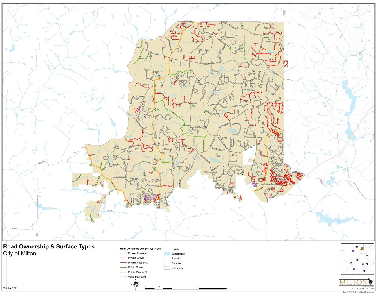
Urbanism. With respect to Form-Based Codes, the collective term for the condition of a compact, mixed use settlement, including the physical form of its development and its environmental, functional, economic, and sociocultural aspects.
Urbanized. With respect to Form-Based Codes, developed at T3 (Sub-Urban) density or higher.
Use. The purpose or function arranged or intended for a structure or property.
Use, accessory.
1.
With respect to the general provisions of this UDC, any use that is usually subordinate in both purpose and size, incidental to, and customarily associated with a permitted principal use located on the same lot.
2.
With respect to Sec. 8.5. Telecommunications, a tower and/or antenna is considered a principal use if located on any lot or parcel of land as the sole or primary structure, and is considered an accessory use if located on a lot or parcel shared with a different existing primary use or existing structure.
Use, principal. The primary or main purpose or function of a lot or structure. The term "principal" is synonymous with the terms "main" and "primary."
Use permit. A permit approved by the City Council, pursuant to a public hearing, which authorizes a use which must meet certain standards.
Utility permit. An official authorization issued by the Public Works Department, allowing the alteration of land within the right-of-way for the commencement of any construction activities pertaining to utility installation or relocation.
V
Variance.
1.
With respect to the general provisions of this UDC, a grant of relief from the requirements of this UDC which permits construction in a manner otherwise prohibited by this UDC. See Sec. 12.4 (Requests for Relief).
2.
With respect to Form-Based Codes, a ruling that would permit a practice that is not consistent with either a specific provision or the Intent of this code. Variances are processed as a primary variance by the Board of Zoning Appeals.
Variance, administrative. A request:
1.
For relief from the standards contained in Sec. 9.3 (Site Improvements), Article 10 (Streets and Improvements), or Article 11 (Environment), except when as otherwise provided for in the applicable section or article;
2.
To reduce the 10-foot improvement setback required along all buffers as required in the conditions of zoning; or
3.
For up to a 10% reduction in the number of required parking spaces per Sec. 9.1.3.E.
Variance, administrative minor. A variance to the minimum district yard requirements of not more than one foot, granted administratively by the Director.
Variance, concurrent. A request for a primary variance concurrently with a rezoning petition, modification or use permit.
Variance, minor. An application requesting deviation from the minimum yard requirements, not to exceed 10% of the dimensional requirements.
Variance, primary. An application requesting relief from the standards of this UDC, except relief from use, minimum lot area, or minimum lot frontage.
Variance, secondary. An appeal of variance decisions and interpretations made by the department director authorized to grant a variance request or interpretation of this UDC.
Vegetative erosion and sedimentation control measures. Measures for the stabilization of erodible or sediment-producing areas by covering the soil with:
1.
Permanent seeding, sprigging, or planting, producing long-term vegetative cover;
2.
Temporary seeding, producing short-term vegetative cover; or
3.
Sodding, covering areas with a turf of perennial sod-forming grass.
Such measures can be found in the publication Manual for Erosion and Sediment Control in Georgia.
Vegetative screen. An evergreen planting which, within three years of planting, provides a 100% visual barrier between a lot and adjacent lots and uses with a minimum height of 6 feet. A vegetative screen is composed of plant materials.
Violation. With respect to Sec. 11.2. Floodplain Management/Flood Damage Prevention, the failure of a structure or other development to be fully compliant with the community's floodplain management regulations. A structure or other development without the elevation certificate, other certificates, or other evidence of compliance required in Sec. 11.2. Floodplain Management/Flood Damage Prevention is presumed to be in violation until such time as that documentation is provided.
W
Wall sign. Any sign attached parallel to a wall, painted on the wall surface or erected and confined within the limits of an outside wall of any building or structure, which is supported by such wall or building and which displays only one sign surface.
Warrant. A ruling that would permit a practice that is not consistent with a specific provision of a Form-Based Code, but that is justified by its Intent. Warrants are processed as an administrative variance by the Director.
Waste. Materials that are discarded, disposed of or no longer usable.
Waste, hazardous. See the "Georgia Department of Natural Resources" definition.
Waste, solid. See the "Georgia Department of Natural Resources" definition.
Waste disposal boundary. The limit of all waste disposal areas, appurtenances, and ancillary activities including, but not limited to:
1.
Internal access roads; and
2.
Drainage control devices.
Waste haulers. Companies granted non-exclusive contracts to remove residential and commercial refuse and waste which includes items to be recycled.
Water feature. An artificial pond, artificial waterfall, artificial wetland, artificial stream, water foundation, or any other artificial design element that incorporates water. The term excludes naturally occurring hydrology.
Water surface elevation. The relationship between the projected heights and the NGVD reached by floods of various magnitudes and frequencies in the floodplains.
Water tower. A tower or standpipe serving as a reservoir to deliver water at a required head, whether in use, no longer in use or an architectural feature.
Watercourse. Any natural or artificial watercourse, stream, river, creek, channel, ditch, canal, conduit, culvert, drain, waterway, gully, ravine, or wash in which water flows either continuously or intermittently and which has a definite channel, bed, and banks, and including any area adjacent thereto subject to inundation by reason of overflow or floodwater.
Watershed. The land area that drains into a particular stream.
Wetlands. Those areas that are inundated or saturated by surface water or groundwater at a frequency and duration sufficient to support, and that under normal circumstances do support, a prevalence of vegetation typically adapted for life in saturated soil conditions. The term includes:
1.
Bogs.
2.
Marshes.
3.
Swamps.
4.
Similar areas.
Wild animal. Any animal which is not wildlife and is not normally a domestic species in this state. This term specifically includes any hybrid or cross between any combination of a wild animal, wildlife, and a domestic animal. Offspring from all subsequent generations of such crosses or hybrids are wild animals.
Wildlife. Any vertebrate or invertebrate animal life indigenous to this state or any species introduced or specified by the board and includes fish, except domestic fish produced by aquaculturists registered under O.C.G.A. § 27-4-255, mammals, birds, amphibians, reptiles, crustaceans, and mollusks or any part thereof.
Wing wall. A wall that extends from an exterior building wall and is architecturally structurally integrated into the design of the building to which it is attached.
Window sign. Any sign that is affixed to the exterior of the window or window panes, or affixed to the interior of the window or window panes or the sign is located within the structure and the message is reasonably discernable from the nearest public or private road. Window signs include decals and images painted onto the glass. Window signs do not include architectural features.
Wireless infrastructure provider. With respect to Sec. 8.4.4. Small Wireless Facilities and Antennas, any person, including a person authorized to provide telecommunications services in this state, that builds, installs, or operates small wireless facilities, poles, decorative poles, or support structures on which small wireless facilities are or are intended to be used for collocation but that is not a wireless services provider.
Wireless service provider. With respect to Sec. 8.4.5. Telecommunications Facility, any private or public entity engaged in the transfer of information over a distance without the use of electrical conductors.
Wireless provider. With respect to Sec. 8.4.4. Small Wireless Facilities and Antennas, a wireless infrastructure provider or a wireless services provider.
Wireless services. With respect to Sec. 8.4.4. Small Wireless Facilities and Antennas, any services provided to the public using licensed or unlicensed spectrum, including the use of Wi-Fi, whether at a fixed location or mobile.
Wireless services provider. With respect to Sec. 8.4.4. Small Wireless Facilities and Antennas, a person that provides wireless services.
Wireless telecommunications facility (WTF). With respect to Sec. 8.4.5. Telecommunications Facility, a staffed or unstaffed commercial facility for the transmission and/or reception of radio frequency signals, or other wireless communications, and usually consisting of an antenna or groups of antennas, transmission cables and equipment enclosures, and may include an antenna support structure. The following nonexclusive list is considered a wireless telecommunications facility: new and existing antenna support structures, replacement antenna support structures, collocations on existing antenna support structures, attached wireless telecommunications facilities and concealed wireless telecommunications facilities. Also see Sec. 8.4.5 (Telecommunications Facility).
Wireline backhaul facility. With respect to Sec. 8.4.4. Small Wireless Facilities and Antennas, an aboveground or underground wireline facility used to transport communications data from a telecommunications demarcation box associated with small wireless facility to a network.
Y
Yard. An open space on the same lot with a structure that extends between the structure and a lot line.
Yard, front. A yard abutting any street except the side street on a corner lot. Front yards extend the entire length of an abutting street from intersecting lot line to intersecting lot line. The front yard of corner lots is applied to the street which abuts the lot for the shortest distance.
Yard, minimum. The minimum distance between a building or specified structure and a lot line as specified in the district regulations.
Yard, rear. A yard between the rear lot line and a structure. True triangular lots do not have rear yards. Lots with more than one front lot line do not have rear yards. The Director makes the final determination of rear yards when in dispute or undefined by this definition.
Yard, side. A yard which is not a front or rear yard. The term includes a side corner yard unless otherwise indicated.
Yard, side corner. A yard along the side street on a corner lot.
Yield. With respect to Form-Based Codes, characterizing a thoroughfare that has two-way traffic but only one effective travel lane because of parked cars, necessitating slow movement and driver negotiation.
Z
Zero lot line. The location of a building on a lot in such a manner that one or more of the building's sides rest directly on a lot line, such as "patio homes" or "townhouses."
Zoned development. Property subject to a single zoning application.
Zoning conditions. The requirements placed on property by the City Council at the time of approval of a rezoning and use permit.
Zoning map. The Official Zoning Map of the City of Milton, Georgia.
Zoning modification. An application to change approved zoning conditions on rezonings and use permits where it has been determined by the Director that the requested change involves a matter of significant public interest. The term is synonymous with the term "modification."
Zoning ordinance.Articles 1 through 9, Article 12, as well as those definitions set forth in Article 13 that constitute, by reference, text of these articles, are all intended to constitute a zoning ordinance within the meaning of O.C.G.A. § 36-66-1, et seq.
(Ord. No. 25-05-578, § 1(Exh. A), 5-19-2025)

