
Milton City Zoning Code
ARTICLE 4
- RESIDENTIAL DISTRICTS
4.1.1. - Scope and Intent
This section contains the R-1 district regulations. The R-1 district encompasses lands devoted to residential areas and closely related uses.
4.1.2. - Uses
See Article 8.
4.1.3. - Dimensional Standards
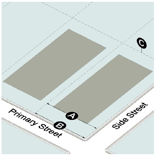 | |
| Lots | |
| Ⓐ Width: | 200 ft. min. |
| Ⓑ Frontage: | 35 ft. min. |
| Ⓒ Area: | 2 ac. min. |
4.1.4. - Building Placement
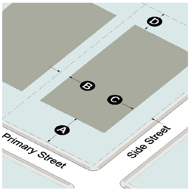 | |
| Ⓐ Front Yard: | 60 ft. min. |
| Ⓑ Side Yard (interior): | 25 ft. min. |
| Ⓒ Side Yard (Street: | 40 ft. min. |
| Ⓓ Rear Yard: | 50 ft. min. |
| Accessory Structure Setbacks | |
| Accessory structures may be located in rear or side yards but must not be located within a minimum yard. Additional standards may apply to specific accessory uses in Sec. 8.8. | |
4.1.5. - Bulk and Mass
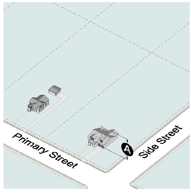 | |
| Building Height | |
| Ⓐ Single-Family Dwellings: | Per Sec. 6.3.3.B (Rural Milton Overlay) |
| Ⓐ Other Buildings: | 40 ft. max.[1] |
| Heated Floor Area | |
| Fewer Than Two-Story Dwelling: | 1,800 sf. min. on first story |
| Two-Story Dwelling: | 2,000 sf. min. |
| More Than Two-Story Dwelling: | 1,200 sf. min. on first story |
| Table note: | |
| [1] See Sec. 6.3 (Rural Milton Overlay) and Sec. 6.2.8.N (State Route 9 Overlay) for additional height limits. | |
4.1.6. - Entrances
Entrances from a public right-of-way for subdivisions with more than three lots must be rural, simple, and rustic in design, as determined by the City Architect, and must comply with the following:
A.
Signage
Signage must be one of the following designs:
1.
Shingle style.
2.
Sign mounted in or on pillar, provided the pillar must not exceed 8 feet high.
B.
Walls
1.
Knee walls may be utilized where required by existing topography and must not exceed 20 linear feet on either side of the subdivision's road entrance.
2.
Knee walls must be constructed of natural materials such as boulders, stacked stone, or wood formed brick or materials designed to give the appearance of such natural materials, as shown in Figures 4.1.6.A and 4.1.6.B. Stucco is prohibited.
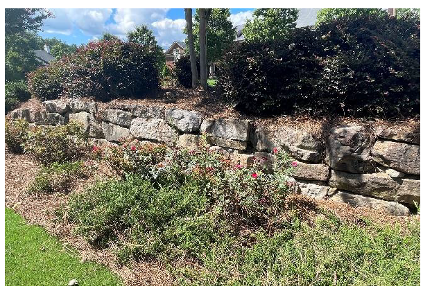
Figure 4.1.6.A
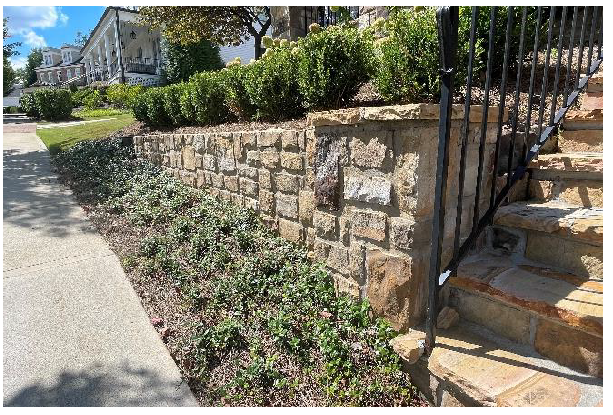
Figure 4.1.6.B
C.
Other Structures
Gate or guard structures must be set back at least 60 feet from exterior street rights-of-way.
D.
Water Features
Water features are not allowed.
4.1.7. - Rural Viewshed
A.
Applicability
This subsection only applies to subdivisions with more than three lots. The requirements of this subsection, except for Sec. 4.1.7.B.4, do not apply to a single lot of record or to subdivisions with three or fewer lots where no individual lot abuts an exterior street.
B.
Rural Viewshed Standards
1.
Applicable subdivisions must provide a 40-foot primary rural viewshed setback from all proposed Milton Trail or sidewalk easements or proposed rights-of-way, whichever is more restrictive, along the exterior streets for buildings, accessory structures, and swimming pools for lots adjacent to exterior streets:
a.
No disturbance within the 40-foot primary rural viewshed setback is allowed until a design review process is completed and the design of the rural viewshed is approved by the design committee.
b.
Driveways accessing exterior streets are prohibited within the 40-foot primary rural viewshed setback, except where they cross the rural viewshed in a perpendicular manner.
c.
Individual septic systems may be installed in the primary rural viewshed setback with an approved primary variance if the primary and secondary septic fields fail and the property may be condemned by the Fulton County Health Department without such variance. The property owner must provide proof of such potential condemnation prior to the application for a primary variance.
2.
Applicable subdivisions must also provide a 20-foot secondary rural viewshed setback from the primary rural viewshed setback for buildings, accessory structures, and swimming pools for lots adjacent to exterior streets.
a.
Individual septic systems may be installed in the secondary rural viewshed setback with an approved primary variance.
b.
Driveways accessing exterior streets are prohibited within the 20-foot secondary rural viewshed setback, except where they cross the rural viewshed in a perpendicular manner.
c.
No disturbance within the 20-foot secondary rural viewshed setback is allowed until a design review process is completed and the design of the rural viewshed is approved by the design committee.
3.
The intent of the rural viewshed is to preserve the bucolic views from the roads throughout the Rural Milton Overlay. The views may contain natural vegetation as well as equestrian related structures and uses. It is the intent to utilize the existing vegetation when possible as well as provide additional native plantings to enhance the existing viewshed when needed.
a.
When performing a design review of the primary rural viewshed and secondary rural viewshed setbacks, the design committee must address the following:
i.
Evaluation of current state of site including vegetation, both the primary and secondary rural viewshed setbacks.
ii.
Determination of whether existing vegetation should be removed or vegetation should be planted to enhance the rural viewshed.
iii.
Consideration of whether screening of the structures is necessary.
iv.
Consideration of the existence of open uses defined in Sec. 8.7 (Open Uses) in the area.
4.
For structures located on lots subject to a rural viewshed, an architectural review process is required. Such process will include a review of building elevations and landscape plans by the City Architect. These structures must be designed with 360-degree architecture and must meet the intent of Sec. 6.3.10 (Characteristics of Rural Milton Overlay).
5.
After the City issues the necessary permits to disturb the property, but before the required pre-construction meeting, the developer must install a 4 feet high orange tree save fence at least at the combined primary rural viewshed and secondary rural viewshed setback measured from the proposed Milton Trail or sidewalk easement or the proposed right-of-way. The fence must be installed so as to protect heritage trees, protected trees, and specimen trees as defined in Sec. 11.1 Tree Canopy Conservation or any other significant vegetation as determined by the City Arborist. The appropriate location of such fencing must be approved by the City Arborist. In addition, a sign must be posted on the fence every 25 feet indicating "rural viewshed." The tree save fence must be removed when the issuance of a certificate of occupancy for each lot abutting the viewshed is issued.
6.
Notwithstanding anything to the contrary in this subsection, agricultural operations (see Sec. 8.7.1.B) may occur in the primary rural viewshed and secondary rural viewshed setbacks.
7.
Before transfer of any legal interest in an R-1 zoned parcel that is subject to a rural viewshed, every legal or beneficial owner of such a parcel must ensure that there is recorded in the chain of title for the parcel an affidavit stating the following:
"At the time of the execution of this Affidavit, the property with respect to which this Affidavit is filed is subject to certain restrictions contained in the Unified Development Code for the City of Milton, Georgia. Such restrictions may include restrictions on development and disturbance of property located in the rural viewshed, which includes portions of property adjacent to streets not located within a platted subdivision."
In addition, a copy of the affidavit must be provided to any transferee of a legal interest in the parcel no later than the final closing of the transfer.
C.
Architectural Review of Structures
The following requirements are for structures located on a single lot of record or a subdivision with fewer than four lots that abut an exterior street:
1.
An architectural review process is required and must include a review of building elevations and landscape plans by the City Architect.
2.
These structures must be designed with street elevation architecture and must meet the intent of Sec. 6.3.10 (Characteristics of Rural Milton Overlay).
D.
Violations and Penalties
For any disturbance of the rural viewshed before the appropriate approvals are issued, the property will be barred from being developed for three years following issuance of the notice of violation and must restore the land to its original landscape or if applicable with appropriate tree recompense as determined by the City Arborist.
4.1.8. - Fencing
A.
Height and Style
Fences must meet the standards of Sec. 2.3.2.E.
B.
Barbed Wire
Barbed wire is prohibited on any lots, except when part of an agriculture use defined in Sec. 8.7.1 (Agriculture).
C.
Setbacks
Fences and walls must be set back at least 3 feet from a public right-of-way.
4.1.9. - Overlay Compliance
Additional or alternative standards may apply within overlay districts.
A.
State Route 9 Overlay
See Sec. 6.2.
B.
Rural Milton Overlay
See Sec. 6.3.
4.2.1. - Scope and Intent
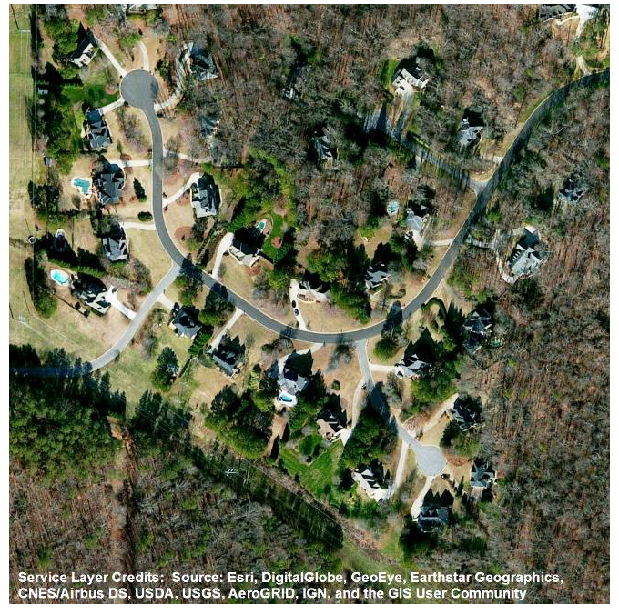
This section contains the R-2 district regulations. The R-2 district is intended to provide land areas devoted to residential uses. The district also provides for closely related uses.
4.2.2. - Uses
See Article 8.
4.2.3. - Dimensional Standards
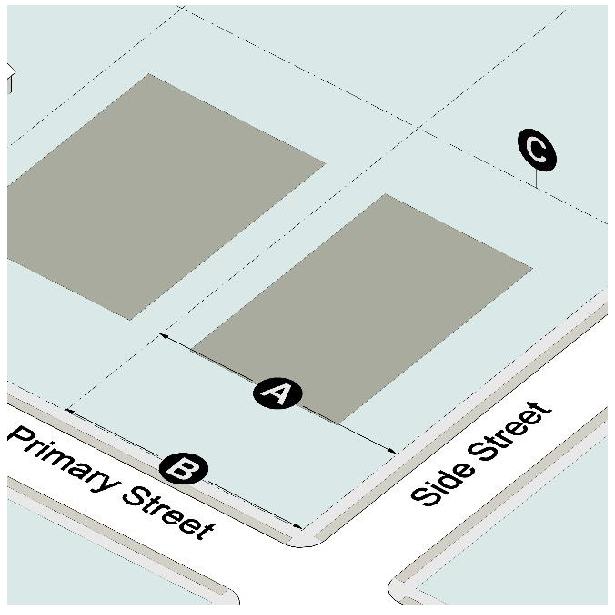 | |
| Lots | |
| Ⓐ Width: | 150 ft. min. |
| Ⓑ Frontage: | 35 ft. min. |
| Ⓒ Area: | 1 ac. min. |
4.2.4. - Building Placement
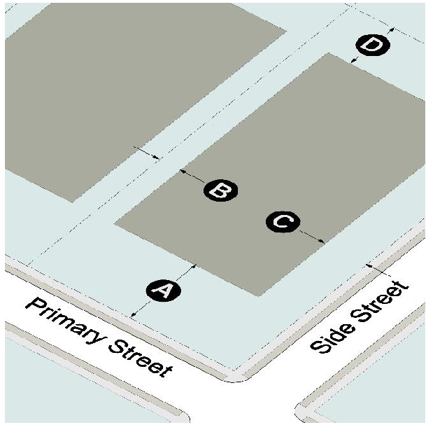 | |
| Principal Building Setbacks | |
| Ⓐ Front Yard: | 60 ft. min. |
| Ⓑ Side Yard (interior): | 15 ft. min. |
| Ⓒ Side Yard (street): | 30 ft. min. |
| Ⓓ Rear Yard: | 40 ft. min. |
| Accessory Structure Setbacks | |
| Accessory structures may be located in rear or side yards but shall not be located in a minimum yard. Additional standards may apply to specific accessory uses in Sec. 8.8 (Accessory Uses). | |
4.2.5. - Bulk and Mass
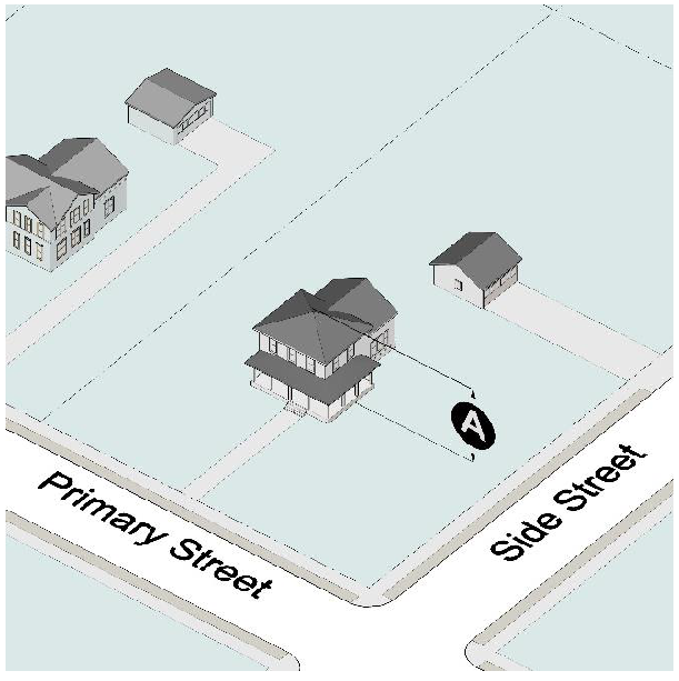 | |
| Building Height | |
| Ⓐ All Buildings: | 40 ft. max.[1] |
| Heated Floor Area | |
| Fewer Than Two-Story Dwelling: | 1,600 sf. min. on first story |
| Two-Story Dwelling: | 1,800 sf. min. |
| More Than Two-Story Dwelling: | 1,800 sf. min. with 1,050 sf. min. on first story |
| Table note: | |
| [1] See Sec. 6.3 (Rural Milton Overlay) and Sec. 6.2.8.N (State Route 9 Overlay) for additional height limits. | |
4.2.6. - Entrances
Entrances from a public right-of-way for subdivisions with more than three lots must be rural, simple, and rustic in design, as determined by the City Architect, and must comply with the following:
A.
Signage
Signage must be one of the following designs:
1.
Shingle style.
2.
Sign mounted in or on pillar, provided the pillar must not exceed 8 feet high.
B.
Walls
1.
Knee walls may be utilized where required by existing topography and must not exceed 20 linear feet on either side of the subdivision's road entrance.
2.
Knee walls must be constructed of natural materials such as boulders, stacked stone, or wood formed brick or materials designed to give the appearance of such natural materials, as shown in Figures 4.2.6.A and 4.2.6.B. Stucco is prohibited.
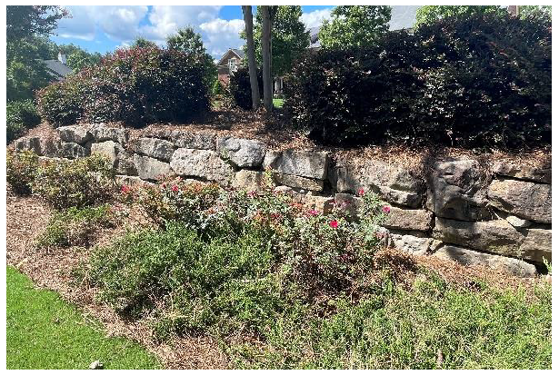
Figure 4.2.6.A
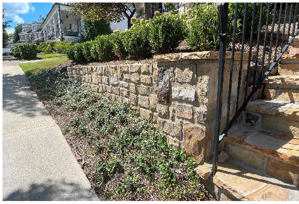
Figure 4.2.6.B
C.
Other Structures
Gate or guard structures must be set back at least 60 feet from exterior street rights-of-way.
D.
Water Features
Water features are not allowed.
4.2.7. - Rural Viewshed
A.
Applicability
This subsection only applies to subdivisions with more than three lots. The requirements of this subsection, except for Sec. 4.2.7.B.4, do not apply to a single lot of record or to subdivisions with three or fewer lots where no individual lot abuts an exterior street.
B.
Rural Viewshed Standards
1.
Applicable subdivisions must provide a 40-foot primary rural viewshed setback from all proposed Milton Trail or sidewalk easements or proposed rights-of-way, whichever is more restrictive, along the exterior streets for buildings, accessory structures, and swimming pools for lots adjacent to exterior streets:
a.
No disturbance within the 40-foot primary rural viewshed setback is allowed until a design review process is completed and the design of the rural viewshed is approved by the design committee.
b.
Driveways accessing exterior streets are prohibited within the 40-foot primary rural viewshed setback, except where they cross the rural viewshed in a perpendicular manner.
c.
Individual septic systems may be installed in the primary rural viewshed setback with an approved primary variance if the primary and secondary septic fields fail and the property may be condemned by the Fulton County Health Department without such variance. The property owner must provide proof of such potential condemnation prior to the application for a primary variance.
2.
Applicable subdivisions must also provide a 20-foot secondary rural viewshed setback from the primary rural viewshed setback for buildings, accessory structures, and swimming pools for lots adjacent to exterior streets.
a.
Individual septic systems may be installed in the secondary rural viewshed setback with an approved primary variance.
b.
Driveways accessing exterior streets are prohibited within the 20-foot secondary rural viewshed setback, except where they cross the rural viewshed in a perpendicular manner.
c.
No disturbance within the 20-foot secondary rural viewshed setback is allowed until a design review process is completed and the design of the rural viewshed is approved by the design committee.
3.
The intent of the rural viewshed is to preserve the bucolic views from the roads throughout the Rural Milton Overlay. The views may contain natural vegetation as well as equestrian related structures and uses. It is the intent to utilize the existing vegetation when possible as well as provide additional native plantings to enhance the existing viewshed when needed.
a.
When performing a design review of the primary rural viewshed and secondary rural viewshed setbacks, the design committee must address the following:
i.
Evaluation of current state of site including vegetation, both the primary and secondary rural viewshed setbacks.
ii.
Determination of whether existing vegetation should be removed or vegetation should be planted to enhance the rural viewshed.
iii.
Consideration of whether screening of the structures is necessary.
iv.
Consideration of the existence of open uses defined in Sec. 8.7 (Open Uses) in the area.
4.
For structures located on lots subject to a rural viewshed, an architectural review process is required. Such process will include a review of building elevations and landscape plans by the City Architect. These structures must be designed with 360-degree architecture and must meet the intent of Sec. 6.3.10 (Characteristics of Rural Milton Overlay).
5.
After the City issues the necessary permits to disturb the property, but before the required pre-construction meeting, the developer must install a 4 feet high orange tree save fence at least at the combined primary rural viewshed and secondary rural viewshed setback measured from the proposed Milton Trail or sidewalk easement or the proposed right-of-way. The fence must be installed so as to protect heritage trees, protected trees, and specimen trees as defined in Sec. 11.1 Tree Canopy Conservation or any other significant vegetation as determined by the City Arborist. The appropriate location of such fencing must be approved by the City Arborist. In addition, a sign must be posted on the fence every 25 feet indicating "rural viewshed." The tree save fence must be removed when the issuance of a certificate of occupancy for each lot abutting the viewshed is issued.
6.
Notwithstanding anything to the contrary in this subsection, agricultural operations (see Sec. 8.7.1.B) may occur in the primary rural viewshed and secondary rural viewshed setbacks.
7.
Before transfer of any legal interest in an R-2 zoned parcel that is subject to a rural viewshed, every legal or beneficial owner of such a parcel must ensure that there is recorded in the chain of title for the parcel an affidavit stating the following:
"At the time of the execution of this Affidavit, the property with respect to which this Affidavit is filed is subject to certain restrictions contained in the Unified Development Code for the City of Milton, Georgia. Such restrictions may include restrictions on development and disturbance of property located in the rural viewshed, which includes portions of property adjacent to streets not located within a platted subdivision."
In addition, a copy of the affidavit must be provided to any transferee of a legal interest in the parcel no later than the final closing of the transfer.
C.
Architectural Review of Structures
The following requirements are for structures located on a single lot of record or a subdivision with fewer than four lots that abut an exterior street:
1.
An architectural review process is required and must include a review of building elevations and landscape plans by the City Architect.
2.
These structures must be designed with street elevation architecture and must meet the intent of Sec. 6.3.10 (Characteristics of Rural Milton Overlay).
D.
Violations and Penalties
For any disturbance of the rural viewshed before the appropriate approvals are issued, the property will be barred from being developed for three years following issuance of the notice of violation and must restore the land to its original landscape or if applicable with appropriate tree recompense as determined by the City Arborist.
4.2.8. - Fencing
A.
Height and Style
Fences must meet the standards of Sec. 2.3.2.E.
B.
Barbed Wire
Barbed wire is prohibited on any lots, except when part of an agriculture use defined in Sec. 8.7.1 (Agriculture).
C.
Setbacks
Fences and walls must be set back at least 3 feet from a public right-of-way.
4.2.9. - Overlay Compliance
Additional or alternative standards may apply within overlay districts.
A.
State Route 9 Overlay
See Sec. 6.2.
B.
Rural Milton Overlay
See Sec. 6.3.
4.3.1. - Scope and Intent
This section contains the R-2A district regulations. The R-2A district is intended to provide land areas devoted to residential uses. The district also provides for closely related uses.
4.3.2. - Uses
See Article 8.
4.3.3. - Dimensional Standards
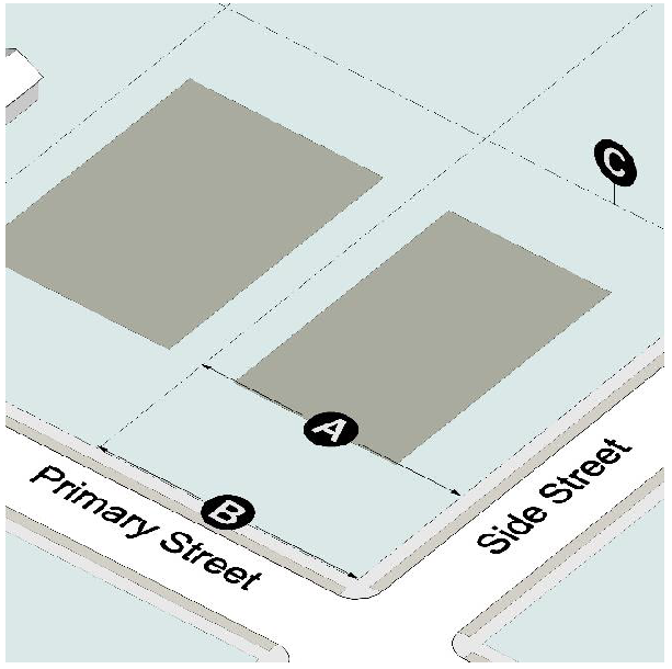 | |
| Lots | |
| Ⓐ Width: | 120 ft. min. |
| Ⓑ Frontage: | 35 ft. min. |
| Ⓒ Area: | 27,000 sf. min. |
4.3.4. - Building Placement
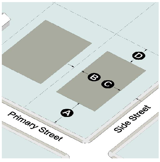 | |
| Principal Building Setbacks | |
| Ⓐ Front Yard: | 60 ft. min. |
| Ⓑ Side Yard (interior): | 15 ft. min. |
| Ⓒ Side Yard Street: | 30 ft. min. |
| Ⓓ Rear Yard; | 40 ft. min. |
| Accessory Structure Setbacks | |
| Accessory structures may be located in rear or side yards but must not be located in a minimum yard. Additional standards may apply to specific accessory uses in Sec. 8.8. | |
4.3.5. - Bulk and Mass
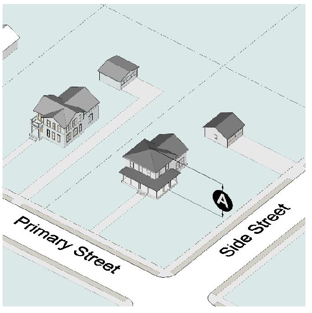 | |
| Ⓐ Single-family Dwellings: | Per Sec. 6.3.3.B (Rural Milton Overlay) |
| Ⓐ Other Buildings: | 40 ft. max.[1] |
| Heated Floor Area | |
| Fewer Than Two-Story Dwelling: | 1,700 sf. min. on first story |
| Two-Story Dwelling: | 1,800 sf. min. |
| More Than Two-Story Dwelling: | 1,800 sf. min. with 1,050 sf. min. on first story |
| Table note: | |
| [1] See Sec. 6.3 (Rural Milton Overlay) and Sec. 6.2.8.N (State Route 9 Overlay) for additional height limits. | |
4.3.6. - Entrances
Entrances from a public right-of-way for subdivisions with more than three lots must be rural, simple, and rustic in design, as determined by the City Architect, and must comply with the following:
A.
Signage
Signage must be one of the following designs:
1.
Shingle style.
2.
Sign mounted in or on pillar, provided the pillar must not exceed 8 feet high.
B.
Walls
1.
Knee walls may be utilized where required by existing topography and must not exceed 20 linear feet on either side of the subdivision's road entrance.
2.
Knee walls must be constructed of natural materials such as boulders, stacked stone, or wood formed brick or materials designed to give the appearance of such natural materials, as shown in Figures 4.3.6.A and 4.3.6.B. Stucco is prohibited.
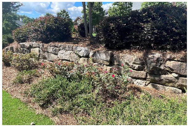
Figure 4.3.6.A
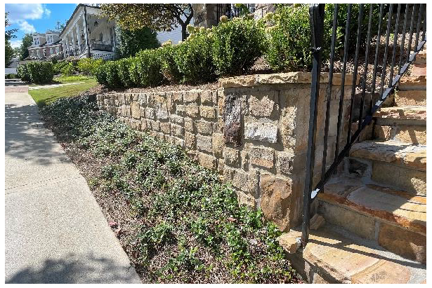
Figure 4.3.6.B
C.
Other Structures
Gate or guard structures must be set back at least 60 feet from exterior street rights-of-way.
D.
Water Features
Water features are not allowed.
4.3.7. - Rural Viewshed
A.
Applicability
This subsection only applies to subdivisions with more than three lots. The requirements of this subsection, except for Sec. 4.3.7.B.4, do not apply to a single lot of record or to subdivisions with three or fewer lots where no individual lot abuts an exterior street.
B.
Rural Viewshed Standards
1.
Applicable subdivisions must provide a 40-foot primary rural viewshed setback from all proposed Milton Trail or sidewalk easements or proposed rights-of-way, whichever is more restrictive, along the exterior streets for buildings, accessory structures, and swimming pools for lots adjacent to exterior streets:
a.
No disturbance within the 40-foot primary rural viewshed setback is allowed until a design review process is completed and the design of the rural viewshed is approved by the design committee.
b.
Driveways accessing exterior streets are prohibited within the 40-foot primary rural viewshed setback, except where they cross the rural viewshed in a perpendicular manner.
c.
Individual septic systems may be installed in the primary rural viewshed setback with an approved primary variance if the primary and secondary septic fields fail and the property may be condemned by the Fulton County Health Department without such variance. The property owner must provide proof of such potential condemnation prior to the application for a primary variance.
2.
Applicable subdivisions must also provide a 20-foot secondary rural viewshed setback from the primary rural viewshed setback for buildings, accessory structures, and swimming pools for lots adjacent to exterior streets.
a.
Individual septic systems may be installed in the secondary rural viewshed setback with an approved primary variance.
b.
Driveways accessing exterior streets are prohibited within the 20-foot secondary rural viewshed setback, except where they cross the rural viewshed in a perpendicular manner.
c.
No disturbance within the 20-foot secondary rural viewshed setback is allowed until a design review process is completed and the design of the rural viewshed is approved by the design committee.
3.
The intent of the rural viewshed is to preserve the bucolic views from the roads throughout the Rural Milton Overlay. The views may contain natural vegetation as well as equestrian related structures and uses. It is the intent to utilize the existing vegetation when possible as well as provide additional native plantings to enhance the existing viewshed when needed.
a.
When performing a design review of the primary rural viewshed and secondary rural viewshed setbacks, the design committee must address the following:
i.
Evaluation of current state of site including vegetation, both the primary and secondary rural viewshed setbacks.
ii.
Determination of whether existing vegetation should be removed or vegetation should be planted to enhance the rural viewshed.
iii.
Consideration of whether screening of the structures is necessary.
iv.
Consideration of the existence of open uses defined in Sec. 8.7 (Open Uses) in the area.
4.
For structures located on lots subject to a rural viewshed, an architectural review process is required. Such process will include a review of building elevations and landscape plans by the City Architect. These structures must be designed with 360-degree architecture and must meet the intent of Sec. 6.3.10 (Characteristics of Rural Milton Overlay).
5.
After the City issues the necessary permits to disturb the property, but before the required pre-construction meeting, the developer must install a 4 feet high orange tree save fence at least at the combined primary rural viewshed and secondary rural viewshed setback measured from the proposed Milton Trail or sidewalk easement or the proposed right-of-way. The fence must be installed so as to protect heritage trees, protected trees, and specimen trees as defined in Sec. 11.1 Tree Canopy Conservation or any other significant vegetation as determined by the City Arborist. The appropriate location of such fencing must be approved by the City Arborist. In addition, a sign must be posted on the fence every 25 feet indicating "rural viewshed." The tree save fence must be removed when the issuance of a certificate of occupancy for each lot abutting the viewshed is issued.
6.
Notwithstanding anything to the contrary in this subsection, agricultural operations (see Sec. 8.7.1.B) may occur in the primary rural viewshed and secondary rural viewshed setbacks.
7.
Before transfer of any legal interest in an R-2A zoned parcel that is subject to a rural viewshed, every legal or beneficial owner of such a parcel must ensure that there is recorded in the chain of title for the parcel an affidavit stating the following:
"At the time of the execution of this Affidavit, the property with respect to which this Affidavit is filed is subject to certain restrictions contained in the Unified Development Code for the City of Milton, Georgia. Such restrictions may include restrictions on development and disturbance of property located in the rural viewshed, which includes portions of property adjacent to streets not located within a platted subdivision."
In addition, a copy of the affidavit must be provided to any transferee of a legal interest in the parcel no later than the final closing of the transfer.
C.
Architectural Review of Structures
The following requirements are for structures located on a single lot of record or a subdivision with fewer than four lots that abut an exterior street:
1.
An architectural review process is required and must include a review of building elevations and landscape plans by the City Architect.
2.
These structures must be designed with street elevation architecture and must meet the intent of Sec. 6.3.10 (Characteristics of Rural Milton Overlay).
D.
Violations and Penalties
For any disturbance of the rural viewshed before the appropriate approvals are issued, the property will be barred from being developed for three years following issuance of the notice of violation and must restore the land to its original landscape or if applicable with appropriate tree recompense as determined by the City Arborist.
4.3.8. - Fencing
A.
Height and Style
Fences must meet the standards of Sec. 2.3.2.E.
B.
Barbed Wire
Barbed wire is prohibited on any lots, except when part of an agriculture use defined in Sec. 8.7.1 (Agriculture).
C.
Setbacks
Fences and walls must be set back at least 3 feet from a public right-of-way.
4.3.9. - Overlay Compliance
Additional or alternative standards may apply within overlay districts.
A.
State Route 9 Overlay
See Sec. 6.2.
B.
Rural Milton Overlay
See Sec. 6.3.
4.4.1. - Scope and Intent
This section contains the R-3 district regulations. The R-3 district is intended to provide land areas devoted to residential uses. The district also provides for closely related uses.
4.4.2. - Uses
See Article 8.
4.4.3. - Dimensional Standards
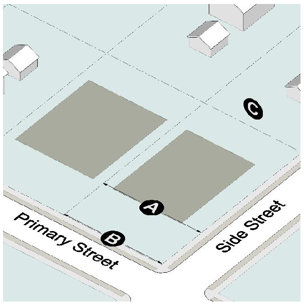 | |
| Lots | |
| Ⓐ Width: | 100 ft. min. |
| Ⓑ Frontage: | 35 ft. min. |
| Ⓒ Area: | 18,000 sf. min. |
4.4.4. - Building Placement
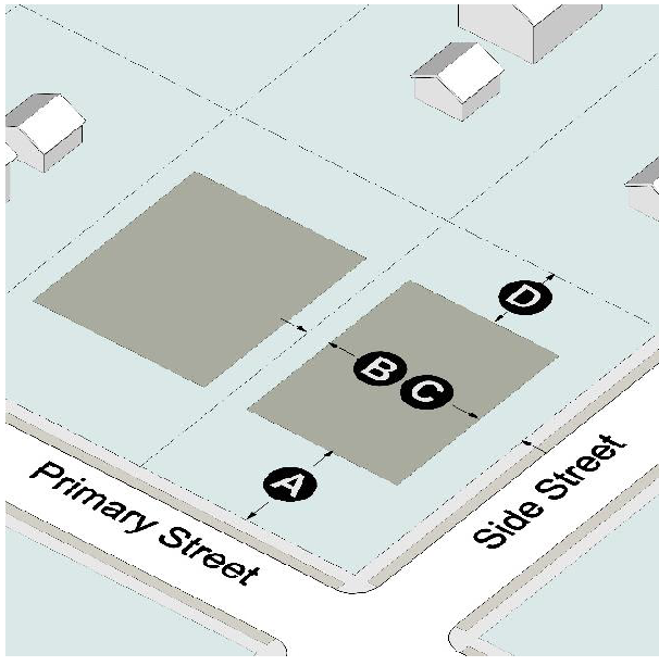 | |
| Principal Building Setbacks | |
| Ⓐ Front Yard: | 50 ft. min. |
| Ⓑ Side Yard (interior): | 10 ft. min. |
| Ⓒ Side Yard (street): | 20 ft. min. |
| Ⓓ Rear Yard: | 35 ft. min. |
| Accessory Structure Setbacks | |
| Accessory structures may be located in rear or side yards but must not be located within a minimum yard. Additional standards may apply to specific accessory uses in Sec. 8.8. | |
4.4.5. - Bulk and Mass
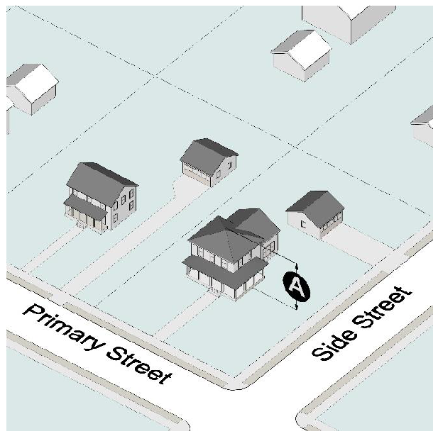 | |
| Building Height | |
| Ⓐ All Buildings: | 40 ft. max. [1] |
| Heated Floor Area | |
| Fewer Than Two-Story Dwelling: | 1,200 sf. min. on ground level |
| Two-Story Dwelling: | 1,320 sf. min. |
| More Than Two-Story Dwelling: | 1,320 sf. min. with 900 sf. min. on first story |
| Table note: | |
| [1] See Sec. 6.3 (Rural Milton Overlay) and Sec. 6.2.8.N (State Route 9 Overlay) for additional height limits. | |
4.4.6. - Overlay Compliance
Additional or alternative standards may apply within overlay districts.
A.
State Route 9 Overlay
See Sec. 6.2.
B.
Rural Milton Overlay
See Sec. 6.3.
4.5.1. - Scope and Intent
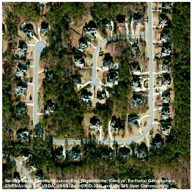
This section contains the R-3A district regulations. The R-3A district is intended to provide land areas devoted to residential uses. The district also provides for closely related uses.
4.5.2. - Uses
See Article 8.
4.5.3. - Dimensional Standards
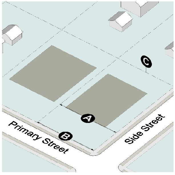 | |
| Lots | |
| Ⓐ Width: | 100 ft. min. |
| Ⓑ Frontage: | 35 ft. min. |
| Ⓒ Area: | 18,000 sf. min. |
4.5.4. - Building Placement
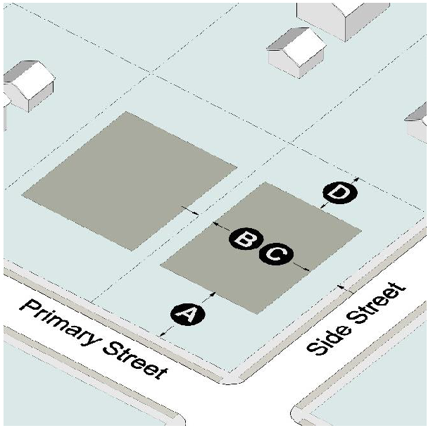 | |
| Principal Building Setbacks | |
| Ⓐ Front Yard: | 50 ft. min. |
| Ⓑ Side Yard (interior): | 10 ft. min. |
| Ⓒ Side Yard (street): | 20 ft. min. |
| Ⓓ Rear Yard: | 35 ft. min. |
| Accessory Structure Setbacks | |
| Accessory structures may be located in rear or side yards but must not be located within a minimum yard. Additional standards may apply to specific accessory uses in Sec. 8.8. | |
4.5.5. - Bulk and Mass
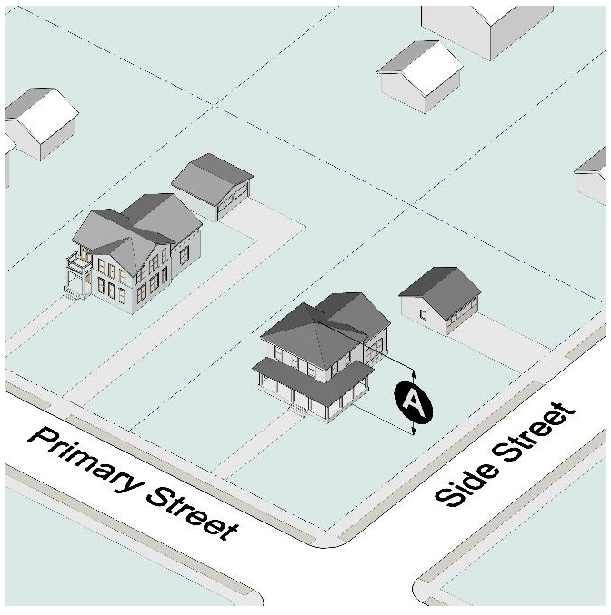 | |
| Building Height | |
| Ⓐ All Buildings: | 40 ft. max. [1] |
| Heated Floor Area | |
| Fewer Than Two-story Dwelling: | 1,600 sf. min. on first story |
| Two-story Dwelling: | 1,800 sf. min. |
| More Than Two-story Dwelling: | 1,800 sf. min. with 1,050 sf. min. on first story |
| Table note: | |
| [1] See Sec. 6.3 (Rural Milton Overlay) and Sec. 6.2.8.N (State Route 9 Overlay) for additional height limits. | |
4.5.6. - Overlay Compliance
Additional or alternative standards may apply within overlay districts.
A.
State Route 9 Overlay
See Sec. 6.2.
B.
Rural Milton Overlay
See Sec. 6.3.
4.6.1. - Scope and Intent
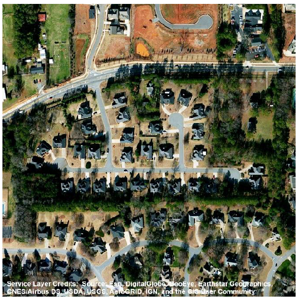
This section contains the R-4 district regulations. The R-4 district is intended to provide land areas devoted to residential uses. The district also provides for closely related uses.
4.6.2. - Uses
See Article 8.
4.6.3. - Dimensional Standards
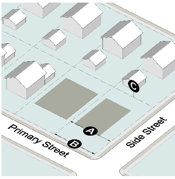 | |
| Lots | |
| Ⓐ Width | 70 ft. min. |
| Ⓑ Frontage | 35 ft. min. |
| Ⓒ Area | 9,000 sf. min. |
4.6.4. - Building Placement
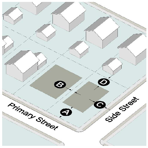 | |
| Principal Building Setbacks | |
| Ⓐ Front Yard: | 35 ft. min. |
| Ⓑ Side Yard (interior): | 7 ft. min. |
| Ⓒ Side Yard (street): | 20 ft. min. |
| Ⓓ Rear Yard: | 25 ft. min. |
| Accessory Structure Setbacks | |
| Accessory structures may be located in rear or side yards but must not be located within a minimum yard. Additional standards may apply to specific accessory uses in Sec. 8.8. | |
4.6.5. - Bulk and Mass
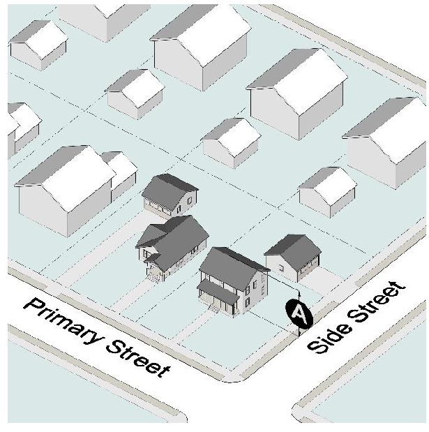 | |
| Building Height | |
| Ⓐ All Buildings: | 40 ft. max.[1] |
| Heated Floor Area | |
| Fewer Than Two-Story Dwelling: | 1,000 sf. min. on first story |
| Two-Story Dwelling: | 1,100 sf. min. |
| More Than Two-Story Dwelling: | 1,100 sf. min. with 800 sf. min. on first story |
| Table note: | |
| [1] See Sec. 6.3 (Rural Milton Overlay) and Sec. 6.2.8.N (State Route 9 Overlay) for additional height limits. | |
4.6.6. - Overlay Compliance
Additional or alternative standards may apply within overlay districts.
A.
State Route 9 Overlay
See Sec. 6.2.
B.
Rural Milton Overlay
See Sec. 6.3.
4.7.1. - Scope and Intent
This section contains the R-4A district regulations. The R-4A district is intended to provide land areas devoted to residential uses. The district also provides for closely related uses.
4.7.2. - Uses
See Article 8.
4.7.3. - Dimensional Standards
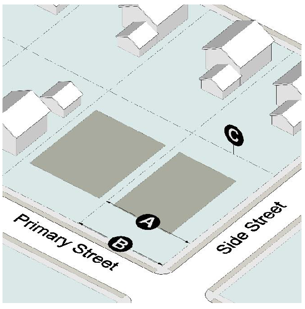 | |
| Lots | |
| Ⓐ Width: | 85 ft. min. |
| Ⓑ Frontage: | 35 ft. min. |
| Ⓒ Area: | 12,000 sf. min. |
4.7.4. - Building Placement
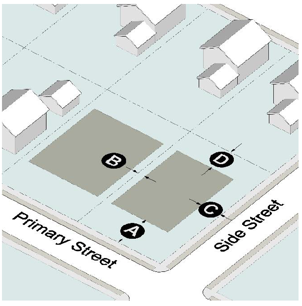 | |
| Principal Building Setbacks | |
| Ⓐ Front Yard: | 35 ft. min. |
| Ⓑ Side Yard (interior): | 7 ft. min. |
| Ⓒ Side Yard (street): | 20 ft. min. |
| Ⓓ Rear Yard: | 25 ft. min. |
| Accessory Structure Setbacks | |
| Accessory structures may be located in rear or side yards but must not be located within a minimum yard. Additional standards may apply to specific accessory uses in Sec. 8.8. | |
4.7.5. - Bulk and Mass
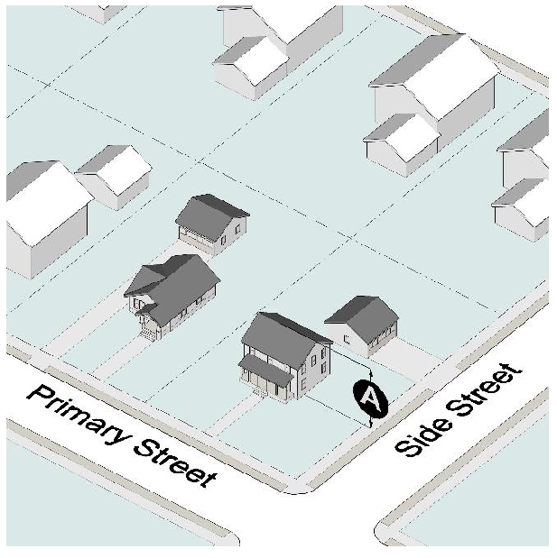 | |
| Building Height | |
| Ⓐ All Buildings: | 40 ft. max.[1] |
| Heated Floor Area | |
| Fewer Than Two-Story Dwelling: | 1,200 sf. min. on first story |
| Two-Story Dwelling: | 1,320 sf. min. |
| More Than Two-Story dwelling: | 1,320 sf. min. with 900 sf. min. on first story |
| Table note: | |
| [1] See Sec. 6.3 (Rural Milton Overlay) and Sec. 6.2.8.N (State Route 9 Overlay) for additional height limits. | |
4.7.6. - Overlay Compliance
Additional or alternative standards may apply within overlay districts.
A.
State Route 9 Overlay
See Sec. 6.2.
B.
Rural Milton Overlay
See Sec. 6.3.
4.8.1. - Scope and Intent
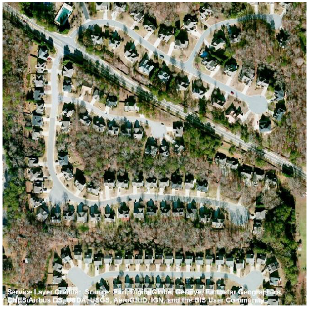
This section contains the R-5 district regulations. The R-5 district is intended to provide land areas devoted to dwelling uses. Areas zoned R-5 are further intended to only occur adjacent to higher density residential, commercial, or mixed-use zoning districts and in accordance with the Comprehensive Plan.
4.8.2. - Uses
See Article 8.
4.8.3. - Dimensional Standards
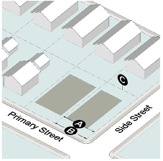 | |
| Lots | |
| Ⓐ Width: | 60 ft. min. |
| Ⓑ Frontage: | 35 ft. min. |
| Ⓒ Area: | 7,500 sf. min. |
4.8.4. - Building Placement
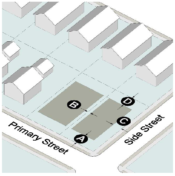 | |
| Principal Building Setbacks | |
| Ⓐ Front Yard: | 20 ft. min. |
| Ⓑ Side Yard (interior): | 5 ft. min. |
| Ⓒ Side Yard (street): | 15 ft. min. |
| Ⓓ Rear Yard: | 20 ft. min. |
| Accessory Structure Setbacks | |
| Accessory structures may be located in rear or side yards but must not be located within a minimum yard. Additional standards may apply to specific accessory uses in Sec. 8.8. | |
4.8.5. - Bulk and Mass
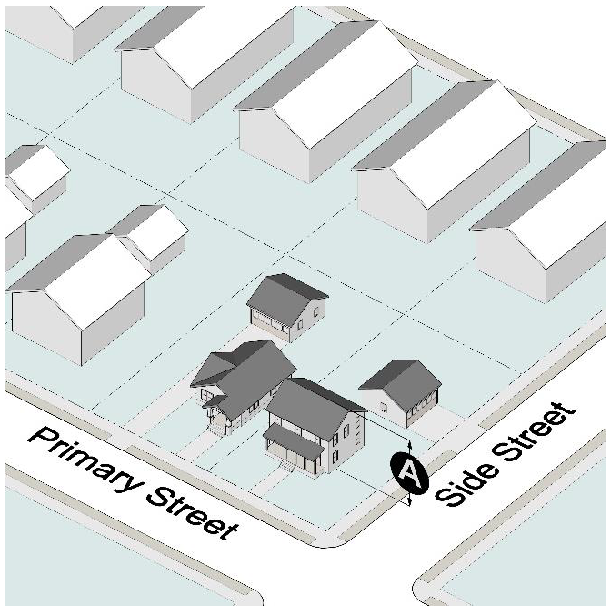 | |
| Building Height | |
| Ⓐ All Buildings: | See Sec. 6.2.8.N (State Route 9 Overlay) |
| Heated Floor Area | |
| All Dwellings: | 650 sf. min. |
4.8.6. - Overlay Compliance
Additional or alternative standards may apply within overlay districts.
A.
State Route 9 Overlay
See Sec. 6.2.
B.
Rural Milton Overlay
See Sec. 6.3.
4.9.1. - Scope and Intent
This section contains the R-5A district regulations. The R-5A district is intended to provide land areas devoted to medium density, single-family dwellings. Areas zoned R-5A are further intended to only occur adjacent to higher density residential, commercial, or mixed-use zoning districts and in accordance with the Comprehensive Plan.
4.9.2. - Uses
See Article 8.
4.9.3. - Dimensional Standards
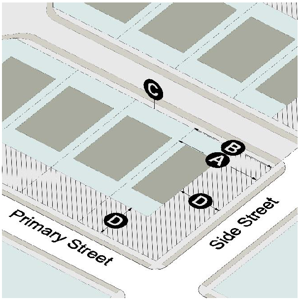 | |
| Lots | |
| Ⓐ Width: | No min. |
| Ⓑ Frontage: | 20 ft. min |
| Ⓒ Area: | 4,000 sf. min. |
| Site | |
| Ⓓ Perimeter Setback (all yards): | 40 ft. min. |
4.9.4. - Building Placement
| |
| Principal Building Setbacks | |
| Ⓐ Front Yard: | 20 ft. min. |
| Ⓑ Side Yard (interior): | 0 ft. min. [1] [2] |
| Ⓒ Side Yard (street): | 20 ft. min. |
| Ⓓ Rear Yard: | 20 ft. min. |
| Accessory Structure Setbacks | |
| Accessory structures may be located in rear or side yards but must not be located within a minimum rear yard, except that detached garages may be located within a minimum rear yard with an encroachment and maintenance easement [2]. Additional standards may apply to specific accessory uses in Sec. 8.8. | |
| Interior Building Separation | |
| At least 14 feet of building separation is required, unless more separation is specified by the City's building code. | |
| Table note: | |
| [1] To place a building along an interior side lot line at between zero and 7 feet requires an encroachment and maintenance easement. | |
| [2] Easements must be at least 7 feet wide and must be provided on the immediately adjacent parcel. | |
4.9.5. - Bulk and Mass
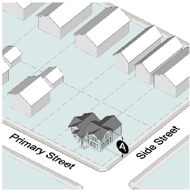 | |
| Building Height | |
| Ⓐ All Buildings: | 40 ft. max. [1] |
| Heated Floor Area | |
| All Dwellings: | 850 sf. min. |
| Table note: | |
| [1] See Sec. 6.3 (Rural Milton Overlay) and Sec. 6.2.8.N (State Route 9 Overlay) for additional height limits. | |
4.9.6. - Overlay Compliance
Additional or alternative standards may apply within overlay districts.
A.
State Route 9 Overlay
See Sec. 6.2.
B.
Rural Milton Overlay
See Sec. 6.3.
4.10.1. - Scope and Intent
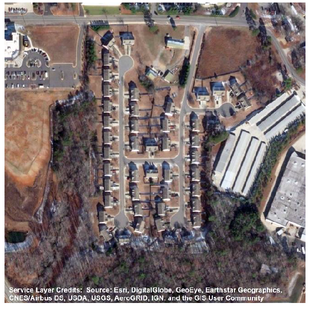
This section contains the R-6 district regulations. The R-6 district is intended to provide land areas devoted to medium density, single-family and two-family dwellings. Areas zoned R-6 are further intended to only occur adjacent to higher density residential, commercial, or mixed-use zoning districts and in accordance with the Comprehensive Plan.
4.10.2. - Uses
See Article 8.
4.10.3. - Dimensional Standards
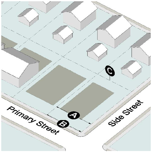 | |
| Lots | |
| Ⓐ Width: | 70 ft. min. |
| Ⓑ Frontage: | 35 ft. min. |
| Ⓒ Area: | 9,000 sf. min. |
4.10.4. - Building Placement
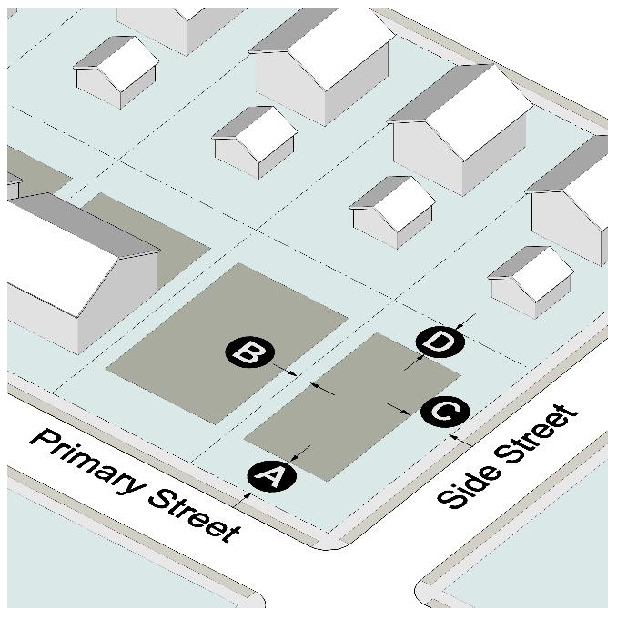 | |
| Principal Building Setbacks | |
| Ⓐ Front Yard: | 25 ft. min. |
| Ⓑ Side Yard (interior): | 7 ft. min. |
| Ⓒ Side Yard (street): | 20 ft. min. |
| Ⓓ Rear Yard: | 20 ft. min. |
| Accessory Structure Setbacks | |
| Accessory structures may be located in rear or side yards but must not be located within a minimum yard. Additional standards may apply to specific accessory uses in Sec. 8.8. | |
4.10.5. - Bulk and Mass
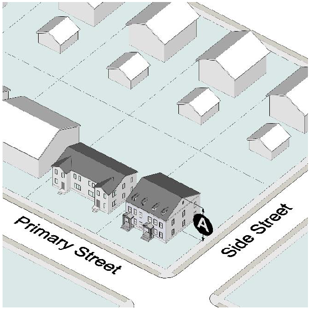 | |
| Building Height | |
| Ⓐ All Buildings: | 40 ft. max.[1] |
| Heated Floor Area | |
| Fewer Than Two-Story Dwelling: | 1,000 sf. min. on ground level |
| Two-Story Dwelling: | 1,100 sf. min. |
| More Than Two-Story Dwelling: | 1,100 sf. min. with 800 sf. min. on first story |
| Table note: | |
| [1] See Sec. 6.3 (Rural Milton Overlay) and Sec. 6.2.8.N (State Route 9 Overlay) for additional height limits. | |
4.10.6. - Overlay Compliance
Additional or alternative standards may apply within overlay districts.
A.
State Route 9 Overlay
See Sec. 6.2.
B.
Rural Milton Overlay
See Sec. 6.3.
4.11.1. - Scope and Intent
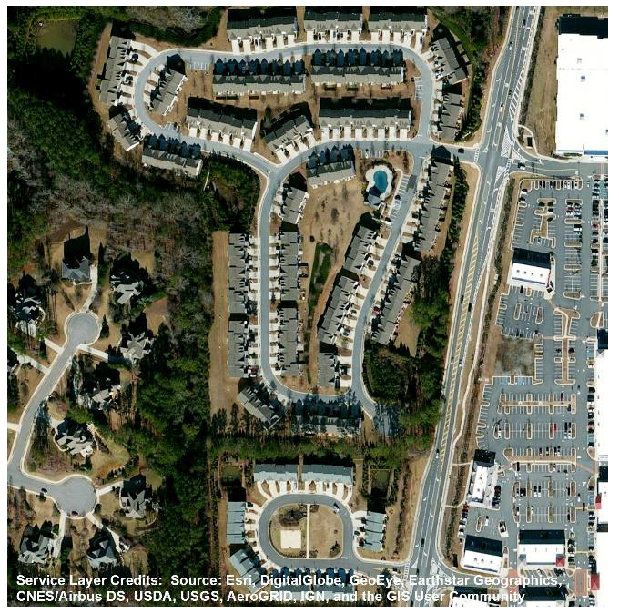
This section contains the TR district regulations. The TR district is intended to provide land devoted to high density uses consisting of townhouse, triplex, and quadruplex dwellings. Land zoned TR is further intended to provide a transition between medium density and higher density residential areas or between high density residential and nonresidential use. The district is intended to:
A.
Encourage the provision of usable open space and recreation areas as part of a living environment.
B.
Be located primarily in areas near or adjacent to single-family areas.
C.
Be located so as to provide a transition between single-family areas and nonresidential areas.
D.
Be located near retail shopping and major thoroughfares.
E.
Encourage homeownership.
4.11.2. - Uses
See Article 8.
4.11.3. - Dimensional Standards
| |
| Site | |
| Density: | 9 units per gross acre max. |
| Ⓐ Perimeter Front Yard Setback: | 20 ft. min. |
| Ⓑ Perimeter Side Yard Setback (interior): | 30 ft. min. |
| Ⓒ Perimeter Side Yard Setback (street): | 20 ft. min. |
| Ⓓ Perimeter Rear Yard Setback: | 35 ft. min. |
| Ⓔ Frontage: | 150 ft. min. |
| Ⓕ Land Area Per Unit: | 2,000 sf. min. |
| Lots | |
| Ⓖ Width: | 25 ft. min. |
| Ⓗ Area: | 2,000 sf. min. |
4.11.4. - Building Placement
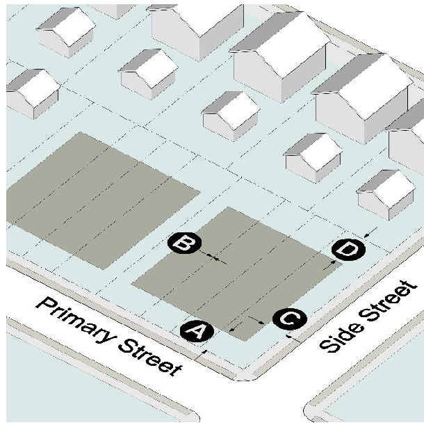 | |
| Principal Building Setbacks | |
| Ⓐ Front Yard: | 20 ft. min. |
| Ⓑ Side Yard (interior): | 7 ft. min. [1] [2] |
| Ⓒ Side Yard (street) | 15 ft. min. |
| Ⓓ Rear Yard: | 25 ft. min. |
| Accessory Structure Setbacks | |
| Accessory structures may be located within the side or rear yards only but not within minimum perimeter setbacks or minimum yards. Additional standards may apply to specific accessory uses in Sec. 8.8. | |
| Minimum Building Separation When More than One Building Per Lot | |
| At least 14 feet of building separation is required, unless more separation is specified by the City's building code | |
| Table notes: | |
| [1] Seven feet adjacent to interior lot line, except that up to a 7-foot encroachment and maintenance easement may be provided on the immediately adjacent parcel, in combination with or in lieu of a side yard. | |
| [2] Zero if units are attached, for example, townhouses on separate lots of record. | |
4.11.5. - Bulk and Mass
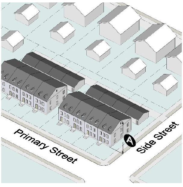 | |
| Building Height | |
| Ⓐ All Buildings: | 3 stories with the maximum height of 28 ft. from average finished grade to the bottom of the roof eave [1] |
| Heated Floor Area | |
| All Dwellings: | 1,800 sf. min. |
| Table note: | |
| [1] See Sec. 6.3 (Rural Milton Overlay) and Sec. 6.2.8.N (State Route 9 Overlay) for additional height limits. | |
4.11.6. - Development Standards
A.
Required Open Space or Recreational Facilities
1.
Developments with more than 50 units must provide at least 1,000 square feet of open space or recreational facilities per unit.
2.
Developments with 50 or fewer units must provide at least 750 square feet open space or recreational facilities per unit.
B.
Other Minimum Standards
1.
No more than eight dwelling units may form a single building.
2.
Setbacks and roof lines must be varied by at least two feet so that no more than three adjoining dwellings within a single building have the same front setback or roof line.
3.
A minimum of 80% of any common wall must be contiguous with each adjoining unit.
4.
Units adjacent to an exterior street must meet the following standards:
a.
Units must provide rear loaded vehicular access.
b.
The front unit facade must face the exterior street of the development.
5.
Each unit must provide two off-street parking spaces within the principal structure.
4.11.7. - TR District Subdivision
In the TR zoning district, dwellings proposed to be sold with the lot upon which the dwelling is located must comply with the subdivision regulations of this UDC.
4.11.8. - Overlay Compliance
Additional or alternative standards may apply within overlay districts.
A.
State Route 9 Overlay
See Sec. 6.2.
B.
Rural Milton Overlay
See Sec. 6.3.
4.12.1. - Scope and Intent
This section contains the A district regulations. The A district is intended to provide land areas for medium density apartment dwellings which will:
A.
Encourage attractive apartment development.
B.
Encourage the provision of recreation areas and facilities.
C.
Be located in areas of moderate to intense development near retail shopping, schools, and major thoroughfares.
D.
Be located so as to provide a transition between moderate density residential areas and high density residential areas or between moderate density residential areas and nonresidential areas.
4.12.2. - Uses
See Article 8.
4.12.3. - Dimensional Standards
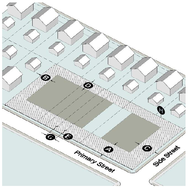 | |
| Site | |
| Density: | 14 units per gross acre max. |
| Site Lot Coverage: [1] | 40% max. |
| Ⓐ Perimeter Front Yard Setback: | 40 ft. min. |
| Ⓑ Perimeter Side Yard (interior): | 25 ft. min. |
| Ⓒ Perimeter Side Yard (street): | 40 ft. min. |
| Ⓓ Perimeter Rear Yard: | 25 ft. min. |
| Ⓔ Width (from front to rear lot line): | 200 ft. min. |
| Ⓕ Area Per Unit: | 2,000 sf. min. |
| Lots | |
| Ⓖ Frontage: | 35 ft. min. |
| Ⓗ Area: | 2,000 sf. min. |
| Table note: | |
| [1] Site lot coverage is the sum of all building footprints and parking on the site, divided into the total site land area. | |
4.12.4. - Building Placement
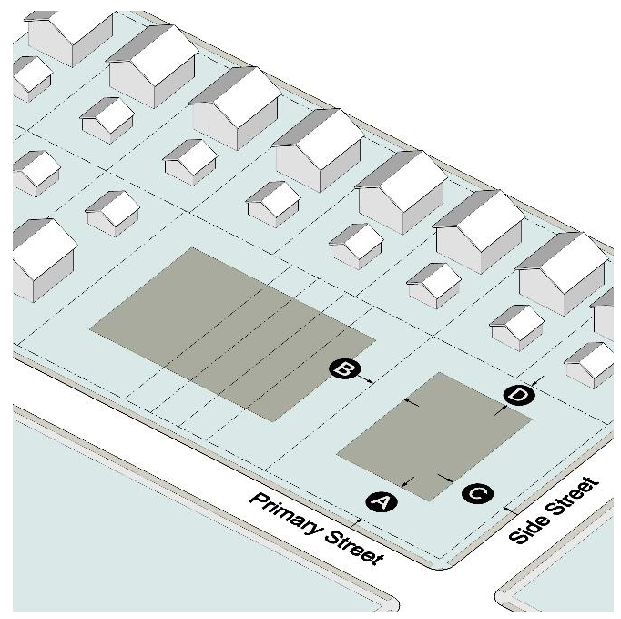 | |
| Principal Building Setbacks | |
| Ⓐ Front Yard: | 40 ft. min. |
| Ⓑ Side Yard (interior): | 25 ft. min. [1] |
| Ⓒ Side Yard (street): | 40 ft. min. |
| Ⓓ Rear Yard: | 25 ft. min. |
| Accessory Structure Setbacks | |
| Single-Family, Duplex Uses: | Accessory structures may be located in the rear and side yards only but must not be located within a minimum yard. Additional standards may apply to specific accessory uses in Sec. 8.8. |
| Multifamily Uses: | Accessory structures may be located in the rear yard only but must not be located in the minimum yard. Additional standards may apply to specific accessory uses in Sec. 8.8. |
| Interior Building Separation | |
| All building separations shall be as specified by the City's building code. | |
| Table note: | |
| [1] Zero if units are attached, for example, townhouses on separate lots of record. | |
4.12.5. - Bulk and Mass
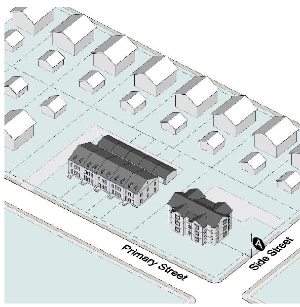 | |
| Building Height | |
| Ⓐ All Buildings: | 40 ft. max. [1, 2] |
| Heated Floor Area | |
| Single-Family Dwelling: | 1,100 sf. min. |
| Two-Family Dwelling: | 800 sf. min. |
| Efficiency or Studio: | 450 sf. min. |
| All other Multifamily Dwellings | 700 sf. min. |
| Table notes: | |
| [1] Greater building heights may be approved through the use permit procedures of Sec. 12.5.2. | |
| [2] See Sec. 6.3 (Rural Milton Overlay) and Sec. 6.2.8.N (State Route 9 Overlay) for additional height limits. | |
4.12.6. - Overlay Compliance
Additional or alternative standards may apply within overlay districts.
A.
State Route 9 Overlay
See Sec. 6.2.
B.
Rural Milton Overlay
See Sec. 6.3.
4.13.1. - Scope and Intent
The section contains the A-L district regulations. The A-L district is intended to provide land areas for high to very high density apartment dwellings which will:
A.
Encourage attractive apartment living opportunities.
B.
Encourage the provision of recreation areas and facilities.
C.
Be located in areas of intense development near retail shopping, schools and major thoroughfares.
D.
Be located so as to provide a transition between medium density residential areas and nonresidential areas.
4.13.2. - Uses
See Article 8, including Sec. 8.8.2.
4.13.3. - Dimensional Standards
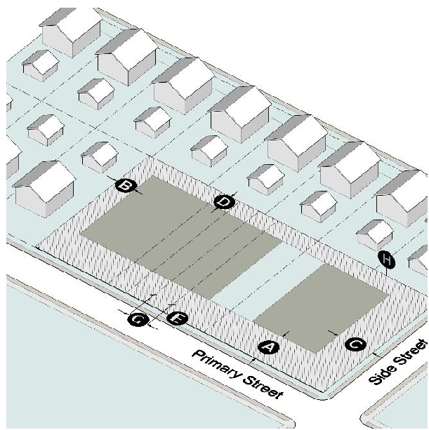 | |
| Site | |
| Site Lot Coverage: [1] | 70% max. |
| Outdoor Recreation: [2] | 10% min. |
| Ⓐ Perimeter Front Yard Setback: | 40 ft. min. |
| Ⓑ Perimeter Side Yard (interior): | 20 ft. min. |
| Ⓒ Perimeter Side Yard (street): | 40 ft. min. |
| Ⓓ Perimeter Rear Yard: | 20 ft. min. |
| Ⓔ Width (from front to rear lot line): | None. |
| Lots | |
| Ⓖ Frontage: | 35 ft. min. |
| Table note: | |
| [1] Site lot coverage is the sum of all building footprints and parking on the site, divided into the total site land area. | |
| [2] Using gross land area. | |
4.13.4. - Building Placement
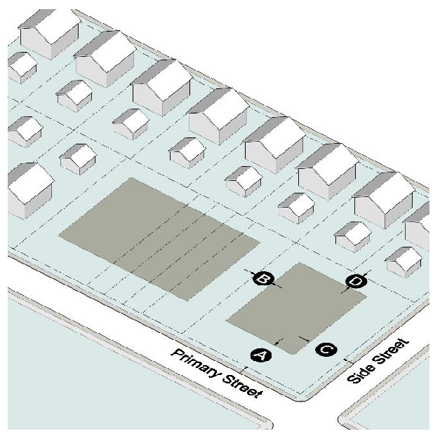 | |
| >Principal Building Setbacks | |
| Ⓐ Front Yard: | 40 ft. min. |
| Ⓑ Side Yard (interior): | 20 ft. min. [1] |
| Ⓒ Side Yard (street): | 40 ft. min. |
| Ⓓ Rear Yard: | 20 ft. min. |
| Accessory Structure Setbacks | |
| Accessory structures must not be located in the minimum front yard. Additional standards may apply to specific accessory uses in Sec. 8.8. | |
| Interior Building Separation | |
| All building separations shall be as specified by the City's building code. | |
| Table note: | |
| [1] Zero if units are attached, for example, townhouses on separate lots of record. | |
4.13.5. - Bulk and Mass
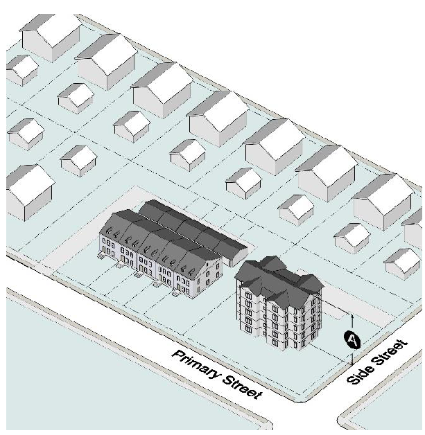 | |
| Building Height | |
| Ⓐ All Buildings: | 60 ft. max. [1, 2] |
| Heated Floor Area | |
| Three Bedrooms: | 700 sf. min. |
| Two Bedrooms: | 600 sf. min. |
| One Bedroom: | 500 sf. min. |
| Efficiency or Studio: | 400 sf. min. |
| Table notes: | |
| [1] Greater building heights may be approved through the use permit procedures of Sec. 12.5.2. | |
| [2] See Sec. 6.3 (Rural Milton Overlay) and Sec. 6.2.8.N (State Route 9 Overlay) for additional height limits. | |
4.13.6. - Overlay Compliance
Additional or alternative standards may apply within overlay districts.
A.
State Route 9 Overlay
See Sec. 6.2.
B.
Rural Milton Overlay
See Sec. 6.3.
4.14.1. - Scope and Intent
A.
This section contains the CUP District regulations for those properties that were zoned to the CUP district before December 20, 2021. After December 20, 2021, no additional property may be rezoned to the CUP district. The CUP district identifies land areas for a variety of housing types within a planned community setting.
B.
The CUP district is intended to:
1.
Encourage the development of land as planned communities.
2.
Encourage flexible and creative concepts in site planning.
3.
Preserve the natural amenities of the land by encouraging scenic and functional open areas.
4.
Provide for an efficient use of land.
5.
Provide a stable residential environment compatible with surrounding residential areas.
6.
Protect neighboring properties by requiring larger peripheral lots adjacent to larger lot developments.
4.14.2. - Uses
See Article 8, including Sec. 8.8.1.
4.14.3. - Development Plan
A.
The development plan is the zoning control document for features depicted graphically. The site plan requirement applicable to rezoning requests must be adhered to for CUP rezoning requests.
B.
Administrative guidelines for preparing site plans are available from the Director.
C.
A site plan will become the development plan if the request to rezone is approved without changes or additions.
D.
If the approval by the City Council differs in any way from what is depicted on the site plan submitted for the purpose of seeking rezoning, a revised plan must be certified by the Director before development related permits may be issued.
E.
A site plan or development plan must not substitute for plans which are required as a prerequisite for applying for development-related permits.
F.
The location of all use areas must be shown on the development plan, and the location on the ground must be as shown on the development plan.
G.
Properties that are not served by sanitary sewer must provide a site plan to determine the maximum number of lots on the subject site as follows.
H.
The number of lots in a CUP development must not exceed the number of lots that can be reasonably created within an AG-1 zoned development at the same location. The following items must be submitted to determine the lot yield for the subject property:
1.
The location of all bodies of water and the appropriate buffers.
2.
A level 3 soil analysis.
3.
A tree survey indicating specimen and heritage trees.
4.
The configuration of lots and associated minimum building setbacks.
5.
Approximate locations of house footprints on each lot.
4.14.4. - Development Standards
A.
Height Regulations
The height of non-single family residential structures is as specified in conditions.
B.
Minimum Land Area Per Unit
The minimum land area per unit is as specified in conditions.
C.
Minimum Lot Area Per Unit
The minimum lot area per unit is as specified in conditions.
D.
Development Size Standards
The minimum CUP size is 4 contiguous acres.
E.
Density
Maximum density is as follows:
1.
Single-family dwelling: 5.0 units per gross acre.
F.
Minimum Lot Width
There is no minimum lot width, unless specified in conditions.
G.
Minimum Frontage for the Entire CUP Development
The minimum CUP development frontage is 150 feet.
H.
Minimum Lot Frontage
The minimum lot frontage is 20 feet adjoining a street.
I.
Minimum Heated Floor Area
The minimum heated floor area per unit is as specified in conditions.
J.
Minimum Perimeter Setbacks
The minimum perimeter setback for the entire development is as specified in conditions.
K.
Minimum Interior Setbacks
1.
The minimum front yard is as specified in conditions.
2.
The minimum side yard is as specified in conditions.
3.
The minimum rear yard is as specified in conditions.
L.
Accessory Structure Requirements
Accessory structures may be located within the side or rear yards subject to perimeter and minimum yard setbacks.
M.
Minimum Building Separation (more than one dwelling per lot)
All building separations must be as specified by the City's building code.
N.
Other Minimum Standards
Agreements, covenants, declarations, and other contracts which govern the use, maintenance, and protection of a CUP development among its owners' areas must be part of the official zoning file, and changes thereto have no force and effect until a copy has been provided to the Director.
4.14.5. - Entrances
Entrances from a public right-of-way for subdivisions with more than three lots must be rural, simple, and rustic in design, as determined by the City Architect, and must comply with the following:
A.
Signage
Signage must be one of the following designs:
1.
Shingle style.
2.
Sign mounted in or on pillar, provided the pillar must not exceed 8 feet high.
B.
Walls
1.
Knee walls may be utilized where required by existing topography and must not exceed 20 linear feet on either side of the subdivision's road entrance.
2.
Knee walls must be constructed of natural materials such as boulders, stacked stone, or wood formed brick or materials designed to give the appearance of such natural materials, as shown in Figures 4.14.5.A and 4.14.5.B. Stucco is prohibited.
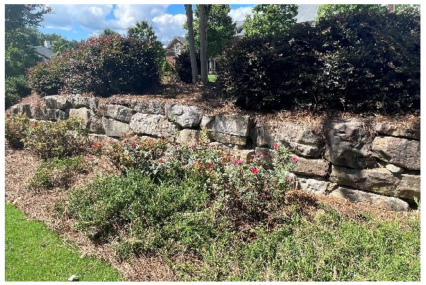
Figure 4.14.5.A
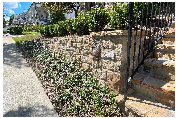
Figure 4.14.5.B
C.
Other Structures
Gate or guard structures must be set back at least 60 feet from exterior street rights-of-way.
D.
Water Features
Water features are not allowed.
4.14.6. - Rural Viewshed
A.
Applicability
This subsection only applies to subdivisions with more than three lots. The requirements of this subsection, except for Sec. 4.14.6.B.4, do not apply to a single lot of record or to subdivisions with three or fewer lots where no individual lot abuts an exterior street.
B.
Rural Viewshed Standards
1.
Applicable subdivisions must provide a 40-foot primary rural viewshed setback from all proposed Milton Trail or sidewalk easements or proposed rights-of-way, whichever is more restrictive, along the exterior streets for buildings, accessory structures, and swimming pools for lots adjacent to exterior streets:
a.
No disturbance within the 40-foot primary rural viewshed setback is allowed until a design review process is completed and the design of the rural viewshed is approved by the design committee.
b.
Driveways accessing exterior streets are prohibited within the 40-foot primary rural viewshed setback, except where they cross the rural viewshed in a perpendicular manner.
c.
Individual septic systems may be installed in the primary rural viewshed setback with an approved primary variance if the primary and secondary septic fields fail and the property may be condemned by the Fulton County Health Department without such variance. The property owner must provide proof of such potential condemnation prior to the application for a primary variance.
2.
Applicable subdivisions must also provide a 20-foot secondary rural viewshed setback from the primary rural viewshed setback for buildings, accessory structures, and swimming pools for lots adjacent to exterior streets.
a.
Individual septic systems may be installed in the secondary rural viewshed setback with an approved primary variance.
b.
Driveways accessing exterior streets are prohibited within the 20-foot secondary rural viewshed setback, except where they cross the rural viewshed in a perpendicular manner.
c.
No disturbance within the 20-foot secondary rural viewshed setback is allowed until a design review process is completed and the design of the rural viewshed is approved by the design committee.
3.
The intent of the rural viewshed is to preserve the bucolic views from the roads throughout the Rural Milton Overlay. The views may contain natural vegetation as well as equestrian related structures and uses. It is the intent to utilize the existing vegetation when possible as well as provide additional native plantings to enhance the existing viewshed when needed.
a.
When performing a design review of the primary rural viewshed and secondary rural viewshed setbacks, the design committee must address the following:
i.
Evaluation of current state of site including vegetation, both the primary and secondary rural viewshed setbacks.
ii.
Determination of whether existing vegetation should be removed or vegetation should be planted to enhance the rural viewshed.
iii.
Consideration of whether screening of the structures is necessary.
iv.
Consideration of the existence of open uses defined in Sec. 8.7 (Open Uses) in the area.
4.
For structures located on lots subject to a rural viewshed, an architectural review process is required. Such process will include a review of building elevations and landscape plans by the City Architect. These structures must be designed with 360-degree architecture and must meet the intent of Sec. 6.3.10 (Characteristics of Rural Milton Overlay).
5.
After the City issues the necessary permits to disturb the property, but before the required pre-construction meeting, the developer must install a 4 feet high orange tree save fence at least at the combined primary rural viewshed and secondary rural viewshed setback measured from the proposed Milton Trail or sidewalk easement or the proposed right-of-way. The fence must be installed so as to protect heritage trees, protected trees, and specimen trees as defined in Sec. 11.1 Tree Canopy Conservation or any other significant vegetation as determined by the City Arborist. The appropriate location of such fencing must be approved by the City Arborist. In addition, a sign must be posted on the fence every 25 feet indicating "rural viewshed." The tree save fence must be removed when the issuance of a certificate of occupancy for each lot abutting the viewshed is issued.
6.
Notwithstanding anything to the contrary in this subsection, agricultural operations (see Sec. 8.7.1.B) may occur in the primary rural viewshed and secondary rural viewshed setbacks.
7.
Before transfer of any legal interest in a CUP zoned parcel that is subject to a rural viewshed, every legal or beneficial owner of such a parcel must ensure that there is recorded in the chain of title for the parcel an affidavit stating the following:
"At the time of the execution of this Affidavit, the property with respect to which this Affidavit is filed is subject to certain restrictions contained in the Unified Development Code for the City of Milton, Georgia. Such restrictions may include restrictions on development and disturbance of property located in the rural viewshed, which includes portions of property adjacent to streets not located within a platted subdivision."
In addition, a copy of the affidavit must be provided to any transferee of a legal interest in the parcel no later than the final closing of the transfer.
C.
Architectural Review of Structures
The following requirements are for structures located on a single lot of record or a subdivision with fewer than four lots that abut an exterior street:
1.
An architectural review process is required and must include a review of building elevations and landscape plans by the City Architect.
2.
These structures must be designed with street elevation architecture and must meet the intent of Sec. 6.3.10 (Characteristics of Rural Milton Overlay).
D.
Violations and Penalties
For any disturbance of the rural viewshed before the appropriate approvals are issued, the property will be barred from being developed for three years following issuance of the notice of violation and must restore the land to its original landscape or if applicable with appropriate tree recompense as determined by the City Arborist.
4.14.7. - Fencing
A.
Height and Style
Fences must meet the standards of Sec. 2.3.2.E.
B.
Barbed Wire
Barbed wire is prohibited on any lots, except when part of an agriculture use defined in Sec. 8.7.1 (Agriculture).
C.
Setbacks
Fences and walls must be set back at least 3 feet from a public right-of-way.
4.15.1. - Scope and Intent
A.
This section contains the NUP district regulations for those properties that were zoned to the NUP district before December 17, 2013. After October 20, 2014, no additional property may be rezoned to the NUP district. The NUP district is intended to provide land areas devoted to low to medium density single-family residential uses of five or fewer units per acre consistent with the density ranges suggested on the Comprehensive Plan land use map. The NUP district is intended to encourage all of the following:
1.
The development of medium sized tracts of land as planned neighborhoods or the development of vacant parcels of land with transitional densities in built-up areas.
2.
The preservation of trees and vegetation.
3.
Innovative site planning.
B.
Land proposed for a NUP shall comply with the following standards:
1.
Provide a density that is consistent with the plan densities and surrounding properties.
2.
Protect neighboring properties by requiring peripheral setbacks and development standards compatible with adjacent developments as required by the district standards and the conditions of zoning.
4.15.2. - Uses
See Article 8.
4.15.3. - Development Plan
A.
The development plan is the zoning control document for features depicted graphically. The site plan requirement applicable to rezoning requests must be adhered to for NUP rezoning requests.
B.
Administrative guidelines for preparing site plans are available from the Director.
C.
A site plan will become the development plan if the request to rezone is approved without changes or additions.
D.
If the approval by the City Council differs in any way from what is depicted on the site plan submitted for the purpose of seeking rezoning, a revised plan must be certified by the Director before development related permits may be issued.
E.
A site plan or development must not substitute for plans which are required as a prerequisite for applying for development related permits.
F.
The location of all use areas must be shown on the development plan, and location on the ground must be as shown on the development plan.
4.15.4. - Development Standards
A.
Development Size Standards
NUP size must be as follows:
1.
Minimum 4 contiguous acres.
2.
Maximum 12 contiguous acres.
B.
Density
Maximum density is 5.0 units per gross acre.
C.
Minimum Lot Width
There is none unless specified in conditions.
D.
Minimum Development Frontage
Minimum development frontage is 35 feet.
E.
Minimum Heated Floor Area
Minimum heated floor area per unit is 1,000 square feet detached.
F.
Minimum Perimeter Setback for the Entire NUP Development
When adjacent to single-family zoning/use or agricultural district, a 40-foot setback must be provided around the periphery of the development including access drives serving more than one lot, principal and accessory structures and swimming pools. Other yard improvements and access/utility crossings are permitted.
G.
Minimum Interior Setbacks
1.
Minimum front yard is as specified in conditions.
2.
Minimum side yard is as specified in conditions.
3.
Minimum rear yard is as specified in conditions.
H.
Minimum Interior Building Separations
To place a building along an interior side lot line at between zero and 7 feet requires an encroachment and maintenance easement allowing a minimum of 7 feet of access to such buildings. The easement must be provided on the immediately adjacent parcel. At least 14 feet of building separation is required, unless more separation is specified by the City's building code.
I.
Accessory Structure Requirements
Accessory structures may be located in rear or side yards, but must not be located within a minimum rear yard except that detached garages may be located along a rear lot line at between zero and 7 feet with an encroachment and maintenance easement allowing a minimum of 7 feet of access to the garage.

