Ravenswood City Zoning Code
16.12.020 Land
Use Districts
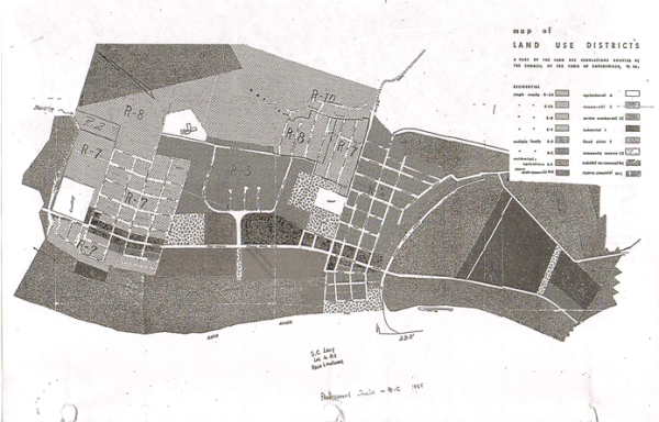
- The several districts hereby established and into which the Town of Ravenswood and area regulated by this Ordinance are designated, are as follows:
Agricultural District (A) Residential-Agricultural (RA) Single-Family Residence Districts (R-20, R-10, R-8, and R-7) Multiple-Family Residence Districts (R-3 and R2) Restricted Residential-Commercial (RR-C) Commercial District (C) Service Commercial District (SC) Reserve Commercial (RC) Light Industrial District (I) Flood Plain District (F) Community Reserve District (CR) - The designations, locations, and boundaries of the aforesaid districts are set forth in this section which consists of the Land Use Regulations Map or Maps of the Town of Ravenswood and its environs. Said Map or Maps and all notations, references, data and other information shown thereon shall be and are hereby adopted and made a part of these Land Use Regulations.
- Where uncertainty exists as to the boundaries of any of the aforesaid districts as shown on said Maps, the Planning Commission, upon written application or upon its own motion, shall determine the locations of such boundaries.
- All territory hereafter annexed to the Town of Ravenswood shall be classified as a part of such Land Use District or Districts of the Town of Ravenswood specified by the Town Council after consideration of the recommendations of the Planning Commission at the time of annexation thereof. Said annexed territory and area shall retain such Land Use classification unless said territory and area shall be otherwise reclassified in the manner prescribed by law.
- Except as hereinafter otherwise provided:
- No building or part thereof or other structure shall be erected, altered, added to or enlarged, nor shall any land, building, structure or premises be used, designated or intended to be used for any purpose or in any manner other than is included among the uses hereinafter listed as permitted in the district in which such building, land, or premises is located.
- No building or part thereof or structure shall be erected, reconstructed or structurally altered to exceed in height the limit hereinafter designated for the districts in which such building is located.
- No building or part thereof or structure shall be erected, nor shall any existing building be altered, enlarged or rebuilt or moved into any district, nor shall any open space be encroached upon or reduced in any manner, except in conformity to the yard, building site area and building location regulations hereinafter designated for the district in which such building or open space is located.
- No yard or other open space provided about any building for the purpose of complying with the provisions of this Ordinance shall be considered as providing a yard or open space for any other building, and no yard or other open space on one building site, shall be considered as providing a yard or open space for a building on any other building site.
- This section consists of the Land Use District Map or Maps of the Town of Ravenswood, West Virginia, and its environs made a part of these Land Use Regulations. Said Map or Maps, properly attested, shall be and remain on file in the office of the Planning Commission.
- This section consists of RMC 16.12.210 Chart A.