
Grandview City Zoning Code
31-23
SITE PLAN REVIEW PROVISIONS
(A)
Intent.
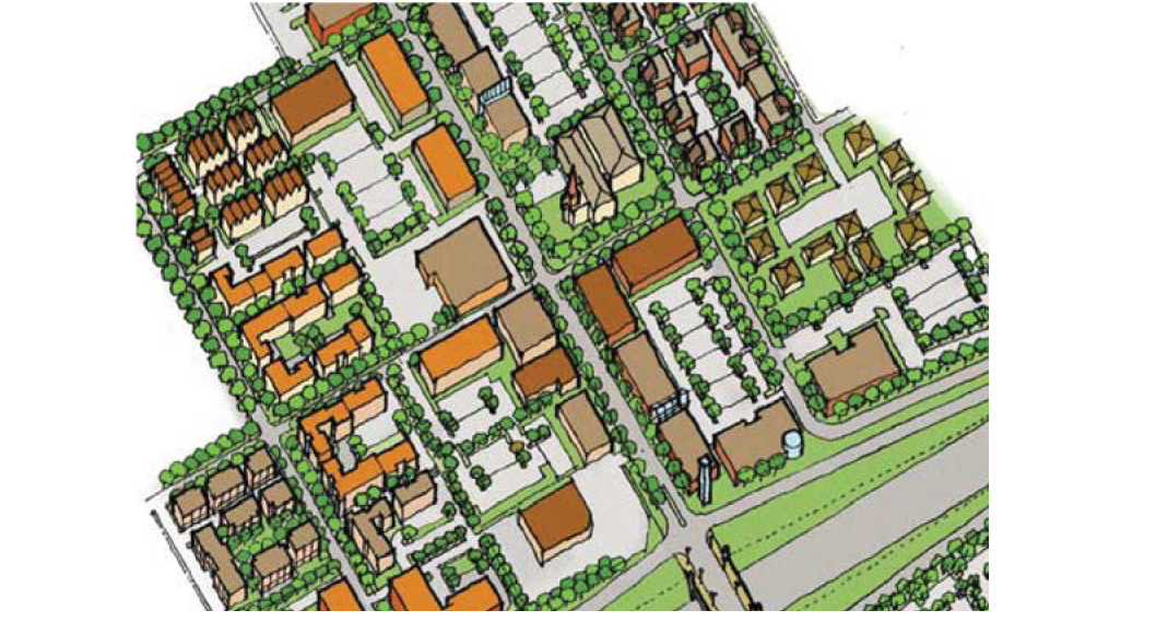
The site plan review provisions of this Section are intended to promote the functional and aesthetic development of property. Regulations of this Section are intended to ensure that new structures, utilities, streets, parking, circulation systems, yards and open spaces are developed in conformance with the standards of this Ordinance and the Comprehensive Plan.
(B)
Application, Scope, and Site Work Completion Timing.
No building permit shall be issued, and no construction, grading or other land development activity listed below may be commenced on property unless a Site Plan has been submitted and approved for such activity as set forth in this Section or with approval from the Director of Community Development, except pursuant to Section 31-23 of this Ordinance.
An applicant for site-plan review and approval shall be the property owner or developer for the subject site, which may include the holder of an option or contact purchase, or other person having an enforceable proprietary interest.
Development activities subject to the requirements of this Section may hereafter be carried out only in substantial conformance with the approved Site Plan and any conditions or restrictions attached thereto. Any substantial deviation from the approved Site Plan, unless approved in advance and in writing by the Director of Community Development, shall be deemed a violation of this Ordinance. Further, no certificate of occupancy shall be issued if said development activities do not conform to the approved site plan. However, in such cases where certain development requirements cannot be met immediately due to weather conditions, the Director of Community Development may issue a temporary certificate of occupancy provided that adequate surety for such requirements has been made and a completion date for which such development requirement will be provided. Said completion shall not exceed a period of six months from date of issuance of the temporary certificate of occupancy.
(C)
Development Activities Subject to Site Plan Review.
(1)
Construction or expansion of any building structure, existing site design, or free-standing sign.
(2)
Any change, alteration, or modification in a structure or use that would require the provision of additional off-street parking or loading spaces, additional lot area, or other substantial change in zoning requirements applicable to such structure or use.
(3)
The construction, creation or expansion of any parking lot or any change from the approved striping plan of any parking lot.
(D)
Administrative Waiver of Site-Plan Review — When Permitted.
The Director of Community Development may waive the requirements for Site-Plan review for any development activity within the scope of this Section when there is reasonable belief that such a waiver will not adversely affect the purposes and intent of this Ordinance.
(E)
Contents of Site-Plan — Graphic.
The Site Plan shall be drawn and signed by an architect, engineer, or land surveyor registered in the State of Missouri, and shall contain the seal of the same. The Site Plan shall include one or more appropriately scaled maps or drawings (scale no smaller than fifty feet (50') to the inch) of the property clearly and accurately indicating the following:
(1)
Commercial, Office, Industrial or Multi-Family Residential Developments:
(a)
Complete property dimensions, area of lot in square feet, and existing easements;
(b)
The location, grade, and dimensions of all present and/or proposed streets, sidewalks, curbs or other paved surfaces and engineering cross-sections of proposed new curbs and pavement;
(c)
Complete parking, traffic, and pedestrian circulation plans, if applicable, showing location and dimensions of driveways and between driveways, parking stalls, drive aisles, dividers, sidewalks and crosswalks, bicycle parking racks, planters or similar permanent improvements; perimeter screening treatment, including landscaping;
(d)
Landscaping plans showing all open areas, including size, location, and type of all plantings, and all sodded and seeded areas in accordance with all landscaping requirements of this Ordinance;
(e)
Location and full dimensions of all buildings or major structures, both proposed and existing, showing exterior dimensions, exterior materials, and area of floors, location, number and type of dwelling units, height of building(s), distance to all property lines, distance between structures, and dimensions and locations of all loading areas;
(f)
Location of all trash receptacles and details of required enclosures;
(g)
Type of monuments at each corner of site;
(h)
Existing and proposed contours of the property taken at regular contour intervals (as per USGS datum) not to exceed five feet (5'), or two feet (2') if the Director of Community Development determines that greater contour detail is necessary to satisfactorily make the determinations required by this Ordinance;
(i)
The general nature, location, and size of all significant existing natural land features, including but not limited to sidewalks or paths, tree or bush masses, all individual trees over four inches (4") in caliper, grassed areas, surface rock and/or soil features, and all springs, streams, or other permanent or temporary bodies of water; (the developer is encouraged to retain as many existing trees as practicable);
(j)
A locational map or other drawing at appropriate scale showing the general location and relation of the property to surrounding areas, including, where relevant, the zoning and land-use pattern of adjacent properties, the existing street system and driveways in the area and location of nearby public facilities to include the location of all fire hydrants within 1,000 feet;
(k)
For sites of one acre or more, a proposed stormwater retention/detention system complying with the Kansas City American Public Works Association standards. Design computations shall be submitted separately;
(l)
Existing and proposed on-site utilities that will serve the site. Sanitary sewer shall show two manholes and location, and elevation of stub, if any, that serves the property;
(m)
Performance Standards listed in each zoning district and/or design standards set forth in Section 31-27(J) for the M150 & I-49 Corridors and the accompanying plan in the appendix of this Ordinance.
(n)
Additional graphic information as may be required by the Director of Community Development or other city agencies to make determinations required by this Ordinance.
(2)
Single-Family and Two-Family Residential Developments:
(a)
Complete lot dimensions and legal description of proposed building sites;
(b)
Location and full dimension of all buildings, showing exterior dimensions, number and area of floors, elevation of lowest floor to be served by sewer, and distances from property lines;
(c)
Location of all easements;
(d)
Location of utilities to serve the lot, to include the location of all existing fire hydrants within 600 feet. Sanitary sewer shall show two manholes and location and elevation of a stub, if any, that serves the property;
(e)
If lot is within a designated FEMA floodplain, all information as required by Section 11A of the Code of Laws of the City of Grandview is to be provided;
(f)
The elevation of the centerline of the proposed driveway at the top of the street curb or alleyway, right-of-way line, and garage floor. If no curb exists, then the elevation of the edge of pavement shall be shown (Note: refer to City driveway standards);
(g)
Additional graphic information as may be required by the Director of Community Development or other city agencies to make determinations required by this Ordinance.
(F)
Contents of Site-Plan — Written.
All Site Plans shall include a report or narrative containing the following:
(1)
Legal description and address of the property;
(2)
Name, address, and phone number(s) of the property owner(s);
(3)
Name, address and phone number(s) of the developer(s) or contractor(s), if different than the owner(s);
(4)
Proposed use(s) for all non-residential buildings or structures;
(5)
Data clearly identifying the following: total number and type(s) of dwelling units on the property; number and type of all structures or buildings, whether residential or non-residential; total area of the property; total floor area of each building; and total landscaped area;
(6)
Proposed landscaping schedule indicating plant types, sizes, number, and timing for installation;
(7)
Proposed construction schedule of all structures and physical improvements indicating the timing and sequence of each major structure and improvement;
(8)
Present zoning classification(s) of the property;
(9)
Present and proposed type, size, and number or parking spaces on the property;
(10)
Submittal of engineering drainage design computations for lots of one (1) acre or more from a professional engineer;
(11)
Exterior lighting shall be provided for sidewalks and areas of pedestrian circulation and for off-street parking areas providing space for five (5) or more vehicles for which spaces are normally used during the hours of darkness after 6:00 p.m. The lighting fixtures shall provide at least an average of one-fourth (0.25) foot candle over the entire parking lot area, measured on the ground surface and shall be shaded so that no direct light is cast upon any property located in a residential district and so that no glare is visible to any traffic upon any public street;
(12)
For five (5) or more acre development, submittal of proof of application for stormwater discharge permit or proof that a permit is not required;
(13)
A traffic impact study may be required by the Directors of Community Development or Public Works if the proposed development is likely to generate a substantial increase in vehicle trips per day.
(G)
Site Development Standards.
(1)
All commercial and industrially zoned properties shall be in conformance with the Performance Standards listed in each district's section of this Ordinance.
(2)
The Site Plan must show that a reasonable effort has been made to conserve and protect those natural characteristics that are of some lasting benefit to the site, its environs and the community at large.
(3)
Slopes that exceed ten percent (10%) shall be protected by appropriate measures against erosion, run-off, unstable soil, trees and rocks, as regulated by the Kansas City American Public Works Association specifications.
(4)
All uses as required and all off-street parking and loading areas, all rubbish and garbage areas, all outside storage areas and all tow lots and salvage/junk yards shall be screened in accordance with this Ordinance.
(5)
The placement of buildings, structures, fences, lighting and fixtures on each site shall not interfere with traffic and pedestrian circulation, safety, appropriate use and enjoyment of adjacent properties.
(6)
On any corner lot, except in the C-3, Zoning District, a sight triangle shall be provided in which nothing shall be erected, placed, planted, or allowed to grow in such a manner as to materially impede vision above a height of three feet (3') from the grades at the back of the curb of the intersecting streets and in accordance with Section 31-5(P) of this Ordinance. In the case of streets with no curb, the measurement shall be based off the grade of the street pavement edge on all corners of the intersection. The sight triangle will vary in dimensions based on the classification of the adjacent roadways.
(7)
Adequate illumination of a 0.25 foot candle, measured on the ground surface, shall be provided to parking lots, sidewalks and other areas for vehicular and pedestrian circulation, but shall be shaded so that no direct light is cast upon any property located in a residential district and so that no glare is visible to any traffic on any public street.
(8)
All parking spaces shall be clearly marked by striping or other means acceptable to the Director of Community Development and in accordance with Section 31-23(I) Parking Lot Design Standards. Parking space markings shall be maintained in conformance with the approved site plan. Signs and pavement markings shall be used as appropriate to control traffic access and egress.
(9)
All areas other than City streets to include commercial and industrial drives designed for vehicular use shall be paved with a minimum of either a six inch (6") rolled stone base over a two inch (2") asphaltic concrete mat, a six inch (6") Portland cement concrete pavement, or other equivalent pavement approved by the Director of Community Development, except that residential driveways serving six (6) or less vehicles may be a minimum of either a four inch (4") rolled stone base with a two inch (2") asphaltic concrete overlay or four inches (4") of Portland cement concrete. If an alternative to this requirement is proposed, such as other paving materials and depths or permeable paving, the Director of Community Development shall review the request and make a determination to approve or deny the requested deviation. The paving surface must be so designed and maintained as to allow prompt and effective drainage of natural precipitation. No water drainage across sidewalks shall be allowed.
(10)
Developments are encouraged to utilize green infrastructure whenever possible to slow and filter stormwater run-off. For all developments, those proposing green infrastructure may be awarded density bonuses by the Director of Community Development relating to minimum lot area, coverage, setback, and parking requirements. See Section 31-23(H)(3).
(11)
All utility service transmission systems, including but not limited to water, sewer, natural gas, electrical and telephone lines shall be placed underground. All aboveground utility boxes shall be screened from view of any public right-of-way or residential use.
(12)
All public improvements must conform to the Kansas City Metro American Public Works Association specifications and requirements. The City Engineer should be contacted for such information.
(13)
If in a designated erosion hazard area, see Section 31-23(L) of this Ordinance.
(14)
In-ground sprinkler systems shall be installed, in and around all landscaping required to be installed by Section 31-25 of this Ordinance, in office, commercial, and industrial districts and residential developments with structures containing three (3) or more dwelling units per building.
(15)
Pedestrian access shall be an integral part of the overall design of the development. The pedestrian access shall provide not only safe and convenient access to and from off-street parking areas, but shall also connect with abutting properties and developments so as to accommodate an alternative means of transportation such as walking or biking to and from work and surrounding activities. Access to site or park amenities shall also be provided.
(16)
In all commercial and industrial zones, except C-3, detached sidewalks at least 5 feet in width shall be provided along all sides of a lot that abut a dedicated public or private street where sidewalks are required by the Kansas City American Public Works Association specifications and/or Grandview's Subdivision Regulation. A continuous internal pedestrian sidewalk and/or designated walkway shall be provided from the perimeter public sidewalk to the principal building entrance(s).
Sidewalks should be provided along the full length of any façade featuring a customer entrance and along any façade abutting a public parking area. Such sidewalks should be located at least ten feet away from the building façade to provide planting areas for landscaping along the foundation of the building.
(H)
Low Impact Development Standards.
Greenfield and redevelopment sites of one (1) acre or greater in size are required to address Best Management Practices (BMPs), accounting for the increase in post-development stormwater run-off and filtration as compared to pre-development conditions.
(1)
Alternative Designs for BMP Compliance.
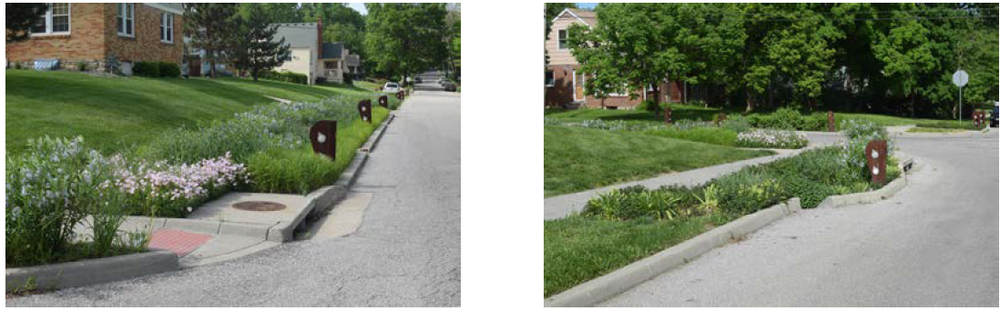
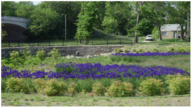
The City of Grandview looks to enhance site design and improve stormwater collection and filtration through methods other than barren above ground extended wet or dry detention basins. Functionally, detention basins serve the purpose of collecting, filtering, and releasing stormwater into our systems. However, these basins often consume large areas of land, are situated in prominent areas on a site near public right-of-way, and typically appear to be barren. The following BMP solutions are examples of alternative designs. The Mid-America Regional Council's (MARC) BMP Manual for Stormwater Quality shall be referenced to accommodate this Ordinance.
(2)
Examples of sustainable development infrastructure include, but are not limited to:
(a)
Bioswales.
(b)
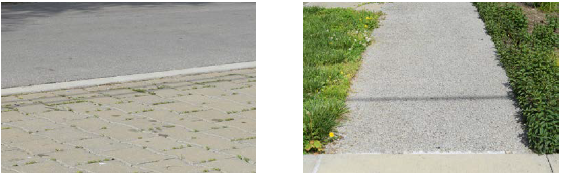
Pervious materials such as permeable paving or pavers.
(i)
Used for sidewalks, drive aisles or entire off-street parking lots.
(c)
Preserving overland flow paths as part of the stormwater system.
(d)
Landscaping on-site detention areas with vegetation that will help absorb stormwater while providing visually appealing scenery.
(3)
Density Bonuses.
The Director of Community Development may authorize incentives in the form of density bonuses to those developments proposing alternative forms of green infrastructure that accomplish or go beyond the required BMPs. MARC's Manual of Best Management Practices for Stormwater Quality Section 4 shall be referenced for achieving the standards of this section. Density bonuses relate to minimum lot area, maximum lot coverage, off-street parking minimums or maximums, and setback requirements.
When a development's BMPs are calculated, a particular number of "points" are required to be met. When these "points" are achieved through alternative forms of green infrastructure or there are more BMPs provided on-site than the minimum requirement, and are not exclusively above ground barren extended wet or dry detention basins, negotiations for the following may occur:
(a)
Maximum Lot Coverage
(b)
Minimum Lot Area
(c)
Off-street Parking Minimums or Maximums
(d)
Minimum Setbacks
The following are percentages of a developments BMPs that will be calculated to determine which incentives are available for negotiations:
60% of required BMPs met through alternative forms of green infrastructure
i.
Density Bonuses
1.
Maximum Lot Coverage
100% of required BMPs met through alternative forms of green infrastructure
i.
Density Bonuses
1.
Maximum Lot Coverage
2.
Minimum Lot Area
0 — 10% of additional BMPs beyond required minimum met through alternative forms of green infrastructure
i.
Density Bonuses
1.
Maximum Lot Coverage
2.
Minimum Lot Area
3.
Minimum Setbacks
11 — 20% of additional BMPs beyond required minimum met through alternative forms of green infrastructure
i.
Density Bonuses
1.
Maximum Lot Coverage
2.
Minimum Lot Area
3.
Minimum Setbacks
4.
Off-Street Parking Minimums
21 — 30% of additional BMPs beyond required minimum met through alternative forms of green infrastructure
i.
Density Bonuses
1.
Maximum Lot Coverage
2.
Minimum Lot Area
3.
Minimum Setbacks
4.
Off-Street Parking Minimums
5.
Off-Street Parking Maximums
(4)
Redevelopment Sites.
In most cases, sites that are being redeveloped from one use to another with less than or no additional impervious area, while not typically required to provide new stormwater facilities, shall be eligible for density bonuses listed in subsection three (3) of this section if alternative forms of green infrastructure are proposed.
(5)
Maintenance of Green Infrastructure Facilities.
In order to ensure that private green infrastructure facilities are maintained, a maintenance agreement shall be signed by the property owner and recorded. This agreement, to be submitted with a site plan, will require an inspection every three (3) years to ensure the systems remain functional. The owner of the property at the time of inspection shall be responsible for all associated costs including maintenance.
(I)
Parking Lot Design Standards.
( ) = Stall depth for overlap at Center Island.
See section 31-23(J) for parking space dimensions for persons with disabilities.
See section 31-25 Landscaping and Screening Requirements for further parking lot design details.
(J)
Parking Space Standards for Persons with Disabilities.
Parking facilities shall be provided for persons with disabilities according to the following regulations for the exclusive use of vehicles that display a distinguishing license plate or placard issued pursuant to RSMo 301.071 or 301.142, and shall be established in accordance with the following standards.
(1)
All free off-street parking facilities shall provide parking for persons with disabilities, except those parking facilities maintained in conjunction with single-family or two-family residential units and owner-occupied town house developments where parking is assigned. For industrial establishments, areas set aside exclusively for visitor parking and clearly signed accordingly will be exempted if the number of visitor spaces is ten (10) or less.
(2)
The number of parking spaces required by this section shall be determined in accordance with the following table:
(3)
The parking space shall be indicated by the posting of a sign upon which shall be the international symbol of accessibility in white on a blue background and which may include appropriate wording to further identify the space. Van accessible spaces shall have an additional sign stating "van accessible" below accessibility symbol.
(4)
Such space shall be located as close as possible to the nearest accessible entrance, and, if possible, located so that no traffic or parking lane (or other similar obstacle) must be crossed to get from the space to the entrance.
(5)
Such standard accessible spaces shall be a minimum of 8' x 19' in area with an unobstructed 5-foot (5') wide access aisle adjacent to the space. Two such adjoining parking spaces may share an access aisle located between them. Van accessible spaces shall be a minimum of 8' x 19' with an unobstructed 8' wide access aisle adjacent to the space. One (1) of every four (4) accessible spaces, but not less than one (1) space, shall be van accessible.
(K)
Required Procedures for Site-Plan Review
(1)
Applicants for Site-Plan Review shall meet with the Site-Plan Review Team for a Pre-Application Meeting. Typically, this meeting will consist of the Director of Community Development, City Engineer, Building Official, Planner, and representatives from the Fire Department and Water District, prior to submission of a Site Plan. The purpose of this meeting is to acquaint applicants with site development standards and procedures. This meeting shall also serve to allow the applicant to present the scope and nature of the proposed project to the Site-Plan Review Team.
(2)
Following the Pre-Application Meeting, the applicant may submit a completed Development Services Application, Review Fee, and Civil Site Plan Package for review. Contact the City Planner for the necessary number of sets needed for review.
(3)
Within fifteen (15) working days of receiving a Civil Site Plan Package, the applicant shall be notified of any approval, conditional approval or disapproval. In cases of conditional approval or disapproval, written notification shall be given for the reasons of such action.
(4)
The Site Plan Review Team shall review the Site Plan for consistency with city planning policies and objectives and compliance with all applicable regulations and standards.
(5)
Two (2) copies of the approved Site Plan shall be returned to the applicant. One (1) copy of the approved Site Plan shall remain in the records of the Building Official, and one (1) copy shall remain in the records of the Planner.
(L)
Erosion-Hazard Areas.
In an area designated as an erosion-hazard area, detailed engineering plans for the erection of structures, for the removal or fill or storage of topsoil, sand, gravel, or other material shall be reviewed and approved by the City Engineer prior to any work in the area. Approval of any permits in an erosion hazard area shall be issued upon the condition and satisfactory documentation that such action will not have any adverse effect upon surrounding properties, and will be in conformance with local, state, and federal regulations.