
Grandview City Zoning Code
CITY OF GRANDVIEW
M-150 Sustainable Development Corridor Plan June 2012 - Framework Plan
This plan has been prepared by the PlaceMaking Group at Parsons Brinckerhoff and their subconsultants for the City of Grandview, Missouri.
Parsons Brinckerhoff, Inc.
16201 West 95th Street
Suite 200
Lenexa, Kanas 66219
(913) 754-5557 phone
www.pbworld.com
Project Manager:
Tom Hester (602) 418-8091
hester@pbworld.com
City of Grandview
Community Development
1200 Main Street
Grandview, Missouri
(816) 316-4800 phone
www.grandview.org
Project Managers:
Chris Chiodini
cchiodini@ci.grandview.mo.us
Sara Copeland
scopeland@ci.grandview.mo.us
Project Team:
City of Grandview,
Parsons Brinckeroff, Inc.
Venice Communications, Inc.
Richard Farley Urban Design, LLC
Copyright © 2012
Parsons Brinckerhoff, Inc. All rights reserved.
This report is copyright. Apart from any fair dealings for the purpose of private research, criticism, or reviews, as permitted under the Copyright Act, no part of this document may be reproduced, stored in a retrieval system, or transmitted, in any form or by any means, electronic or mechanical, recording or otherwise, without the written permission of Parsons Brinckerhoff, Inc.
Disclaimer
The content of this document is furnished for informational use only, is subject to
change without notice, and should not be construed as a commitment by Parsons Brinckerhoff,
Inc. Every effort has been made to ensure that the information contained herein is
correct. Parsons Brinckerhoff, Inc. assumes no responsibility or liability for any
errors or inaccuracies that may appear in this document.
The suggestions and recommendations made in this report are for the purposes of discussion and debate in regard to corridor redevelopment. Some of the ideas contained herein have regard to private and public lands. These ideas have been developed as a professional service without the full consultation of property owners.
Executive Summary
The Highway 150 corridor through southern Grandview is a two-mile, largely undeveloped corridor that represents the final opportunity for large-scale development in the city. The City of Grandview recognizes that development along the corridor will have major impacts on the City's character, economic vitality, and transportation and open space networks. This Plan is intended to create a framework to enable the City, in partnership with the property owners, developers, and the community at large, to realize the enormous potential of this corridor.
Missouri Department of Transportation improvements to the highway itself have created a transportation asset, but the surrounding infrastructure is not yet in place to leverage this investment. This Framework Plan establishes the transportation and open space networks that will organize long-term development along the corridor. The character frameworks are described through development pattern principles that include block sizes, building heights and orientations, and view terminations, to create high-quality, inviting destinations. These strategies will allow for successional development, achieving the ultimate vision for the corridor over multiple development cycles.
This Framework Plan describes a long-term vision for the corridor as a unique regional destination, a strong and sustainable economic engine, and an interconnected community framed by open space. Together with the Implementation Plan and Design Guidelines, it offers a framework for the long-term development of land along the M-150 highway into a vibrant, mixed use corridor.
Introduction
Purpose
Today, the Missouri 150 Highway corridor is a pleasant drive through undeveloped, semi-rural areas connecting new employment centers on the west to suburban neighborhoods to the east, a clean slate for development that will define the character of southern Grandview. In the future, the corridor may be lined with big box retail development, attracting shoppers from across south Jackson County. Or it could provide a spine of light industrial business park development extending east from the CenterPoint development. Or it could be home, offering a mix of residential neighborhoods.
Without a consensus on a preferred future for this corridor, development may not occur in a way that maximizes the potential of the corridor, aesthetically, economically, or environmentally.
The Missouri Department of Transportation recently completed an improvement project that widened the highway into a four lane, divided highway with limited signal-controlled intersections and provided an improved interchange with US 71 Highway.
This area, with the existing transportation investments and lack of development, presents an opportunity for the creation of a high quality, sustainable community within Grandview. The Plan's objectives include:
•
Capitalize on the potential for economic development
•
Leverage new and future transportation improvements
•
Enhance the quality of development in Grandview
•
Improve the gateway character to Grandview
•
Consensus based process
This Plan establishes the City's vision for future development and a framework for ensuring the achievement of that vision.
Previous Planning Efforts
The City's existing Comprehensive Plan, adopted in 2002, established goals and policies for the entire community, and so did not focus on the development of the Highway 150 corridor. The Plan, in its Future Land Use Map, designated the corridor primarily for residential development, with commercial nodes at the intersections with Byars and Kelly Roads and Mixed Use development on the north side of 150 Highway near US 71 Highway. The Plan also called for the future extension of Byars Road south to 155 th Street to provide a collector road for the overall transportation network.
In 2007, the City amended the Future Land Use Map in the area of the Sunrise Farms development between Byars and Kelly Roads to expand the nodes of commercial use from the intersections to encompass the entire Highway 150 frontage north to the future 146 th Street.
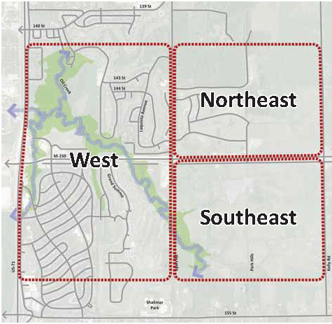
Study Area
The Missouri 150 Highway corridor through Grandview is a two mile corridor extending east from the interchange with US-71 highway/Interstate 49 to the city limits at Kelly Road. The study area for this Plan extends approximately one-half mile north and south of 150 Highway. The study area is bisected by Byars Road, which divides the area into an east and west area.
The western subarea contains most of the current development along the corridor, including the commercial development around the White Avenue intersection, Grand Summit apartment complex, and the Belvidere and River Oaks subdivisions.
The eastern subarea is mainly undeveloped. The main development activity in this subarea has been the Sunrise Farms development. The majority of the land is undeveloped and held in large parcels.
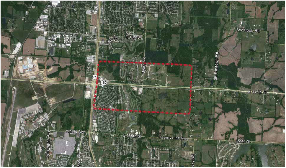
Figure 2: Study Area Map
Use of this Document
This Plan identifies ways to implement a sustainable, long-term community revitalization supported through an increased tax base, by establishing an overall vision for development along the 150 Highway corridor and identifying the tools necessary for achieving the vision over time. The Plan may be used by decision makers to support land use, infrastructure, and development review decisions; by property owners to identify uses for land; and by developers to clarify the desired character for new buildings.
The Plan is divided into three components:
•
Framework Plan - This document establishes the overall scheme for development of the 150 Highway corridor, including the transportation and open space networks and land uses.
•
Implementation Plan - This document describes the methods and tools the City will use to achieve the vision described in the Framework Plan.
•
Design Guidelines - This document provides guidelines for both the private and public realms.
Public Involvement
The unique potential of the M-150 corridor means that it will have an impact on Grandview beyond those who live, work, or own property in the corridor study area.
The Community
In order to engage the Grandview community, the project team held two community workshops. The first workshop, held in July 2011, engaged the community in determining the appropriate character for development along the corridor. Community members identified both desirable and undesirable characteristics through a visual preference exercise.
The second workshop, held in November 2011, presented a draft framework for future development, including transportation, open space and trails, and land uses. Feedback was used to refine the frameworks presented in this Plan.
Business and Development Stakeholders
Without the support of business and development stakeholders, this Plan is unlikely to come to fruition. In order to capture their feedback and knowledge, a series of focus group meetings were held with targeted stakeholders, including local businesses, key property owners, and development professionals. These meetings, held in May, July, and September 2011, covered market demand along the corridor, development constraints and opportunities, and desired development characteristics.
City Staff
Key City staff members participated in a technical assistance and feedback role.
A. - Development Context
Market Overview
A market analysis report was completed for the study area and is located in the appendix to this document. The City of Grandview experienced 1 percent of total growth in households in the two decades beginning in 1990, reaching 9,970 in 2010. During this same period, Jackson County grew nearly 9% and the region grew 27%. Grandview's household growth is projected to increase almost 14% to 11,300 by 2040. Much of the residential and commercial growth area outlined in the City's Comprehensive Plan is planned for the M-150 corridor area.
To fuel new growth along the corridor, development catalysts are needed to support new large-scale development. Two new large employment centers are planned in the near future. The National Nuclear Safety Agency (NNSA) is relocating to a new 1.1 million square foot facility on M-150 to the west of US-71 with up to 2,700 employees. Just south of the NNSA site is the CenterPoint-KCS Intermodal Center ("CenterPoint"). This 1,300-acre multimodal distribution hub will eventually house 5 million square feet of distribution space and up to 2,000 employees.
Historical development patterns both in the Kansas City region, as well as throughout the country, show that retail follows rooftops. In the context of new construction and greenfield development, residential delivery typically occurs first, followed by retail construction once a sufficient threshold or concentration of households exists. Regional retail demand is being met by Summit Fair and SummitWoods Crossing in Lee's Summit, and demand for general merchandise is met by supply at Truman Corners. The opportunity for retail should improve as the area experiences more household growth and a higher daytime population associated with the new employment centers west of US 71. This development will create higher daytime population will be significantly higher, which will boost demand for restaurants and services, and business-driven hospitality demand could support new hotel development.
Issues
Grandview benefits from easy access to the metro area, a large park network, affordable housing, and a small town feel within a suburban setting. The M-150 corridor has been targeted as an area of future growth opportunity for the City. The area is the last large developable area with direct regional access. The manner in which this key area develops will determine the future quality of life for all of Grandview's residents and businesses. In many ways this area is a blank slate to create a new development pattern along the highway; a pattern of new compact, mixed-use sustainable development with a common theme and identity. This style of development could focus on a mix of residential, commercial and office spaces, and be a self-sustaining place with new schools, trails, open space and other community services and amenities. A vision for redevelopment requires addressing the issues in detail.
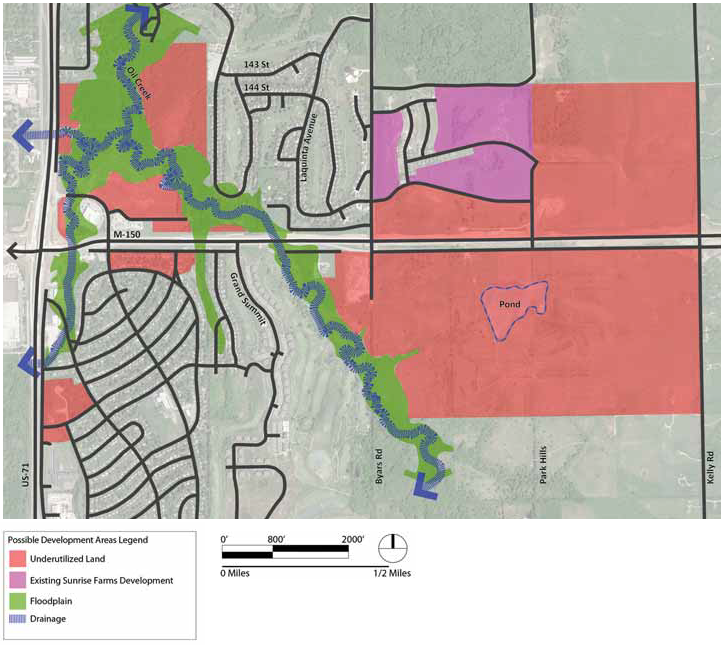
Figure 3: Possible Development Areas
M-150 Corridor: The corridor was recently expanded based on its significance as a regional transportation facility, and is sufficient to handle existing and future traffic volumes and provide improved ingress and egress along a series of frontage streets. These improvements, along with the improved interchange at US 71, and the conversion of US 71 into an interstate highway, will attract new regional and national attention for development.
Vacant land: The M-150 corridor offers some of the largest contiguous tracts of undeveloped land in Grandview, primarily at the northeast corner of US 71 and M-150, and north and south of M-150 between Byars Road and Kelly Road. A variety of parcel sizes present an opportunity to configure growth in phases. The natural rolling topography of the landscape provides an opportunity to frame views, focus entry points and organize development into compact patterns based on topographical variations. Creeks and open spaces extend through the project area and could be captured as an asset for existing and future development.
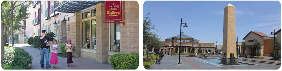
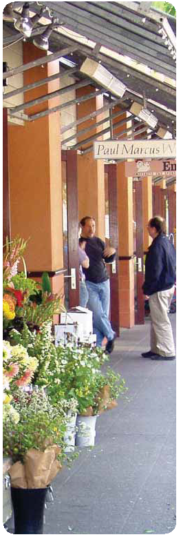
Sense of Place: The character of the M-150 corridor is lacking in a cohesive identity and sense of place. Instead of a destination, the area is often overlooked as a pass-through to reach areas outside of the corridor. Integrated development standards and aesthetic improvements could lead to a unique place in the region.
Local development patterns: Grandview's boom years occurred in the 1950's through 1970's, with a majority of neighborhoods developed 40 to 60 years ago. While neighborhoods are well kept, the housing stock and infrastructure has begun to deteriorate. Similarly, the historical development pattern from that time period emphasized sprawling residential development patterns with curvilinear streets and limited connectivity. Land uses types were intentionally separated from each other with commercial uses focused on major corridors and residential uses in outlying areas. Neighborhood residents must meet their daily needs in other parts of the City, leading to an unsustainable development pattern. A new framework is needed that incorporates more sustainable mixed-use patterns.
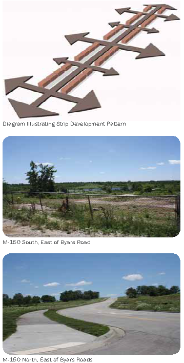
Strip development pattern: The existing corridor development pattern is primarily automobile-oriented with linear strips of uses. Wide building setbacks and surface parking along the street edge discourage a well-defined streetscape. The auto-oriented focus limits multimodal connectivity and detracts from a pedestrian-scale environment. Businesses benefit from direct corridor access, but have little relationship with each other or with surrounding development.
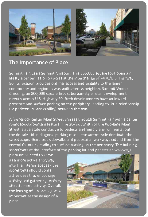
Regional competition: The M-150 corridor currently lacks competitive advantage for retailers to locate here. The retail market is generally weaker than the rest of the region, and numerous major shopping destinations are located within the market area (Centers in Leawood, Belton and Lee's Summit are examples, along with Grandview's Truman Corners). New development along M-150 will need to be high-quality to compete against larger regional centers. According to the Urban Land Institute (ULI), the most promising retail formats in the coming decade include mixed-use town centers with office and residential uses, neighborhood/community shopping centers and urban entertainment centers with movie theaters.
New employment: Ongoing development is increasing the amount of nearby employment. The most important employment center development is the development of the new National Nuclear Security Administration facility at 150 Highway and Botts Road, which will bring approximately 2,700 new employees to the M-150 corridor, with the first of these employees coming in late 2012.
Truman Corners: The City of Grandview is currently engaged in the redevelopment of the Truman Corners shopping center on the north side of the community. This center, one of the original suburban shopping centers in the region, experienced a decades-long decline that was highly visible to traffic passing it along US-71. Unfortunately, this visibility allowed the deteriorated Truman Corners to become the image of Grandview for many people in the Kansas City metro. The redevelopment of this area creates both the opportunity to rehabilitate Grandview's visual image from US-71, but also a potential competitor to development along M-150.
Number of households: The lack of development that provides an opportunity to define the future character and development framework also means that there are few households in the immediate neighborhood of the corridor. Because many retail uses depend on nearby households to support businesses, the small number of households may limit the desirability of the corridor for retail tenants in the short term.
Existing demographics: Grandview's demographic characteristics differ from surrounding communities. The most significant difference in terms of market demand and development impact is the city's lower household income level; when compared to neighboring communities such as Belton, Raymore, and Lee's Summit, Grandview households have a significantly lower median income, as measured by the US Census Bureau. However, Grandview is also younger than neighboring communities. Grandview and Belton are both considerably younger than the US median age and younger than other communities in the region.
Zoning: A series of steps to secure future development on vacant parcels south of M-150 will be needed, including rezoning. The area extending from Byars Road east to Kelly Road is zoned Agricultural, which will not support future development.
Utilities: Parcels north of M-150 include water, but lack sewer east of Byars Road. Vacant parcels south of M-150 lack sewer and water, which will require future infrastructure investment.
B. - Creating the Vision
Corridor Vision
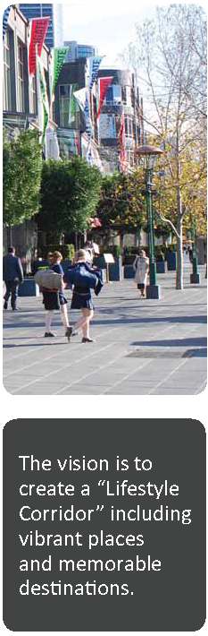
The vision for the M-150 corridor is for it to be Grandview's "Lifestyle Corridor;" a unique regional destination that provides a variety of jobs, housing choices, recreational opportunities and community services for residents and visitors. The vision recognizes that development in the corridor will evolve over time and may not occur in a single development cycle. The corridor will transition from auto-dominated, strip development to pedestrian-oriented, compact development with an emphasis on creating nodes separated by open space. The framework will encourage today's development to occur in a manner that supports the desired future, even if that future is many years away. The corridor's relationship with Grandview will improve and become a feature that benefits the community by encouraging a new, interconnected, community and region-oriented development pattern.
Stakeholders repeatedly expressed a desire to create a "sense of community" with strong schools, safe neighborhoods, and good accessibility to jobs. For the City to provide this quality of life, it is essential that the municipal revenues increase to accommodate rising costs. Communities with very high percentages of residential uses have an increased challenge to maintain revenue streams while relying upon traditional sources such as ad-valorem tax revenues. This undermines quality of life, and contributes to decline.
It is possible that the M-150 corridor could develop as a strong and sustainable economic engine and provide higher revenues than previously approved development plans for this area. By mixing uses, increasing density, the M-150 corridor could become a regional destination; a place where people can live, work, shop and play. Increased densities could leverage a higher tax base and provide the community with the financial resources required achieve and improved quality of life.
Ultimately, the drive along the M-150 through Grandview will provide a range of experiences that can be interpreted in the physical design of development throughout the corridor. This corridor will emphasize its unique topography, and offer defined views where the rights-of-way increase in slope, and offer expansive views of the region as the roadway crests. On a smaller scale, the corridor passes under the US-71 bridge which will serve as a landmark and gateway. Through the journey, the corridor passes along streams and open spaces, which are amenities to local neighborhoods. These experiences provide inspiration that can form the design of elements at the scale of the entire corridor and at smaller neighborhood scales.
To achieve this integrated vision will require new development to attain higher densities than currently exist in the City. If the M-150 corridor develops at current densities it will only add 450-650 new homes that can possibly support 50,000 to 90,000 square feet of additional commercial. Given the size of the opportunity along the M-150 corridor, this would result in a highly underutilized development scenario given the range of assets, including transportation and new employment. To create a destination place will require upwards to one million square feet of mixed use development. To provide catalytic growth in this corridor, new development will need to add between 2,000-3,000 new homes that can support between 750,000 to over 1.1 million square feet of commercial development.
Vision Themes
Supporting the Vision are "vision themes" and planning principles. Each theme describes qualities and characteristics that stakeholders would like to see in the corridor, and focus on increased housing and successional development. Successional development is a term that refers to a desired development pattern that may take multiple development cycles to occur. Although some retail will be viable as employment and households increase in the next 5 to 10 years, market forecasts suggest that the study area demographic profile may be insufficient for lifestyle retail development in the short term. Each development cycle needs to address the current market while preserving opportunities for efficient future redevelopment.
Sustainable design is a priority for Grandview and the M-150 corridor. Sustainability practices may come in many forms and scales, from site-level design to building efficiencies. Each should seek to benefit the social, environmental and economic functions of a place.
Five specific vision themes related to housing and successional development include:
Mixed use Neighborhoods
•
Corridor densities should be increased and include a vibrant mix of residential, civic, office, and retail uses.
•
Underutilized buildings and parcels should be redeveloped to contain a mix of uses.
•
Neighborhoods along the corridor should be revitalized in accordance with accepted neighborhood plans and ordinances to ensure high-quality development with a diversity of housing choices.
Open Space/Natural Landscape
•
Parks and open spaces should be connected to regional parks and destinations through a bike and pedestrian trail system.
•
Corridor topography should be maximized by framing views and shaping edges.
•
Streams, water bodies and open space should be enhanced as neighborhood amenities and recreational opportunities.
Memorable Places
•
Corridor gateways at US-71 and Kelly Road will identify this corridor as a special place and destination.
•
Mixed-use development patterns with civic uses incorporated will help strengthen the corridor and set it apart from other regional destinations.
•
Parks and open spaces should support a variety of events and activities.
Mobility
•
Connect to existing and future development through frontage streets which then link to a grid of local streets and backage streets. Consider traffic signals where needed to ensure full access.
•
North/south connectivity across the corridor is important and should be maximized.
•
Multi-modal connections (bicycle, transit and pedestrian) should be integrated with existing and future land use.
•
Corridor streetscape areas should be designed with consistent materials to ensure an enjoyable and safe experience for pedestrians.
Sustainability
•
Develop compact, walkable neighborhoods that reduce reliance on vehicular trips and reduce net energy needs.
•
Incorporate lifecycle costs into the decision-making process for purchase of materials
•
Preserve contiguous open spaces for environmental corridors and recreation.
•
Minimize reliance on ground water use by implementing water conservation practices.
•
Approve development applications that integrate Grandview's long-term development vision.
Evaluation Criteria
The vision themes described above were transformed into evaluation criteria. Evaluation criteria assisted in the development of approaches and were used to compare alternative approaches. Sixteen criteria are listed and ranked based on order of importance through input received by stakeholders and officials. The most important criterion was formation of mixed use places, including regional retail, office and residential uses that form destinations. Walkable, safe and inviting neighborhoods, along with civic gathering places, housing choices and a unified aesthetic theme all ranked highly as well.
Figure 4: Evaluation criteria
Planning and Development Principles
Based on the development themes and ranking of the elements, three planning and development principles have been defined to guide development along the corridor. These principles, together with the development visions themes, are transformational ideas that form the foundation of the corridor development framework and provide an opportunity to create a distinctive place in the city and the region.
Create destinations along the corridor
For the corridor to be successful it must offer destinations, - not simply an endless strip of single use buildings. It needs places where people want to be and a mix of community and regional activities and uses. Development should be concentrated at key locations to provide focus and create destinations in the corridor. It is important to create attractive streets that connect the destinations to allow people to easily and pleasantly travel between the development centers.
Connect to the community
The development along M-150 needs to connect to and be compatible with the existing character of Grandview. Building heights should be compatible with the existing development, and the activities that occur in those buildings should be neighborhood-oriented as well as corridor-serving. Amenities that will be installed along new streets should be extended into the existing community as appropriate to create physically and aesthetically connected places.
Capture a high percentage of vehicles trips within the corridor
The expansion of M-150, and the development of new destinations along the corridor, will bring new trips to the area. It is more desirable for these trips to stay close to the corridor rather than dispersing into the surrounding area, in order to support denser development along the corridor and reduce the spread of more intense uses into the existing nearby neighborhoods. Additionally, creating denser development in the corridor will help to create focal points along the corridor, and developing in a denser manner is a more efficient use of land and infrastructure resources.
Planning and Development Strategies
To implement the three foundational Planning and Development Principles presented above, a series of strategies have been crafted. The following overall planning strategies serve to further guide the character and quality of development in the corridor and should be utilized into all new development.
Successional Development
Successional development is a concept acknowledging that achieving a desired development pattern and urban form may take multiple development cycles and that each development cycle must address the requirements of the current development market while preserving opportunities for efficient future redevelopment. Successful successional development embraces three design and development principles which should be considered when Grandview evaluates development proposals along the M-150 Corridor.
Establish a long-term development vision and framework. Based on the corridor vision, the successional framework locates the primary multimodal circulation network and identifies a possible future street and block system. When possible, future street easements should be located along existing property lines so that new streets can be constructed with future development.
Provide infrastructure for more intense future development. Upgrading infrastructure is costly and can be a significant deterrent to achieving redevelopment. Over-sizing some infrastructure elements where more dense development can be realized within the next one to two development cycles may facilitate desired redevelopment more quickly and take the desired future form based on the planned vision.
Locate buildings clear of possible future road easements. The location and size of buildings on parcels can either facilitate or impede redevelopment. To increase the likelihood of successful redevelopment, buildings should be located and designed to accommodate a planned street network based on the long-term vision. When buildings are located in the center of a parcel, future subdivision of the parcel can be difficult from a land use and cost perspective. If it is possible to subdivide the parcel, buildings centered on a parcel can result in undersized parcels and scale issues, which can be a deterrent to redevelopment and do not fulfill the development vision.
Nodal Development Pattern
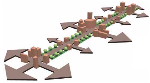
Diagram Illustrating Nodal Development Pattern
For the corridor to be successful, it needs to host many destinations. It needs to have places where people want to be and include a mix of community and regional activities and uses. Nodal development, which concentrates development at key locations, will provide focus and create destinations in the corridor. To facilitate access between the development centers, it is important to create attractive streets that connect the destinations.
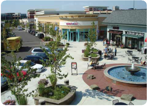
Compact development creates vibrancy
Compact Development Pattern
In addition to creating nodes, the overall development pattern will need to become more compact to sufficiently create an environment that can support walkability, higher densities, and higher utilization of infrastructure with increased municipal revenues. This plan encourages a compact development style that envisions future development as three districts that are connected by multi-modal streets and include a mix of uses to meet daily needs. Compact development refers to a design intent that locates homes on smaller lots and within walking distance to pedestrian-oriented commercial and office destinations. This pattern of development can help to lower infrastructure costs by making roadways narrower and utilities shorter. It can also help preserve valuable open spaces, limit sprawl and increase neighborhood cohesiveness and public health through encouraging walking/bicycling and social interaction.
Stormwater Management
There are two core issues to address when handling stormwater: 1) volume and timing of runoff (detention and conveyance) and 2) contaminants carried in the water (water quality). Addressing the core issues of stormwater throughout its cycle in an urban setting maximizes sustainable regeneration of the resource and minimizes the impact to the built environment and urban design of place. Techniques must be utilized at the source point for cleaning the water as well as using land-based solutions to handle stormwater detention and conveyance.
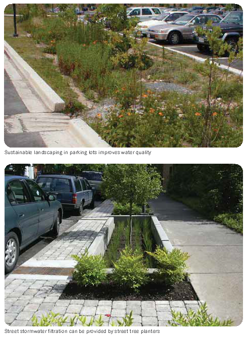
Development opportunity sites along the M-150 corridor should be aggregated to address larger regional stormwater issues, rather than addressing stormwater on individual parcels. This aggregation allows for stormwater to be addressed in areas less prominent for development and helps to congregate appropriate land use in an urban form, allowing for highest and best use based on market conditions. It also allows for an opportunity to solve historic stormwater issues in existing, adjacent neighborhoods, which can aid in building community support for redevelopment.
Detention ponds, bioswales, infiltration trenches, and sustainable pavements (such as pervious) should be utilized throughout redevelopment sites and integrated into the built environment, public rights-of-way, and within the open space system. Usage of hybrid subsurface stormwater infrastructure systems to convey loads unable to be addressed through low-impact development should be considered. Park systems can receive large stormwater events and detain, release, and convey water through a greenway in a regional park system. These management elements should be designed to coexist into the park character and can be used as amenities for passive and active recreation, while reducing the need for more expensive solutions.
Low-Impact Development
Low-impact development practices are encouraged to be integrated into all new development. When these practices are implemented on a neighborhood or district level the impact to the environment and public infrastructure can be greatly reduced. Low Impact Development (LID) offers several techniques including stormwater harvest, infiltration to restore the natural recharge of groundwater, biofiltration or biorientation (e.g., rain gardens) to store and treat runoff and release it at a controlled rate to reduce impact on streams and wetland treatments. This stores and controls runoff rates and provides habitat in urban areas. Curb modifications for at-source retention are recommended to collect run-off water into bioswales, and provide at source water quality. Permeable pavements should be used to enhance the streetscape and contribute to the character while serving as LID. Green roofs are another potential solution. These applications largely address water quality at the point source prior to connecting into the larger system for conveyance and detention. All techniques should be evaluated to understand which best address the climate and geographic conditions of the site.
Planting beds increases permeable surfaces
C. - Development Frameworks
Development frameworks should be used by the City to communicate the urban form new development will take based on the vision discussed in Part B: Creating The Vision. Frameworks include land use, transportation, open space and trails, and utilities and energy.
Land Use
The land use vision concentrates growth at the primary developable sites along the corridor. Three districts of redevelopment are envisioned: one north of M-150 between Byars Road and Kelly Road, one south of M-150 between Byars Road and Kelly Road, and one northeast of US-71 and M-150 (Figure 5). The three are intended to be compatible with and relate to each other, but will differ in their character, land use mix and circulation patterns.
The largest opportunity sites along the M-150 corridor include the undeveloped parcels between Byars Road and Kelly Road. The plan for this area is to create new and active destinations that people are drawn to for live, work and play. Two districts are envisioned: north of M-150 is a local district that connects with existing neighborhoods; south of M-150 is a regional district attracting new users. Both districts contain a vibrant mix of residential, commercial and office uses, but at different scales and at different densities. Both districts are designed to work in harmony to draw economic development to the area. Common themes amongst these areas include:
•
Commercial, office and retail uses will be built at densities sufficient to create an urban environment, particularly around Park Hills Road as the gateway Main Street and along the backage streets.
•
The neighborhoods are designed to form a unique sense of place, one that is walkable and well connected to surrounding land uses.
•
The backage streets form the connectivity framework for both districts. These streets should be multimodal and inviting.
•
An interconnected system of parks and trails will help create a distinctive identity for the districts, one that facilitates circulation amongst diverse uses.
Moving east along M-150 from Byars Road, proposed uses could transition from Mixed-Use Commercial, to Entertainment and Retail at Park Hills Road, and then lower intensity office uses as one approaches Kelly Road. Park Hills Road would serve as the primary node and entryway to development north and south. Lower intensity office uses to the east would respect the more rural character of the area and help reduce overall traffic demand. Land use would be organized to maximize the natural amenities of the area including rolling topography, ponds, streams and trails.
Northeast: M-150 - Byars Road to Kelly Road (North):
New development will complement the existing residential development along the corridor through multimodal connections and linkages. The central focal point within the proposed development is a new commercial neighborhood center surrounding Park Hills Road. This area could include a mix of small and medium format retail, restaurants and destination entertainment such as bowling and music venues. The intent is to create an "18-hour place" where one can grab a morning cup of coffee, a lunchtime sandwich or evening meal. Office uses will range from three to four-story or the 60,000 to 90,000 square foot range. A two-way backage road is proposed parallel to M-150 to provide the primary access into commercial and office uses situated along M-150. This commercial street will provide the primary east-west access from Park Hills Road and will operate at slower speeds with on-street parking to calm traffic.
A park is proposed as a central gathering space and community recreational amenity west of Park Hills Road. The park would maximize existing natural features by incorporating an existing stormwater pond. The park serves as the front door to the surrounding residential neighborhood with an interconnected network of slow-speed, walkable streets and alleyways. To ensure a diversity of housing types, styles and income levels, a robust mix of small-lot single family residential and carriage homes, townhomes, and small scale multifamily products are proposed to produce an average density between 6 — 10 units to the acre. Flexibility in form and scale is the goal; providing for the community at every stage in life is important, from singles to families to the elderly. Residential uses should transition from the highest density at Park Hills Road to lower densities transitioning to the large open space area farther north. An elementary school is anticipated northeast of the park to serve the surrounding neighborhood.
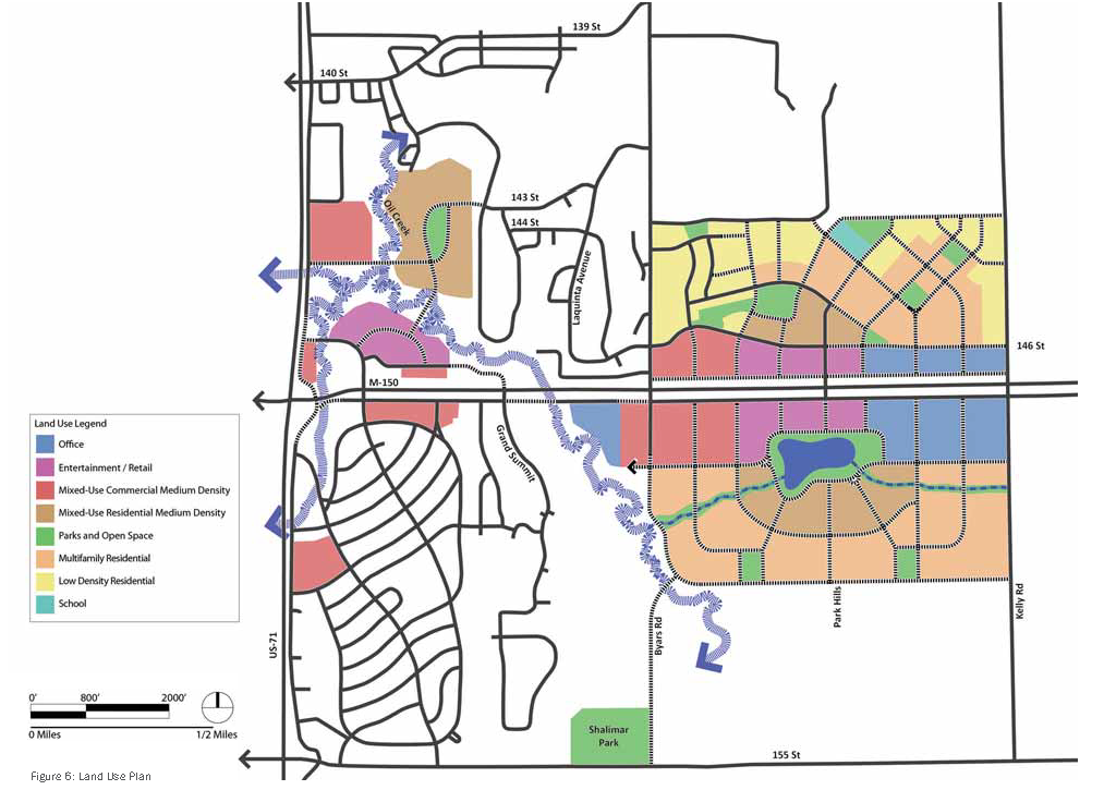
Southeast: M-150 - Byars Road to Kelly Road (South):
A regional destination is envisioned south of M-150, with uses organized around an improved drainage pond that becomes a community feature. An extension of Park Hills Road could serve as the Main Street into the development, intersecting with a backage road around the pond. A mix of destination entertainment, retail and office uses would front the pond.
The commercial area from west to east (Byars Road to Kelly Road) could include both large format and medium format retail. Closer to Park Hills Road and the pond are smaller shops and restaurants, a 30,000 square foot grocery store, and medium format retail. These uses should be connected across parking fields and building frontages to the Main Street retail/restaurant block. From the east and along the pond and backage road, a cinema, restaurants and hotel are envisioned. Office buildings are intended between Park Hills Road and Kelly Road. Office could support corporate office users, or potentially a medical center. All have been organized along the backage streets to create a street edge that is in scale with the multifamily residential to the south.
Around the pond, higher density mixed-use residential are situated around the park-like setting. A curvilinear street pattern is proposed to respect the natural topography, enhance the rural setting and slow travel speeds. A series of streets radiate from the pond, intersecting with two neighborhood parks to the south. These block-sized parks provide an amenity for the neighborhood.
The density of the residential neighborhoods transitions from higher-density multifamily to lower-scale townhomes along the southern and eastern edges, achieving a gross residential density of approximately 20 — 25 units per acre, and includes for-rent and for-sale housing products. Setbacks are envisioned along Kelly Road to respect the existing rural character and alleviate traffic loads. A sense of place is captured throughout the neighborhood by focusing parking within the center of the blocks and orienting buildings onto street edges.
West: US-71 and M-150:
The area northeast of US-71 and M-150 benefits from highway visibility and access to the Oil Creek greenway amenity. This area is envisioned as an entertainment/retail area with dining establishments oriented to the greenway amenity. Mixed-use residential in this area could organize around parks and the greenway with connections to existing residential uses to the east. As redevelopment occurs along the corridor, additional pockets of mixed-use commercial at strategic areas along M-150 would help create a place along the corridor.
Land Use Typologies
The following pages include land use typologies for office, entertainment/retail, mixed use commercial and residential, and open space. Each typology includes characteristics that should be used to guide development.
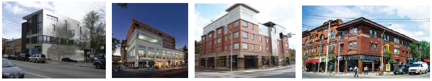
Office Land Use Typology
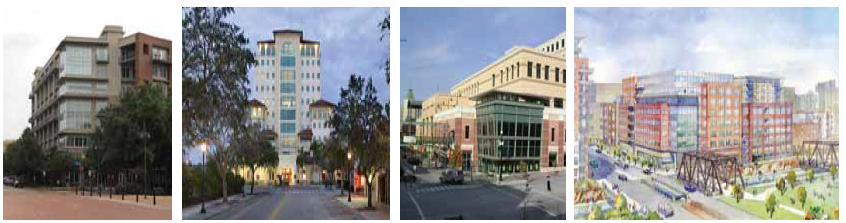
| OFFICE LAND USE CHARACTERISTICS | 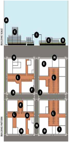 |
| Density: 4 — 14 story buildings and 50% Site Coverage | |
| Land Use Mix: Office only | |
| Pedestrian: Wide walks, logical connections and streetscape amenities | |
| Community Center: Attractive public spaces and public gathering areas to create community | |
| OFFICE SITE CRITERIA | |
| Ⓐ Continuous ground-floor commercial / office activates streetscape | |
| Ⓑ Structured parking levels above ground floor or center of block | |
| Ⓒ Office | |
| Ⓓ Building setbacks transition building heights | |
| Ⓔ Buildings oriented to street and street corners, 70% building facade transparency | |
| Ⓕ Surface parking located at the interior of blocks | |
| Ⓖ Alleys provide service access for buildings | |
| Ⓗ On-street parking required except for timed loading zones | |
| Ⓘ Mixed-use parking garage with ground floor office uses | |
| Ⓙ Urban plazas provide space for pedestrian amenities | |
| Ⓚ Minimum 12 foot sidewalk from curb to building face | |
| Ⓛ Structured parking located at center of block, shielded by office buildings | |
| Ⓜ Street width maximum width 52 feet; with-on street parking |
Entertainment/Retail Land Use Typology
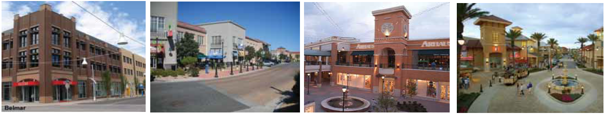
| ENTERTAINMENT / RETAIL LAND USE CHARACTERISTICS | 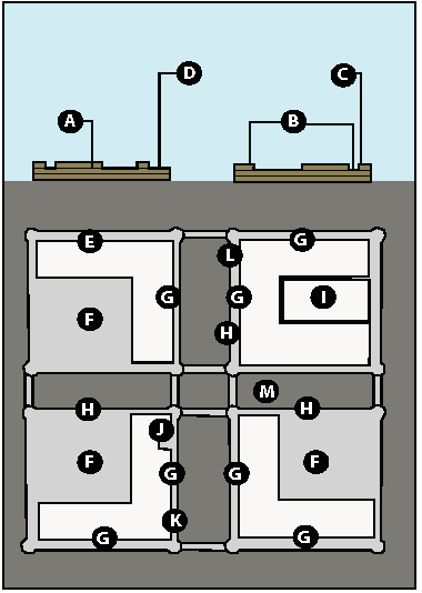 |
| Density: 2-3 story buildings and 50% Site Coverage | |
| Land Use Mix: Retail and commercial only | |
| Pedestrian: Wide walks, logical connections and streetscape amenities | |
| Community Center: Attractive public spaces and public gathering areas to create community | |
| Complementary Uses: Mixed-use commercial and mixed use residential | |
| ENTERTAINMENT / RETAIL CHARACTERISTICS | |
| Ⓐ 2 — 3 stories of retail / entertainment uses | |
| Ⓑ Differentiated building heights provide for a more interesting streetscape and allows light to reach the street | |
| Ⓒ Maximum height at corners provides a visual reference for pedestrians and motorists | |
| Ⓓ Building setbacks transition building heights | |
| Ⓔ Buildings oriented to street and street corners on at least 2 sides of the block, 70% building facade transparency | |
| Ⓕ Surface parking located behind buildings away from primary street frontages | |
| Ⓖ Defining primary streets to front buildings and entrances allows for surface parking on secondary streets | |
| Ⓗ On-street parking required except for timed loading zones | |
| Ⓘ Parking structures should be located at the interior of blocks | |
| Ⓙ Urban plazas provide space for pedestrian amenities | |
| Ⓚ Minimum 12 foot sidewalk from curb to building face | |
| Ⓛ Develop streetscape characters that define the district as a destination and place | |
| Ⓜ Street width maximum width 52 feet; with-on street parking |
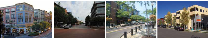
Mixed Use Commercial Land Use Typology
| MIXED-USE COMMERCIAL MEDIUM DENSITY LAND USE CHARACTERISTICS | 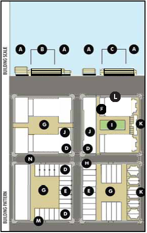 |
| Density: 2 — 5 story buildings and 70 — 80% lot coverage | |
| Land Use Mix: Ground floor retail or office uses required, neighborhood services, commercial above and minimum ground floor height of 16' | |
| Pedestrian: Wide sidewalks, convenient connections and community amenities | |
| Community Character: Flexible community gathering spaces, civic land uses, street amenities and neighborhood services | |
| Complementary Adjoining Uses: Mixed-use residential medium density | |
| MIXED-USE COMMERCIAL MEDIUM DENSITY SITE CHARACTERISTICS | |
| Ⓐ Continuous ground-floor retail / office activates streetscape / additional stories at corners helps to define intersections | |
| Ⓑ Less stories at mid-block allows sunlight to reach the street and provides variation along the building frontage | |
| Ⓒ Less stories at mid-block allows sunlight to reach the street and provides variation along the building frontage | |
| Ⓓ Mixed-use buildings / ground floor retail oriented to street corners | |
| Ⓔ Commercial units oriented towards streetscape allow more "eyes on the street" for enhanced security | |
| Ⓕ Alleys provide service access for buildings and provides a transition area for building scale and use | |
| Ⓖ Surface parking to the rear or side of building | |
| Ⓗ Curb extensions with stripped crosswalks | |
| Ⓘ Landscaped area provides a break area for workers | |
| Ⓙ Reduced setback and similar architectural styles on either side of the block balance and unify streetscape | |
| Ⓚ Multi-family mixed use units with articulated facades complimentary to mixed-use commercial units | |
| Ⓛ Block circumference - 2,000 linear feet maximum | |
| Ⓜ 6 foot wide minimum sidewalk separated from curb with linear planting area suitable for trees and streetscape amenities | |
| Ⓝ Local street width: 38 feet maximum curb to curb. |
Mixed Use Residential Land Use Typology
| MIXED-USE RESIDENTIAL MEDIUM DENSITY LAND USE CHARACTERISTICS | 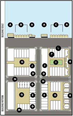 |
| Density: 12 — 20 units per acre, 2 — 5 story buildings and 70 — 80% lot coverage | |
| Land Use Mix: Ground floor retail or office uses required, neighborhood services, residential above and minimum ground floor height of 16' | |
| Pedestrian: Wide sidewalks, convenient connections and community amenities | |
| Community Character: Flexible community gathering spaces, civic land uses, street amenities and neighborhood services | |
| Complementary Adjoining Uses: Mixed-use commercial medium density | |
| MIXED-USE RESIDENTIAL MEDIUM DENSITY SITE CHARACTERISTICS | |
| Ⓐ Continuous ground-floor retail / office activates streetscape | |
| Ⓑ Single-family attached townhouses with attached parking in rear | |
| Ⓒ Single-family attached townhouses with attached parking in rear | |
| Ⓓ Mixed-use buildings / Ground floor retail oriented to street corners | |
| Ⓔ Residential units oriented towards streetscape allow more "eyes on the street" for enhanced security | |
| Ⓕ Alleys provide service access for buildings and provides a transition area for building scale and use | |
| Ⓖ Surface parking to the rear or side of building | |
| Ⓗ Curb extensions with stripped crosswalks | |
| Ⓘ Tot - lot/play area | |
| Ⓙ Reduced setback and similar architectural styles on either side of the block balance and unify streetscape | |
| Ⓚ Multi-family units with articulated facades complimentary to attached single family units | |
| Ⓛ Block circumference - 2,000 linear feet maximum | |
| Ⓜ 6 foot wide minimum sidewalk separated from curb with linear planting area suitable for trees and streetscape amenities | |
| Ⓝ Local street width: 38 feet maximum curb to curb. |
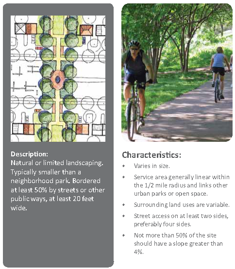
Open Space Land Use Typologies ;bo; Greenway
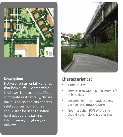
Landscape Buffer
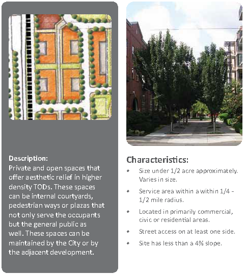
Private/Public Open Space
Stormwater Garden Facility
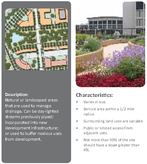
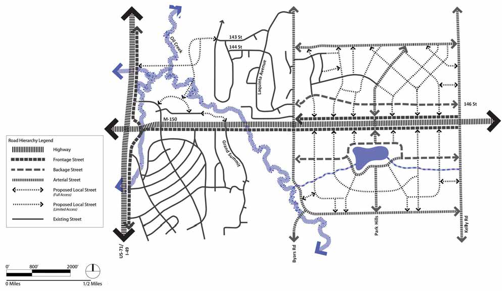
Figure 7: Road Hierarchy Plan
Transportation
The overarching transportation goal is to help people move freely along and across the corridor, and throughout the City. Secondary east-west connections are needed to provide access for new development and reduce congestion on M-150. New streets should link existing residential areas with new places. By expanding connectivity, the entire Grandview community benefits from better circulation and a more interconnected street network. From the perspective of pedestrians, the M-150 corridor is excessively wide and may act as a barrier to north/south pedestrian movement. The design of corner development and the intersection will be important to creating a pleasant street environment. The highway should be viewed as a conduit for travel amongst corridor nodes of activity and to destinations outside the corridor. Opportunities exist to link residents to transit by constructing interconnected trails and multi-modal streets. Objectives for development of the transportation network include:
•
Create a connected street network;
•
Provide green transportation strategies;
•
Maximize multimodal connectivity;
•
Adopt access management policies; and
•
Encourage multiple shared parking areas.
Connected Street Network
A system of highway, frontage streets, backage streets (also called reverse access streets), arterial and local streets will provide the backbone for existing and future development. This network, described in more detail in the Street Design section, includes four distinct street types other than the US-71 and M-150 highways:
•
Frontage streets run parallel to M-150 and feed traffic to the highway at limited access points;
•
Backage streets run parallel to the highway, operating at slower speeds, and create opportunities to travel east-west through the corridor without entering the higher speed, lower access frontage streets or M-150 itself;
•
Arterial streets provide mobility between the backage and local streets to the highway and other arterials; and
•
Local streets encompass both collector and local streets.
US-71 and M-150 are the primary north/south and east/west vehicular corridors through the area connecting Grandview and the broader region. Development should include a system of frontage streets, which provide secondary highway access; backage streets, which provide east-west local connectivity; and local streets, which provide walkable, connected environments through and between places. Access control along the frontage streets is important to minimize curb cuts and ensure parking is situated at the rear of parcels. Byars Road, Park Hills Road and Kelly Road serve as arterial streets intersecting M-150, each with a different function:
Byars Road: Serves as a primary conduit of access north and south of M-150; this plan anticipates the eventual extension of Byars Road south to 155th Street. The two-lane street would curve to slow traffic speeds, and respect the natural topography and character of the area. Byars Road is envisioned as a green street/recreational corridor with sidewalks and multi-use paths that connect park facilities at 155th Street to the community recreation center north of M-150.
Park Hills Road: As the "Main Street" and primary entrance into development north and south of M-150, Park Hills Road is envisioned as a pedestrian-scale gateway. The two-lane configuration with sidewalks and bicycle lanes would access the commercial and residential area to the north and the pond-front destination area to the south.
Kelly Road: The existing rural character of Kelly Road is preserved in this plan. A gateway feature at Kelly Road and M-150 would signify the corridor as a special place and entrance into Grandview, but the overall function of Kelly Road remains unchanged.
Green Transportation
Providing for alternative modes of travel (walking, bicycling and transit) promotes healthy lifestyles and helps lower the impact of vehicular travel on the environment. This plan encourages green transportation through the design of a system of streets with bicycle lanes, sidewalks, provision for transit facilities, and open spaces with multi-use paths.
Green transportation practices are not limited to alternative modes. Designing streets and infrastructure through green methods means utilizing regional construction materials, recycled materials, elements with long-term durability and low-maintenance and energy-saving and/or renewable sources. The benefits are felt not only in health and the environment, but also in more cost-efficient maintenance and operations.
Multimodal Mobility
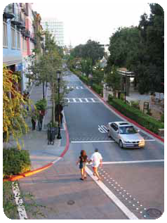
Sustainable places are those that encourage people to walk, bike, or ride the bus rather than take their personal vehicles. Each of the three subareas described earlier in this document need a circulation framework that maximizes opportunities for multiple mobility modes. Realizing this vision will require the provision of sidewalks, multiuse paths, bike lanes, appropriately-designed pedestrian and traffic lighting, landscaping, and signage. For example, pedestrian-scale lighting needs to be positioned over the sidewalk, rather than over the street. Improving sidewalk illumination can increase pedestrian traffic and enhance community safety. Landscaping can provide shade and generate visual interest to draw walkers down the sidewalk; that same level of visual interest can subconsciously slow down drivers. Pedestrian-friendly signage provides visual appeal and does not block sidewalks and walkways.
The urban design recommendations section of this plan further illustrates how mobility and development form are integrated to provide pedestrian friendly places, thereby encouraging multimodal use.
Specific multimodal recommendations include:
•
M-150 and its frontage streets should provide bicycle, pedestrian and transit (bus) connectivity. Intersecting streets should provide a well-connected system of bicycle and pedestrian facilities, particularly within future nodes of development. Sidewalks should range from 5 to 10 feet wide and streets should have an amenity buffer between the sidewalk and the roadway. The plan proposes the creation of bike paths on the backage and main north/south streets. Bike paths on the frontage streets are proposed when needed for connectivity.
•
Byars Road should be transformed into a green boulevard from approximately 139 th Street to 155 th Street, with sidewalks and multi-use paths that connect future development and recreational areas together.
Access Management Policies
Access management policies are critical to the successful functioning of a connected street network at regional and local scales. Signalized intersections along M-150 provide the primary access into new development along M-150 and are located at White Avenue, Grand Summit Boulevard, Byars Road and Kelly Road. A future traffic signal is envisioned at the intersection at Park Hills Road to provide additional north-south access and connectivity across M-150. The following principles provide access recommendations for streets and intersection design.
Access Principles
Frontage Streets provide secondary east-west movement and are envisioned to connect to arterial and local streets. Frontage streets could provide limited right-in/right-out access to mixed use development nodes through an improved entry access. However, the provision of access directly to individual developments and businesses is discouraged along frontage streets. Direct access should be provided primarily through local and backage streets.
Arterial Streets should be designed to distribute vehicles to other arterial and local streets. Similar to frontage streets, arterial streets could provide limited right-in/right-out access to mixed use development nodes through improved entry access, including landscaping, visual appeal, and provide multimodal access. However, the provision of access directly to individual developments and businesses is discouraged along arterial streets. Direct access should be provided primarily through local and backage streets.
Backage/Reverse Access Streets operate at slower speeds and should be designed to provide tertiary level of east-west mobility. With slower speeds, access can be provided safely and connect to local streets. Left and right turns can be provided to development areas through an improved entry area. Entry areas should include landscaping and design to be visually appealing and provide multimodal access. Shared access to multiple businesses or development from backage streets is encouraged and curb cuts should be separated by a minimum distance of 300 feet.
Local Streets provide primary access to businesses and developments and operate at slower speeds; between 25 — 30 miles per hour. Left and right turns should be provided to development areas through an improved entry area. Entry areas should include landscaping and design to be visually appealing and provide multimodal access. Shared access to multiple businesses or development from local streets is encouraged and curb cuts should be separated by a minimum distance of 300 feet.
Intersection Principles
The design of street intersections should consider the needs of vehicles, transit, bicyclists and pedestrians. Intersections should be designed to be as narrow as possible and limited in all conditions to a total of eight lanes or less when practicable. These conditions are required for appropriately scaled intersections for community design. A need for more turning movements is an indication that the connectivity network should be expanded, rather than the intersection being expanded.
Major Intersections include streets that intersect with 8 total travel lanes or more. A typical example is an intersection of two streets, each with 2 lanes in each direction and no dedicated turning bays. Major intersections should include crosswalks a minimum of 12 feet wide and include a pedestrian refuge area. Lane widths at intersections should be between 10 feet 6 inches and 11 feet wide.
Local Street Intersections include streets that intersect with 7 total travel lanes or fewer. A typical example is an intersection of two streets, each with 3 lanes: one lane in each direction and a center turn lane. Local street intersections should include crosswalks a minimum of 8 feet wide. Lane widths at intersections should be between 10 feet and 10 feet 6 inches wide.
Parking
Parking is an important component of the overall land use and transportation system. Parking influences the look and feel of a city and its neighborhoods, and thus it should be approached through a comprehensive strategy that plans for phased growth over time. Surface parking lots, in particular, tend to detract from the walkability of a place, promote auto-oriented development, and need to be sited carefully. In general, parking locations should be shared among multiple uses and areas, and be less prominent, located to the rear of buildings or in parking structures, if feasible.
North and south of M-150 between Byars and Kelly Roads, the ultimate parking strategy will transition from structured parking, to surface parking and then to on-street as the land uses decrease in density and intensity. South of M-150, the market may be more favorable for structured parking in the core areas, as this area will serve as a regional destination with place-based anchors.
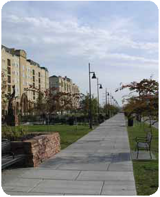
Open Space & Trails
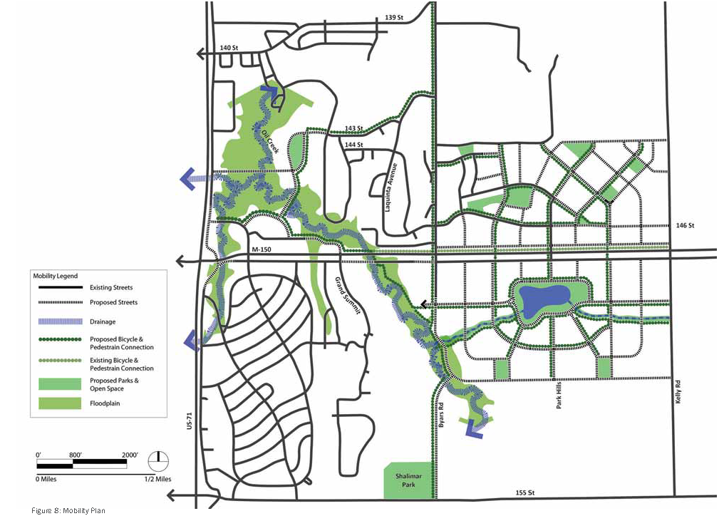
Open space and trails are intended to take the form of both passive and active spaces, each with a different form and function. Vegetative buffers along major transportation corridors will enhance roadway aesthetics and protect sensitive land uses. An interconnected network of green streets will provide both multimodal opportunities and stormwater management. A robust network of diverse open space ensures community benefit and signifies the corridor as a unique place. A system of parks, trails, greenways, pedestrian paths and plazas, waterways and stormwater drainage areas are proposed throughout the study area, as shown in Figure 8, followed by principles for creating sustainable open spaces and stormwater management.
Landscape Buffer: Landscape buffers are proposed along M-150, US-71 and Kelly Road to protect sensitive uses from highway noise and views. These buffers could enhance the aesthetics of the roadside and create a unified character. The buffers are punctuated at and around key intersections (US-71/M-150, Byars Road and Park Hills Road) to ensure visibility and enhanced ingress/egress onto frontage streets and local streets.
Green Streets: Green streets are intended to carry multiple transportation modes (walking, bicycling and transit) within an interconnected network of streets. Green streets are proposed within the development districts to link parks and open spaces together. They should serve as vegetated corridors with a mix of native plantings and include stormwater management devices (bioswales, vegetated strips, etc.).
Greenways and off-street trails: The Oil Creek greenway currently extends across the M-150 corridor. This greenway should be preserved and enhanced as an amenity for existing and future neighborhoods. Off-street trails through the greenway should link to the proposed system of green streets and neighborhood parks. Trails can connect residents to neighborhoods and commercial uses outside of the immediate study area (north and west). South of M-150, drainages flow into the existing pond, and could be transformed into landscaped natural corridors with walkways and bikeways along them. Connections to bikeways through street bridge crossings and at low-flow mid block crossings ensure continuity of access.
Natural open space/preserves (land): This corridor contains a mix of open spaces, the primary being the large expanse north of 139th Street including Meadowmere Park and lands to the east. High-quality open space should be preserved within development areas for passive recreation, green relief and wildlife.
Utilities & Energy
Provision of utilities will be critical as new development occurs along M-150. The current availability of utilities directly adjacent to M-150 could promote strip development north and south of the highway, unless utilities are organized and extended to support the entire developable areas. Major utilities needed include sewer and water. Additionally, to realize the vision set forth in this plan, a new substation may be required to supply energy. All new development should integrate effective stormwater management practices to utilize natural processes and reduce the need for more costly solutions.
Northeast Subarea
The lands east of Byars Road and north of M-150 have access to water but lack sewer. Sewer can be provided by extending the existing sewer from the subdivision. Some minor capacity increases will be needed to the east of the Little Blue Valley Sewer System (LBVSS) interceptor.
Southeast Subarea
The lands east of Byars Road and south of M-150 lack access to water and sewer. Sewer can be accessed from the LBVSS without any special conditions, and connecting to the interceptor which runs along Oil Creek. Water can be extended from a main along Byars Road running south from the existing tank. The water district is planning to develop a new tank in the section of land east of Kelly Road. Additionally, water may be access from the Belvedere area.
West Subarea
The lands north of M-150 and east of Oil Creek have access to sewer but lack water. Water may be accessed from adjacent subdivisions.
Integrate sustainable energy practices
The vision for new compact development along the corridor will require higher energy requirements per acre than typical development. A goal for new development along the M-150 corridor is to reduce the need for some energy requirements. When considering a carbon-reduced or carbon-neutral development project, it is critical to design, engineer, and specify buildings that minimize energy use. Reduced energy use can be achieved through a combination of passive and active system design measures.
Passive systems. In the context of passive solar building design, the aim is to maximize solar gain within the building in the winter (to reduce space heating demand) and to control it in summer (to minimize cooling requirements). Building orientation and form can affect the utilization of thermal mass that could be used to even out the fluctuations during the day and to some extent between days. Awnings, canopies, and street trees play an important role in providing effective responsive shading at low costs, reducing heat gains in roadways and buildings, and enhancing the streetscape of urban corridors. In direct solar gain systems, the composition and coating of the building glazing can also be manipulated to optimize the greenhouse effect, while its size, position and shading can be used to optimize solar gain. Solar gain can also be transferred to the building by indirect or isolated solar gain systems.
Active systems. Passive systems can be augmented with active solar design systems and can include photovoltaic cells, district energy, and heat recovery systems. Active systems tend to require higher levels of technology, tend to have increased costs, and can require specialized management to maintain. Active systems should be considered when possible, and evaluated based on a life-cycle cost basis rather than an initial capital cost basis.
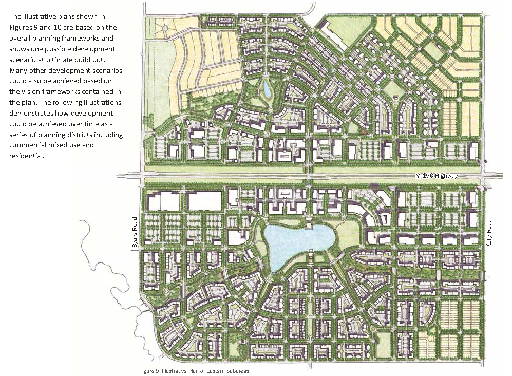
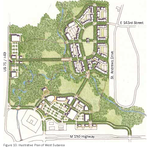
Figure 10: Illustrative Plan of West Subarea
Character Framework Plans
The M-150 development frameworks previously discussed represent an illustration and guiding principles to implement Grandview's vision for enhancing economic development along the corridor. MoDOT's expansion efforts in the corridor will help catalyze this transformation, but more definitive recommendations are required to achieve the vision set forth in this Plan. The character framework plans provide the guiding principles for the character of development the City of Grandview desires in this corridor. The plans are described in terms of Development Pattern Principles, including overall block sizes and building height, and Urban Design Principles, describing building frontage, view terminations, right-of-way treatments, landmarks, and sidewalks and bike paths. These plans shall be used when reviewing any development within this corridor to ensure long term compatibility for successional development, and compatibility of the goals and principles set forth in this plan.
Development Pattern Principles
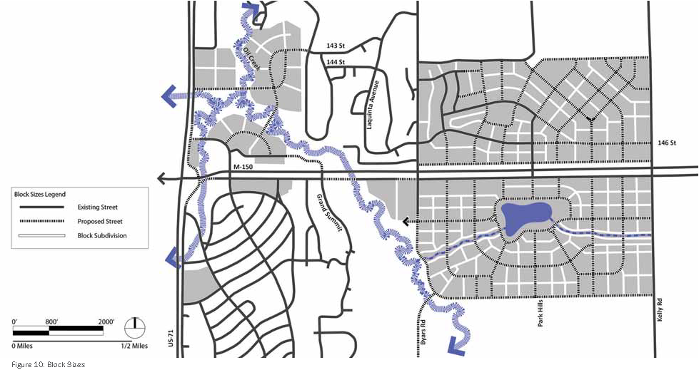
Block Sizes
The plan proposes that a compact development pattern be created in the study area, including an interconnected street grid pattern with development blocks sized for walkability and appropriate building orientation for street frontage. The maximum block perimeter should be approximately 1,400 — 1,600 feet and not exceed 1,800 feet. The maximum length of any block edge should not exceed 600 feet. Possible block sizes to be consider could be 340' x 340', 340' x 370', 300' x 600', and 400' x 400'. (Figure 10)
Building Heights
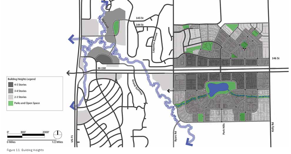
In order to ensure new development is compatible with existing development, the plan proposes different building heights along the corridor. The highest buildings proposed, between four and six stories, are planned for the blocks surrounding Park Hills Drive. Three to five story buildings are proposed along the backage streets within one half mile on each side of Park Hills Drive. Development outside of these areas is proposed to be two and three stories. This pattern provides development focus at Park Hills Drive and the associated planned amenities located both north and south of M-150, while providing compatible development heights adjacent to existing single family residential neighborhoods. (Figure 11)
Urban Design Principles
Building Orientation & Frontage
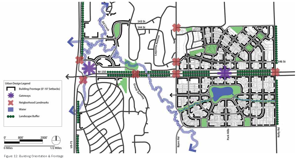
To create a more pedestrian-friendly environment within the study area, the plan proposes that certain sides of development parcels be designated "primary building orientation". These sides should have a 15-foot maximum setback from curb to building face. In addition, the primary orientation should include special façade and fenestration treatments and should be the primary building entry location. The map illustrates how the backage and local streets will become the front door for the businesses and residences that locate within the study area. (Figure 12)
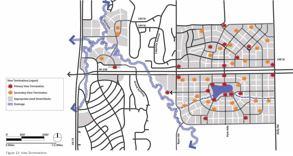
View Terminations
An important element in the creation of place is the visual experience. To this end, it is important to consider view termination - the building, monument, or open space seen when looking down a street. The map below shows the important view termination points and sight lines that must be considered when designing a building or laying out development on a parcel. The view must be considered in the design and will require higher quality architectural and design treatments. At a minimum, view termination points cannot include trash enclosures, service entrances, or truck access. The view terminations are based on sight lines from the road alignment. Additionally, view terminations should focus on gateways and landmarks located within neighborhoods when appropriate. (Figure 13)
Right-of-Way Treatments
The design of spatial elements located along the highway rights-of-way, including retaining walls, landscaping, signage, accent lighting, and any new bridges, will be a prime contributor to the character and identity of the corridor. Artist input should be included in concept development of elements located in the rights-of-way, and the designs should emphasize themes consistent with the vision set forth in this Plan. The intent is to create a visually exciting experience for those traveling along the corridor. Reflections and inspirations can be interpreted and integrated into infrastructure design, and new design should strive to:
•
enhance awareness of place,
•
encourage the integration of infrastructure and landscape, and
•
provide a restorative experience for all users of the corridor - drivers, walkers, bicyclists.
Landmarks & Gateways
Gateways and landmarks help to create a sense of place and assist people in creating their mental maps of places. Gateways are distinct elements that notate the boundaries and access points into districts. Gateways can take the form of monuments, walls, bridges, arches, or distinctive architecture.
Landmarks can be smaller-scaled elements that are located within districts and can become organizing elements for neighborhoods. Landmarks can include monuments, plazas, parks and distinctive architecture.
Sidewalks & Bike Paths
Throughout the study area the plan proposes sidewalks on both sides of streets. Backage streets are proposed to have a minimum sidewalk width of 8-feet on each side. Arterial streets should include sidewalks on each side and a minimum width of 10-feet. The frontage roads along M-150 should have pedestrian pathways no less than 6 feet wide. All sidewalks should have a vegetated buffer between the sidewalk and the roadway.
The plan proposes the creation of bike paths on the backage and main north-south streets. Bike paths on the frontage roads are proposed when needed for connectivity. A grade-separated bike and pedestrian crossing could be located near Park Hills Drive to provide safe connectivity between develops north and south of M-150.
Street Design
Key to establishing character is the interrelationship between urban form and streets. The Character Framework Plans describe the urban design principles for the appropriate design of the proposed urban form. This section addresses the appropriate design of the streets throughout the study area.
Street Components
An objective of this plan is to establish an overall streetscape character framework and hierarchy of streets. For the purposes of analysis, each existing and proposed street can be divided into three zones: the travel zone, pedestrian zone and development zone. Refer to Figure 14 for a depiction of the zones. Design principles for the travel and pedestrian zones are included in the Corridor Character Principles section of the Appendix.
Travel Zone
The travel zone includes the public realm elements located between the curb lines: the vehicular lanes, bicycle lanes, medians, crosswalks and on-street parking. The design of the travel zone affects how much traffic a street can carry and how fast vehicles will travel. As a general rule, as lane width increases vehicles can comfortably travel at higher speeds. Alternatively, as lane width decreases so does the speed travelers are comfortable driving.
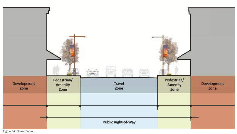
Pedestrian/Amenity Zone
The pedestrian/amenity zone is the section of the street needed to move people between land uses, and between vehicles and land use. This environment includes sidewalks, curb and gutter, bus stops and street furniture such as lighting and benches. Street trees, tree lawns and planter boxes are typically located in a green area which separates the pedestrian walkway from the traffic zone. The pedestrian/amenity zone is the interface between the development zone and the travel zone. A high quality pedestrian environment is essential on streets to encourage street activity and provide for a safe and inviting area.
Development Zone
The development zone is established by the property line and design recommendations are provided through the Design Standards and Guidelines that will be created. It is important that the design of buildings and entrances appropriately interfaces with the design of the pedestrian and amenity zone.
Street Types
The roadway alternatives for the M-150 corridor are made up of four street typologies: frontage streets, arterial streets, backage or reverse access streets, and local streets. Frontage and arterial streets should be designed to distribute traffic to backage and local streets. This section includes a description and graphic for four street types that occur along the corridor. Each of these types possesses differing street zone characteristics.
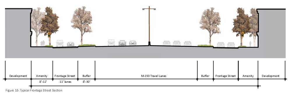
Frontage Streets
Frontage streets provide limited access and run parallel to the highway, and feed traffic to the highway at appropriate points of access such as at arterials. Frontage streets should be designed for one through lane plus turning lanes, and should never exceed three lanes in width. Lane width is encouraged at 11 feet based on anticipated travel speeds and weaving movements that occur on frontage streets.
Planting strips of various widths would be provided between the highway and the frontage streets and between the frontage streets and pedestrian pathways. Access from the frontage streets should be limited to the north-south streets. Access to parcels adjacent to the frontage streets and M-150 will be accomplished through backage or reverse access streets.
Arterial Streets
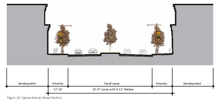
Arterial streets provide high capacity mobility between the backage and local streets to the highway and other arterials connecting throughout Grandview. Byars Road and Park Hills Drive are envisioned as 4-lane arterials, including a landscaped median; two, 10 and half foot travel lanes in each direction; an 8-foot sidewalk on each side; and tree-zones on each side separating the roadway from the sidewalk. (See Figure 16)
General characteristics include:
•
Sidewalks & Street trees
•
Median treatments
•
Pedestrian lighting & aesthetics: banners, planters, etc.
•
Modest setbacks to shield vehicular traffic from adjacent land uses
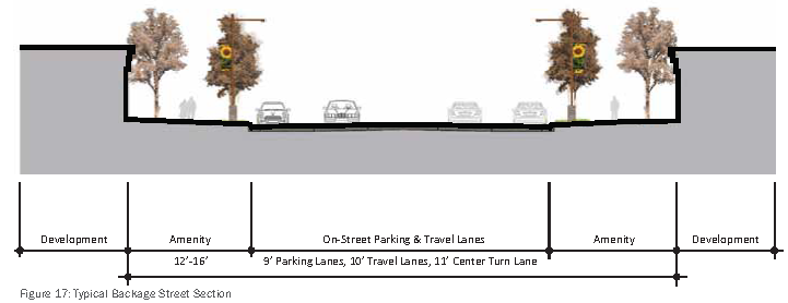
Backage/Reverse Access Streets
Backage streets serve as a parallel facility to the highway, designed to operate at slower speeds; they create opportunities to travel east-west through the corridor without requiring travel on the frontage streets or M-150. The desired outcome is to create a pedestrian-friendly street roughly parallel to M-150. The backage streets should have one 10-foot wide travel lane in each direction and a shared 11-foot wide center turn lane. They should include a 9-foot parking lane on each side; a 6-foot tree-zone, and 8-foot sidewalks. (See Figure 17)
•
Wide sidewalks & street trees
•
On-street parking
•
Bulb outs at arterial intersections
•
Pedestrian lighting & aesthetics: banners, planters, etc.
•
Narrow development setbacks
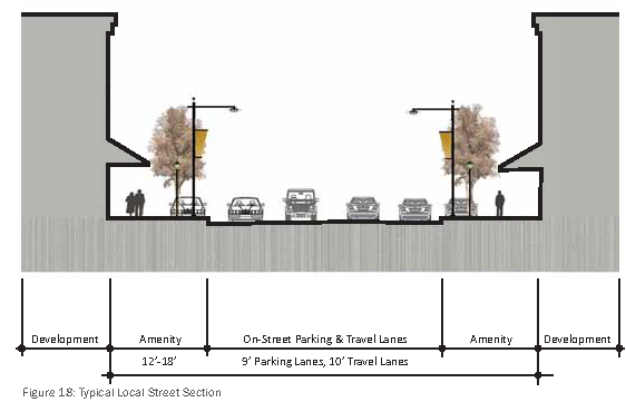
Local Streets
The local street type encompasses both collector and local streets. Both have similar characteristics and function in connecting between uses. Collectors are designed to provide a balance between mobility and land access within residential, commercial and industrial areas. The makeup of a collector street largely depends on the density, size and type of nearby buildings. Local streets typically carry lower traffic volumes and provide access within and between neighborhoods and businesses. Local streets typically vary between two to three 10-foot-wide vehicular lanes total, and have a 12 — 18-foot-wide pedestrian zone to encourage walking (See Figure 18). General characteristics include:
•
Wide sidewalks & street trees
•
Median treatments at focused locations
•
On-street parking
•
Bulb outs at arterial intersections
•
Pedestrian lighting & aesthetics: banners, planters, etc.
•
Minimal development setbacks to define the street edge