Grandview City Zoning Code
31-4
ZONING DISTRICTS AND OVERLAYS
(A)
Names of Zoning Districts.
The City of Grandview is hereby divided into Zoning Districts as follows:
(B)
Establishment of Zones by Official Zoning District Map.
The boundaries of said Zoning Districts are shown upon the map attached hereto and made a part of this Ordinance, said map being designated as the "Official Zoning District Map" and all notations, references, and other information shown thereon are a part of this Ordinance and have the same force and effect as if the zoning district map and all such notations, references, and other information shown thereon were fully set forth or described herein.
(C)
Identification and Location of Official Zoning District Map.
The Official Zoning District Map shall be identified by the signature of the Mayor, attested by the City Clerk together with the date of adoption of this Ordinance. The Official Zoning District Map shall be located in the office of the Community Development Department.
(D)
Changes in Boundaries.
Changes in the boundaries of the districts shall be made by ordinance adopting an amended zoning district map, or part of said map, or units or a part of said zoning district map, which said amended maps, or parts of units of parts, when so adopted, shall become a part of this Ordinance.
(E)
Uncertainty in Boundaries.
Where uncertainty exists with respect to the boundaries of the various districts as shown on the Official Zoning District Map, incorporated herein, the following rules shall apply:
(1)
The district boundaries are the centerlines of streets, alleys, waterways or flood way boundaries, and railroad rights-of-way, unless otherwise indicated; and where the designation of a boundary line on the zoning map coincides with the location of a street, alley, waterway or flood way boundaries, or railroad right-of-way, the centerline of such street, alley, waterway or flood way boundaries, or railroad right-of-way shall be construed to be the boundary line of such district;
(2)
Where the district boundaries do not coincide with the location of streets, alleys, waterways or flood ways hereof, or railroad rights-of-way but do coincide with lot lines, such lot lines shall be construed to be the boundary of such district;
(3)
Where a public street or alley is officially vacated or abandoned, the area comprising such vacated street or alley shall acquire the classification of the property to which it reverts; and
(4)
Where the district boundaries do not coincide with the location of streets, alleys, waterways or flood ways thereof, or railroad rights-of-way or with lot lines, the district boundaries shall be determined by the use of the scale shown on the zoning map.
(F)
Overlay Districts.
The purpose of the overlay district is to create a unique sense of place through thoughtful urban design. Overlay district design criteria may vary depending on the existing environment, either built and/or natural and the goals of each individual overlay. The regulations of the overlay districts are superimposed over the base zoning district.
(1)
Town of Grandview Overlay District.
(a)
Purpose.
The Town of Grandview Overlay District is largely made up of the originally platted subdivisions of Grandview. These subdivisions came into existence near the turn of the 20th century when the community was still in its early stages of growth. Adjacent to the Kansas City Southern Railway, many homes were built on the newly platted land and were designed with traditional building form. Many subdivisions consists of small to large lots with homes of varying sizes. Common features of the homes built during this period are large front porches, detached or no garages, narrow and deep lots, smaller side yard setbacks, etc.
(b)
Development Form.
In terms of infill development, the City of Grandview recognizes that a standard bulk regulation for residential subdivisions is not appropriate citywide and needs to be specified for different areas based on the time period in which they were developed. The Town of Grandview Overlay District is intended to increase land development productivity through modifications to lot area and setback requirements, prioritize traditional building form over modern design, and allow Accessory Dwelling Units (ADU). Additionally, the following minimum design standards apply to the district:
(i)
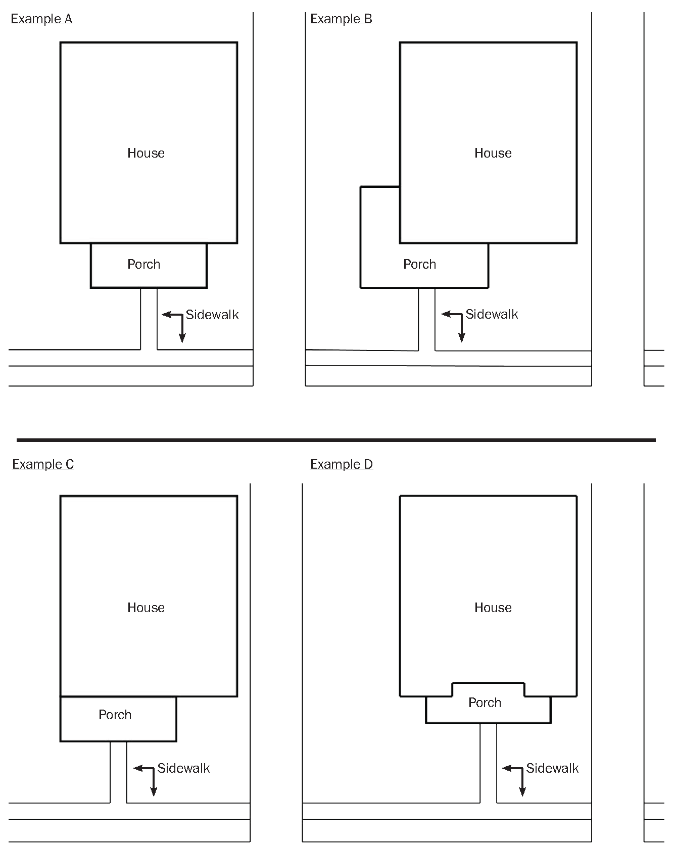
Entrances.
A home's entrance shall be the dominating architectural feature. Entrances are diverse and engaging by providing porches in various arrangements. Porches create a social gathering space for residents, encourages neighborliness, and creates visual awareness on the street. Sidewalks shall directly connect the entrance of the home to a public sidewalk. Secondary sidewalks may connect to driveways. Porches may encroach into the required front/side yard setback up to 1/3 of the setback distance.
(ii)
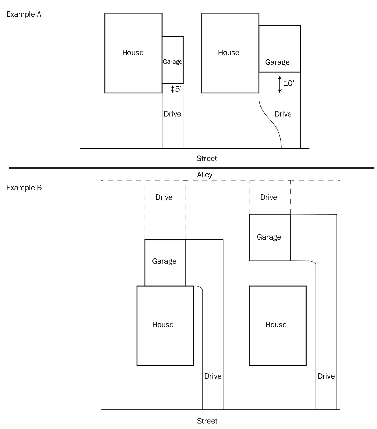
Garages.
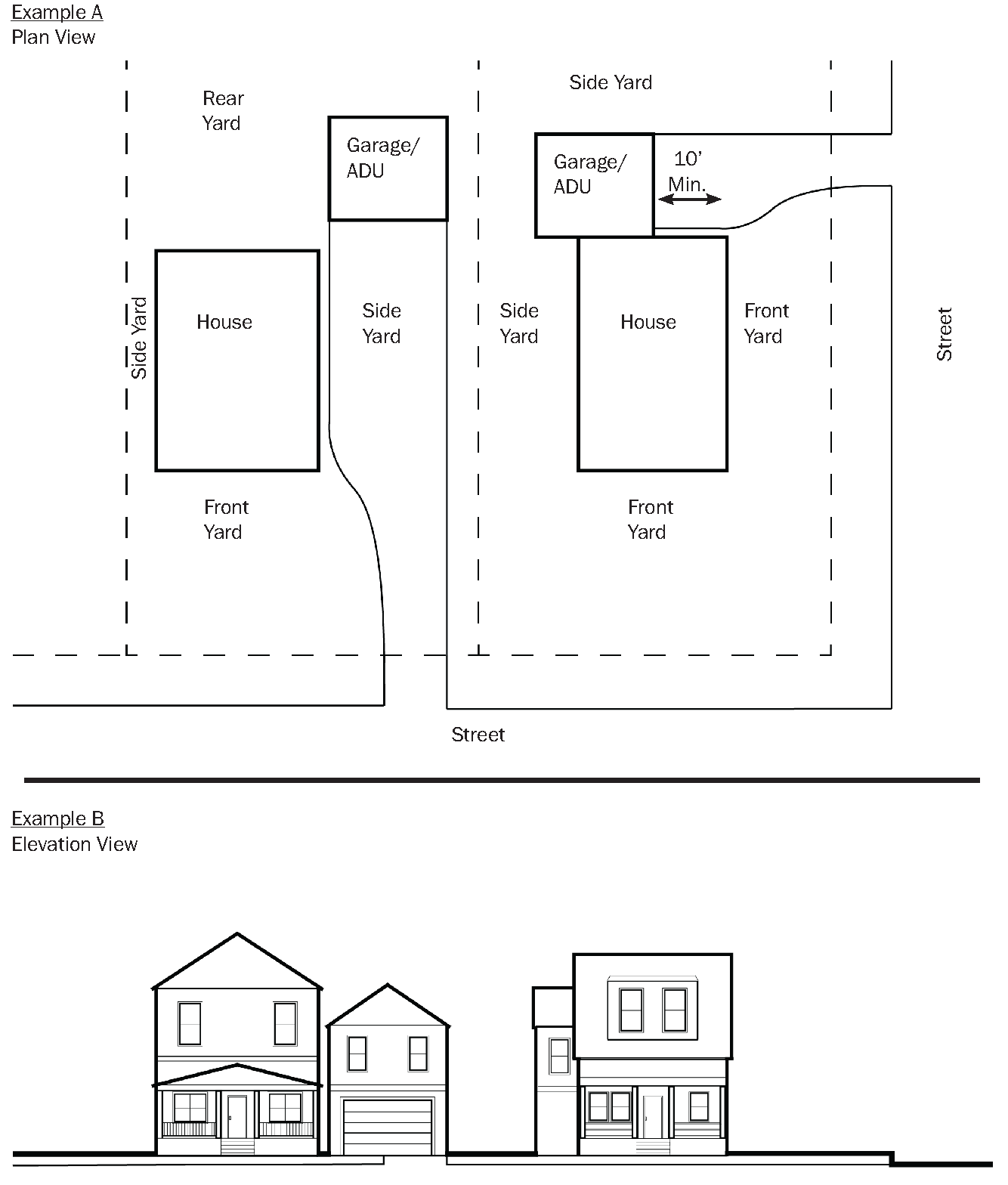
Garages shall be understated and not seen as the dominating feature of the home. In this overlay district, garages that are attached and on the front face of the home, shall be setback 5' for each parking bay it contains. Rear loaded or detached garages that sit in the rear yard are preferred and may be accessed by a driveway or alley.
(iii)
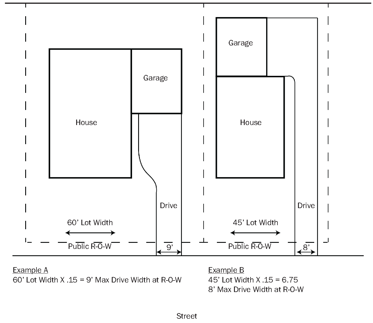
Driveways
Driveways, like garages, shall be understated. Residential driveways shall be a minimum of 8' wide, but no wider that 15% of the total lot width within the right-of-way. Residential driveways may expand up to three lanes wide, but such expansion may only occur on private property. Driveways shall connect to alleys when present to preserve the public realm.
(iv)
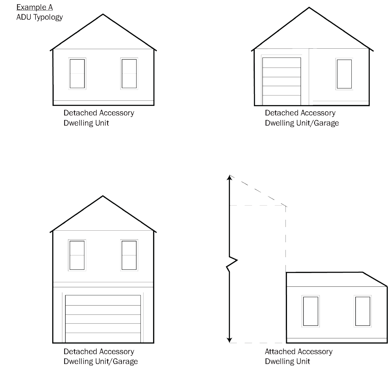
Accessory Dwelling Unit (ADU)
Accessory Dwelling Units are an easy way to achieve many goals for a community and property owners. An ADU is not a foreign concept for adding housing units to existing neighborhoods. While the terminology has changed over time, ADUs have been a part of American cities for hundreds of years. This housing strategy aims to create additional affordable dwelling units, increase property values and return on investment for the City, and provide supplemental income for property owners. Accessory Dwelling Units build on the traditional development form that much of the Town of Grandview Overlay District is made of.
ADUs may be located in a rear yard of an interior lot or the side yard of a corner lot, as long as the unit is at least 10' behind the front face of the principal structure. An ADU shall not be larger than 60% of the square foot of the principal structure (dwelling) or 720 square feet, whichever is more restrictive or be taller in height. The accessory unit may be built atop or next to garages, either attached or detached from the principal structure, garage to dwelling conversions, or as a stand-alone accessory structure. No matter the arrangement, applicable adopted building code shall be met. Only one (1) ADU is allowed as an accessory use in the Overlay District for R-1, Single-Family zoned property. An additional off-street parking space is required, if before the ADU is in existence, the parking minimum for the principal structure is present. ADUs shall meet the definition as outlined in 31-3 of this Ordinance.
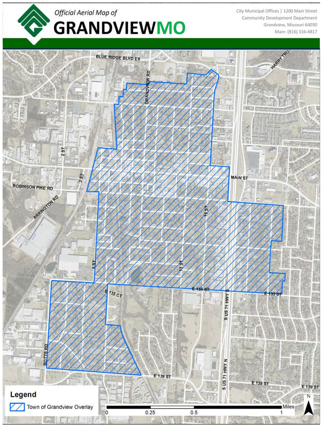
(c)
Town of Grandview Overlay District Area.
The Town of Grandview Overlay District is an irregular shape, but can be generally described as much of the residentially zoned areas west of I-49, north of 139th Street, east of the Kansas City Southern Railroad, and south of Harry Truman Road or simply, much of the originally platted subdivisions of Grandview.