Wendell City Zoning Code
CHAPTER 16
DEVELOPMENT PLAN REQUIREMENTS
16.1 - Purpose and Intent
This Chapter describes the information required for all development activity to ensure compliance with the standards found in this Ordinance. The submission of a complete application in accordance with this Chapter is necessary prior to the scheduling of any review by the Administrator, Technical Review Committee, Planning Board, and/or Board of Commissioners.
16.2 - Reserved
Editor's note— Ord. No. O-07-2022, § 1, adopted Feb. 14, 2022, repealed UDO § 16.2, which pertained to number of plan sets required and derived from Ord. No. O-8-2010, adopted July 26, 2010.
16.3 - Environmental Survey
An environmental survey is intended to identify forest stands or trees of a uniform size and species; specimen trees of varying sizes and species, particularly free standing or open-grown or field grown trees; a distinctive tree line or forest edge; existing watercourses; and previously documented endangered species habitats. Identification of existing trees, understory vegetation, known endangered species, habitats, wetlands, perennial streams, floodplains, and topographical features on a site prior to the advanced preparation of development plans enables the reasonable and practical planned preservation of existing and environmentally sensitive areas. This requirement provides the Town and the applicant the ability to evaluate the proposed development in order to preserve vegetation, to improve the appearance of the development proposed and to encourage the use of the existing forest and tree canopy, specimen trees, and significant vegetation to satisfy the requirements of this Ordinance.
A.
For Master Plan/Preliminary Plan submittals, the use of digital geographic data (including, but not limited to, aerial photography, topography, wetland information, tree cover or other information that may be available and relevant) obtained from the Town of Wendell or Wake County is deemed to be sufficient.
B.
For Construction Documents, the Environmental Survey requirements are as follows (Note: This requirement can be waived by the Administrator if he/she determines the site lacks qualifying natural features.):
1.
Provide a general written description of the significant vegetation, including the typical tree species composition of the forest stand, typical tree size, and general health and vigor of the stand and specimen trees. Significant vegetation is defined as canopy trees 12 inches in diameter at breast height (DBH) or greater and native understory species 2 inches in diameter or greater (e.g. dogwood, holly, redbud, etc.).
2.
Denote the dripline of any existing forest stand.
3.
Identify all open grown or specimen trees located on the site 12 inches or greater DBH.
4.
Denote site conditions as "prime buildable," "secondary buildable," "conserved," or "preserved" as defined in Section 8.5, Tree Protection.
5.
Show all other important natural features influencing site design such as the location of wetlands, rock outcroppings, site topography at two-foot contour intervals, slopes steeper than 15 percent, and perennial streams, natural drainage ways, lakes, and other water bodies, and floodplains indicating both the flood fringe and the flood way. USGS and FEMA data shall be used to determine the location of perennial streams.
6.
Denote the presence of any known endangered species' habitats indicated in any surveys completed by Wake County, the State of North Carolina, or other governmental agency.
7.
Show all buffer delineations as follows:
a.
Stream buffer boundaries including all undisturbed buffer zones shall be clearly delineated on all Development Plans for approval by the Town, on all Construction Documents, including grading and clearing plans, erosion and sediment control plans, and site plans.
b.
Buffer boundaries for all required undisturbed buffer zones shall be clearly delineated on-site prior to any land disturbing activities. Where existing trees are to be preserved in a buffer zone, limits of grading shall maintain a minimum 20-foot separation from the base of each tree on the upland side of the buffer or to the dripline.
c.
Buffer boundaries including all buffer zones as well as all buffer requirements shall be specified on the record plat, on individual deeds, and in property association documents for lands held in common.
16.4 - Sketch Plan Requirements
The Sketch Plan shall show in simple sketch form the proposed layout of streets, lots, buildings, public open spaces and other features in relation to existing conditions based upon the size of the tract proposed for development. Sketch Plans shall be reviewed as binding documents for Zoning Permits, but shall be used for non-binding review for all other development application processes in which a Sketch Plan is required. All plans shall be submitted at a scale not less than one inch = 50 feet (for Site Plans) or one inch = 200 feet (for Subdivisions) unless otherwise authorized by the Administrator.
Sketch Plans shall include the following information:
A.
The name of the proposed development.
B.
Name of map or plan (e.g. Sketch Plan)
C.
The name, address and telephone number of the property owner.
D.
The name, address and telephone number of the developer, if different from property owner.
E.
A sketch vicinity map, including north arrow and property address, showing the location of the subdivision in relation to neighboring tracts, subdivisions, roads, and waterways.
F.
Date(s) map(s) prepared or revised.
G.
Name, address and telephone number of map preparer.
H.
North arrow and orientation (north arrow shall be oriented toward the top of the map where practical)
I.
Scale denoted as a bar graph and numerically.
J.
The existing boundary lines of the property and total acreage. If existing property lines are to be changed, label as "old property lines" and show as dashed lines.
K.
Lots of adjacent developed or platted properties, including tax map, block, and parcel numbers
L.
The existing and proposed land uses and the existing land uses of adjacent properties.
M.
Zoning classification of the land and adjacent properties.
N.
Corporate limits, town limits and other jurisdiction boundary lines on or within 300 feet of the land to be subdivided or developed, if any.
O.
The location, names and right-of-way width of any existing streets on and within 300 feet of the land to be subdivided or developed.
P.
Location of existing or proposed thoroughfares or collector streets on and within 300 feet of the property as shown on the Town's currently adopted Arterial and Collector Street Plan.
Q.
Floodplain and floodway delineation.
R.
Water courses, ponds, lakes or streams.
S.
Railroad lines and rights-of-way.
T.
Location of existing public water and/or sewer lines on and within 300 feet of the property.
U.
Dimensions, location, and use of all existing buildings; distances between buildings measured at the closest point; distances from buildings to closest property lines; and, buildings to remain on final plan.
V.
Name and location of any property or building on the National Register of Historic Places or locally designated historic property.
W.
If deemed necessary by the Administrator, existing topographic conditions shall be provided. Contours should be at least in two-foot intervals. Wake County or Town of Wendell topographic information may be used to fulfill this requirement.
X.
Proposed lot lines, dimensions and street network.
Y.
Square footage of all lots less than one acre in size, with smallest lot indicated. Acreage for all lots over one acre.
Z.
Site calculations, including acreage in total tract, total number of lots proposed.
AA.
Lots sequenced or numbered consecutively.
BB.
Street data illustrating right-of-way lines
CC.
Plan for providing water and sewer service in graphic or narrative form.
DD.
General open space areas.
EE.
Statement of Comprehensive Plan consistency.
(Ord. No. O-20-2016, § 5, 11-14-2016)
16.5 - Master Plan/Preliminary Plan Requirements
The Master Plan (or Preliminary Plan for Major Subdivisions) shall be drawn to the following specifications and shall contain or be accompanied by the information listed below. All plans shall be submitted at a scale not less than one inch = 50 feet (for Site Plans) or one inch = 200 feet (for Subdivisions) unless otherwise authorized by the Administrator. No processing or review of a Master Plan or Preliminary Plan will proceed without all of the information required for Sketch Plan review in addition to the information listed below:
A.
Plat book or deed book references.
B.
Names of adjoining property owners (or subdivision or developments of record) with plat book and/or deed book reference.
C.
The boundary, as determined by survey, of the area to be developed with:
1.
All bearings, curve data and distances on outside boundaries and street centerlines;
2.
Street centerlines tied to the boundary;
3.
The location within the area, or contiguous to it, of any existing streets, railroad lines, perennial streams, wetlands, easements or other significant features of the tract.
4.
At least one corner tied to the NC grid with grid coordinates provided where at least one of two control monuments needed are within 2,000 feet of the boundary. Otherwise, boundary should be tied to the nearest street intersections.
5.
Locations of intersecting property boundary lines of adjoining properties.
D.
Site calculations including total acreage of tract, acreage in recreational open space and other non-residential uses, total number and acreage of parcels, and the total number of housing units.
E.
Original contours at intervals of not greater than two feet for the entire area to be subdivided/developed and extending into adjoining property for a distance of 100 feet at all points where street rights-of-way connect to the adjoining property and ten feet at all other points of common project boundaries. At least two contours per map should be labeled. Wake County or Town of Wendell digital topography may be used to satisfy this requirement but should be field-verified by the applicant's consultant to ensure accuracy. This requirement may be waived by the Administrator for developments smaller than one acre or where insufficient topographic changes warrant such information.
F.
Building elevations required for all Major Site Plans.
G.
The location of:
1.
Proposed buildings
2.
Parking and loading areas
3.
Streets and alleys with total right-of-way dimensions; right-of-way width dimensions from center lines of existing public streets; and existing and proposed street names
4.
Lots
5.
Detailed plans of parks, recreation and open space
6.
Site reservations (e.g., school sites)
7.
Property lines and building setback lines
8.
Tentative lot dimensions
9.
Building restriction areas (i.e., flood hazard areas, buffer locations, watershed protection districts, and/or jurisdictional wetlands)
10.
Location, dimension, and type of all easements (existing and proposed)
11.
Proposed size of utility mains, extensions and services
H.
Environmental Survey Requirements in accordance with Section 16.3.
I.
Calculations of proposed impervious cover.
J.
Typical cross-sections of proposed streets and alleys. Cross-sections shall include the following information: right-of-way widths, pavement widths, curb and gutter profile, planting strip widths and locations, sidewalk widths and locations, underground utilities' widths and locations, and building setbacks.
K.
The proposed limits of construction for all proposed development activity.
L.
Illustrative Landscape/Tree Plan showing general location and massing of proposed landscape material.
M.
Phase lines (if applicable).
N.
Certification statements.
O.
Floodplain Development Permit and Certification application with supporting documentation as required by the Wendell Flood Damage Prevention Ordinance (if applicable; see Chapter 6). (Application must be prepared for review, although not necessarily approved at the time of submittal of the Master Plan/Preliminary Plan documents.)
P.
Certificate of Appropriateness for historic properties (if applicable).
Q.
Traffic Impact Analysis (if applicable; see Section 16.11, Traffic Impact Analysis).
*Submittal of estimated payment-in-lieu of dedicated open space must be made at the time of master plan/preliminary plat approval (if applicable).
16.6 - Construction Document Requirements
The Construction Documents for Site Plans and Subdivision Plans shall be submitted in accordance with the specifications of this Section except where specifically noted. Construction Documents shall constitute the final submittal requirements for Site Plans and Major Subdivision Plans required prior to construction.
Construction Drawings shall be drawn to the following specifications and shall contain or be accompanied by the applicable information listed below. All plans shall be submitted at a scale not less than one inch = 50 feet unless otherwise authorized by the Administrator. All streets, utilities, and stormwater, and other infrastructure systems shall be designed and constructed in accordance with the adopted Standard Specifications and Details of the Town of Wendell, and/or other authorized entities (i.e. CORPUD, NCDOT). No processing or review of Construction Documents will proceed without all of the information required for Sketch Plan and Master Plan review in addition to the following information:
A.
The proposed names of the development and streets, the owner's name and address, signature of the owner or owner's duly authorized agent, the surveyor's and/or engineer's name, signature, and seal.
B.
Site calculations including total acreage of tract, acreage in parks and other non-residential uses, total number and acreage of parcels, the total number of housing units, area of all mixed-use and non-residential buildings, gross project density per acre, linear feet of streets, and the accurate locations and descriptions of all monuments, markers, and control points.
C.
Existing topography and finish grading with contours drawn at two-foot intervals. This requirement may be waived for developments smaller than one acre or where insufficient topographic changes warrant such information.
D.
Proposed lot lines, lot and block numbers, and exact dimensions.
E.
The future ownership (dedication or reservation for public use to a governmental body; for owners to duly constituted home owners' association; for tenant's remaining in subdivider's ownership of recreational open space lands).
F.
The location of proposed buildings, parking and loading areas, streets, alleys, lots, reservations (i.e. school sites), property lines and building setback lines with street dimensions, lot dimensions, and the location of any building restriction areas (i.e. flood hazard areas, watershed protection districts, and/or jurisdictional wetlands).
G.
The location and dimensions of all off-street parking and loading spaces, and walkways indicating the type of surfacing, size, angle of stalls, and width of aisles.
H.
The location and dimensions of proposed open space, and required amenities and improvements including the calculated area of all required open space dedications in accordance with Chapter 7.
I.
The location and dimensions of any sidewalks, curb and gutters to be installed along public street frontages, and other required street improvements designated in Chapter 9 of this Ordinance. Required right-of-way shall be drawn in the location shown on any official plan at the width specified in this Ordinance.
J.
Typical cross sections of proposed streets showing rights-of-way, pavement widths, grades, and design engineering data for all corners and curves. Where a proposed street is an extension of an existing street the profile of the street shall include 300 feet of the existing roadway, with a cross section of the existing street. Where a proposed street within the subdivision abuts a tract of land that adjoins the subdivision and where said street may be expected to extend into said adjoining tract of land, the profile shall be extended to include 300 feet of the said adjoining tract.
K.
The location of any existing or proposed demolition landfills in the site. Such sites shall not be used for building.
L.
The plans for utility layouts, including sanitary sewers, storm drains, and water lines, illustrating connections to existing systems.
M.
Utility Layout Plan showing connections to existing systems, line sizes, material of lines, location of fire hydrants, blow offs, valves, manholes, catch basins, force mains, etc. for the following types of utility lines: sanitary sewer; water distribution; storm sewer.
N.
The location and size of all utility lines, easements, and rights-of-way. Easements shall be provided on all Construction Documents as follows:
1.
Utility Easements. Easements for underground or above ground utilities shall be provided for and centered along rear or side lot lines, and shall be a minimum of ten feet in width. Easements for water and sanitary sewer lines shall be centered on the pipe and a minimum of 20 feet in width or as required by the City of Raleigh Public Utilities Department (CORPUD) Handbook. City of Raleigh utility easements shall not be shared with any other utilities, storm drainage pipes or BMPs.
2.
Drainage Easements. Where a development is crossed by a stream or drainage way, an easement shall be provided conforming to the lines of such drainage way and in accordance with the adopted Standard Specifications and Details of the Town of Wendell.
3.
Landscape Easements. Landscape easements (if necessary or required) for street yards, planting yards and along any private streets should be designed in accordance with the provisions of Chapter 8, Tree Protection and Landscaping. The Town may require landscape easements for planting yards for developments where industrial or commercial uses abut residential uses.
4.
Public Access Easements. Public Access Easements shall be provided for sidewalks, trails, greenways, and other pedestrian and bicycle facilities that provide connections other than within public rights-of-way.
5.
Maintenance of Easements: Note indicating that "maintenance of easements shall be the responsibility of the property owner" shall be included on the Construction Documents.
O.
Non-Public/Private Water and Sewer Utilities: Well and septic systems which do not come under the immediate supervision of the municipality shall comply with the following:
1.
Individual sewer and water system. An acknowledgment from the Wake County Health Department indicating that the water supply and sewage disposal system installed or proposed for installation fully meets the requirements of the North Carolina State Board of Health.
P.
A copy of the soil erosion and sedimentation plans and approval letter.
Q.
Approved Floodplain Development Permit and Certification application with supporting documentation as required by the Wendell Flood Damage Prevention Ordinance (if applicable).
R.
Stormwater permit (if applicable).
S.
Supplemental Plans, as applicable:
1.
Landscape Plan in accordance with Section 16.8.
2.
Lighting Plan in accordance with Section 16.9.
3.
Architectural Plans in accordance with Section 16.10.
T.
Required notes and certifications (see Section 16.14)
16.7 - Final Plat Requirements
The final plat shall be prepared by a registered land surveyor, licensed to practice in the State of North Carolina and shall be drawn to a scale no less than one inch = 100 feet, and shall meet the requirements of the Wake County Register of Deeds Office. The final plat shall constitute an entire phase as shown on the approved master plan. The size and number of completed applications shall be set by the Technical Review Committee.
No Final Plat shall be approved unless and until as-built drawings have been submitted to and approved by the Town of Wendell and CORPUD and the subdivider has installed in the platted area all improvements required by this Ordinance or has posted Improvement Guarantees, as described in Chapter 17. The Final Plat shall contain the following:
A.
A vicinity map showing the location of the subdivision with respect to adjacent streets and properties.
B.
The name of the owner, and the name, signature, registration number, and seal of the registered surveyor under whose supervision the plat was prepared.
C.
The name of the subdivision.
D.
The date of the plat.
E.
The exact boundary of the tract of land being subdivided showing clearly the disposition of all portions of the tract.
F.
Scale denoted both graphically and numerically with north arrow and declination.
G.
Sufficient data, as determined by the Administrator, to determine readily and reproduce accurately on the ground the location, bearing, and length of every street, alley line, lot line, building line, easement line, and setback line. All dimensions, bearings, and angles shall be in accordance with the Standards of Practice for Surveying in the State of North Carolina.
H.
The lines and names of all streets, alley lines, lot lines, lot and block numbers, lot addresses, building setback lines, easements, reservations, on-site demolition landfills and areas dedicated to public purpose with notes stating their purposes.
I.
All plats showing a regulated floodplain shall be noted with the following statement:
"Any construction or use within the Special Flood Hazard Area (SFHA) is subject to the restrictions imposed by the Wendell Flood Damage Prevention Ordinance."
A minimum finished floor elevation shall be noted for all lots in the SFHA as well as referenced FIRM map and date of map.
J.
The accurate locations and descriptions of all monuments, markers, and control points.
K.
Underground and aerial utility easements shall be shown.
L.
The exact location of stream corridor buffer boundaries including all buffer zones as well as all buffer requirements shall be specified on the record plat, on individual deeds, and in property association documents for lands held in common.
M.
As-built drawings and plans of all water, sewer, and storm drainage system facilities, illustrating their layouts and connections to existing systems. Such plans shall show all easements and rights-of-way, to demonstrate that the facilities are properly placed and the locations of all fire hydrants, blow-off valves, manholes, pumps, force mains, and gate valves are indicated. This information shall not be placed on the final plat but shall be submitted at the time of request for final plat approval.
* Submittal of all outstanding fees is required before Final Plat approval.
16.8 - Landscape Plan Requirements
A.
A landscape plan shall be required prior to any land disturbance for any proposed development plan. (Predevelopment site grading, or any land disturbing activity of one acre or more that is not regulated by a site plan previously approved by the Board of Commissioners, shall be governed by the provisions of Section 8.4, Landscape Plans.)
B.
The plan shall contain the following information:
1.
Name of the project, name and address of owner, name and address of designer, scale, date, legend, and north arrow.
2.
An accurate, scaled drawing of property boundaries with zoning designations of proposed development and adjacent properties drawn to a scale no less than one inch = 50 feet (for Site Plans) or one inch = 200 feet (for Subdivisions) unless otherwise authorized by the Administrator.
3.
A development summary including the total development acreage, proposed use(s), required parking and provided parking spaces, and total building square footage.
4.
The location of proposed buildings, signage, driveways, parking areas, required parking spaces, connections to existing streets, and traffic patterns.
5.
The location of all overhead and underground utilities.
6.
General location, type and quantity of existing plant materials.
7.
Existing plant materials and areas to be left in natural state.
8.
Methods and details for protecting the critical root zone (CRZ) of existing plant materials during construction.
9.
Locations, size and labels for all proposed plants.
10.
Plant lists with common name, botanical name, quantity, and spacing and size at time of planting of all proposed landscape material.
11.
Location and description of other landscape improvements, such as earth berms, walls, fences, screens, sculptures, fountains, lights, courtyards, walks or paved areas.
12.
Location and type of irrigation system, if applicable.
13.
Planting and installation details as necessary to ensure conformance with all required standards as referenced in Chapter 8.
C.
Alternative Plans: Alternate landscaping plans, plant materials, or planting methods may be used where the Administrator determines that unreasonable or impractical situations would result from application of landscaping requirements, or where necessary to protect existing vegetation. Such situations may result from streams, natural rock formations, topography, or other physical conditions; or from lot configuration, utility easements, unified development design, or unusual site conditions.
16.9 - Lighting Plan Requirements
The applicant for any permit required for work involving exterior lighting shall submit documentation at time of site plan or plot plan approval that the proposed lighting plan complies with the provisions of Chapter 11, Lighting. The submission shall contain, but not be limited to the following, all or part of which may be part of or in addition to the information required in Chapter 11:
A.
A site plan drawn to scale showing building(s), landscaping, parking areas, and proposed exterior lighting fixtures.
B.
A point-by-point foot-candle array in a printout format indicating the location and aiming of illuminating devices. The printout shall indicate compliance with the maximum maintained foot-candles required by Chapter 11.
C.
Description of the illuminating devices, fixtures, lamps, supports, reflectors, poles, raised foundations and other devices (including but not limited to manufacturer's or electric utility catalog specification sheets and/or drawings, and photometric report indicating fixture classification [cutoff fixture, wall pack, flood light, etc.]) and the height of fixtures. The Administrator may waive any or all of the above permit requirements, provided the applicant can otherwise demonstrate compliance with Chapter 11.
D.
Measurements: Light level measurements shall be made at the property line of the property generating the light. If measurement on private property is not possible or practical, light level measurements may be made at the boundary of the public street right-of-way that adjoins the property of the complainant or at any other location on the property of the complainant. Measurements shall be made at finished grade (ground level), with the light-registering portion of the meter held parallel to the ground pointing up. The meter shall have cosine and color correction and have an accuracy tolerance of no greater than plus or minus five percent. Measurements shall be taken with a light meter that has been calibrated within two years. Light levels are specified, calculated and measured in foot-candles. All foot-candle values are maintained foot-candles.
16.10 - Architectural Plans
A.
Architectural plans shall be required for Zoning Permit approval in order to determine compliance with the building design requirements in the Ordinance.
B.
Architectural plans shall depict architectural details of proposed buildings and shall consist of:
1.
All exterior wall elevations.
2.
Photos of existing conditions and surrounding structures and properties.
3.
Building Materials Schedule (material samples may be required).
16.11 - Traffic Impact Analysis (TIA)
A.
Transportation Impact Analyses shall be required for a rezoning, subdivision plan, site plan, Special Use Permit, certificate of zoning compliance, or Preliminary Plan for developments with an estimated trip generation of 100 peak hour trips per day or greater as defined in Section 9.10 (or as required by NCDOT, in which case NCDOT TIA regulations should also be followed). Furthermore, at the discretion of the Planning Director, a TIA may be required for projects generating 75 or more peak hour trips, based on case specific determining factors.
1.
Rezoning Transportation Impact Analysis Report: Evaluates whether adequate transportation capacity exists or will be available within a reasonable time period to safely and conveniently accommodate proposed uses permitted under the requested land use or zoning classification.
2.
Transportation Impact Analysis Report: Required for certain permitted and special uses, subdivisions, and Preliminary Plans exceeding the specific trip generation threshold.
B.
The applicant shall provide the full rationale, from a North Carolina licensed engineer, to perform such duties to support the recommendations of this analysis. The submission shall include all pertinent traffic data and computations affecting the design proposal.
C.
The Rezoning Transportation Impact Analysis or the Transportation Impact Analysis Report shall contain the following:
1.
Site Description: A detailed report, containing illustrations and narrative, shall describe the site's characteristics, adjacent land uses, as well as any anticipated development within the site's vicinity influencing future traffic conditions.
a.
A rezoning transportation impact analysis shall provide a description of the development's potential uses.
b.
A transportation impact analysis report shall include access plans, staging plans, and land use/intensity information.
2.
Study Area: The report shall indicate the geographic location of the study area, roadway segments, critical intersections, and access points to be analyzed. The study area shall extend not less than one-half mile from the site.
3.
Existing Conditions: An analysis of the existing transportation conditions, including all data used for the analysis shall be provided in the report, including:
a.
Traffic count and turning movement information, including the date and source from which this information was obtained;
b.
Correction factors used to convert collected traffic data into representative average daily traffic volumes;
c.
Roadway characteristics, including:
i.
Design configuration of existing or proposed roadways;
ii.
Existing traffic control measures;
iii.
Existing driveways and turning movement conflicts in the vicinity of the site.
d.
Existing Level of Service (LOS) for roadways and intersections without project development traffic. LOS shall be calculated for the weekday peak hour, and in the case of uses generating high levels of weekend traffic, the Saturday peak hour.
4.
Horizon Year(s) and Background Traffic: The report shall identify the horizon year(s) that were analyzed in the study, the background traffic growth factors for each horizon year, and the method and assumptions used to develop the background traffic growth. Unless otherwise approved by the Administrator, development impacts shall be examined for the first and tenth years after the development is completed.
5.
Trip Generation, Trip Reduction, and Trip Distribution: A summary of projected a.m. and p.m. peak hour and average daily trip generation for the proposed development shall be provided in addition to projected trip distribution to and from the site. The factors used to determine trip generation, reduction, and distribution are also to be included in the summary.
6.
Traffic Assignment: The report shall identify the projected roadway segment, intersection or driveway traffic volumes, with and without the proposed development, for the horizon year(s) of the analysis.
7.
Impact Analysis: The report shall address the impact of projected horizon year(s) traffic volumes. It shall identify the methodology used to evaluate the impact. The weekday peak hour impact shall be evaluated as well as the Saturday peak hour for those uses exhibiting high levels of weekend traffic generation.
8.
Mitigation/Alternatives: The report shall identify alternatives for achieving traffic service standards, including:
a.
Additional rights-of-way necessary to implement mitigation strategies.
b.
Suggested phasing improvements necessary to maintain compliance with traffic service standards.
c.
Other alternatives, including transportation management strategies.
d.
Anticipated costs of recommended improvements.
(Ord. No. O-17-2019, § 4, 8-12-2019)
16.12 - Floodplain Development Permit Requirements
In addition to the Environmental Survey, floodplain development plans shall be required when applying for a Floodplain Development Permit. All plans shall be submitted at a scale not less than one inch = 50 feet unless otherwise authorized by the Administrator. Application for a Floodplain Development Permit shall be made to the Administrator on forms furnished by him or her prior to any development activities proposed to be located within flood prone areas. Floodplain Development Permits shall be in accordance with the requirements of Section 6.7, Flood Damage Protection Ordinance.
16.13 - Stormwater Permit Requirements
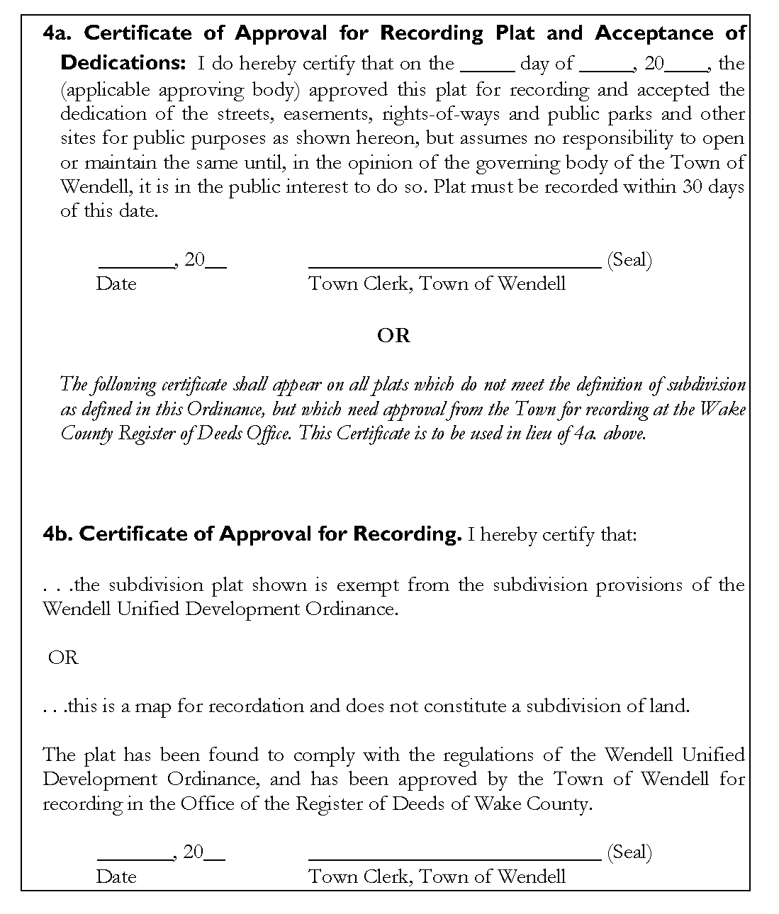
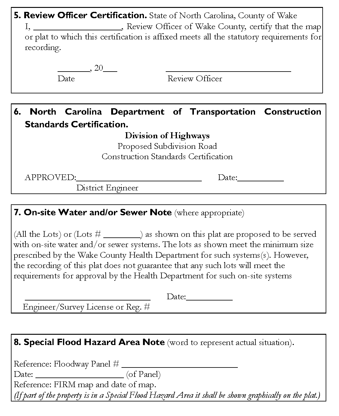
16.14 - Required Notes and Certifications
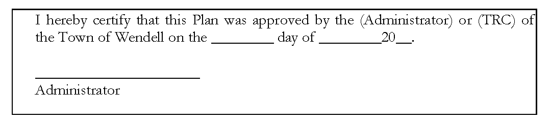
A.
Master Plan/Preliminary Plan Certifications: The following note must appear on the Master Plan/Preliminary Plans:
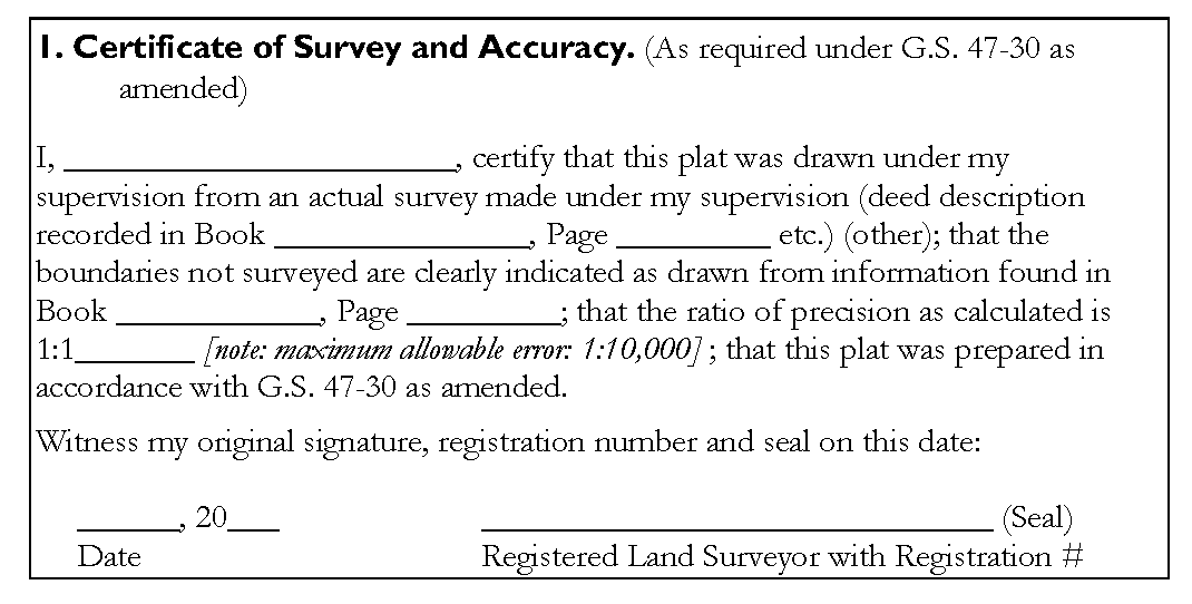
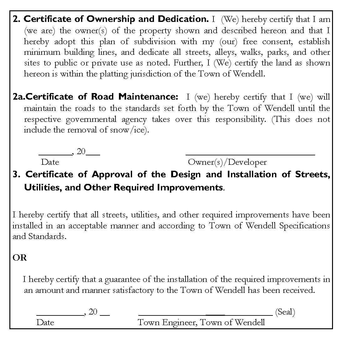
B.
Final Plat Certifications: The following certifications must appear on the Final Plat, as appropriate:
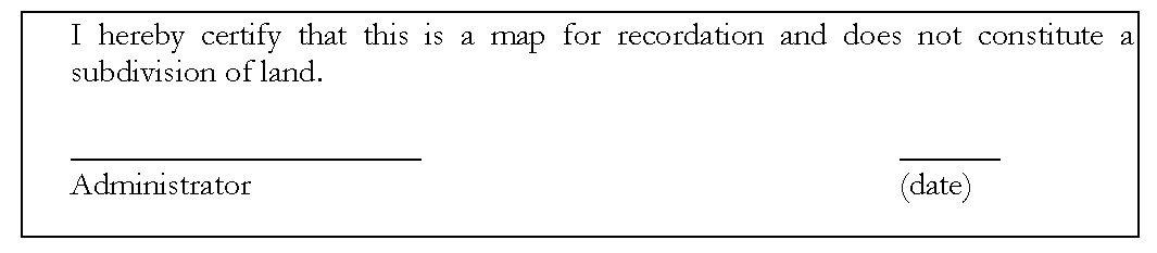
16.15 - Record Plat Requirement
The following certification shall be affixed to the map for recordation in such a manner as to insure that said certificate will be legible on any prints made therefrom: