
Wendell City Zoning Code
CHAPTER 6
ENVIRONMENTAL PROTECTION
6.1 - Purpose and Intent
A primary and fundamental element of this Ordinance is the protection of our existing environmental resources including floodplains and other stream corridors, wetlands, watersheds and groundwater recharge areas, soils, forest stands, specimen trees and other significant vegetation and wildlife. These elements are of economic value to the Town and make it a desirable place to live and visit.
6.2 - Land Suitability
Land subject to flood hazard, improper drainage, erosion or that is for topographical or other reasons unsuitable for development as determined by the Town of Wendell, shall not be platted or developed for residential use nor for any other uses that will continue or increase the danger to health, safety, or property unless the hazards can be and are corrected.
A.
Demolition Landfill Development: Areas that have been used for the disposal of solid waste shall not be subdivided into commercial or residential building sites. This includes areas that have been used for the disposal of trash, demolition waste, construction debris, stumps, and other waste materials.
6.3 - Neuse River Basin Riparian Buffers (NRBs)
A.
Both the corporate limits and the Extra Territorial Jurisdiction (ETJ) of the Town of Wendell fall completely within the Neuse River basin and are therefore subject to the riparian buffer rules as governed by North Carolina Administrative Code (NCAC), Title 15A, Chapter 2, Sub-Chapter B as amended.
B.
NRBs are a form of open space, and as such, may only be retained in private ownership if the necessary conservation easements are recorded with the Wake County Register of Deeds. Otherwise, NRBs shall be separately deeded to a homeowner's association, a non-profit land trust or conservancy, Wake County, or the Town of Wendell (upon approval by the Town Council).
(Ord. No. O-06-2024, § 1, 4-22-2024)
6.4 - Sedimentation and Erosion Control
In order to prevent soil erosion and sedimentation pollution, the developer shall comply with all requirements of the North Carolina Sedimentation Pollution Control Act of 1973, as amended. A Sedimentation and Erosion Control Plan approved by Wake County Environmental Services (or other agencies having jurisdiction) shall be in place prior to any land disturbing activity.
A.
General Requirements. All new development and redevelopment shall be required to take measures to minimize erosion during construction and after development. All new development and redevelopment shall comply with the provisions of the latest adopted amendment to Town of Wendell Environmental Protection Ordinance. A land disturbance permit or exemption shall be obtained from Wake County prior to issuance of a construction improvement permit (CIP) for a subdivision, or part thereof.
B.
Residential Clearing and Grading. In order to promote land development practices that minimize disturbance to vegetation and soils, limit alteration of the natural topography, minimize surface water and ground water runoff and diversion, minimize the need for additional storm drainage facilities, reduce sedimentation in surrounding waters and promote land development and site planning practices that are responsive to the town's scenic character without preventing the reasonable development of land; the initial clearing and grading of all residential major subdivisions shall be limited to dedicated public rights-of-way and easements for the installation of streets, utilities, and other infrastructure. All grading activities shall be done in accordance with all applicable federal, state and local laws, rules and regulations; including those pertaining to air and water pollution and noise control.
1.
Infrastructure. Grading for infrastructure improvements (streets, sidewalks, curb, gutter, water, sewer, utilities, stormwater, spoil and borrow areas, etc.) shall be phased according to the Master Plan. Prior to proceeding to another phase, the developer shall stabilize the present phase with adequate ground cover sufficient to restrain erosion and have all infrastructure installed.
2.
Lots. Grading of individual lots within the major subdivision shall not begin without having first obtained a building permit from the Town of Wendell and shall be limited to those areas comprising the building footprint, driveway and a minimal area surrounding the building footprint to accommodate construction equipment.
3.
Exemptions. Exemptions to the requirements of Section 6.4(B) are as follows:
a.
Grading and clearing in emergency situations involving immediate danger to life or property or substantial fire hazards.
(Ord. No. O-06-2024, § 1, 4-22-2024)
6.5 - Pre-Development Site Grading
Pre-development site grading may commence only with a permit issued in accordance with the provisions of Section 6.6, Stormwater Runoff Provisions. Predevelopment site grading, for the purpose of this ordinance, is any land disturbing activity of one acre or more that is not regulated by a site plan previously approved by the Board of Commissioners.
The grading may be considered a "low impact" or "high impact" activity based on the table below. If one or more of the high impact activities exist, the grading is considered high impact.
(Ord. No. O-2-2017, §§ 1—4, 1-9-2017; Ord. No. O-08-2018, §§ 1—4, 6-11-2018; Ord. No. O-06-2019, § 1, 4-8-2019; Ord. No. O-07-2021, § 2, 2-22-2021; Ord. No. O-16-2021, § 1, 4-26-2021; Ord. No. O-06-2024, § 1, 4-22-2024)
6.6 - Stormwater Runoff Provisions: Post-Construction Stormwater Ordinance
General Provisions
Development and redevelopment alter the hydrologic response of local watersheds and increases stormwater runoff rates and volumes, flooding, soil erosion, stream channel erosion, nonpoint and point source pollution, and sediment transport and deposition, as well as reducing groundwater recharge. These changes in stormwater runoff contribute to increased quantities of water-borne pollutants and alterations in hydrology that are harmful to public health and safety as well as to the natural environment. These effects can be managed and minimized by applying proper design and well-planned controls to manage stormwater runoff from development and redevelopment sites.
It is further determined that the Federal Water Pollution Control Act of 1972 ("Clean Water Act") and federal Phase II Stormwater Rules promulgated under it, as well as rules of the North Carolina Environmental Management Commission promulgated in response to federal Phase II requirements, compel certain urbanized areas, including this jurisdiction, to adopt minimum stormwater controls such as those included in this Ordinance.
Additionally, the North Carolina Environmental Management Commission has identified and has promulgated rules that have been amended and affirmed by the North Carolina General Assembly (Neuse River Nutrient Management Strategy) to reduce the average annual loads of nitrogen and phosphorus delivered to the Neuse River from all point and nonpoint sources of these nutrients located within its watershed, including stormwater from new development in this jurisdiction.
Therefore, the Town of Wendell establishes this set of water quality and quantity regulations to meet the requirements of state and federal law regarding control of stormwater runoff and discharge for development and redevelopment.
A.
Purpose
1.
The purpose of this article is to protect, maintain and enhance the public health, safety, environment, and general welfare by establishing minimum requirements and procedures to control the adverse effects of: increased post-development stormwater runoff, nitrogen; phosphorus, and total suspended solids in stormwater runoff; nonpoint and point source pollution associated with new development and redevelopment; and illicit discharges into municipal stormwater systems. It has been determined that proper management of construction related and post-development stormwater runoff will: minimize damage to public and private property and infrastructure; safeguard the public health, safety, and general welfare; and protect water and aquatic resources.
2.
This ordinance seeks to meet its general purpose through the following specific objectives and means:
a.
Establishing decision-making processes for development and redevelopment that protects the integrity of watersheds and preserves the health of water resources.
b.
Requiring that new development and redevelopment maintain the pre-development hydrologic response in their post-development state as nearly as practicable for the applicable design storm to reduce flooding, stream bank erosion, nonpoint and point source.
c.
Establishing minimum post-development stormwater management standards and design criteria for the regulation and control of stormwater runoff quantity and quality; by requiring that new development not exceed export targets for nitrogen in stormwater runoff for the watershed through site layout, engineered stormwater controls, or permanent nutrient offset credits.
d.
Encouraging the use of better management and site design practices, such as the use of vegetated conveyances for stormwater and the preservation of green space, riparian buffers, and other conservation areas to the maximum extent practicable.
e.
Establishing design and review criteria for the construction, function, and use of structural stormwater best management practices (BMPs) and Stormwater Control Devices (SCMs) that may be used to meet the minimum post-development stormwater management standards.
f.
Establishing provisions for the long-term responsibility for and maintenance of structural and nonstructural stormwater BMPs and SCMs to ensure that they continue to function as designed, are maintained appropriately, and pose no threat to public safety.
g.
Establishing administrative procedures for the submission, review, approval and disapproval of engineered stormwater controls inspection and management plans, for the inspection of approved projects, and to assure appropriate long-term maintenance.
h.
Controlling illicit discharges into the municipal separate stormwater system.
i.
Managing flooding and downstream impacts with an awareness of impending regional growth.
j.
Establishing design and review criteria for the construction, function, and use of engineered stormwater controls that may be used to meet the minimum post-development stormwater management standards; See code of ordinance Article 6.6.
k.
Providing education and outreach to the public regarding methods to prevent and minimize pollutant contributions to the municipal separate stormwater system and waters of the State.
B.
Definitions. When used in this Ordinance, the following words and terms shall have the meaning set forth in this section, unless other provisions of this Ordinance specifically indicate otherwise.
Built-upon area (BUA) means the same as defined in N.C.G.S. 143-214.7(b2) "built-upon area" means impervious surface and partially impervious surface to the extent that the partially impervious surface does not allow water to infiltrate through the surface and into the subsoil. "Built-upon area" does not include a wooden slatted deck, the water area of a swimming pool, or gravel.
Density means the calculation of the total impervious area of a project divided by the total project area. Surface water bodies shall be included in calculations of project density.
Department means the North Carolina Department of Environmental Quality.
Design Manual means the North Carolina Department of Environmental Quality "Stormwater Design Manual"
Development means any land disturbing activity that increases the amount of built-upon area or that decreases the infiltration of precipitation into the soil.
Division means the Division of Water Quality in the North Carolina Department of Environmental Quality.
Engineered stormwater control means a physical device designed to trap, settle out, or filter pollutants from stormwater runoff; to alter or reduce stormwater runoff velocity, amount, timing, or other characteristics; to approximate the pre-development hydrology on a developed site; or to achieve any combination of these goals. Structural BMP includes physical practices such as constructed wetlands, vegetative practices, filter strips, grassed swales, and other methods installed or created on real property.
Engineered stormwater control measure inspection and maintenance plan written plan submitted by the owner for the required inspection, and maintenance of engineered stormwater control measures.
Erosion and Sediment control permit means the erosion and sedimentation control plan approval and land disturbance permit issued by Wake County for control of stormwater during land disturbing activities.
Flood Protection Zone means the FEMA 100-year floodplain as identified on the current Flood Insurance Rate Map (FIRM) published by FEMA.
High-Density Project. A project is a High-Density Project if it has 24 percent or more Built-upon Area (BUA) based on total project acreage for all residential and non-residential Development. Any project that exceeds the low-density threshold for a built-upon area.
Impervious Area. Impervious areas are those surfaces which prevent the infiltration of or impede the rate of infiltration of stormwater into the soil as compared with the natural conditions prior to development. Common areas include, but are not limited to, rooftops, sidewalks, walkways, patio areas, driveways, parking lots, storage areas, engineered and compacted gravel surfaces used for vehicular travel or parking and other surfaces which prevent or impede the natural infiltration of stormwater runoff that existed prior to development.
Larger common plan of development or sale means an area where multiple separate and distinct construction or land disturbing activities will occur under one plan. A plan is any announcement or piece of documentation (including but not limited to a sign, public notice or hearing, sales pitch, advertisement, loan application, drawing, permit application, zoning request, subdivision application or computer design) or physical demarcation (including but not limited to boundary signs, lot stakes, or surveyor markings) indicating that construction activities may occur on a specific plot.
Low-Density project. A project is a Low-Density project if it has more than 15 percent Built-Upon Area (BUA) and no more 24 percent Built-Upon Area (BUA) based on total project acreage for all residential and non-residential development.
A project with an overall density at or below the relevant Low-Density threshold but containing areas with a density greater than the overall project density, may be considered low density if the project meets or exceeds the post-construction model practices for Low-Density projects and locates the higher density in upland areas and away from surface waters and drainage ways to the maximum extent practical.
Non-Structural BMP means a best management practice that is intended to reduce the impacts of stormwater runoff by managing pollution at the source and that is not a physical device constructed to control or treat stormwater runoff. Examples of Non-Structural BMP's include reducing impervious areas, making use of existing natural features and system, reforestation, and cluster development.
A 1-year, 24-hour storm means the surface runoff resulting from a 24-hour rainfall of an intensity expected to be equaled or exceeded, on average, once in 12 months and with a duration of 24 hours.
Owner means the legal or beneficial owner of land, including but not limited to a mortgagee or vendee in possession, receiver, executor, trustee, or long-term or commercial lessee, or any other person or entity holding proprietary rights in the property or having legal power of management and control of the property. "Owner" shall include long-term commercial tenants; management entities, such as those charged with or engaged in the management of properties for profit; and every person or entity having joint ownership of the property.
Pre-existing Development means development in existing, or development review approved prior to the implementation date(s) of this ordinance.
Redevelopment means any rebuilding activity other than a rebuilding activity that results in no net increase in built-upon area and provides equal or greater stormwater control than the previous development.
Snap Tool means the most recent nutrient calculator approved by DEQ.
Substantial progress. For the purposes of determining whether sufficient progress has been made on an approved plan, one or more of the following construction activities toward the completion of a site or subdivision plan shall occur:
Obtaining a grading permit and conducting grading activity on a continuous basis and not discontinued for more than 21 days: or
Installation and approval of on-site infrastructure; or obtaining a building permit for the construction and approval of a building foundation.
Substantial progress for purposes of determining whether an approved plan is null, and void is not necessarily the same as "substantial expenditures" used for determining vested rights pursuant to applicable law.
Ultra Low-Density Project. A project is an Ultra Low-Density project if it has 15 percent or less Built-Upon Area (BUA) and has less than one dwelling unit per acre for all residential and non-residential Development. A project with an overall density at or below the relevant Ultra Low-Density threshold but containing areas with a density greater than the overall project density, may be considered ultra low-density as long as the project meets or exceeds the post-construction model practices for Ultra Low-Density projects and locates the higher density in upland areas and away from surface waters and drainage ways to the maximum extent practicable.
C.
Applicability and Jurisdiction
1.
Beginning with and after its effective date, this ordinance shall be applicable to all development and redevelopment throughout the Town limits and Extra-Territorial Jurisdiction (ETJ) of the Town of Wendell, including, but not limited to, site plan applications, subdivision applications, and grading applications, unless exempt pursuant to Subsection 2 of this Section, Exemptions.
2.
Exemptions:
a.
Single family and duplex residential and related recreational development and expansion of development that cumulatively disturbs less than 20,000 square feet and is not part of a larger common plan of development or sale is exempt from the provisions of this ordinance. This exemption does not relieve any development from applicable federal, state or local laws.
b.
Commercial, industrial, institutional, multifamily residential or local government development that disturbs less than 20,000 square feet and does not expand existing structures on a parcel is exempt from the provisions of this ordinance.
c.
Commercial, industrial, institutional, multifamily residential or local government development that disturbs less than 20,000 sf and expands existing structures on a parcel but does not result in a cumulative built-upon area for the parcel exceeding 24 percent is exempt from the provisions.
d.
Development and redevelopment that disturb less than 20,000 square feet are not exempt if such activities are part of a larger common plan of development or sale, and the larger common plan exceeds 20,000 square feet even though multiple, separate or distinct activities take place at different times on different schedules.
e.
Activities subject to requirements of the Neuse River Agriculture Rule, 15A NCAC 02B .0712 are exempt from the provisions of this ordinance.
f.
Development or expansion of development with a vested right per the standards of N.C.G.S. 160D-108 is exempt from the provisions of this ordinance.
i.
Development or expansion of development for which the permit application was submitted prior to adoption of this ordinance is optionally exempt from the provisions of this ordinance per the requirements of N.C.G.S. 143-755.
g.
Activities that are exempt from permit requirements of Section 404 of the Federal Clean Water Act, as specified in 40 CFR 232 (primarily, ongoing farming and forestry activities) are exempt from the provisions of this ordinance.
h.
Stormwater runoff rules and programs shall not require private property owners to install new or increased stormwater controls for (i) existing development or (ii) redevelopment activities that do not remove or decrease existing stormwater controls. When an existing development is redeveloped, either in whole or in part, increased stormwater controls shall only be required for the amount of impervious surface being created that exceeds the amount of impervious surface that existed before the redevelopment.
3.
No Development or Redevelopment until Compliance and Permit: No development or redevelopment shall occur except in compliance with the provisions of this ordinance or unless exempted. No development for which a permit is required pursuant to this ordinance shall occur except in compliance with the provisions, conditions, and limitations of the permit.
4.
Map.
a.
The provisions of this ordinance shall apply within the areas designated on the "Corporate Limits" map. The Stormwater Map and all explanatory matter contained thereon accompanies and is hereby made a part of this ordinance.
b.
The Stormwater Map shall be kept on file by the Stormwater Administrator and shall be updated to consider changes in the land area covered by this ordinance and the geographic location of all engineered stormwater controls permitted under this ordinance. In the event of a dispute, the applicability of this ordinance to a particular area of land or engineered stormwater control shall be determined by reference to the North Carolina Statutes, the North Carolina Administrative Code, and local zoning and jurisdictional boundary ordinances.
D.
Interpretation.
1.
References to Statutes, Regulations, and Documents: Whenever reference is made to a resolution, ordinance, statute, regulation, manual (including the North Carolina Stormwater Best Management Practices Manual, hereinafter "the Design Manual"), or document, it shall be construed as a reference to the most recent edition of such that has been finalized and published with due provision for notice and comment, unless otherwise specifically stated.
E.
Design Manual.
1.
The Stormwater Administrator or his/her designee shall use the policy, criteria, and information, including technical specifications and standards, in the Design Manual as the basis for decisions about sediment and erosion control permits and about the design, implementation and performance of engineered stormwater controls and other practices for compliance with this ordinance.
2.
The Design Manual includes a list of acceptable stormwater treatment practices, including the specific design criteria for each stormwater practice. Stormwater treatment practices that are designed, constructed, and maintained in accordance with these design and sizing criteria will be presumed to meet the minimum water quality performance standards of the Phase II laws, and the Neuse River rules.
3.
Relationship of Design Manual to Other Laws and Regulations: If the specifications or guidelines of the Design Manual are more restrictive or apply a higher standard than other laws or regulations, that fact shall not prevent application of the specifications or guidelines in the Design Manual.
4.
Changes to Standards and Specifications: If the standards, specifications, guidelines, policies, criteria, or other information in the Design Manual are amended after the submittal of an application for approval pursuant to this ordinance but prior to approval, the new information shall control and shall be utilized in reviewing the application and in implementing this ordinance regarding the application.
F.
Relationship to Other Laws, Regulations and Private Agreements.
1.
Conflict of Laws: This ordinance is not intended to modify or repeal any other ordinance, rule, regulation or other provision of law. The requirements of this ordinance are in addition to the requirements of any other ordinance, rule, regulation or other provision of law, and where any provision of this ordinance imposes restrictions different from those imposed by any other ordinance, rule, regulation or other provision of law, whichever provision is more restrictive or imposes higher protective standards shall control.
2.
Private Agreements: This ordinance is not intended to revoke or repeal any easement, covenant, or other private agreement. However, where the regulations of this ordinance are more restrictive or impose higher standards or requirements than such easement, covenant, or other private agreement, then the requirements of this ordinance shall govern. Nothing in this ordinance shall modify or repeal any private covenant or deed restriction, but such covenant or restriction shall not legitimize any failure to comply with this ordinance. In no case shall the Town of Wendell be obligated to enforce the provisions of any easements, covenants, or agreements between private parties.
G.
Severability. If the provisions of any section, subsection, paragraph, subdivision or clause of this ordinance shall be adjudged invalid by a court of competent jurisdiction, such judgment shall not affect or invalidate the remainder of any section, subsection, paragraph, subdivision or clause of this ordinance.
H.
Effective Date and Transitional Provisions.
1.
The effective date of the stormwater ordinance is the date of adoption by the Board of Commissioners.
2.
Final Approvals, Complete Applications: All development and redevelopment projects for which complete and full applications were submitted and approved by the Town of Wendell prior to the effective date of this ordinance shall be exempt from complying with all provisions of this ordinance dealing with the control and/or management of post-construction runoff but shall be required to comply with all other applicable provisions, including but not limited to illicit discharge provisions.
3.
A phased development plan shall be deemed approved prior to the effective date of this ordinance if it has been approved by all necessary government units, it remains valid, unexpired, unrevoked and not otherwise terminated, and it shows:
a.
For the initial or first phase of development: the type and intensity of use for a specific parcel or parcels. This shall include, at a minimum, the boundaries of the project and a subdivision plan that has been approved.
b.
For any subsequent phase of development: sufficient detail showing that implementation of the requirements of this ordinance to that phase of development would require a material change in that phase of the plan.
4.
Violations Continue: Any violation of provisions existing on the effective date of this ordinance shall continue to be a violation under this ordinance and be subject to penalties and enforcement under this ordinance unless the use, development, construction, or other activity complies with the provisions of this ordinance.
Administration and Procedures
I.
Stormwater Administrator: A Stormwater Administrator shall be designated by the Town of Wendell to administer and enforce this ordinance.
1.
In addition to the powers and duties that may be conferred by other provisions of the Town of Wendell's Code of Ordinances and other laws, the Administrator shall have the following powers and duties under this ordinance:
a.
To review and approve, approve with conditions, or disapprove applications for approval of plans pursuant to this ordinance.
b.
To make determinations and render interpretations of this ordinance.
c.
To review and make recommendations to other Town staff and Town boards on applications for development or redevelopment approvals.
d.
To enforce the provisions of this ordinance in accordance with its enforcement provisions.
e.
To maintain records, maps, forms and other official materials as they relate to the adoption, amendment, enforcement, and administration of this ordinance.
f.
To designate appropriate other person(s) who shall carry out the powers and duties of the Administrator.
g.
To take any other action necessary to administer the provisions of this ordinance.
J.
Review Procedures.
1.
A sediment and erosion control permit issued by Wake County is required for all development and redevelopment.
2.
A sediment and erosion control permit shall govern the design, installation, and construction of stormwater management and control practices on the site, including engineered stormwater control and elements of site design for stormwater management other than engineered stormwater control. The permit is intended to provide a mechanism for the review, approval, and inspection of the approach to be used for the management and control of stormwater for the development or redevelopment site consistent with the requirements of this ordinance, whether the approach consists of engineered stormwater control or other techniques such as low-impact or low-density design. The permit does not continue in existence indefinitely after the completion of the project; rather, compliance after project construction is assured by the maintenance provisions of this ordinance.
3.
Notification of Submittal of Complete Application: A notification shall be sent to the Stormwater Administrator when a complete application pursuant to the Wake County Erosion and Sedimentation Control regulations has been submitted.
K.
Applications for Approval.
1.
Concept Plan and Consultation Meeting. Before a stormwater management permit application is deemed complete, the Stormwater Administrator or developer may request a consultation on a concept plan for the post-construction stormwater management system to be utilized in the proposed development project. This consultation meeting should take place at the time of the preliminary plan of subdivision or other early step in the development process. The purpose of this meeting is to discuss the post-construction stormwater management measures necessary for the proposed project, as well as to discuss and assess constraints, opportunities and potential approaches to stormwater management designs before formal site design engineering is commenced. Local watershed plans, the Zebulon and Wendell Open Space and Greenway Master Plan, the Framework Plan (as described in the Town of Wendell Comprehensive Plan), and other relevant resource protection plans should be consulted in the discussion of the concept plan. This plan is available at the Town of Wendell Planning department. To accomplish this goal, the following information should be included in the concept plan, which should be submitted in advance of the meeting:
a.
Existing Conditions/Proposed Site Plans: Existing conditions and proposed site layout sketch plans, which illustrate at a minimum:
i.
Existing and proposed topography;
ii.
Perennial and Intermittent streams;
iii.
Mapping of predominant soils from soil surveys (if available);
iv.
Stream and other buffers and features used in designing buffers and meeting any applicable buffer requirements;
v.
Boundaries of existing predominant vegetation;
vi.
Proposed limits of clearing and grading;
vii.
Location of existing and proposed roads, buildings, parking areas and other impervious surfaces.
b.
Natural Resources Inventory: A written and graphic inventory of natural resources at the site and surrounding area as it exists prior to the commencement of the project. This description should include a discussion of soil conditions, forest cover, geologic features, topography, wetlands, and native vegetative areas on the site, as well as the location and boundaries of other natural feature protection and conservation areas such as lakes, ponds, floodplains, stream buffers, Flood Protection Zones, and other setbacks (e.g., drinking water well setbacks, septic setbacks, etc.). Particular attention should be paid to environmentally sensitive features that provide opportunities or constraints for Development and stormwater management.
c.
Stormwater Management System Concept Plan: A written and graphic concept plan of the proposed post-development stormwater management system including: preliminary selection and location of proposed engineered stormwater controls; low-impact design elements; location of existing and proposed conveyance systems such as grass channels, swales, and storm drains; flow paths; location of floodplain/floodway limits; relationship of site to upstream and downstream properties and drainages; and preliminary location of any proposed stream channel modifications, such as bridge or culvert crossings.
2.
As-Built Plans and Final Approvals.
a.
Upon completion of a project, and before a certificate of occupancy shall be granted, the applicant shall certify that the completed project is in accordance with the approved stormwater management plans and designs and shall submit actual "as built" plans for all stormwater management facilities or practices after final construction is completed.
b.
The plans shall show the final design specifications for all stormwater management facilities and practices and the field location, size, depth, and planted vegetation of all measures, controls, and devices, as installed. This shall also include;
i.
Any geotechnical surveys completed by an authorized representative
ii.
Video inspection of pipe with the following;
a.
Provided on a USB compatible device
b.
Drainage location information matching plan sheet drainage numbering system
c.
Pipe size and type
d.
360° footage of each joint
iii.
Geographical Information System (GIS) files from all stormwater conveyances provided in one of the following formats;
a.
.gdb
b.
.shp
c.
.dwg (with georeference included)
iv.
The designer of the stormwater management measures and plans shall certify, under seal, that the as-built stormwater measures, controls, and devices are in compliance with the approved stormwater management plans and designs and with the requirements of this ordinance. A final inspection and approval by the Stormwater Administrator shall occur before the release of plat and any performance securities.
L.
Approvals.
1.
Effect of Approval: Approval authorizes the applicant to go forward with only the specific plans and activity authorized in the permit. The approval shall not be construed to exempt the applicant from obtaining other applicable approvals from local, state, and federal authorities.
2.
Time Limit/Expiration: An approved plan shall become null and void if the applicant has failed to make substantial progress on the site within one year after the date of approval. The Stormwater Administrator may grant a single, one-year extension of this time limit, for good cause shown, upon receiving a written request from the applicant before the expiration of the approved plan.
3.
In granting an extension, the Stormwater Administrator may require compliance with standards adopted since the original application was submitted unless there has been substantial reliance on the original permit and the change in standards would infringe the applicant's vested rights.
M.
Appeals.
1.
Right of Appeal: Any aggrieved person affected by any decision, order, requirement, or determination relating to the interpretation or application of this ordinance and made by the Administrator may file an appeal to the Zoning Board of Adjustment within 30 days.
2.
Filing of Appeal and Procedures: Appeals shall be taken within the specified time period by filing a notice of appeal and specifying the grounds for appeal on forms provided by the town. The Stormwater Administrator shall transmit to the town's Appeal Board all documents constituting the record on which the decision appealed from was taken.
3.
The hearing conducted by the town's Appeal Board shall be conducted in the nature of a quasi-judicial proceeding with all findings of fact supported by competent, material evidence.
4.
Review by Superior Court: Every decision of the town's Appeal Board shall be subject to Superior Court review by proceedings in the nature of certiorari. Petition for review by the Superior Court shall be filed with the Clerk of Superior Court within 30 days after the latter of the following:
a.
The decision of the town's Appeal Board is filed; or
b.
A written copy thereof is delivered to every aggrieved party who has filed a written request for such copy with the (Chair or Secretary of the Board of Adjustment that will hear appeals) at the time of its hearing of the case.
General Standards
N.
All projects to which this ordinance applies shall comply with the standards of this section. The approval of the stormwater permit shall require an enforceable restriction on property usage that runs with the land, such as a recorded deed restriction or protective covenants, to ensure that future development and expansion of development maintains the site consistent with the approved project plans.
O.
Downstream Impact Analysis: The Downstream Impact Analysis must be performed in accordance with the "ten percent rule," and a copy of the analysis must be provided with the permit application. The purpose of the Downstream Impact Analysis is to determine if the project will cause any unintentional additional impacts on flooding or channel degradation downstream of the project site. The analysis must include the assumptions, results and supporting calculations to show safe passage of post-development design flows downstream. This analysis shall be performed at the outlet(s) of the site, and downstream at each tributary junction to the point(s) in the conveyance system where the area of the portion of the site draining into the system is less than or equal to ten percent of the total drainage area above that point.
1.
The typical steps in the application of the ten percent rule are:
a.
Using a topographical map, determine the point downstream where the proposed site equals ten percent of the total drainage area, called ten percent point. Identify all tributary junctions between the downstream site boundary and the ten percent point. All points identified, as well as the outlet of the site, are known as ten percent rule comparison points.
b.
Using a hydraulic model with existing land uses, determine the pre-development peak runoff rate (cfs) for the ten-year design storm event at each comparison point.
c.
Insert the proposed site design and proposed BMP's into land uses and determine the post-development peak runoff rate for the ten-year design storm at each comparison point.
d.
If the ten-year post-development peak discharge rate is greater than the pre-development discharge rate at any comparison point, then one of the following actions must be taken:
i.
Revise the site plan for the proposed site to incorporate better use of natural features, design additional structural control facilities, reduce impervious cover, or alter timing of peak flows to lower post-Development flows at each comparison point to pre-Development levels.
ii.
Obtain a flow easement from downstream property owners through the ten percent point where the post-Development peak discharge rate is higher than the pre-Development peak discharge rate.
iii.
Work with the town to determine other acceptable approaches to reduce the peak discharge rate for the ten-year storm.
For further information on the ten percent rule, refer to the Georgia Stormwater Manual.
P.
Standards for Stormwater Control Measures.
1.
Evaluation According to Contents of Design Manual: All stormwater control measures, and engineered stormwater controls (or BMPs) required under this ordinance shall be evaluated by the Stormwater Administrator according to the policies, criteria, and information, including technical specifications and standards and the specific design criteria for each stormwater practice, in the Design Manual. The Stormwater Administrator shall determine whether proposed BMPs will be adequate to meet the requirements of this ordinance.
2.
Determination of Adequacy; Presumptions and Alternatives: Engineered stormwater controls that are designed, constructed, and maintained in accordance with the criteria and specifications in the Design Manual will be presumed to meet the minimum water quality and quantity performance standards of this ordinance. Whenever an applicant proposes to utilize a practice or practices not designed and constructed in accordance with the criteria and specifications in the Design Manual, the applicant shall have the burden of demonstrating that the practice(s) will satisfy the minimum water quality and quantity performance standards of this ordinance. The Stormwater Administrator may require the applicant to provide documentation, calculations, and examples as necessary for the Stormwater Administrator to determine whether such an affirmative showing is made.
3.
Separation from Seasonal High Water Table: For BMPs that require a separation from the seasonal high-water table, the separation shall be provided by at least 12 inches of naturally occurring soil above the seasonal high-water table.
4.
Changes to Stormwater Plan Based on Emerging Technologies: Subject to the standards of this ordinance and other applicable law, a developer, in conjunction with the development's lot owners, may submit an application to revise the approved stormwater plan so as to use new technologies or best management practices not available when the original stormwater plan was approved. Innovative technologies may be used on a demonstration basis for a period of one year while simultaneously collecting data on the effectiveness of the technology according to its design. If at the end of the demonstration period the technology is not performing according to its intended design functions as judged by the Stormwater Administrator, the developer must retrofit the site with standard technology.
Q.
Control and Treatment of Runoff
1.
All projects shall meet the stormwater system design requirements set forth in 15A NCAC 02H .1003. Projects shall use a project density threshold of greater than 24 percent built-upon area, whereupon high-density stormwater design is required. All engineered stormwater controls will meet the standards set in the Design Manual and the State's Minimum Design Criteria, 15A NCAC 02H .1050 through .1062.
2.
Where high-density stormwater design is required, stormwater systems shall meet the standards set forth in 15A NCAC 02H .1003(3) and be designed to control and treat the volume of runoff generated from all built-upon area by one inch of rainfall or equivalent runoff volume in one or more Primary engineered stormwater control. These projects may utilize offsite Primary engineered stormwater control dedicated to treating an area encompassing the project.
3.
Where high-density stormwater design is not required, stormwater systems shall meet the low-density stormwater design standards set forth in 15A NCAC 02H .1003(2).
R.
Additional Stormwater Management Measures: In some cases, the Stormwater Administrator may require more stringent stormwater management measures where it is determined that additional measures are required to protect water quality and maintain existing and anticipated uses of these waters or to minimize offsite damage from stormwater runoff in accordance with the purpose of this ordinance as defined in Section D.
S.
Nitrogen Loading Rate Targets
1.
The project shall meet either a nitrogen stormwater loading rate target of 3.6 pounds per acre per year (lb./ac/yr.) and or meet "runoff volume match" as defined in 15A NCAC 02H .1002.
2.
The project area used for nutrient calculation and stormwater requirements includes the site area less than any existing built-upon area. The project density used for determining stormwater requirements is the amount of built-upon area subject to this ordinance at project completion divided by the project area.
3.
The developer shall determine the nitrogen load and loading rate generated from the project area without engineered stormwater controls and determine the needed nitrogen load reduction to meet nutrient targets by using the Snap tool.
4.
The nitrogen loading standards in this ordinance are supplemental to, not replacements for, stormwater standards otherwise required by federal, state or local law, including without limitation any riparian buffer requirements applicable to the location of the development. This includes, without limitation, the riparian buffer protection requirements of 15A NCAC 02B .0714 and .0295.
T.
Methods to Meet Nutrient Control Requirements
1.
Projects may reduce export of nitrogen through any combination of engineered stormwater controls treating runoff on the site, in an approved offsite regional engineered stormwater control, or through the acquisition of permanent nutrient offset credits. The developer shall calculate the nitrogen reduction provided by these controls using the North Carolina Department of Environmental Quality Snap Tool.
2.
Proposed development undertaken by a local government solely as a public road expansion or public sidewalk project, or proposed development subject to the jurisdiction of the Surface Transportation Board, may meet nitrogen reduction needs for the project entirely using permanent nutrient offset credits pursuant to the Nutrient Offset Credit Trading Rule, 15A NCAC 02B .0703.
U.
Use of Permanent Nutrient Offset Credits
1.
Sufficient permanent nutrient offset credits to meet project nutrient reduction needs not provided by engineered stormwater controls serving the project shall be acquired prior to approval of the development plan. The Stormwater Administrator shall issue an approval letter for the development that documents the needed nitrogen credits and where the development is located relative to the Town of Wendell Rules geographic requirements. All permanent nutrient offset credits permitted by this ordinance shall meet the requirements of 15A NCAC 02B .0703.
2.
Permanent nutrient offset credits shall be acquired pursuant to N.C.G.S. 143-214.26 and 15A NCAC 02B .0703 prior to the start of construction of the project.
3.
A developer subject to this ordinance may acquire permanent nutrient offset credits through one of the following methods:
a.
Through a private nutrient bank.
b.
Through offsite offset provided by the developer and approved by Town of Wendell.
c.
Through an offset option provided by Town of Wendell.
d.
Through payment into the Riparian Buffer Restoration Fund established in N.C.G.S. 143-214.21.
4.
Excess permanent nutrient offset credits acquired beyond what is required for the development may not be applied to any other development.
V.
Low Impact Development (LID) Project Classifications.
1.
Low Impact Development (LID) project classification is an optional, best management practice which is not required by any standards of this ordinance.
2.
Classification as a Low Impact Development requires that the development mimic the pre-developed hydrologic conditions of the site, as defined as "woods in good condition" for the two-year, 24-hour storm, within ten percent. The pre-developed conditions shall include: its hydrologic balance; frequency distribution of high flows; magnitude, frequency, and duration of low flows; groundwater recharge (or infiltration), and flow length and pattern. The conditions shall be measured through the comparison between measures of the pre-developed and developed conditions including total runoff volume, time of concentration, curve number, and peak discharge. Mimicry of the pre-developed hydrologic conditions may be achieved through such techniques as the minimization of disturbed areas and the use of on-lot distributed retention storage.
3.
The following techniques must be used to achieve LID classification:
a.
Natural site design in consultation with the Town.
b.
Site buildings, roads, and other disturbance in the least environmentally sensitive areas, pursuing steep slopes, naturally well-draining soils, and other hydrologically valuable features undisturbed.
4.
In addition, one of the following two techniques must be used to achieve LID classifications:
a.
Bio-retention systems.
b.
On-site infiltration.
5.
In additions, at least one of the following techniques must be used to achieve LID:
a.
Retention of 50 percent of vegetated area, including open space, landscaping, or forests.
b.
Installation of tree-box filters for all residential street trees.
c.
Installation of driveway runners (in lieu of fully paved driveways) for all residential driveways.
d.
Installation of a Disconnected Impervious Surface (DIS) system on all residential lots (in accordance with the NCDENR Stormwater BMP manual), with all yards fully sodded:
i.
Installation shall be confirmed prior to Certificate of Occupancy, but no easement shall be required.
e.
Use of Permeable pavement for private driveways, private roads, or parking areas in accordance with the North Carolina Stormwater Best Management Practices Design Manual.
f.
Installation of one underground rain cistern per lot.
g.
Installation of vegetated roofs.
h.
Increasing all buffers in the Riparian Buffer Zone or the Flood Protection Zone, whichever is greater, by 50 feet, in accordance with Section 6.7 A.
i.
Use of reclaimed water for all buildings in accordance with State and local laws.
j.
Use of innovative LID techniques subject to the approval of the Town. For residential projects, this could include such things as additional stormwater measures in common areas (such as impervious surface pavers in a clubhouse parking lot, or rain gardens incorporated into passive open space).
6.
On-Site Wastewater: Onsite systems disposal systems shall be operated and maintained in accordance with the Regulations Governing Sewage Treatment and Disposal Systems in Wake County (Regulations) adopted by the Wake County Board of Human and Environmental Services and enforced by Wake County. Onsite systems shall be inspected, permitted, repaired and/or professionally operated in accordance with the Regulations and in a manner to prevent adverse impacts on surface water and groundwater.
W.
Built-Upon Area Standards.
1.
BUA that is present at the time of the effective date of this ordinance, is considered "Existing BUA".
2.
"Regulated BUA" will refer to all BUA in existence at the time of a development application, that was installed after the ordinance became effective, that was not vested at that time, and thus is subject to consideration under the Rule. Regulated BUA will have stormwater treatment already provided, will have been addressed by nutrient offsets, or will have been part of a development that did not exceed the Rule's nutrient loading rate targets or 24% BUA threshold (i.e., ≤24%).
3.
"Cumulative BUA" will refer to all "Regulated BUA" plus any proposed net increase in BUA on a project site at the time of a development application. All Cumulative BUA is subject to consideration under the Rule, and it excludes all "Existing BUA".
4.
Existing BUA requirements for added BUA after the adoption of this ordinance date (04-08-2024)
a.
Individual residential lots and duplex lots with existing BUA at the time of the ordinance adoption any future additional BUA which accompanies land disturbance of one acre or more would require the calculation of all new BUA, any additional BUA beyond five percent of the lots total square footage would require onsite mitigation or the purchase of mitigation credits.
b.
Commercial, Industrial, and multifamily with existing BUA at the time of the ordinance adoption any future additional BUA which accompanies land disturbance of .5 acre or more would require the calculation of all new BUA, any additional BUA of the lots total square footage would require onsite mitigation or purchase of mitigation credits.
X.
Completion of Improvements and Maintenance.
1.
Performance Security for Installation and Maintenance of Improvements: The town may, at its discretion, require the submittal of a performance bond, letter of credit from, or cash escrow account with a local bank prior to issuance of a permit. If improvements are not installed prior to approval of a record plat, the town shall require the submittal of a performance bond, letter of credit from, or cash escrow account with a local bank prior to issuance of a permit. This performance security is required in order to ensure that the Structural BMPs are:
a.
Installed by the permit holder as required by the approved stormwater management plan; and/or
b.
Maintained by the Owner as required by the operation and maintenance agreement.
2.
Form and Amount of Installation Performance Security: The amount of an installation performance security must equal at least 125 percent of the estimated cost of the required improvements, including project management costs that have not been installed by the time of Record Plat submittal.
3.
Form and Amount of Maintenance Performance Security: The amount of maintenance performance security must be at least 125 percent of the total estimated construction cost of the Engineered Stormwater control approved under the permit.
4.
Uses of Performance Security for Installation.
a.
Forfeiture Provisions. The performance security shall contain forfeiture provisions for failure, after proper notice, to complete work within the time specified, or to initiate or maintain any actions which may be required of the applicant or Owner in accordance with this ordinance, approvals issued pursuant to this ordinance, or an operation and maintenance agreement established pursuant to this ordinance.
b.
Default. Upon default of the Owner to construct, maintain, repair and, if necessary, reconstruct any Engineered Stormwater control in accordance with the applicable permit or operation and maintenance agreement, the Stormwater Administrator shall obtain and use all or any portion of the security to make necessary improvements based on an engineering estimate. Such expenditure of funds shall only be made after requesting the Owner to comply with the permit or maintenance agreement. In the event of a default triggering the use of installation performance security, the town shall not return any of the unused deposited cash funds or other security, which shall be retained for maintenance.
c.
Costs in Excess of Performance Security. If the town acts upon such failure by the applicant or Owner or property owners' association, the town may collect from the applicant or Owner or property owners' association the difference between the amount of the reasonable cost of such action and the amount of the security held, in addition to any other penalties or damages due.
d.
Refund. Within 60 days of the final approval, the installation performance security shall be refunded to the applicant or terminated, except any amount attributable to the cost (plus 25 percent) of landscaping installation and ongoing maintenance associated with the BMPs covered by the security. Any such landscaping shall be inspected one year after installation with replacement for compliance with the approved plans and specifications and, if in compliance, the portion of the financial security attributable to landscaping shall be released.
5.
Uses of Performance Security for Maintenance.
a.
Forfeiture Provisions. The performance security shall contain forfeiture provisions for failure, after proper notice, to complete work within the time specified, or to initiate or maintain any actions which may be required of the applicant or Owner in accordance with this ordinance, approvals issued pursuant to this ordinance, or an operation and maintenance agreement established pursuant to this ordinance.
b.
Default. Upon default of the Owner to construct, maintain, repair and, if necessary, reconstruct any Engineered Stormwater control in accordance with the applicable permit or operation and maintenance agreement, the Stormwater Administrator shall obtain and use all or any portion of the security to make necessary improvements based on an engineering estimate. Such expenditure of funds shall only be made after requesting the Owner to comply with the permit or maintenance agreement. In the event of a default triggering the use of maintenance performance security, the town shall not return any of the unused deposited cash funds or other security, which shall be retained for maintenance.
c.
Costs in Excess of Performance Security. If the town acts upon such failure by the applicant or Owner or property owners' association, the town may collect from the applicant or Owner or property owners' association the difference between the amount of the reasonable cost of such action and the amount of the security held, in addition to any other penalties or damages due.
6.
Maintenance of Improvements.
a.
Maintenance Required. All Engineered Stormwater controls must be maintained so they will continue to serve their intended functions.
b.
Parties Responsible for Maintenance of Engineered Stormwater control
i.
The developer must maintain Engineered Stormwater controls until accepted by a property owners' association or lot Owner. All Engineered Stormwater controls required for residential subdivisions, including those on individual lots, must be accepted for maintenance by a property owners' association. The developer must disclose which party will be responsible for continued maintenance on the record plat and on the stormwater management plan.
ii.
Before improvements are accepted for maintenance by the property owners' association or lot Owner, the developer or the developer's engineer or other representative, as authorized by Statute, must certify to the property owners' association or lot Owner and to the town that improvements are complete and functioning as designed.
a.
If a property owners' association or similar legal entity is to be responsible for the maintenance and control of Engineered Stormwater controls, it shall be established so that it has clear legal authority to maintain and exercise control over, including the power to compel contributions from subdivision property owners to cover their proportionate shares of the costs associated with the maintenance of the BMPs. Such association shall be established prior to approval of the final plat.
b.
Documents providing for the establishment of a homeowners' association or similar legal entity in accord with this ordinance shall be approved by the Stormwater Administrator before any plat is recorded.
7.
Maintenance Plan.
a.
The developer must record, and reference on the record plat, a maintenance plan that instructs the property owners' association or lot Owner about the annual maintenance tasks and associated costs for at least a 20-year period.
b.
It will be the responsibility of the property owners' association or lot Owner to update the maintenance plan at least every ten years in perpetuity. The owner shall submit the update plan to the Town's Stormwater Administrator.
8.
Maintenance Agreement.
a.
The developer must record, and reference on the record plat, a maintenance agreement, or restrictive covenant that sets forth the property owners' association's or lot Owner's continuing responsibilities for maintenance
b.
The maintenance agreement must provide that the association and its individual members are jointly and severally liable for maintenance.
c.
The maintenance agreement shall grant to the town a right of entry if the Stormwater Administrator has reason to believe it has become necessary to inspect, monitor, maintain, repair, or reconstruct the Structural and Non-Structural BMPs; however, in no case shall the right of entry, of itself, confer an obligation on the town to assume responsibility for the Structural and Non-Structural BMPs.
9.
Maintenance Easement. The developer must record easements for access, maintenance and inspections by any property owners' association and by the town.
10.
Dedication of BMPs, Facilities, & Improvements. The Town of Wendell may accept dedication of any existing or future stormwater management facility for maintenance, provided such facility meets all the requirements of this ordinance and includes adequate and perpetual access and sufficient area, by easement or otherwise, for inspection and regular maintenance.
11.
Annual inspection reports are due by June 30 of each year. The first annual report is due by June 30 following one year after approval of the as-built plan. For Structural BMPs located on properties subject to property owners' association agreements, the property owners' association is responsible for collecting and submitting information on all individual lot Structural BMPs installed pursuant to this ordinance on an annual basis. The inspection report shall contain all the following:
a.
The name and address of the landowner.
b.
The recorded book and page number of the lot of each Engineered Stormwater controls
c.
A statement that an inspection was made of all Engineered Stormwater control
d.
The date the inspection was made.
e.
A statement that all inspected Engineered Stormwater controls are performing properly and are in compliance with the terms and conditions of the approved maintenance agreement required by this ordinance.
f.
And the original signature and seal of the engineer, surveyor, or landscape architect.
i.
All inspection reports shall be on forms supplied by the Stormwater Administrator. An original inspection report shall be provided to the Stormwater Administrator by June 30 following the issuance of a certificate of occupancy. Subsequent annual reports shall be due on June 30 each year.
12.
Inspection Program.
a.
Inspections and inspection programs by the town may be conducted or established on any reasonable basis, including but not limited to routine inspections; random inspections; inspections based upon complaints or other notice of possible violations; and joint inspections with other agencies inspecting under environmental or safety laws. Inspections may include, but are not limited to, reviewing maintenance and repair records; sampling discharges, surface water, groundwater, and material or water in Engineered Stormwater control evaluating the condition of Engineered Stormwater control; and inspecting low-density permitted projects. In exercising this power, the Stormwater Administrator is authorized to enter any premises within the jurisdiction of the local government at all reasonable hours for the purposes of inspection or other enforcement action, upon presentation of proper credentials; provided, however, that the appropriate consent has been given for inspection of areas not open to the public or that an appropriate inspection warrant has been secured.
b.
If the Owner or occupant of any property refuses to permit such inspection, the Stormwater Administrator shall proceed to obtain an administrative search warrant pursuant to N.C.G.S. 15-27.2 or its successor. No person shall obstruct, hamper or interfere with the Stormwater Administrator while carrying out his or her official duties, including inspections on private property. Refusal of Owner or occupant of any property to permit such inspection is a violation of this ordinance.
13.
Signage. Where appropriate in the determination of the Stormwater Administrator to assure compliance with this ordinance, Engineered Stormwater controls shall be posted with a conspicuous sign stating who is responsible for required maintenance and annual inspection. The sign shall be maintained to remain visible and legible.
14.
Records of Installation and Maintenance Activities. The Owner of each Engineered Stormwater control shall keep records of inspections, maintenance, and repairs for at least five years from the date of creation of the record and shall submit the same upon reasonable request to the Stormwater Administrator.
15.
Nuisance. The Owner of each stormwater BMP, whether Structural or Non-Structural BMP, shall maintain it so as not to create or result in a nuisance condition.
Y.
Enforcement and Violations.
1.
General.
a.
Authority to Enforce: The provisions of this ordinance shall be enforced by the Stormwater Administrator, his or her designee, or any authorized agent of the Town of Wendell. Whenever this section refers to the Stormwater Administrator, it includes his or her designee as well as any authorized agent of the Town of Wendell.
b.
Violation Unlawful: Any failure to comply with an applicable requirement, prohibition, standard, or limitation imposed by this ordinance, or the terms or conditions of any permit or other development or redevelopment approval or authorization granted pursuant to this ordinance, is unlawful and shall constitute a violation of this ordinance.
c.
Each Day a Separate Offense: Each day that a violation continues shall constitute a separate and distinct violation or offense.
d.
Responsible Persons/Entities: Any person who erects, constructs, reconstructs, alters (whether actively or passively), or fails to erect, construct, reconstruct, alter, repair or maintain any Engineered Stormwater control, practice, or condition in violation of this ordinance shall be subject to the remedies, penalties, and/or enforcement actions in accordance with this section. Persons subject to the remedies and penalties set forth herein may include any architect, engineer, builder, contractor, developer, agency, or any other person who participates in, assists, directs, creates, causes, or maintains a condition that results in or constitutes a violation of this ordinance, or fails to take appropriate action, so that a violation of this ordinance results or persists; or an owner, any tenant or occupant, or any other person, who has control over, or responsibility for, the use or development of the property on which the violation occurs.
For the purposes of this section, responsible person(s) shall include but not be limited to:
i.
Person Maintaining Condition Resulting in or Constituting Violation: An architect, engineer, builder, contractor, developer, agency, or any other person who participates in, assists, directs, creates, causes, or maintains a condition that constitutes a violation of this ordinance, or fails to take appropriate action, so that a violation of this ordinance results or persists.
ii.
Responsibility For Land or Use of Land: The owner of the land on which the violation occurs, any tenant or occupant of the property, any person who is responsible for stormwater controls or practices pursuant to a private agreement or public document, or any person, who has control over, or responsibility for, the use, development or redevelopment of the property.
2.
Remedies and Penalties. The remedies and penalties provided for violations of this ordinance, whether civil or criminal, shall be cumulative and in addition to any other remedy provided by law, and may be exercised in any order.
a.
Remedies:
i.
Withholding of Building Permit: The Stormwater Administrator or other authorized agent may refuse to issue a building permit for a building or other improvements constructed or being constructed on any development site and served by the Engineered Stormwater control in question until the applicant or other responsible person has taken the remedial measures set forth in the notice of violation or has otherwise cured the violations described therein.
ii.
Withholding of Certificate of Occupancy: The Stormwater Administrator or other authorized agent may refuse to issue a certificate of occupancy for the building or other improvements constructed or being constructed on the site and served by the stormwater practices in question until the applicant or other responsible person has taken the remedial measures set forth in the notice of violation or has otherwise cured the violations described therein.
iii.
Disapproval of Subsequent Permits and Development Approvals: As long as a violation of this ordinance continues and remains uncorrected, the Stormwater Administrator or other authorized agent may withhold, and the Wendell Board of Commissioners may disapprove, any request for permit or development approval or authorization provided for by this ordinance or the zoning, subdivision, and/or building regulations, for the land on which the violation occurs.
iv.
Injunction, Abatements, etc.: The Stormwater Administrator, with the written authorization of the Town Manager, may institute an action in a court of competent jurisdiction for a mandatory or prohibitory injunction and order of abatement to correct a violation of this ordinance. Any person violating this ordinance shall be subject to the full range of equitable remedies provided in the General Statutes or at common law.
v.
Correction as Public Health Nuisance, Costs as Lien, etc.: If the violation is deemed dangerous or prejudicial to the public health or public safety and is within the geographic limits prescribed by North Carolina G.S. 160A-193, the Administrator, with the written authorization of the Town Manager, may cause the violation to be corrected and the costs to be assessed as a lien against the property.
vi.
Stop Work Order: The Stormwater Administrator may issue a stop work order to the person(s) violating this ordinance. A copy of the order shall be delivered to the holder of the development approval and to the owner of the property involved (if that person is not the holder of the development approval) by personal delivery, or first-class mail. Electronic delivery may also be used but not as the sole means of communication. The Stormwater Administrator shall certify that the order was delivered, and that certificate shall be deemed conclusive in the absence of fraud. The stop work order shall remain in effect until the person has taken the remedial measures set forth in the notice of violation or has otherwise cured the violation or violations described therein. The stop work order may be withdrawn or modified to enable the person to take the necessary remedial measures to cure such violation or violations.
b.
Civil Penalties: Violation of this ordinance may subject the violator to a civil penalty to be recovered in a civil action in the nature of a debt if the violator does not pay the penalty within 30 days after notice of the violation is issued by the Stormwater Administrator. Civil penalties may be assessed up to the full amount of penalty to which the Town of Wendell is subject for violations of its Phase II Stormwater permit, or if no Phase II Stormwater permit exists for the jurisdiction, civil penalties may be assessed up to the full amount allowed by law.
c.
Criminal Penalties: Violation of this ordinance may be enforced as a misdemeanor subject to the maximum fine permissible under North Carolina law.
3.
Procedures.
a.
Initiation/Complaint: Whenever a violation of this ordinance occurs, or is alleged to have occurred, any person may file a written complaint. Such complaint shall state fully the alleged violation and the basis thereof, and shall be filed with the Stormwater Administrator, who shall record the complaint. The complaint shall be investigated promptly by the Stormwater Administrator.
b.
Inspection: The Stormwater Administrator shall have the authority, upon presentation of proper credentials, to enter and inspect any land, building, structure, or premises to ensure compliance with this ordinance; provided, however, that the appropriate consent has been given for inspection of areas not open to the public or that an appropriate inspection warrant has been secured.
c.
Notice of Violation and Order to Correct: When the Stormwater Administrator finds that any building, structure, or land is in violation of this ordinance, the Stormwater Administrator shall notify, in writing, the property owner and the holder of the development approval, if the property owner is not the holder of the development approval. The notification shall indicate the nature of the violation, contain the address or other description of the site upon which the violation is occurring, order the necessary action to abate the violation, and give a deadline for correcting the violation. If civil penalties are to be assessed, the notice of violation shall also contain a statement of the civil penalties to be assessed, the time of their accrual, and the time within which they must be paid or be subject to collection as a debt.
The Stormwater Administrator shall deliver the notice of violation and correction order personally, by the Town of Wendell Police Department or the Town of Wendell Code Enforcement Officer, certified or registered mail, return receipt requested, or by any means authorized for the service of documents by Rule 4 of the North Carolina Rules of Civil Procedure. Electronic delivery may also be used but not as the sole means of communication. The Stormwater Administrator shall certify that the notice was provided, and the certificate shall be deemed conclusive in the absence of fraud.
If a violation is not corrected within a reasonable period, as provided in the notification, the Stormwater Administrator may take appropriate action under this ordinance to correct and abate the violation and to ensure compliance with this ordinance.
d.
Extension of Time: A person who receives a notice of violation and correction order, or the owner of the land on which the violation occurs, may submit to the Stormwater Administrator a written request for an extension of time for correction of the violation. On determining that the request includes enough information to show that the violation cannot be corrected within the specified time limit for reasons beyond the control of the person requesting the extension, the Stormwater Administrator may extend the time limit as is reasonably necessary to allow timely correction of the violation, up to, but not exceeding 14 days. The Stormwater Administrator may grant seven-day extensions in addition to the foregoing extension if the violation cannot be corrected within the permitted time due to circumstances beyond the control of the person violating this ordinance. The Stormwater Administrator may grant an extension only by written notice of extension. The notice of extension shall state the date prior to which correction must be made, after which the violator will be subject to the penalties described in the notice of violation and correction order.
e.
Enforcement after Time to Correct: After the time has expired to correct a violation, including any extension(s) if authorized by the Stormwater Administrator, the Stormwater Administrator shall determine if the violation is corrected. If the violation is not corrected, the Stormwater Administrator may act to impose one or more of the remedies and penalties authorized by this ordinance.
f.
Emergency Enforcement: If delay in correcting a violation would seriously threaten the effective enforcement of this ordinance or pose an immediate danger to the public health, safety, or welfare, then the Stormwater Administrator may order the immediate cessation of a violation. Any person so ordered shall cease any violation immediately. The Stormwater Administrator may seek immediate enforcement, without prior written notice, through any remedy or penalty authorized by this section.
g.
Variances:
i.
Any person may petition the Town for a variance granting permission to use the persons land in a manner otherwise prohibited by this ordinance. To qualify for a variance, the petitioner must show all the following:
a.
Unnecessary hardships would result from strict application of this ordinance.
b.
The hardships result from conditions that are peculiar to the property, such as the location, size, or topography of the property.
c.
The hardships did not result from actions taken by the petitioner.
d.
The requested variance is consistent with the spirit, purpose, and intent of this ordinance; will secure public safety and welfare; and will preserve substantial justice.
ii.
The Town may impose reasonable and appropriate conditions and safeguards upon any variance it grants.
iii.
Statutory Exceptions: Notwithstanding subdivision a. of this section, exceptions from the Riparian Buffer Zone and Flood Protection Zone requirements as well as the deed restrictions and protective covenants requirements shall be granted in any of the following instances:
a.
When there is a lack of practical alternatives for a road crossing, railroad crossing, bridge, airport facility, or utility crossing as long as it is located, designed, constructed, and maintained to minimize disturbance, provide maximum nutrient removal, protect against erosion and sedimentation, have the least adverse effects on aquatic life and habitat, and protect water quality to the maximum extent practicable through the use of BMPs.
b.
When there is a lack of practical alternatives for a stormwater management facility; a stormwater management pond; or a utility, including, but not limited to, water, sewer, or gas construction and maintenance corridor, as long as it is located 15 feet landward of all perennial and intermittent surface waters and as long as it is located, designed, constructed, and maintained to minimize disturbance, provide maximum nutrient removal, protect against erosion and sedimentation, have the least adverse effects on aquatic life and habitat, and protect water quality to the maximum extent practicable through the use of BMPs.
c.
A lack of practical alternatives may be shown by demonstrating that, considering the potential for a reduction in size, configuration, or density of the proposed activity and all alternative designs, the basic project purpose cannot be practically accomplished in a manner which would avoid or result in less adverse impact to surface waters.
Z.
Illicit Discharges and Connections.
1.
Illicit Discharges.
a.
No person shall cause or allow the discharge, emission, disposal, pouring, or pumping directly or indirectly to any stormwater conveyance, the waters of the State, or upon the land in manner and amount that the substance is likely to reach a stormwater conveyance or the waters of the State, any liquid, solid, gas, or other substance, other than stormwater; provided that non-stormwater discharges associated with the following activities are allowed and provided that they do not significantly impact water quality:
i.
Water line and fire hydrant flushing;
ii.
Landscape irrigation;
iii.
Temporarily diverted stream flows;
iv.
Rising groundwaters;
v.
Uncontaminated groundwater infiltration (as defined at 40 CFR 35.2005(20));
vi.
Uncontaminated pumped ground water;
vii.
Discharges from uncontaminated potable water sources;
viii.
Town of Wendell Chapter 6 — Environmental Protection Standards
ix.
Foundation drains;
x.
Residential or commercial air conditioning condensate;
xi.
Irrigation water;
xii.
Springs;
xiii.
Water from crawl space pumps;
xiv.
Footing drains;
xv.
Lawn watering;
xvi.
Individual residential car washing;
xvii.
Flows from riparian habitats and wetlands;
xviii.
Dechlorinated swimming pool discharges;
xix.
Flows from active firefighting activities/Street wash water; and
xx.
Other non-stormwater discharges for which a valid NPDES discharge permit has been approved and issued by the State of North Carolina, and provided that any such discharges to the municipal separate storm sewer system shall be authorized by the Town.
b.
Prohibited substances include but are not limited to: oil, anti-freeze, chemicals, animal waste, paints, garbage, and litter.
2.
Illicit Connections.
a.
Single-family detached and attached uses shall be prohibited from establishing direct connections to a stormwater conveyance or stormwater conveyance system, unless a permit is issued by the Town in accordance with the standards set forth in the Stormwater Management Manual.
b.
Connections to a stormwater conveyance or stormwater conveyance system that allow the discharge of non-stormwater, other than the exemptions in Section 9.4 (A)(4)(c), are unlawful. Prohibited connections include, but are not limited to: floor drains, waste water from washing machines or sanitary sewers, wash water from commercial vehicle washing or steam cleaning, and waste water from septic systems.
c.
Where such connections exist in violation of this section and said connections were made prior to the adoption of this provision or any other regulation prohibiting such connections, the property owner or the person using said connection shall remove the connection within one year following the effective date of this article. However, the one-year grace period shall not apply to connections which may result in the discharge of hazardous materials or other discharges which pose an immediate threat to health and safety or are likely to result in immediate injury and harm to real or personal property, natural resources, wildlife, or habitat.
d.
Where it is determined that said connection:
i.
May result in the discharge of hazardous materials or may pose an immediate threat to health and safety or is likely to result in immediate injury and harm to real or personal property, natural resources, wildlife, or habitat, or
ii.
Was made in violation of any applicable regulation or ordinance other than this section, the Stormwater Administrator shall designate the time within which the connection shall be removed. In setting the time limit for compliance, the Stormwater Administrator shall take into consideration:
a.
The quantity and complexity of the work,
b.
The consequences of delay,
c.
The potential harm to the environment, to the public health, and to public and private property, and
d.
The cost of remedying the damage.
3.
Spills.
a.
Spills or leaks of polluting substances released, discharged to, or having the potential to released or discharged to the stormwater conveyance system, shall be contained, controlled, collected, and properly disposed. All affected areas shall be restored to their preexisting condition.
b.
Persons in control of the polluting substances immediately prior to their release or discharge, and persons owning the property on which the substances were released or discharged, shall immediately notify the Fire Chief of the release or discharge, as well as making any required notifications under State and federal law. Notification shall not relieve any person of any expenses related to the restoration, loss, damage, or any other liability which may be incurred as a result of said spill or leak, nor shall such notification relieve any person from other liability which may be imposed by State or other law.
4.
Nuisance. Illicit discharges and illicit connections which exist within the Town are hereby found, deemed, and declared to be dangerous or prejudiced to the public health or public safety and are found, deemed, and declared to be public nuisances. Such public nuisances shall be abated in accordance with the procedures set forth in Section 6.6 (Y)(5) below.
5.
Enforcement.
a.
Authority to Enter. Any authorized Town personnel shall be permitted to enter upon public or private property for the purposes of observation, inspection, sampling, monitoring, testing, surveying, and measuring compliance. No person shall obstruct, hamper, or interfere with any such representative while carrying out his official duties.
b.
Civil and Criminal Penalties.
i.
Illicit Discharges. Any designer, engineer, contractor, agent, or any other person who allows, acts in concert, participates, directs, or assists directly or indirectly in the creation of a violation of this article shall be subject to civil penalties as follows:
a.
For first time offenders, if the quantity of the discharge is equal to or less than five gallons and consists of domestic or household products in quantities considered ordinary for household purposes, or for any quantity of yard waste or litter, said person shall be assessed a civil penalty of $100.00 per violation or per day for any continuing violation and if the quantity of discharge is greater than five gallons or contains non-domestic substances, including but not limited to process wastewater, or if the person cannot provide clear and convincing evidence of the volume and nature of the substance discharged, said person shall be assessed a civil penalty of $1,000.00 per violation or per day for any continuing violation.
b.
For repeat offenders, the amount of the penalty shall be double the amount assessed for the previous penalty, not to exceed $10,000.00 per violation for any continuing violation.
ii.
Illicit Connections. Any person found with an illicit connection in violation of this article and any designer, engineer, contractor, agent, or any other person who allows, acts in concert, participates, directs, or assists directly or indirectly in the establishment of an illicit connection in violation of this article shall be subject to civil penalties as follows:
a.
First time offenders shall be subject to a civil penalty of $500.00 per day of continuing violation.
b.
Repeat offenders shall be subject to a civil penalty of $1,000.00 per day of continuing violation.
iii.
Procedures for Assessing Civil Penalties. Said penalties shall be assessed by the Town manager or his designee. No penalty shall be assessed until the person alleged to be in violation is served written notice of the violation by registered, certified mail-return receipt requested, or personal service. Refusal to accept the notice shall not relieve the violator of the obligation to pay the penalty. The notice shall describe the violation with particularity and specify the measures needed to come into compliance. The notice shall designate the time within which such measures must be completed. The notice shall warn that failure to correct the violation within the specified time period will result in the assessment of additional civil penalties.
iv.
Payment/Collection Procedures. Penalties shall be assessed by the Town Manager or his designee after proper notice has been served as described in subsection (b)(iii) above. The Town Manager or designee shall make written demand for payment upon the person in violation. If payment is not received within 30 days after demand for payment is made, the matter shall be referred to the Town Attorney for possible institution of a civil action in the name of the Town for recovering the penalty.
v.
Criminal Penalties. Any person who knowingly or willfully violates any provision of this article or any order duly adopted or issued pursuant to this article shall be guilty of a misdemeanor, punishable by a fine not to exceed $500.00 or imprisonment for not longer than 30 days. Each violation shall be a separate offense.
c.
Suspension of MS4 Access.
i.
Suspension due to Illicit Discharges in Emergency Situations. The Stormwater Administrator may, without prior notice, suspend MS4 discharge access to a person when such suspension is necessary to stop an actual or threatened discharge which presents or may present imminent and substantial danger to the environment, or to the health or welfare of persons, or to the MS4 or Waters of the U.S. If the violator fails to comply with a suspension order issued in an emergency, the authorized enforcement agency may take such steps as deemed necessary to prevent or minimize damage to the MS4 or Waters of the U.S., or to minimize danger to persons.
ii.
Suspension due to the Detection of Illicit Discharge. Any person discharging to the MS4 in violation of this ordinance may have their MS4 access terminated if such termination would abate or reduce an illicit discharge. The authorized enforcement agency will notify a violator of the proposed termination of its MS4 access. The violator may petition the authorized enforcement agency for a reconsideration and hearing.
iii.
A person commits an offense if the person reinstates MS4 access to premises terminated pursuant to this Section, without the prior approval of the authorized enforcement agency.
d.
Industrial or Construction Activity Discharges. Any person subject to an industrial or construction activity NPDES stormwater discharge permit shall comply with all provisions of such permit. Proof of compliance with said permit may be required in a form acceptable to the Stormwater Administrator prior to the allowing of discharges to the MS4.
e.
Monitoring of Discharges.
i.
Applicability. This section applies to all facilities that have stormwater discharges associated with industrial activity, including construction activity.
ii.
Access to Facilities.
a.
The Stormwater Administrator shall be permitted to enter and inspect facilities subject to regulation under this ordinance as often as may be necessary to determine compliance with this ordinance. If a discharger has security measures in force which require proper identification and clearance before entry into its premises, the discharger shall make the necessary arrangements to allow access to the Stormwater Administrator.
b.
Facility operators shall allow the Stormwater Administrator ready access to all parts of the premises for the purposes of inspection, sampling, examination and copying of records that must be kept under the conditions of an NPDES permit to discharge stormwater, and the performance of any additional duties as defined by state and federal law.
c.
The Stormwater Administrator shall have the right to set up on any permitted facility such devices as are necessary in the opinion of the Administrator to conduct monitoring and/or sampling of the facility's stormwater discharge.
d.
The Stormwater Administrator has the right to require the discharger to install monitoring equipment, as necessary. The facility's sampling and monitoring equipment shall be maintained at all times in a safe and proper operating condition by the discharger at its own expense. All devices used to measure stormwater flow and quality shall be calibrated to ensure their accuracy.
e.
Any temporary or permanent obstruction to safe and easy access to the facility to be inspected and/or sampled shall be promptly removed by the operator at the written or oral request of the Administrator and shall not be replaced. The costs of clearing such access shall be borne by the operator.
f.
Unreasonable delays in allowing the Stormwater Administrator access to a permitted facility is a violation of a stormwater discharge permit and of this ordinance. A person who is the operator of a facility with a NPDES permit to discharge stormwater associated with industrial activity commits an offense if the person denies the Administrator reasonable access to the permitted facility for the purpose of conducting any activity authorized or required by this ordinance.
g.
If the Stormwater Administrator has been refused access to any part of the premises from which stormwater is discharged, and he/she is able to demonstrate probable cause to believe that there may be a violation of this ordinance, or that there is a need to inspect and/or sample as part of a routine inspection and sampling program designed to verify compliance with this ordinance or any order issued hereunder, or to protect the overall public health, safety, and welfare of the community, then the Administrator may seek issuance of a search warrant from any court of competent jurisdiction.
f.
Requirement to Prevent, Control and Reduce Stormwater Pollutants by the Use of BMP/SCMs. The Stormwater Administrator will adopt requirements identifying BMP/SCMs for any activity, operation or facility which may cause or contribute to pollution or contamination of stormwater, the storm drain system, or waters of the U.S. The owner or operator of a commercial or industrial establishment shall provide, at their own expense, reasonable protection from accidental discharge of prohibited materials or other wastes into the municipal storm drain system or watercourses through the use of these structural and nonstructural BMP/SCMs. Further, any person responsible for a property or premise, which is, or may be, the source of an illicit discharge, may be required to implement, at said person's expense, additional structural and non-structural BMPs or SCMs to prevent the further discharge of pollutants to the municipal separate storm sewer system. Compliance with all terms and conditions of a valid NPDES permit authorizing the discharge of stormwater associated with industrial activity, to the extent practicable, shall be deemed compliance with the provisions of this section. These BMP/SCMs shall be part of a stormwater pollution prevention plan (SWPP) as necessary for compliance with requirements of the NPDES permit.
g.
Watercourse Protection. Every person owning property through which a watercourse passes or such person's lessee, shall keep and maintain that part of the watercourse within the property free of trash, debris, excessive vegetation, and other obstacles that would pollute, contaminate or significantly retard the flow of water through the watercourse. In addition, the owner or lessee shall maintain existing privately owned structures within or adjacent to a watercourse, so that such structures will not become a hazard to the use, function, or physical integrity of the watercourse.
h.
Notification of Spills. Notwithstanding other requirements of law, as soon as any person responsible for a facility or operation, or responsible for emergency response for a facility or operation has information of any known or suspected release of materials which are resulting or may result in illegal discharges or pollutants discharging into stormwater, the storm drain system, or water of the U.S.; said person shall take all necessary steps to ensure the discovery, containment, and cleanup of such release. In the event of such a release of hazardous materials said person shall immediately notify emergency response agencies of the occurrence via emergency dispatch services. In the event of a release of non-hazardous materials, said person shall notify the Stormwater Administrator in person or by phone or facsimile no later than the next business day. Notifications in person or by phone shall be confirmed by written notice addressed and mailed to the Stormwater Administrator within three business days of the phone notice. If the discharge of prohibited materials emanates from a commercial or industrial establishment, the owner or operator of such establishment shall also retain an on-site written record of the discharge and the actions taken to prevent its recurrence. Such records shall be retained for at least three years.
(Ord. No. O-06-2024, § 1, 4-22-2024)
6.7 - Stream Corridor Buffers (Stream Protection)
A.
Purpose and Intent. Stream corridor buffers protect water quality by filtering pollutants from runoff, controlling soil erosion, enhancing fish and wildlife habitat and reducing flooding.
1.
The Buffer Zone shall extend 50 feet landward of all perennial and intermittent surface waters. A perennial or intermittent surface water shall be deemed present if the feature is approximately shown on either of the most recent version of the soil survey map prepared by the Natural Resources Conservation Service of the United States Department of Agriculture (USDA) or the most recent version of the 1:24,000 scale (7.5 minute) quadrangle topographic maps prepared by the United States Geologic Survey (USGS). An exception to this requirement may be allowed when surface waters area not present in accordance with the provisions of 15A NCAC 2B .0233 (3)(a) or similar site-specific determination made using Division-approved methodology. The Buffer Zone shall remain undisturbed unless permitted by this section.
The Flood Protection Zone shall extend throughout the FEMA 100-year floodplain as identified on the current Flood Insurance Rate Map (FIRM) published by FEMA. The Flood Protection Zone shall remain undisturbed unless otherwise permitted by this section.
Where the Buffer Zone and the Flood Protection Zone both are present adjacent to surface waters, the more restrictive shall apply.
The base distance for the Buffer Zone is calculated at 50 feet plus two feet per one percent of slope. Wetlands, slopes greater than 25 percent and impervious surfaces do not count toward the buffer width. See graphic below for an example of the application of the buffer guidelines to a hypothetical riparian landscape.
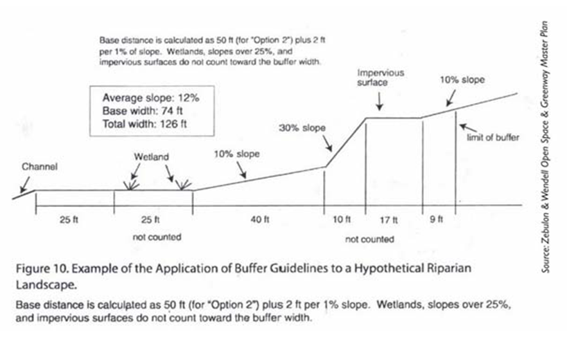
B.
General Provisions.
1.
Buffer areas must be clearly delineated on all site plans, including construction plans, grading and clearing plans, and erosion and sediment control plans.
2.
Buffer boundaries must be marked on site prior to any land disturbing activities.
3.
Buffer areas as well as all buffer requirements must be specified on the recorded plat, on individual deeds, and in property association documents.
4.
Public infrastructure such as road crossings and utility lines are allowed where no practical alternative exists, but these activities should minimize impervious surface area and avoid large amounts of vegetation removal by crossing the buffer at a minimum 75-degree angle.
(Ord. No. O-4-2017, § 4, 1-9-2017; Ord. No. O-07-2021, § 2, 2-22-2021; Ord. No. O-16-2021, § 1, 4-26-2021; Ord. No. O-17-2022, § 1, 6-13-2022; Ord. No. O-06-2024, § 1, 4-22-2024)
6.8 - Flood Damage Protection Ordinance
A.
Statutory Authorization. The Legislature of the State of North Carolina has in Part 6, Article 21 of Chapter 143; Chapter 160D-923 of enacted legislation; and Article 8 of Chapter 160A of the North Carolina General Statutes, delegated the responsibility to local governmental units to adopt regulations designed to promote the public health, safety, and general welfare of its citizenry. Therefore, the Board of Commissioners of the Town of Wendell, North Carolina, does ordain as follows:
B.
Findings of Fact.
1.
The flood prone areas within the jurisdiction of The Town of Wendell are subject to periodic inundation which results in loss of life, property, health and safety hazards, disruption of commerce and governmental services, extraordinary public expenditures of flood protection and relief, and impairment of the tax base, all of which adversely affect the public health, safety, and general welfare.
2.
Those flood losses are caused by the cumulative effect of obstructions by materials such as trees, limbs, sediment, construction debris, etc. in floodplains causing increases in flood heights and velocities, and by the occupancy in flood prone areas by uses vulnerable to floods or hazardous to other lands which are inadequately elevated, flood-proofed, or otherwise unprotected from flood damages.
C.
Statement of Purpose. It is the purpose of this section to promote public health, safety, and general welfare and to minimize public and private losses due to flood conditions within flood prone areas and provisions designed to:
1.
Restrict or prohibit uses which are dangerous to health, safety, and property due to water or erosion hazards, or which result in damaging increases in erosion, flood heights or velocities.
2.
Require that uses vulnerable to floods, including facilities which serve such uses, be protected against flood damage at the time of initial construction.
3.
Control the alteration of natural floodplains, stream channels, and natural protective barriers, which are involved in the accommodation of flood waters.
4.
Control filling, grading, dredging, and all other development which may increase erosion or flood damage; and,
5.
Prevent or regulate the construction of flood barriers which will unnaturally divert floodwaters, or which may increase flood hazards to other lands.
D.
Objectives. The objectives of this Ordinance are:
1.
To protect human life and health.
2.
To minimize expenditure of public money for costly flood control projects.
3.
To minimize the need for rescue and relief efforts associated with flooding and generally undertaken at the expense of the public.
4.
To minimize prolonged business losses and interruptions.
5.
To minimize damage to public facilities and utilities (i.e., water and gas mains, electric, telephone, cable and sewer lines, streets, and bridges) that are in flood prone areas.
6.
To help maintain a stable tax base by providing for the sound use and development of flood prone areas in such a manner as to minimize flood blight areas; and,
7.
To ensure that potential homebuyers are notified that property is in a Special Flood Hazard Area.
E.
Definitions. Unless specifically defined below, words or phrases used in this ordinance shall be interpreted to give them the meaning they have in common usage and to give this ordinance its most reasonable application.
Accessory Structure (Appurtenant Structure) means a structure which is located on the same parcel of property as the principal structure and the use of which is incidental to the use of the principal structure. Garages, carports and storage sheds are common urban accessory structures. Pole barns, hay sheds and the like qualify as accessory structures on farms and may or may not be located on the same parcel as the farm dwelling or shop building.
Addition (to an existing building) means an extension or increase in the floor area or height of a building or structure.
An administrator is the individual appointed to administer and enforce the floodplain management regulations.
Appeal means a request for a review of the Administrator's interpretation of any provision of this ordinance.
Area of Special Flood Hazard. See "Special Flood Hazard Area (SFHA)."
Basement means any area of the building having its floor subgrade (below ground level) on all sides.
Base Flood means the flood having a one percent chance of being equaled or exceeded in any given year.
Base Flood Elevation (BFE) means a determination of the water surface elevations of the base flood based on current conditions hydrology as published in the Flood Insurance Study. When the BFE has not been provided in a "Special Flood Hazard Area," it may be obtained from engineering studies available from a Federal or State other source using FEMA approved engineering methodologies. This elevation, when combined with the "Freeboard," establishes the "Regulatory Flood Protection Elevation" in Special Flood Hazard Areas.
Building. See "Structure."
Chemical Storage Facility means a building, portion of a building, or exterior area adjacent to a building used for the storage of any chemical or chemically reactive products.
Current Conditions Hydrology means the flood discharges associated with the land-use conditions existing within the drainage area of a watercourse at the time a flood study of the watercourse was conducted. Current conditions flood discharges and historical flood study information is published in the Flood Insurance Study.
Development means any man-made change to improved or unimproved real estate, including, but not limited to, buildings or other structures, mining, dredging, filling, grading, paving, excavation or drilling operations, or storage of equipment or materials.
Disposal means, as defined in N.C.G.S. 130A-290(a)(6), the discharge, deposit, injection, dumping, spilling, leaking, or placing of any solid waste into or on any land or water so that the solid waste or any constituent part of the solid waste may enter the environment or be emitted into the air or discharged into any waters, including groundwaters.
Elevated Building means a non-basement building which has its reference level raised above ground level by foundation walls, shear walls, posts, piers, pilings, or columns.
Encroachment means the advance or infringement of uses, fill, excavation, buildings, permanent structures or development into a floodplain, which may impede or alter the flow capacity of a floodplain.
Existing Manufactured Home Park or Manufactured Home Subdivision means a manufactured home park or subdivision for which the construction of facilities for servicing the lots on which the manufactured homes are to be affixed (including, at a minimum, the installation of utilities, the construction of streets, and either final site grading or the pouring of concrete pads) was completed before the original effective date of the floodplain management regulations adopted by the community.
Flood or Flooding means a general and temporary condition of partial or complete inundation of normally dry land areas from the overflow of inland or tidal waters; and/or the unusual and rapid accumulation of runoff of surface waters from any source.
Flood Hazard Boundary Map (FHBM) means an official map of a community, issued by the Federal Emergency Management Agency, where the boundaries of the Special Flood Hazard Areas have been defined as Zone A.
Flood Insurance means the insurance coverage provided under the National Flood Insurance Program.
Flood Insurance Rate Map (FIRM) means an official map of a community, issued by the Federal Emergency Management Agency, on which both the Special Flood Hazard Areas and the risk premium zones applicable to the community are delineated.
Flood Insurance Study (FIS) means an examination, evaluation, and determination of flood hazard areas, corresponding water surface elevations (if appropriate), flood insurance risk zones, and other flood data in a community issued by FEMA. The Flood Insurance Study report includes Flood Insurance Rate Maps (FIRMs) and Flood Boundary and Floodway Maps (FBFMs), if published.
Floodplain or Flood Prone Area means any land area susceptible to being inundated by water from any source.
Floodplain Development Permit means any type of permit that is required in conformance with the provisions of this ordinance, prior to the commencement of any development activity.
Floodplain Management means the operation of an overall program of corrective and preventive measures for reducing flood damage and preserving and enhancing, where possible, natural resources in the floodplain, including but not limited to emergency preparedness plans, flood control works, floodplain management regulations, and open space plans.
Floodplain Management Regulations means this ordinance and other zoning ordinances, subdivision regulations, building codes, health regulations, special purpose ordinances, and other applications of police power which control development in flood-prone areas. This term describes federal, state or local regulations, in any combination thereof, which provide standards for preventing and reducing flood loss and damage.
Floodproofing means any combination of structural and nonstructural additions, changes, or adjustments to structures, which reduce or eliminate risk of flood damage to real estate or improved real property, water and sanitation facilities, or structures with their contents.
Floodway means the channel of a river or other watercourse and the adjacent land areas that must be reserved in order to discharge the base flood without cumulatively increasing the water surface elevation more than one foot.
Flood Zone means a geographical area shown on a Flood Hazard Boundary Map or Flood Insurance Rate Map that reflects the severity or type of flooding in the area.
Freeboard means the height added to the Base Flood Elevation (BFE) or the Future Conditions Flood Elevation to account for the many unknown factors that could contribute to flood heights greater than the height calculated for a selected size flood and floodway conditions, such as wave action, bridge openings, and the hydrological effect of urbanization on the watershed. The Base Flood Elevation plus the freeboard establishes the "Regulatory Flood Protection Elevation."
Functionally Dependent Facility means a facility which cannot be used for its intended purpose unless it is located in close proximity to water, such as a docking or port facility necessary for the loading and unloading of cargo or passengers, shipbuilding, or ship repair. The term does not include long-term storage, manufacture, sales, or service facilities.
Future Conditions Flood means the flood having a one percent chance of being equaled or exceeded in any given year based on future conditions hydrology.
Future Conditions Flood Elevation means a determination of the water surface elevations of the one percent annual chance flood based on future conditions hydrology as published in the Flood Insurance Study. This elevation, when combined with the freeboard, establishes the "Regulatory Flood Protection Elevation" in Future Conditions Flood Hazard Areas.
Future Conditions Flood Hazard Area means the land area that would be inundated by the one percent annual chance flood based on future conditions hydrology as determined in Article 3, Section B of this ordinance.
Future Conditions Hydrology means the flood discharges associated with projected land-use conditions based Wake County's current countywide equivalent zoning classification data on the Town of Wendell's current Zoning Map and without consideration of projected future construction of flood detention structures or projected future hydraulic modifications within a stream or other waterway such as bridge and culvert construction, fill, and excavation. Future conditions flood discharges are published in the Flood Insurance Study.
Hazardous Waste Management Facility means a facility for the collection, storage, processing, treatment, recycling, recovery, or disposal of hazardous waste as defined in N.C.G.S. Article 9 of Chapter 130A.
Highest Adjacent Grade (HAG) means the highest natural elevation of the ground surface, prior to construction, next to the proposed walls of the structure.
Historic Structure means any structure that is:
Listed individually in the National Register of Historic Places (a listing maintained by the US Department of Interior) or preliminarily determined by the Secretary of Interior as meeting the requirements for individual listing on the National Register.
Certified or preliminarily determined by the Secretary of Interior as contributing to the historical significance of a registered historic district or a district preliminarily determined by the Secretary to qualify as a registered historic district.
Individually listed on a local inventory of historic landmarks in communities with a "Certified Local Government (CLG) Program"; or
Certified as contributing to the historical significance of a historic district designated by a community with a "Certified Local Government (CLG) Program." Certified Local Government (CLG) Programs are approved by the US Department of the Interior in cooperation with the North Carolina Department of Cultural Resources through the State Historic Preservation Officer as having met the requirements of the National Historic Preservation Act of 1966 as amended in 1980.
Lowest Adjacent Grade (LAG) means the elevation of the ground, sidewalk, patio slab, or deck support immediately next to the building after completion of the building. For Zone A and AO, use the natural grade elevation prior to construction.
Lowest Floor means the subfloor, top of slab or grade of the lowest enclosed area (including basement). An unfinished or flood resistant enclosure, usable solely for parking of vehicles, building access, or limited storage in an area other than a basement area is not considered a building's lowest floor provided that such an enclosure is not built so as to render the structure in violation of the applicable non-elevation design requirements of this ordinance.
Manufactured Home means a structure, transportable in one or more sections, which is built on a permanent chassis and designed to be used with or without a permanent foundation when connected to the required utilities. The term "manufactured home" does not include a "recreational vehicle."
Market Value means the building value, excluding the land (as agreed to between a willing buyer and seller), as established by what the local real estate market will bear. Market value can be established by independent certified appraisal; replacement cost depreciated by age of building (Actual Cash Value) or adjusted assessed values.
Mean Sea Level means, for purposes of the NFIP, the National Geodetic Vertical Datum (NGVD) as corrected in 1929, the North American Vertical Datum (NAVD) as corrected in 1988 or other vertical control datum used as a reference for establishing varying elevations within the floodplain, to which Base Flood Elevations (BFEs) shown on a FIRM are referenced. Refer to each FIRM panel to determine datum used.
New Construction means structures for which the "start of construction" commenced on or after the effective date of the original version of this ordinance and includes any subsequent improvements to such structures.
Non-Encroachment Area means the channel of a river or other watercourse and the adjacent land areas that must be reserved in order to discharge the base flood without cumulatively increasing the water surface elevation more than one foot as designated in the Flood Insurance Study report.
Post-FIRM means construction or other development for which the "start of construction" occurred on or after the effective date of the initial Flood Insurance Rate Map for the area.
Pre-FIRM means construction or other development for which the "start of construction" occurred before the effective date of the initial Flood Insurance Rate Map for the area.
Principally Above Ground means that at least 51 percent of the actual cash value of the structure is above ground.
Public Safety and/orNuisance means anything which is injurious to the safety or health of an entire community or neighborhood, or any considerable number of persons, or unlawfully obstructs the free passage or use, in the customary manner, of any navigable lake, or river, bay, stream, canal, or basin.
Recreational Vehicle (RV) means a vehicle, which is:
Built on a single chassis.
400 square feet or less when measured at the largest horizontal projection.
Designed to be self-propelled or permanently towable by a light duty truck; and,
Designed primarily not for use as a permanent dwelling, but as temporary living quarters for recreational, camping, travel, or seasonal use.
Reference Level is the top of the lowest floor for structures within Special Flood Hazard Areas and Future Conditions Flood Hazard Areas designated as Zone AE, A, A99 or X (Future).
Regulatory Flood Protection Elevation means the elevation above mean sea level to which the reference level of all structures and other development located within Special Flood Hazard Areas and Future Conditions Flood Hazard Areas must be protected.
In "Special Flood Hazard Areas" where Base Flood Elevations (BFEs) have been determined, this elevation shall be the BFE plus three feet of freeboard.
In "Special Flood Hazard Areas" where no BFE has been established, this elevation shall be at least three feet above the highest adjacent grade.
In Future Conditions Flood Hazard Areas this elevation shall be the Future Conditions Flood Elevation plus three feet of freeboard.
Remedy a Violation means to bring the structure or other development into compliance with State or Community floodplain management regulations, or, if this is not possible, to reduce the impacts of its noncompliance. Ways that impacts may be reduced include protecting the structure or other affected development from flood damages, implementing the enforcement provisions of the ordinance, or otherwise deterring future similar violations, or reducing Federal financial exposure regarding the structure or other development.
Riverine means relating to, formed by, or resembling a river (including tributaries), stream, brook, etc.
Salvage Yard means property used for the storage, collection, and/or recycling of any type of equipment whatsoever, whether industrial or noncommercial, and including but not limited to vehicles, appliances and related machinery.
Shear Walls contains the vertical elements of the horizontal wall resisting system, typically wood covered with a structural sheathing material like plywood. When properly installed the shear wall will have the strength and stiffness to resist the horizontal forces.
Solid Waste Disposal Facility means any facility involved in the disposal of solid waste, as defined in N.C.G.S. 130A-290(a)(35).
Solid Waste Disposal Site means, as defined in (N.C.G.S. 130A-290(a)(36), any place at which solid wastes are disposed of by incineration, sanitary landfill, or any other method.
Special Flood Hazard Area (SFHA) means the land in the floodplain subject to a one percent or greater chance of being flooded in any given year based on current conditions hydrology, as determined in Section F.2 of this ordinance.
Start of Construction includes substantial improvement and means the date the building permit was issued provided the actual start of construction, repair, reconstruction, rehabilitation, addition placement, or other improvement was within 180 days of the permit date. The actual start means either the first placement of permanent construction of a structure (including a manufactured home) on a site, such as the pouring of slabs or footings, installation of piles, construction of columns, or any work beyond the stage of excavation; or the placement of a manufactured home on a foundation. Permanent construction does not include land preparation, such as clearing, grading, and filling; nor does it include the installation of streets and/or walkways; nor does it include excavation for a basement, footings, piers, or foundations or the erection of temporary forms; nor does it include the installation on the property of accessory buildings, such as garages or sheds not occupied as dwelling units or not part of the main structure. For a substantial improvement, the actual start of construction means the first alteration of any wall, ceiling, floor, or other structural part of the building, whether or not that alteration affects the external dimensions of the building.
Structure means a walled and roofed building, a manufactured home.
Substantial Damage means damage of any origin sustained by a structure during any one-year period whereby the cost of restoring the structure to its before damaged condition would equal or exceed 50 percent of the market value of the structure before the damage occurred. See definition of "Substantial Improvement." Substantial Damage also means flood-related damage sustained by a structure on two separate occasions during a ten-year period for which the cost of repairs at the time of each such flood event, on the average, equals or exceeds 25 percent of the market value of the structure before the damage occurred.
Substantial Improvement means any combination of repairs, reconstruction, rehabilitation, addition, or other improvement of a structure, taking place during any one-year period whereby the cost of which equals or exceeds 50 percent of the market value of the structure before the "start of construction" of the improvement. This term includes structures which have incurred "Substantial Damage," regardless of the actual repair work performed. The term does not, however, include either:
Any correction of existing violations of State or Community health, sanitary, or safety code specifications which have been identified by the community code enforcement official and which are the minimum necessary to assure safe living conditions; or,
Any alteration of a historic structure, provided that the alteration will not preclude the structure's continued designation as a historic structure.
Variance is a grant of relief from the requirements of this ordinance.
Violation means the failure of a structure or other development to be fully compliant with the community's floodplain management regulations. A structure or other development without the elevation certificate, other certifications, or other evidence of compliance required in Sections J and G is presumed to be in violation until such time as that documentation is provided.
Water Surface Elevation (WSE) means the height, in relation to mean sea level, of floods of various magnitudes and frequencies in the floodplains of coastal or ravine areas.
Watercourse means a lake, river, creek, stream, wash, channel or other topographic feature on or over which waters flow at least periodically. Watercourse includes specifically designated areas in which substantial flood damage may occur.
F.
General Provisions.
1.
Applicable Lands. This ordinance shall apply to all Special Flood Hazard Areas and Future Conditions Flood Hazard Areas within the jurisdiction, including Extra-Territorial Jurisdictions if applicable, of the Town of Wendell and within the jurisdiction of any other community whose governing body agrees, by resolution, to such applicability.
2.
Basis for Establishing the Special Flood Hazard Areas and Future Conditions Flood Hazard Areas. The Special Flood Hazard Areas and Future Conditions Flood Hazard Areas are those identified under the Cooperating Technical State (CTS) agreement between the State of North Carolina and FEMA in its Flood Insurance Study (FIS) and its accompanying Flood Insurance Rate Maps (FIRM) which are adopted by reference and declared to be a part of this ordinance.
3.
Establishment of a Floodplain Development Permit. A Floodplain Development Permit shall be required in conformance with the provisions of this ordinance prior to the commencement of any development activities within Special Flood Hazard Areas and Future Conditions Flood Hazard Areas determined in Section F.2.
4.
Compliance. No structure or land shall hereafter be located, extended, converted, altered, or developed in any way without full compliance with the terms of this section and other applicable regulations.
5.
Abrogation and Greater Restrictions. This ordinance is not intended to repeal, abrogate, or impair any existing easements, covenants, or deed restrictions. However, where this ordinance and another conflict or overlap, whichever imposes the more stringent restrictions shall prevail.
6.
Interpretation. In the interpretation and application of this ordinance, all provisions shall be:
a.
Considered as minimum requirements.
b.
Liberally construed in favor of the governing body; and,
c.
Deemed neither to limit nor repeal any other powers granted under NC statutes.
7.
Warning and Disclaimer of Liability. The degree of flood protection required by this ordinance is considered reasonable for regulatory purposes and is based on scientific and engineering consideration. Larger floods can and will occur. Actual flood heights may be increased by man-made or natural causes. This ordinance does not imply that land outside the Special Flood Hazard Areas and Future Conditions Flood Hazard Areas or uses permitted within such areas will be free from flooding or flood damage. This ordinance shall not create liability on the part of the Town of Wendell or by any officer or employee thereof for any flood damage that results from reliance on this ordinance, or any administrative decision lawfully made hereunder.
8.
Penalties for Violation. Violation of the provisions of this ordinance or failure to comply with any of its requirements, including violation of conditions and safeguards established in connection with grants of variance, shall constitute a misdemeanor. Any person who violates this ordinance or fails to comply with any of its requirements shall, upon conviction thereof, be fined not more than $100.00 or imprisoned for not more than 30 days, or both. Each day such violation continues shall be considered a separate offense. Nothing herein contained shall prevent the Town of Wendell from taking such other lawful action as is necessary to prevent or remedy any violation.
G.
Provisions for Flood Hazard Reduction.
1.
General Standards. All developments and redevelopments shall be in accordance with the following provisions:
a.
No development or redevelopment is permitted within the Special Flood Hazard Area or Neuse River Buffer Zone except for stream bank or shoreline restoration or stabilization, water dependent structures, and public or private projects such as greenways, parks, and their accessory uses.
b.
Permitted activities within the Flood Protection Zones shall minimize impervious coverage and direct runoff away from surface waters.
c.
All development and/or substantial improvements shall be designed (or modified) and adequately anchored to prevent flotation, collapse, and lateral movement of the structure.
d.
All development and substantial improvements shall be constructed with materials and utility equipment resistant to flood damage.
e.
All development and substantial improvements shall be constructed by methods and practices that minimize flood damages.
f.
Electrical, heating, ventilation, plumbing, air conditioning equipment, and other service facilities shall be designed and/or located to prevent water from entering or accumulating within the components during conditions of flooding. These include, but are not limited to, HVAC equipment, water softener units, bath/kitchen fixtures, ductwork, electric/gas meter panels/boxes, utility/cable boxes, appliances (washers, dryers, refrigerators, freezers, etc.), hot water heaters, and electric outlets/switches.
g.
All new and replacement water supply systems shall be designed to minimize or eliminate infiltration of floodwaters into the system.
h.
New and replacement sanitary sewage systems shall be designed to minimize or eliminate infiltration of floodwaters into the systems and discharges from the systems into flood waters.
i.
On-site waste disposal systems shall be located and constructed to avoid impairment to them or contamination from them during flooding.
j.
This ordinance shall prevent the repair, reconstruction, or replacement of a building or structure, as allowed under G.1.a., and in existence on the effective date of this ordinance and located totally or partially within the floodway, non-encroachment area, or stream setback, provided there is no additional encroachment below the regulatory flood protection elevation in the floodway, non-encroachment area, or stream setback, and provided that such repair, reconstruction, or replacement meets all of the other requirements of this ordinance.
k.
A structure or tank for chemical or fuel storage incidental to an allowed use or to the operation of a water treatment plant or wastewater treatment facility may be in a Special Flood Hazard Area or Future Conditions Flood Hazard Area only if the structure or tank is either elevated or floodproofed to at least the regulatory flood protection elevation and certified according to Section J.2. of this ordinance.
l.
All subdivision and other development proposals shall be constructed to minimize flood damage.
i.
All subdivision and development proposals shall have public utilities and facilities such as sewer, gas, electrical, and water systems located and constructed to minimize flood damage.
m.
All subdivision proposals and other development proposals shall have adequate drainage provided to reduce exposure to flood hazards.
n.
All subdivision and development proposals shall have received all necessary permits from those governmental agencies for which approval is required by Federal or State law, including Section 404 of the Federal Water Pollution Control Act Amendments of 1972, 33 U.S.C. 1334.
2.
Specific Standards. In all Special Flood Hazard Areas where Base Flood Elevation (BFE) data has been provided and in Future Conditions Flood Hazard Areas where Future Conditions Flood Elevations data has been provided, as set forth in Section F.2, or Section J.3.k and l, the following provisions, in addition to those provisions in Section 6.8.G.1, are required:
a.
Residential Construction. New construction and substantial improvement of any residential structure (including manufactured homes) shall have the reference level, including basement, elevated no lower than the Regulatory Flood Protection Elevation, as defined in Section E. of this ordinance.
b.
Non-Residential Construction. New construction and substantial improvement of any commercial, industrial, or other non-residential structure shall have the reference level, including basement, elevated no lower than the Regulatory Flood Protection Elevation, as defined in Section E. of this ordinance. Structures located in Zones A, AE, AH, AO, A99, and X (Future) may be floodproofed to the Regulatory Flood Protection Elevation in lieu of elevation provided that all areas of the structure, together with attendant utility and sanitary facilities, below the Regulatory Flood Protection Elevation are watertight with walls substantially impermeable to the passage of water, using structural components having the capability of resisting hydrostatic and hydrodynamic loads and the effect of buoyancy. For AO Zones, the floodproofing elevation shall be in accordance with Section K.2. A registered professional engineer or architect shall certify that the floodproofing standards of this subsection are satisfied. Such certification shall be provided to the Floodplain Administrator as set forth in Section M.2.c. along with the operational plan and the inspection and maintenance plan.
c.
Manufactured Homes.
i.
New and replacement manufactured homes shall be elevated so that the reference level of the manufactured home is no lower than the Regulatory Flood Protection Elevation, as defined in Section E of this ordinance.
ii.
Manufactured homes shall be securely anchored to an adequately anchored foundation to resist flotation, collapse, and lateral movement, either by certified engineered foundation system, or in accordance with the most current edition of the State of North Carolina Regulations for Manufactured Homes adopted by the Commissioner of Insurance pursuant to N.C.G.S. 143-143.15. Additionally, when the elevation would be met by an elevation of the chassis 36 inches or less above the grade at the site, the chassis shall be supported by reinforced piers or engineered foundation. When the elevation of the chassis is above 36 inches in height, an engineering certification is required.
iii.
All enclosures or skirting below the lowest floor shall meet the requirements of Section G.2.d. of this ordinance.
iv.
An evacuation plan must be developed for evacuation of all residents of all new, substantially improved or substantially damaged manufactured home parks or subdivisions located within flood prone areas. This plan shall be filed with and approved by the Floodplain Administrator and the local Emergency Management Coordinator.
d.
Elevated Buildings. Fully enclosed area, of new construction and substantially improved structures, which is below the lowest floor:
i.
Shall not be designed or used for human habitation, but shall only be used for parking of vehicles, building access, or limited storage of maintenance equipment used in connection with the premises. Access to the enclosed area shall be the minimum necessary to allow for parking of vehicles (garage door) or limited storage of maintenance equipment (standard exterior door). The interior portion of such enclosed area shall not be finished or partitioned into separate rooms, except to enclosed storage areas.
ii.
Shall be constructed entirely of flood resistant materials below the regulatory flood protection elevation.
iii.
Shall include, in Zones A, AE and X (Future), flood openings to automatically equalize hydrostatic flood forces on walls by allowing for the entry and exit of floodwaters. To meet this requirement, the openings must either be certified by a professional engineer or architect or meet or exceed the following minimum design criteria.
a.
A minimum of two flood openings on different sides of each enclosed area subject to flooding.
b.
The total net area of all flood openings must be at least 1 square inch for each square foot of enclosed area subject to flooding.
c.
If a building has more than one enclosed area, each enclosed area must have flood openings to allow floodwaters to automatically enter and exit.
d.
The bottom of all required flood openings shall be no higher than one foot above the adjacent grade.
e.
Flood openings may be equipped with screens, louvers, or other coverings or devices, provided they permit the automatic flow of floodwaters in both directions; and
f.
Enclosures made of flexible skirting are not considered enclosures for regulatory purposes, and, therefore, do not require flood openings. Masonry or wood underpinning, regardless of structural status, is considered an enclosure and requires flood openings as outlined above.
e.
Additions/Improvements:
i.
Additions and/or improvements to pre-FIRM structures when the addition and/or improvements in combination with any interior modifications to the existing structure are:
a.
Not a substantial improvement, shall be designed to minimize flood damages and must not be any more non-conforming than the existing structure.
b.
No substantial improvements are permitted within the flood hazard area.
ii.
Additions to post-FIRM structures with no modifications to the existing structure other than a standard door in the common wall shall require only the addition to comply with the standards for new construction.
iii.
Additions and/or improvements to post-FIRM structures when the addition and/or improvements in combination with any interior modifications to the existing structure are:
a.
Not a substantial improvement, the addition and/or improvements only must comply with the standards for new construction.
b.
A substantial improvement, both the existing structure and the addition and/or improvements must comply with the standards for new construction.
c.
Where an independent perimeter load-bearing wall is provided between the addition and the existing building, the addition(s) shall be considered a separate building and only the addition must comply with the standards for new construction.
f.
Recreational Vehicles: Recreation vehicles shall either:
i.
Temporary Placement
a.
Be on site for fewer than 180 consecutive days; or
b.
Be fully licensed and ready for highway use (a recreational vehicle is ready for highway use if it is on its wheels or jacking system, is attached to the site only by quick disconnect type utilities and has no permanently attached additions).
ii.
Permanent Placement. Recreational vehicles that do not meet the limitations of Temporary Placement shall meet all the requirements for new construction.
g.
Temporary Non-Residential Structures. Prior to the issuance of a floodplain development permit for a temporary structure, the applicant must submit to the Floodplain Administrator a plan for the removal of such structure(s) in the event of a hurricane, flash flood or other type of flood warning notification. The following information shall be submitted in writing to the Floodplain Administrator for review and written approval:
i.
A specified time period for which the temporary use will be permitted. Time specified may not exceed three months, renewable up to one year;
ii.
The name, address, and phone number of the individual responsible for the removal of the temporary structure;
iii.
The time frame prior to the event at which a structure will be removed (i.e., minimum of 72 hours before landfall of a hurricane or immediately upon flood warning notification);
iv.
A copy of the contract or other suitable instrument with the entity responsible for physical removal of the structure; and
v.
Designation, accompanied by documentation, of a location outside the Special Flood Hazard Area or Future Conditions Flood Hazard Area, to which the temporary structure will be moved.
h.
Accessory Structures. When accessory structures (sheds, detached garages, etc.) are to be placed within a Special Flood Hazard Area or Future Conditions Flood Hazard Area, the following criteria shall be met:
i.
Accessory structures shall not be used for human habitation (including working, sleeping, living, cooking or restroom areas);
ii.
Accessory structures shall not be temperature-controlled
iii.
Accessory structures shall be designed to have low flood damage potential;
iv.
Accessory structures shall be constructed and placed on the building site so as to offer the minimum resistance to the flow of floodwaters;
v.
Accessory structures shall be firmly anchored in accordance with the provisions of Section G.1.c.;
vi.
All service facilities such as electrical shall be installed in accordance with the provisions of Section G.1.f.; and
vii.
Flood openings to facilitate automatic equalization of hydrostatic flood forces shall be provided below Regulatory Flood Protection Elevation in conformance with the provisions of Section G.2.d.iv.
viii.
An accessory structure with a footprint less than 144 square feet or that is a minimal investment of $3,000.00 or less and satisfies the criteria outlined above is not required to meet the elevation or floodproofing standards of Section G.2.b. Elevation or floodproofing certifications are required for all other accessory structures in accordance with Section M.2.c.
i.
Tanks. When gas and liquid storage tanks are to be placed within a Special Flood Hazard Area or Future Conditions Flood Hazard Area, the following criteria shall be met:
i.
Underground tanks. Underground tanks in flood hazard areas shall be anchored to prevent flotation, collapse or lateral movement resulting from hydrodynamic and hydrostatic loads during conditions of the design flood, including the effects of buoyancy assuming the tank is empty;
ii.
Above-ground tanks, elevated. Above-ground tanks in flood hazard areas shall be elevated to or above the Regulatory Flood Protection Elevation on a supporting structure that is designed to prevent flotation, collapse or lateral movement during conditions of the design flood. Tank-supporting structures shall meet the foundation requirements of the applicable flood hazard area;
iii.
Above-ground tanks not elevated. Above-ground tanks that do not meet the elevation requirements of Section G.2.b of this ordinance shall be permitted in flood hazard areas provided the tanks are designed, constructed, installed, and anchored to resist all flood-related and other loads, including the effects of buoyancy, during conditions of the design flood and without release of contents in the floodwaters or infiltration by floodwaters into the tanks. Tanks shall be designed, constructed, installed, and anchored to resist the potential buoyant and other flood forces acting on an empty tank during design flood conditions.
iv.
Tank inlets and vents. Tank inlets, fill openings, outlets and vents shall be:
a.
At or above the Regulatory Flood Protection Elevation or fitted with covers designed to prevent the inflow of floodwater or outflow of the contents of the tanks during conditions of the design flood; and
b.
Anchored to prevent lateral movement resulting from hydrodynamic and hydrostatic loads, including the effects of buoyancy, during conditions of the design flood.
j.
Other Development.
i.
Fences in regulated floodways and NEAs that have the potential to block the passage of floodwaters, such as stockade fences and wire mesh fences, shall meet the limitations of Section J of this ordinance.
ii.
Retaining walls, sidewalks and driveways in regulated floodways and NEAs. Retaining walls and sidewalks and driveways that involve the placement of fill in regulated floodways shall meet the limitations of Section J of this ordinance.
iii.
Roads and watercourse crossings in regulated floodways and NEAs. Roads and watercourse crossings, including roads, bridges, culverts, low-water crossings and similar means for vehicles or pedestrians to travel from one side of a watercourse to the other side, that encroach into regulated floodways shall meet the limitations of Section J of this ordinance.
H.
Standards for Floodplains without Established Base Flood Elevations. Within the Special Flood Hazard Areas designated as Approximate Zone A and established Section F.2, where no Base Flood Elevation (BFE) data has been provided by FEMA, the following provisions, in addition to Sections G.1 and G.2, shall apply:
1.
No encroachments, including fill, new development, or substantial improvements shall be permitted within a distance of 50 feet each side from top of bank or five times the width of the stream on each side whichever is greater, unless certification with supporting technical data by a registered professional engineer is provided demonstrating that such encroachments shall not result in any increase in flood levels during the occurrence of the base flood discharge.
2.
The BFE used in determining the regulatory flood protection elevation shall be determined based on one of the following criteria set in priority order:
a.
If Base Flood Elevation (BFE) data is available from other sources, all new construction and substantial improvements within such areas shall also comply with all applicable provisions of this ordinance and shall be elevated or floodproofed in accordance with standards in Sections J.3.k and l.
b.
All subdivision, manufactured home park and other development proposals shall provide Base Flood Elevation (BFE) data if development is greater than five acres or has more than 50 lots/manufactured home sites. Such Base Flood Elevation (BFE) data shall be adopted by reference per Section F.2 to be utilized in implementing this ordinance.
c.
When Base Flood Elevation (BFE) data is not available from a Federal, State, or other source as outlined above, the reference level shall be elevated to or above the regulatory flood protection elevation, as defined in Section F.2.
I.
Standards for Riverine Floodplains with Base Flood Elevations but Without Established Floodways or Non-Encroachment Areas. Along rivers and streams where BFE data is provided by FEMA or is available from another source but neither floodway nor non-encroachment areas are identified for a Special Flood Hazard Area on the FIRM or in the FIS report, the following requirements shall apply to all development within such areas:
1.
Standards of Sections G.1 and G.2; and
2.
Until a regulatory floodway or non-encroachment area is designated, no encroachments, including fill, new construction, substantial improvements, or other development, shall be permitted unless certification with supporting technical data by a registered professional engineer is provided demonstrating that the cumulative effect of the proposed development, when combined with all other existing and anticipated development, will not increase the water surface elevation of the base flood more than one foot at any point within the community.
J.
Floodways and Non-Encroachment Areas. Areas designated as floodways or non-encroachment areas are located within the Special Flood Hazard Areas established in Section F.2. The floodways and non-encroachment areas are extremely hazardous areas due to the velocity of floodwaters that have erosion potential and carry debris and potential projectiles. The following provisions, in addition to standards outlined in Sections G.1 and G.2, shall apply to all development within such areas:
1.
No encroachments, including fill, new construction, substantial improvements and other developments in accordance with G.1.a. shall be permitted unless it has been demonstrated that:
a.
The proposed encroachment would not result in any increase in the flood levels during the occurrence of the base flood, based on hydrologic and hydraulic analyses performed in accordance with standard engineering practice and presented to the Administrator prior to issuance of floodplain development permit, or
b.
A Conditional Letter of Map Revision (CLOMR) has been approved by FEMA. A Letter of Map Revision (LOMR) must also be obtained upon completion of the proposed encroachment.
2.
If Section I.1 is satisfied, all development shall comply with all applicable flood hazard reduction provisions of this ordinance.
3.
No new or additional manufactured homes shall be permitted, except replacement manufactured homes in an existing manufactured home park or subdivision, provided the following provisions are met:
a.
The anchoring and the elevation standards of Section G.2.c; and
b.
The no encroachment standard of Section I.1.
K.
Standards for Areas of Shallow Flooding (Zone AO). Located within the Special Flood Hazard Areas established in Section F.2, are areas designated as shallow flooding areas. These areas have special flood hazards associated with base flood depths of one to three feet where a clearly defined channel does not exist and where the path of flooding is unpredictable and indeterminate. In addition to Sections G.1 and G.2, all new construction and substantial improvements shall meet the following requirements:
1.
The reference level shall be elevated at least as high as the depth number specified on the Flood Insurance Rate Map (FIRM), in feet, plus a freeboard of three feet, above the highest adjacent grade; or at least four feet above the highest adjacent grade if no depth number is specified.
2.
Non-residential structures may, in lieu of elevation, be floodproofed to the same level as required in Section K.1 so that the structure, together with attendant utility and sanitary facilities, below that level shall be watertight with walls substantially impermeable to the passage of water and with structural components having the capability of resisting hydrostatic and hydrodynamic loads and effects of buoyancy. Certification is required in accordance with Section M.2.c and Section G.2.b.
3.
Adequate drainage paths shall be provided around structures on slopes, to guide floodwaters around and away from proposed structures.
L.
Standards for Areas of Shallow Flooding (Zone AH). Located within the Special Flood Hazard Areas established in Section F.2, are areas designated as shallow flooding areas. These areas are subject to inundation by 1-percent-annual-chance shallow flooding (usually areas of ponding) where average depths are one to three feet. Base Flood Elevations are derived from detailed hydraulic analyses are shown in this zone. In addition to Sections G.1 and G.2, all new construction and substantial improvements shall meet the following requirements:
1.
Adequate drainage paths shall be provided around structures on slopes, to guide floodwaters around and away from proposed structures.
M.
Administration.
1.
Designation of Administrator. The Administrator or his or her designee is hereby appointed to administer and implement the provisions of this ordinance.
2.
Floodplain Development Permit and Certification Requirements.
a.
Plans and Application Requirements. Application for a Floodplain Development Permit shall be made to the floodplain administrator prior to any development activities located within Special Flood Hazard Areas and Future Conditions Flood Hazard Areas. The following items shall be presented to the floodplain administrator to apply for a floodplain development permit:
i.
A plot plan drawn to scale which shall include, but shall not be limited to, the following specific details of the proposed floodplain development:
a.
The nature, location, dimensions, and elevations of the area of development/disturbance; existing and proposed structures, utility systems, grading/pavement areas, fill materials, storage areas, drainage facilities, and other development.
b.
The boundary of the Special Flood Hazard Area or Future Conditions Flood Hazard Area as delineated on the FIRM or other flood map as determined in Section F.2, or a statement that the entire lot is within the Special Flood Hazard Area or Future Conditions Flood Hazard Area.
c.
Flood zone(s) designation of the proposed development area as determined on the FIRM or other flood map as determined in Section F.2.
d.
The boundary of the floodway(s) or non-encroachment area(s) as determined in Section F.2.
e.
The Base Flood Elevation (BFE) or Future Conditions Flood Elevation where provided as set forth in Sections F.2; J.3.k and l; and G.2;
f.
The old and new location of any watercourse that will be altered or relocated because of proposed development.
g.
Certification of the plot plan by a registered land surveyor or professional engineer.
ii.
Proposed elevation, and method thereof, of all development within a Special Flood Hazard Area or Future Conditions Flood Hazard Area including but not limited to:
a.
Elevation in relation to mean sea level of the proposed reference level (including basement) of all structures.
b.
Elevation in relation to mean sea level to which any non-residential structure in Zone AE, A or X (Future) will be flood-proofed; and
c.
Elevation in relation to mean sea level to which any proposed utility systems will be elevated or floodproofed.
iii.
If floodproofing, a Floodproofing Certificate (FEMA Form 81-65) with supporting data and an operational plan that includes, but is not limited to, installation, exercise, and maintenance of floodproofing measures.
iv.
A Foundation Plan, drawn to scale, which shall include details of the proposed foundation system to ensure all provisions of this ordinance are met. These details include but are not limited to:
a.
The proposed method of elevation, if applicable (i.e., fill, solid foundation perimeter wall, solid backfilled foundation, open foundation on columns/posts/piers/piles/shear walls).
b.
Openings to facilitate equalization of hydrostatic flood forces on walls in accordance with Section G.2, when solid foundation perimeter walls are used in Zones A, AE and X (future).
v.
Usage details of any enclosed areas below the regulatory flood protection elevation.
vi.
Plans and/or details for the protection of public utilities and facilities such as sewer, gas, electrical, and water systems to be located and constructed to minimize flood damage.
vii.
Copies of all other Local, State and Federal permits required prior to floodplain development permit issuance (Wetlands, Endangered Species, Erosion and Sedimentation Control, Riparian Buffers, Mining, etc.)
viii.
Documentation for placement of Recreational Vehicles and/or Temporary Structures, when applicable, to ensure Section G.2.c and g of this ordinance are met.
ix.
A description of proposed watercourse alteration or relocation, when applicable, including an engineering report on the effects of the proposed project on the flood-carrying capacity of the watercourse and the effects to properties located both upstream and downstream; and a map (if not shown on plot plan) showing the location of the proposed watercourse alteration or relocation.
b.
Permit Requirements. The Floodplain Development permit shall include, but not be limited to:
i.
A description of the development to be permitted under the floodplain development permit.
ii.
The Special Flood Hazard Area or Future Conditions Flood Hazard Area determination for the proposed development per available data specified in Section F.2.
iii.
The regulatory flood protection elevation required for the reference level and all attendant utilities.
iv.
The regulatory flood protection elevation required for the protection of all public utilities.
v.
All certification submittal requirements with timelines.
vi.
A statement that no fill material or other development shall encroach into the floodway or non-encroachment area of any watercourse, as applicable.
vii.
The flood openings requirements, if in Zones A, AE or X (Future).
viii.
Limitations of below BFE enclosure uses, if applicable (i.e., Parking, Building Access and Limited Storage only).
ix.
A statement that all materials below BFE/RFPE must be flood resistant materials.
c.
Certification Requirements:
i.
Elevation Certificates
a.
An Elevation Certificate (FEMA Form 81-31) is required prior to the actual start of any new construction. It shall be the duty of the permit holder to submit to the floodplain administrator a certification of the elevation of the reference level, in relation to mean sea level. The floodplain administrator shall review the certificate data submitted. Deficiencies detected by such review shall be corrected by the permit holder prior to the beginning of construction. Failure to submit the certification or failure to make required corrections shall be cause to deny a floodplain development permit.
b.
An Elevation Certificate (FEMA Form 81-31) is required after the reference level is established. Within seven calendar days of establishment of the reference level elevation, it shall be the duty of the permit holder to submit to the floodplain administrator a certification of the elevation of the reference level, in relation to mean sea level. Any work done within the seven-day calendar period and prior to submission of the certification shall be at the permit holder's risk. The floodplain administrator shall review the certificate data submitted. Deficiencies detected by such review shall be corrected by the permit holder immediately and prior to further work being permitted to proceed. Failure to submit the certification or failure to make required corrections shall be cause to issue a stop-work order for the project.
c.
A final as-built Elevation Certificate (FEMA Form 81-31) is required after construction is completed and prior to Certificate of Compliance/Occupancy issuance. It shall be the duty of the permit holder to submit to the floodplain administrator a certification of final as-built construction of the elevation of the reference level and all attendant utilities. The floodplain administrator shall review the certificate data submitted. Deficiencies detected by such review shall be corrected by the permit holder immediately and prior to Certificate of Compliance/ Occupancy issuance. In some instances, another certification may be required to certify corrected as-built construction. Failure to submit the certification or failure to make required corrections shall be cause to withhold the issuance of a Certificate of Compliance/Occupancy.
ii.
Floodproofing Certificate. If non-residential floodproofing is used to meet the regulatory flood protection elevation requirements, a Floodproofing Certificate (FEMA Form 81-65), with supporting data and an operational plan, is required prior to the actual start of any new construction. It shall be the duty of the permit holder to submit to the floodplain administrator a certification of the floodproofed design elevation of the reference level and all attendant utilities, in relation to mean sea level. Floodproofing certification shall be prepared by or under the direct supervision of a professional engineer or architect and certified by same. The floodplain administrator shall review the certificate data and plan. Deficiencies detected by such review shall be corrected by the applicant prior to permit approval. Failure to submit the certification or failure to make required corrections shall be cause to deny a floodplain development permit. Failure to construct in accordance with the certified design shall be cause to withhold the issuance of a Certificate of Compliance/Occupancy.
iii.
If a manufactured home is placed within Zone A, AE or X (Future) and the elevation of the chassis is more than 36 inches in height above grade, an engineered foundation certification is required per Section G.2.c.
iv.
If a watercourse is to be altered or relocated, a description of the extent of watercourse alteration or relocation; a professional engineer's certified report on the effects of the proposed project on the flood-carrying capacity of the watercourse and the effects to properties located both upstream and downstream; and a map showing the location of the proposed watercourse alteration or relocation shall all be submitted by the permit applicant prior to issuance of a floodplain development permit.
v.
Certification Exemptions. The following structures, if located within Zone A, AE or X (Future), are exempt from the elevation/floodproofing certification requirements specified in items (1) and (2) of this subsection:
a.
Recreational Vehicles meeting requirements of Section G.2.c.i;
b.
Temporary Structures meeting requirements of Section G.2.
c.
Accessory Structures that are 144 square feet or less or $3,000.00 or less and meeting requirements of Section G.2.h.
d.
Determinations for Existing Buildings and Structures. For applications for building permits to improve buildings and structures, including alterations, movement, enlargement, replacement, repair, change of occupancy, additions, rehabilitations, renovations, substantial improvements, repairs of substantial damage, and any other improvement of or work on such buildings and structures, the Floodplain Administrator, in coordination with the Building Official, shall:
i.
Estimate the market value, or require the applicant to obtain an appraisal of the market value prepared by a qualified independent appraiser, of the building or structure before the start of construction of the proposed work; in the case of repair, the market value of the building or structure shall be the market value before the damage occurred and before any repairs are made;
ii.
Compare the cost to perform the improvement, the cost to repair a damaged building to its pre-damaged condition, or the combined costs of improvements and repairs, if applicable, to the market value of the building or structure;
iii.
Determine and document whether the proposed work constitutes substantial improvement or repair of substantial damage; and
iv.
Notify the applicant if it is determined that the work constitutes substantial improvement or repair of substantial damage and that compliance with the flood resistant construction requirements of the NC Building Code and this ordinance is required.
3.
Duties and Responsibilities of the Administrator. Duties of the Administrator shall include, but not be limited to:
a.
Review all floodplain development applications and issue permits for all proposed development within flood prone areas to assure that the requirements of this ordinance have been satisfied.
b.
Advise applicant that additional Federal or State permits (i.e., Wetlands, Erosion and Sedimentation Control, Riparian Buffers, Mining, etc.) may be required, and require that copies of such permits be provided and maintained on file with the floodplain development permit.
c.
Notify adjacent communities and the North Carolina Department of Crime Control and Public Safety, Division of Emergency Management, State Coordinator for the National Flood Insurance Program prior to any alteration or relocation of a watercourse and submit evidence of such notification to the Federal Emergency Management Agency (FEMA).
d.
Assure that maintenance is provided within the altered or relocated portion of said watercourse so that the flood-carrying capacity is not diminished.
e.
Prevent encroachments within floodways and non-encroachment areas unless the certification and flood hazard reduction provisions are met.
f.
Obtain actual elevation (in relation to mean sea level) of the reference level (including basement) of all attendant utilities of all new or substantially improved structures, in accordance with Section J.2.c.
g.
Obtain the actual elevation (in relation to mean sea level) to which the new or substantially improved structures and all utilities have been floodproofed, in accordance with Section J.2.c.
h.
Obtain actual elevation (in relation to mean sea level) of all public utilities, in accordance with Section J.2.c.
i.
When floodproofing is utilized for a particular structure, obtain certifications from a registered professional engineer or architect in accordance with Section J.2.c and Section G.2.
j.
Where interpretation is needed as to the exact location of boundaries of the Special Flood Hazard Areas or Future Conditions Flood Hazard Areas (for example, where there appears to be a conflict between a mapped boundary and actual field conditions), make the necessary interpretation. The person contesting the location of the boundary shall be given a reasonable opportunity to appeal the interpretation as provided in this article.
k.
When Base Flood Elevation (BFE) data has not been provided in accordance with Section F.2, obtain, review, and reasonably utilize any Base Flood Elevation (BFE) data, along with floodway data or non-encroachment area data available from a Federal, State, or other source, including data developed pursuant to Section G.3.b. in order to administer the provisions of this ordinance.
l.
When Base Flood Elevation (BFE) data is provided but no floodway nor non-encroachment area data has been provided in accordance with Section F.2, obtain, review, and reasonably utilize any floodway data or non-encroachment area data available from a Federal, State, or other source in order to administer the provisions of this ordinance.
m.
When the lowest ground elevation of a parcel or structure located within Zone AE is above the Base Flood Elevation (BFE), advise the property owner of the option to apply for a Letter of Map Amendment (LOMA) from FEMA. Maintain a copy of the Letter of Map Amendment (LOMA) issued by FEMA in the floodplain development permit file.
n.
Permanently maintain all records that pertain to the administration of this ordinance and make these records available for public inspection.
o.
Make on-site inspections of work in progress. As the work pursuant to a floodplain development permit progress, the floodplain administrator shall make as many inspections of the work as may be necessary to ensure that the work is being done according to the provisions of the local ordinance and the terms of the permit. In exercising this power, the floodplain administrator has a right, upon presentation of proper credentials, to enter on any premises within the jurisdiction of the community at any reasonable hour for the purposes of inspection or other enforcement action; provided, however, that the appropriate consent has been given for inspection of areas not open to the public or that an appropriate inspection warrant has been secured.
p.
Issue stop-work orders as required. Whenever a building or part thereof is being constructed, reconstructed, altered, or repaired in violation of this ordinance, the floodplain administrator may order the work to be immediately stopped. The stop-work order shall be in writing and directed to the person doing/authorizing/financing the work. The stop-work order shall state the specific work to be stopped, the specific reason(s) for the stoppage, and the condition(s) under which the work may be resumed. Violation of a stop-work order constitutes a misdemeanor.
q.
Revoke floodplain development permits as required. The floodplain administrator may revoke and require the return of the floodplain development permit by notifying the permit holder in writing stating the reason(s) for the revocation. Permits shall be revoked for any substantial departure from the approved application, plans, or specifications; for refusal or failure to comply with the requirements of State or local laws; or for false statements or misrepresentations made in securing the permit. Any floodplain development permit mistakenly issued in violation of an applicable State or local law may also be revoked.
r.
Make periodic inspections throughout all special flood hazard areas within the jurisdiction of the community. The floodplain administrator and each member of his or her inspections department shall have a right, upon presentation of proper credentials, to enter on any premises within the territorial jurisdiction of the department at any reasonable hour for the purposes of inspection or other enforcement action; provided, however, that the appropriate consent has been given for inspection of areas not open to the public or that an appropriate inspection warrant has been secured.
s.
Follow through with corrective procedures of Section J.4.
t.
Review, provide input, and make recommendations for variance requests.
u.
Maintain a current map repository to include, but not limited to, the FIS Report, FIRM and other official flood maps and studies adopted in accordance with Section F.2 of this ordinance, including any revisions thereto including Letters of Map Change, issued by FEMA. Notify State and FEMA of mapping needs.
v.
Coordinate revisions to FIS reports and FIRMs, including Letters of Map Revision Based on Fill (LOMR-F) and Letters of Map Revision (LOMR).
4.
Corrective Procedures.
a.
Violations to be Corrected: When the floodplain administrator finds violations of applicable State and local laws, it shall be his or her duty to notify the owner or occupant of the building of the violation. The owner or occupant shall immediately remedy each of the violations of law cited in such notification.
b.
Actions in Event of Failure to Take Corrective Action. If the owner of a building or property shall fail to take prompt corrective action, the Administrator shall give the owner written notice, by certified or registered mail to the owner's last known address or by personal service, stating:
i.
That the building or property is in violation of the Flood Damage Prevention Ordinance.
ii.
That a hearing will be held before the Administrator at a designated place and time, not later than ten days after the date of the notice, at which time the owner shall be entitled to be heard in person or by counsel and to present arguments and evidence pertaining to the matter; and,
iii.
That following the hearing, the Administrator may issue such order to alter, vacate, or demolish the building; or to remove fill as appears appropriate.
c.
Order to Take Corrective Action: If, upon a hearing held pursuant to the notice prescribed above, the Administrator shall find that the building or development is in violation of the Flood Damage Prevention Ordinance, he or she shall make an order in writing to the owner, requiring the owner to remedy the violation within a specified time period, not less than 60 calendar days nor more than 180 calendar days. Where the Administrator finds that there is imminent danger to life or other property, he may order that corrective action be taken in such lesser period as may be feasible.
d.
Appeal: Any owner who has received an order to take corrective action may appeal the order to the local elected governing body by giving notice of appeal in writing to the Administrator and the clerk within ten days following issuance of the final order. In the absence of an appeal, the order of the Administrator shall be final. The local governing body shall hear an appeal within a reasonable time and may affirm, modify and affirm, or revoke the order.
e.
Failure to Comply with Order: If the owner of a building or property fails to comply with an order to take corrective action from which no appeal has been taken or fails to comply with an order of the governing body following an appeal, he shall be guilty of a misdemeanor and shall be punished at the discretion of the court.
5.
Variance Procedures.
a.
The Zoning Board of Adjustment, as established by the Town of Wendell, shall hear and decide requests for variances from the requirements of this ordinance.
b.
Any person aggrieved by the decision of the Board of Adjustment may appeal such decision to the Court, as provided in Chapter 7A of the North Carolina General Statutes.
c.
Variances may be issued for:
i.
The repair or rehabilitation of historic structures upon the determination that the proposed repair or rehabilitation will not preclude the structure's continued designation as a historic structure and that the variance is the minimum necessary to preserve the historic character and design of the structure.
ii.
Functionally dependent facilities if determined to meet the definition as stated in this ordinance, provided provisions of Section J.5.i.(ii), (iii), and (iv) have been satisfied, and such facilities are protected by methods that minimize flood damages.
d.
In passing upon variances, the Board of Adjustment shall consider all technical evaluations, all relevant factors, all standards specified in other sections of this ordinance, and:
i.
The danger that materials may be swept onto other lands to the injury of others.
ii.
The danger to life, property, and environment (plant and animal life) due to flooding or erosion damage.
iii.
The susceptibility of the proposed facility and its contents to flood damage and the effect of such damage on the individual owner.
iv.
The importance of the services provided by the proposed facility to the community.
v.
The necessity to the facility of a waterfront location, where applicable.
vi.
The availability of alternative locations, not subject to flooding or erosion damage, for the proposed use.
vii.
The compatibility of the proposed use with existing and anticipated development.
viii.
The relationship of the proposed use to the comprehensive plan and floodplain management program for that area.
ix.
The safety of access to the property in times of flood for ordinary and emergency vehicles.
x.
The expected heights, velocity, duration, rate of rise, and sediment transport of the flood waters and the effects of wave action, if applicable, expected at the site; and,
xi.
The costs of providing governmental services during and after flood conditions including maintenance and repair of public utilities and facilities such as sewer, gas, electrical and water systems, and streets and bridges.
e.
A written report addressing each of the above factors shall be submitted with the application for a variance.
f.
Upon consideration of the factors listed above and the purposes of this ordinance, the Board of Adjustment may attach such conditions to the granting of variances as it deems necessary to further the purposes of this ordinance.
g.
Any applicant to whom a variance is granted shall be given written notice specifying the difference between the Base Flood Elevation (BFE) and the elevation to which the structure is to be built and that such construction below the Base Flood Elevation increases risks to life and property, and that the issuance of a variance to construct a structure below the Base Flood Elevation will result in increased premium rates for flood insurance up to $25.00 per $100.00 of insurance coverage. Such notification shall be maintained with a record of all variance actions, including justification for their issuance.
h.
The floodplain administrator shall maintain the records of all appeal actions and report any variances to the Federal Emergency Management Agency and the State of North Carolina upon request.
i.
Conditions for Variances:
i.
Variances shall not be issued when the variance will make the structure in violation of other Federal, State, or local laws, regulations, or ordinances.
ii.
Variances shall not be issued within any designated floodway or non-encroachment area if the variance would result in any increase in flood levels during the base flood discharge.
iii.
Variances shall only be issued upon a determination that the variance is the minimum necessary, considering the flood hazard, to afford relief.
iv.
Variances shall only be issued prior to development permit approval.
v.
Variances shall only be issued upon:
a.
A showing of good and sufficient cause.
b.
A determination that failure to grant the variance would result in exceptional hardship; and
c.
A determination that the granting of a variance will not result in increased flood heights, additional threats to public safety, or extraordinary public expense, create nuisance, cause fraud on or victimization of the public, or conflict with existing local laws or ordinances.
j.
A variance may be issued for solid waste disposal facilities, hazardous waste management facilities, salvage yards, and chemical storage facilities that are in Special Flood Hazard Areas or Future Conditions Flood Areas if all the following conditions are met.
i.
The use serves a critical need in the community.
ii.
No feasible location exists for the use outside the Special Flood Hazard Area or Future Conditions Flood Hazard Area.
iii.
The reference level of any structure is elevated or floodproofed to at least the regulatory flood protection level.
iv.
The use complies with all other applicable federal, state and local laws.
v.
The Town of Wendell has notified the Secretary of the North Carolina Department of Crime Control and Public Safety of its intention to grant a variance at least 30 calendar days prior to granting the variance.
N.
Legal Status
1.
Effect on Rights and Liabilities Under the Existing Flood Damage Prevention Ordinance. This ordinance in part comes forward by re-enactment of some of the provisions of the Flood Damage Prevention Ordinance enacted April 23, 2007, as amended, and it is not the intention to repeal but rather to re-enact and continue to enforce without interruption of such existing provisions, so that all rights and liabilities that have accrued thereunder are reserved and may be enforced. The enactment of this ordinance shall not affect any action, suit or proceeding instituted or pending. All provisions of the Flood Damage Prevention Ordinance of The Town of Wendell enacted on April 23, 2007, as amended, which are not reenacted herein are repealed.
2.
Effect Upon Outstanding Floodplain Development Permits. Nothing herein contained shall require any change in the plans, construction, size, or designated use of any development or any part thereof for which a floodplain development permit has been granted by the Floodplain Administrator or his or her authorized agents before the time of passage of this ordinance; provided, however, that when construction is not begun under such outstanding permit within a period of six months subsequent to the date of issuance of the outstanding permit, construction or use shall be in conformity with the provisions of this ordinance.
3.
Severability. If any section, clause, sentence, or phrase of the Ordinance is held to be invalid or unconstitutional by any court of competent jurisdiction, then said holding shall in no way effect the validity of the remaining portions of this Ordinance.
4.
Effective Date. This ordinance shall become effective upon adoption.
(Ord. No. O-06-2024, § 1, 4-22-2024)