
Wendell City Zoning Code
CHAPTER 9
CIRCULATION AND CONNECTIVITY
9.1 - Purpose and Intent
This chapter is guided by and intends to fulfill the following principle of The Town Plan of Wendell: "Ensure local and regional transportation and interconnectivity and options while also maintaining and enhancing Wendell as a walkable community." This Chapter serves to implement the policy and regulatory recommendations of the Town of Wendell Arterial and Collector Street Plan which also recognizes the importance and long-term need of new and enhanced thoroughfares throughout the community. It is the intent of this Chapter to build streets that are integral components of community design. Streets shall be detailed to complement neighborhoods and commercial centers and shall accommodate all modes of travel.
The purpose of this Chapter is to:
•
Support the creation of a highly connected transportation system within Wendell in order to provide choices for drivers, bicyclists and pedestrians;
•
Promote walking and bicycling;
•
Connect neighborhoods to each other and to local destinations such as schools, parks, and shopping centers;
•
Reduce vehicle miles of travel and travel time;
•
Reduce travel times and increase efficiency of public service delivery (e.g., school buses, refuse collection, mail delivery) and emergency responders; and
•
Reduce reliance on thoroughfares for short trips so that thoroughfares can better serve regional travel needs and widening beyond four lanes can be avoided; and
•
Ensure that pedestrian connections serve all citizens of Wendell by mandating that projects meet ADA requirements.
(Ord. No. O-20-2016, § 7, 11-14-2016)
9.2 - General Infrastructure Design Guidelines
All infrastructure shall be designed and installed in accordance with the Town's Standard Specifications and Details manual and the requirements of this chapter.
9.3 - General Provisions for Street Design
New development or redevelopment with frontages on existing publicly-maintained streets shall be required to upgrade all street frontages to meet the standards of this Ordinance including sidewalks, street trees, curb and gutter, and right-of-way dedication. Payment in lieu of physical improvements may be permitted by the Board of Commissioners.
Replacement of a single-family dwelling shall not require roadway infrastructure improvements unless said property is within 300 feet of an existing sidewalk on the same side of the street, in which case the property owner shall be responsible for installing sidewalk, curb, and gutter along their frontage.
Family subdivisions and development which consists solely of the construction of one single-family dwelling on a tract of land which is five acres or more in size and which contains no existing residences shall not be required to construct the street to the standard section and shall not be required to pay a fee in lieu of such street construction. Dedication of right-of-way along existing roads and reservation of right-of-way along future streets shall be required.
The following specifications shall apply to street design:
A.
Streets: The Town views streets as important public space and, in an effort to protect this investment, has developed a set of principles which permit this space to be used comfortably and safely by motorists, pedestrians and cyclists.
1.
Streets shall interconnect within a development and with adjoining development. Street stubs shall be provided to adjacent property to provide for future connections (see Section 9.7, Connectivity).
2.
Streets shall be planned with due regard to the designated corridors shown on the adopted Town of Wendell Collector Street Plan and the CAMPO Thoroughfare Plan.
3.
Streets shall be landscaped with street trees per the requirements of Chapter 8.
4.
Reserve strips and non-access easements adjoining street rights-of-way for the purpose of preventing access to or from adjacent property (except those required by the Board of Commissioners to prevent access to thoroughfares), half-streets and private or gated streets shall not be permitted.
5.
The use of horizontal traffic calming devices (such as landscaped bulb-outs, medians, traffic circles, or roundabouts) is encouraged subject to approval by the Town's Technical Review Committee (TRC).
B.
Trees: All street trees shall be installed in accordance with the provisions of Chapter 8, Landscaping and shall conform to the regulations of NCDOT, where required.
C.
Sidewalks: Sidewalks, shall be constructed along streets (including cul-de-sacs) as indicated by the cross-sections in Section 9.4 and the table below. The following standards shall apply:
1.
Sidewalks shall have a minimum width of five feet.
2.
Sidewalks shall be required on both sides of all roads except where:
a.
Net residential densities of developed areas are three dwelling units per acre or less, in which case sidewalks shall only be required on one side;
b.
Sidewalks may only be required on one side in R3 and are not required in OSC.
3.
Developments in Rural Agriculture (RA) districts shall provide a multi-use pathway of a minimum eight feet in width, constructed of asphalt or similar material along one side of thoroughfare or collector road frontages or as designated on an adopted plan.
4.
Sidewalks along thoroughfares, collector streets, and/or streets with fronting commercial and/or multi-family uses shall have a minimum width of six feet.
5.
Unless otherwise specified by an adopted area plan, street frontages with mixed-use or commercial buildings having setbacks of ten feet or less from the right-of-way and ground floor commercial space, shall be constructed with sidewalks a minimum of eight feet in width. Where there is also on-street parking and retail uses along the street frontage, the minimum sidewalk width shall be 16 feet with trees in tree wells or other tree protection as approved by the Administrator.
6.
Sidewalks shall be placed far enough from the curb to accommodate the minimum planting strip width required in Section 8.8, Street Trees.
7.
All sidewalks shall be paved with broom-finished concrete, paving brick or concrete pavers. Similar materials may be permitted by the Administrator on a case-by-case basis, in compliance with ADA standards.
D.
Bikeways
1.
Bike lanes or separate off-street multi-use paths shall be installed on developer built or modified roadways where designated for such by the Arterial and Collector Street Plan or subsequently adopted plan; and/or as specified in item 3 below where the adopted plan does not provide sufficient guidance.
2.
Where a proposed development does not include new or widening of existing collector or thoroughfare streets, the developer shall reserve right-of-way sufficient to accommodate the appropriate bikeway facility.
3.
Bike lanes and bike paths shall be designed according to the North Carolina Bicycle Facilities Planning and Design Guidelines published by NCDOT and shall include all appropriate signage and pavement markings. Variations from the NCDOT standards may be allowed subject to approval from the Administrator based on the standards below.
4.
Bicycle facilities shall be incorporated as shown in the Arterial and Collector Street Plan (Appendix C). Modifications to the type of bicycle facility shown in the Arterial and Collector Street Plan may be approved by the administrator, based on the following table. Motor vehicle volumes shall be based on projected motor vehicle volumes in a 20-year time horizon. Speeds shall be based on the design speed of the proposed Roadway.
N = Normal Lane, 9—12 feet wide. Cyclists would operate in mixed traffic near the middle of the lane.
W = Wide Lane, 13—15 feet wide. Cyclists would generally operate in the right most portion of the lane. MUTCD-approved shared lane markings shall be used.
BL = Bike Lane, 4—6 feet wide (striped/marked) or narrow shoulder. In general, bike lanes should be at least 5 feet wide at higher traffic volumes (over 20,000 ADT) and higher speeds (40 mph and higher) and 6 feet wide next to on-street parking.
S = Separated Lane. Anything wider than 6-foot bike lane, including wide bike lanes/shoulders or parallel multi-use paths. Projected Motor Vehicle Volumes (Average Daily Traffic).
E.
Intersections
1.
All streets shall intersect at right angles as nearly as possible and no street shall intersect at less than 60 degrees.
2.
Where practical, intersections should be aligned to create four-way intersections.
3.
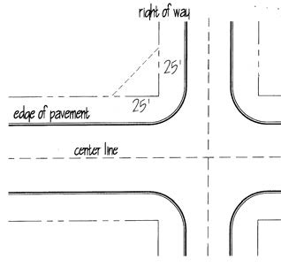
Sight Triangles: On a corner lot in any district, no planting, structure, fence, wall or obstruction to vision more than three feet in height measured from the edge of pavement shall be placed or maintained within the triangular area formed by the intersection of the street lines (right-of-way) and a straight line connecting points on said street lines, each of which is 25 feet distance from the point of intersection. In lieu of the 25' × 25' sight triangle, upon request by the applicant, the Administrator may also, where conditions warrant it, elect to require the standard NCDOT minimum sight triangle for a stop condition of 70 feet (along the existing right of way) and 10 feet (along the new right of way).
Sight triangles are not required in NC, TND, or DMX districts at intersections with all-way stops or traffic signals.
4.
Bulb-outs (also known as curb extensions) to demarcate parking areas and to narrow the street width at intersections may be required on streets 30 feet wide or wider, but are discouraged on narrower streets.
F.
Curb Radii: Curb radii (or corner radius at an intersection) shall be designed according to the street cross-section specifications in Section 9.4 to minimize pedestrian crossing times along all streets requiring sidewalks.
A bulb-out or curb-extension demarcates parking areas and narrows the street width
at intersections. (Image source: R. Drudl)
G.
Storm Drainage in Streets: All streets must be designed as to provide for the discharge of surface water from the right-of-way of all streets. Street drainage facilities shall be designed in accordance with the Town's Standard Specifications and Details.
1.
Storm drainage type should generally be as specified in the Form-Based Standards by Zoning District matrix in Section 2.2. Vertical curb and gutter shall be used when on-street parking is marked, as specified in Section 9.4.
1. Open Swales must have vegetated cover.
2. LID (Low Impact Development) drainage options shall be as specified in the Town's Standard Specifications & Detailsor as approved by the Administrator.
2.
For local streets and cul-de-sacs installed under jurisdiction of these regulations, exception to the requirement for curb and gutter may be allowed for residential lots with a minimum size of 15,000 square feet that meet the criteria as set forth in the Town of Wendell's Standard Specifications & Details and written approval of the Town Engineer.
3.
When vertical curb and gutter is specified, it shall be a minimum of 1.5 feet wide for residential development and 2.5 feet wide for non-residential or mixed-use development. Valley Curb shall be a minimum of two feet wide for all development types.
H.
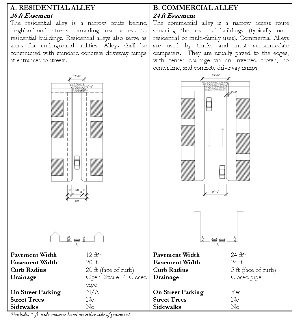
Alleys
1.
Alleys shall be privately owned and maintained as easements or common areas.
2.
Public access easements shall be provided for all alleys and shall be marked as such on all plats.
3.
Alleys shall be constructed with standard concrete driveway ramps at entrances to streets. Driveway standards shall be as specified in the Town's Standard Specifications and Details.
I.
NCDOT Streets: All streets designed for inclusion in the NCDOT system are subject to approval by the Town and by NCDOT.
(Ord. No. O-20-2016, §§ 8, 12—14, 11-14-2016; Ord. No. O-33-2017, § 1, 11-13-2017; Ord. No. O-19-2018, § 1, 1-14-2019)
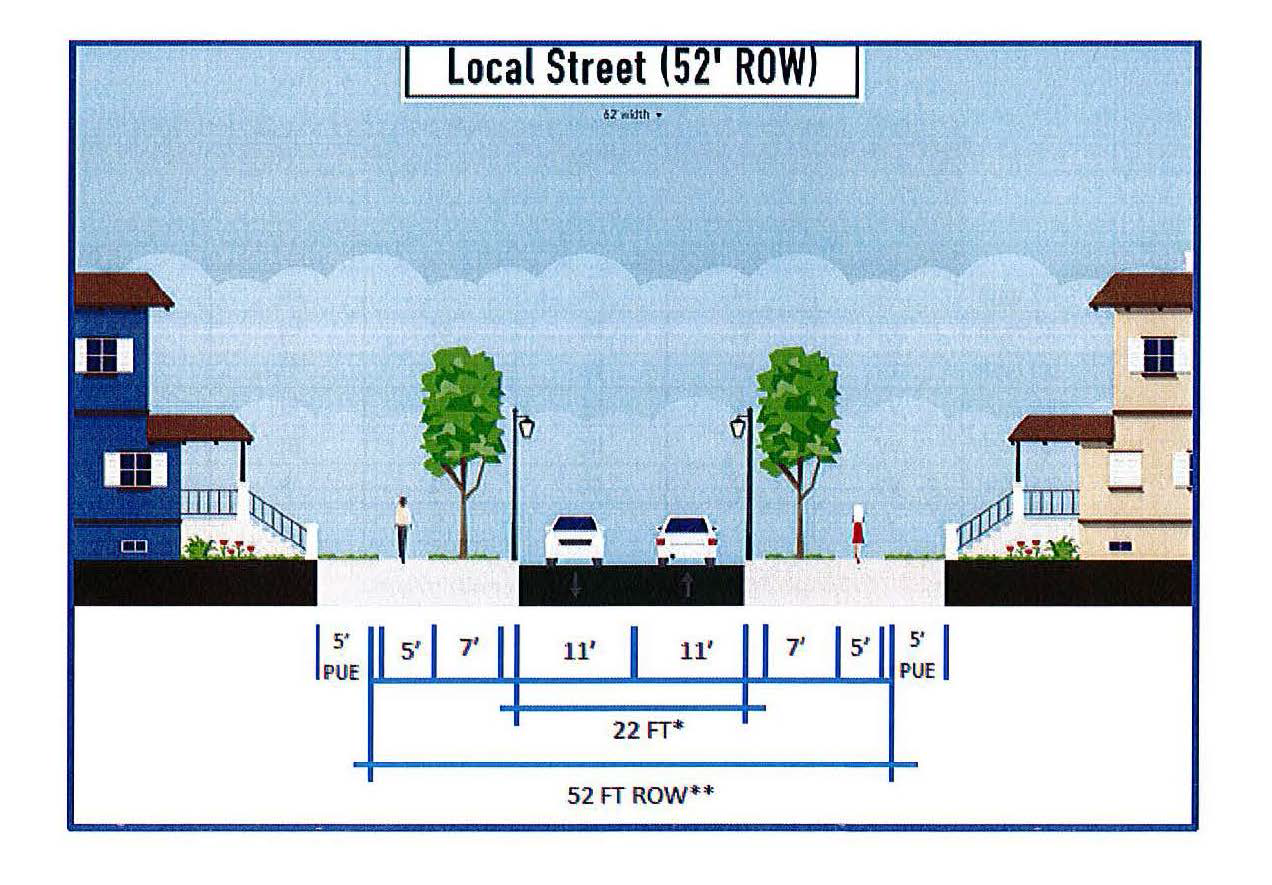
9.4 - Permitted Street Sections
For collector and arterial cross-sections, see Appendix C. The Town permits the use of the following street standards in accordance with the street hierarchy detailed as follows. NCDOT approval may also be required. (Note: All street widths shown are pavement widths only and do not include curb and gutter dimensions except in the case of alleys.)
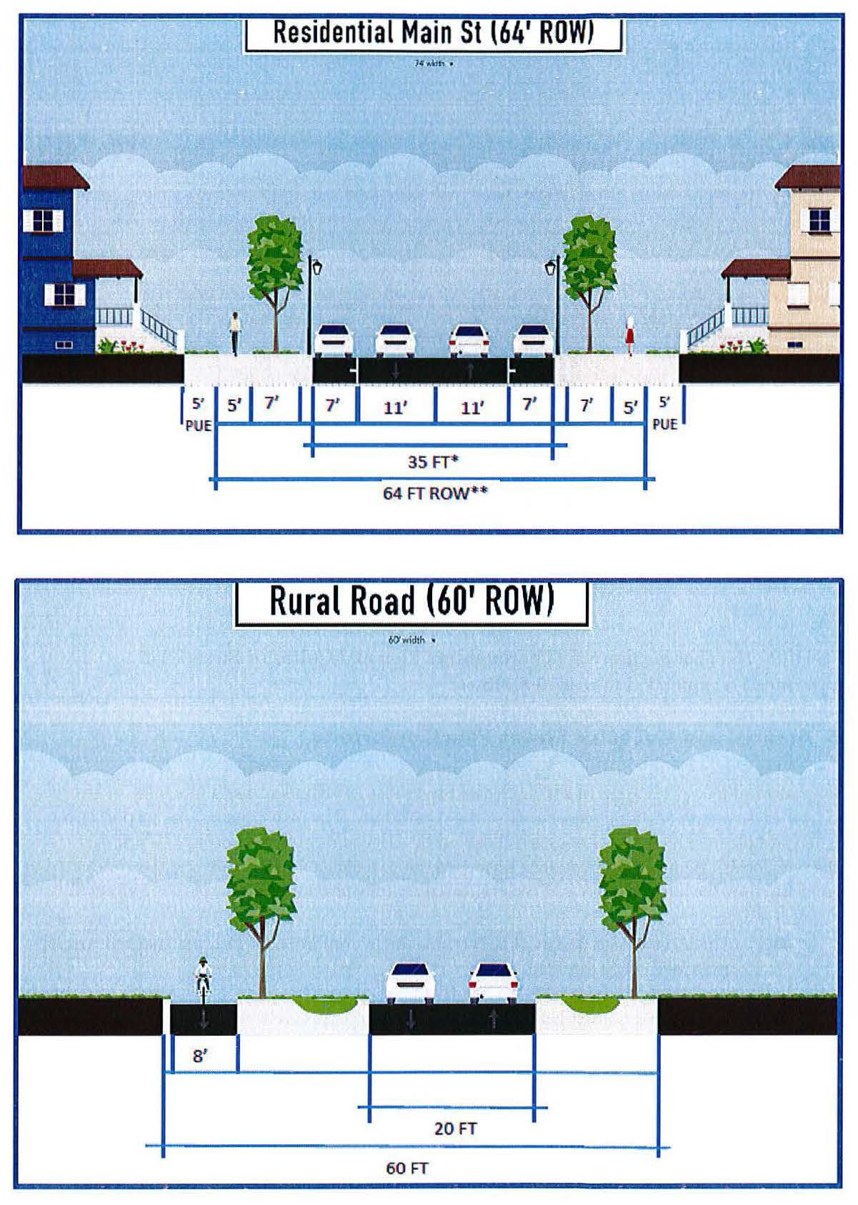
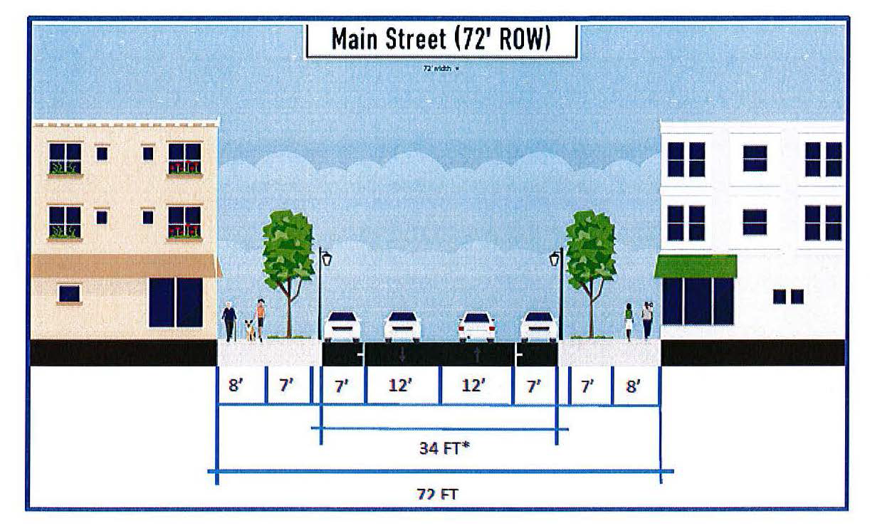
(Ord. No. O-20-2016, § 15, 11-14-2016)
9.5 - Arterial and Collector Street Plan Conformity
This section addresses the Arterial and Collector Street Plan, which identifies a hierarchy of streets and highways to serve the long term needs of the community. The plan consists of a map indicating existing and planned highways. Roads are classified by usage and carrying capacity (i.e., arterials, collectors, locals). As new construction is proposed, more detailed impact study may be conducted to understand how the adjacent streets as well as the entire transportation network will be affected.
A.
The location and design of streets shall be in conformance with the adopted Arterial and Collector Street Plan.
B.
Whenever a tract of land included within any proposed development plan embraces any part of the thoroughfare network as designated on the Arterial and Collector Street Plan [see Appendix C], the Capital Area Metropolitan Planning Organization's [CAMPO] Thoroughfare Plan (also referred to as the Comprehensive Transportation Plan or Metropolitan Transportation Plan), or other adopted Transportation Plan, the development shall be required to dedicate and plat the thoroughfare right-of-way, and shall be responsible for the cost and the installation of the improvements in accordance with the Town's and NCDOT's standards for roadways.
Any existing road which is shown on the Town's Arterial and Collector Street (ACS) Plan as to be improved to an ultimate four-lane divided cross-section shall dedicate the full ROW needed for such improvements, but shall only be required to install a three-lane divided cross-section (unless otherwise required by NCDOT, CAMPO, or per the results of a Transportation Impact Assessment (TIA)). This provision shall not negate any applicable requirements for bicycle or pedestrian improvements to an existing four-lane road. Pedestrian facilities for the three-lane cross-section shall be installed in the correct location for a future four-lane cross-section, unless otherwise permitted by the Administrator.
C.
Developments which embrace only one side of an existing or planned thoroughfare right-of-way will only be required to dedicate and plat additional right-of-way for that portion of roadway on which the development has frontage, and shall be responsible for the cost and the installation of the improvements in accordance with the Town's and NCDOT's standards for roadways.
D.
Dedication of Right-of-Way Abutting Existing Major Thoroughfares.
1.
If a development site abuts an existing major thoroughfare with a right-of-way width less than that recommended in the adopted Arterial and Collector Street Plan (or CAMPO's Thoroughfare Plan), then the development shall include dedication of any additional right-of-way along the development's frontage on the major thoroughfare. The dedication shall include right-of-way sufficient to widen the right-of-way to 45 feet from the centerline of the roadway unless a thoroughfare cross-section has been adopted, in which case the development shall dedicate the amount of right-of-way needed to achieve the proposed cross-section. Thoroughfare cross-sections are included in Appendix C.
E.
Proposed New Thoroughfares.
1.
Incorporation of Thoroughfare: If (i) an adopted Thoroughfare Plan, Collector Street Plan or Transportation Plan proposes a new major thoroughfare across part of a development site; and (ii) an alignment for the thoroughfare has been determined to a reasonable degree of certainty (for example, as a centerline alignment on a functional design plan); and (iii) the thoroughfare could appropriately serve to provide direct access to the development (for example, it would not be a freeway or other restricted-access road), then the development shall incorporate the major thoroughfare into its internal road layout by having one of the development's roads run along the proposed thoroughfare alignment.
2.
Reservation of Future Right-of-Way:
a.
If (i) an adopted Thoroughfare Plan, Collector Street Plan or Transportation Plan proposes a new major thoroughfare—other than one defined in subsection 1 above—across part of a development site; and (ii) an alignment for the thoroughfare has been determined to a reasonable degree of certainty (for example, as a centerline alignment on a functional design plan); and (iii) the Town's development regulations reasonably allow the developer to both realize the maximum lot density allowed by the site's zoning and physical characteristics and avoid developing that part of the site needed as future right-of-way for the proposed thoroughfare, then the development shall include reservation of the thoroughfare's future right-of-way; that is, it shall not include lots or other development within the land area needed as the thoroughfare's future right-of-way.
b.
Land area needed as future right-of-way shall be determined from NCDOT plans where available or other by applying half the right-of-way width recommended in the Arterial and Collector Street Plan (or CAMPO's Thoroughfare Plan) along each side of the thoroughfare's proposed centerline alignment.
3.
Exception to Applicability: If neither provision 1 or provision 2 above applies to a proposed development across which a major thoroughfare is proposed, no incorporation of the major thoroughfare or reservation of future right-of-way for the major thoroughfare shall be required.
4.
Record Plat Notice of Future Right-of-Way: If the Arterial and Collector Street Plan (or CAMPO's Thoroughfare Plan) recommends the widening of an existing major thoroughfare abutting a development site, or proposes a new major thoroughfare across part of a development site, the record plat for the development shall include notice of such. If the land area needed for the planned widening or new thoroughfare can be ascertained with a reasonable degree of certainty, the record plat shall delineate it and label it as future right-of-way.
F.
Collector Street Alignments:
1.
While the Arterial and Collector Street (ACS) Plan depicts existing and future streets, this map is conceptual only and does not reflect the actual location or exact alignment of a proposed facility. Location decisions can only be made after careful consideration and evaluation of a given facility, the specific constraints related to its construction, and proposed land use changes. The map associated with the ACS Plan is intended to identify the general location of future collector streets and the recommended level of connectivity and street spacing.
2.
The street layout in any development shall conform to the arrangement, width and location of collector streets indicated in the adopted ACS Plan. (See Arterial and Collector Street Plan Map, Appendix C). Whenever a tract of land included within any proposed development plan includes any part of the collector street system as designated on the ACS Plan, the development shall be required to dedicate and plat a collector right-of-way, and shall be responsible for the cost and the installation of the improvements in accordance with the Town's standards for roadways. See Chapter 13 for modifications of this improvement requirement for expansions to existing development.
3.
Developments which include only one side of an existing or planned collector street right-of-way will only be required to dedicate and plat the additional right-of-way along the development frontage, if necessary, and shall be responsible for one half of the cost and the installation of the improvements in accordance with the Town's standards for collector streets.
4.
New developments will be required to construct collector streets to the outer perimeter boundaries of the development based on the criteria below.
If the street in question meets at least two of the following criteria, then the street must be built to an appropriate collector street standard.
a.
The street intersects directly with an arterial street and provides access to an area with an overall density of ten dwelling units per acre, or provides access to more than 150 dwelling units.
b.
The street by its general configuration, in relationship to the existing development of the area, in effect serves a collector function.
c.
The street extends into an undeveloped area in such a manner as to serve a future collector function.
d.
The street serves as primary access to a significant nonresidential, institutional, or recreational land, as well as, an access to a residential area of 20 or more acres.
(Ord. No. O-20-2016, § 16, 11-14-2016; Ord. No. O-04-2018, §§ 2, 3, 4-9-2018; Ord. No. O-17-2019, § 1, 8-12-2019)
9.6 - Reserved.
Editor's note— Ord. No. O-20-2016, § 17, adopted Nov. 14, 2016, repealed § 9.6, which pertained to collector street plan. For prior history, see Code Comparative Table.
9.7 - Street Connectivity
Proposed new streets in Wendell shall be extended to the boundary of the development for future connection. Improving connectivity and limiting cul-de-sacs result in improved mobility for motorists, pedestrians, and cyclists; decreased response time for emergency services and delivery costs for services such as garbage collection through improved routing options; and dispersion of motor vehicle traffic.
![A street layout showing a connectivity index of 1.44 ([11 links + 2 connections]/9 nodes). Links are shown as circles and nodes are shown as stars and connections to existing streets are shown as C's.](https://mcclibrary.blob.core.usgovcloudapi.net/codecontent/14255/427331/UDO9.7_1.png)
A street layout showing a connectivity index of 1.44 ([11 links + 2 connections]/9
nodes). Links are shown as circles and nodes are shown as stars and connections to
existing streets are shown as C's.
A Connectivity Index shall be used to determine the adequacy of street connectivity in new developments. The index is calculated as the ratio of the number of street links in a project's street layout (road sections between intersections or stubs to adjacent property) plus connections to existing streets divided by the number of street nodes (intersections and cul-de-sac heads).
Connectivity Index =
(links + connections)/nodes
The illustration at right above illustrates a connectivity index of 1.44 (links are shown as circles, nodes are shown as stars, and connections to existing streets are shown as C's). The illustration has 11 links, two connections, and nine nodes for an index of (11+2)/9=1.44. In the illustration at right below, one cul-de-sac is converted to a full intersection. This gives the development one additional link for a connectivity index of 1.55 ([12 links + 2 connections]/9 nodes). The same number of lots is shown in both illustrations.
![A street layout showing a connectivity index of 1.55 ([12 links + 2 connections]/9 nodes). Note that one cul-de-sac from the original layout has been converted to a full intersection. The same number of lots are shown.](https://mcclibrary.blob.core.usgovcloudapi.net/codecontent/14255/427331/UDO9.7_2.png)
A street layout showing a connectivity index of 1.55 ([12 links + 2 connections]/9
nodes). Note that one cul-de-sac from the original layout has been converted to a
full intersection. The same number of lots are shown.
A.
Connectivity Index Requirement
1.
Developments shall be required to achieve a connectivity index as shown in the following table.
2.
Variations in the connectivity requirement may be considered on a case-by-case basis by the Administrator based on the factors that follow. The Administrator may award a connectivity index bonus if it is determined that more than 60 percent of any "side" of a development (four sides total) faces impracticalities for connectivity to adjacent properties due to the presence of controlled-access highways, railroad rights-of-way, stream buffers, topographical conditions (pre-development slopes of 25 percent or greater) or existing developments that have not provided street stub-outs for connection purposes.
B.
Street Layout: The street layout in any development shall conform to the arrangement, width and location of public streets indicated on the regulating Thoroughfare Plan and Collector Street Plan for the area. Streets not indicated on that plan shall be designed and located to:
1.
Connect to existing and proposed streets in adjacent developments wherever possible as determined by the Administrator;
2.
Relate to the topography;
3.
Preserve natural features such as streams and tree growth;
4.
Provide for adequate public safety and convenience.
5.
Where land is subdivided into larger parcels than ordinary building lots, such parcels shall be so arranged as to allow for the opening of future streets and logical further resubdivision.
C.
Block Length
1.
On one-way local streets (see cross-section 9.4.D), where on-street parking is allowed, blocks shall be no longer than 300 feet or they shall provide at least every 200 feet areas of 40 feet in length where no parking is allowed. These areas are to be used for emergency access staging.
2.
Pedestrian Path: Blocks longer than 800 feet may be required to include a pedestrian pathway across the center of the long side of the block. The path shall have at least a 20-foot easement with a minimum six-foot wide pathway.
3.
Exceptions: OSC, RA and M&I Districts are exempt from the block length provisions of this subsection.
D.
Required Stubs
1.
New developments shall connect to any existing street stubs from adjacent properties.
2.
The number of required street stubs to adjacent property is determined by calculating the cumulative linear feet of all property lines surrounding the proposed development contiguous with land that is suitable for development or redevelopment (as determined by the Administrator or an adopted land use plan); dividing by 1,200; and rounding up to the nearest whole number.
Example (see diagram below):
675' + 750' + 950' + 985' = 3160' /1200 = 2.63 = 3 required stubs
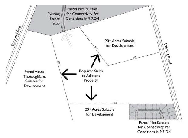
3.
The location of new required stub street shall be prioritized as follows:
a.
Adjacent parcels 20 acres or greater.
b.
Adjacent parcels that abut or are traversed by existing or proposed thoroughfares or collector streets.
c.
Where any adopted transportation or land use plan recommends a street connection.
d.
Landlocked properties.
4.
Where the conditions listed in Section 9.7.E, Cul-de-Sacs (below) would prevent connections, the adjacent property shall not be included in the calculation of required stubs.
5.
Stub streets and streets intended for extension during future phases shall be constructed to extend to the property line or as close to the line as practical. It shall be the responsibility of the second development to construct the connection to an existing stub street. Stub (or dead head) streets shall not exceed 150 feet in length without a paved turnaround (permanent or temporary).
E.
Cul-de-Sacs
1.
Cul-de-sacs shall not be used to avoid connection with an existing street, to avoid the extension of a thoroughfare or collector street, or to avoid connection to adjoining property. In general, cul-de-sacs shall not be used to provide access to development on the boundary of the development.
2.
Cul-de-sacs are permitted where one or more of the following conditions offer no practical alternative for connectivity:
a.
Topographical conditions (where pre-development slopes are 25 percent or greater)
b.
Environmental conditions
c.
Property shape
d.
Property accessibility
e.
Land use relationships
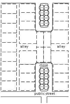
Close—an alternative to cul-de-sacs
3.
Where practical, a close should be used in place of a cul-de-sac.
4.
Any permanent dead-end streets or cul-de-sac shall comply with the length limits shown in the following table.
Measurement shall be from the point where the centerline of the cul-de-sac street intersects with the centerline of the general circulation street to the center of the turnaround of the cul-de-sac.
5.
Where cul-de-sacs or dead end streets are unavoidable, developments shall incorporate provisions for pedestrian and bicycle connections to adjacent properties.
6.
No system of multiple branching cul-de-sacs from a single access point is permitted.
9.8 - Intersections
A.
Streets shall be designed so as to intersect as nearly as possible at right angles.
B.
No street shall intersect any other street at an angle of less than 60 degrees.
C.
Streets crossing natural areas or streams shall cross at or as near to right angles as possible within limits of topographic conditions. Crossing of "blue line" channels shown on the current USGS Quad Map or USDA Soil Survey Map shall also be approved by the North Carolina Division of Water Quality.
D.
Offset intersections are to be avoided.
E.
Intersection Spacing:
1.
Intersections with major thoroughfares shall be at least 800 feet apart (measured from centerline to centerline) where posted speeds are more than 35 mph; or as specified by NCDOT.
2.
On major thoroughfares where posted speeds are 35 mph or less, intersections shall be spaced at least 400 feet.
3.
On all other streets, a minimum intersection spacing of 200 feet shall be maintained for all other streets.
9.9 - Access Management
Access management standards seek to preserve the traffic moving capacity of the Town's major streets, and in so doing, protect the investment of the taxpayer in the costs of road construction. The Town does not wish to allow unnecessary driveway cuts to neutralize the value of road construction dollars provided by Federal, State and local taxpayers. Frequent driveways allow for unpredictable stops and vehicle turning movements, causing increased congestion, and greater opportunities for traffic accidents.
Developments should minimize or eliminate curb cuts along arterials. Where possible, vehicular access should be shared with the adjacent properties and/or alleys or should be utilized for access. All non-residential lots, parcels, or any other division of land adjacent to an arterial roadway may be allowed driveways or street connections in accordance with the tables below.
A.
Driveway Number and Spacing (thoroughfares only)
B.
Driveway Distance from Intersections: Location guidelines for driveway access points along arterials are shown in the table below. If access to a lot, parcel, or any other lawful division of land is physically unobtainable under the provisions below, driveway access points are to be located the greatest distance possible from one another and from other public and private streets.
C.
Median Opening Spacing: Crossovers along median divided thoroughfares should be spaced no closer than 1,200 feet. For all other streets, the spacing should be no closer than 660 feet. In general, if the left turn lane storage requirements for adjacent intersections overlap, the minimum spacing shall be increased to provide adequate left turn lane storage in both directions.
Where the NC DOT Driveway Manual or Median Crossover Guide conflicts, the stricter of the two standards should prevail.
9.10 - Transportation Impact Analysis
The Transportation Impact Analysis (TIA) is a specialized study that evaluates the effects of a development's traffic on the surrounding transportation infrastructure. It is an essential part of the development review process to assist developers and government agencies in making land use decisions involving annexations, subdivisions, rezonings, special land uses, and other development reviews. The TIA helps identify where the development may have a significant impact on safety, traffic and transportation operations, and provides a means for the developer and government agencies to mitigate these impacts. Ultimately, the TIA can be used to evaluate whether the scale of development is appropriate for a particular site and what improvements may be necessary, on and off the site, to provide safe and efficient access and traffic flow.
A.
A TIA shall be required for a rezoning, conditional district, subdivision plan, site plan, special use permit, certificate of zoning compliance, or preliminary plat for developments and/or their subsequent phases with an estimated trip generation of 100 peak hour trips per day or greater during an average weekday based on a five-day national average as defined in the ITE Trip Generation Manual. At the discretion of the Planning Director, a TIA may be required for projects generating 75 or more peak hour trips, based on case specific determining factors.
B.
A traffic impact analysis report shall address the impact of projected horizon year (two years after build-out by phase or entire development as appropriate) traffic volumes. It shall identify the methodology used to evaluate the impact. The weekday peak hour impact shall be evaluated as well as the Saturday peak hour for those uses exhibiting high levels of weekend traffic generation.
C.
Based on the findings of the analysis, if a proposed development does not meet the applicable service level standards, the applicant shall be required to upgrade the facilities in accordance with the adopted level of service program. Mitigation measures may involve strategies other than roadway construction or other physical improvements such as changes to traffic signal timing or phasing, and transportation management strategies.
D.
Thresholds for Mitigation: The Town requires consideration of roadway and/or operational improvements when the proposed development increases the intersection Volume-to-Capacity Ratio (V/C) beyond the thresholds indicated in the table below. The Town evaluates the impacts of proposed development at intersections (primarily under existing year conditions) based on the increase in V/C ratio as a result of the projected site traffic. This increase is determined by comparing the V/C ratio under existing development conditions and proposed development conditions. For the purposes of this comparison, all non-signalized intersections are analyzed as signalized intersections.
E.
A TIA will vary in range and complexity depending on the type and size of the proposed development. The procedures for a TIA are part of the Major Site Plan Review as noted in Section 15.6.B. The TIA requirements as described in Section 16.11 may be modified by the Administrator.
(Ord. No. O-20-2016, § 18, 11-14-2016; Ord. No. O-17-2019, §§ 2, 3, 8-12-2019)