
Apple Valley City Zoning Code
CHAPTER 9
28 - Residential Districts
9.28.010 - Purpose and General Plan Consistency
A.
Purpose. The residential districts as well as the regulation of uses and basic site and improvement standards contained in this Chapter implement the Town General Plan by achieving the following purposes:
1.
To implement General Plan goals and policies to promote safe, attractive and well-served residential areas.
2.
To reserve areas for residential uses for family living at a broad range of dwelling unit densities consistent with the General Plan and appropriate standards of public health, safety and welfare;
3.
To define specific uses for residential districts which implement the range of uses identified in the General Plan;
4.
To establish basic site development and improvement standards consistent with applicable General Plan policies to insure compatibility among new and existing residential districts and to minimize the potential for incompatible uses to adversely affect one another;
5.
To develop drainage solution and to avoid exacerbation of any existing flooding problem;
6.
To minimize traffic congestion and to avoid the overloading of public services and utilities;
7.
To facilitate the efficient provision of public services and other public facilities consistent with the General Plan and with anticipated population, dwelling unit densities and service requirements;
8.
To establish open areas and to provide multi-use trail linkages to capitalize on existing facilities and avoid the loss of opportunities available during the planning and design of residential projects;
9.
To maintain a minimum lot size throughout the Town of 18,000 net square feet per new parcel unless a specific plan or planned unit development is submitted for consideration;
10.
To create a clear and consistent set of standards to assist the development community in comprehending applicable General Plan policies and the Town's intent with regard to regulating residential development, and
11.
To establish zoning for lands surrounding the Town, both within and outside its sphere of influence, which establishes Town zoning districts for these lands, if they are annexed to the Town in the future.
9.28.020 - Residential Districts (Amended Ord. 383)
A.
Very Low Density Residential (R-VLD). This district is intended for very low density, single family detached housing development with a minimum lot size of five (5) gross acres per unit. This area is suited for agriculture, animal keeping and equestrian uses, but because of environmental constraints or lack of services these uses must occur at low intensities. This zoning district implements the General Plan Very Low Density Residential (R-VLD) land use designation density of five (5) or more gross acres per dwelling unit. For zoned lands outside the Town limits, suffixes have been applied which denote the minimum acreage required in the zone.
B.
Residential Agriculture (R-A). This district is intended to provide the continued operation of those agricultural uses in areas previously zoned for agricultural by the County in the vicinity of the Deep Creek area. Minimum lot size shall be two and one-half (2.5) gross acres per dwelling unit. Single family residential and commercial agricultural uses will be allowed subject to the standards provided in this Development Code. This zoning district implements the General Plan Low Density Residential (R-LD) land use designation density of two and one-half (2.5) to five (5) gross acres per dwelling unit.
C.
Low Density Residential (R-LD). This district is intended to ensure that the open character of certain areas of the Town is maintained even with new single family residential development. Minimum lot sizes may range from two and one-half (2.5) to five (5) gross acres per dwelling unit, depending on environmental conditions, infrastructure and adjacent land uses. Low Density Residential districts may include environmentally constrained (i.e., floodplain, seismic areas, topography, endangered species habitat, etc.) areas or areas which lack infrastructure necessary for urbanization. Certain types of agriculture, animal keeping, and equestrian uses may also be allowed in this district, subject to the standards provided in this Development Code. This district shall serve as the holding zone for the Community Reserve (R-C) land use areas designated in the General Plan.
D.
Estate Residential (R-E). This district is designed to provide for single family residential subdivisions with a rural atmosphere and the opportunity for custom homes which will allow equestrian uses and animal keeping. These areas must be served by infrastructure and utilities. Minimum lot size shall be one (1.0) gross acre. This district implements the General Plan Estate Residential (R-E) land use designation density of one (1.0) to two and one-half (2.5) gross acres per dwelling unit.
E.
Estate Residential 3/4 (R-E 3/4). This district is designed to provide for single family residential subdivisions with a rural atmosphere and an emphasis on equestrian uses and animal keeping. Minimum lot size shall be three quarters of a net acre (0.75 acres, or 32,670 square feet). Actual lot size will be determined by site specific conditions such as natural features, infrastructure and the need to provide buffers to adjacent land uses. This district implements the General Plan Estate Residential 3/4 (R-E 3/4land use designation, with a density of one unit per three quarters of an acre net (0.75) to one (1) acre net.
F.
Equestrian Residential (R-EQ). This district is intended for residential subdivisions of single family detached residences served by adequate infrastructure and services which will be somewhat rural in character. Equestrian uses and animal keeping will be allowed subject to the provisions of this Code. This district implements the Equestrian Neighborhoods Map contained in the Town General Plan (General Plan Figure LU-4). Minimum lot size shall be 0.4 net acres (18,000 square feet). Actual lot size will be determined by site specific conditions such as natural features, infrastructure and the need to provide buffers to adjacent land uses. This zoning district implements the General Plan Single Family Residential (R-SF) and Equestrian Neighborhoods land use designations with a density range of 0.4 to 0.9 dwelling units per acre.
G.
Single Family Residential (R-SF). This district is intended to provide for residential subdivisions of single family detached residences in areas served by adequate infrastructure and services. The dominant use of these areas is residential. Only limited animal keeping will be allowed. Minimum lot size shall be 0.4 net acres (18,000 square feet), except within the Mountain Vista neighborhood where existing smaller lots of 0.2 net acres (10,000 square feet) are allowed. Actual lot size will be determined by site specific conditions such as natural features, infrastructure and the need to provide buffers to adjacent land uses. This zoning district implements the General Plan Single Family Residential (R-SF) land use designation with a density range of 0.4 to 0.9 dwelling units per acre.
H.
Multi-Family Residential (R-M). This district is intended to provide an area for higher density housing types, including single family attached and multi-family homes such as duplexes, condominiums, townhouses, apartments and senior housing developments. Single family detached units are allowed on existing lots of 0.2 net acres (10,000 square feet) in the Mountain Vista neighborhood only [2]. Up to twenty (20) units per acre may be allowed. The minimum lot size shall be 0.4 net acres (18,000 square feet), except for existing lots of no less than 0.2 net acres in the Mountain Vista neighborhood. The maximum number of units allowed on a parcel located in the R-M district shall be calculated by multiplying the total net area of the lot in acres by twenty (20) units per acre.
I.
Mobile Home Park (MHP). This district applies to mobile home parks that existed upon completion of the General Plan. New mobile home parks will require a change of zone to assign this designation to a project. This designation allows for a density range of five (5) to fifteen (15) dwelling units per net acre.
J.
Mixed Use (M-U). Lands designated for mixed use must contain residential development along with commercial and/or office development in an integrated, master planned project. Residential densities range from four (4) to thirty (30) units per acre.
K.
Planned Residential Development (PRD). The Planned Residential Development district is intended to provide an opportunity for greater flexibility in development standards and, consequently, more creative and imaginative designs for the development of specific areas than is possible under the prescribed standards of the designated district. The Planned Residential Development district may be approved in any area designated for residential use in the General Plan through the Planned Development Permit process. The density within the PRD must be consistent with the density prescribed in the General Plan unless a specific plan consistent with the General Plan is adopted.
The Mountain Vista neighborhood shall be defined as the Medium Density Residential lands located east of and adjacent to Rancherias Road, south of and fronting Otoe Road, north of and fronting Thunderbird Road, and west of and fronting Sago and Wanaque Roads.
9.28.030 - Permitted Uses (Amended Ord. 259, 263, 264, 288, 309, 314, 315, 316, 323, 340, 350, 376, 383, 401, 412, 432, 454)
If a proposed use is not listed in this Section, the Director shall, upon written request and in accordance with Section 9.05.070Similar Uses, of this Code, review the proposed unlisted use. Based on the characteristics of the proposed use, the Standard Industrial Classification Manual and other available resources, the Director may determine that the proposed unlisted use is equivalent in nature and intensity to a listed use. The proposed use shall then be treated in the same manner as the equivalent listed use in determining where it can be located, what permits are required and what standards affect its establishment if the findings required in Section 9.05.070Similar Uses, of this Code, can be made.
ABBREVIATIONS
The Conditional and Special Use Permit and processes are detailed in Chapter 9.16 and the Development Permit process is detailed in Chapter 9.17 of this Code.
The uses listed in Table 9.28.030-A below apply to applications for expansion, tenant improvements, change of occupancy or new development.
Table 9.28.030-A Permitted Uses
(Ord. No. 482, § 3, 2-9-2016; Ord. No. 502, § 4, 5-8-2018; Ord. No. 544, §§ 17, 18, 3-23-2021; Ord. No. 561, § 3, 2-14-2023)
* Permitted only in the Mountain Vista neighborhood. See Section 9.28.020H, Footnote 1
9.28.040 - Site Development Standards (Amended Ord. 314, 341, 354)
The Site Development Standards in Table 9.28.040-A are intended to provide standards for the development and use of land within the residential districts. These standards apply in conjunction with the applicable specific use regulations in Chapter 9.29, and the design standards in Chapter 9.31. All submissions to the Town of Apple Valley for a development or other permit, whether for Planning Commission, Town Council, or Plan Check and Building Permit review, may be required to provide public right-of-way or other appropriate dedication(s) and off-site and/or street and other related public improvement(s) consistent with the Circulation Element of the adopted General Plan and/or applicable standards established by the Town Engineer, as determined by the Town of Apple Valley Town Engineer, to mitigate and/or contribute toward mitigation of impacts, to promote the public health, safety and welfare, and as not otherwise restricted by law.
The setbacks specified in Table 9.28.040-A shall be the setback standards, except for the Mountain Vista neighborhood, as defined in this Chapter, and for which setbacks are specified in Table 9.28.040-C, or unless a different setback is indicated by a Ranchos Residential Overlay District as designated in Chapter 9.63 of this Code or is required as delineated on all Final Maps, Parcel Maps and Records of Survey Maps recorded in San Bernardino County between March 1, 1948, and January 1, 1987, or on Composite Development Plans on file in Town offices; then these setbacks shall be the street and yard setback distances required on the property within said Final Maps, Parcel Maps, Records of Survey or Composite Development Plan. Notwithstanding any other provision of this Code, any request to modify or deviate from a building setback line designated on a recorded map or final map shall be made in accordance with the provisions of Chapter 9.24 Variances or Chapter 9.25 Deviation Permits, of this Code.
Table 9.28.040-A Site Development Standards
(1) Development standards shall comply with the minimums established in this Chapter, and in Section 9.29.080, Planned Residential Developments, of this Code, and shall be consistent with an approved Planned Development Permit. Development standards not addressed in an approved PRD shall be the same as those standards contained in this Code for the most similar use or situation.
(2) Lot area measured in gross acres.
(3) Lot area measured in net square feet.
(4) Density shall be consistent with the General Plan and applicable sections of the Development Code.
(5) A minimum driveway of twenty (20) feet is required for the entrance to a garage or carport unless an automatic garage door opener is provided or unless garage access is provided from an alley.
(6) Reduced rear setbacks are allowed for accessory structures pursuant to Section 9.29.030.B.
(7) The Ranchos Residential Overlay District(s), Chapter 9.63 of this Code, may specify different side yard setbacks for interior lot lines.
(8) Ten (10) feet is required on one side setback, fifteen (15) feet on the opposite side. See also Section 9.28.140, Solar Access, of this Code; subject to solar access requirements. A minimum fifteen (15) foot setback is required between residential districts and other districts.
(9) Solid fences in excess of four (4) feet in height are not allowed closer than twelve (12) feet to the right-of-way, pursuant to the provisions of Section 9.28.120 Fences, Walls and Hedges, of this Chapter.
(10) In addition, a sixty-five (65) foot setback from roofed animal enclosures to habitable structure setbacks on adjacent property is required by paragraph 9.29.030.C.2 of this Code.
(11) Certain mechanical and architectural features may exceed height limits by a maximum of fifteen (15) feet pursuant to subsection 9.28.040.E Projections above Height Limits, of this Chapter.
(12) See Subsection 9.29.070.B General Development, of this Code.
(13) See subsections 9.29.070.C.9, 9.29.070.D.9, and 9.29.070.E.7, of this Code.
(14) See subsection 9.29.070.B.6 Lot Coverage, of this Code.
(15) For lands located outside the Town limits, the following minimum lot sizes shall
apply (see Zoning Map).
R-VLD/10 10 acre minimum lot size
R-VLD/20 20 acre minimum lot size
R-VLD/40 40 acre minimum lot size
(16) From Major or Secondary/Local Streets
(17) Projects proposed in the Deep Creek area shall be required to provide buffers along its perimeter, such as open space, large parkways, and equestrian trails, or perimeter lots of the same size or larger than the adjacent land use designation, or lands across the abutting street to minimize impacts to existing neighborhoods. The Deep Creek area shall be defined as land south of Bear Valley Road, east of the Jess Ranch Specific Plan, north of Tussing Ranch Road, and west of Itoya Vista Road and Mockingbird Avenue.
(18) See Table 9.28.040.E and Section 9.28.040.B for permitted projections and exceptions to the required setbacks.
Consistent with the General Plan, the following site development standards are applied to the Mountain Vista neighborhood. The Mountain Vista neighborhood shall be defined as the Medium Density Residential lands located east of and adjacent to Rancherias Road, south of and fronting Otoe Road, north of and fronting Thunderbird Road, and west of and fronting Sago and Wanaque Roads. The following standards apply to lots created after the adoption of this Section (April 27, 2010). Existing lots as of the adoption of this Section shall comply with the standards of the R-M zone.
Table 9.28.040-C Site Development Standards for the
Mountain Vista Neighborhood(1)
(1) Development standards shall comply with the minimums established in this Chapter, and in Section 9.29.080, Planned Residential Developments, of this Code, and shall be consistent with an approved Planned Development Permit. Development standards not addressed in an approved PRD shall be the same as those standards contained in this Code for the most similar use or situation.
(2) Lot area measured in net square feet.
(3) Density shall be consistent with the General Plan and applicable sections of the Development Code.
(4) Reduced rear setbacks are allowed for accessory structures pursuant to Section 9.29.030.B.
(5) No portion of the building shall be less than ten (10) feet from the side lines of the lot. Ten (10) feet is required on one side setback, fifteen (15) feet on the opposite side. See also Section 9.28.140, Solar Access, of this Code; subject to solar access requirements. A minimum fifteen (15) foot setback is required between residential districts and other districts. Non-habitable structures can encroach within the side and rear yard setbacks. See subsection 9.29.070.B.2 and 3.
(6) Solid fences in excess of four (4) feet in height are not allowed closer than twelve (12) feet to the right-of-way, pursuant to the provisions of Section 9.28.120 Fences, Walls and Hedges, of this Chapter.
(7) Certain mechanical and architectural features may exceed height limits by a maximum of fifteen (15) feet pursuant to subsection 9.28.040.E Projections above Height Limits, of this Chapter.
(8) See subsections 9.29.070.C.9, 9.29.070.D.9, and 9.29.070.E.7, of this Code.
(9) See subsection 9.29.070.B.6 Lot Coverage, of this Code.
(10) See Subsection 9.29.070.B General Development, of this Code.
(11) Handicapped access ramps are permitted in the front, side and rear setbacks.
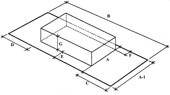
Figure 9.28.040-A Building Envelope
A.
Projections into Yards.
Table 9.28.040-C summarizes the various projections that are permitted into the required setbacks in the residential districts.
Table 9.28.040-E Projections Into Yards
B.
Exceptions to Required Structure Setbacks
1.
All Setbacks
a.
Dedications of right-of-way. A variance to required setbacks shall not be required for a new single-family dwelling on an existing lot of record which is reduced in size to less than the minimum site area required in the applicable zone district due to requirements for a public dedication of right-of-way. The required setback on those lots affected by the dedication may be reduced by the amount of dedication required, except that the front yard setback or the setback to a garage shall not be less than twenty (20) feet and the street side setback shall not be less than fifteen (15) feet unless a Variance is obtained.
2.
Reduction for Solar Access
a.
Side and rear setbacks. In cases where it is not possible to orient a new single-family dwelling southward within the applicable side setback requirements for the purpose of incorporating an active or passive solar energy system, a fifty (50) percent reduction in the side or rear setback requirements may be authorized through the Conditional Use Permit approval process, provided that:
1)
The reduced setback will not restrict emergency access or present a fire hazard;
2)
The reduced setback will not be detrimental or injurious to property or improvements in the neighborhood, and will not limit solar energy access on neighboring property to a greater extent than if the building envelope complied with the required setbacks;
3)
The portion of the building or structural improvements proposed within the required setback is designed for the primary purpose of collecting solar energy;
4)
The solar equipment shall be no taller than eight (8) feet in height.
3.
Accessory Structures
a.
Accessory structures no larger than one hundred twenty (120) square feet and not exceeding eight (8) feet in height may be located within five (5) feet of a side or rear property line provided no part of the accessory structure is located within the required front yard.
b.
Swimming pools may be located no closer than five (5) feet to a side or rear property line.
c.
Ground mounted air conditioners, swimming pool pumps, heaters, filters and fans may be located in a required side or rear yard provided that such structures or equipment are not closer than five (5) feet to any property line, and that such structures or equipment do not exceed a height of six (6) feet measured from the base of the unit. Such equipment shall be screened from adjacent property or street by a solid fence or wall.
4.
A porte cochere may project into 50 (fifty) percent of the required front setback but not less than 25 (twenty-five) feet from the front property line.
5.
Exceptions to required setbacks for the keeping of animals may be reviewed under Section 9.25, Deviation Permit, of this Code.
6.
Handicapped access ramps are permitted in the front, side and rear setbacks.
C.
Front Setback Averaging. The front setbacks of dwellings along a block shall be averaged in order to break up a solid line of building facades down a street and create visual interest.
1.
New Subdivisions. Adjacent homes shall have varied setbacks. The setback offset shall be a minimum of five (5) feet (Figure 9.28.040-B and C).
Figure 9.28.040-B Varied Setbacks
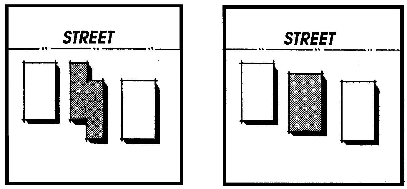
Figure 9.28.040-C
D.
Street Side Setbacks. Street setbacks shall be measured from the design right-of-way required by the Master Circulation Plan of the General Plan or; if the street is proposed to be private or is now a private street, the maximum required street width.
E.
Projections Above Height Limits
1.
Flues, chimneys, elevators or other mechanical equipment, television antennas, similar utility or mechanical features, but not including flag poles, may exceed the height limits established in Table 9.28.040-A by a maximum of fifteen (15) feet. All roof mounted equipment shall be screened as required in Chapter 9.31, Residential Design Standards, of this Code.
2.
Architectural features such as cupolas, belltowers, and steeples may exceed the height limits by a maximum of fifteen (15) feet when approved by the Planning Commission. The Commission must find that any such projection which exceeds the height limits is an integral part of the building and will enhance the overall design of the building(s).
F.
Sidewalk, Curb and Gutter
1.
Rolled curbs are permitted for new projects on local roads within the Residential Very Low Density (R-VLD), Residential Low Density (R-LD) Zoning Districts, Rolled curbs are permitted in Residential Estate (RE) and Residential Estate ¾ (RE ¾) Zoning Districts. Sidewalks are not required in these zoning districts.
(Ord. No. 491, § 4, 2-14-2017; Ord. No. 544, §§ 5—10, 3-23-2021; Ord. No. 567, §§ 3, 4, 12-12-2023)
9.28.050 - Subdivision Design Standards (Amended Ord. 300, 317, 343, 354)
The following standards are provided to facilitate the preparation of subdivision maps by locating the residential standards from the Development Code most pertinent to subdivisions in one section. Any development in a residential district must therefore also be consistent with all other applicable requirements of this Code.
A.
Site Evaluation. The site and surrounding area should be analyzed to identify hazardous or undevelopable areas, drainage channels, environmentally sensitive areas, and open space resources as designated in the General Plan. Adjacent development shall be considered when determining the type of buffering or screening to be required.
B.
Minimize Site Preparation Requirements. Buildings and roads should be integrated into the natural pattern of the landscape. Clearing and grading shall generally be limited to areas for those areas to be built on (roads and structures). Except for roadways, drainage and activities required to extend infrastructure, land disturbance should be limited to thirty (30) feet surrounding a building pad.
C.
Drainage Facilities. Storm drainage facilities shall be planned as an integral part of the subdivision with systems designed to minimize the possibility of soil erosion, siltation and flooding.
D.
Access and Circulation
1.
Streets shall be designed to minimize disruption of the physical characteristics of the site such as topography, grade and drainage. Generally, streets shall follow the natural contours of the site.
2.
Every residential lot shall have access from a dedicated local street right-of-way. Access shall be from a residential local street wherever possible. Subdivisions shall be designed orienting and providing access for lots toward existing local streets rather than creating through lots.
3.
Access to residential lots from major or secondary roads is not permitted unless no reasonable alternative exists. Major and secondary roads are designated in the Circulation Element of the General Plan.
4.
Local streets in subdivisions shall be arranged to minimize through traffic in residential neighborhoods. An indirect street pattern and use of curved streets, cul-de-sacs, and loop streets shall be used to reduce traffic speeds and create neighborhood enclaves.
5.
Residential collector streets through neighborhoods shall be minimized to reduce noise and traffic created by through traffic and to discourage use of residential collector streets used as shortcuts between higher order streets.
6.
The number of intersections with major roads shall be minimized to maintain optimum traffic conditions on major roads.
7.
All intersections shall meet at approximately ninety (90) degree angles. Streets which intersect at acute angles (less than 80 degrees) are not permitted. Curved street approaches to achieve ninety (90) degree intersections are preferable to angled intersections.
8.
If the centerline of two streets (or major driveways for multi-family projects) intercept the same street from opposite directions are offset from each other, the offset shall be a minimum of 125 feet on local and collector streets and 200 feet on arterial streets, measured along the street intercepted.
9.
Residential access streets shall be designed to carry a maximum Average Daily Traffic (ADT) of 250, approximately twenty-five (25) single family residences. Subdivision access street volumes shall not exceed an ADT of 500, approximately fifty (50) single family residences, as shown in Figure 9.28.050-A.
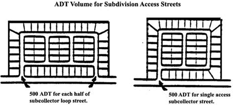
Figure 9.28.050-A Average Daily Traffic
10.
Cul-de-sac lengths shall not exceed the lesser of the length of twelve (12) single-family residences on one side or 1,000 feet, measured from the centerline of the intersecting street to the center of the turn-around, and shall be approved by the Apple Valley Fire District and the Engineering Division. A minimum radius of forty-seven (47) feet shall be required for cul-de-sac turnarounds.
E.
Required Landscaping
1.
The parkway area located within the right-of-way of major and secondary roads, as designated on the Town of Apple Valley Major and Secondary Right-of-Way Standards that abut a subdivision shall be landscaped and permanently maintained.
2.
In addition to the parkway area, a fourteen (14)- and sixteen (16)-foot wide easement parallel to the parkways of Major and Secondary roads, respectively, shall be provided to allow for landscaping, bicycle paths and multi-use trails and also provide greater flexibility in streetscape landscape designs and to avoid a tunnel effect created by unbroken soundwalls placed too close to these streets.
3.
The landscaping located along the parkway and easement area shall be installed and permanently maintained in accordance with the applicable provisions of this Code.
F.
Minimum Parcel Requirements/General
1.
All lots shall provide sufficient developable area to allow residential construction meeting all of the requirements of this Code. No parcel shall be divided so as to reduce the building site area, width, depth or frontage below those required in Table 9.28.040-A and this Chapter, except as provided in subsection 9.28.050.F.4 below. In addition to the standards contained in Table 9.28.040-A, minimum parcel size shall also be based upon applicable policies of the General Plan and applicable regulations of this Code. For projects proposed in the Deep Creek Area, as defined in Table 9.28.040-A Footnote 1, perimeter lots are required to be of the same size or larger than the adjacent land use designation, or lands across the abutting street.
2.
No yard or other open space providing the required open space or yard setbacks for any building on one site shall be considered as providing yard or open space requirements for a building on any other site.
3.
Transitional density buffers consisting of larger lot sizes shall be provided at the periphery of new residential subdivisions to create a density transition between the new subdivision and adjacent residential land uses of lesser density as required by subsection 9.28.080.C Transitional and Density Buffers, of this Chapter.
4.
Exceptions to Site Standards. Site area, width, depth and frontage requirements of this Chapter shall not apply to sites used for permanent public utility structures and uses, power sub-stations, drainageways and other similar structures which require a Conditional Use Permit.
G.
Parcel Width and Frontage for Nonrectangular Lots and Lots Located on Cul-de-Sacs, Curved Streets and Dead-end Streets with Curved Turn-arounds. The minimum site width, frontage and setbacks for a residential parcel shall be as required in Table 9.28.040-A for each district, with the following exceptions:
1.
Parcel Width. On a nonrectangular lot or lot located on a cul-de-sac, curved street or dead-end street with a curved turn-around, the parcel width shall not be less than the minimum width for the district. Lot widths shall be varied within subdivisions of twenty (20) lots or more.
2.
Frontage. The frontage of a nonrectangular lot or lot located on a cul-de-sac, curved street or dead-end street with a curved turn-around shall be measured as the chord drawn between the terminuses of the side property lines at their intersection with the street right-of-way (see illustration in Chapter 9.08, Definitions).
H.
Lot Layout
1.
Respond to Site Features. Subdivision layout shall respond to site characteristics and potential impacts upon surrounding uses. Site assets and resources such as topographic features, views and stands of native trees shall be incorporated into the subdivision design and lot layout, for example, by becoming focal points where views along local streets are terminated.
2.
Environmentally Sensitive Areas. Environmentally sensitive areas such as watercourses shall be protected through increased setback provisions which should be considered when laying out lots adjacent to such features.
3.
Access. No new residential lots shall be created to have access from major or secondary roads, as designated on the Streets and Roads Plan, Exhibit II-6 of the General Plan, unless no reasonable alternative exists. All lots shall provide usable area for outdoor activities. Usable areas for single family districts is defined as the setback yard areas for the particular district.
4.
Corner Lots. Wider corner lots are encouraged to allow for diagonal placement of structures, provide for transitions from the intersections to the interior of the block, and allow for more adequate sight distance at intersections.
5.
Reverse Frontage Lots. Additional lot area for reverse frontage lots along major and secondary roads, as designated on the Streets and Roads Plan, Exhibit II-6 of the General Plan, may be necessary to provide the required landscape easement area in accordance to E2 above.
6.
Animal Keeping Buffers. When subdivisions are proposed in areas where animal keeping districts abut non-animal keeping districts (where R-VLD, R-A, R-LD, R-E, R-E ¾ and R-EQ districts abut R-SF, R-M, MHP, M-U or nonresidential districts), such subdivisions shall provide to the maximum extent feasible buffering which avoids common lot lines between the adjacent districts. Buffering techniques may include intervening open space, streets, landscaping and other design techniques or lot patterns.
I.
Flag Lots
1.
The minimum width of the access corridor of a flag lot shall be twenty (20) feet.
2.
The maximum length of a flag lot access corridor shall be 250 feet.
3.
The area of the access corridor shall not be included in the determination of minimum site area.
4.
Flag lots shall be limited to areas constrained by topography and the need to preserve natural features or to lots of one (1) acre or larger.
J.
Equestrian, Pedestrian and Bicycle Trails
1.
Trail improvements shall be provided consistent with the General Plan description of trail facilities and with the Multi-Use and Equestrian Trails Standards document on file within the Town Clerk's office. Feeder trails shall not be required within the R-SF Zoning District except where required within Figure Exhibit II-9 of the General Plan or where required by the Planning Commission to connect existing Lifeline or Feeder trails to an existing or proposed Lifeline trail.
2.
Multi-use and equestrian and bicycle trails shall be provided in the areas shown on the adopted Bicycle Paths and the Recreational Trails System Exhibits II-9 and II-10) of the General Plan. If trails are near the project or if open areas in the vicinity could provide opportunity to designate new trails, then the Planning Division or appropriate trail committee shall recommend conditions to avoid loss of trail opportunities within the proposed project.
3.
Where a project is located along a bicycle, equestrian or other multi-use trail system, the project shall incorporate access to and from the trial system that is separate from vehicle (auto) traffic within the project.
4.
Trails shall be located away from major roadways, unless provisions are made to increase safety.
5.
Trail crossings shall be clearly marked at all roadways.
6.
Public access easements shall be provided for trails not located in public rights-of-way. Flood control or utility easements may be utilized as trail areas with permission of the property owner.
7.
All new development in zoning which permits horse-sheltering as designated in the General Plan, shall provide trail improvements in accordance with the Multi-Use and Equestrian Trails Standards document on file within the Town Clerk's office.
K.
Utilities and Public Facilities
1.
Utilities shall be installed underground in accordance with the provisions of Chapter 14.28 of the Municipal Code.
2.
All regulations and requirements of the Apple Valley Fire Protection District shall be met to insure adequate road access and water availability for fire protection.
3.
All requirements of the local sanitation district and water district shall be met to insure that adequate system capacity will be reserved for the project.
4.
All open space requirements of the Apple Valley General Plan and Parks and Recreation Master Plan shall be met.
5.
Recommendations of the local transit district shall be considered to ensure the provisions of adequate opportunities for transit services and facilities such as turnouts and bus shelters.
9.28.060 - Residential Lot Access and Circulation
A.
New development on existing lots or on new lots shall provide an on-site turn-around so that no vehicles will back out onto major or secondary roads, as designated on the Streets and Roads Plan, Exhibit II-6 in the General Plan.
B.
Driveway access shall be adequate to accommodate emergency fire vehicles of the Fire Protection District.
C.
Corner lots with frontages on both a major or secondary street and a local street, as designated on the Streets and Roads Plan, Exhibit II-6 of the General Plan, shall provide driveway access on the local street.
D.
Each lot is permitted one driveway leading from a dedicated right-of-way; however, circular driveways are encouraged.
E.
The location and design of curb cuts on public streets shall be approved by the Town Engineer.
F.
Where a lot or parcel has its primary access from a paved street or road, all parking and circulation areas on the lot shall be paved. Residential uses on lots or parcels eighteen thousand (18,000) square feet or larger, which do not have access from a paved road shall dust-proof all parking and circulation areas with slag, gravel or other similar material.
G.
Pavement width for interior driveways shall be a minimum of twenty (20) feet for two-way circulation and twelve (12) feet for one-way circulation. unless increased to sixteen (16) feet where required for emergency access.
H.
In large multi-family residential projects, interior roads shall be designed to reduce traffic speed, reduce the views of asphalt from public streets, and frame views of project landscape and architecture. Interior roads shall be designed to facilitate orientation of the buildings to take maximum advantage of site amenities and solar heating and cooling.
I.
Off-street parking areas shall be adequate to handle all resident and guest parking demands created by the use. Parking shall be provided as required in Chapter 9.72, Off-Street Parking and Loading Regulations, of this Code,.
J.
For new projects on local streets in the Residential Very Low (R-VLD), Residential Low (R-LD), Residential Estate (R-E), and Residential Estate, ¾ acre (R-E) zones, rolled curbs are allowed and sidewalks are not required.
K.
Roadway improvements for infill homes or parcel maps in existing neighborhoods are allowed to match roadway improvements of the two adjacent lots.
9.28.080 - Required Buffer Areas
A.
Purpose. The purpose of this Section is to preserve and protect neighborhood character and property values by establishing standards for transitions among different land uses and different residential densities.
B.
Transitional and Density Buffers
1.
Transitional density buffers consisting of larger lot sizes should be provided at the periphery of new residential subdivisions to create a density transition between the new subdivision and adjacent residential land uses of lesser density.
a.
The additional lot area required to create the buffer at the periphery of the new subdivision should be measured by the difference between the proposed density and the density of the abutting lots.
b.
The additional lot area required to create the buffer at the periphery of the new subdivision shall not be required to exceed fifty (50) percent of the minimum lot area for the zoning district in which the proposed subdivision is located.
2.
Transitional buffers between different land uses or development projects may consist of, but shall not be limited to, the following:
a.
Larger lot size on the periphery of the subdivision where the subdivision abuts the different land use;
b.
Increased building setbacks incorporating earthen berms and dense landscaping;
c.
Streets separating the different land uses, where appropriate;
d.
Solid barrier hardscape treatments such as decorative walls;
e.
Trails and pedestrian circulation areas.
9.28.090 - Density Bonuses (Amended Ord. 370)
A.
Purpose
This Section is intended to implement California State Government Code Section 65915 and General Plan Housing Element, which provide incentives for the creation of affordable housing. The Town allows for two (2) density bonus provisions. The first involves the provision of affordable housing and is based upon California State Government Code Section 65915. The second involves incentives for the incorporation of on-site amenities.
B.
Definitions
The following words, terms and phrases, when used in this chapter, shall have the meanings ascribed to them in this section. Words, terms, and phrases not defined herein shall be as defined in the Apple Valley Municipal Code, or if not defined therein, then in the Chapter 4.3 of Division 1 of the California Government Code (commencing with Section 65915). These definitions are provided in order to assist in the uniform interpretation and application of the regulations and provisions set forth in this Chapter.
1.
Affordable Units. A dwelling unit occupied by and available to households of lower, very low, or moderate income.
2.
Approval Body. The Director, Commission or Council to which approval authority is provided for the permit or approval under this Zoning Ordinance.
3.
Density Bonus. A density increase as provided in this Section over the otherwise maximum allowable residential density under the applicable zoning classification, on the Town's General Plan Land Use designation and corresponding designation on the Zoning Map.
4.
Housing Development. A "housing development" as defined in subdivision (j) of Section 65915 of the California Government Code.
5.
Incentives and Concessions. At least one additional incentive or concession as described in this Section of this Ordinance.
6.
Lower Income Unit. A dwelling unit targeted for occupancy by a lower income household as defined in Section 50079.5 of the California Health and Safety Code.
7.
Moderate Income Unit. A dwelling unit targeted for occupancy by a moderate income household as defined in Section 50093 of the California Health and Safety Code.
8.
Very Low Income Unit. A dwelling unit targeted for occupancy by a very low income household as defined in Section 50105 of the California Health and Safety Code.
C.
Procedures
1.
Concurrent Project Application. A request for a density bonus shall be presented concurrently with any Entitlement application, General Plan Amendment, Rezoning or subdivision map application.
2.
Clearly Delineate Density Bonus Units. Density bonus units and units proposed for regulatory concessions and/or incentives shall be clearly identified on a site plan for the project. If the application involves a waiver or modification of zoning or development standards, the developer must demonstrate that the requested regulatory concessions and/or incentives are necessary to make the project economically feasible
D.
Density Bonuses for Qualifying Housing Developments Containing Lower, Very Low and Moderate Income Units.
1.
An applicant for a housing development shall be granted a density bonus, as provided in this Section, by the approval body if the housing development meets the following qualifications:
a.
The applicant has made a written request for grant of a density bonus with its application for the housing development; and
b.
One of the following is applicable:
1.
The housing development contains at least the minimum qualifying number of affordable units required under this Section and the applicant agrees to the affordability covenants required under this Section as conditions of approval for the housing development; or
2.
The housing development meets the requirements of the land donation provisions of this Section; and
a.
Substantial evidence supports the making of the findings required of the approval body under this Section; and
b.
The applicant satisfies the affordability covenant requirements applicable to the class of affordable units for which the density bonus is granted as provided in this Section: and
c.
The housing development will consist of at least five (5) or more dwelling units.
2.
The Housing development must satisfy the affordable unit requirements of at least one of the categories, or the land dedication provisions, provided below. Qualifying housing developments will be granted a density bonus consistent with the provision of the qualifying category.
a.
Lower Income Units: At least ten percent (10%) of the total dwelling units in a housing development are lower income units and the applicant agrees to ensure continued affordability of such units to lower income households as defined in Section 50079.5 of the Cal. Health and Safety Code. The base density bonus for housing developments with the qualifying number of lower income units shall be twenty percent (20%) over the otherwise maximum allowable residential density under the applicable zoning classification on the Town's zoning map and the corresponding land use designation in the General Plan. The base density bonus may be increased as provided herein. For each additional one percent (1%) increase in the total number of affordable units over ten percent (10%), the density bonus shall increase from the base of twenty percent (20%) by one and one-half percent (1.5%), to a maximum of thirty-five percent (35%). No density bonus or aggregate of density bonuses for a housing development may exceed thirty-five percent (35%). The density bonus shall not be included when determining the number of housing units that is equal to ten percent (10%) of the total.
b.
Very Low Income Units: At least five percent (5%) of the total dwelling units in a housing development are very low income units and the applicant agrees to ensure continued affordability of such units to lower income households as defined in Section 50105 of the Cal. Health and Safety Code. The base density bonus for housing developments with the qualifying number of very low income units shall be twenty percent (20%) over the otherwise maximum allowable residential density under the applicable zoning classification on the Town's zoning map and the corresponding land use designation in the General Plan. The base density bonus may be increased as provided herein. For each additional one percent (1%) increase in the total number of affordable units over five percent (5%), the density bonus shall increase from the base of twenty percent (20%) by two and one-half percent (2.5%), to a maximum of thirty-five percent (35%). No density bonus or aggregate of density bonuses for a housing development may exceed thirty-five (35%). The density bonus shall not be included when determining the number of housing units that is equal to five percent (5%) of the total.
c.
Moderate Income Units: At least ten percent (10%) of the total dwelling units in a housing development as defined in subsection (f) of Section 50093 of the Cal. Health and Safety Code, or a planned unit development, as defined in subdivision (k) of Section 50093 of the Cal. Health and Safety Code are moderate income units and the applicant agrees to restrict purchase of such units to moderate-income household, as defined in Section 50093 of the Cal. Health and Safety Code. The base density bonus for housing developments with the qualifying number of moderate income units shall be five percent (5%) over the otherwise maximum allowable residential density under the applicable zoning classification on the Town's zoning map and the corresponding land use designation in the General Plan. The base density bonus may be increased as provided herein. For each additional one percent (1%) increase in the total number of affordable units over ten percent (10%), the density bonus shall increase from the base of five percent (5%) by one percent (1%), to a maximum of thirty-five percent (35%). No density bonus or aggregate of density bonuses for a housing development may exceed thirty-five (35%). The density bonus shall not be included when determining the number of housing units that is equal to ten percent (10%) of the total.
d.
Land Donation: An applicant for a residential tentative tract map, parcel map, or other residential development approval, will qualify for grant of a density bonus if the applicant makes a legally binding commitment to donate land and the land to be donated meets the requirements set forth in this subdivision. The density bonus to be granted shall be consistent with the provisions of this subdivision. The applicant must make a legally binding commitment to donate and transfer the land requiring the land to be donated and transferred by no later than the date of approval of the final subdivision map, parcel map or residential development approval for which application has been made. The land must meet all of the following criteria:
1.
It must be within the boundary of the proposed development or, if the Town agrees, within one-quarter mile of the boundary of the proposed development.
2.
It must be at least two (2) acres in size or of sufficient size to permit development of at least forty (40) affordable units;
3.
It must have a developable acreage of sufficient size to accommodate a number of very low income units equal to at least ten percent (10%) of the total units in the entire proposed development;
4.
It must have the appropriate general plan designation and zoning classification for construction of very low income units (although other affordable units may ultimately be constructed) and it must have appropriate zoning and development standards to make development of very low income units feasible (although other affordable units may ultimately be constructed);
5.
It must be, or will be by the time of transfer, served by adequate public facilities and infrastructure;
6.
It must have all of the permits and approvals, necessary for the development of the very low income units (except that design review and the issuance of building permits need not have been completed) on the transferred land by no later than the date of approval of the final residential subdivision map, parcel map or of the residential development;
7.
It must be transferred to the Town or to a housing developer approved by the Town. The Town may require the applicant to identify and transfer the land to the selected developer;
8.
It (and any units to be constructed thereon) must be subject to a deed restriction recorded against the property at the time of transfer ensuring continued affordability of the units consistent with this Section.
3.
In the event the project qualifies for a density bonus under this Section; then the approval body shall grant a density bonus as follows:
a.
The base density bonus shall be fifteen percent (15%) over the otherwise maximum allowable residential density under the applicable zoning classification on the Town's zoning map and the corresponding land use designation in the General Plan for the entire development.
b.
The base density bonus may be increased as provided herein. For each additional one percent (1%) increase in the total number of affordable units that can be accommodated on the land to be donated above the ten percent (10%) minimum provided in paragraph (3) of subdivision (B)(4)(b), the density bonus shall increase from the base of fifteen percent (15%) by one percent (1%), to a maximum of thirty-five (35%). This increase shall be in addition to any increase mandated by the other provisions of this section provided however, that no density bonus or aggregate of density bonuses for a project may exceed a maximum of thirty-five percent (35%).
4.
The density bonuses provided for under subsection (C) of this Section shall be cumulative. No housing development shall receive or be entitled to receive a density bonus or aggregate of density bonuses that would result in the density of the project exceeding thirty-five percent (35%) over the otherwise maximum allowable residential density under the applicable zoning classification on the Town's zoning map and the corresponding land use designation in the General Plan.
5.
Density bonus units shall be generally disbursed throughout a residential planned development and shall not differ in design and exterior appearance from other units in the project.
E.
Required Finding for Approval of a Density Bonus or Award of Incentives and Concessions. The review authority may approve the density bonus or award of incentives and concession request only if the following finding can be made:
1.
The housing development meets the qualifications of this Section.
2.
The granting of the density bonus and award of incentives and concession will not have a specific, adverse impact upon the public health or safety.
3.
The granting of the density bonus and award of incentives and concession will not have a specific adverse impact on any real property listed in the California Register of Historical Resources.
4.
The housing development satisfies the affordability covenant requirements as provided in this Section.
5.
The affordable units are of comparable quality and offered in a range of sizes comparable to those offered to other purchasers or renters (taking into consideration the need to make development of the affordable units feasible) and are dispersed throughout the housing development.
F.
Concessions and Incentives for Qualifying Housing Developments Containing Lower, Very Low or Moderate Income Units.
1.
In addition to density bonuses that may be granted pursuant to this Section, a housing development providing the qualifying number of lower income units, very low income units or moderate income units, may request, and the approval body shall grant, the following number of incentives or concessions:
a.
One incentive or concession if the housing development includes at least:
10% low income units; or
5% very low income units; or
10% moderate income condo development units.
b.
Two incentive or concessions if the housing development includes at least:
20% low income units; or
10% very low income units; or
20% moderate income condo development units.
c.
Three incentives or concessions if the housing development includes at least:
30% low income units; or
15% very low income units; or
30% moderate income condo development units.
2.
For the purpose of this Section the Town shall utilize the following for incentives and concessions:
a.
Reduction in site development standards or a modification of zoning code requirements or architectural design requirements that exceed the minimum building standards approved by the California Building Standards Commission as provided in Part 2.5 of Division 13 of the Health and Safety Code, including but not limited to:
1.
A reduction in setback and square footage requirements.
2.
A reduction in the ratio of vehicular parking spaces.
3.
Other regulatory incentives or concessions proposed by the developer or the Town that result in identifiable, financially sufficient and actual cost reductions.
b.
In lieu of the incentives and concessions provided for above, the applicant may submit, at the time of submission of its application for the housing development, to the Town a written proposal for specific incentives and concessions that it requests. The approval body shall grant the requested incentive or concessions, unless it finds negatively, based on substantial evidence in the record or the findings required under Cal. Government Code Section 65915(d)(1).
G.
Affordability Requirements for Qualifying Housing Developments Containing Lower, Very Low and Moderate Income Units.
1.
The following requirements shall apply to any housing development granted a density bonus under this Section based on the inclusion of the required number of lower income units or very low income units.
a.
Those units targeted for sale and occupancy by lower income households, as defined in Cal. Health & Safety Code Section 50079.5, or very low income households, as defined in Cal. Health & Safety Code Section 50105, shall not be sold, resold, or offered for sale or resale at more than the affordable housing cost, as defined in Cal. Health & Safety Code Section 50052.5 for the corresponding income category.
b.
Those units targeted for rental and occupancy by lower income households, as defined in Cal. Health & Safety Code Section 50079.5, or very low income households, as defined in Cal. Health & Safety Code Section 50105, shall not be leased, rented, subleased, or offered for lease, rent, or sublease, at more than the affordable rent, as defined in Cal. Health & Safety Code Section 50053, for the corresponding income category.
c.
Prior to the issuance of a certificate of occupancy for any lower income unit or very low income unit in a housing development for which a density bonus has been granted under this Section, the developer shall identify the restricted units and shall enter into a written affordability agreement with the Town that shall contain the following terms:
1.
The agreement shall be a covenant running with the land and binding on the developer, and its successors and assigns, tenants, lessees, and other persons claiming an interest in the property by or through them, and shall be recorded in the chain of title for the property in the official records of the Recorder for the County of San Bernardino in a form acceptable to the Town Attorney. The agreement shall expressly give the Town the right, but not the obligation, to enforce the affordability covenants through such legal and equitable remedies as may be provided by law, including, but not limited to specific performance;
2.
The identified units shall continue to be sold or rented to (as identified) and occupied by lower income households or very low income households (as identified) at an affordable housing cost or affordable rent (as the case may be) for a period of not less than thirty (30) years;
3.
The agreement shall provide the Town with the continuing right of first refusal to lease any or all of the designated units at their affordable cost for the targeted income category, which may then be subleased by Town to persons and families qualifying a lower, very low or extremely low income households;
4.
For rental properties the developer shall maintain a rental schedule and rent rolls for all identified affordable units and annually provide a copy of such to Town with evidences of payments received so that the Town may verify that the actual rental charges do not exceed that affordable rent as defined in this Section;
5.
For owner-occupied properties, the deed conveying the property shall contain a requirement that, prior to the consummation of any resale, the owner shall provide the Town with the escrow documents evidencing that the unit will not be sold for more than an affordable housing cost as defined in this Section and that the Town may take such actions as are provided under this Section to stay or prohibit the sale if the sales price exceeds the price required by the affordability covenant;
6.
The Town shall have the authority to enter into such other agreements with the developer, renters, and subsequent owners of the dwelling units as may be necessary to assure that the required dwelling units are continuously occupied by eligible households.
2.
The following requirements shall apply to any housing development granted a density bonus under this Section based on the inclusion of the required number of moderate income units.
a.
Those units targeted for sale and occupancy by persons and families of moderate income, as defined in Cal. Health and Safety Code Section 50093, shall not be sold, resold or offered for sale or resale at more than the affordable housing cost, as defined in Cal. Health and Safety Code Section 50052.5
b.
Prior to the issuance of a certificate of occupancy for any moderate income condo development or planned development units in a development for which density bonus units have been granted pursuant to this Section, the developer shall identify the restricted units and shall enter into a written affordability agreement with the Town that shall contain the following terms:
1.
The agreement shall be a covenant running with the land and binding on the developer, and its successors and assigns, tenants, lessees, and other persons claiming an interest in the property by or through them, and shall be recorded in the chain of title for the property in the official records of the Recorder for the County of Riverside in a form acceptable to the Town Attorney. The agreement shall expressly give the Town the right, but not the obligation, to enforce the affordability covenants through such legal and equitable remedies as may be provided by law, including, but not limited to specific performance;
2.
The identified units shall continued to be sold to and occupied by persons and families of moderate income at an affordable housing cost for a period of not less than thirty (30) years;
3.
The affordability restrictions for the moderate income condominium or planned development units shall be comprised of both initial occupancy restrictions on the purchasers as well as initial restricted sales prices.
c.
Prior to the closing of the initial sale by the developer to persons or families of moderate income, the developer shall cause the purchaser to execute and deliver to the Town a promissory note, secured by a deed of trust against the property, in favor of the Town. The promissory note and deed of trust shall protect the Town's right to recapture its proportionate share of appreciation in the property as provided in Government Code § 65915(c)(2). The promissory note and deed of trust shall be in a form acceptable to the Town in its sole and reasonable discretion. The deed of trust may be subordinated, in the discretion of the Town, to legitimate and reasonable purchase money mortgages or permanent financing, but shall not have less than second priority above non-tax liens and encumbrances against the property.
d.
Upon the first resale by the initial moderate income purchaser ("homeowner"), the Town shall be entitled to recapture its proportionate share of appreciation, to the extent of available excess equity (as defined herein) in the property. The Town shall use funds received from the recapture, net of reasonable expenses, within three (3) years for any of the purposes described in subdivision (e) of Section 33334.2 of the Health and Safety Code that promote homeownership.
e.
Upon the first resale by the homeowner, the distribution of sales proceeds shall be as follows: (i) first to discharge liens for taxes and/or assessment, due or delinquent; (ii) second to discharge the lien of the first deed of trust holder; (iii) third to pay the reasonable and customary costs of sale shown on the good faith estimate as adjusted by the final statement of closing costs; (iv) fourth to repay the homeowner's original down payment (without interest); (v) fifth to pay to the homeowner the assessed value of improvements made by the homeowner that are fixtures to the real property; (vi) the resulting residual amount shall be the "excess equity" and shall be distributed to pay the Town and homeowner their respective proportionate shares of appreciation;
3.
For purposes of this Section, the following definitions shall apply:
a.
Town's proportionate share of appreciation shall be calculated as follows: The qualifying affordable sales price for moderate income persons at the time of homebuyer's purchase of the property (ModP) shall be subtracted from the fair market value (FMV) of the property as existing at the time of its purchase by homeowner. The resulting amount (D) shall be divided by FMV to equal the Town's proportionate share (T%). This can be expressed in the following formula: FMV - ModP = D. D / FMV + T%.
b.
The homeowner's proportionate share shall be calculated as follows: 1 - T% = H%.
c.
The Town's share of the excess equity (EE) shall be calculated as follows: EE x T%. The homeowner's share of excess equity shall be calculated as follows: EE x S%.
For example. If the homeowner buys the home for $200,000 but the fair market value is $300,000, then $300,000 (FMV) minus $200,000 (ModP) equals $100,000 (D). $100,000 (D) divided by $300,000 (FMV) equals 0.33 (T%). The Town's proportionate share of the excess escrow will be 33%. The homeowner's proportionate share would be 1 minus 0.33 = 0.67 or 67%. If the homeowner later resells that home for $400,000 and the excess equity is $100,000 after applying paragraph (c) above, then the Town's share would be $100,000 x 0.33 or $33,000 and the homeowner's share would be $100,000 x 0.67 or $67,000.
d.
Fair market values, if and when required to calculate shares of appreciation, shall be determined by an appraisers licensed by the State of California.
4.
The certificate of occupancy for a density bonus unit will automatically expire upon vacation of the unit. Prior to the reissuance of a certificate of occupancy for the unit, the Director shall determine that it will be occupied pursuant to the requirement of this Chapter.
H.
Density Bonuses for Qualifying Senior Citizen Housing Developments.
1.
In order to encourage the provision of housing for senior citizens, an applicant for a residential development may request, and the approval body may grant, with applicable findings as set forth in this Section, a density bonus under the following circumstances:
a.
Market Rate Senior Citizen Housing Development: If an applicant has made a written request for grant of a density bonus with its application to build market-rate senior citizen housing development as defined in Section 51.11 of the Civil Code, then the Approval Body shall grant a density bonus of twenty percent (20%) over the otherwise maximum allowable residential density under the applicable zoning classification on the Town's zoning map and corresponding land use designation in the General Plan.
b.
Low Income Senior Citizen Housing Development: If an applicant has made a written request for grant of a density bonus with its application and if at least Twenty-five percent (25%) of the total units in a development are restricted to the rental or purchase by low income senior citizens, then the Approval Body shall grant, with appropriate finding, a density bonus of at least twenty percent (20%) but not more than thirty-five percent (35%) over the otherwise maximum allowable residential density under the applicable zoning classification on the Town's zoning map and corresponding land use designation in the General Plan.
c.
Very Low Income Senior Citizen Housing Development: If an applicant has made a written request for grant of a density bonus with its application and if at least ten percent (10%) of the total units in a development are restricted to rental or purchase by very low income senior citizens, then the Approval Body shall grant, with appropriate findings, a density bonus of least twenty percent (20%) but not more than thirty-five percent (35%) over the otherwise maximum allowable residential density under the applicable zoning classification on the Town's zoning map and corresponding land use designation in the General Plan.
2.
This subsection shall be applicable only to projects which contain at least twenty (20) units.
3.
An applicant qualifying for a density bonus under this section may submit to the Town a proposal for specific incentives and concessions as set forth in this Section.
4.
Prior to the issuance of a certificate of occupancy for any dwelling unit in a development for which density bonus units have been awarded or incentives have been received, the developer shall identify the restricted units and shall enter into a written agreement, as set forth in this Section, with the Town to guarantee, for thirty (30) years, their continued use and availability to senior citizens. The terms and conditions of such agreement shall run with the land which is to be developed, shall be binding upon the successor in interest of the developer, and shall be recorded in the Office of the County Recorder.
5.
The agreement shall include a provision that the Town shall have the authority to enter into such with the developers and with the renters or purchasers of the dwelling units as may be necessary to assure that the required dwelling units are continuously occupied by senior citizen households or renters.
6.
Density bonus units for senior citizens shall have design features appropriate to their occupancy by the elderly.
I.
Additional Density Bonuses for Childcare Facilities.
1.
An applicant, who proposes to construct a housing development that conforms to this Section that includes a child care facility that will be located on the premises of, as part of, or adjacent to, the project, may request either of the following:
a.
An additional density bonus that is an amount of square feet of residential space that is equal to or greater than the amount of square feet in the child care facility;
b.
An additional concession or incentive that contributes significantly to the economic feasibility of the construction of the child care facility.
2.
If a child care facility is included and given an additional density bonus, the developer shall require:
a.
The child care facility shall remain in operation for a period of time that is as long as or longer than the period of time during which the density bonus units are required to remain affordable.
b.
Of the children who attend the child care facility, the children of very low income households, lower income households, or families of moderate income shall equal a percentage that is equal to or greater than the percentage of dwelling units that are required for very low income households and lower income households.
J.
Special Parking Requirements:
1.
Upon the request of the developer, the Town shall not require on-site vehicle parking ratios, inclusive of handicapped and guest parking, of a development meeting the criteria of within this Section, that exceeds the following ratio:
a.
Zero (0) to one (1) bedroom: one (1) on-site parking space.
b.
Two (2) to three bedrooms: two (2) on-site parking spaces.
c.
Four (4) or more bedrooms: Two and one-half (2½) on-site parking spaces.
If the total number of parking spaces required for a development is other than a whole number, the number shall be rounded up to the next whole number.
2.
For purposes of this Section, a development may provide "on-site parking through tandem parking or uncovered parking, but not through on-street parking.
9.28.100 - Drainage Facilities and Storm Water Runoff (Amended Ord. 407)
Obstructions, diversions, bridging or confining of the existing drainage channels through which surface water in time of storms naturally flows upon and across any lot shall not be made in such a manner as to cause damage to other properties. All residential projects, including but not limited to, subdivisions and in-fill developments, shall comply with the following:
A.
Peak storm water pass-through runoff from a property proposed for development shall be at least 10% less than what the runoff was from the property prior to development, or as determined by the Town Engineer.
1.
The methodology used to determine compliance with this guideline shall be in conformance with the procedures contained in the County of San Bernardino Hydrology Manual. The design storm event shall be a 100-year storm.
B.
All proposed development shall capture, retain and infiltrate 100% of a 100-year one (1) hour storm event that falls on the site, or as determined by the Town Engineer.
C.
The planned storm water runoff occurring after development shall be in such a manner that no increase in potential adverse impacts to downstream properties will occur.
D.
The preferred methods of handling storm runoff will be through the use of common area retention basins, detention basins, storm water chambers, and/or dry wells. For new subdivisions, individual lot retention/detention basins shall not be allowed.
E.
In situations where, in the opinion of the Town Engineer, channels are required to handle the storm runoff, such channels shall be constructed in an aesthetically pleasing manner with the use of plants (where feasible) and stone linings. The use of common concrete channels shall be avoided.
F.
Where feasible, retention/detention basins shall be designed as dual use facilities.
G.
Retention/detention basins less than one (1) acre in size shall not be greater than four (4) feet in depth, unless otherwise approved by the Planning Commission under a Development Permit or other applicable land entitlement.
H.
Retention/detention basins greater than one (1) acre in size shall not be greater than eight (8) feet in depth, unless otherwise approved by the Planning Commission under a Development Permit or other applicable land entitlement.
I.
The basin depths given above may be deviated from if such deviation serves a recreational purpose (i.e. construction of a golf course).
J.
The maximum slope within any retention/detention basins shall be 4:1.
K.
Retention/detention basins shall be completely landscaped in accordance with Section 9.75 "Water Conservation/Landscaping Regulations of this Code. For any tentative subdivision map, conceptual landscaping plans shall be included with the tentative map application. Said landscaping plans will be forwarded to the Planning Commission at the same time the tentative subdivision map is being reviewed.
L.
Landscape assessment districts shall be formed to provide the ongoing maintenance of common retention/detention basins.
M.
Dry wells constructed in parking areas or, within public or private street rights-of-way, shall be constructed with an "interceptor well" per Town standards.
N.
All retention basins shall include dry wells or other approved devices, to help facilitate the rapid removal of storm water, and be able to infiltrate the design volume within seventy-two (72) hours of the conclusion of a rainfall event."
9.28.110 - Enclosed Building Requirement
A.
Enclosed Building Requirement
1.
All uses shall be conducted within a completely enclosed building unless the use is specifically permitted in this Chapter as an outdoor use or is specifically approved through a Conditional Use Permit.
2.
The following uses may be permitted to operate outdoors within their respective districts and subject to any required reviews and permits:
a.
Outdoor recreation facility;
b.
Public park and playground;
c.
Stables;
d.
Antennas;
e.
Swimming pools;
f.
Agricultural uses;
g.
Animal keeping; and/or
h.
Other activities and uses similar to those above, as determined by the Director.
9.28.120 - Fences, Walls and Hedges (Amended Ord. 264, 274, 343)
A.
Purpose
1.
The purpose of fence and wall standards for yards abutting on streets is to:
a.
Ensure adequate visibility of vehicles entering the street from driveways, adequate sight distance from such vehicles, and adequate sight distance at street corners;
b.
Preserve a compatible, attractive streetscape by providing screening from noise or traffic or incompatible land uses, prevent trespassing and provide a safety enclosure for children and animals.
2.
The purposes of fence regulations for side and rear yards which do not abut on streets are to:
a.
Provide for privacy screening and mitigate the impacts of incompatible land uses;
b.
Ensure that light and air and the open desert character of abutting properties are protected from excessively high or improperly designed or built man-made structures.
B.
Location and Height
1.
On corner lots, no man-made visual obstructions may be erected, placed, planted or allowed to grow within the Clear Sight Triangle to a height in excess of thirty (30) inches above the nearest street elevation. The Clear Sight Triangle is defined as the area within the triangle formed by connecting the points thirty (30) feet (ten feet at driveways) from the intersection of the two right-of-way lines (or directions of travel). Trees within the Clear Sight Triangle shall be trimmed (to the trunk) to a line at least six (6) feet above the nearest street elevation.
2.
Within the Very Low Density Residential (R-VLD), Residential Agriculture (R-A), Low Density Residential (R-LD), Estate Residential (R-E), Estate Residential ¾ (R-E ¾), Residential Equestrian (R-EQ) and Residential Single-Family (R-SF) Zoning Districts, perimeter walls are prohibited in new subdivisions on local streets in existing neighborhoods where the wall would be located opposite front yards. Where feasible, such walls should be avoided in the Multi-Family (RM), Mixed Use (MU) and Planned Residential Development (PRD) Zoning Districts. On all other lots, and corner lots outside of the Clear Sight Triangle, a maximum six (6)-foot high solid wall or fence may be located anywhere except in the required front yard and no closer than twelve (12) feet to the right-of way in the street side yard setback. Within the required front yard where permitted and closer than twelve (12) feet to the right-of-way in the street side yard setback, solid walls and fences shall be limited to forty-eight (48) inches in height or the height permitted by the CC&Rs, if any. Wrought-iron or other open fencing incorporating decorative features such as pilasters and spires or other embellishments, may obtain a height of six (6) feet within the front yard or street side yard setback. For purposes of extending the fence height from four (4) to six (6) feet, chain link shall not be considered decorative.
3.
Where permitted walls and fences in the front or street side yards along local streets equal to or exceeding the six (6)-foot height limit shall be set back a minimum of five (5) feet from the edge of the right-of-way to allow for landscaping. Where walls or fences can not be avoided along the rear yard adjacent to a local street, a minimum setback of five (5) feet from the edge of the right-of-way shall be required to allow for landscaping. Walls or fences in the rear or street side yards above four (4) feet in height shall be set back a minimum of twenty-eight (28) feet from the edge of the curb adjacent to Major roads and twenty-four (24) feet adjacent to Secondary Roads to allow for landscaping.
4.
When there is a difference in the ground level between two adjoining lots or between Town right-of-way and an adjoining lot, the height of any retaining wall constructed along the property line or right-of-way shall be determined from the lowest finished grade at the wall. Where, due to the above noted grade differential, a retaining/garden or privacy wall combination is proposed within the side or rear yard area, the height of such combination wall shall not exceed eight (8) feet as measured from the lowest finished grade at the wall unless otherwise reviewed and approved by the Planning Commission under a Development Permit as provided in Chapter 9.17 "Development Permits". Retaining/garden or privacy wall combinations within the required front yard setback area shall conform to the height requirements specified in paragraphs 1, 2 and 3 above.
5.
Walls and fences are permitted on rear and interior side property lines except that walls and fences may not encroach into established easements. Subdivision perimeter walls are required adjacent to major or secondary roads and adjacent to vacant land that is not intended to be a future local road.
6.
Retaining walls not within the Clear Sight Triangle and not exceeding the maximum permitted height may incorporate a protective guardrail when specifically required by the Uniform Building Code. Guardrails shall not exceed forty-two (42) inches above the top of the retaining wall and shall be constructed of wrought iron with intermediate rails or an ornamental pattern such that a sphere four (4) inches in diameter cannot pass through.
C.
Design Standards. Walls and fences shall be designed and constructed in a manner consistent with the Design Standards contained in Chapter 9.31Residential Design Standards, of this Code. Barbed wire, razor wire, electrification or similar barriers are expressly prohibited. Chain link fencing in the front yard and abutting a street side yard of a corner lot is prohibited in the Residential Single-Family (R-SF) and Residential Equestrian (R-EQ) Zoning Districts. Vacant Single-Family zoned parcels are subject to the fencing regulations in 9.31.030.E.
D.
Permits Required. All walls, including retaining walls as well as perimeter walls, over three (3) feet in height are subject to Planning Division review.
(Ord. No. 476, § 8, 10-27-2015)
9.28.130 - Property Maintenance Standards
A.
All required front or street side yard setback areas shall be suitably landscaped, irrigated and maintained, as specified below, by the property owner at all times.
B.
All buildings, structures, yards and other improvements shall be maintained in a manner which does not detract from the appearance of the immediate neighborhood. The following conditions are prohibited:
1.
Dilapidated, deteriorating, unrepaired or vandalized structures such as fences, roofs, doors, walls and windows:
2.
Accumulation of scrap lumber, junk, trash or debris.
3.
Unattended, overgrown or dead landscaping within a required landscape area.
9.28.140 - Solar Access
A.
All new residential development, except condominium conversions, shall provide for future passive or natural heating or cooling opportunities. Consideration shall also be given to local climate, lot contours and configuration, and to other design and improvement requirements.
B.
The location of a solar collector is required to comply with the applicable building and setback regulations, except as provided by paragraph 9.28.040.B.2 of this Chapter.
9.28.150 - Trash Enclosures (Amended Ord. 443)
A.
No person shall keep, place or maintain any garbage container or trash bin on his or her property which is visible from any public street or alley, except upon days designated for collection as set forth in Section 6.20.130 of the Town Municipal Code.
B.
Trash receptacles shall be placed so as to be accessible to the trash hauler on paved access.
C.
No receptacles shall be placed in such a manner as to encroach in required parking spaces or driveways.
D.
Trash enclosures shall be located within multi-family projects in accordance with the Design Standards for multi-family districts, Section 9.31.040 of this Code.
E.
Trash enclosure construction shall be consistent with Figures 9.28.150.A and B. The decorative block or stucco used shall be finished to be compatible with surrounding architectural features.
F.
One (1) enclosure per eight (8) dwelling units.
G.
For multi-family complexes with five (5) or more units, the enclosure shall provide recycle bins.
H.
The double bin design may be modified to accommodate a single bin for projects having four (4) or fewer units, and requiring only one bin capacity to serve the entire development.
I.
Design modifications to accommodate special circumstances are allowed, however, all deviations from the standard designs and policies must be approved by the Planning Division prior to building permit issuance.
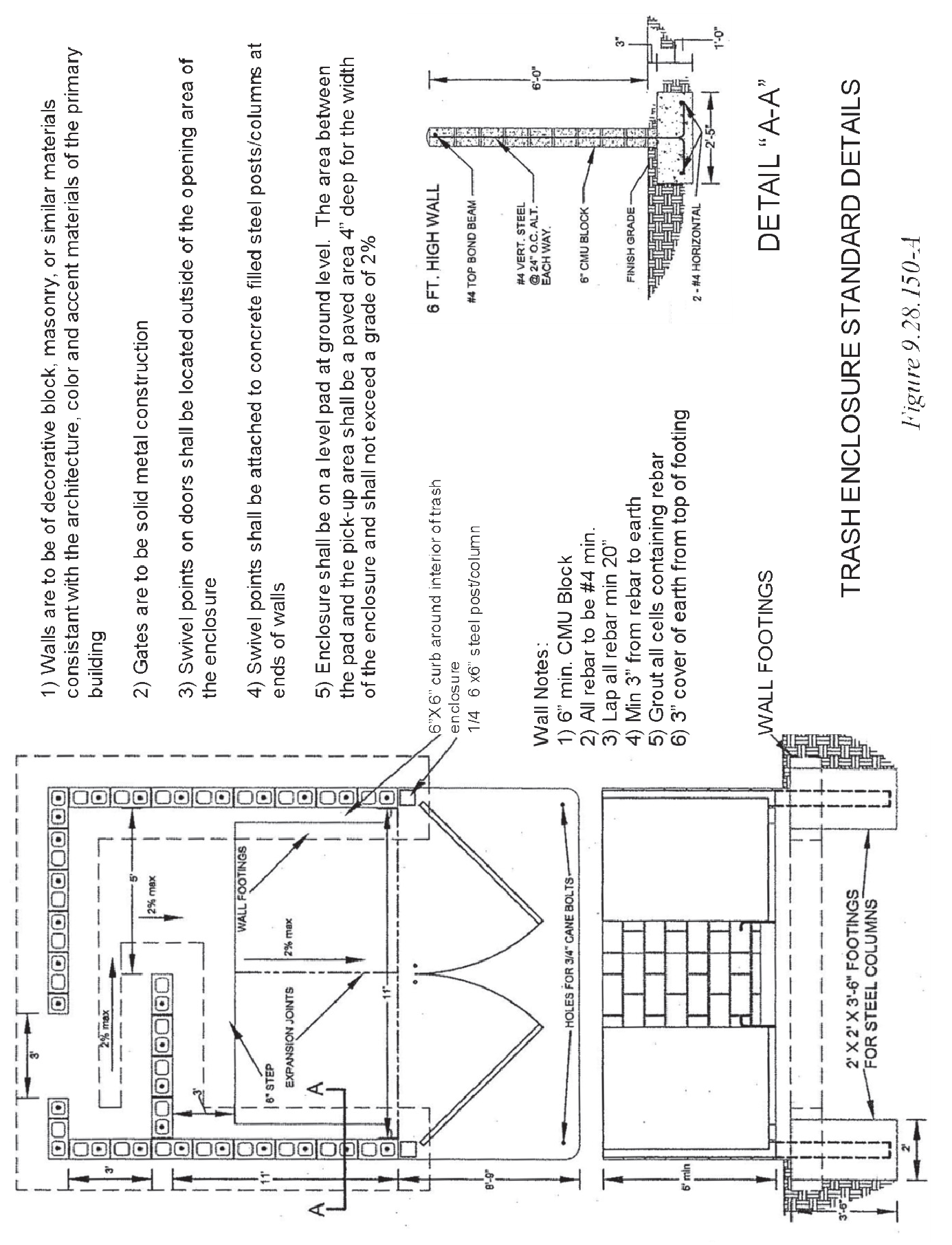
Figure 9.28.150-A
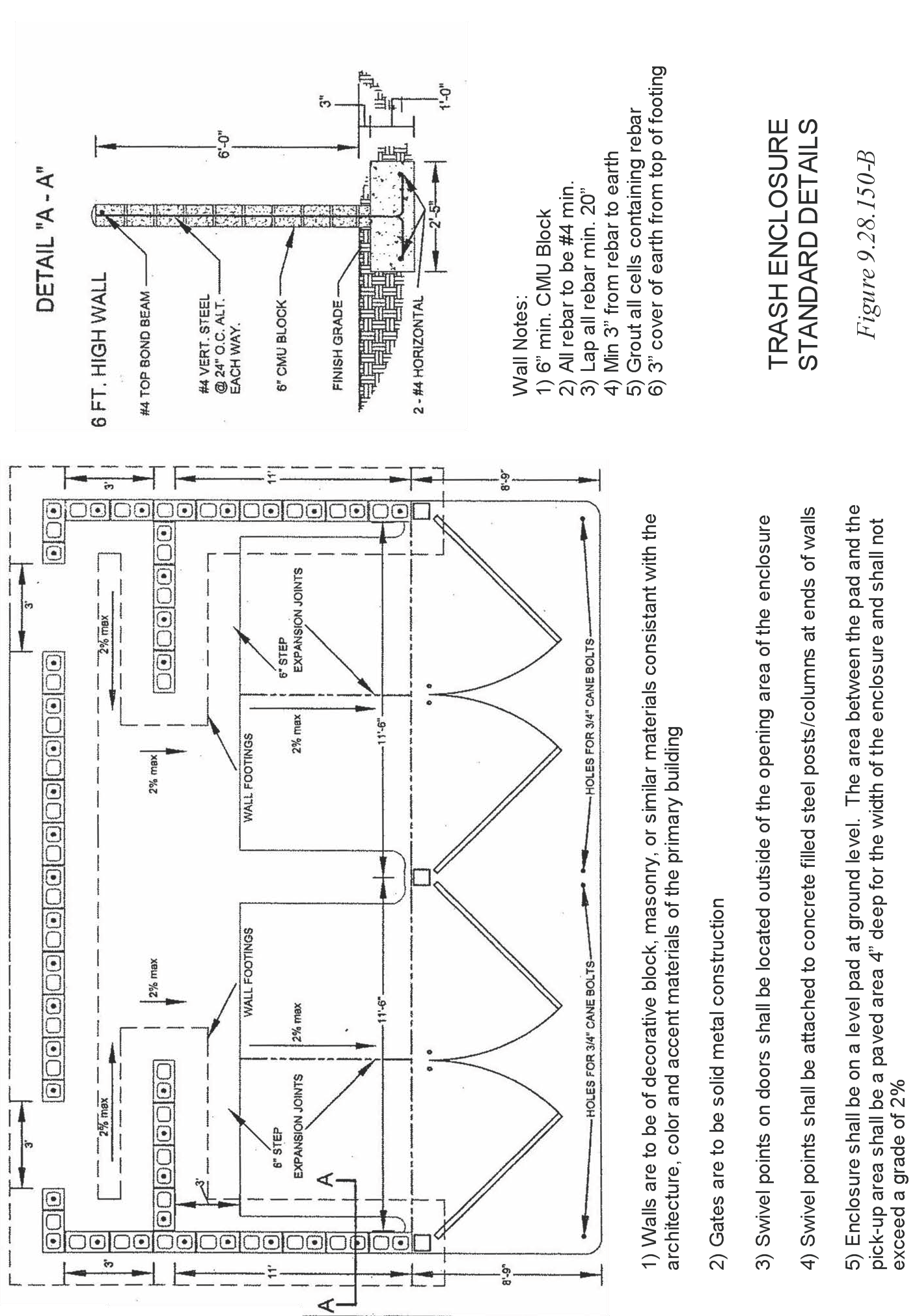
Figure 9.28.150-B